|
|
|
- Rosalyn Boyd
- 5 years ago
- Views:
Transcription
1
2
3
4
5
6
7
8
9
10
11
12
13
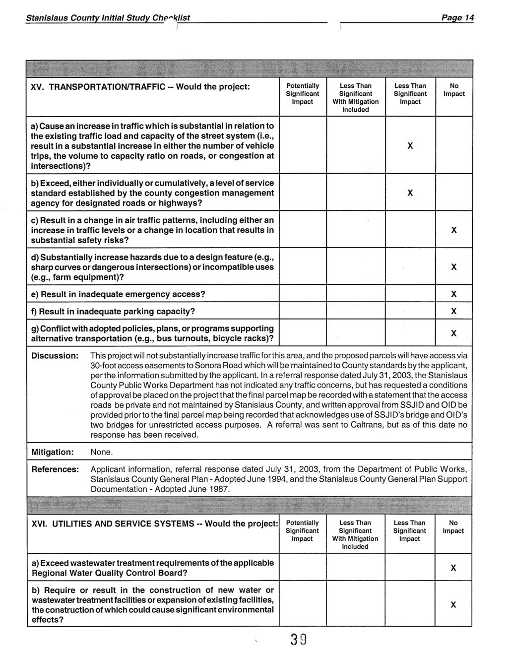
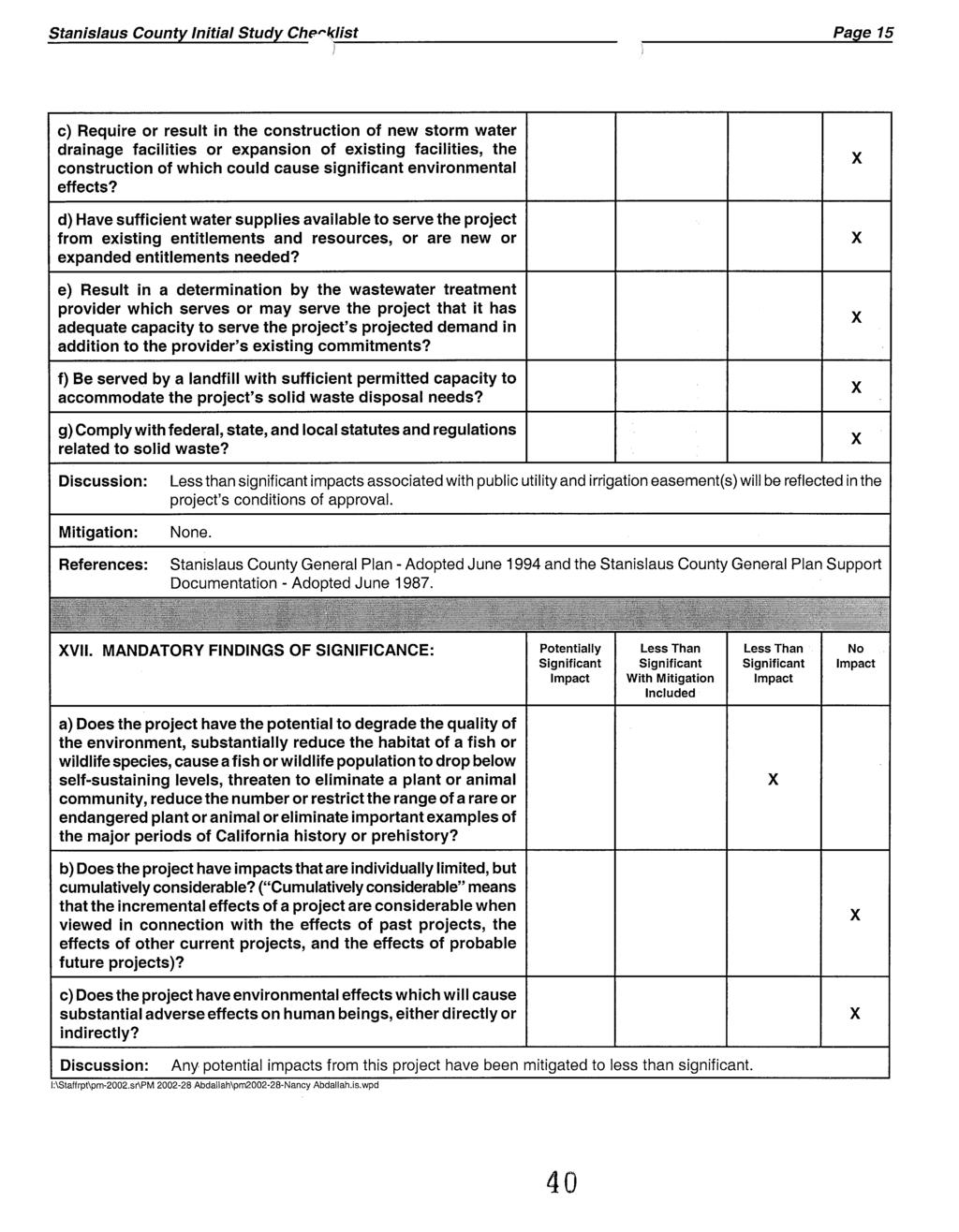
14
15
16
17
18
19
20
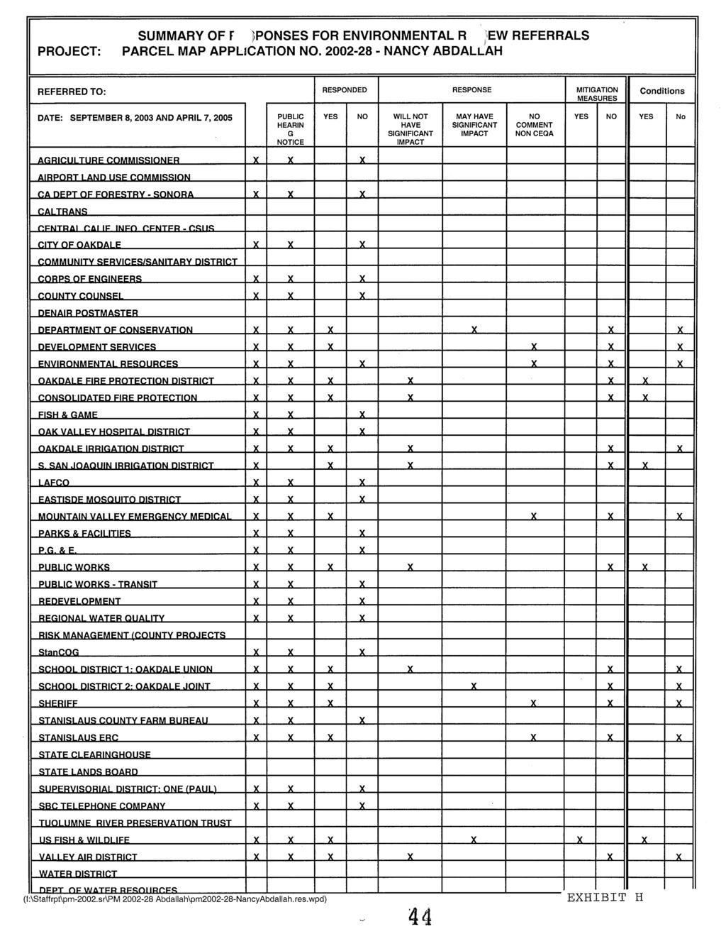
21 As Amended by the Planning Commission June 16, 2005 CONDITIONS OF APPROVAL TENTATIVE PARCEL MAP APPLICATION NO NANCY ABDALLAH Department of Public Works 1. The recorded parcel map shall be prepared by a licensed land surveyor or a registered civil engineer. 2. All existing non-public facilities and/or utilities that do not have lawful authority to occupy the road right-of-way shall be relocated onto private property upon the request of the Department of Public Works. 3. All structures not shown on the tentative parcel map shall be removed prior to the parcel map being recorded. 4. All easements shown on the tentative parcel map shall be shown on the final parcel map to be recorded. 5. A 30-foot wide public utility easement from Sonora Road to Parcels 1", 2", 3, 4", 5", 6", and 7" shall be on the parcel map to be recorded. 6. An approved 30-foot access easement, as per the Subdivision Ordinance, Section , from Sonora Road to Parcels 1", 2", 3, 4", 5", 6", and 7" shall be shown on the parcel map to be recorded. 7. The 100-foot wide Oakdale Irrigation District (OID) Canal shall be shown on the final parcel map to be recorded. 8. The 100-foot wide South San Joaquin Irrigation District (SSJID) Canal shall be shown on the final parcel map to be recorded. 9. A statement that the access roads will be private and not maintained by Stanislaus County shall be shown on the final parcel map to be recorded. 10. Written approvals from the South San Joaquin Irrigation District (SSJID) and the Oakdale Irrigation District (OID) shall be provided prior to the final parcel map being recorded that acknowledges use of SSJID s bridge and OID s two bridges for unrestricted access purposes to all parcels of Tentative Parcel Map No is permitted.
22 PM Conditions of Approval June 16, 2005 Page 2 Planning and Community Development 11. The developer shall pay all applicable Public Facilities Impact Fees and Fire Protection Development/Impact Fees as adopted by Resolution of the Board of Supervisors. For the Public Facilities Impact Fees, the fees shall be based on the Guidelines Concerning the Fee Payment Provisions established by County Ordinance C.S. 824 as approved by the County Board of Supervisors on March 11, 2003, and shall be payable at the time determined by the Department of Public Works. 12. Any construction resulting from this project shall comply with standardized dust controls adopted by the San Joaquin Valley Air Pollution Control District. 13. The subdivider is required to defend, indemnify, or hold harmless the County, its officers and employees from any claim, action, or proceedings against the County to set aside the approval of the map as set forth in Government Code Section The County shall promptly notify the subdivider of any claim, action, or proceeding to set aside the approval and shall cooperate fully in the defense. 14. Prior to the issuance of the Notice of Determination, the applicant shall pay, within five working days of Planning Commission approval, a filing fee of $50.00 to Stanislaus County Clerk/Recorder care of the Planning Department. Should the "De Minimis" finding be found invalid for any reason, the applicant/developer shall be responsible for payment of Department of Fish and Game Fees. 15. Pursuant to Section 404 of the Clean Water Act, prior to construction, the developer shall be responsible for contacting the US Army Corps of Engineers to determine if any "wetlands, "waters of the United States, or other areas under the jurisdiction of the Corps of Engineers are present on the project site, and shall be responsible for obtaining all appropriate permits or authorizations from the Corps, including all necessary water quality certifications, if necessary. 16. Pursuant to the federal and state Endangered Species Acts, prior to construction, the developer shall be responsible for contacting the US Fish and Wildlife Service and California Department of Fish and Game to determine if any special status plant or animal species are present on the project site, and shall be responsible for obtaining all appropriate permits or authorizations from these agencies, if necessary. 17. Pursuant to Section 1600 and 1603 of the California Fish and Game Code, prior to construction, the developer shall be responsible for contacting the California Department of Fish and Game and shall be responsible for obtaining all appropriate streambed alteration agreements, permits or authorizations, if necessary. 18. Pursuant to State Water Resources Control Board Order DWQ and National Pollutant Discharge Elimination System (NPDES) General Permit No. CAS000002, prior to construction, the developer shall be responsible for contacting the California Regional Water Quality Control Board to determine if a "Notice of Intent" is necessary, and shall prepare all appropriate documentation, including a Storm Water Pollution Prevention Plan (SWPPP). Once complete, and prior to construction, a copy of the SWPPP Pollution Prevention Plan shall be submitted to the Stanislaus County Department of Public Works.
23 PM Conditions of Approval June 16, 2005 Page The final recorded map shall contain the following statement: All persons purchasing lots within the boundaries of this approved map should be prepared to accept the inconveniences associated with the agricultural operations, such as noise, odors, flies, dust or fumes. Stanislaus County has determined that such inconveniences shall not be considered to be a nuisance if agricultural operations are consistent with accepted customs and standards. 20. Prior to the issuance of building permits for a dwelling, the owner/developer shall pay a fee of $ per dwelling to the County Sheriff s Department. 21. In the event the subject property is transferred so that title to the whole is no longer held by a single owner or group of owners, the new owner or group of owners of each parcel, as successors in interest of owner, shall execute a new Williamson Act Land Contract in identical terms and conditions so that at all times each parcel separately owned will be under individual contract executed by all owners of, and holders of security interests in, the particular parcel. 22. Prior to issuance of building permit(s), the applicant/developer shall contact the California Department of Forestry (Sonora Division) to see if an automatic engineered fire sprinkler system should be in installed in any building having a total floor area under one roof of 120 square feet or more, including all horizontal projections. Department of Environment Resources 23. Each parcel shall have an independent water supply. Prior to issuance of a building permit, each parcel shall have its own well. A drilling permit shall be obtained from the Department of Environmental Resources. South San Joaquin Irrigation District 24. All existing recorded South San Joaquin District easements and instrument numbers shall be shown and identified on the survey map prior to its recording. 25. To ensure that the proper easements are shown, a signature block for the District shall be placed on the plans with the following statement: The easements for SSJID as shown on this map are correct and SSJID approves of the filing of this map. 26. The landowner may not install fencing or gates within the easement areas. 27. The landowner may not plant trees or other crops within the easement areas. 28. The landowner may not otherwise interfere with the District s unrestricted access to the easement areas with labor and equipment at all times and without notice.
24 PM Conditions of Approval June 16, 2005 Page Require the applicant to enter into an agreement with the District in order to use the bridge access as a condition of approval and prior to sale the of any parcels. 30. The applicant is required to provide separate access to the parcels, apart from the District s easement areas. 31. The owner may not use the District s access easement areas for purposes other than agricultural and cattle grazing. 32. The recorded Drainage Easement in favor of South San Joaquin Irrigation District shall be shown on the parcel map with the stipulation that no permanent residential access or any improvements shall be allowed in this area. 33. Owners may not use the District bridge for general access and an alternate access will be required for any proposed permanent residential access to the parcels. 34. The owner shall obtain permission from Oakdale and South San Joaquin Irrigation Districts to construct any additional crossing of District easement or facilities. 35. The owners may not use District water. 36. The current owner shall disclose to prospective buyers the restrictions placed upon the development and use of the property in the vicinity of the South San Joaquin Irrigation District s easement. The following conditions shall be denoted on the map: 37. The owner shall be required to fence all access to the District canal and road access easement at their expense and shall not be allowed to block District access in any way. Any fencing within the District s easement will require District s approval and an encroachment agreement. 38. Acknowledgment and disclosure on the map that newly created parcels will not have access or entitlement to water or drainage services from the District. 39. No drainage of sewage, fuels, pesticides or other substances which would affect the District s use of the water for irrigation and drinking water will be allowed within the drainage area of the District s Main Canal. 40. All future owners of the parcels shown hereon are hereby made aware that certain restrictions relative to the South San Joaquin Irrigation District facilities apply. Said restrictions are incorporated within the agreement dated September 8, 1992, between said District and the current owner at that time and binding successors (the parties, and their respective assigns, successors interest, personal representatives, estates, heirs, and legatees).
25 PM Conditions of Approval June 16, 2005 Page 5 Stanislaus Consolidated Fire Protection District 41. No development without approved fire department access and water for fire protection. Oakdale Rural Fire District 42. All parcels must be accessible for emergency vehicles, consistent with County road standards. 43. Should development of these parcels occur, an $800 per parcel shall be paid at the time of permitting to the Rural Water Delivery fund. 44. All new structures will be subject to standard development fees at the time of permitting. Oakdale Irrigation District 45. Statement shall be placed on the tentative parcel map: Written approvals from the SSJID and OID shall be provided prior to the final map being recorded. Said approvals shall recognize the use of SSJID s bridge and OID s two bridges for the unrestricted access to all parcels of Tentative Parcel Map Application No Stanislaus County Environmental Review Committee 46. Prior to issuance of a building permit, access to each proposed parcel shall be to a road designed and built to County Standards and bridges shall be designed and engineered to Caltrans Standards. 47. Prior to final parcel map being recorded, a homeowner s association shall be formed and the necessary documents recorded that specify maintenance of all private access roads will be the sole responsibility of the property owners. A copy of the recorded homeowner s association shall be provided to the Department of Public Works and the Department of Planning and Community Development. Mitigation Measure 1. The vernal pool and 100-foot buffer located on Parcel 4" shall be shown on the parcel map to be recorded and an easement shall be recorded prohibiting construction in this area without prior authorization from the United States Fish and Wildlife Service and/or United States Army Corps of Engineers prior to recording the parcel map. ****** CM/er (I:\Staffrpt\PM\2002\PM Abdallah\pm NancyAbdallah.sr.wpd)
26
27
28
29

30
31
32
33
34
35
36
37
38
39
40
41
42
43
44
 AS AMENDED BY THE PLANNING COMMISSION MAY 5, 2005 CONDITIONS OF APPROVAL VESTING TENTATIVE PARCEL MAP APPLICATION NO. 2004-31 PATTERSON FROZEN FOODS Department of Public Works 1. The recorded parcel map
 AS AMENDED BY THE PLANNING COMMISSION MAY 19, 2005 CONDITIONS OF APPROVAL VESTING TENTATIVE PARCEL MAP APPLICATION NO. 2005-04 SUMMIT CORPORATE CENTER Department of Public Works 1. The recorded parcel
FORM Seven (7) copies of the completed application information forms (attached) which all owners must sign.
 copies of the completed application information forms (attached) which all owners must sign.") WILLIAMSON ACT CONTRACT CANCELLATION SAN JOAQUIN COUNTY COMMUNITY DEVELOPMENT DEPARTMENT 1810 E. HAZELTON AVENUE, STOCKTON CA 95205 BUSINESS PHONE: (209) 468-3121 Business Hours: 8:00 a.m. to 5:00 p.m.
WILLIAMSON ACT CONTRACT CANCELLATION SAN JOAQUIN COUNTY COMMUNITY DEVELOPMENT DEPARTMENT 1810 E. HAZELTON AVENUE, STOCKTON CA 95205 BUSINESS PHONE: (209) 468-3121 Business Hours: 8:00 a.m. to 5:00 p.m.
APPLICATION CHECKLIST
 DEPARTMENT OF PLANNING AND COMMUNITY DEVELOPMENT 1010 10TH Street, Suite 3400, Modesto, CA 95354 Phone: 209.525.6330 Fax: 209.525.5911 Form Available Online: http://www.stancounty.com/planning/applications.shtm
APPLICATION PROCESSING. CHECK WITH STAFF - Development Services Staff will explain the requirements and procedures to you.
 PLANNED DEVELOPMENT ZONE 1810 E. HAZELTON AVENUE, STOCKTON CA 95205 BUSINESS PHONE: (209) 468-3121 Business Hours: 8:00 a.m. to 5:00 p.m. (Monday through Friday) STEP 1 STEP 2 FEE FORM DEED SERVICES APPLICATION
(b) (c) (d) Address City, Zip Phone. (b) (c) (d) Address City, Zip Phone 6. LIST THE NUMBER AND USE OF ALL EXISTING STRUCTURES ON PROPERTY:
 (c) (d) Address City, Zip Phone. (b) (c) (d) Address City, Zip Phone 6. LIST THE NUMBER AND USE OF ALL EXISTING STRUCTURES ON PROPERTY:") DEPARTMENT OF PLANNING AND COMMUNITY DEVELOPMENT 1010 10 TH Street, Suite 3400, Modesto, CA 95354 Planning Phone: (209) 525-6330 Fax: (209) 525-5911 Building Phone: (209) 525-6557 Fax: (209) 525-7759 Form
DEPARTMENT OF PLANNING AND COMMUNITY DEVELOPMENT 1010 10 TH Street, Suite 3400, Modesto, CA 95354 Planning Phone: (209) 525-6330 Fax: (209) 525-5911 Building Phone: (209) 525-6557 Fax: (209) 525-7759 Form
Chapter 35 - PROTECTION OF AGRICULTURAL LAND*
 Chapter 35 - PROTECTION OF AGRICULTURAL LAND* Sections: 35-1 - Short title. 35-2 - Findings. 35-3 - Relationship to other laws. 35-4 - Schedule of fees and charges. 35-5 - Definitions. 35-6 - Nuisance
FEE The staff will let you know the current cost of filing an application. Make checks payable to the San Joaquin County Treasurer.
 VARIANCE 1810 E. HAZELTON AVENUE, STOCKTON CA 95205 BUSINESS PHONE: (209) 468-3121 Business Hours: 8:00 a.m. to 5:00 p.m. (Monday through Friday) STEP 1 STEP 2 APPLICATION PROCESSING STEPS CHECK WITH STAFF
APPLICATION PROCESSING
 MAJOR SUBDIVISION 1810 E. HAZELTON AVENUE, STOCKTON CA 95205 BUSINESS PHONE: (209) 468-3121 BUSINESS HOURS: 8:00 A.M. TO 5:00 P.M..(Monday through Friday) APPLICATION PROCESSING STEPS STEP 1 STEP 2 CHECK
Article II. - Right to Farm.
 Sec. 30-20. - Short title. Sec. 30-21. - Findings. Sec. 30-22. - Relationship to other laws. Sec. 30-23. - Schedule of fees and charges. Sec. 30-24. - Definitions. Sec. 30-25. - Nuisance Agricultural operation.
OWNER-INITIATED MERGER OF PARCELS APPLICATION
 REQUIREMENTS TO THE APPLICANT: OWNER-INITIATED MERGER OF PARCELS APPLICATION Please provide the following materials for your application. A complete application package will expedite your request for a
APPLICATION PROCESSING STEPS STEP 1 CHECK WITH STAFF
 APPLICATION PROCESSING STEPS STEP 1 CHECK WITH STAFF - Development Services Staff will explain the requirements and procedures to you. However, before filing an application with the Community Development
Eaton County Stormwater Management Maintenance Covenant for Private Storm Drain Systems
 Eaton County Stormwater Management Maintenance Covenant for Private Storm Drain Systems By and between:, Eaton County Drain Commissioner and Prepared by: 1045 Independence Boulevard Charlotte, MI 48813
Encroachment Permit Application Instructions
 Encroachment Permit Application Instructions Imperial Irrigation District Real Estate Section Requirements for Encroachment Permit Application Any construction or operation activities on Imperial Irrigation
MS MINOR SUBDIVISION TREVITHICK
 MS-02-015 341.12 MINOR SUBDIVISION TREVITHICK A request by Danny Trevithick for a one-lot Minor Subdivision on five acres. The property is zoned A-35 (Agricultural) District and is located ¼ mile south
EXHIBIT "A" THE PRESERVE AT WILDERNESS LAKE COMMUNITY DEVELOPMENT DISTRICT 5844 Old Pasco Road, Suite 100, Wesley Chapel, Florida 33544
 EXHIBIT "A" THE PRESERVE AT WILDERNESS LAKE COMMUNITY DEVELOPMENT DISTRICT 5844 Old Pasco Road, Suite 100, Wesley Chapel, Florida 33544 NATURAL AREAS POLICY STATEMENT The following is the policy statement
:= Information Included
 DEPARTMENT OF PLANNING AND COMMUNITY DEVELOPMENT 1010 10th Street, Suite 3400, Modesto, CA 95354 Planning Phone: (209) 525-6330 Fax: (209) 525-5911 Building Phone: (209) 525-6557 Fax: (209) 525-7759 Form
19.12 CLUSTER RESIDENTIAL DISTRICT
 Chapter 19.12 CLUSTER RESIDENTIAL DISTRICT (Adopted 12/22/2003; Ordinance #0061970). Amended 7/3/17, Ordinance #079100. Section 19.12.010 - Declaration of Intent. The Cluster Residential District provides
ATTACHMENT B: CONDITIONS OF APPROVAL. Overholtzer Tentative Parcel Map Case No. 08TPM /TPM 14,744 Date: October 13, 2010
 Overholtzer Tenative Parcel Map, 08TPM-00000-00003 Page B-1 I. PROJECT DESCRIPTION ATTACHMENT B: CONDITIONS OF APPROVAL Overholtzer Tentative Parcel Map Case No. 08TPM-00000-0003/TPM 14,744 Date: October
LEASE AGREEMENT DRAFT
 LEASE AGREEMENT THIS LEASE AGREEMENT (the Lease ), is made this day of, 20, by and between Aspen Plantation LLP, a Minnesota limited liability partnership ( Lessor ) and ( Lessee ). Either Lessor or Lessee
Chapter CLUSTER RESIDENTIAL DISTRICT (Adopted 12/22/2003; Ordinance # )
") Chapter 19.12 CLUSTER RESIDENTIAL DISTRICT (Adopted 12/22/2003; Ordinance #0061970) Section 19.12.010 - Declaration of Intent. The Cluster Residential District provides minimum standards for specified
Chapter 19.12 CLUSTER RESIDENTIAL DISTRICT (Adopted 12/22/2003; Ordinance #0061970) Section 19.12.010 - Declaration of Intent. The Cluster Residential District provides minimum standards for specified
CITY OF SONORA PLANNING COMMISSION SITE PLAN REVIEW APPLICATION
 CITY OF SONORA PLANNING COMMISSION SITE PLAN REVIEW APPLICATION APPLICANT: MAILING ADDRESS: PHONE: CELL#: EMAIL: OWNER S NAME: MAILING ADDRESS: PHONE: CELL#: EMAIL: ADDRESS OF PROPERTY INVOLVED: ASSESSOR
PLANNING COMMISSION STAFF REPORT June 18, 2015
 Community Development Department Planning Division 1600 First Street + P.O. Box 660 Napa, CA 94559-0660 (707) 257-9530 PLANNING COMMISSION STAFF REPORT June 18, 2015 AGENDA ITEM 7.B. PL15-0052 PM, GASSER
Conditional Use Permit / Standard Subdivision Application
 Conditional Use Permit / Standard Subdivision Application Name of Proposed Subdivision: Total Area (Acres) Is Proposed Subdivision to be built in phases? Number of Lots If yes, how many phases? Applicant/Owner
CONTRACT SIGNATURES. Owners of record easements across your property need not sign if they are for road, flood control or public utility purposes.
 FARMLAND SECURITY ZONE SAN JOAQUIN COUNTY COMMUNITY DEVELOPMENT DEPARTMENT 1810 E. HAZELTON AVENUE, STOCKTON CA 95205 BUSINESS PHONE: (209) 468-3121 Business Hours: 8:00 a.m. to 5:00 p.m. (Monday through
FOR OFFICE USE ONLY Date Submitted Received By Fees Paid $ Receipt No. Received By Application No. Application Complete Final Action Date
 COMMERCIAL, INDUSTRIAL, & MANUFACTURING SITE PLAN (CIM) APPLICATION Mariposa County Planning Department 5100 Bullion Street, P.O. Box 2039 Mariposa, CA 95338 Telephone (209) 966-5151 FAX (209) 742-5024
PARTNERSHIP AGREEMENT
 Agreement #_ WORKING GRASSLAND PARTNERSHIP AGREEMENT This agreement (with attachments) made this day of, 20, by and between Name (Husband/Wife) and Address, herein after referred to as (whether one or
APPLICATION PROCESSING STEPS
 LOT LINE ADJUSTMENT 1810 E. HAZELTON AVENUE, STOCKTON CA 95205 BUSINESS PHONE: (209) 468-3121 Business Hours: 8:00 a.m. to 5:00 p.m. (Monday through Friday) APPLICATION PROCESSING STEPS STEP 1 CHECK WITH
Applicant Address: 3325 Longview Drive, St 311. State/Zip: Ca/ Phone: (916)
") Planning Application Form Cover Sheet This application form is required as part of any planning development request. Other required items are indicated on the accompanying instructions and checklists.
Planning Application Form Cover Sheet This application form is required as part of any planning development request. Other required items are indicated on the accompanying instructions and checklists.
Mariposa County Public Works Department (209) (for road encroachments, road improvements, and engineering issues)
 (for road encroachments, road improvements, and engineering issues)") CONDITIONAL USE PERMIT GENERAL INFORMATION AND APPLICATION Mariposa County Planning Department 5100 Bullion Street, P.O. Box 2039 Mariposa, CA 95338 Telephone (209) 966-5151 FAX (209) 742-5024 www.mariposacounty.org
CONDITIONAL USE PERMIT GENERAL INFORMATION AND APPLICATION Mariposa County Planning Department 5100 Bullion Street, P.O. Box 2039 Mariposa, CA 95338 Telephone (209) 966-5151 FAX (209) 742-5024 www.mariposacounty.org
Sabine River Authority, State of Louisiana
 Sabine River Authority, State of Louisiana Policy for Administering the Shoreline Management Plan (SMP) Encroachments Adopted by SRA Board of Commissioners: Introduction The Federal Energy Regulatory Commission
DEPARTMENT OF FISH AND WILDLIFE ENVIRONMENTAL FILING FEES (Fish and Game Code 711.4)
") PARCEL MAP PROCESS DEPARTMENT OF PLANNING AND BUILDING SERVICES 707 Nevada Street, Suite 5 Susanville, CA 96130-3912 (530) 251-8269 (530) 251-8373 (fax) www.co.lassen.ca.us A subdivision is any division
PARCEL MAP PROCESS DEPARTMENT OF PLANNING AND BUILDING SERVICES 707 Nevada Street, Suite 5 Susanville, CA 96130-3912 (530) 251-8269 (530) 251-8373 (fax) www.co.lassen.ca.us A subdivision is any division
FILING REQUIREMENTS FOR SUBMITTING APPLICATIONS
 S T A N I S L A U S L A F C O Stanislaus Local Agency Formation Commission 1010 10th Street, 3 rd Floor Modesto, CA 95354 (209) 525-7660 FAX (209) 525-7643 www.stanislauslafco.org FILING REQUIREMENTS FOR
City of San Juan Capistrano Agenda Report
 ITEM F2 City of San Juan Capistrano Agenda Report TO: FROM: Planning Commission Prepared & Submitted by: David Contreras~ting Assistant Development Services Director c;:::e._,~.y.. Reviewed by: Sergio
Legally Described as: Lot(s) - in BROOKHAVEN ESTATES PLAT 1, pursuant to the Plat thereof (the, Property ).
 - in BROOKHAVEN ESTATES PLAT 1, pursuant to the Plat thereof (the, Property ).") LOT PURCHASE AGREEMENT FOR BROOKHAVEN ESTATES PLAT 1 SUBDIVISION Buyer(s) First, Middle, Last or Full Company Name Current Address PRINT NAMES OF BUYERS AS THEY ARE TO APPEAR ON DEED (WITH MIDDLE INITIALS,
LOT PURCHASE AGREEMENT FOR BROOKHAVEN ESTATES PLAT 1 SUBDIVISION Buyer(s) First, Middle, Last or Full Company Name Current Address PRINT NAMES OF BUYERS AS THEY ARE TO APPEAR ON DEED (WITH MIDDLE INITIALS,
Elko County Community Development
 Elko County Community Development Planning & Zoning Division 540 COURT ST SUITE 104, ELKO, NEVADA 89801 (775) 738-6816 Fax (775) 738-4581 jkingwell@elkocountnv.net www.elkocountynv.net LOCAL AREA PRIVATE
APPENDIX 7 SPECIAL NOTES FOR PLATS AND CONSTRUCTION PLANS
 APPENDIX 7 SPECIAL NOTES FOR PLATS AND CONSTRUCTION PLANS EASEMENT AND DRAINAGE STATEMENT TO BE PLACED ON PLANS AND ALL SUBDIVISION PLATS REQUIRING SOIL DRAINAGE MANAGEMENT PLANS The easements designated
MINOR SUBDIVISION INFORMATION
 A. POINTS OF CONTACT: MINOR SUBDIVISION INFORMATION Surveyor: Address: Phone #: Fax # E-Mail Address: Representative (If different from applicant): Address: Phone #: Fax # E-Mail Address: B. GENERAL INFORMATION:
Community Development Department Planning Division 1600 First Street + P.O. Box 660 Napa, CA (707)
") Community Development Department Planning Division 1600 First Street + P.O. Box 660 Napa, CA 94559-0660 (707) 257-9530 PLANNING COMMISSION STAFF REPORT MARCH 3, 2016 AGENDA ITEM # 7.B. File No. 15-0158
Community Development Department Planning Division 1600 First Street + P.O. Box 660 Napa, CA 94559-0660 (707) 257-9530 PLANNING COMMISSION STAFF REPORT MARCH 3, 2016 AGENDA ITEM # 7.B. File No. 15-0158
PARTNERSHIP AGREEMENT
 Agreement #_ WORKING GRASSLAND PARTNERSHIP AGREEMENT This agreement (with attachments) made this day of, 20, by and between Name and Address, herein after referred to as (whether one or more) and the North
TENTATIVE PARCEL MAP APPLICATION GUIDE TENTATIVE PARCEL MAP APPLICATION REQUIREMENTS
 TENTATIVE PARCEL MAP APPLICATION GUIDE SISKIYOU COUNTY PLANNING DIVISION 806 South Main Street, Yreka CA 96097 Phone: (530) 841-2100 / Fax: (530) 841-4076 TENTATIVE PARCEL MAP APPLICATION REQUIREMENTS
STANISLAUS COUNTY PLANNING COMMISSION STAFF REPORT
 STANISLAUS COUNTY PLANNING COMMISSION STAFF REPORT GENERAL PLAN AMENDMENT APPLICATION NO. 2005-08, COMMUNITY PLAN AMENDMENT APPLICATION NO- 2005-03, VESTING TENTATIVE SUBDIVISION MAP APPLICATION NO. 2005-04
SANTA BARBARA COUNTY ZONING ADMINISTRATOR STAFF REPORT November 20, 2015
 SANTA BARBARA COUNTY ZONING ADMINISTRATOR STAFF REPORT November 20, 2015 PROJECT: Acquistapace Tentative Parcel Map HEARING DATE: December 7, 2015 STAFF/PHONE: Dana Eady, (805) 934-6266 GENERAL INFORMATION
Referral Early Consultation
 DEPARTMENT OF PLANNING AND COMMUNITY DEVELOPMENT 1010 10 TH Street, Suite 3400, Modesto, CA 95354 Planning Phone: (209) 525-6330 Fax: (209) 525-5911 Building Phone: (209) 525-6557 Fax: (209) 525-7759 Date:
ORDINANCE NO. 118 SECTION 3. DISCLOSURE REQUIREMENTS Ð NEW CONSTRUCTION
 ORDINANCE NO. 118 AN ORDINANCE OF MILFORD TOWNSHIP, BUCKS COUNTY, PENNSYLVANIA, REQUIRING SELLERS OF NEW RESIDENTIAL PROPERTY TO DISPLAY THE FINAL APPROVED SUBDIVISION PLAN, TO SPECIFICALLY SHOW THIS PLAN
Referral Early Consultation
 DEPARTMENT OF PLANNING AND COMMUNITY DEVELOPMENT 1010 10 th Street, Suite 3400, Modesto, CA 95354 Phone: 209.525.6330 Fax: 209.525.5911 Date: December 15, 2017 Referral Early Consultation To: Distribution
CONSERVATION EASEMENT INCLUDING MITIGATION
 After recording return to: GRANTOR: GRANTEE: GRANTEE (Trustee): LEGAL DESCRIPTION: TAX PARCEL I.D. #: REFERENCE # s: WHATCOM COUNTY N/A CONSERVATION EASEMENT INCLUDING MITIGATION This grant of a conservation
Tentative Map Application Review Procedures
 FOR REFERENCE ONLY This page is not part of the application. Tentative Map Application Review Procedures The tentative map process in Churchill County is designed to provide a mechanism in order to divide
PRINT NAMES OF BUYERS AS ARE THEY ARE TO APPEAR ON DEED (WITH MIDDLE INITIALS, ETC.)
") Diamond Development, LLC 309 E. 1st Street Ankeny, IA 50021 LOT PURCHASE AGREEMENT FOR PINE VIEW ESTATES PLAT 3 SUBDIVISION Buyer(s) First, Middle, Last or Full Company Name Social Security #/Federal ID#
Diamond Development, LLC 309 E. 1st Street Ankeny, IA 50021 LOT PURCHASE AGREEMENT FOR PINE VIEW ESTATES PLAT 3 SUBDIVISION Buyer(s) First, Middle, Last or Full Company Name Social Security #/Federal ID#
CHAPTER 3 PERMITS, PLANS AND ANNEXATION
 CHAPTER 3 PERMITS, PLANS AND ANNEXATION SECTION: 10-3-1: General Regulations 10-3-2: Building Permit 10-3-3: Plans 10-3-4: Certificate of Compliance and Occupancy 10-3-5: Conditional Use Permits 10-3-6:
PC RESOLUTION NO. 15~11-10~01 CONDITIONAL USE PERMIT (CUP)
") PC RESOLUTION NO. 15~11-10~01 CONDITIONAL USE PERMIT (CUP) 15-005 A RESOLUTION OF THE PLANNING COMMISSION OF THE CITY OF SAN JUAN CAPISTRANO, CALIFORNIA APPROVING A MUSIC EDUCATION FACILITY IN EXISTING
PC RESOLUTION NO. 15~11-10~01 CONDITIONAL USE PERMIT (CUP) 15-005 A RESOLUTION OF THE PLANNING COMMISSION OF THE CITY OF SAN JUAN CAPISTRANO, CALIFORNIA APPROVING A MUSIC EDUCATION FACILITY IN EXISTING
Wells County Area Plan Commission Requirements for a Wind Energy Conversion System (WECS) Testing Facility or Communication Tower Development Plan
 Testing Facility or Communication Tower Development Plan") Wells County Area Plan Commission Requirements for a Wind Energy Conversion System (WECS) Testing Facility or Communication Tower Development Plan Filing and Meeting dates are available at the Area Plan
Wells County Area Plan Commission Requirements for a Wind Energy Conversion System (WECS) Testing Facility or Communication Tower Development Plan Filing and Meeting dates are available at the Area Plan
GENERAL PLAN DESIGNATIONS (Exhibit A): MDR (Medium Density Residential) Designation. SURROUNDING: MDR (Medium Density Residential) Designation
: MDR (Medium Density Residential) Designation. SURROUNDING: MDR (Medium Density Residential) Designation") STAFF REPORT March 3, 2015 PRJ #2014-007 PM #4201 CZ #2014-007 GENERAL PLAN DESIGNATIONS (Exhibit A): SITE: MDR (Medium Density Residential) Designation SURROUNDING: MDR (Medium Density Residential) Designation
STAFF REPORT March 3, 2015 PRJ #2014-007 PM #4201 CZ #2014-007 GENERAL PLAN DESIGNATIONS (Exhibit A): SITE: MDR (Medium Density Residential) Designation SURROUNDING: MDR (Medium Density Residential) Designation
RESOLUTION NO. PC
 RESOLUTION NO. PC 13-1060 A RESOLUTION OF THE PLANNING COMMISSION OF THE CITY OF WEST HOLLYWOOD, APPROVING AN AMENDMENT TO A CONDITIONAL USE PERMIT, AND APPROVAL OF A DEVELOPMENT PERMIT AND PARKING USE
APPLICATION PROCESSING. Seven (7) copies of a site plan (see attached). Seven (7) copies of the recorded deed(s) of the properties involved.
 copies of a site plan (see attached). Seven (7) copies of the recorded deed(s) of the properties involved.") REVERSION OF ACREAGE San Joaquin County Community Development Department 1810 East Hazelton Avenue, Stockton CA 95205 Telephone: (209) 468-3121 Business Hours: 8:00 a.m. to 5:00p.m. (Monday through Friday,
REVERSION OF ACREAGE San Joaquin County Community Development Department 1810 East Hazelton Avenue, Stockton CA 95205 Telephone: (209) 468-3121 Business Hours: 8:00 a.m. to 5:00p.m. (Monday through Friday,
THIS DECLARATION OF RESTRICTIVE COVENANTS is made this day of, 20, by ("Covenantor"). RECITALS
. RECITALS") Model for Use with Permits Without Mitigation Plans STATE OF COUNTY OF DECLARATION OF RESTRICTIVE COVENANTS THIS DECLARATION OF RESTRICTIVE COVENANTS is made this day of, 20, by ("Covenantor"). RECITALS
Model for Use with Permits Without Mitigation Plans STATE OF COUNTY OF DECLARATION OF RESTRICTIVE COVENANTS THIS DECLARATION OF RESTRICTIVE COVENANTS is made this day of, 20, by ("Covenantor"). RECITALS
MODEL DEED RESTRICTION FOR THE PENNSYLVANIA STATE PROGRAMMATIC GENERAL PERMIT-3 (PASPGP-3) DECLARATION OF RESTRICTIVE COVENANTS FOR CONSERVATION
 DECLARATION OF RESTRICTIVE COVENANTS FOR CONSERVATION") MODEL DEED RESTRICTION FOR THE PENNSYLVANIA STATE PROGRAMMATIC GENERAL PERMIT-3 (PASPGP-3) DECLARATION OF RESTRICTIVE COVENANTS FOR CONSERVATION THIS DECLARATION OF RESTRICTIVE COVENANTS FOR CONSERVATION
MODEL DEED RESTRICTION FOR THE PENNSYLVANIA STATE PROGRAMMATIC GENERAL PERMIT-3 (PASPGP-3) DECLARATION OF RESTRICTIVE COVENANTS FOR CONSERVATION THIS DECLARATION OF RESTRICTIVE COVENANTS FOR CONSERVATION
1. The reason provided for the opposing votes was that the two commissioners wanted something else to be developed on their parcel.
 Agenda Item #6.2 SUBJECT: PUBLIC HEARING - APPEAL OF PLANNING COMMISSION DECISION DENYING THE APPROVAL OF THE TENTATIVE PARCEL MAP, CONDITIONAL USE PERMIT, AND SITE AND ARCHITECTURAL REVIEW FOR THE CONSTRUCTION
Trio Petroleum, Inc. (PLN010302)
") LYNNE MOUNDAY ZONING ADMINISTRATOR STATE OF CALIFORNIA COUNTY OF MONTEREY RESOLUTION NO. 010302 A.P.# 424-091-021-000 In the matter of the application of Trio Petroleum, Inc. (PLN010302) FINDINGS & DECISION
LYNNE MOUNDAY ZONING ADMINISTRATOR STATE OF CALIFORNIA COUNTY OF MONTEREY RESOLUTION NO. 010302 A.P.# 424-091-021-000 In the matter of the application of Trio Petroleum, Inc. (PLN010302) FINDINGS & DECISION
This division may be cited as the Subdivision Map Act.
 CALIFORNIA CODES GOVERNMENT CODE SECTION 66410-66413.5 66410. This division may be cited as the Subdivision Map Act. 66411. Regulation and control of the design and improvement of subdivisions are vested
EBMUD PROPERTY PURCHASE AGREEMENT AND JOINT ESCROW INSTRUCTIONS (PPA-JEI)
") PROPERTY LOCATION Camanche Parkway North, Ione, CA 95640 COUNTY Amador County APN 003-470-003 (portion) TITLE COMPANY Old Republic Title Company PROJECT Amador County West Sale EBMUD PROPERTY PURCHASE
PROPERTY LOCATION Camanche Parkway North, Ione, CA 95640 COUNTY Amador County APN 003-470-003 (portion) TITLE COMPANY Old Republic Title Company PROJECT Amador County West Sale EBMUD PROPERTY PURCHASE
City of Melissa, Texas Plat Dedication Language
 City of Melissa, Texas Plat Dedication Language [INCLUDE THE FOLLOWING DEDICATION LANGUAGE FOR INDIVIDUALS (MODIFY APPROPRIATELY TO REFLECT EXACTLY AS SHOWN ON PROPERTY DEED)]: NOW THEREFORE, KNOW ALL
DECLARATION OF RESTRICTIVE COVENANTS
 DECLARATION OF RESTRICTIVE COVENANTS The Declarant,, is the fee simple owner of the certain real property located in County, Kansas, as described on Exhibit A, which is attached hereto and incorporated
SELLER DISCLOSURE STATEMENT UNIMPROVED PROPERTY
 Seller Disclosure Statement-Unimproved Page 1 of 6 SELLER: Gerald & Judith 1 Seller To be used in transfers of unimproved residential real property, including property zoned for residential use that is
SUBMITTAL REQUIREMENTS: The number indicates the number of copies for submittal (if applicable).
.") Office Use Only Preliminary Long Plat Long Subdivision Applicant Checklist PLANNING, COMMUNITY, & ECONOMIC DEVELOPMENT DEPARTMENT PRELIMINARY LONG PLAT LONG SUBDIVISION CHECKLIST Mailing Address: P.O.
Office Use Only Preliminary Long Plat Long Subdivision Applicant Checklist PLANNING, COMMUNITY, & ECONOMIC DEVELOPMENT DEPARTMENT PRELIMINARY LONG PLAT LONG SUBDIVISION CHECKLIST Mailing Address: P.O.
APPLICATION FOR IRRIGATION SERVICE ABANDONMENT AGREEMENT
 APPLICATION FOR IRRIGATION SERVICE ABANDONMENT AGREEMENT 1. Applicant s name 2. Landowner s name 3. Mailing Address Telephone # 4. Location of requested property :APN# Address: 5. When was the last time
Protective and Restrictive Covenants
 Protective and Restrictive Covenants Marion s Garden Homeowners Association DECLARATION OF PROTECTIVE AND RESTRICTIVE COVENANTS MARION S GARDEN SUBDIVISION CITY OF FORT PIERRE, STANLEY COUNTY, SOUTH DAKOTA
Conditions of Approval Tentative Map Amendment -Shadowbrook January 11, 2016
 City of Manteca Community Development Department Conditions of Approval -Shadowbrook January 11, 2016 Project File Numbers: TSM 15-93 Project Name: Shadowbrook Amendment Project APN: 218-130-01, 04, 05,
1.0 REQUEST. SANTA BARBARA COUNTY ZONING ADMINISTRATOR Coastal Zone Staff Report for Vincent New Single-Family Dwelling & Septic System
 SANTA BARBARA COUNTY ZONING ADMINISTRATOR Coastal Zone Staff Report for Vincent New Single-Family Dwelling & Septic System Hearing Date: February 26, 2007 Supervisorial District: First Staff Report Date:
PENINSULA TOWNSHIP LAND DIVISION ORDINANCE TOWNSHIP OF PENINSULA COUNTY OF GRAND TRAVERSE, STATE OF MICHIGAN ORDINANCE NO OF 2012
 PENINSULA TOWNSHIP LAND DIVISION ORDINANCE TOWNSHIP OF PENINSULA COUNTY OF GRAND TRAVERSE, STATE OF MICHIGAN ORDINANCE NO OF 2012 AN ORDINANCE TO REGULATE THE DIVISION OF EXISTING PARCELS OF LAND PURSUANT
292 West Beamer Street Woodland, CA (530) FAX (530)
 FAX (530)") - County of Yolo PLANNING AND PUBLIC WORKS DEPARTMENT John Bencomo DIRECTOR 292 West Beamer Street Woodland, CA 95695-2598 (530) 666-8775 FAX (530) 666-8728 www.yolocounty.org PLANNING COMMISSION STAFF
- County of Yolo PLANNING AND PUBLIC WORKS DEPARTMENT John Bencomo DIRECTOR 292 West Beamer Street Woodland, CA 95695-2598 (530) 666-8775 FAX (530) 666-8728 www.yolocounty.org PLANNING COMMISSION STAFF
What is a Conditional Use? When is a Conditional Use Necessary? Who decides if I will get a Conditional Use Permit
 What is a Conditional Use? A conditional use is a land use or development that would not be appropriate generally but may be allowed with appropriate controls upon a finding that certain conditions as
Chapter HABITAT CONSERVATION PLAN / NATURAL COMMUNITY CONSERVATION PLAN IMPLEMENTATION ORDINANCE
 Chapter 15.108 HABITAT CONSERVATION PLAN / NATURAL COMMUNITY CONSERVATION PLAN IMPLEMENTATION ORDINANCE Sections: 15.108.010 Purpose. 15.108.020 Definitions. 15.108.030 Applicability 15.108.040 Responsibility
Fresno Local Agency Formation Commission Change of Organization/Reorganization Application
 Fresno Local Agency Formation Commission Change of Organization/Reorganization Application Not for use with update/revision to sphere of influence, city incorporation, or district formation. Contact LAFCo
AGREEMENT. Private Stormwater Management Facilities Operation and Maintenance And Right of Entry
 RECORDING REQUESTED BY: City of Arroyo Grande WHEN RECORDED, PLEASE RETURN TO (SYSTEM OWNER ADDRESS) AGREEMENT Private Stormwater Management Facilities Operation and Maintenance And Right of Entry SWP
(a) It is a goal of the city general plan to work cooperatively with the counties of Yolo and Solano to
 It is a goal of the city general plan to work cooperatively with the counties of Yolo and Solano to") City of Davis Municipal Code Chapter 40A Right to Farm and Farmland Preservation 40A.01.010 Purpose. (a) It is a goal of the city general plan to work cooperatively with the counties of Yolo and Solano
City of Davis Municipal Code Chapter 40A Right to Farm and Farmland Preservation 40A.01.010 Purpose. (a) It is a goal of the city general plan to work cooperatively with the counties of Yolo and Solano
VARIANCE APPLICATION
 REQUIREMENTS TO THE APPLICANT: Please provide the following materials for your application. A complete application package will expedite your public hearing before the Planning and Preservation Commission.
City of San Juan Capistrano Supplemental Agenda Report
 City of San Juan Capistrano Supplemental Agenda Report TO: FROM: DATE: SUBJECT: Planning Commission Development Services Department... / Submitted by: Charles View, Development Services Dire ct~.. J,J._
This document was prepared by: Albemarle County Attorney County of Albemarle 401 McIntire Road Charlottesville, Virginia 22902
 This document was prepared by: Albemarle County Attorney County of Albemarle 401 McIntire Road Charlottesville, Virginia 22902 Tax Map and Parcel Number This deed is exempt from taxation under Virginia
TOWN OF WOODSIDE. Report to Town Council Agenda Item 6 From: Susan George, Town Manager July 26, 2011
 TOWN OF WOODSIDE Report to Town Council Agenda Item 6 From: Susan George, Town Manager July 26, 2011 SUBJECT: RESOLUTION APPROVING A HOLD HARMLESS AND INDEMNIFICATION AGREEMENT FOR THE PROPERTY LOCATED
CITY OF ESCONDIDO Planning Division 201 North Broadway Escondido, CA (760) Fax: (760)
 Fax: (760)") CITY OF ESCONDIDO Planning Division 201 North Broadway Escondido, CA 92025-2798 (760) 839-4671 Fax: (760) 839-4313 SECOND DWELLING UNIT PERMIT FOR INTERNAL USE ONLY Case No: Date Submitted: Fees Submitted:
CITY OF ESCONDIDO Planning Division 201 North Broadway Escondido, CA 92025-2798 (760) 839-4671 Fax: (760) 839-4313 SECOND DWELLING UNIT PERMIT FOR INTERNAL USE ONLY Case No: Date Submitted: Fees Submitted:
TRANSBAY JOINT POWERS AUTHORITY
 STAFF REPORT FOR CALENDAR ITEM NO.: 15 FOR THE MEETING OF: March 10, 2011 TRANSBAY JOINT POWERS AUTHORITY BRIEF DESCRIPTION: Approving a Temporary Easement Agreement (Temporary Easement) between the Transbay
APPLICATION INFORMATION
 DEPARTMENT OF PLANNING AND COMMUNITY DEVELOPMENT 1010 10 TH Street, Suite 3400, Modesto, CA 95354 Planning Phone: (209) 525-6330 Fax: (209) 525-5911 Building Phone: (209) 525-6557 Fax: (209) 525-7759 Form
DEED OF EASEMENT STATE OF NEW JERSEY AGRICULTURE RETENTION AND DEVELOPMENT PROGRAM. BETWEEN, whose address is and is referred to as the Grantor;
 Page 1 of 8 E3-E DEED OF EASEMENT STATE OF NEW JERSEY AGRICULTURE RETENTION AND DEVELOPMENT PROGRAM This Deed is made, 20. BETWEEN, whose address is and is referred to as the Grantor; AND, whose address
DEED OF EASEMENT STATE OF NEW JERSEY AGRICULTURE RETENTION AND DEVELOPMENT PROGRAM. This Deed is made, 20. BETWEEN, and is referred to as the Grantor;
 DEED OF EASEMENT E3E Page 1 of 7 STATE OF NEW JERSEY AGRICULTURE RETENTION AND DEVELOPMENT PROGRAM This Deed is made, 20 BETWEEN whose address is, and is referred to as the Grantor; AND the State Agriculture
Storm Water Management BMP Maintenance Agreement City of St. George, Utah
 RECORDED, MAIL TO: St. George City 175 East 200 North St. George, UT 84770 Tax ID: BMP Maintenance Agreement City of St. George, Utah WHEREAS, the Property Owner recognizes that the post construction storm
Fresno Local Agency Formation Commission Change of Organization/Reorganization Application
 Fresno Local Agency Formation Commission Change of Organization/Reorganization Application Not for use with update/revision to sphere of influence, city incorporation, or district formation. Contact LAFCo
Reference Document Do Not Copy
 Parcel Map, Division Into Large Parcels, and Reversion to Acreage Map Review Procedures The parcel map process in Churchill County is designed to provide a mechanism in order to divide a parcel or parcels
ARTICLE PERMISSIVE USES. A building or premises shall be permitted to be used for the following purposes in the A-1 Agricultural District:
 ARTICLE 3.00 A-1 AGRICULTURAL SECTIONS: 3.01 Intent 3.02 Permissive Uses 3.03 Permitted Special Uses 3.04 Conditional Uses 3.05 Accessory Uses 3.06 Parking Regulations 3.07 Sign Regulations 3.08 Density,
COUNTY OF SACRAMENTO CALIFORNIA
 COUNTY OF SACRAMENTO CALIFORNIA Control No.: PLNP2007-00537 Type: PMR TO: FROM: SUBJECT: SUBDIVISION REVIEW COMMITTEE PLANNING AND COMMUNITY DEVELOPMENT DEPARTMENT CHRIS BOTTIMORE TENTATIVE PARCEL MAP
Chapter SWAINSON S HAWK IMPACT MITIGATION FEES
 The Swainson s Hawk ordinance can also be viewed online at: http://qcode.us/codes/sacramentocounty/ Once at the website, click on Title 16 BUILDINGS AND CONSTRUCTION, then Chapter 16.130 SWAINSON S HAWK
Larimer County Planning Dept. Procedural Guide for 1041 PERMITS
 - Larimer County Planning Dept. Procedural Guide for 1041 PERMITS PLEASE NOTE: A PRE-APPLICATION CONFERENCE IS REQUIRED PRIOR TO SUBMITTING THIS APPLICATION. PURPOSE: State Statutes allow local governments
OLIVENHAIN MUNICIPAL WATER DISTRICT PRIVATE ENCROACHMENT PERMIT NO. R-E-C-I-T-A-L-S
 RECORDING REQUESTED BY & WHEN RECORDED RETURN TO: Olivenhain Municipal Water District 1966 Olivenhain Road Encinitas, California, 92024-5699 (This space for recorder s use) A.P.N. No. OLIVENHAIN MUNICIPAL
Planned Residential Development ( PRD ) Application
 Application") FOR PLANNING USE ONLY Application # PRD Application Fee $ Receipt No. Filing Date Completeness Date Planned Residential Development ( PRD ) Application A. PROJECT INFORMATION 1. Project Name: 2. Address
FOR PLANNING USE ONLY Application # PRD Application Fee $ Receipt No. Filing Date Completeness Date Planned Residential Development ( PRD ) Application A. PROJECT INFORMATION 1. Project Name: 2. Address
COASTAL DEVELOPMENT PERMIT APPLICATION
 COUNTY OF MENDOCINO DEPARTMENT OF PLANNING AND BUILDING SERVICES 501 Low Gap Road, Room 1440 Ukiah, California 95482 Telephone 707-463-4281 FAX 707-463-5709 790 South Franklin Street Fort Bragg, California
DRAFT Resolution File No.: CU
 DRAFT Resolution A RESOLUTION OF THE ST. LUCIE COUNTY BOARD OF COUNTY COMMISSIONERS GRANTING COMPOST USA OF THE TREASURE COAST, LLC CONDITIONAL USE PERMIT APPROVAL FOR THE ESTABLISHMENT OF A BIOSOLIDS
ALBERTA SURFACE LEASE AGREEMENT
 CAPL 95 ALBERTA ALBERTA SURFACE LEASE AGREEMENT This Indenture of Lease made the day of A.D. 20 BETWEEN of. in the Province of Alberta, (hereinafter called the Lessor ) and (hereinafter called the Lessee
BOUNDARY LINE ADJUSTMENT APPLICATION GUIDE
 BOUNDARY LINE ADJUSTMENT APPLICATION GUIDE SISKIYOU COUNTY PLANNING DIVISION 806 South Main Street, Yreka CA 96097 Phone: (530) 841-2100 / Fax: (530) 841-4076 WHAT IS A BOUNDARY LINE ADJUSTMENT? A Boundary
Buy and Sell Agreement
 Buy and Sell Agreement A-1 Offer Date:, 20 Selling Office: Selling REALTOR : Selling REALTOR s Email Address: Selling REALTOR s Phone: Listing Office: Listing REALTOR : Listing REALTOR s Email Address:
PARCEL MERGER APPLICATION
 CITY OF WILDOMAR Planning Department 23873 Clinton Keith Road, Suite #201 Wildomar, CA 92595 Tel. (951) 677-7751 Fax. (951) 698-1463 For office use only. Project Deposit Account Number PROJECT INFORMATION