Developments in the Standardisation of the Core Cadastral Domain Model
|
|
|
- Melissa Walters
- 5 years ago
- Views:
Transcription
1 Developments in the Standardisation of the Core Cadastral Domain Model Christiaan Lemmen, Paul vander Molen Kadaster and ITC, The Netherlands Peter van Osterom, Jaap Zevenbergen and Wilko Quak Delft University, The Netherlands Madison, US, June 2005
2
3
4
5

6
7

8 Agenda 1. Introduction 2. Cadastral Data 3. Generic Cadastral Domain Model 4. Conclusions
9 Standards There are supposed to be huge differences between cadastral and land registry systems Look to the common area s: Standardised Model Avoid re-inventing the wheel Enable involved parties to communicate
10 Standards Many countries want to computerise their cadastral data sets: modelling is complex There are problems in data dissemination in a distributed enviroment which is a condition in case data are maintained by (many) different organisations Lack of a shared set of concepts and terminology in the Cadastral Domain
11 Technology push vs. Market pull Geo-ICT developments: Modeling standards, Database technology, Positioning systems, Internet development, Wireless communication Geometry is in mainstream ICT User requirements of Cadastral systems change over time, due to: Change in legislation, Governmental policy, New tasks for the organization, New technology Therefore, generic and flexible systems needed Model Driven Architecture based on conceptual models described in UML
12 Scope and motivation for a standardized Cadastral Domain Model Covers both land registry and cadastre Main advantages: 1. Avoids re-implementing same functionality again, and provides a basis extensible model driven approach 2. Facilitate cadastral data exchange between incountry organizations and bewteen countries Design goals: model should be as simple as possible, transparent and modular
13 Model independent of organisation, examples of actual registrations Deeds Land Registry, Public Registers Cadastral Register Cadastral Map Cadastre/Private Surveyor Field Sketches
14 Customer Groups: cadastral data exchange Citizens Emergency services Planners Municipalities Private Surveyors Utilities Cadastre Conveyors Ministeries Housing association Real Estate Agents Financial Lawyers/ institutions Accountants
15 Some other (related) initiatives ArcCadastre (Sweden) Intergraph Caris LandXML used Landonline of the LINZ (New Zeeland) Australian ASDI cadastral model COST G9 modeling real estate transactions (European research network)

16 Some other (related) initiatives: Modeling standards ISO in Germany (Seifert 2002)
 Based on ArcGIS Parcel Data Manager (von")
17 Some other (related) initiatives: Modeling standards US NILS BLM & USDA Forrest service developed National Integrated Land System (NILS) Based on ArcGIS Parcel Data Manager (von Meyer et al)
18 Some other (related) initiatives: Modeling standards Sweden/EULIS Initiative for EULIS (first admin data distr.): Landmäteriet, Sweden National Land Survey, Finland HM Land Registry, (for England, Wales) Registers of Scotland State Land Cadastre (Lituania) Kadaster, the Netherlands Ministry of Justice, Austria Norsk Eiendominformasion, Norway University of Lund, Sweden
19 Ship Ship Aircraft Aircraft Registration Object Appartment Right Appartment Right Real Estate Cadastral Object Cadastral identification Province Municipality Administrativ e Division PO-box Post-code Address (Residence/ Postal) Natural person Natural person Legal person Legal person Person Terrestrial Object Cartographic presentation construction object construction object Area-shape Lineshape Topographic Object Road Road Water Water Terrain Terrain Railroad Railroad Pointshape Non-legal registration Non-legal registration Legal registration Legal registration Documen t Seizure Seizure Mortgage Mortgage Limitation Right Foto Foto Planning- Object Planning- Object Right history FACE EDGE NODE Cadastral municipality Section Parcel-number Streetname Residence Housenumber NL data-model Boundary Indication geometric reference Terrainpoint Terrainpoint Terrainboundary Terrainboundary Cadastral Parcel Cadastral Parcel Building Building Area Area Rasterimage Rasterimage 91 (1997 )
20 Bagdonavicius Kasperavicius Lithuania DATA CONTENTS OF THE REAL PROPERTY REGISTER Immovable items: - land plots; - constructions; - flats in multi-flat houses; - premises. Real rights in immovable items and data about the holders of these rights Legal facts related to immovable items, real rights in them and restrictions on these rights Cadastral data about immovable item Data identifying a property object; Qualitative and quantitative characteristics of property object; Main objective purpose of use; Other. Map of the Real Property Register Graphical data about the boundaries of a registered immovable item, its location and position in the national co-ordinate system Ownership right; Right of entrust; Right of possession; Servitude; Usufruct; Right to build-up; Long-term lease; Lien; Mortgage; Other real rights. First and family name of a physical person; Personal code; Name of a legal entity, its code; Address; Sale-purchase contract Contract on exchange; Contract of gift; Contract of lease; Contract of enjoyment; Contract of rent; Other legal facts.
21 Agenda Introduction Cadastral Data Generic Cadastral Domain Model Conclusions
22 Basic datamodel 1. Formal Ownership 2. Customary 3. Indigenous 4. Tenancy 1. Parcel 2. Apartment 3. Building 4. Spatial Unit Object One Point Lines Polygon (low accuracy) Polygon (high accuracy) Qualilty labels 5. Starter, landhold, freehold 6. Possession 7. Mortgage 8. Usufruct 9. Long Lease 10. Restriction Type Restriction Type 2 Right 12. State 13. Informal 14. Unknown 15. Disagreement 16. Occupation 17. Uncontrolled privatisation 18. Conflict Overlap Subject 1. Natural Person 2. Company 3. Municipality 4. Co-operation 5. Group 6. Ministry Biometric identification
23
24 Cadastral Data object (parcel, apartment, spatial unit) right (ownership (..,..,..), usufruct, mortgage, restriction, informal, unknown, conflict ) person (natural, non natural, group, group of groups) identifiers value Area (GIS area and legal area) classification geographic name person name date (birth, establishment, acceptance, transaction, survey, check-in) ranking order source document forms point boundary face, edge, node: topology GIS Layers apartment - 3d land use share transaction type purchase price history (check-in, check-out, mother-child, history class) right relation mortgage, interest
25 Cadastral Update Process Data Transactions Customers request (application) Quality (accuracy, reliability, collection mode) Name of Conveyor, Surveyor, etc Signature Process step Archive data in use Next open identifier Type of instrument Distance in km Letters to buyer and seller Car in use, fuel Date and time Site Buyer/seller do not agree Authorisation Computer availability Topological erros Production norm Time regsitration Objection, complaint Salary scale Team Teammembers Responsible manager Status code Out of tolerance Line code Point code Transformation parameters Historical data used Cluster identifier IT Support
26 Agenda Introduction Cadastral Data Generic Cadastral Domain Model Conclusions
27 Proposal (FIG Washington 2002) Develop standard Core Cadastral Domain Model, including: Spatial part (geometry, topology) Extensible frame for legal/admin part Based on core object-right-subject model Object-orientation express in UML Accepted by large community: FIG, OGC, ISO, user support, this means it can be adapted by the industry Maximize co-operation, minimize double effort
28 Core Cadastral Domain Model - history FIG April 2002, Washington, proposal by Lemmen/ van Oosterom: Core Cadastral Domain Model Now part of FIG working plan Several versions produced: OGC TC Noordwijk, sept 02; FIG WW Paris, apr 03; Digital Earth Brno, sept 03; FIG WW Cairo, apr 05 2 FIG workshops: Enschede, mar 03; Bamberg, dec 04 Involved organizations: FIG, EU COST G9, OGC, ISO FIG October 2006, Munich: version 1

29 Model basis: Object-Right-Subject
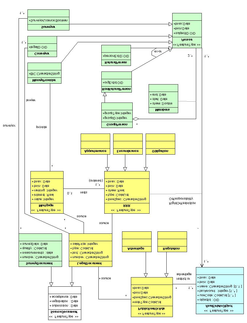
30
31
32 Core Cadastral Domain Model: Geometry Real estate object with specialisations, e.g. parcel, parcel-complex, volume property, restriction area, point parcel, apartment unit, based on topological structure or not Agregations like parcels set, parcel complex, apartment complex Link to surveying and survey documentation Link to OGC standards (Nodes, Edges and Faces)
33 Core Cadastral Domain Model: Legal-administrative RRR is an association class between Person and RealEstateObject Mortgage, restriction and RRR are based on legal documents or decisions Person are specialised as natural or non natural Surveyor, conveyor and money provider are included, specialisations of the Persons class A RRR can be temporal
34 FIG Cadastre 2014 (Kaufmann, Steudler) Legal Topics: Land Object Boundaries: Rightful Claimants:... Resource Exploitation Collective Rights Water Protection Indigenous Rights Environment Protection Land Use Planning Land Property Shelter and Housing Natural Resources Natural Land Objects Common reference system... Chartered company Corporation Society Tribe, Clan Society Society Private Land Owners House owners Society Society
35 FIG Cadastre 2014 approach is integrated Cadastre 2014 is a generic, very good, abstract set of guidelines (compare to ISO standard, or OGC abstract specification) CCDM is refined into a more specific model using UML (compare OGC implementation specification) CCDM is based on OGC and ISO TC211 standards CCDM will enable interoperable implementations and provide foundation for database structure (DBMS DDL/SQL), information exchange format (XML/GML)
36 Boundary of the system outside (in this moment): Geology, geo-technical, soil Pipelines and cables Polluted area registers Mining right registers Cultural history (Religious) monuments Ship/airplane (car) registers
37 Aspects not yet covered Processes: how to maintain consistency between two related distributed systems in case of updates: the cadastral production process depends on availability and quality of data at remote servers (e.g. Persons in population database) Catalogues with 'types of right (per country?) Further modelling of cadastral survey Inclusion of a range of spatial units Generation of a full XML/GML schema Test with real data, in EULIS context Harmonise with other domain models, e.g. Topography, Water, Utility Networks
38 Agenda Introduction Cadastral Data Generic Cadastral Domain Model Conclusions
39 Conclusion Current proposal is under development, workshops, reviews, etc More attention to process side (in addition to data side) Not only the model itself is important, but the fact that there is consensus (also important role of industry)
40 Thank you
41 Model independent of organisation, examples of actual registrations Deeds Land Registry, Public Registers Cadastral Register Cadastral Map Cadastre/Private Surveyor Field Sketches
42 Customer Groups: cadastral data exchange Citizens Emergency services Planners Municipalities Private Surveyors Utilities Cadastre Conveyors Ministeries Housing association Real Estate Agents Financial Lawyers/ institutions Accountants
43 History and dynamic aspects, data Two modeling approaches for discrete changes: 1. Event based modeling: transactions as entity, start state is know, changes are known 2. State based modeling: states are modeled explicitly, objects have 2 dates (begin/end) In our model hybrid approach: documents represent the transactions, but also all the states are kept tmin/tmax attributes inherited from root objects No explicit parent-child relationships (lineage), implicit
44 History and dynamic aspects, processes Other type of UML diagram used to model the processes (e.g. use case, sequence, collaboration, state or activity diagrams). Example of splitting a parcel described in a state diagram

45 3D example in NL, current solution 3D Parcel of one building is subdivided into 3 parts with different admin tags

46 Registration of 3D object (tunnel)


47 Another 3D factual situation (NL)

48 3D apartement complex on 2D parcels
Towards the Introduction of Workflow Management at the Netherlands Cadastre. WFM at NL Cadastre. Basic datamodel. Den Bosch G 7625
 Towards the Introduction of Workflow Management at the Netherlands Cadastre Berry van Osch Christiaan Lemmen Wednesday, May 26 2004 FIG Working Week Athens WFM at NL Cadastre Basic datamodel Nothing really
Preprint.
 http://www.diva-portal.org Preprint This is the submitted version of a paper presented at 10th EC GI & GIS Workshop, ESDI State of the Art, Warsaw, Poland, 23-25 June 2004. Citation for the original published
Cadastral Systems IV
 Computers, Environment and Urban Systems 30 (2006) 523 528 www.elsevier.com/locate/compenvurbsys Editorial Cadastral Systems IV This is the fifth of a series of theme issues on Cadastral Systems in Computers,
The Challenge to Implement International Cadastral Models Case Finland 1
 The Challenge to Implement International Cadastral Models Case Finland 1 Tarja MYLLYMÄKI and Tarja PYKÄLÄ, Finland Key words: cadastre, modelling, LADM, INSPIRE SUMMARY Efforts are currently made to develop
REGISTRATION OF PROPERTIES IN STRATA
 REGISTRATION OF PROPERTIES IN STRATA REPORT ON THE WORKING SESSIONS INTRODUCTION A cadastre is usually, and in most countries, a parcel-based, and up-to-date land information system containing records
The European Common Agricultural Policy (CAP) after 1992
 after 1992") On the Level of Cooperation between Agricultural & Cadastral Parcel Registration Halil Ibrahim INAN (presenter) & Tahsin YOMRALIOGLU, Turkey Peter van OOSTEROM & Jaap ZEVENBERGEN, The Netherlands 1 OTB
On the Level of Cooperation between Agricultural & Cadastral Parcel Registration Halil Ibrahim INAN (presenter) & Tahsin YOMRALIOGLU, Turkey Peter van OOSTEROM & Jaap ZEVENBERGEN, The Netherlands 1 OTB
Agenda. Clarissa Augustinus, UN-HABITAT and Christiaan Lemmen and Peter van Oosterom, The Netherlands 15. Billion people URBAN 60%
 Social Tenure Domain Model (STDM) Requirements from the perspective of Pro-Poor Land Management Clarissa Augustinus, Chief, Land and Tenure Section, UN-HABITAT Christiaan Lemmen, ITC/Kadaster, The Netherlands
Basic view. View of the report View of Cadastre 2014
 Basic view Standardized core cadastral domain model serves to: Avoid reinventing and reimplementing th same functionality again and again Enabel involved parties to communicate based on an shared ontology
Advances in Modern Land Administration Cadastre 2014 in the Year 2006
 Advances in Modern Land Administration Cadastre 2014 in the Year 2006 Winfried HAWERK, Germany Key words: E-Land Administration, IT renewal strategies SUMMARY FIG Commission 7 Working Group 7.3 deals with
Further Progress in the Development of a Core Cadastral Domain Model
 Further Progress in the Development of a Core Cadastral Domain Model Christiaan LEMMEN and Peter VAN OOSTEROM, the Netherlands Key words: Standardization, Cadastral Systems, Cadastral Domain, Open GIS
Hungarian Cadastre and its relation to LADM
 Hungarian Cadastre and its relation to LADM Gyula IVÁN CLGE General Assembly 22 March 2013, Budapest, HUNGARY Content Historical background Evolution of Cadastral modeling in Hungary LADM issues Conclusion
LAND ADMINISTRATION IN LITHUANIA: CHALLENGES AND PERSPECTIVES
 UNECE WPLA Workshop Influence of Land Administration on People and Business, Cavtat, Croatia, October 2-3, 2008 LAND ADMINISTRATION IN LITHUANIA: CHALLENGES AND PERSPECTIVES Kestutis Sabaliauskas, Director
INSPIRE Thematic Working. Cadastral parcels. September 2008
 INSPIRE Thematic Working Cadastral parcels September 2008 The INSPIRE context The INSPIRE Directive Its aim is to build the INfrastructure for Spatial InfoRmation in Europe The INSPIRE Directive has been
EXPLORING OPTIONS FOR STANDARDISATION OF PROCESSES AND TRANSACTIONS IN LAND ADMINISTRATION
 EXPLORING OPTIONS FOR STANDARDISATION OF PROCESSES AND TRANSACTIONS IN LAND ADMINISTRATION CHRISTIAAN LEMMEN (1),(2), EVA-MARIA UNGER (2), PETER VAN OOSTEROM (3), MOHSEN KALANTARI (4) AND KEES DE ZEEUW
A New Vision on Cadastral Data Model
 Mohsen KALANTARI, Abbas RAJABIFARD, Jude WALLACE and Ian P. WILLIAMSON, Australia Key words: Land administration, cadastre, land parcel, legal property object, interoperability SUMMARY Land administration
LADM-based Crowdsourced 3D Cadastral Surveying Potential and Perspectives
 National Technical University Of Athens School of Rural and Surveying Engineering LADM-based Crowdsourced 3D Cadastral Surveying Potential and Perspectives Maria Gkeli, Surveying Engineer, PhD student
ABSTRACT Land Administration System in Lithuania
 ABSTRACT Land Administration System in Lithuania 1. General introduction to the Lithuanian Land Administration System and State Enterprise Centre of Registers ( shortly SECR) Lithuania has established
Challenges for the multi purpose cadastre
 Jens RIECKEN, Markus SEIFERT, Germany Key words: Multi purpose cadastre, 3d-cadastre, land use, SDI, solar cadastre SUMMARY Over the past 30 years, with the progress of information technologies the development
Challenge to Implement International Cadastral Models Case Finland
 FIG Articleof the Month April 20 Challenge to Implement International Cadastral Models Case Finland Tarja Myllymäki and Tarja Pykälä 200-04-5 The topics are In European level INSPIRE Experiences, similarities,
Topographic Signs Important Context of 3D Cadastre
 STATE GEODETIC ADMINISTRATION Gruška 20,10 000 Zagreb, Croatia Delft University of Technology Faculty of Architecture and the Built Environment Department OTB GIS Technology Section Topographic Signs Important
LIS a motivation for SDI initiative
 Eric Mwaikambo Ardhi University Dar es Salaam Tanzania Overview Status of LIS in Tanzania Relationship between SDI and LIS Spatial Standards LIS a motivation for SDI initiative Conclusion & Recommendations
Cadastral Parcels in INSPIRE. Lisbon, 27 February 2013
 Cadastral Parcels in INSPIRE Lisbon, 27 February 2013 Dominique.laurent@ign.fr Plan INSPIRE context The modeling approach for theme Cadastral Parcels Implementation of INSPIRE theme Cadastral Parcels Context
From LADM/STDM to a spatially enabled society: a vision for Harry UITERMARK, Peter VAN OOSTEROM, Jaap ZEVENBERGEN and Christiaan LEMMEN
 From LADM/STDM to a spatially enabled society: a vision for 2025 Harry UITERMARK, Peter VAN OOSTEROM, Jaap ZEVENBERGEN and Christiaan LEMMEN Introduction (1) Vision is a co-production Founding fathers
A Review and Perspective on Parcel Data Models for Urban Planning
 A Review and Perspective on Parcel Data Models for Urban Planning Yiqiang Ouyang Prof. Dr. Ilir Bejleri Department of Urban and Regional Planning University of Florida June 19-21, 2010 1 Content 1. Introduction
Cadastre A Vision on Future Cadastral Systems
 Cadastre 2014 - A Vision on Future Cadastral Systems Jürg Kaufmann - 1 - CONTENTS ABOUT FIG ENVIRONMENT FOR THE DEVELOPMENT OF CADASTRE 2014 DEVELOPMENT OF CADASTRE 2014 PRINCIPLES OF CADASTRE 2014 EFFECTS
Object Oriented Unified Real Estate Registry for a Good Spatial Data Management
 Object Oriented Unified Real Estate Registry for a Good Spatial Data Management Gyula IVÁN Gábor SZABÓ Zoltán WENINGER Institute of Geodesy, Cartography and Remote Sensing (FÖMI), Hungary Workshop on e-governance,
Utilizing 3D Building and 3D Cadastre Geometries for Better Valuation of Existing Real Estate
 Utilizing 3D Building and 3D Cadastre Geometries for Better Valuation of Existing Real Estate Umit ISIKDAG Beykent U., Turkey Mike HORHAMMER Oracle, USA Sisi ZLATANOVA, Peter VAN OOSTEROM TU Delft, The
A Complete, Free Solution for Cadastral Map Management
 A Complete, Free Solution for Cadastral Map Management Gyula IVÁN Institute of Geodesy, Cartography & Remote Sensing (FÖMI) HUNGARY FIG Commission 7, Annual Meeting 11-15 September 2008., Verona, ITALY
Legal Aspects of 3D Property Rights, Restrictions and Responsibilities in Greece and Cyprus
 Legal Aspects of 3D Property Rights, Restrictions and Responsibilities in Greece and Cyprus Efi DIMOPOULOU, National Technical University of Athens, Greece and Elikkos ELIA, Cyprus Department of Lands
The ISO/TC 211 Land Administration Domain Model (LADM)
") Geographic information/geomatics The ISO/TC 211 Land Administration Domain Model (LADM) Harry Uitermark/Editor LADM Kadaster/ITC, The Netherlands International Organization for Standardization (ISO) A
Geographic information/geomatics The ISO/TC 211 Land Administration Domain Model (LADM) Harry Uitermark/Editor LADM Kadaster/ITC, The Netherlands International Organization for Standardization (ISO) A
From LADM/STDM to a spatially enabled society: a vision for Harry UITERMARK, Peter VAN OOSTEROM, Jaap ZEVENBERGEN and Christiaan LEMMEN
 From LADM/STDM to a spatially enabled society: a vision for 2025 Harry UITERMARK, Peter VAN OOSTEROM, Jaap ZEVENBERGEN and Christiaan LEMMEN Introduction (1) Presentation is a coproduction Founding fathers
The Multi Purpose Cadastre, a network approach
 The Multi Purpose Cadastre, a network approach Peter Laarakker, Kadaster NL 1 Content 1. Introduction 2. Multi purpose cadastre 3. Definitions 4. Cadastral boundaries 5. Real property right 6. Conclusions
Towards LADM Country Cadastral Profile Case Poland
 Towards LADM Country Cadastral Profile Case Poland Jarosław BYDŁOSZ, Poland Key words: LADM, Country Profile, Cadastre, Poland SUMMARY The Geographic Information - Land Administration Domain Model was
Aspect of preliminary activities in the function of supporting NSDI
 Sonja DIMOVA, Republic of Macedonia Key words: e-governance, geospatial data, NSDI, INSPIRE, metadata SUMMARY The successful establishment of the NSDI in the true sense of the word cannot be performed
COMMISSION 7 CADASTRE AND LAND MANAGEMENT WORK PLAN
 Appendix to item 34.7 FIG Congress in Washington, 19-26 April 2002 COMMISSION 7 CADASTRE AND LAND MANAGEMENT WORK PLAN 2002 2006 1. Title Cadastre and Land Management 2. Terms of Reference Commission 7
REFORM OF LAND CADASTRE IN LITHUANIA
 REFORM OF LAND CADASTRE IN LITHUANIA Romualdas KASPERAVICIUS, Lithuania Key words: ABSTRACT Main aim for every Government is to create legal, financial and organisational circumstances for real property.
Cadastral Template 2003
 PCGIAP-Working Group 3 "Cadastre" FIG-Commission 7 "Cadastre and Land Management" Cadastral Template 2003 The establishment of a cadastral template is one of the objectives of Working Group 3 "Cadastre"
Recent Developments in Use and Dissemination of Geospatial Data in Germany - Example Lower Saxony
 Recent Developments in Use and Dissemination of Geospatial Data in Germany - Example Lower Saxony Conference Permanent Committee on Cadastre Lithuanian Presidency Vilnius, 22 October 2013 Peter Creuzer
Ownership Data in Cadastral Information System of Sofia (CIS Sofia) from the Available Cadastral Map
 from the Available Cadastral Map") Ownership Data in Cadastral Information System of Sofia (CIS Sofia) from the Available Cadastral Map Key words: ABSTRACT Lydmila LAZAROVA, Bulgaria CIS Sofia is created and maintained by GIS Sofia ltd,
Ownership Data in Cadastral Information System of Sofia (CIS Sofia) from the Available Cadastral Map Key words: ABSTRACT Lydmila LAZAROVA, Bulgaria CIS Sofia is created and maintained by GIS Sofia ltd,
Digitalisation of the Real Property Rights Towards Spatially enabled E-Government
 Digitalisation of the Real Property Rights Towards Spatially enabled E-Government Lise Schroeder, Bent Hulegaard Jensen, Esben Munk Soerensen & Line Hvingel Istanbul, Turkey 25 june 201 Overview Introduction
Value Chain Mapping. 3D Cadastre and Valuation The Added Value of 3D Geo-information Richard Witmer, Kadaster NL, 30 March 2017
 Value Chain Mapping 3D Cadastre and Valuation The Added Value of 3D Geo-information Richard Witmer, Kadaster NL, 30 March 2017 Agenda Purpose: why look at 3D cadastre and valuation? Approach: what we did.
The Development of the Austrian Cadastre from Documentation to an Integrated Planning and Decision Support System
 The Development of the Austrian Cadastre from Documentation to an Integrated Planning and Decision Support System WPLA - Working Party on Land Administration 15-17 October 2014, Vienna, Austria Wernher
BULGARIAN CADASTRE A GUARANTEE FOR THE OWNERSHIP RIGHTS IN IMMOVABLE PROPERTIES
 4 TH INTERNATIONAL CONFERENCE RECENT PROBLEMS IN GEODESY AND RELATED FIELDS WITH INTERNATIONAL IMPORTANCE February 28 - March 2, 2007, Inter Expo Centre, Sofia, Bulgaria BULGARIAN CADASTRE A GUARANTEE
On the Level of Cooperation between Agricultural and Cadastral Parcel Registration
 On the Level of Cooperation between Agricultural and Cadastral Parcel Registration Halil Ibrahim INAN and Tahsin YOMRALIOGLU, Turkey; Peter van OOSTEROM and Jaap ZEVENBERGEN, the Netherlands Key words:
Support to Implementation of Multipurpose Cadastral Information system in Vietnam
 Support to Implementation of Multipurpose Cadastral Information system in Vietnam Lennart JOHANSSON and Per SÖRBOM, Sweden Key words: Land Registration, Land Information, Land Administration, SWOT analyse,
Progress Report on Green Paper. Dr. Paddy Prendergast. on behalf of the. IIS Commission on Land Registration
 Progress Report on Green Paper By Dr. Paddy Prendergast on behalf of the IIS Commission on Land Registration Paddy Prendergast - Chair Brendan Sweeny - Hempenstall Surveys Paul Corrigan - P Corrigan Associates
How Dutch registrars use PLR information to enrich the data from Cadastre
 How Dutch registrars use PLR information to enrich the data from Cadastre 12-11-2015 Presentation topics Introduction Two methods of registration of PL Restrictions Shaping the future method, current discussions
Commission 7 Cadastre and Land Administration. Work Plan
 Commission 7 Cadastre and Land Administration Work Plan 2011 2014 Appendix to item 17.7 1. Title Cadastre and Land Administration 2. Terms of Reference Commission 7 deals with land administration and land
Content and message. 3D registration of real property in Denmark. Content and message. Introduction. Cadastral register
 Content and message 3D of real property in Denmark Jantien Stoter Section GIS technology, Delft University of Technology (NL) Esben Munk Sørensen and Lars Bodum GeoInformation and MediaTechnologi, Aalborg
THE DEVELOPMENT OF CADASTRAL DOMAIN MODEL ORIENTED AT UNIFIED REAL ESTATE REGISTRATION OF CHINA BASED ON ONTOLOGY
 ISPRS Annals of the Photogrammetry, Remote Sensing and Spatial Information Sciences, Volume I-2, 202 XXII ISPRS Congress, 25 August 0 September 202, Melbourne, Australia THE DEVELOPMENT OF CADASTRAL DOMAIN
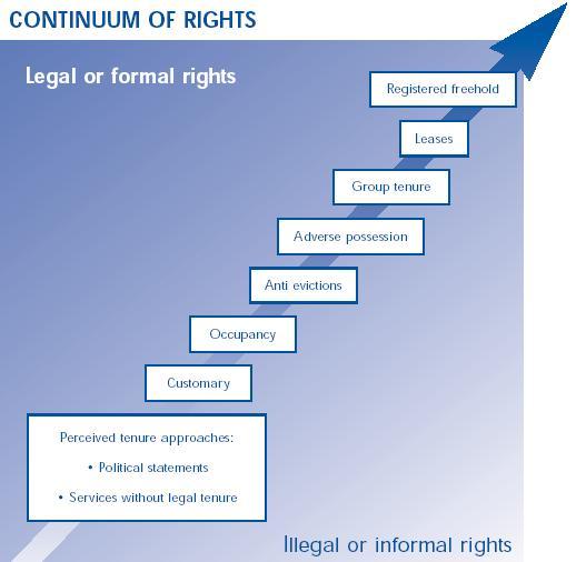
The LADM and the Continuum of Land Rights
 CheeHai TEO, Malaysia and Christiaan Lemmen, the Netherlands Key words: LADM, Continuum of Land Rights, Voluntary Guidelines, Spatial Enabled Societies SUMMARY The development of the Land Administration
Standardization in the Cadastral Domain. Sub Working Group 1: Legal Aspects
 Standardization in the Cadastral Domain Sub Working Group 1: Legal Aspects Framework 10 participants 8 countries 2 sessions Updates from the different countries (mainly as to the legal aspects of cadastre)
CADASTRE 2014: New Challenges and Direction
 CADASTRE 2014: New Challenges and Direction Anna KRELLE and Abbas RAJABIFARD, Australia Key words: Cadastre, Cadastre 2014, Land Administration SUMMARY Land and land related activities form part of the
Questionnaire 3D-Cadastres: status September 2014 Norway
 Questionnaire 3D-Cadastres: status September 2014 rway This questionnaire is an activity of the FIG working group 3D-Cadastres 2014-2018. The purpose of the survey is to make a world-wide inventory of
Object Oriented Unified Real Estate Registry for a Good Spatial Data Management
 Object Oriented Unified Real Estate Registry for a Good Spatial Data Management Gyula IVÁN Gábor SZABÓ Zoltán WENINGER, Hungary Key words: Cadastre, Land Administration, GIS SUMMARY The IT developments
HOUSING AND PROPERTY MARKET IN LITHUANIA CONTENTS
 HOUSING AND PROPERTY MARKET IN LITHUANIA Kęstutis Sabaliauskas, Director General State Enterprise Centre of Registers, Lithuania Kestutis.Sabaliauskas@registrucentras.lt CONTENTS Legal environment Real
SECTOR PUBLIC CADASTRES AND REGISTERS MARKET PARTICIPANTS
 E-SERVICES TO CITIZENS, GOVERNMENT AND BUSINESSES. LITHUANIA EXPERIENCE Arvydas Bagdonavičius State Enterprise Centre of Registers Arvydas.Bagdonavicius@registrucentras.lt REGISTERS AND IS MANAGED BY THE
Land and Geographic Information, an Important Part of the Infrastructure in Sweden
 Land and Geographical Information Land and Geographic Information, an Important Part of the Infrastructure in Sweden Land and Geographic Information, an Important Part of the Infrastructure In Sweden Bo
A CADASTRAL GEODATA BASE FOR LAND ADMINISTRATION USING ARCGIS CADASTRAL FABRIC MODEL A CASE STUDY OF UWANI ENUGU, ENUGU STATE, NIGERIA
 A CADASTRAL GEODATA BASE FOR LAND ADMINISTRATION USING ARCGIS CADASTRAL FABRIC MODEL A CASE STUDY OF UWANI ENUGU, ENUGU STATE, NIGERIA BY Ndukwu, Raphael. Ike Department of Geoinformatics & Surveying University
Saulius Milevičius, Lithuanian Surveyors Association Head of the Internet Map Application Designing Group SE Centre of Registers
 LITHUANIAN EXPERIENCE IN CADASTRE Saulius Milevičius, Lithuanian Surveyors Association Head of the Internet Map Application Designing Group SE Centre of Registers Jolanta Česnauskienė, Jolanta Česnauskienė,
Test and Implementation of DATR System in Hungary
 Test and Implementation of DATR System in Hungary, Hungary Key words: unified land registry, cadastral map, Hungary SUMMARY During the last years there has been an important development in the Hungarian
Spatial Data Infrastructure in Sweden
 Spatial Data Infrastructure in Sweden Hans-Erik WIBERG, Sweden Key words: ABSTRACT Sweden was one of the first countries to address Data Infrastructure matters and have during several decades developed
Profile Definition for a. Standardized Cadastral Model
 Profile Definition for a www.caris.com Standardized Cadastral Model Hugh Aste, Rick Nyarady & Greg Mulholland Outline Our interest in the Core Cadastre Domain Model Identification of a practical need for
MASS VALUATION DATA FOR GOVERNMENT, CITIZENS AND BUSINESS
 Permanent Committee on Cadastre in the European Union Lithuanian Presidency PCC Conference 22-23 October 2013, Vilnius MASS VALUATION DATA FOR GOVERNMENT, CITIZENS AND BUSINESS Arvydas Bagdonavičius Deputy
Surveying in Austria. Congress Maanmittauspäivät Seinäjoki, 20 th March 2014
 Surveying in Austria Congress Maanmittauspäivät Seinäjoki, 20 th March 2014 Topics Facts, figures Organisational issues of surveying Role of the BEV Products, services The Cadastre Surveying Education
A MODULAR STANDARD FOR THE CADASTRAL DOMAIN
 A MODULAR STANDARD FOR THE CADASTRAL DOMAIN Christiaan Lemmen 1, Paul van der Molen 1, Peter van Oosterom 2, Hendrik Ploeger 2, Wilko Quak 2, Jantien Stoter 2, and Jaap Zevenbergen 2 1 Dutch Cadastre,
Building a national SDI. Approach and strategy in The Netherlands
 Agenda 1. NSDI vision and implementation strategy 2. NSDI playing field 3. Standards framework for the NSDI 4. National SDI components for IM Information model public safety SDI Portal for public safety
A new era: Dynamic Information Management
 A new era: Dynamic Information Management Professional and Institutional Developments Kees de Zeeuw MSc Director Kadaster International The Netherlands Affiliate member s perspective 45 affiliates from
Quality Improvement of the Real Estate Cadastre in Serbia
 , Serbia Key words: quality improvement, real estate information, quality assurance, Serbia SUMMARY The concept of cadastral modernization in the Republic of Serbia was defined in 1992, and it is being
NEW CADASTRAL APPROACH FOR SUSTAINABLE DEVELOPMENT IN MULTILAYER BUILDING
 NEW CADASTRAL APPROACH FOR SUSTAINABLE DEVELOPMENT IN MULTILAYER BUILDING Tan Liat Choon and Khadijah Binti Hussin Department of Land Administration and Development, Universiti Teknologi Malaysia, Johor,
The computerised land reallotment process in Turkey and the Netherlands in multi-purpose land consolidation projects
 The computerised land reallotment process in Turkey and the Netherlands in multi-purpose land consolidation projects FIG Conference, 15 April 2010, Sydney Louisa J. M. Jansen (Netherlands), Mustafa Karatas,
UN-GGIM Expert Group on Land Administration and Management Expert Group Meeting, Delft, The Netherlands 14 & 15 March, 2017
 UN-GGIM Expert Group on Land Administration and Management Expert Group Meeting, Delft, The Netherlands 14 & 15 March, 2017 BACKGROUND DOCUMENT The Delft Expert Group Meeting This two-day meeting of the
CADASTRE AND LAND REGISTER Following up their relationship
 CADASTRE AND LAND REGISTER Following up their relationship Jorge López ELRA Barcelona, 16th May 2014 Principles of relationship cadastre-land register Description of properties ( A ): huge interest Ownership
Integrated Land Information Services in Hungarian Land Administration
 , Hungary Key words: key words, theme, etc. SUMMARY The Unified Hungarian Land Registry, in which cadastral mapping and land registry belong to the same organization (Land Office Network), has been operating
The Contribution of Forest Owners Associations for the Forest Cadastre Implementation. João Gaspar Ana Navarro Ferreira PORTUGAL
 The Contribution of Forest Owners Associations for the Forest Cadastre Implementation João Gaspar Ana Navarro Ferreira PORTUGAL Motivation Lack of forestry cadastre; Unify all FOAs databases with common
Development of 3D Cadastre in Hungary
 Development of 3D Cadastre in Hungary András OSSKÓ Gyula IVÁN CLGE General Assembly 22 March 2013, Budapest, HUNGARY Content Introduction Problems in development of 3D cadastre and registration Hungarian
Incorporating Sustainable Development Objectives into ICT Enabled Land Administration Systems - Case Study Switzerland
 EXPERT GROUP MEETING ON INCORPORATING SUSTAINABLE DEVELOPMENT OBJECTIVES INTO ICT ENABLED LAND ADMINISTRATION SYSTEMS 9-11 November 2005, Centre for Spatial Data Infrastructures and Land Administration
Advanced Principles of 3D Cadastral Data Modelling. 2 nd International Workshop on 3D Cadastres 16 th 18 th November 2011
 Advanced Principles of 3D Cadastral Data Modelling 2 nd International Workshop on 3D Cadastres 16 th 18 th November 2011 Agenda Introduction to the project Drivers for land and property information in
Standardization of the LADM Modelling of non-formal RRR
 Standardization of the LADM Modelling of non-formal RRR Jesper M. Paasch (Lantmäteriet), Peter van Oosterom (TU Delft), Christiaan Lemmen (Kadaster) and Jenny Paulsson (KTH Royal Institute of Technology)
The Multipurpose Hungarian Unified Land Registry System
 The Multipurpose Hungarian Unified Land Registry System András Osskó FIG Working Week Integrating Generation Stockholm, Sweden 14-19 June 2008 Republic of Hungary is located in Central Europe Neighbouring
Securing Land Rights for Broadband Land Acquisition for Utilities in Sweden
 Securing Land Rights for Broadband Land Acquisition for Utilities in Sweden Marija JURIC and Kristin LAND, Sweden Key words: broadband, land acquisition, cadastral procedure, Sweden SUMMARY The European
The Verification of the Modernization of the Real Estate Cadastre in the Context of the Quality of Cadastral Data Case Study
 Environmental Engineering 10th International Conference eissn 2029-7092 / eisbn 978-609-476-044-0 Vilnius Gediminas Technical University Lithuania, 27 28 April 2017 Article ID: enviro.2017.218 http://enviro.vgtu.lt
Greetings from Denmark. Property Rights, Restrictions and Responsibilities - A Global Land Management Perspective. Wonderful Copenhagen
 Property Rights, Restrictions and Responsibilities - A Global Land Management Perspective Greetings from Denmark 43,000 sq km Prof. Stig Enemark President Aalborg University, Denmark Aalborg Copenhagen
Low Cost Cadastral Data Acquisition? ANNUAL WORLD BANK CONFERENCE ON LAND AND POVERTY World Bank - Washington DC April 23-26, 2012
 Low Cost Cadastral Data Acquisition? ANNUAL WORLD BANK CONFERENCE ON LAND AND POVERTY World Bank - Washington DC April 23-26, 2012 Christiaan Lemmen, Co Meijer, Jaap Zevenbergen, Rohan Bennett Abstract
Cadastre 2020 a Vision for a Future Cadastral System in Poland
 Cadastre 2020 a Vision for a Future Cadastral System in Poland Wojciech Wilkowski, Marcin Karabin, Poland Key words: model of cadastre, cadastral system, land register SUMMARY The paper presents results
Commission 7, Land Administration and IT. Paul van der Molen INTERNATIONAL INSTITUTE FOR GEO-INFORMATION SCIENCE AND EARTH OBSERVATION
 Commission 7, Land Administration and IT Paul van der Molen INTERNATIONAL INSTITUTE FOR GEO-INFORMATION SCIENCE AND EARTH OBSERVATION FIG Commission 7 on cadastre and land management Study Visits (e.g.
Germany on the way to a 4D-Cadastre
 Germany on the way to a 4D-Cadastre Dr. Jens Riecken (DVW Vicepresident), Ulrich Gruber, Dr. Markus Seifert (DVW WG Geoinformation) TS 9.1 4D Cadastre, Land Domain Models & Concepts 1 Content About my
Design and Determine 3D Cadastral Systems: A Case Study of Turkey Hicret GURSOY SURMENELI* and Mehmet ALKAN* (Turkey)
") Design and Determine 3D Cadastral Systems: A Case Study of Turkey Hicret GURSOY SURMENELI* and Mehmet ALKAN* (Turkey) *Yildiz Technical University, Civil Engineering Faculty, Department of Geomatics CONTENTS
Design and Determine 3D Cadastral Systems: A Case Study of Turkey Hicret GURSOY SURMENELI* and Mehmet ALKAN* (Turkey) *Yildiz Technical University, Civil Engineering Faculty, Department of Geomatics CONTENTS
THINKING OUTSIDE THE TRIANGLE TAKING ADVANTAGE OF MODERN LAND MARKETS. Ian Williamson
 THINKING OUTSIDE THE TRIANGLE TAKING ADVANTAGE OF MODERN LAND MARKETS Ian Williamson Professor of Surveying and Land Information Head, Department of Geomatics Director, Centre for Spatial Data Infrastructures
Annual Meeting 2006 SLOVENIA, BLED RASAS GOFMANAS JAUNIUS GRIGAS RIMANTAS RAMANAUSKAS KESTUTIS TRECIOKAS
 Annual Meeting 2006 SLOVENIA, BLED LAND ADMINISTRATION IN LITHUANIA RASAS GOFMANAS JAUNIUS GRIGAS RIMANTAS RAMANAUSKAS KESTUTIS TRECIOKAS ADMINISTRATIVE STRUCTURE OF LITHUANIA HISTORY OF LAND ADMINISTRATION
Social and Economic Benefits of Good Land Administration (Second Edition)
") United Nations Economic Commission for Europe Working Party on Land Administration Social and Economic Benefits of Good Land Administration (Second Edition) Published by HM Land Registry, London, on behalf
United Nations Economic Commission for Europe Working Party on Land Administration Social and Economic Benefits of Good Land Administration (Second Edition) Published by HM Land Registry, London, on behalf
Lessons for federated countries that have state land registries the Australian experience
 Lessons for federated countries that have state land registries the Australian experience Ian Williamson Centre for SDI and Land Administration Department Infrastructure Engineering University of Melbourne
A Geocoded Cadastral Fabric as a Precondition for a Sustainable Land Management System
 A Geocoded Fabric as a Precondition for a Sustainable Land Management System Gottfried KONECNY, Germany; J.P. LAUZON, Canada; Abdul Salam MOHAMMED, India Key words: SDI,, Parcel Boundaries, GPS-GNSS, Land
Reliability of the Italian cadastral system data quality and improvement prospects
 Reliability of the Italian cadastral system data quality and improvement prospects Eng. Franco MAGGIO (Central Director for Cadastral, Cartographic and Land Registration Services) Eng. Arturo ANGELINI
Property Transactions in the Digital Age. The Property Cadastre in the Context of Spatial. Dr. Jens Riecken, NRW Ministry of the Interior
 Property Transactions in the Digital Age The Property Cadastre in the Context of Spatial Data Infrastructure (SDI) Dr. Jens Riecken, NRW Ministry of the Interior Property Transactions in the Digital Age
Cadastral Framework Standards
 Cadastral Framework Standards The goal of the Data Standards and Recommendations Committee is to provide recommendations and guidelines to Indiana GIS user communities to facilitate the collection, maintenance
LADM Implementation Prototype for 3D Cadastre Information System of Multi-Level Apartment in Indonesia
 LADM Implementation Prototype for 3D Cadastre Information System of Multi-Level Apartment in Indonesia Yanto Budisusanto Trias Aditya Rochmad Muryamto IDEA Limitations of land supply for infrastructure
3D aspects of cadastral data modelling
 3D aspects of cadastral data modelling Jantien E. Stoter and Hendrik D. Ploeger Department of Geodesy, Faculty of Civil Engineering and Geosciences Delft University of Technology, The Netherlands (j.e.stoter
Extending Land Administration Domain Models with a Goal Perspective
 Christophe Ponsard 1 and Mounir Touzani 2 1 CETIC Research Centre, Charleroi, Belgium 2 Académie de Toulouse, Toulouse, France Keywords: Abstract: Cadastral System, Land Registration, Spatio-temporal Modelling,
Surveyors Qualifications
 Surveyors Qualifications Præludium Surveyors Qualifications Lars Jansson, Director Lantmäteriet Henning Elmstrøm, President DdL 1 Agenda 1. Introduction 2. Basic framework conditions for cadastral systems