Design and Determine 3D Cadastral Systems: A Case Study of Turkey Hicret GURSOY SURMENELI* and Mehmet ALKAN* (Turkey)
|
|
|
- Imogene Fields
- 5 years ago
- Views:
Transcription
1 Design and Determine 3D Cadastral Systems: A Case Study of Turkey Hicret GURSOY SURMENELI* and Mehmet ALKAN* (Turkey) *Yildiz Technical University, Civil Engineering Faculty, Department of Geomatics
2 CONTENTS THE NECESSITY OF 3D-4D CADASTRE PURPOSE of the STUDY BACKROUND of the TURKEY CADASTRAL SYSTEM - Evaluation of Turkey Cadastral System concerning legal and cadastral objects - Evaluation of existing projects in Turkey THE TURKEY CADASTRAL SYSTEM PROFILE, BASED ON LADM CONCLUSION
. However, the definitions of cadastre conflicts with existing surveying systems. Because the physical world is four dimensions.")
3 THE NECESSITY OF 3D-4D CADASTRE Various categorizations and definitions have been made for the cadastre taking into consideration criteria such as priority purposes, types of registered rights, techniques used for collecting data (FIG, 1995). However, the definitions of cadastre conflicts with existing surveying systems. Because the physical world is four dimensions. These are horizontal (x), (y), vertical (z) and time (t) dimensions.
4 THE NECESSITY OF 3D-4D CADASTRE These include Bogor Declaration, Cadastre 2014, Bathurst Declaration, European Union Cadastre Congress and Cadastre 2034 Vision. These studies jointly emphasize the following issues. To be a property owner and create a cadastral system that is managed in a sustainable way. In addition, modern cadastre related infrastructures should be developed. A cadastre system that is accessible, easily visualized, easily understood and used will be created. It is to establish a cadastre system linked to wider legal and social interests on the land. A cadastral system with knowledge of rights, restrictions and responsibilities related to registered or unregistered land will be established. A three-dimensional, dynamic and accurately measured digital cadastre will be introduced. An integrated cadastre system based on common standards will be established.
5 PURPOSE of the STUDY The main aim of our study is to analyze the our existing cadastral system within the scope of 3D Cadastre. In this context, Firstly the legal legislation was examined. Then the projects developed in our country were evaluated. Cadastral objects recorded in our existing cadastral system have been introduced. Our existing cadastral system is modeled based on LADM.
6 Legal aspect CONSTITUION The right of ownership has been defined CIVIL CODE The characteristics, uses and boundaries of the immovable are determined TITLE LAW NO The title regulations have been made CONDOMINIUM LAW NO. 634 Buildings, apartments, offices, shops, cellars, etc. have been defined and allowed to establish independent ownership rights CADASTRE LAW NO. 628 The first cadastral organization was established. Taxation information are archived CADASTRE AND LAND REGISTRY LAW NO Aim; It is defined as to determine the legal and geometrical conditions of the immovable, Thus, taxation has been removed from the duties of the cadastre LAND REGISTRY LAW NO The land registry and cadastre activities are carried out separately. There was a duality CADASTRE LAW NO Land registry and cadastre activities were combined again. Common country coordinate system has been determined The historical process of essential laws in the development of the cadastral system
7 Legal aspect It described how the use of the right to property boundaries can be drawn with Article 35 of the Constitution. According to this; Everyone has the right to ownership and inheritance. These rights may be restricted by law for public good purposes only. The use of the right to property cannot be contrary to the benefit of society. There is no clear statement about the third dimension in the Constitution. There are a number of rights (easement right, floor ownership right, right of passage etc.) in our Constitution concerning the implementation of these rights in three dimensions.
8 Legal aspect The vertical limit on property according to the Civil Code covers all layers above and below the land, so long as the use of property in the land is beneficial. Besides, plants, facilities, and resources on the land are within the limits of the scope of ownership (Article 718 of the Civil Code). According to this definition, the scope of benefit in practice is related to the intended use of property. For example, electrical lines passing over a building puts the building in danger and restricts its use. The subway line may be outside the area that the owner will use in a useful measure, in which case there is no restriction, and no action is taken on the land registry and cadastral map.
9 Legal aspect The cadastre does not deal with immovable properties that are not plotting to cadastral map sheet and not subject to property. Because of this, If the underground lines pass through public roads, streets, parks, parking lots, green spaces, playground, they are only measured and made use of these maps when necessary. The measurement and mapping of underground facilities are not seen as a cadastral activity. This is because they are places without a title under the decision and use of the State according to Article 715 of the Civil Code.
10 Legal aspect Infrastructure facilities are only concerned with the cadastre when passing through the private-registered land. When the transit routes pass through immovables belonging to private or legal persons, either expropriation or easement is established (Civil Code 727; 744). Therefore, Infrastructure facilities are passed from public places (roads, squares, parks, green spaces, children's park, etc.), public land, private and legal persons.


11 Legal aspect The Zafer Bazaar, Owner: Ankara Metropolitan Municipality with , Document number: 9795 Location: Ankara Province, Çankaya District, Zone 3, Volume 2, Pages 127, and is located 7547 cadastral blocks and number of 1 parcel. Zafer Bazaar in Ankara Screen of the parcel questionnaire for Zafer Bazaar Digital cadastral map for Zafer Bazaar

12 Legal aspect Çarşı District, Owner: Firstly the workplace located under the land was registered as a road with the parcel number 125 in the cadastral block number 34 on the name of Rize Municipality. After the completion of the construction of the workplace, this land was registered in the name of the municipality with the new parcel number 149 and rented to the business owner for 49 years. The superficies was established for the workplace under the parcel, and this right was registered to the title. Underground market in Rize
13 Legal aspect The legal definition of 3D objects: 3D objects subject to registration are recorded with easements. The type, scope, and application of 3D RRR s are defined in the Civil Code and Cadastre Law. Although it is possible to register some 3D objects, there is no necessary explanation for 3D objects in the law as a whole. 2D registration is done in the Cadastre Map. Immovables, built on and their rights are registered. Property ownership is registered. Registration is mandatory. Rights that can registered in 3D: Land, parcel, buildings, independent sections and built on are registered. RRR's on the registered objects are recorded. Registered RRR's are represented as 2D in the Cadastral Map. The altitudes are represented as 2D in the cadastral map. Architectural plans have 3D information.
14 Legal aspect Existing 3D objects: Buildings and extensions, Parcels, Servitudes, Condominiums, High voltage lines, Oil and gas pipelines, Pylon sites, Water channels. Registered 3D objects: Buildings and extensions, Parcels, Servitudes, Condominiums, High voltage lines, Oil and gas pipelines, Pylon sites, Water channels. Presentation of 3D objects to cadastral map: 2D
15 Institutional Aspects Ministry of Enviroment and Urbanization (1) General Directorate of Land Registry and Cadastre (1) District Directorate of Land Registry and Cadastre (22) Directorates of Land Registry (970) Directorates of Cadastre (81) Licesed Offices of Surveying and Cadastre (196) General Directorate of Land Registry Cadastre organizational structure
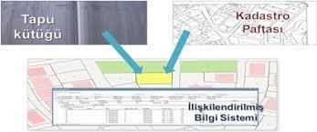
16 Technical Aspects Land Registry and Cadastre Information System (TAKBIS) Spatial Property System (MEGSİS) Land Registry Archive Information System (TARBİS) Civilian and Updating and Digitization of the Administrative Border Project (MIDAS) Land Registry and Cadastre Modernization Project (TKMP) Turkey National Geographic Information System Project (TUCBS) TUSAGA-ACTIVE (Cors-TR) Map Information Bank Project (HBB) Agricultural Reform Application Project (ARIP) Completion of the installation cadastre and 2/B cadastre. The common point of the projects is to manage and share the cadastral data in the digital platform.


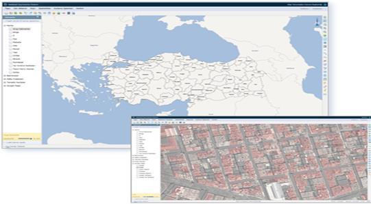
17 TAKBİS Takbis map data structure MEGSIS MEGSIS

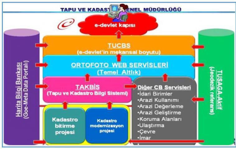
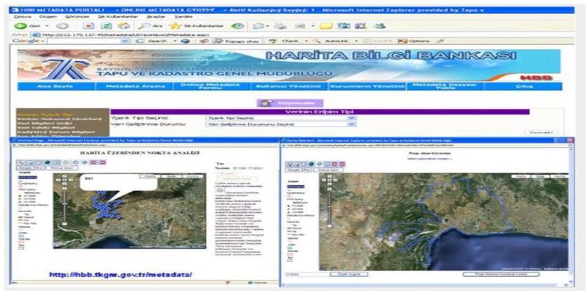
18 TUCBS TUCBS HBB TARBİS


19 THE TURKEY CADASTRAL SYSTEM PROFILE, BASED ON LADM Turkey Country Profile

20 THE TURKEY CADASTRAL SYSTEM PROFILE, BASED ON LADM TC Ownership

21 THE TURKEY CADASTRAL SYSTEM PROFILE, BASED ON LADM TC RRR

22 THE TURKEY CADASTRAL SYSTEM PROFILE, BASED ON LADM TC Real Properties
23 CONCLUSION The purpose of our study is to analyze the situation of our current cadastral system. The historical process of the law enacted for the development of cadastral systems in Turkey is explained. The General Directorate of Land Registry Cadastre, which has a rooted institutional structure, has created the cadastral and topographic cadastral map of the country according to the country coordinate system by Law No In addition, the subdivision of a spatial information system has been formed by specifying the boundaries of immovable properties on land and cadastral maps. Also, the cadastral system and cadastral data have been improved with many projects.
24 CONCLUSION The 2D cadastral parcel is the primary registration unit in Turkey, while some 3D/4D situations given in the text are defined and registered through limited rights, condominium rights, time sharing and other restrictions on intersecting parcels. In Turkey, initiatives projects are developed for providing integration to vision on the future of cadastres. A 2D cadastral system with developed e-government projects has been introduced to excellent condition. Besides, the cadastral system was analyzed with the developed e-government projects. The Turkey. Cadastral system has taken its final form with enacted laws and developed project. However, due to increasing population and intensive construction, the current cadastre system is also inadequate. We need to integrate our existing cadastral system with land management in a universal standard with developing technologies and software.
25 THANKS FOR ATTENTION
Presented at the FIG Congress 2018, May 6-11, 2018 in Istanbul, Turkey
 Presented at the FIG Congress 2018, May 6-11, 2018 in Istanbul, Turkey How to be Created a New Terminology For 3- and 4- Dimensional Cadastre In Turkey Hicret GURSOY SURMENELI*, Zeynel Abidin POLAT* and
THE REPUBLIC OF TURKEY MINISTRY OF PUBLIC WORKS GENERAL DIRECTORATE OF LAND REGISTRY AND CADASTRE (TKGM) UNECE WPLA WORKSHOP. October 2010.
 UNECE WPLA WORKSHOP. October 2010.") THE REPUBLIC OF TURKEY MINISTRY OF PUBLIC WORKS GENERAL DIRECTORATE OF LAND REGISTRY AND CADASTRE (TKGM) UNECE WPLA WORKSHOP " The role of spatial planning to improve security of tenure" October 2010 Antalya
THE REPUBLIC OF TURKEY MINISTRY OF PUBLIC WORKS GENERAL DIRECTORATE OF LAND REGISTRY AND CADASTRE (TKGM) UNECE WPLA WORKSHOP " The role of spatial planning to improve security of tenure" October 2010 Antalya
General Evaluation of Cadastre of Turkey in the Framework of Cadastre 2034 Vision: Sarioglan District/Konya
 Presented at the, May 6-11, 2018 in Istanbul, Turkey the Framework of Cadastre 2034 Vision: Sarioglan District/Konya Omer YURDAKUL, Prof. Dr. S. Savas DURDURAN, Prof. Dr. Ibrahim KALAYCI 08 May 2018, Istanbul/Turkey
Property Based Land Information Systems of Turkey
 Property Based Land Information Systems of Turkey Mehmet Fatih DİRİ, Bilgehan ÖZSOY, Ünsal ERGÜN, Turkey Key words: Cadaster, Land Registry, GIS, Property, TURKEY SUMMARY The property, addition to the
Sustainable and Effective Land Management
 Sustainable and Effective Land Management Mehmet Fatih DİRİ, Turkey Key words: Cadaster, Land registry, Land Administration, GIS, Property, Real Estate, TURKEY SUMMARY The property, addition to the economic
Presented at the FIG Congress 2018, May 6-11, 2018 in Istanbul, Turkey
 Presented at the FIG Congress 2018, May 6-11, 2018 in Istanbul, Turkey 5 Bibliometric Analysis of Articles Presented Under Commission 7: A Case of the 25th Fig Congress in Malaysia in 2014 Zeynel Abidin
AN APPROACH FOR RE-ENGINEERING ORGANIZATIONAL STRUCTURE OF REAL ESTATE VALUATION SYSTEM IN TURKEY. Nuri ERDEM, Mehmet ÇETE TURKEY
 AN APPROACH FOR RE-ENGINEERING ORGANIZATIONAL STRUCTURE OF REAL ESTATE VALUATION SYSTEM IN TURKEY Nuri ERDEM, Mehmet ÇETE TURKEY Content Introduction Organizational Structure of Real Estate Valuation System
An Approach for Re-Engineering Organizational Structure of Real Estate Valuation System in Turkey
 An Approach for Re-Engineering Organizational Structure of Real Estate Valuation System in Turkey Nuri ERDEM and Mehmet CETE, Turkey Keywords: Real estate, Valuation, Organizational Structure, Re-Engineering,
The Challenge to Implement International Cadastral Models Case Finland 1
 The Challenge to Implement International Cadastral Models Case Finland 1 Tarja MYLLYMÄKI and Tarja PYKÄLÄ, Finland Key words: cadastre, modelling, LADM, INSPIRE SUMMARY Efforts are currently made to develop
The Pros and Cons of Building Licensed Offices of Surveying and Cadastre in Turkey
 The Pros and Cons of Building Licensed Offices of Surveying and Cadastre in Turkey Mustafa Hayri KESİKOĞLU and Mehmet ÇETE, Turkey Key words: Land Registry, Cadastre, Licensed Offices of Surveying and
Analyses of the Results of Land Consolidation Studies by GIS
 Analyses of the Results of Land Consolidation Studies by GIS Fatih ISCAN, Turkey Key words: Land consolidation, GIS, landholding, planning, spatial analyse SUMMARY Rural development generally refers to
A SIGNIFICANT ACTOR IN SECTOR: GDLRC, TURKEY
 A SIGNIFICANT ACTOR IN SECTOR: GDLRC, TURKEY MEHMET FATİH DİRİ, İSMAİL DURSUN Land Registry and Cadastre mfdiri@tkgm.gov.tr, dursuni@tkgm.gov.tr Copyright 2015 by author(s). All rights reserved. Readers
Data: The Unhidden Mystery of Turkish Property Valuation System
 Data: The Unhidden Mystery of Turkish Property Valuation System Ümit YILDIZ and Tuğba GÜNEŞ, Turkey Key words: Turkish property market, valuation, data, land registry and cadaster. SUMMARY Development
D DAVID PUBLISHING. Mass Valuation and the Implementation Necessity of GIS (Geographic Information System) in Albania
 in Albania") Journal of Civil Engineering and Architecture 9 (2015) 1506-1512 doi: 10.17265/1934-7359/2015.12.012 D DAVID PUBLISHING Mass Valuation and the Implementation Necessity of GIS (Geographic Elfrida Shehu
Journal of Civil Engineering and Architecture 9 (2015) 1506-1512 doi: 10.17265/1934-7359/2015.12.012 D DAVID PUBLISHING Mass Valuation and the Implementation Necessity of GIS (Geographic Elfrida Shehu
THE PROS AND CONS OF BUILDING LICENSED OFFICES OF SURVEYING AND CADASTRE IN TURKEY
 THE PROS AND CONS OF BUILDING LICENSED OFFICES OF SURVEYING AND CADASTRE IN TURKEY Mustafa Hayri KESİKOĞLU and Erciyes University, Kayseri, Türkiye Table of contents An overview to the Turkish cadastre
REGISTRATION OF PROPERTIES IN STRATA
 REGISTRATION OF PROPERTIES IN STRATA REPORT ON THE WORKING SESSIONS INTRODUCTION A cadastre is usually, and in most countries, a parcel-based, and up-to-date land information system containing records
CADASTRAL WORKS in TURKEY AND GDLRC (TKGM)
") CADASTRAL WORKS in TURKEY AND GDLRC (TKGM) NOVEMBER 2011 SOME NUMBERS ABOUT TURKEY Area :783.600 Km 2 Population : 747 millions (2008) Number of land parcels : 555 millions Villages and quarters : 52.437
CADASTRAL WORKS in TURKEY AND GDLRC (TKGM) NOVEMBER 2011 SOME NUMBERS ABOUT TURKEY Area :783.600 Km 2 Population : 747 millions (2008) Number of land parcels : 555 millions Villages and quarters : 52.437
Republic of Bulgaria
 Geodesy, Cartography and Cadastre Agency Republic of Bulgaria www.cadastre.bg 24. 01. 2018 г., гр. София The Cadastre Legislation in Bulgaria - historical reference 1908 г. The Cadastre Act The objective
Land Consolidation, Valuation and Cadastre
 Hülya DEMIR, Mehmet GÜR and Volkan CAGDAS, Turkey Key words: Land valuation, consolidation, land and agricultural reform. ABSTRACT In this paper, valuation studies in land consolidation, land and agricultural
Participants of the Ministerial Meeting on Housing and Land Management on 8 October 2013 in Geneva
 Summary At its meeting on 2 April 2012, the Bureau of the Committee on Housing and Land Management of the United Nations Economic Commission for Europe agreed on the need for a Strategy for Sustainable
Outline. Property taxes-general. Tax concept. Property taxes-liabilities. authorizations. Property taxes-authorizations
 Outline Property Taxation and Land Management Ress. Asst. Volkan Cagdas TURKEY i. General attributes of taxes ii. Land and its functions iii. Land management concept iv. Land policies v. Property for land
Creating real estate maps by using GIS: A case study of Atakum-Samsun/Turkey
 Creating real estate maps by using GIS: A case study of Atakum-Samsun/Turkey Faik Ahmet Sesli 1 Determining the real estate evaluations and reflecting them on taxations are among the most important economic
Territorial Planning System in Lithuania
 UN ECE - Working Party on Land Administration Athens, 28-31 March 2007 Territorial Planning System in Lithuania Jaunius Grigas Bronislovas Mikuta State Enterprise Centre of Registers Lithuania LEGISLATION
Country Profile for the Cadastre of the Czech Republic Based on LADM
 Country Profile for the Cadastre of the Czech Republic Based on LADM Karel Janečka 1, Petr Souček 2 1 University of West Bohemia, Pilsen, Czech Republic 2 Czech Office for Surveying, Mapping and Cadastre,
Content and message. 3D registration of real property in Denmark. Content and message. Introduction. Cadastral register
 Content and message 3D of real property in Denmark Jantien Stoter Section GIS technology, Delft University of Technology (NL) Esben Munk Sørensen and Lars Bodum GeoInformation and MediaTechnologi, Aalborg
Topographic Signs Important Context of 3D Cadastre
 STATE GEODETIC ADMINISTRATION Gruška 20,10 000 Zagreb, Croatia Delft University of Technology Faculty of Architecture and the Built Environment Department OTB GIS Technology Section Topographic Signs Important
Cadastre and Land Registration in Europe
 Annex A: Questionnaire 2007 for Information Resource Cadastre and Land Registration in Europe Introduction This questionnaire is based on the EuroGeographics vision document 'Cadastre and Land Registration
Challenge to Implement International Cadastral Models Case Finland
 FIG Articleof the Month April 20 Challenge to Implement International Cadastral Models Case Finland Tarja Myllymäki and Tarja Pykälä 200-04-5 The topics are In European level INSPIRE Experiences, similarities,
Re-engineering engineering the cadastre to support e-governmente
 Centre for SDIs and Land Administration Department of Geomatics Re-engineering engineering the cadastre to support e-governmente Ian Williamson UN sponsored Third Land Administration Forum, Tehran, 2009
Cadastral Template 2003
 PCGIAP-Working Group 3 "Cadastre" FIG-Commission 7 "Cadastre and Land Management" Cadastral Template 2003 The establishment of a cadastral template is one of the objectives of Working Group 3 "Cadastre"
Cadastre or Land Administration: A Case Study of Turkey
 Cadastre or Land Administration: A Case Study of Turkey Tahsin YOMRALIOGLU¹, Mehmet CETE² ¹Department of Geomatics Engineering, Istanbul Technical University, Maslak, 34469, Istanbul, Turkey tahsin@itu.edu.tr
The Multi Purpose Cadastre, a network approach
 The Multi Purpose Cadastre, a network approach Peter Laarakker, Kadaster NL 1 Content 1. Introduction 2. Multi purpose cadastre 3. Definitions 4. Cadastral boundaries 5. Real property right 6. Conclusions
Centre for SDIs and Land Administration Department of Geomatics Spatial systems to support sustainable development
 Centre for SDIs and Land Administration Department of Geomatics MODERN CADASTER and LAND ADMINISTRATION تهران-مرداد 1386 2014 ..... 2 ماه Centre for SDIs and Land Administration Department of Geomatics
Developing a Performance Review Questionnaire for Hong Kong Cadastral Survey System
 Developing a Performance Review Questionnaire for Hong Kong Cadastral Survey System Haodong ZHANG and Conrad TANG, Hong Kong SAR, CHINA Key words: Fit-for-Purpose, Cadastral Surveying, Land Administration,
PROJECT INFORMATION DOCUMENT (PID) CONCEPT STAGE Report No.: AB3229 Project Name. Land Registry and Cadastre Modernization Project Region
 CONCEPT STAGE Report No.: AB3229 Project Name. Land Registry and Cadastre Modernization Project Region") PROJECT INFORMATION DOCUMENT (PID) CONCEPT STAGE Report No.: AB3229 Project Name Land Registry and Cadastre Modernization Project Region EUROPE AND CENTRAL ASIA Sector Central government administration
PROJECT INFORMATION DOCUMENT (PID) CONCEPT STAGE Report No.: AB3229 Project Name Land Registry and Cadastre Modernization Project Region EUROPE AND CENTRAL ASIA Sector Central government administration
PROBLEMS IN REGISTRATION IN THE THIRD VERTICAL DIMENSION IN THE UNIFIED LAND REGISTRY IN HUNGARY, AND POSSIBLE SOLUTION
 3D Cadastres Technical and Legal Aspects II PROBLEMS IN REGISTRATION IN THE THIRD VERTICAL DIMENSION IN THE UNIFIED LAND REGISTRY IN HUNGARY, AND POSSIBLE SOLUTION ANDRÁS Osskó Budapest Land Office Hungary
The Register of the Domain of the State, Cadastre 2014 and LADM
 The Register of the Domain of the State, Cadastre 2014 and LADM Bruno Gilbert, Christian Lord, Daniel Roberge Foncier Québec 29 e réunion ISO/TC 211 Québec, 4 novembre 2009 Presentation plan Context Modernization
Problems and Solution Proposals in Integration of Cadastral Data into Geographical Information System (GIS) in Turkey
 in Turkey") Problems and Solution Proposals in Integration of Cadastral Data into Geographical Information System (GIS) in Turkey Gülgün OZKAN, S. Savas DURDURAN, Ali ERDI and Bilal GIRGIN, Turkey Key words: Cadastre,
Problems and Solution Proposals in Integration of Cadastral Data into Geographical Information System (GIS) in Turkey Gülgün OZKAN, S. Savas DURDURAN, Ali ERDI and Bilal GIRGIN, Turkey Key words: Cadastre,
Quality Improvement of the Real Estate Cadastre in Serbia
 , Serbia Key words: quality improvement, real estate information, quality assurance, Serbia SUMMARY The concept of cadastral modernization in the Republic of Serbia was defined in 1992, and it is being
Surveying in Austria. Congress Maanmittauspäivät Seinäjoki, 20 th March 2014
 Surveying in Austria Congress Maanmittauspäivät Seinäjoki, 20 th March 2014 Topics Facts, figures Organisational issues of surveying Role of the BEV Products, services The Cadastre Surveying Education
ABSTRACT Land Administration System in Lithuania
 ABSTRACT Land Administration System in Lithuania 1. General introduction to the Lithuanian Land Administration System and State Enterprise Centre of Registers ( shortly SECR) Lithuania has established
INTERNATIONAL JOURNAL OF GEOMATICS AND GEOSCIENCES Volume 2, No 2, 2011
 INTERNATIONAL JOURNAL OF GEOMATICS AND GEOSCIENCES Volume 2, No 2, 2011 Copyright 2010 All rights reserved Integrated Publishing services Case study ISSN 0976 4380 Property formation-change in land related
Legal Aspects of 3D Property Rights, Restrictions and Responsibilities in Greece and Cyprus
 Legal Aspects of 3D Property Rights, Restrictions and Responsibilities in Greece and Cyprus Efi DIMOPOULOU, National Technical University of Athens, Greece and Elikkos ELIA, Cyprus Department of Lands
Initial inventory of 3D Cadastre use cases in the Caribbean
 Initial inventory of 3D Cadastre use cases in the Caribbean Presented at the FIG Working Week 2017, May 29 - June 2, 2017 in Helsinki, Finland Freddy Every (Aruba), Charisse Griffith-Charles (Trinidad
Ownership Data in Cadastral Information System of Sofia (CIS Sofia) from the Available Cadastral Map
 from the Available Cadastral Map") Ownership Data in Cadastral Information System of Sofia (CIS Sofia) from the Available Cadastral Map Key words: ABSTRACT Lydmila LAZAROVA, Bulgaria CIS Sofia is created and maintained by GIS Sofia ltd,
Ownership Data in Cadastral Information System of Sofia (CIS Sofia) from the Available Cadastral Map Key words: ABSTRACT Lydmila LAZAROVA, Bulgaria CIS Sofia is created and maintained by GIS Sofia ltd,
3D CADASTRES IN THE WORLD
 FIG - 06.05.2009 Eilat 1 WORLD OF 3D CADASTRE How is the development in the world of cadastre towards more than two dimensions? This presentation will give some details on both cadastre and dimensions
GIS Projects and Systematic Land Registration in Romania Brasov Case Study
 GIS Projects and Systematic Land Registration in Romania Brasov Case Study Ionut SAVOIU, Ciprian SAVOIU, Mircea POPA and Georgeta CHITAC, Romania Key words: cadastre, land registration, land book SUMMARY
Building Integrated Land Information Systems and Development of NSDI
 Stig JÖNSSON, Sweden Key words: Land administration, land information systems, property formation, spatial data infrastructure, Inspire, institutional cooperation SUMMARY Lantmäteriet the Swedish agency
THE CADASTRE AND RELATED PROBLEMS IN TURKEY Osman DEMİR and Mehmet ÇETE (TR)
") INTERNATIONAL SYMPOSIUM ON MODERN TECHNOLOGIES, EDUCATION AND PROFESSIONAL PRACTICE IN GEODESY AND RELATED FIELDS Sofia, 04-05 November 2004 THE CADASTRE AND RELATED PROBLEMS IN TURKEY Osman DEMİR and
INTERNATIONAL SYMPOSIUM ON MODERN TECHNOLOGIES, EDUCATION AND PROFESSIONAL PRACTICE IN GEODESY AND RELATED FIELDS Sofia, 04-05 November 2004 THE CADASTRE AND RELATED PROBLEMS IN TURKEY Osman DEMİR and
EXPANDING AVAILABILITY OF BROADBAND ACCESS AND ADOPTION
 Single point information Ilija Kepevski Agency for Electronic Communications Regional Conference for Europe EXPANDING AVAILABILITY OF BROADBAND ACCESS AND ADOPTION 28-29 September 2015 - Budva, Montenegro
From 2D representation of the buildings into cadastral maps towards 3D GIS applications and BIM a case study for Prishtina
 From 2D representation of the buildings into cadastral maps towards 3D GIS applications and BIM a case study for Prishtina This is a Peer Reviewed Paper Fisnik LOSHI, Kosovo Keywords: 3D cadastre, property
The Verification of the Modernization of the Real Estate Cadastre in the Context of the Quality of Cadastral Data Case Study
 Environmental Engineering 10th International Conference eissn 2029-7092 / eisbn 978-609-476-044-0 Vilnius Gediminas Technical University Lithuania, 27 28 April 2017 Article ID: enviro.2017.218 http://enviro.vgtu.lt
Promising times for surveyors. Land Administration in Europe -new challenges and opportunities- Formalised property rights
 Promising times for surveyors Land Administration in Europe -new challenges and opportunities- Helge Onsrud Statens kartverk Norway helge.onsrud@statkart.no From playing a key role in understanding, exploring
Designing for transparency and participation in the Hellenic Cadastral Project
 Designing for transparency and participation in the Hellenic Cadastral Project Dr. Dimitris Rokos Director of Planning and Investments, Hellenic National Cadastre and Mapping Agency S.A. Table of Contents
Development of 3D Cadastre in Hungary
 Development of 3D Cadastre in Hungary András OSSKÓ Gyula IVÁN CLGE General Assembly 22 March 2013, Budapest, HUNGARY Content Introduction Problems in development of 3D cadastre and registration Hungarian
Bibliometric Analysis Of Articles Presented Under Commission 7: A Case Of The 25th Fig Congress In Malaysia In 2014
 Bibliometric Analysis Of Articles Presented Under Commission 7: A Case Of The 25th Fig Congress In Malaysia In 2014 Zeynel Abidin POLAT, Hicret Gürsoy SURMENELI and Mehmet ALKAN (Turkey) Key words: Bibliometric
LADM-based Crowdsourced 3D Cadastral Surveying Potential and Perspectives
 National Technical University Of Athens School of Rural and Surveying Engineering LADM-based Crowdsourced 3D Cadastral Surveying Potential and Perspectives Maria Gkeli, Surveying Engineer, PhD student
DIGITAL CADASTRAL MAP: A MULTIPURPOSE TOOL FOR SUSTAINABLE DEVELOPMENT
 DIGITAL CADASTRAL MAP: A MULTIPURPOSE TOOL FOR SUSTAINABLE DEVELOPMENT Moha ELAYACHI and Prof. El Hassane SEMLALI, Morocco Key words: cadastral information, digital cadastral map, design, implementation,
BULGARIAN CADASTRE A GUARANTEE FOR THE OWNERSHIP RIGHTS IN IMMOVABLE PROPERTIES
 4 TH INTERNATIONAL CONFERENCE RECENT PROBLEMS IN GEODESY AND RELATED FIELDS WITH INTERNATIONAL IMPORTANCE February 28 - March 2, 2007, Inter Expo Centre, Sofia, Bulgaria BULGARIAN CADASTRE A GUARANTEE
Cadastral Futures building a new vision for the nature and role of cadastres. XXIV FIG International Congress Sydney, April 11-15
 Cadastral Futures building a new vision for the nature and role of cadastres XXIV FIG International Congress Sydney, April 11-15 Rohan Bennett, Abbas Rajabifard, Mohsen Kalantari, Jude Wallace, Ian Williamson
LIS a motivation for SDI initiative
 Eric Mwaikambo Ardhi University Dar es Salaam Tanzania Overview Status of LIS in Tanzania Relationship between SDI and LIS Spatial Standards LIS a motivation for SDI initiative Conclusion & Recommendations
Lessons for federated countries that have state land registries the Australian experience
 Lessons for federated countries that have state land registries the Australian experience Ian Williamson Centre for SDI and Land Administration Department Infrastructure Engineering University of Melbourne
THINK BIG do little. Start an avalanche
 1 Recent activities on land consolidation in Serbia Stevan Marosan, Mladen Soskic University of Belgrade, Faculty of Civil Engineering Department for Geodesy and Geoinformatics Zoran Knezevic Ministry
Current Law Legislation for Land Consolidation in Turkey
 Legal Frameworks for Land Consolidation in Turkey Fatma Tüz Zehra GÜLSEVER Geodesy and Photogrammetry Engineer FYR Macedonia 19-21 June 2018 In Turkey due to inheritence law, agriculture land plots get
PROJECT INFORMATION DOCUMENT (PID) APPRAISAL STAGE Report No.: PIDA Project Name. Region Country Sector(s) Theme(s)
 APPRAISAL STAGE Report No.: PIDA Project Name. Region Country Sector(s) Theme(s)") Public Disclosure Authorized Public Disclosure Authorized Public Disclosure Authorized Public Disclosure Authorized Project Name Region Country Sector(s) Theme(s) Lending Instrument Project ID Borrower(s)
Public Disclosure Authorized Public Disclosure Authorized Public Disclosure Authorized Public Disclosure Authorized Project Name Region Country Sector(s) Theme(s) Lending Instrument Project ID Borrower(s)
Greetings from Denmark. Property Rights, Restrictions and Responsibilities - A Global Land Management Perspective. Wonderful Copenhagen
 Property Rights, Restrictions and Responsibilities - A Global Land Management Perspective Greetings from Denmark 43,000 sq km Prof. Stig Enemark President Aalborg University, Denmark Aalborg Copenhagen
The Multipurpose Hungarian Unified Land Registry System
 The Multipurpose Hungarian Unified Land Registry System András Osskó FIG Working Week Integrating Generation Stockholm, Sweden 14-19 June 2008 Republic of Hungary is located in Central Europe Neighbouring
LAND REGISTRATION SYSTEM OF THE REPUBLIC OF CROATIA
 "On the last day of the Creation God desired to crown His work, and thus created Kornati Islands out of tears, stars and breath." (George Bernard Shaw) LAND REGISTRATION SYSTEM OF THE REPUBLIC OF CROATIA
Land Cadastre Act. Chapter 1. Passed RT I 1994, 74, 1324 Entry into force (except 3 which entered into force on 1.01.
 Issuer: Riigikogu Type: act In force from: 01.01.2011 In force until: 31.12.2014 Translation published: 24.10.2014 Passed 12.10.1994 RT I 1994, 74, 1324 Entry into force 08.11.1994 (except 3 which entered
Towards LADM country cadastral profile case Poland
 Towards LADM country cadastral profile case Poland Jarosław Bydłosz Department of Geomatics Faculty of Mining Surveying and Environmental Engineering International FIG workshop on the Land Administration
Questionnaire 3D-Cadastres: status November 2010
 Questionnaire 3D-Cadastres: status November 2010 Canada, Quebec IMPORTANT PRELIMINARY NOTES: This questionnaire was fulfilled by Jacynthe Pouliot, professor at Laval University- Geomatics Department and
The Needs for Improvement in Turkish Land Administration System: Lessons Learned from German Case
 The Needs for Improvement in Turkish Land Administration System: Lessons Learned from German Case Mehmet CETE and Holger MAGEL, Germany, and Tahsin YOMRALIOGLU, Turkey Key words: Land administration, cadastre,
The Digital Cadastral Database and the Role of the Private Licensed Surveyors in Denmark
 IRISH INSTITUTE OF SURVEYORS, DUBLIN INSTITUTE OF TECHNOLOGY, 23 NOVEMBER 2005 PUBLISHED IN IIS NEWS, WINTHER 2006. The Digital Cadastral Database and the Role of the Private Licensed Surveyors in Denmark
Hungarian Cadastre and its relation to LADM
 Hungarian Cadastre and its relation to LADM Gyula IVÁN CLGE General Assembly 22 March 2013, Budapest, HUNGARY Content Historical background Evolution of Cadastral modeling in Hungary LADM issues Conclusion
INTRODUCTION. Regulation of GI as stated in the Law of Indonesia No. 4 of 2011 about
 FRANKO JHONER, SH As Speaker at Geospatial World Forum 2014, Legal Drafter at The Indonesian Geospatial Information Agency (Badan Informasi Geospasial, Republik Indonesia) Geneva - Switzerland TITLE: PERMISSION
Towards 3D Land Registry in Hungary
 Towards 3D Land Registry in Hungary Gyula IVÁN, András OSSKÓ, Hungary Keywords: Cadastre, Land Administration, Land Registry, 3D Cadastre, GIS SUMMARY New Act on Surveying and Mapping Activities, accepted
Theme II. Customers and Services NEW PROJECTS OF THE AGENZIA DEL TERRITORIO. Marco SELLERIE
 UNITED NATIONS ECONOMIC COMMISSION FOR EUROPE COMMITTEE ON HUMAN SETTLEMENTS WORKING PARTY ON LAND ADMINISTRATION Workshop "Customer - Co-operation - Services" Vienna, Austria 12-13 September 2002 Theme
Cadastral survey - the best way of cadastre modernization Nikola VUČIĆ & Damir ŠANTEK, Croatia
 Presented at the FIG Congress 2018, May 6-11, 2018 in Istanbul, Turkey Cadastral survey - the best way of cadastre modernization Nikola VUČIĆ & Damir ŠANTEK, Croatia LAND ADMINISTRATION IN CROATIA Two
REFORM OF LAND CADASTRE IN LITHUANIA
 REFORM OF LAND CADASTRE IN LITHUANIA Romualdas KASPERAVICIUS, Lithuania Key words: ABSTRACT Main aim for every Government is to create legal, financial and organisational circumstances for real property.
Land Administration Developments in Rwanda
 Land Administration Developments in Rwanda Eugène RURANGWA Expert Group Meeting on secure land tenure new legal frameworks and tools UN-Gigiri, Nairobi, 10-12 November, 2004 Contents Somme figures about
STANDARDIZATION OF PROPERTY QUALITIES
 STANDARDIZATION OF PROPERTY QUALITIES İsmail DURSUN, Turkey Key words: Land Registry, Cadastre, Property Quality, Property Type, Standardization, Land Use/Cover. SUMMARY Build a solid foundation is one
A Geocoded Cadastral Fabric as a Precondition for a Sustainable Land Management System
 A Geocoded Fabric as a Precondition for a Sustainable Land Management System Gottfried KONECNY, Germany; J.P. LAUZON, Canada; Abdul Salam MOHAMMED, India Key words: SDI,, Parcel Boundaries, GPS-GNSS, Land
Use of data in Ukraine for sustainable economic growth. Oleksandr Maliuk State Service of Ukraine for Geodesy, Cartography and Cadastre
 Use of data in Ukraine for sustainable economic growth Oleksandr Maliuk State Service of Ukraine for Geodesy, Cartography and Cadastre Kehl, 2017 Content of the presentation Ukraine & StateGeoCadastre:
COMPUTERIZED SYSTEM SUPPORTING DEVELOPMENT OF LAND MARKET IN GEORGIA
 COMPUTERIZED SYSTEM SUPPORTING DEVELOPMENT OF LAND MARKET IN GEORGIA S. G. TSIRAMUA, I. S. MELASHVILI Land Registration Unit of Government of Georgian, World Bank and IFAD Agriculture Development Project.
The Continuous Cadastral Mapping Plan the Computerized Digital File of Cadastral Map in Korea - Focusing on the Accurative Continuous Cadastral Map -
 The Continuous Cadastral Mapping Plan the Computerized Digital File of Cadastral Map in Korea - Focusing on the Accurative Continuous Cadastral Map - KO Jeongseok, PARK Sungseok, SHIN Donghyun, Republic
Support to Implementation of Multipurpose Cadastral Information system in Vietnam
 Support to Implementation of Multipurpose Cadastral Information system in Vietnam Lennart JOHANSSON and Per SÖRBOM, Sweden Key words: Land Registration, Land Information, Land Administration, SWOT analyse,
Addressing Land Sector Opportunities with Geospatial Information in Nepal
 The 20th UNRCC-AP and the 4th UN-GGIM-AP 5-10 October 2015 Jeju Island, Republic of Korea Addressing Land Sector Opportunities with Geospatial Information in Nepal Krishna Raj BC Executive Director Land
FACT SHEET: Tenure requirements for Major Customer Connections
 FACT SHEET: for Major Customer Connections Purpose February 2014 Version 1.0 This fact sheet describes the types of underlying land tenure required by Ergon Energy in situations where a Major Customer
Cadastre, innovation and tradition in taxation and real estate market
 Cadastre, innovation and tradition in taxation and real estate market relations and interactions in managing information on properties and owners elopmen Piermassimo Pavese Central Directorate for Cadastre,
Planning Act. Chapter 1 General provisions. Passed In force from: In force until: Translation published:
 Issuer: Riigikogu Type: act In force from: 01.07.2015 In force until: 31.08.2015 Translation published: 18.12.2015 1. Aim and scope of regulation of the Act Passed 28.01.2015 Chapter 1 General provisions
Cadastre 2020 a Vision for a Future Cadastral System in Poland
 Cadastre 2020 a Vision for a Future Cadastral System in Poland Wojciech Wilkowski, Marcin Karabin, Poland Key words: model of cadastre, cadastral system, land register SUMMARY The paper presents results
Design and Determine the LADM Infrastructure for Turkey Country Profile
 Design and Determine the LADM Infrastructure for Turkey Country Profile Mehmet ALKAN and Zeynel Abidin POLAT, Turkey Key words: ISO 1952 LADM, Cadastre, Country Profile, Land Management SUMMARY Nowadays
DATR towards e-land Administration in Hungary
 DATR towards e-land Administration in Hungary Gyula IVÁN-Gábor SZABÓ-Zoltán WENINGER-Piroska Zalaba Institute of Geodesy, Cartography and Remote Sensing, Budapest, HUNGARY XXIV. FIG Congress Facing the
Layer approach to ownership in 3D cadastre a subway case
 Dimitrios KITSAKIS National Technical University of Athens, Greece 6 th International FIG Workshop on 3D Cadastres 2-4 October 2018, Delft,The Netherlands Jesper PAASCH University of Gävle & Lantmäteriet,
Amalia Velasco Carlos Alonso Luis Virgos Fernando Serrano
 Inspire services of the Spanish Directorate General for Cadastre and its use to resolve an old problem of coordination between Spanish Cadastre and Land Registry. Amalia Velasco Carlos Alonso Luis Virgos
Results of Central European Land Knowledge Center (CELK) Activities
 Activities") Results of Central European Land Knowledge Center (CELK) Activities András OSSKÓ, Hungary Key words :CELK Center, Property Rights and Land Market Development, Networking, direct knowledge transfer SUMMARY
Results of Central European Land Knowledge Center (CELK) Activities András OSSKÓ, Hungary Key words :CELK Center, Property Rights and Land Market Development, Networking, direct knowledge transfer SUMMARY
Land Reform Act. Passed RT 1991, 34, 426 Entry into force
 Issuer: Riigikogu Type: act In force from: 01.07.2015 In force until: 31.08.2015 Translation published: 17.06.2015 Amended by the following acts Passed 17.10.1991 RT 1991, 34, 426 Entry into force 01.11.1991
Croatian SDI: a Tool for Accelerated Development of the Geo-Conscious Society
 STATE GEODETIC ADMINISTRATION Croatian SDI: a Tool for Accelerated Development of the Geo-Conscious Society Prof.Dr.Sc. Željko Bačić, Mr.Sc. Ljerka Rašić FIG Working Week 2009 - Surveyors Key Role in Accelerated
TURKISH CHAMBER OF SURVEY AND CADASTRE ENGINEERS (HKMO)
") TURKISH CHAMBER OF SURVEY AND CADASTRE ENGINEERS (HKMO) Capital : Ankara Largest City : İstanbul Area : 783,562 km 2 Population : 78,741,053 Population increase ratio : %1,3 Provinces : 81 The Chamber
TURKISH CHAMBER OF SURVEY AND CADASTRE ENGINEERS (HKMO) Capital : Ankara Largest City : İstanbul Area : 783,562 km 2 Population : 78,741,053 Population increase ratio : %1,3 Provinces : 81 The Chamber
Cadastral Development in Norway and Need for Improvements
 Cadastral Development in Norway and Need for Improvements Leiv Bjarte MJØS, Norway Key words: Cadastre, Cadastral Surveying, Cadastral Development, Land Register, Land Registration, Boundary Disputes SUMMARY