City of Huntington Beach Planning and Building Department STAFF REPORT
|
|
|
- Martin Whitehead
- 6 years ago
- Views:
Transcription

1 City of Huntington Beach Planning and Building Department STAFF REPORT TO: Planning Commission FROM: Scott Hess, AICP, Director of Planning and Building BY: Jennifer Villasenor, Acting Planning Manager DATE: June 9, 2015 SUBJECT: GENERAL PLAN AMENDMENT NO / ZONING MAP AMENDMENT NO / CONDITIONAL USE PERMIT NO / TENTATIVE TRACT MAP NO / MITIGATED NEGATIVE DECLARATION NO / VARIANCE NO (LeBard Park and Residential Project) APPLICANT: Huntington Beach City School District, Craimer Lane, Huntington Beach, CA PROPERTY OWNER: LeBard School: Huntington Beach City School District LeBard Park: City of Huntington Beach LOCATION: & Craimer Lane, Huntington Beach, CA (LeBard closed school/ LeBard Park) STATEMENT OF ISSUE: Mitigated Negative Declaration No analyzes the potential environmental impacts associated with the implementation of the proposed project. General Plan Amendment (GPA) No represents a request to amend the existing General Plan land use designation for the LeBard Elementary School portion of the project site from Public (underlying Residential Low Density) (P(RL)) to Residential Low Density 7 units per acre (RL-7) on 3.2 acres and Open Space Park (OS-P) on 6.5 acres where the sports fields are currently developed. Zoning Map Amendment (ZMA) No represents a request to amend the existing zoning designation for the LeBard Elementary School portion of the project site from Public-Semipublic (PS) to Residential Low Density (RL) on 3.2 acres and Open Space Park and Recreation (OS-PR) on 6.5 acres. Tentative Tract Map No represents a request to subdivide the existing LeBard school site for the following: acres: create one parcel presently developed with six sports fields to be acquired by the City and incorporated into LeBard Park acres: subdivide into 15 single-family residential lots and three lettered lots and associated infrastructure

2 VICINITY MAP GENERAL PLAN AMENDMENT NO / ZONING MAP AMENDMENT NO / CONDITIONAL USE PERMIT NO / TENTATIVE TRACT MAP NO / VARIANCE NO / MITIGATED NEGATIVE DECLARATION NO (LEBARD PARK AND RESIDENTIAL PROJECT) PC Staff Report 6/9/ sr18 (LeBard)
3 Conditional Use Permit No is a request to construct the residential subdivision on a lot with a three-foot grade differential and construct the improvements within LeBard Park. Variance No is a request to permit a four-foot-wide landscape planter along a portion of the parking lot adjacent to Warwick Drive in lieu of the required 10 feet Staff s Recommendation: Approve Mitigated Negative Declaration No based upon the following: - The analysis accurately describes all aspects of the proposed project and adequately analyzes the potential environmental impacts of the project; - The MND concludes that the project will not result in significant adverse impacts on the environment with the incorporation of mitigation measures for Air Quality, Aesthetics, Biological Resources, Cultural Resources, Geology/Soils, Hydrology/Water Quality, Hazards, and Utilities. Approve General Plan Amendment No , Zoning Map Amendment No , Tentative Tract Map No , Conditional Use Permit No , and Variance No based upon the following: - Consistent with surrounding zoning and land use designations; - Results in the preservation and acquisition of approximately 6.5 acres of parkland; - Provides for the creation of new housing units in the City, including affordable housing; - Provides compatible zoning and General Plan land use designations; - Proposed lots are compatible with other residential uses surrounding the project site; - Meets the requirements of the Subdivision Map Act and has been reviewed by the Subdivision Committee for compliance; - Consistent with City Council direction and the approved MOU between the City and the HBCSD; and - Developed as a PUD and provides mutual public benefits, including a new restroom, storage and concession building, parking lot improvements, upgraded ADA-compliant access paths, and increased passive park area. RECOMMENDATION: Motion to: A. Approve Mitigated Negative Declaration No with findings (Attachment No. 1) and forward to the City Council for adoption; B. Approve General Plan Amendment No by approving draft City Council Resolution No. (Attachment No. 2) and forward to the City Council for adoption; C. Approve Zoning Map Amendment No with findings (Attachment No. 1) by approving draft City Council Ordinance No. (Attachment No. 3) and forward to the City Council for adoption; D. Approve Tentative Tract Map No with findings and suggested conditions of approval (Attachment No. 1); PC Staff Report 6/9/ sr18 (LeBard)
4 E. Approve Conditional Use Permit No with findings and suggested conditions of approval (Attachment No. 1); F. Approve Variance No with findings and suggested conditions of approval (Attachment No. 1). ALTERNATIVE ACTION(S): The Planning Commission may take alternative actions such as: A. Deny Mitigated Negative Declaration No , General Plan Amendment No , Zoning Map Amendment No , Tentative Tract Map No , Conditional Use Permit No and Variance No with findings for denial. B. Continue Mitigated Negative Declaration No , General Plan Amendment No , Zoning Map Amendment No , Tentative Tract Map No , Conditional Use Permit No and Variance No and direct staff accordingly. PROJECT PROPOSAL: Mitigated Negative Declaration No represents a request to analyze the potential environmental impacts associated with the project pursuant to Chapter 240 Environmental Review of the Huntington Beach Zoning and Subdivision Ordinance (HBZSO) and the California Environmental Quality Act (CEQA). General Plan Amendment No represents a request to amend the existing General Plan land use designation for the LeBard Elementary School portion of the project site from Public (underlying Residential Low Density) (P(RL)) to Residential Low Density 7 units per acre (RL-7) on 3.2 acres and Open Space Park (OS-P) on 6.5 acres where the sports fields are currently developed. Zoning Map Amendment No represents a request to amend the existing zoning designation for the LeBard Elementary School portion of the project site from Public-Semipublic (PS) to Residential Low Density (RL) on 3.2 acres and Open Space Parks and Recreation (OS-PR) on 6.5 acres to be consistent with the proposed General Plan Land Use Element designation pursuant to Chapter 247 Amendments of the HBZSO. Tentative Tract Map No represents requests to subdivide the closed LeBard school site into an approximately 6.5-acre parcel, which would be acquired by the City, and the remaining 3.2 acres would be subdivided for development of a 15-unit single-family planned unit development (PUD) pursuant to Section of the HBZSO. Conditional Use Permit No is a request to permit the development of a 15-unit single family PUD subdivision on a site with a grade differential of three feet pursuant to Section of the HBZSO, and to permit expansion of the surface parking lot at LeBard Park and to provide water quality and accessibility upgrades within the expanded park area pursuant to Section of the HBZSO. PC Staff Report 6/9/ sr18 (LeBard)
5 Variance No , pursuant to Chapter 240 of the ZSO, is a request to permit a four-foot-wide landscape planter along a portion of the parking lot adjacent to Warwick Drive in lieu of the required 10 feet pursuant to Section of the HBZSO. The HBCSD proposes to re-purpose the approximately 10-acre surplus LeBard school site for public recreation and residential uses. The City would acquire 6.5 acres of the LeBard Elementary School site that are currently developed with sports fields as an addition to the adjoining approximately 3-acre developed portion of LeBard Park. Improvements within the sports fields and existing park area would include a new concession/restroom/storage building, relocation of bleachers and bullpens, accessibility upgrades and an expanded parking lot. Other improvements include grading and drainage within the park and sports fields area and a new passive recreational area. The existing amenities in LeBard Park would remain. The HBCSD also proposes to gain approval for a 15-lot, low-density single-family residential subdivision in the 3.2-acre area where the original school building and pavement/parking area are currently developed. Residential lot sizes would average approximately 7,216 sf in total area. Associated infrastructure would also be constructed, to include a public street with access from Craimer Lane. The residential lots would be sold to a private home builder for construction of the homes in the future. Because approximately half of the proposed residential lots would not meet the minimum 60-foot lot width required in the RL zoning district, the applicant is proposing a PUD subdivision, which requires provision of a public benefit. The applicant proposes to provide a new restroom/concession/storage building for the expanded park as well as upgraded passive park amenities. A minimum of 10% of all new residential construction shall be affordable housing units pursuant to HBZSO Section The applicant would be required to comply with the City s affordable housing requirements and is proposing to provide payment of in-lieu fees for the required 1.5 affordable units. Background: The LeBard Elementary School and LeBard Park were developed with the original residential subdivision of this area of Huntington Beach in the 1960s. In 1981, the elementary school was closed for educational purposes. However, upon its closure, the Huntington Beach City School District (HBCSD) elected to retain the school in reserve, utilizing the building as a temporary administration office. This use continues to the present day although the HBCSD intends to vacate the building and move to another location in the near future. In 2008, after a comprehensive review of its holdings and finances, the Huntington Beach City School District Board concluded that LeBard Elementary School was no longer needed as a school site and that the deteriorating school building had exceeded its useful life. On March 11, 2008, the City of Huntington Beach received formal notification from the HBCSD of their intent to sell the approximately 10-acre closed LeBard school site. The City Council subsequently approved Resolution , which, in part, authorized the City Manager to begin negotiations with the District for purchase of the site pursuant to the Naylor Act. The City and the HBCSD met several times during the next several years although no agreement was reached. In 2013, the City Council formed a subcommittee related to the re-use and acquisition of the closed LeBard school site. On May 5, 2014, the City Council approved a Memorandum PC Staff Report 6/9/ sr18 (LeBard)
6 of Understanding between the City and the HBCSD outlining the terms for a project that includes the development of 15 single-family homes and an option for the City to purchase approximately 6.5 acres where the existing sports fields are developed under the Naylor act. Study Session The project was introduced to the Planning Commission on May 26, 2015, at a study session. The Planning Commission asked many questions related to the project regarding traffic, parking, proposed drainage and water quality, noise, grading, affordable housing requirements, the City s acquisition of the sports fields, compliance with existing parkland standards, HOA requirements for the proposed new homes, protection of the new homes from potential fly/errant baseballs, and the recommended mitigation measures identified in Draft MND No Staff from Planning, Public Works, Community Services and the City Attorney s office was available to address the Planning Commissioners questions. Commissioner Mandic requested a copy of the minutes of the November 19, 2014 Community Services Commission meeting for which the LeBard Park component of the project was approved. The minutes are provided as Attachment No.14 to this report. Eight members of the public spoke on the project during the meeting. Six speakers identified themselves as residents of the surrounding residential neighborhoods and expressed concerns related to drainage, parking, traffic, construction noise, and HOA requirements for the proposed new subdivision. Members of the public provided suggestions for conditions of approval or project modifications that would move the proposed new parking spaces to the southwest portion of the site, ensure construction would not occur during Little League season through fines imposed on the developer, require a lockable barrier to ensure that the parking lot could be locked at night, integrate the new subdivision into the existing Meredith Gardens HOA, remove the parking lot expansion from the project, implement traffic calming measures (e.g. speed bumps) on the streets surrounding the park, and set aside money from fees paid by the HBCSD for improvements to the existing LeBard Park. In addition to the resident speakers, Greg Haulk, Superintendent of the HBCSD, and Mark Rogers, consultant to the HBCSD, spoke regarding the project to provide history and context for the project and address some of the Planning Commissioners and public s questions related to the project. ISSUES: Subject Property And Surrounding Land Use, Zoning And General Plan Designations: LOCATION GENERAL PLAN ZONING LAND USE Subject Property: P-RL (Public with an underlying designation of Residential Low Density) PS (Public-Semipublic) North, South and West of Subject Property: East of Subject Property: RL-7 (Residential Low Density 7 du/ac) Open Space - Park (OS- P); P RL (Residential Low Density) Open Space - Park and Recreation OS-PR; RL Former LeBard Elementary school Single-family residential LeBard Park; SCE right-ofway PC Staff Report 6/9/ sr18 (LeBard)
7 The project site is generally composed of two properties: the LeBard Elementary School and the developed portion of LeBard Park. The LeBard Elementary School portion is developed with a school building used for non-traditional educational activities and administrative/staff purposes, six non-lighted sports fields primarily used by the Sea View Little League Baseball organization, and associated surface parking. The LeBard Park site is developed with two lighted tennis courts, a tot lot, passive recreational open space, a storage/meeting building, and a surface parking lot. General Plan Conformance: The HBCSD is proposing to amend the General Plan Land Use Element designation of P (RL) to RL-7 and the zoning land use designation from PS to RL. The proposed project is consistent with these designations and the goals, objectives, and policies of the City s General Plan as amended pursuant to General Plan Amendment No and Zoning Map Amendment No as follows: A. Land Use Element Goal LU 2: Ensure that development is adequately served by transportation infrastructure, utility infrastructure, and public services. Policy LU 4.2.5: Require that all commercial, industrial, and public development incorporate appropriate design elements to facilitate access and use as required by State and Federal Laws such as the Americans with Disabilities Act. Objective LU 9.1: Provide for the development of single- and multi-family residential neighborhoods. Policy LU 9.2.1: Require that all new residential development within existing residential neighborhoods (i.e., infill) be compatible with existing structures. Policy LU : Encourage surplus schools and other public properties to be made available first for other public purposes, such as parks, open space, adult or child care, and secondarily for reuse for private purposes and/or other land uses and development. Policy LU : The type, intensity and density for reuse and/or development of surplus school sites shall be determined by the following: a. compatibility with the type and character of adjacent uses; c. the land use designations and policies for surrounding properties as defined by this plan; e. working with residents of surrounding neighborhoods in the formulation of a reuse plan; Goal LU 14: Preserve the City s open spaces. Objective LU 14.1: Preserve and acquire open spaces for the City s existing and future residents that provide, maintain, and protect significant environmental resources, recreational opportunities, and visual relief from development. PC Staff Report 6/9/ sr18 (LeBard)
8 B. Housing Element Policy H 2.4: Utilize surplus school and park sites for residential use where appropriate and consistent with the City s General Plan. C. Recreation and Community Services Element Objective 4.1: Improve and modernize existing parks and facilities to overcome existing design deficiencies and deteriorated conditions. The project will result in redevelopment of a closed school site with a single-family residential PUD, which contributes new product to the City s housing stock, while preserving existing recreational sports fields. The 6.5-acre area is developed with six sports fields, which would be acquired by the City and added to the City s overall parkland inventory. The project would provide new and upgraded amenities within the existing LeBard park and sports fields area consisting of a new restroom and concession building, ADA-compliant walkways, and drainage features. The project includes an affordable housing provision as required by existing City requirements, thereby assisting to achieve the City s overall housing goals. Proposed improvements in conjunction with the residential subdivision include a new public street designed to the City s street standards and associated infrastructure. The proposed change of General Plan land use and zoning designations for a portion of the site to RL is consistent with the surrounding single-family residential neighborhoods. The proposed General Plan and zoning amendments for the sports fields area to OS-P and OS-PR, respectively, is the appropriate designation for newly acquired parkland. Design of the residential units would be subject to the City s design guidelines and residential infill ordinance requirements to ensure that the design of the proposed homes is compatible with the surrounding residences and sensitive to the privacy of adjacent homes. The project will be conditioned to have increased rear setbacks of a minimum 20 feet (twice the minimum distance of ten feet permitted within the RL zoning district) to minimize potential privacy intrusions onto existing residences. Zoning Compliance: The proposed project will comply with the requirements of the RL zoning district with exceptions that are proposed as part of the PUD design for the project. These exceptions include deviations to minimum lot width requirements and are permissible with development of a PUD pursuant to the HBZSO. The proposed residential units are expected to comply with all applicable provisions of the HBZSO. Additionally, a condition of approval is recommended to ensure that the project provides for minimum rear yard setbacks of 20 feet, rather than the minimum required 10 feet for the proposed residences that abut existing single-family homes along Crailet Drive. Urban Design Guidelines Conformance: The Huntington Beach Urban Design Guidelines contains guidelines specific to single-family residential development. The design of the residential units would be required to comply with the objectives and PC Staff Report 6/9/ sr18 (LeBard)
9 standards contained in the Guidelines pursuant to the recommended mitigation measures listed in Mitigated Negative Declaration No Environmental Status: On April 9, 2015 the Environmental Assessment Committee approved the processing of a mitigated negative declaration (MND) for the project. Draft MND No (Attachment No. 10) was prepared with mitigation measures pursuant to Section of the HBZSO and the provisions of the California Environmental Quality Act (CEQA). The draft MND concludes that the project would result in environmental impacts that are less than significant or less than significant with mitigation incorporated. Draft MND No was made available for a 30-day public review and comment period from April 16, 2015 through May 15, 2015 (available at 29 comment letters were received on the MND and responses to comments and errata are provided as Attachment No. 11 to this report. Environmental Board Comments: The Environmental Board submitted a comment letter (included in Attachment No. 11) during the initial comment period for the environmental assessment. While the Environmental Board s letter did not raise any major environmental issues with respect to the draft mitigated negative declaration, the letter stated that the Board has a concern related to addressing school impacts based on declining enrollment numbers. The Board acknowledged that this is a valid analysis but expressed a general concern with this approach. The Board also commented that the proposed parking lot expansion may not be necessary and noted that, It seems that the parking lot only fills during the limited Little League season. Therefore, it may be sufficient to let the residential street parking absorb that occasional extra demand to allow for more green space. Further, leaving this space open, would reduce impact on one of the directly abutting residences, at Ravenwood. The draft MND does not conclude that the project would result in significant parking impacts due to the fact that the parking issues are an existing condition and, as the Board stated in their comment letter, are temporary during the peak Little League season. The Board s comment letter is addressed in more detail in Attachment No. 11. Prior to any action on the project, it is necessary for the Planning Commission to review and act on Mitigated Negative Declaration No Staff in its initial study of the project is recommending that the MND be approved with findings and mitigation measures. Coastal Status: Not applicable. Design Review Board: Not applicable. Subdivision Committee: The proposed tentative tract map was reviewed by the Subdivision Committee on May 19, Staff presented the proposed subdivision and the applicant provided additional information to the Committee. The Subdivision Committee reviewed the draft conditions of approval for the tentative map and suggested additional conditions which have been incorporated into the recommended conditions of approval (Attachment No. 1). The Subdivision Committee unanimously recommended approval of the proposed tentative tract map to the Planning Commission. PC Staff Report 6/9/ sr18 (LeBard)
10 Other Departments Concerns and Requirements: The Departments of Public Works, Police, Fire, Office of Business Development, Community Services and Planning and Building have reviewed the project and identified a list of recommended conditions that are incorporated into the suggested conditions of approval as well as code requirements (Attachment No. 9) applicable to the project. Public Notification: Legal notice was published in the Orange County Register on May 28, 2015, and notices were sent to property owners of record and occupants within a 1000 ft. radius of the subject property and individuals/organizations requesting notification (Planning and Building Department s Notification Matrix). Written communications received prior to the June 9, 2015 Planning Commission meeting will be forwarded to the Planning Commission for consideration. Written communications received as of June 2, 2015 (not including comments received on the draft MND) are included as attachments to this report (Attachment No. 12). Application Processing Dates: DATE OF COMPLETE APPLICATION: February 23, 2015 MANDATORY PROCESSING DATE(S): MND: August 22, 2015 (within 180-days) TTM: Within 50 days of adoption of MND October 11, 2015 CUP/VAR: Within 60 days of adoption of MND October 21, 2015 GPA/ZMA: Not applicable ANALYSIS: The primary issues identified below are the amendments to the General Plan Land Use Element and Zoning Map; the land use compatibility of the proposed 15-unit single-family subdivision development with the surrounding properties; and the proposed improvements within LeBard Park. General Plan Amendment The proposed General Plan Land Use designation is Residential Low Density (RL-7) for the residential subdivision, which allows for single-family residential developments at a maximum density of seven dwelling units per acre. The amendment to the land use designation is consistent with the existing density and uses in the vicinity of the project site. In addition, the underlying designation on the closed school site is Residential Low Density (RL) indicating that this is an appropriate designation should the school site permanently transition to another use. The subject site is surrounded by single-family neighborhoods (maximum seven dwelling units per acre). The amendment to change the land use designation on the existing sports fields from Public to Open Space Park (OS-P) is an appropriate designation for the existing use and would be consistent with the land use designation of the current LeBard Park area and the City s parks designation in general. The PC Staff Report 6/9/ sr18 (LeBard)
11 proposed land use designation will continue an existing designation presently located within the surrounding area. Staff believes the proposed land use designation and project will be consistent with the goals, policies, and objectives of the Land Use, Housing, and Recreation and Community Services Elements of the General Plan by contributing to the City s housing stock and parkland inventory by preserving existing sports fields/recreation area through acquisition of a closed school site. The proposed RL-7 designation is sensitive to the existing character of the surrounding residential neighborhoods by providing a land use that is compatible and harmonious with the surrounding development. The proposed project will not conflict with the identified goals, policies, and objectives contained in the General Plan and with implementation of identified mitigation measures will not have significant impacts on the environment. Staff recommends approval of the General Plan Land Use designation amendment request to Residential Low Density for the residential subdivision portion and Open Space Park for the existing sports fields. Zoning Map Amendment The proposed zoning designation for the subject site is Residential Low Density (RL). This designation permits single-family residential land use in neighborhoods. Development standards require a minimum parcel size of 6,000 square feet and minimum lot width of 60 feet. Properties in the immediate vicinity of the project site vary from 5,500 square feet to over 8,000 square feet with most in the 6,000 7,000 square foot range. The proposed single family residential lots range from 6,000 square feet to over 9,000 square feet with the an average of approximately 7,000 square feet. Although not all of the lots meet the minimum 60- foot frontage width requirement, all lots have a width dimension of at least 60 feet. Additionally, deviations from the minimum lot size and width requirements are permitted when a project is proposed as a Planned Unit Development (PUD) as is the case with the proposed residential subdivision. Properties to the north, south and west are zoned and developed with single-family residential uses. The proposed zoning map amendment to RL would be compatible with existing zoning designations surrounding the project site as well as the proposed General Plan Land Use Element designation. The amendment of the zoning designation for the subject site from Public-Semipublic to Residential Low Density implements the proposed General Plan Land Use designation of Residential Low Density. Staff believes the residential zoning designation is the appropriate zoning for the site because it provides a continuation of a compatible zoning designation that allows for single-family neighborhoods with detached single-family residences consistent with the single-family residential character of the surrounding area. The proposed zoning permits development to be compatible in density, design, layout, and character to the adjacent single-family residential uses. Staff recommends approval of the zoning map amendment to Residential Low Density. The amendment to change the zoning designation on the existing sports fields from Public to Open Space Park and Recreation (OS-PR) is an appropriate designation for the existing use and would be consistent with the land use designation of the current LeBard Park area and the City s parks designation in general. The proposed zoning designation will continue an existing designation presently located within the surrounding area. PC Staff Report 6/9/ sr18 (LeBard)
12 Tentative Tract Map/Site Layout/Compatibility Staff believes the proposed detached single family residential subdivision will be compatible with the surrounding single family residential uses in terms of density and layout. The proposed density for the project is five units per acre, which is compatible with the maximum permitted density of seven units per acre for the RL zone and with the surrounding single-family area that is developed at a similar density to the proposed project. The layout of the residential subdivision is compatible with the neighborhood because it is designed as detached single-family residential neighborhood. The project proposes a public street designed to City public street standards and includes a 40 feet wide street (curb to curb) with four-foot wide sidewalks and six-foot wide landscaped parkways on each side of the street throughout the development consistent with the surrounding neighborhood. On-street parking will be provided on both sides of the street and a condition of approval is recommended to ensure there is at least one on-street parking space for each residential lot. Additionally, the conditions require that the HOA for the subdivision maintain the onstreet parking for public use. Planned Unit Development/Public Benefit A Planned Unit Development (PUD) allows flexibility in land use controls and site design in order to produce a project that would not otherwise be achievable under the strict application of the zoning standards that would apply to a project. The HBZSO allows PUD projects to deviate from development standards of the base zoning district such as minimum lot size and lot width. Because a PUD affords more flexibility in site design, a mutual public benefit is required by code. The proposed project only deviates from the minimum 60-foot width requirement of the RL zone. The project proposes residential lot sizes that meet the minimum RL lot size of 6,000 square feet with an average lot size over 7,000 square feet. While each lot would have a width dimension of at least 60 feet, several of the lots are less than 60 feet wide along the front property line. This deviation would not preclude the project from meeting all minimum requirements of the RL zoning district including setbacks, lot coverage, building height, landscaping and parking. The project is proposing improvements to LeBard Park and the existing sports fields area that would be acquired by the City as the public benefit for approval of the proposed PUD. The improvements include construction of a new concession/restroom/storage building, ADA-compliant walkways, improvements to the parking lot and increased park areas designed for passive use and functioning as a water quality/detention basin. Under a standard subdivision, removal of the facility would not necessarily mandate many of these improvements as they are proposed. Staff believes the proposed public benefits listed above and proposed by the applicant provide a mutual benefit for the residents of the project as well as the general public. These benefits provide solid reasoning for the proposed reduction in lot width, but more importantly provide improvements that would not necessarily be resolved with a standard subdivision as it is not required to provide any mutual public benefits for the community. PC Staff Report 6/9/ sr18 (LeBard)
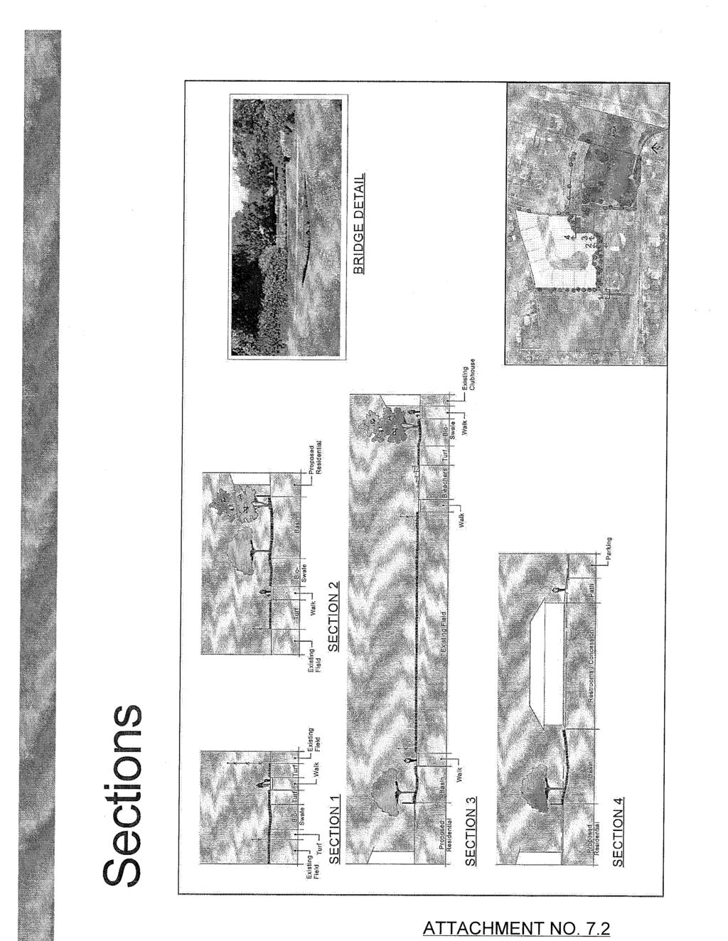
13 Residential Design The existing homes in the vicinity are predominantly two-story homes north, south and west of the project site. The proposed project would likely consist of entirely two-story homes and be subject to the base height allowable in the RL zoning district. Furthermore, the homes would be designed in accordance with the City s adopted Urban Design Guidelines, which include provisions to minimize overall building mass and scale by incorporating facade breaks, upper floor setbacks, and roof variations into the design to enable the new homes to blend with the surrounding existing neighborhood to the extent possible. The 15 single-family homes would be required to comply with the Huntington Beach Zoning and Subdivision Ordinance (HBZSO), the Huntington Beach Municipal Code (HBMC) and all applicable codes to ensure that the design of the homes is compatible with the surrounding residences. In addition, proposed homes abutting existing single-family residences on Crailet Drive will be required to maintain 20-foot rear yard setbacks, which would double the 10-foot setback requirement of the base RL zoning district. The extended setbacks provide an adequate buffer for existing residences by providing additional protection from any associated light, noise, or privacy impacts. Grade Differential Although the project site currently has a grade differential greater than three feet across the site, the project s residential building pad elevations would be compatible with the neighborhood as the differential only ranges from 12 to 20 inches above the abutting residences north of the project site. This condition is not uncommon within existing and new developments and potential concerns related to the grade differential would be minimized by increased minimum rear yard setbacks for proposed lots that abut existing homes on Crailet Drive. Building heights would be in conformance with the RL zoning district. In addition, it should be noted that the project site is currently developed with a former school building/hbcsd administrative headquarters and does not represent an undeveloped condition. LeBard Park/Sports Fields Improvements The project is proposing improvements to LeBard Park and the existing sports fields area that would be acquired by the City. The improvements include construction of a new concession/restroom/storage building, ADA-compliant walkways, improvements to the parking lot and increased park areas designed for passive use and functioning as a water quality/detention basin. Parking Lot Improvements/Variance The project is proposing to reconfigure and expand the existing LeBard Park parking lot to provide additional spaces for the Park. These spaces would generally only be needed during the peak use of the park, which would occur during the regular little league season from March to May. While little league activities occur during other times of the year, the peak season is generally recognized to occur during those months with peak times occurring on the weekend afternoons and weekday late afternoons/early evenings. The proposed spaces are not required by the HBZSO, but would provide additional spaces for vehicles that would otherwise park in the surrounding neighborhoods. Other options for parking within the park have been considered by the HBCSD but were not ultimately included in the proposed project as there was not a desire to add parking in other areas of the park that could impact the sports fields or passive recreational areas. The City could also consider seeking approval from Southern California Edison for use of the adjacent 2-acre right-of-way for overflow parking on an as-needed basis. However, this area cannot be considered as a permanent or long-term parking alternative. PC Staff Report 6/9/ sr18 (LeBard)
14 The proposed parking lot improvements would provide a perimeter parking lot landscape planter along Warwick Drive. The landscape planter varies in width from the required 10 feet to four feet. As such, the applicant is seeking a variance to allow a four-foot-wide landscape planter along a portion of the parking lot adjacent to Warwick Drive in lieu of the required 10 feet. The current parking lot at LeBard Park does not have perimeter landscaping and the existing sidewalk along the street is not separated by a landscaped parkway. The proposed project would incorporate both of these features and bring the park into greater compliance with existing codes. Similar to many of the City s existing parks that were built with the original surrounding subdivision, the park is surrounded by single-family residential uses with limited parking designed to code requirements that are no longer in effect. Due to existing improvements within LeBard Park, the area for improvements to the parking lot and public right-of-way, which would provide landscaped parkways, new sidewalks and ADA-compliant walkways is limited. The site is constrained by the location of existing amenities within the park (tennis courts and passive recreation area) that are not proposed to be relocated or reconfigured within the park. The variance is necessary to achieve upgrades within the park such as ADA-compliant walkways and improvements such as new sidewalks and street adjacent landscaped parkways that are consistent with the surrounding neighborhood. The reduction in the perimeter parking lot landscaping would allow for a landscaped parkway adjacent to the street to buffer the sidewalk where none currently exists, thereby improving pedestrian safety. In addition, strict compliance with the 10-foot perimeter landscaping requirement could result in impacts on the existing park amenities and disruption of those amenities to the public. Based on this analysis, staff recommends approval of the proposed variance. Water Quality/Detention Basin Improvements The project will have one storm water detention basin for flood control purposes located south of Lots 10 and 11 of the new subdivision and identified as Lot A on the tentative tract map. The entire new subdivision will drain to this basin. This basin is also designed with low impact design (LID) parameters to provide water quality treatment as a Best Management Practice (BMP) for the site. This area is the only water quality treatment included for the proposed subdivision as the project site s poor soil quality would not allow for infiltration into the existing ground. Due to the lack of existing underground storm drain facilities, filtration treatment facilities are not feasible and the site must surface drain to the surrounding streets. Although this area serves to accommodate the proposed subdivision s water quality and drainage requirements, it will be designed to function as a new passive park area with amenities such as shade trees, picnic tables and benches. This area would also provide a buffer for the residential lots (Lots 10 and 11) that abut the sports fields. The incorporation of bioretention basins, detention basins, and vegetated swales (referred to as Best Management Practices [BMPs]) is a common engineering practice for managing and mitigating storm runoff in a safe, effective manner. There are examples within the City where parks or areas within parks have been used for similar dual purposes, notably Wardlow Park and Bauer Park. The BMPs are designed to attenuate storm runoff flows and discharge the runoff over a longer period of time in order to reduce peak water flows draining off site. In addition, the BMPs are designed to serve as water quality measures by filtering out pollutants from the runoff. These pollutants are removed from the site through routine maintenance procedures and do not create a risk to persons or biological resources as they are contained within the BMP. In addition, the project s WQMP requires maintenance of this area to ensure its useful PC Staff Report 6/9/ sr18 (LeBard)
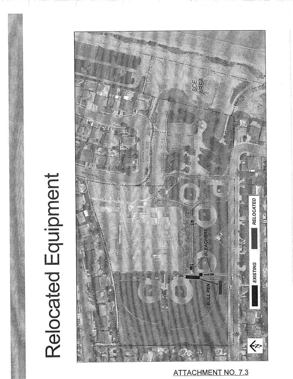
15 function. It should be noted that ownership and maintenance of this area of the park would be the responsibility of the new subdivision HOA. Sports Fields Improvements The project results in minor improvements within the area of the six sports fields that would be acquired by the City. These improvements include relocation of bleachers and a bullpen to accommodate the project s proposed drainage features and ADA-compliant walkways. The conditions of approval also recommend a netting/fencing plan, which could result in potential backstop modifications and new protective netting. The HBCSD has intentionally proposed minimal changes to the sports fields to avoid disruption of activities and use of the fields. This is also consistent with the previous City Council s discussions and the approved MOU that all six fields would remain and be acquired by the City. SUMMARY: Staff recommends approval of the project for the following reasons: - Consistent with surrounding zoning and land use designations; - Results in the preservation and acquisition of approximately 6.5 acres of parkland; - Provides for the creation of new housing units in the City, including affordable housing; - Provides compatible zoning and General Plan land use designations; - Proposed lots are compatible with other residential uses surrounding the project site; - Meets the requirements of the Subdivision Map Act and has been reviewed by the Subdivision Committee for compliance; - Consistent with City Council direction and the approved MOU between the City and the HBCSD; and - Developed as a PUD and provide mutual public benefits, including a new restroom, storage and concession building, parking lot improvements, upgraded ADA-compliant access paths, and increased passive park area. ATTACHMENTS: 1. Suggested Findings and Conditions of Approval for Negative Declaration No , Zoning Map Amendment No , Tentative Tract Map No , Conditional Use Permit No , Variance No not attached refer to RCA Attachment No Draft City Council Resolution No. for General Plan Amendment No not attached refer to RCA Attachment No Draft City Council Ordinance No. for Zoning Map Amendment No not attached refer to RCA Attachment No Existing and Proposed General Plan Land Use Designation Map not attached refer to RCA Attachment No Existing and Proposed Zoning Map not attached refer to RCA Attachment No Tentative Tract Map No and project site plans dated and received January 21, 2015 not attached refer to RCA Attachment No Park improvement plans, November 19, Revised Narrative dated January 23, Project Code Requirements (for informational purposes only) 10. Draft Mitigated Negative Declaration No not attached; refer to website: not attached refer to RCA Attachment No. 7 PC Staff Report 6/9/ sr18 (LeBard)
16 11. Response to Comments and Changes to Draft MND No not attached refer to RCA Attachment No Public comments (excluding comment letters on the draft MND) received as of June 2, City Council approved MOU, May 5, Minutes of the Community Services Commission, November 19, 2014 SH:JJ:jv PC Staff Report 6/9/ sr18 (LeBard)

17
18
19
20
21
22
23
24
25
26
27
28
29
30
31
32
33
34
35
36
37
38
39
40
41
42
43
44
45
46
47
48
49
50
51
52
53
54
55
56
57
58
59
60
61
62
63
64
65
66
67
68
69
70
71
72
73
Appendix J - Planned Unit Development (PUD)
") Appendix J - Planned Unit Development (PUD) Intent and Purpose The purpose of the PUD is: 1. To provide development that is consistent with the Comprehensive Land Use Plan and promote the goals and objectives
Appendix J - Planned Unit Development (PUD) Intent and Purpose The purpose of the PUD is: 1. To provide development that is consistent with the Comprehensive Land Use Plan and promote the goals and objectives
City of Huntington Beach Community Development Department STAFF REPORT
 City of Huntington Beach Community Development Department STAFF REPORT TO: Planning Commission FROM: Scott Hess, AICP, Director of Community Development BY: Jessica Bui, Assistant Planner DATE: June 28,
REPORT TO PLANNING AND DESIGN COMMISSION City of Sacramento
 REPORT TO PLANNING AND DESIGN COMMISSION City of Sacramento 915 I Street, Sacramento, CA 95814-2671 www.cityofsacramento.org 9 PUBLIC HEARING December 10, 2015 To: Members of the Planning and Design Commission
COUNTY OF SAN MATEO PLANNING AND BUILDING DEPARTMENT
 COUNTY OF SAN MATEO PLANNING AND BUILDING DEPARTMENT DATE: October 20, 2016 TO: FROM: Zoning Hearing Officer Planning Staff SUBJECT: Consideration of a Non-Conforming Use Permit, pursuant to Sections 6135
ARTICLE 15 - PLANNED UNIT DEVELOPMENT
 Section 15.1 - Intent. ARTICLE 15 - PLANNED UNIT DEVELOPMENT A PUD, or Planned Unit Development, is not a District per se, but rather a set of standards that may be applied to a development type. The Planned
CITY COUNCIL STAFF REPORT
 CITY COUNCIL STAFF REPORT TO: Honorable Mayor and City Council DATE: May 7, 2018 FROM: PREPARED BY: SUBJECT: Matthew Bronson, City Manager A. Rafael Castillo, AICP, Senior Planner Cassandra Mesa, Building
PLANNED UNIT DEVELOPMENT (PUD)
") SECTION 38.01. ARTICLE 38 PLANNED UNIT DEVELOPMENT (PUD) Purpose The purpose of this Article is to implement the provisions of the Michigan Zoning Enabling Act, Public Act 110 of 2006, as amended, authorizing
SECTION 38.01. ARTICLE 38 PLANNED UNIT DEVELOPMENT (PUD) Purpose The purpose of this Article is to implement the provisions of the Michigan Zoning Enabling Act, Public Act 110 of 2006, as amended, authorizing
Planning Commission Report
 Beverly Hills Planning Division 455 N. Rexford Drive Beverly Hills, CA 90210 TEL. (310) 458-1140 FAX. (310) 858-5966 Planning Commission Report Meeting Date: September 27, 2012 Subject: 366 North Rodeo
Cover Letter with Narrative Statement
 Cover Letter with Narrative Statement March 31, 2017 rev July 27, 2017 RE: Rushton Pointe Residential Planned Unit Development Application for Public Hearing for RPUD Rezone PL2015 000 0306 Mr. Eric Johnson,
UPPER MOUNT BETHEL TOWNSHIP NORTHAMPTON COUNTY, PENNSYLVANIA
 UPPER MOUNT BETHEL TOWNSHIP NORTHAMPTON COUNTY, PENNSYLVANIA JOINDER DEED / LOT CONSOLIDATION TOWNSHIP REVIEW PROCESS When accepting proposed Joinder Deeds / Lot Consolidations, review the Joinder Deed
PLANNING COMMISSION MAY 3, 2018 PUBLIC HEARING
 PLANNING COMMISSION MAY 3, 2018 PUBLIC HEARING SUBJECT: REQUEST TO DEMOLISH TWO SINGLE-FAMILY DWELLINGS ON TWO ADJOINING LOTS AND CONSTRUCT TEN RESIDENTIAL CONDOMINIUM UNITS AT 947 GENESEE AVENUE AND 944
SUBJECT: Application for Planned Unit Development and Rezoning 1725 Winnetka Road
 TO: FROM: CHAIRMAN BILL VASELOPULOS AND MEMBERS OF THE PLAN & ZONING COMMISSION STEVE GUTIERREZ DIRECTOR OF COMMUNITY DEVELOPMENT MEETING DATE: September 5, 2017 SUBJECT: Application for Planned Unit Development
Planning Commission Report
 cjly City of Beverly Hills Planning Division 455 N. Rexford Drive Beverly Hills, CA 90210 TEL. (310) 285-1141 FAX. (370) 858-5966 Planning Commission Report Meeting Date: April 28, 2016 Subject: Project
PIN , Part 1, Plan SR-713 in Lot 2, Concession 5, Township of McKim (1096 Dublin Street, Sudbury)
") STAFF REPORT Applicant: Dalron Construction Limited Location: PIN 02124-0103, Part 1, Plan SR-713 in Lot 2, Concession 5, Township of McKim (1096 Dublin Street, Sudbury) Official Plan and Zoning By-law:
STAFF REPORT Applicant: Dalron Construction Limited Location: PIN 02124-0103, Part 1, Plan SR-713 in Lot 2, Concession 5, Township of McKim (1096 Dublin Street, Sudbury) Official Plan and Zoning By-law:
Planning Department Oconee County, Georgia
 Planning Department Oconee County, Georgia STAFF REPORT REZONE CASE #: 6985 DATE: October 31, 2016 STAFF REPORT BY: Andrew C. Stern, Planner APPLICANT NAME: Williams & Associates, Land Planners PC PROPERTY
CITY OF SIGNAL HILL SUBJECT: PUBLIC HEARING THE COURTYARD RESIDENTIAL DEVELOPMENT OF 10 CONDOMINIUMS AND A NEW SPECIFIC PLAN
 CITY OF SIGNAL HILL 2175 Cherry Avenue Signal Hill, CA 90755-3799 AGENDA ITEM TO: FROM: HONORABLE CHAIR AND MEMBERS OF THE PLANNING COMMISSION SELENA ALANIS ASSOCIATE PLANNER SUBJECT: PUBLIC HEARING THE
Guide to Preliminary Plans
 Guide to Preliminary Plans Introduction The Douglas County is committed to providing open, transparent application processes to the public. This Guide is provided to assist anyone interested in the procedures
TOWN OF WHITBY REPORT RECOMMENDATION REPORT
 TOWN OF WHITBY REPORT RECOMMENDATION REPORT REPORT TO: Planning and Development Committee REPORT NO: PL 4-08 DATE OF MEETING: January 21, 2008 FILE NO(S): MI-01-07 (SW- 2002-03) PREPARED BY: Planning Department
Staff Report PLANNED DEVELOPMENT. Salt Lake City Planning Commission. From: Lauren Parisi, Associate Planner; Date: December 14, 2016
 Staff Report PLANNING DIVISION COMMUNITY & NEIGHBORHOODS To: Salt Lake City Planning Commission From: Lauren Parisi, Associate Planner; 801-535-7932 Date: December 14, 2016 Re: 1611 South 1600 East PLANNED
PLANNED UNIT DEVELOPMENT & SUBDIVISION STAFF REPORT Date: April 18, 2019
 PLANNED UNIT DEVELOPMENT & SUBDIVISION STAFF REPORT Date: April 18, 2019 DEVELOPMENT NAME SUBDIVISION NAME Springhill Village Subdivision Springhill Village Subdivision LOCATION 4350, 4354, 4356, 4358,
THE AREA PLAN COMMISSION OF ST. JOSEPH COUNTY, IN AGENDA
 THE AREA PLAN COMMISSION OF ST. JOSEPH COUNTY, IN AGENDA Tuesday, January 17, 2017 Fourth-Floor Council Chambers 3:30 p.m. County-City Building, South Bend, IN EXECUTIVE SESSION: A. Election of Officers
5.03 Type III (Quasi-Judicial) Decisions
 Decisions") 5.03 Type III (Quasi-Judicial) Decisions 5.03 General Requirements A. The purpose of this Section is to identify what types of actions are considered Type III decisions. Type III decisions involve significant
5.03 Type III (Quasi-Judicial) Decisions 5.03 General Requirements A. The purpose of this Section is to identify what types of actions are considered Type III decisions. Type III decisions involve significant
ARTICLE VII. NONCONFORMITIES. Section 700. Purpose.
 ARTICLE VII. NONCONFORMITIES. Section 700. Purpose. The purpose of this chapter is to regulate and limit the development and continued existence of legal uses, structures, lots, and signs established either
Guide to Replats. Step 1. Step 2. Step 3. Step 4. Step 5. Step 6. Step 7. Step 8. Step 9. Step 10
 Guide to Replats Introduction Douglas County is committed to providing open, transparent application processes to the public. This Guide is provided to assist anyone interested in the procedures and expectations
TOWN OF ORO VALLEY PLANNING & ZONING COMMISSION MEETING DATE: December 6, 2011
 PLANNING & ZONING COMMISSION MEETING DATE: December 6, 2011 TO: FROM: SUBJECT: PLANNING & ZONING COMMISSION Matt Michels, Senior Planner mmichels@orovalleyaz.gov; tel. 229-4822 Public Hearing: Rancho de
The City of Carlsbad Planning Division A REPORT TO THE PLANNING COMMISSION. Item No. P.C. AGENDA OF: March 16, 2011 Project Planner: Shannon Werneke
 The City of Carlsbad Planning Division A REPORT TO THE PLANNING COMMISSION Item No. 2 Application complete date: January 24, 2011 P.C. AGENDA OF: March 16, 2011 Project Planner: Shannon Werneke Project
Sterling Meadow Subdivision
 Sterling Meadow Subdivision Proposal: A pre-application conference was held on November 7, 2017, with the applicant and City staff to discuss the development. The applicant took staff s recommendations
The following regulations shall apply in the R-E District:
 "R-E" RESIDENTIAL ESTATE DISTRICT (8/06) The following regulations shall apply in the R-E District: 1. Uses Permitted: The following uses are permitted. A Zoning Certificate may be required as provided
THE REDEVELOPMENT PLAN
 PAGE 37 THE REDEVELOPMENT PLAN FUTURE LAND USE The Silver Terrace Redevelopment Area is currently designated as Redevelopment Area #4 on the City of Delray Beach Future Land Use Map (FLUM). This designation
Planning Rationale in Support of an Application for Plan of Subdivision and Zoning By-Law Amendment
 Planning Rationale in Support of an Application for Plan of Subdivision and Zoning By-Law Amendment The Kilmorie Development 21 Withrow Avenue City of Ottawa Prepared by: Holzman Consultants Inc. Land
ARTICLE FIVE FINAL DRAFT
 ARTICLE FIVE 021218 FINAL DRAFT Sec. 503.6 Open Space Preservation Option Open Space Preservation Option Open Space Preservation developments may be approved in the AR, R-1, R-2 and R-3 zoning districts,
Plan nt Plan Filing and
 PARISH OF ASCENSION OFFICE OF PLANNING AND DEVELOPMENT PLANNING DEPARTMENT APPENDIX VI PLANNED UNIT DEVELOPMENT (PUD) CODE Contents: 17-601. General Purpose: Procedures... 3 17-602. General Character:...
ZONING AMENDMENT & SUBDIVISION STAFF REPORT Date: November 3, 2016
 ZONING AMENDMENT & SUBDIVISION STAFF REPORT Date: November 3, 2016 APPLICANT NAME SUBDIVISION NAME David Shumer 5955 Airport Subdivision CITY COUNCIL DISTRICT District 6 5955 Airport Boulevard, 754 Linlen
ARTICLE 24 SITE PLAN REVIEW
 ARTICLE 24 SITE PLAN REVIEW 24.1 PURPOSE: The intent of these Ordinance provisions is to provide for consultation and cooperation between the land developer and the Township Planning Commission in order
Charter Township of Plymouth Zoning Ordinance No. 99 Page 208 Article 21: Residential Unit Developments Amendments: ARTICLE XXI
 Charter Township of Plymouth Zoning Ordinance No. 99 Page 208 ARTICLE XXI RESIDENTIAL UNIT DEVELOPMENTS PURPOSE The purpose of the Residential Unit Development (RUD) is to permit two (2) optional methods
DEVELOPMENT STANDARDS
 Chapter 5 DEVELOPMENT STANDARDS 501 Residential Development Standards 502 Neighborhood Commercial Standards 503 Mixed Use Standards 504 Industrial Development Standards 505 Public Use Standards 506 Open
ARTICLE 8C SITE CONDOMINIUM DEVELOPMENT ORDINANCE
 ARTICLE 8C SITE CONDOMINIUM DEVELOPMENT ORDINANCE SECTION 8C.01 PURPOSE It is the purpose of this Ordinance to insure that plans for development within Oceola Township proposed under the provisions of
Staff Report: Date: Applicant: Property Identification: Acreage of Request: Current Zoning of Requested Area: Requested Action: Attached:
 Staff Report: Completed by Jeff Palmer Director of Planning & Zoning Date: November 7, 2018, Updated November 20, 2018 Applicant: Greg Smith, Oberer Land Developer agent for Ronald Montgomery ET AL Property
P. H. Robinson Consulting Urban Planning, Consulting and Project Management
 PLANNING RATIONALE REPORT FOR SITE PLAN AND DRAFT PLAN OF CONDOMINIUM APPLICATIONS 73-75 HARVEY STREET CITY OF OTTAWA PREPARED BY: P H ROBINSON CONSULTING AUGUST 2012 1 This report has been prepared on
CITY OF KAMLOOPS BYLAW NO A BYLAW TO AMEND THE ZONING BYLAW OF THE CITY OF KAMLOOPS
 67 68 CITY OF KAMLOOPS BYLAW NO. 5-1-2796 A BYLAW TO AMEND THE ZONING BYLAW OF THE CITY OF KAMLOOPS The Municipal Council of the City of Kamloops, in open meeting assembled, enacts as follows: 1. This
PLANNING COMMISSION STAFF REPORT. Merrimac PLNSUB Planned Development 38 West Merrimac November 9, Request. Staff Recommendation
 PLANNING COMMISSION STAFF REPORT Merrimac PLNSUB2011-00374 Planned Development 38 West Merrimac November 9, 2011 Planning and Zoning Division Department of Community and Economic Development Applicant:
Appendix1,Page1. Urban Design Guidelines. Back to Back and Stacked Townhouses. DRAFT September 2017
 Appendix1,Page1 Urban Design Guidelines DRAFT September 2017 Back to Back and Stacked Townhouses Appendix1,Page2 Table of Contents 1 Introduction 1 1.1 Purpose 1 1.2 Urban Design Objectives 1 1.3 Building
Chapter 22 PLANNED UNIT DEVELOPMENT.
 Chapter 22 PLANNED UNIT DEVELOPMENT. Sec. 22.1 INTENT. The use of land and the construction and use of buildings and other structures as Planned Unit Developments in Georgetown Township may be established
Town of Cary, North Carolina Rezoning Staff Report 14-REZ-31 Cary Park PDD Amendment (Waterford II) Town Council Meeting January 15, 2015
 Town Council Meeting January 15, 2015") Town of Cary, North Carolina Rezoning Staff Report 14-REZ-31 Cary Park PDD Amendment (Waterford II) Town Council Meeting January 15, 2015 REQUEST To amend the Town of Cary Official Zoning Map by amending
Town of Cary, North Carolina Rezoning Staff Report 14-REZ-31 Cary Park PDD Amendment (Waterford II) Town Council Meeting January 15, 2015 REQUEST To amend the Town of Cary Official Zoning Map by amending
CHAPTER SUBDIVISION MAPS
 CHAPTER 19.66 SUBDIVISION MAPS SUBDIVISION MAPS 19.66 Section Page 19.66.010 Purpose... IV-56 19.66.020 Application... IV-57 19.66.030 Exclusions... IV-57 19.66.040 Effect of Annexation... IV-57 19.66.050
CITY OF RIO VISTA PLANNING COMMISSION STAFF REPORT
 MEETING DATE: January10, 2018 CITY OF RIO VISTA PLANNING COMMISSION STAFF REPORT AGENDA ITEM #4.2 PREPARED BY: Lamont Thompson, Planning Manager SUBJECT: Vesting Tentative Tract No. 2017-001: To consider
LEMOORE PLANNING COMMISSION Regular Meeting AGENDA Lemoore Council Chamber 429 C Street. May 14, :00 p.m.
 LEMOORE PLANNING COMMISSION Regular Meeting AGENDA Lemoore Council Chamber 429 C Street May 14, 2018 7:00 p.m. 1. Pledge of Allegiance 2. Call to Order and Roll Call 3. Public Comment This time is reserved
FINAL DRAFT 12/1/16, Rev. to 7/18/17
 FINAL DRAFT 12/1/16, Rev. to 7/18/17 (As Adopted 8/8/17 Effective 9/1/17) SHELTON PLANNING AND ZONING COMMISSION Proposed Amendments to Zoning Regulations I. Amend Section 23 PERMITTED USES by inserting
O-I (Office-Institutional) and AG-1(Agricultural)
 and AG-1(Agricultural)") PROPERTY INFORMATION ADDRESS 3503 and 3505 Bethany Bend DISTRICT, LAND LOTS 2/1 973 and 974 OVERLAY DISTRICT State Route 9 PETITION NUMBERS EXISTING ZONING O-I (Office-Institutional) and AG-1(Agricultural)
PROPERTY INFORMATION ADDRESS 3503 and 3505 Bethany Bend DISTRICT, LAND LOTS 2/1 973 and 974 OVERLAY DISTRICT State Route 9 PETITION NUMBERS EXISTING ZONING O-I (Office-Institutional) and AG-1(Agricultural)
Guide to Minor Developments
 Guide to Minor Developments Introduction The Douglas County (DCD) is committed to providing open, transparent application processes to the public. This Guide is provided to assist anyone interested in
610 LAND DIVISIONS AND PROPERTY LINE ADJUSTMENTS OUTSIDE A UGB
 ARTICLE VI: LAND DIVISIONS AND PROPERTY LINE ADJUSTMENTS VI-21 610 LAND DIVISIONS AND PROPERTY LINE ADJUSTMENTS OUTSIDE A UGB 610-1 Property Line Adjustments (Property Line Relocation) A property line
Community Development Department 333 Broadalbin Street SW, P.O. Box 490 Albany, OR 97321
 SUMMARY Community Development Department 333 Broadalbin Street SW, P.O. Box 490 Albany, OR 97321 STAFF REPORT Application for Tentative Partition Plat Review Planning File PA-06-17 Phone: 541-917-7550
AGENDA STATEMENT NO BUSINESS OF THE PLANNING COMMISSION City of Victoria, Minnesota STAFF REPORT. Casco Ventures (Developer)
") AGENDA STATEMENT NO. 17-1 BUSINESS OF THE PLANNING COMMISSION City of Victoria, Minnesota STAFF REPORT TO: Planning Commission PREPARED BY: Erin Smith, Senior Planner RE: Waterford Landing Project Rezoning
AGENDA STATEMENT NO. 17-1 BUSINESS OF THE PLANNING COMMISSION City of Victoria, Minnesota STAFF REPORT TO: Planning Commission PREPARED BY: Erin Smith, Senior Planner RE: Waterford Landing Project Rezoning
RP-2, RP-3, RP-4, AND RP-5 PLANNED RESIDENTIAL DISTRICTS
 6.10 - RP-2, RP-3, RP-4, AND RP-5 PLANNED RESIDENTIAL DISTRICTS 6.10.1 GENERAL DESCRIPTION: 6.10.1.1 The regulations established in this Section are intended to provide optional methods of land development
PLANNED UNIT DEVELOPMENTS (Ordinance No.: 3036, 12/3/07; Repealed & Replaced by Ordinance No.: 4166, 10/15/12)
") 159.62 PLANNED UNIT DEVELOPMENTS (Ordinance No.: 3036, 12/3/07; Repealed & Replaced by Ordinance No.: 4166, 10/15/12) A. PURPOSE 1. General. The Planned Unit Development (PUD) approach provides the flexibility
159.62 PLANNED UNIT DEVELOPMENTS (Ordinance No.: 3036, 12/3/07; Repealed & Replaced by Ordinance No.: 4166, 10/15/12) A. PURPOSE 1. General. The Planned Unit Development (PUD) approach provides the flexibility
Town of Cary, North Carolina Rezoning Staff Report 12-REZ-27 Morris Branch Town Council Public Hearing January 24, 2013
 Town of Cary, North Carolina Rezoning Staff Report 12-REZ-27 Morris Branch Town Council Public Hearing January 24, 2013 REQUEST To amend the Town of Cary Official Zoning Map to rezone approximately 9.0
RESOLUTION PC NOW THEREFORE, the Planning Commission of the City of Duarte resolves as follows:
 RESOLUTION PC 18-09 A RESOLUTION OF THE PLANNING COMMISSION OF THE CITY OF DUARTE APPROVING CONDITIONAL USE PERMIT 14-02, FOR THE USE AND OPERATION OF A WIRELESS COMMUNICATION FACILITY FOR VERIZON WIRELESS,
4.2 LAND USE INTRODUCTION
 4.2 LAND USE INTRODUCTION This section of the EIR addresses potential impacts from the Fresno County General Plan Update on land use in two general areas: land use compatibility and plan consistency. Under
3.1. OBJECTIVES FOR RESIDENTIAL LAND USE DESIGNATIONS GENERAL OBJECTIVES FOR ALL RESIDENTIAL DESIGNATIONS
 3. RESIDENTIAL LAND USE DESIGNATIONS INTRODUCTION The Residential land use designations provide for housing and other land uses that are integral to, and supportive of, a residential environment. Housing
PALM BEACH COUNTY PLANNING, ZONING AND BUILDING DEPARTMENT ZONING DIVISION
 PALM BEACH COUNTY PLANNING, ZONING AND BUILDING DEPARTMENT ZONING DIVISION Application No.: CA-2012-00688 Control No.: 2011-00552 Applicant: Garry Bernardo Owners: Garry Bernardo Agent: Frogner Consulting,
RIVER VALE MASTER PLAN PZ CITY COUNCIL PUBLIC HEARING JULY 19, 2017 CITY OF BEND
 RIVER VALE MASTER PLAN PZ-16-0954 CITY COUNCIL PUBLIC HEARING JULY 19, 2017 RIVER VALE MASTER PLAN Master Plan process Required for developments over 20 acres Application submitted under old Master Plan
GROSVENOR-STRATHMORE METRO STATION MANDATORY REFERRAL APPLICATION NORTH BETHESDA, MD
 GROSVENOR-STRATHMORE METRO STATION MANDATORY REFERRAL APPLICATION NORTH BETHESDA, MD Submission by: Fivesquares JDA at Grosvenor Metro, LLC On behalf of Washington Metropolitan Area Transit Authority 1
Residential Project Convenience Facilities
 Standards for Specific Land Uses 35.42.220 E. Findings. The review authority shall approve a Land Use Permit in compliance with Subsection 35.82.110.E (Findings required for approval) or a Conditional
CHAPTER34 PRUD - PLANNED RESIDENTIAL UNIT DEVELOPMENT
 CHAPTER34 PRUD - PLANNED RESIDENTIAL UNIT DEVELOPMENT 17-34-1 17-34-2 17-34-3 17-34-4 17-34-5 17-34-6 17-34-7 17-34-8 17-34-9 Purpose Planned Residential Unit Development Defined Planned Residential Unit
ORANGE BLOSSOM GARDENS PLANNED UNIT DEVELOPMENT PREPARED BY: COASTAL ENGINEERING CONSULTANTS, INC.
 ORANGE BLOSSOM GARDENS A PLANNED UNIT DEVELOPMENT PREPARED BY: COASTAL ENGINEERING CONSULTANTS, INC. REVISED OCTOBER 19, 1992 BY THE COLLIER COUNTY LONG RANGE PLANNING DEPARTMENT REVISED DECEMBER, 2008
WALNUT CREEK DESIGN REVIEW COMMISSION STAFF REPORT. AGENDA: July 6, 2016 ITEM 4b.
 WALNUT CREEK DESIGN REVIEW COMMISSION STAFF REPORT Attachment 3 AGENDA: July 6, 2016 ITEM 4b. ORIGINATED BY: COMMUNITY AND ECONOMIC DEVELOPMENT DEPARTMENT PLANNING PROJECT NAME APPLICATION TYPE APPLICATION
Plan Dutch Village Road
 Plan Dutch Village Road Objective: The lands around Dutch Village Road are a minor commercial area that services the larger Fairview community. Maintaining the vibrancy of the area by planning for redevelopment
LAND USE AND ZONING OVERVIEW
 OVERVIEW OF PLANNING POLICIES LAND USE AND ZONING OVERVIEW The Minneapolis Plan for Sustainable Growth and Other Adopted Plans Community Planning and Economic Development Development Services Division
City of San Juan Capistrano Agenda Report
 City of San Juan Capistrano Agenda Report TO: Zoning Administrator FROM: Reviewed by: Sergio Klotz, AICP, Assistant Development Services DirctJ. o ~ Prepared by: Laura Stokes, Housing Coordinator I Assistant
TOTTENHAM SECONDARY PLAN
 TOTTENHAM SECONDARY PLAN AMENDMENT NO. 11 TO THE OFFICIAL PLAN OF THE TOWN OF NEW TECUMSETH The following text and schedules to the Official Plan of the Town of New Tecumseth constitute Amendment No. 11
APPLICANT NAME SUBDIVISION NAME DEVELOPMENT NAME LOCATION. CITY COUNCIL DISTRICT Council District 4 PRESENT ZONING PROPOSED ZONING
 SUBDIVISION, PLANNED UNIT DEVELOPMENT, PLANNING APPROVAL, ZONING AMENDMENT, & SIDEWALK WAIVER REQUEST STAFF REPORT Date: February 17, 2010 APPLICANT NAME SUBDIVISION NAME DEVELOPMENT NAME LOCATION David
PROPOSED AMENDMENTS TO THE DERBY ZONING REGULATIONS AUGUST 12, 2008
 ARTICLE II Definitions and word usage 195-7. Definitions and word usage. Modify the following: HOUSING FOR THE ELDERLY OLDER PERSONS Housing in accordance with and as defined in the United States Fair
Guide to Combined Preliminary and Final Plats
 Guide to Combined Preliminary and Final Plats Introduction The Douglas County is committed to providing open, transparent application processes to the public. This Guide is provided to assist anyone interested
County of Sonoma Agenda Item Summary Report
 County of Sonoma Agenda Item Summary Report Agenda Item Number: 36 (This Section for use by Clerk of the Board Only.) Clerk of the Board 575 Administration Drive Santa Rosa, CA 95403 To: Board of Supervisors
DEVELOPMENT DEPARTMENT STAFF REPORT DRESDEN HEIGHTS PHASE II DCI
 DEVELOPMENT DEPARTMENT Meeting Date: January 10, 2019 Item #: PZ2019-393 Project Name: Applicant and Owner: Proposed Development: Requests: STAFF REPORT DRESDEN HEIGHTS PHASE II DCI Dresden Heights Phase
H4. Residential Mixed Housing Suburban Zone
 H4. Residential Mixed Housing Suburban Zone H4.1. Zone description The Residential Mixed Housing Suburban Zone is the most widespread residential zone covering many established suburbs and some greenfields
Letter of Intent May 2017 (Revised November 2017)
") THE BEACH AT WOODMOOR LETTER OF INTENT MAY 2017 (REVISED NOVEMBER 2017) OWNER/APPLICANT: CONSULTANT: Lake Woodmoor Holdings LLC N.E.S. Inc. 1755 Telstar Drive, Suite 211 619 North Cascade Avenue Colorado
THE BEACH AT WOODMOOR LETTER OF INTENT MAY 2017 (REVISED NOVEMBER 2017) OWNER/APPLICANT: CONSULTANT: Lake Woodmoor Holdings LLC N.E.S. Inc. 1755 Telstar Drive, Suite 211 619 North Cascade Avenue Colorado
ARTICLE I ZONE BASED REGULATIONS
 ARTICLE I ZONE BASED REGULATIONS RZC 21.08 RESIDENTIAL REGULATIONS 21.08.290 Cottage Housing Developments A. Purpose. The purpose of the cottage housing requirements is to: 1. Provide a housing type that
RESOLUTION NO. FILE NO. PT14-047
 RESOLUTION NO. A RESOLUTION OF THE COUNCIL OF THE CITY OF SAN JOSE APPROVING A VESTING TENTATIVE MAP TO SUBDIVIDE ONE (1) LOT INTO NINE (9) LOTS FOR RESIDENTIAL USES, AND ONE (1) LOT FOR COMMON USES ON
PLANNING COMMISSION REPORT REGULAR AGENDA
 PP-4-4-11 Item No. 9-1 PLANNING COMMISSION REPORT REGULAR AGENDA PC Staff Report 06/22/11 ITEM NO 9: PRELIMINARY PLAT; KASOLD WATER TOWER ADDITION; SE OF TAM O SHANTER & KASOLD DR (MKM) PP-4-4-11: Consider
Operating Standards Attachment to Development Application
 Planning & Development Services 2255 W Berry Ave. Littleton, CO 80120 Phone: 303-795-3748 Mon-Fri: 8am-5pm www.littletongov.org Operating Standards Attachment to Development Application 1 PLANNED DEVELOPMENT
Supplemental Application Form Request for a Waiver of Development Standards via Density Bonus
 County of Sacramento Office of Planning and Environmental Review (PER) 827 7 th Street, Room 225 Sacramento, CA 95814 (916) 874-6141 Supplemental Application Form Request for a Waiver of Development Standards
PLANNED UNIT DEVELOPMENT & SUBDIVISION STAFF REPORT Date: July 20, 2017
 PLANNED UNIT DEVELOPMENT & SUBDIVISION STAFF REPORT Date: July 20, 2017 DEVELOPMENT NAME SUBDIVISION NAME LOCATION Rangeline Crossing III Subdivision Rangeline Crossing III Subdivision 5289 Halls Mill
Cobb County Community Development Agency Zoning Division 1150 Powder Springs St. Marietta, Georgia 30064
 Cobb County Community Development Agency Zoning Division 1150 Powder Springs St. Marietta, Georgia 30064 Case # Z-63 Public Hearing Dates: PC: 11-06-18 BOC: 11-20-18 SITE BACKGROUND Applicant: Loyd Development
CHAPTER 10 Planned Unit Development Zoning Districts
 CHAPTER 10 Planned Unit Development Zoning Districts Section 10.1 Intent and Purpose The Planned Unit Development (PUD) districts are intended to offer design flexibility for projects that further the
SUBDIVISION, PLANNED UNIT DEVELOPMENT, ZONING AMENDMENT, & SIDEWALK WAIVER STAFF REPORT Date: July 19, 2018
 SUBDIVISION, PLANNED UNIT DEVELOPMENT, ZONING AMENDMENT, & SIDEWALK WAIVER STAFF REPORT Date: July 19, 2018 NAME SUBDIVISION NAME LOCATION West Mobile Properties, LLC U.S. Machine Subdivision 556, 566,
City and County of Broomfield, Colorado
 City and County of Broomfield, Colorado CITY COUNCIL AGENDA MEMORANDUM To: From: Mayor and City Council George Di Ciero, City and County Manager Teri Malies, Principal Planner Terrance Ware, Planning Director
ZONING AMENDMENT, SUBDIVISION & SIDEWALK WAIVER REQUEST STAFF REPORT Date: November 16, 2006
 ZONING AMENDMENT, SUBDIVISION & SIDEWALK WAIVER REQUEST STAFF REPORT Date: November 16, 2006 NAME SUBDIVISION NAME Terhaar & Cronley Investment Partnership P & E Subdivision LOCATION 4210 and 4218 Halls
PLANNING COMMISSION STAFF REPORT June 18, 2015
 Community Development Department Planning Division 1600 First Street + P.O. Box 660 Napa, CA 94559-0660 (707) 257-9530 PLANNING COMMISSION STAFF REPORT June 18, 2015 AGENDA ITEM 7.B. PL15-0052 PM, GASSER
M E M O. September 14, 2017 Agenda Item #4. Planning Commission. David Goodison, Planning Director
 September 14, 2017 Agenda Item #4 M E M O To: From: Planning Commission David Goodison, Planning Director Re: Preliminary review of an application for a mixed-use development proposed for 870 Broadway
LETTER OF APPLICATION
 Description of Proposed Land Division: LETTER OF APPLICATION The proposed land division would split a 1.94 acres rectangular lot into two lots. The general configuration would have one lot in front of
David J. Gellner, AICP, Principal Planner; (801) ; Zoning Map Amendment
 ; Zoning Map Amendment") Staff Report PLANNING DIVISION DEPARTMENT of COMMUNITY and NEIGHBORHOODS To: From: Salt Lake City Planning Commission David J. Gellner, AICP, Principal Planner; (801) 535-6107; david.gellner@slcgov.com
Staff Report PLANNING DIVISION DEPARTMENT of COMMUNITY and NEIGHBORHOODS To: From: Salt Lake City Planning Commission David J. Gellner, AICP, Principal Planner; (801) 535-6107; david.gellner@slcgov.com
COMMISSION ACTION FORM SUBJECT: ZONING TEXT AMENDMENT FOR LINCOLN WAY CORRIDOR PLAN DOWNTOWN GATEWAY COMMERCIAL ZONING DISTRICT STANDARDS
 ITEM #: 7 DATE: _02-07-18 COMMISSION ACTION FORM SUBJECT: ZONING TEXT AMENDMENT FOR LINCOLN WAY CORRIDOR PLAN DOWNTOWN GATEWAY COMMERCIAL ZONING DISTRICT STANDARDS BACKGROUND: The Downtown Gateway area
M E M O R A N D U M. Meeting Date: October 23, Item No. F-1. Planning and Zoning Commission. Daniel Turner, Planner I
 M E M O R A N D U M Meeting Date: October 23, 2017 Item No. F-1 To: From: Subject: Planning and Zoning Commission Daniel Turner, Planner I PUBLIC HEARING: Consider a recommendation of a of Planned Development
LYON COUNTY COMMUNITY DEVELOPMENT DEPARTMENT
 LYON COUNTY COMMUNITY DEVELOPMENT DEPARTMENT B UILDING D EVELOPMENT E NGINEERING P LANNING 27 S. MAIN S TREET Y ERINGTON, NEVADA 89447 (775) 463-6591 F AX: (775) 463-5305 34 LAKES B OULEVARD D AYTON, NEVADA
H6 Residential Terrace Housing and Apartment Buildings Zone
 H6. Residential Terrace Housing and Apartment Buildings Zone [CIV-2016-404-002333: Franco Belgiorno-Nettis]-Note: The properties affected by this appeal are identified on the Auckland Unitary Plan viewer.
York Neighbourhood Area Structure Plan
 York Neighbourhood Area Structure Plan Office Consolidation March 2006 Prepared by: Planning and Policy Services Branch Planning and Development Department City of Edmonton Bylaw 7064 was adopted by Council
Town of Cary, North Carolina Rezoning Staff Report 14-REZ-24 Indian Wells Road Properties Town Council Meeting November 20, 2014
 Town of Cary, North Carolina Rezoning Staff Report 14-REZ-24 Indian Wells Road Properties Town Council Meeting November 20, 2014 REQUEST To amend the Town of Cary Official Zoning Map by revising a condition
ARTICLE 14 PLANNED UNIT DEVELOPMENT (PUD) DISTRICT
 DISTRICT") ARTICLE 14 PLANNED UNIT DEVELOPMENT (PUD) DISTRICT Section 14.01 Intent. It is the intent of this Article to allow the use of the planned unit development (PUD) process, as authorized by the Michigan Zoning
ARTICLE 14 PLANNED UNIT DEVELOPMENT (PUD) DISTRICT Section 14.01 Intent. It is the intent of this Article to allow the use of the planned unit development (PUD) process, as authorized by the Michigan Zoning
50+54 BELL STREET NORTH
 50+54 BELL STREET NORTH SITE PLAN CONTROL APPLICATION OCTOBER 2014 PREPARED BY: FOTENN Consultants Inc. 223 Mcleod Street Ottawa, ON K2P OZ8 (613) 730-5709 PREPARED FOR: Ottawa Chinese Alliance Church