APPLICATION TO CONSTRUCT A DOCK
|
|
|
- Briana Thompson
- 6 years ago
- Views:
Transcription
1 APPLICATION TO CONSTRUCT A DOCK (In Accordance with Orange County Code Chapter 15, Article IX, Orange County Code) Mail or Orange County Environmental Protection Division Deliver To: 800 Mercy Drive, Suite 4 Orlando, Florida (407) , Fax (407) **Filing fee of $ payable to The Board of County Commissioners** **Process fee for Appeals and Variances: $409.00** SECTION 1 OWNER(S) OF THE LAND Name: Title and Company: Address: City: State: Zip: Telephone and Fax: ENTITY TO RECEIVE PERMIT (IF OTHER THAN OWNER) Name: Title and Company: Address: City: State: Zip: Telephone and Fax: AGENT/CONSULTANT AUTHORIZED TO SECURE PERMIT Name: Title and Company: Address: City: State: Zip: Telephone and Fax: CONTRACTOR (IF DIFFERENT FROM AGENT) Name: Title and Company: Address: City: State: Zip: Telephone and Fax: Revised Page 1 of 5
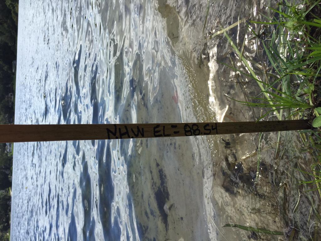
2 SECTION 2 - GENERAL INFORMATION Street Address: Tax Parcel ID Legal Description: Name of water body: Normal High Water Elevation (NHWE): msl Is the proposed dock? Please check one: Private Semi-Private Public What is the width of the shoreline (in linear feet), as measured at the NHWE? feet. What is the size of proposed terminal platform? square feet. [See Chapter 15; Article IX; Section (b)] Are you requesting a variance? Yes No Are you requesting a waiver? Yes No If yes, provide section Number: 15- (example: ) and describe the nature of the variance and/or waiver request: Note applications for a waiver and/or variance from the boat dock ordinance will require the completion of a separate waiver and/or variance application and may require additional fees. If you have questions, please call EPD for assistance. Brief Description of proposed work: Are there docks on the abutting properties? Yes No Are there any access restrictions to the property (locked gate/loose dogs): REQUIRED ATTACHMENT(S) CHECKLIST: Satisfactory evidence of title. (Example: copy of property deed). Documentation showing riparian rights for the parcel. A copy of a survey, to scale, of the real property which accurately depicts current conditions. Four (4) copies of a site plan depicting the exact location of the proposed dock, and shall include the following: An arrow indicating the northerly direction of the scale to which the sketch or drawing was prepared. The name of the water body upon which the proposed dock structure or renovation is to be located. The exact distance between the shoreline and a permanent object or construction. The exact setback distance from adjacent property lines and projected property lines to all portions of the dock. The floor and roof elevations of the proposed or existing dock. The current water depth at the end of the proposed or existing dock, and at all proposed mooring locations. The length of the proposed or existing dock, as measured from the NHWE to the point most waterward of the NHWE. Revised Page 2 of 5

3

4
5 SECTION 3 Name and Address of adjacent property owners: Name: Address: City: State Zip Name: Address: City: State Zip NOTICE TO APPLICANTS: The proposed dock structure may require a permit from either the Florida Department of Environmental Protection or the applicable Water Management District. In addition to public regulations which Orange County enforces, be advised that there may be other private restrictions or approval requirements that will affect your ability to erect this structure. Please review your deed restrictions and/or consult with your Homeowner s Association or Architectural Review Board. Revised Page 4 of 5
6 APPLICATION TO CONSTRUCT A BOAT DOCK APPLICATION FOR WAIVER (Pursuant to Orange County Code, Chapter 15, Article IX, Section (a)(2)) Mail or Orange County Environmental Protection Division Deliver To: 800 Mercy Drive, Suite 4 Orlando, Florida (407) , Fax (407) I on behalf of (if applicable) pursuant to Orange County Code Chapter 15, Article IX, Section (a)(2) am requesting a waiver to section (choose and circle from the following: (b), (b), (a) and (a)) of the Orange County Dock Construction Ordinance. 1. Describe how this waiver would not negatively impact the environment: 2. Describe the effect of the proposed waiver on abutting shoreline owners: The environmental protection officer and the board may require of the applicant information necessary to carry out the purposes of this article. By signing and submitting this application form, I am applying for a waiver to the Section indicated of the Orange County Dock Construction Ordinance identified above, according to the supporting data and other incidental information filed with this application. I am familiar with the information contained in this application, and represent that such information is true, complete, and accurate. I understand this is an application and not a permit, and that work conducted prior to approval is a violation. I understand that this application and any permit issued pursuant thereto, does not relieve me of any obligation for obtaining any other required federal, state, or local permits prior to commencement of construction. I understand that knowingly making any false statements or representation in this application is a violation of Sections & , Orange County Code. Name of Applicant: Signature of Applicant/Agent Date: Corporate Title (if applicable): Application for Boat Dock Waiver Rev
7 AfterRecording Returnto: MarkBennett DOC# 20 First Service Title offlorida, LLC / : LeeRoad Șuite405 Deed Do 8.5g Page WinterPark,FL ThisInstrument Prepared by: Pl speag MarkBennett p05an0 First Service Title offlorida, LLC 6 Countyni To: ComPtroller #IRST SER 2699LeeRoad Șuite405 1 VICE TITLE OF FL WinterPark,FL32789 I asa necessary incident tothefulfillment ofconditions contained ina title insurance commitment issuedbyit. PropertyAppraisersParcelI.D.(Folio)Number(s): FileNo.: WARRANTY DEED This Warranty Deed, Made the 15thday ofapril,2014, by Edward Tyler Simpson and Marcia Lynn Swenson, individuallyand CO-Trustees of the Ed Simpson and Lynn Swenson Revocable Trust, Dated July 9,2010, as husband and wife,whose postofficeaddress is:506 LillianDrive,Orlando, FL 32806, hereinafter calledthe"grantor"țocharles J. Blakleyand Jessica L. Blakley,as husband and wife,whose post officeaddress is: 506 LillianDrive,Orlando, FL 32806, hereinaftercalledthe "Grantee". WITNESSETH: Thousand That saidgrantor,forand inconsideration ofthesum offour Hundred Eighty Dollarsand No Cents ($480,000.00)and othervaluableconsiderations, receiptwhereof is herebyacknowledged,herebygrants,bargainsșells,aliens,remises,releases,conveys and confirms untothegrantee,allthatcertainlandsituateinorange County,Floridațowit: SEE EXHIBIT "A"ATTACHED HERETO The propertyisthehomestead ofthegrantor(s). TOGETHER withallthe tenements,hereditamentsand appurtenancestheretobelongingor in anywise appertaining. To Have and to Hold,thesame infeesimpleforever. And thegrantorherebycovenantswithsaidgranteethatthegrantoris lawfully seizedofsaidlandinfee simple;thatthegrantorhas good right and lawfulauthoritytoselland convey saidland;thatthegrantor hereby fullywarrantsthe titleto said land and willdefend the same againstthe lawfulclaimsof all personswhomsoever; and thatsaidlandisfreeofallencumbrances, excepttaxesaccruingsubsequent to2013, reservations, restrictions and easements ofrecord,ifany. (Theterms"Grantor" and"grantee" hereinshall beconstrued toinclude allgendersandsingular orplural asthecontext indicates.) IN WITNESS WHEREOF, Grantorhas hereuntoset Grantor'shand and sealthe day and year first above written. SiGNEDINTHE PRESENCE OF THE FOLLOWING WITNESSES TWO SEPARATE DISINTER ITNESSES REQUIRED Witness Signature: EDWARD TYLER SIMPSON RCIA LYNN PrintedName: SWENSON, INDIVIDUAL AND C -TRUSTEES OF THE IMPSON D LY SWENSON REV E T AT JULY 9,2010 %#ard Tyl son / indivduall n -Truste Marcia Lynn Swenson individually and CO-Trustee WitnessSignature PrintedName: StateofFlorida County oforange The foregoinginstrumentwas acknowledged beforeme this15thday ofapril,2014 by Edward Tyler Simpson and MarciaLynn Swenson, individually and CO-TrusteesoftheEd Simpson and Lynn Swenson RevocableTrust,Dated July9,2010, as husband and wife,who is/are personally known tome orhas/ have pr ce license(s) as identification. My Commission Expires: NotaryPublicSign ure ( PrintedName arkbennett
8 EXHIBIT "A" LEGAL DESCRIPTION Lot46,The Lillian Barnum Sub-division, accordingtotheplatthereof,recordedinplatbook "M",Page 99 ofthe PublicRecords oforange County,Florida,and beginatthesouthwestcornerofsaidlot46,the Lillian Barnum Sub-division, as recordedinplatbook "M",Page 99,ofthe PublicRecords oforange County,Florida;runSouth 5 Chains from saidpointofbeginningintolake JennieJewel,runthenceEast inwatersoflake JennieJewel 75 feet;thencerun North5 Chains tothesoutheastcornerofsaidlot46, The Lillian Barnum Sub-division; thencewest alongthesouth lineofsaidlot46,a distanceof75 feetto thepointofbeginning;beingpartoflot16,allotmentofthe Randolph Lands FortGatlin,as recordedin PlatBook "C",Page 58,ofthe PublicRecords oforange County,Florida.
9
10


. 6. PROPERTY HEREON LOCATED IN ZONE \" X & AE \" PER F.I.R.M. MAP PANEL NO. 12095C 0430 F DATED 09-25-09.")
11 2.0'± 0.6'± 1.8'± 15.0' 0.8'± 5.3' 18.2' 2.7'± 12.4' 44.4' 15.1' 4' 4.0' 90.2' 90.0' 0.3'± NOTES: 1. THIS SURVEY WAS PREPARED FROM TITLE INFORMATION FURNISHED TO THIS SURVEYOR. THERE MAY BE OTHER RESTRICTIONS OR UNRECORDED EASEMENTS THAT AFFECT THIS PROPERTY. PROPERTIES ARE SUBJECT TO COVENANTS, RESTRICTIONS, EASEMENTS AND SETBACKS OF RECORD. 2. NO UNDERGROUND IMPROVEMENTS HAVE BEEN LOCATED UNLESS OTHERWISE SHOWN. SEPTIC IF SHOWN IS +/-. 3. THIS SURVEY IS PREPARED FOR THE SOLE BENEFIT OF THOSE CERTIFIED TO AND SHOULD NOT BE RELIED UPON OR USED BY ANY OTHER ENTITY. 4. DIMENSIONS SHOWN FOR THE LOCATION OF IMPROVEMENTS HEREON SHOULD NOT BE USED TO RECONSTRUCT BOUNDARY LINES. BOUNDARY BEARINGS AND DISTANCES ARE SHOWN AS PLATTED UNLESS DENOTED AS MEASURED. 5. BEARINGS ARE BASED ON ASSUMED DATUM AND ON THE LINE SHOWN AS BASE BEARING (BB). 6. PROPERTY HEREON LOCATED IN ZONE " X & AE " PER F.I.R.M. MAP PANEL NO C 0430 F DATED RESIDENCE HEREON LOCATED IN ZONE " X " PER F.I.R.M. MAP PANEL NO C 0430 F DATED BUILDING LINES SHOWN, REPRESENT BUILDING WALLS. EAVES, IF ANY, NOT LOCATED OR SHOWN. Boundary And Mapping Associates, Inc. 109 WEST ORANGE STREET ALTAMONTE SPRINGS, FL PH. (407) LAND SURVEYORS LB 4565 DESCRIPTION: Lot 46, The Lillian Barnum Sub-division, according to the plat thereof, recorded in Plat Book "M", Page 99 of the Public Records of Orange County, Florida, and begin at the Southwest corner of said Lot 46, The Lillian Barnum Subdivision, as recorded in Plat Book "M", Page 99, of the Public Records of Orange County, Florida; run South 5 Chains from said point of beginning into Lake Jennie Jewel, run thence East in waters of Lake Jennie Jewel 75 feet; thence run North 5 Chains to the Southeast corner of said Lot 46, The Lillian Barnum Sub-division; thence west along the South line of said Lot 46, a distance of 75 feet to the point of beginning; being part of Lot 16, allotment of the Randolph Lands Fort Gatlin, as recorded in Plat Book "C", Page 58, of the Public Records of Orange County, Florida R E G I S T E R E D CERTI R O D N E Y 25' This is a digitally signed and sealed drawing of a boundary survey performed under the direction of the undersigned. Six copies are authorized on or about the date of the survey shown hereon and certified only to those persons and/or entities listed hereon The boundary survey meets the minimum techinal standards as set forth by the Florida Board of Professional Surveyors and Mappers in Chapter 5J-17 F.A.C. pursuant to section Florida statutes. RODNEY W. JACKSON, PSM 6281 Not valid without the signature and the original raised seal of a Florida licensed surveyor and mapper. JOB NO.: DATE: FIELD: SIGNED: DRAWN BY: RWJ P.C.: RP F L O S W FI U R CHECKED BY: RWJ I V J CATE No STATE OF R DA A C K S & E Y O R O N A P M E R P STREET R/W 75.00'(P) LOT 45 Column 1.4' Off 90 20'50''(M) 90 25'00"(P) S 0 20'50''W '(M) '(P) REC 2" I.P. NO # SW CORNER OF LOT '(D) EDGE OF PAVEMENT REC 1 1/4" I.P. NO # X X X X X X X X X X X X 0.7'± X X X X X X X X X X X X X X 20.4' 6.5' 6.2' 97'± (M) TO WATER N 90 00'00''W 75.16'(M) 75'(P) 20.6' 2.4' X CARPORT 2.4' 4.5' 1.7' 20.6' 2.3' 1.6' 20.4' 24.0' C/L LILLIAN DRIVE 14.4' 30.4' X 22.4' RESIDENCE # 506 SCREENED PATIO 23.0' 11.9' NORMAL HIGH WATER ELEVATION WOOD DECK STEPS COVERED PROPOSED DOCK BLOCK WALL W/COLUMNS LOT 46 AC AC METAL SHED NO CONCRETE 75.09'(M) 75'(D) APPROXIMATE EDGE OF WATER ' 7.6' 5.5' 10.5' 80''± (M) TO WATER X X X X X X X X X X X X X X X X X X X X X X X X X X X 89 38'10''(M) 89 35'00"(P) 22.1' 21.6' LAKE JENNIE JEWEL Part of Lot 16, Allotment of the Randolph Lands Fort Gatlin, 75'(D) S. LINE LOT ' P.P. REC 1 1/4" I.P. NO # N 0 21'50''E '(M) '(P) 25' REC 2" I.P. NO # SE CORNER OF LOT '(D) LOT 47 Property Address: 506 LILLIAN DRIVE SCALE 1" = 40' CERTIFIED TO: CHARLES J. BLAKLEY AND JESSICA L. BLAKLEY TRUSTCO BANK FIRST SERVICE TITLE OF FLORIDA, LLC STEWART TITLE GUARANTY COMPANY LEGEND Add distance from Dock To Line: ORDERED BY: First Service Title of Florida 1755 W Broadway St Oviedo, FL Phone: (407) CONCRETE PAVERS / REC. - RECOVERED BRICK I.P. - IRON PIPE PRC- POINT OF REVERSE CURVE I.C. - ILLEGIBLE CAP # R.P. - RADIUS POINT C.M. - CONCRETE MONUMENT R - RADIUS RB - REBAR L - LENGTH OF ARC RAD. - RADIAL S.E. - SIDEWALK EASEMENT N.R. - NOT RADIAL U.E.- UTILITY EASEMENT N&D - NAIL & DISC D.E.- DRAINAGE EASEMENT (P) - PER PLAT L.E.- LANDSCAPE EASEMENT (M) - AS MEASURED P.E.- POOL EQUIPMENT (D) - PER DESCRIPTION P.P.- POWER POLE O.L. - ON LINE X - CHAIN LINK / WIRE FENCE P.C. - POINT OF CURVATURE WOODEN FENCE P.T. - POINT OF TANGENCY - VINYL FENCE R/W - RIGHT-OF-WAY A - ALUMINUM FENCE
12
13
APPLICATION TO CONSTRUCT A DOCK
 APPLICATION TO CONSTRUCT A DOCK (In Accordance with Orange County Code Chapter 15, Article IX, Orange County Code) Mail or Orange County Environmental Protection Division Deliver To: 3165 McCrory Place,
APPLICATION TO CONSTRUCT A DOCK
 APPLICATION TO CONSTRUCT A DOCK (In Accordance with Orange County Code Chapter 15, Article IX, Orange County Code) Mail or Orange County Environmental Protection Division Deliver To: 800 Mercy Drive, Suite
ORAN le C UNTY GOVERNMENT FLORID A APPLICATION TO CONSTRUCT A DOCK
 ORAN le APPLICATION TO CONSTRUCT A DOCK C UNTY GOVERNMENT ( FLORID A (In Accordance with Orange County Code Chapter 15, Article IX, Orange County Code) Mail or Orange County Environmental Protection Division
APPLICATION TO CONSTRUCT A DOCK
 APPLICATION TO CONSTRUCT A DOCK (In Accordance with Orange County Code Chapter 15, Article IX, Orange County Code) Mail or Orange County Environmental Protection Division Deliver To: 800 Mercy Drive, Suite
OgAz.- 4,E C sunty GOVERNMENT FLORIDA APPLICATION TO CONSTRUCT A DOCK
 OgAz.- 4,E C sunty GOVERNMENT FLORIDA APPLICATION TO CONSTRUCT A DOCK (In Accordance with Orange County Code Chapter 15, Article IX, Orange County Code) Mail or Orange County Environmental Protection Division
ORAN 1E UNTY GOVERN1'IENT F 10121D APPLICATION TO CONSTRUCT A DOCK
 ORAN 1E UNTY GOVERN1'IENT F 10121D APPLICATION TO CONSTRUCT A DOCK (In Accordance with Orange County Code Chapter 15, Article IX, Orange County Code) Mail or Orange County Environmental Protection Division
Palm Ave Hialeah Building Data Palm Avenue
 400-450 Palm Ave Hialeah Building Data Address 400-450 Palm Avenue City, State Hialeah, Florida County Miami Dade parcel # 04-3118-001-1950 and 1960 Zoning Retail Commercial - BU2 Land Size 13500 Type
APPLICATION FOR CLEARANCE OF SHORELINE VEGETATION AND
 APPLICATION FOR CLEARANCE OF SHORELINE VEGETATION AND CONSERVATION AREA AUTHORIZATION* *This permit application is intended to be used when work is being proposed both within a conservation area or easement
CITY OF PORT ST LUCIE
 CITY OF PORT ST LUCIE COUNCIL AGENDA MEMORANDUM Agenda Item #: 11B Meeting Date: 5/22/17 TO: Mayor and City 1Council 2 VIA: Russ Blackburrit, ity Manager Patricia Roeblirg, P.E., Assistant City Manager
C unly GOVERNMENT FLORIDA APPLICATION TO CONSTRUCT A DOCK. (In Accordance with Orange County Code Chapter 15, Article IX, Orange County Code)
") C unly GOVERNMENT FLORIDA APPLICATION TO CONSTRUCT A DOCK (In Accordance with Orange County Code Chapter 15, Article IX, Orange County Code) Mail or Orange County Environmental Protection Division Deliver
C unly GOVERNMENT FLORIDA APPLICATION TO CONSTRUCT A DOCK (In Accordance with Orange County Code Chapter 15, Article IX, Orange County Code) Mail or Orange County Environmental Protection Division Deliver
APPLICATION TO CONSTRUCT A DOCK. (In Accordance with Orange County Code Chapter 15, Article IX, Orange County Code) SECTION 1
 SECTION 1") ORAN E C UNT1 v GOVERNMENT liorin A APPLICATION TO CONSTRUCT A DOCK (In Accordance with Orange County Code Chapter 15, Article IX, Orange County Code) Mail or Orange County Environmental Protection Division
ORAN E C UNT1 v GOVERNMENT liorin A APPLICATION TO CONSTRUCT A DOCK (In Accordance with Orange County Code Chapter 15, Article IX, Orange County Code) Mail or Orange County Environmental Protection Division
PLAT OF SURVEY VICINITY MAP (NOT TO SCALE) N N W E SITE BENCHMARK # 2 W E N&D ON BACK OF CURB NAVD 88 S S 0' 10' 20' 40' 60' 1" = 20' TOP=106.7
 N N W E SITE BENCHMARK # 2 W E N&D ON BACK OF CURB NAVD 88 S S 0' 10' 20' 40' 60' 1 = 20' TOP=106.7") PLAT OF SURVEY VICINITY MAP (NOT TO SCALE) N N W E SITE BENCHMARK # 2 W E N&D ON BACK OF CURB 106.21 NAVD 88 S S 0' 10' 20' 40' 60' 1" = 20' TOP=106.72 N INV PVC=99.27 S INV PVC=99.32 E INV CLAY=99.39
PLAT OF SURVEY VICINITY MAP (NOT TO SCALE) N N W E SITE BENCHMARK # 2 W E N&D ON BACK OF CURB 106.21 NAVD 88 S S 0' 10' 20' 40' 60' 1" = 20' TOP=106.72 N INV PVC=99.27 S INV PVC=99.32 E INV CLAY=99.39
Sketch & Legal Description of Mitigation Bank and Ingress/Egress Access Easements
 Appendix H: Sketch & Legal Description of Mitigation Bank and Ingress/Egress Access Easements Tippen Bay Wetland Mitigation Bank DeSoto County, Florida Prepared by: September, 2017 Original file
Environmental and Engineering Services EASEMENT INFORMATION AND EXAMPLE DOCUMENTS
 Environmental and Engineering Services Reddy Chitepu, P.E., Director EASEMENT INFORMATION AND EXAMPLE DOCUMENTS Please refer to the information below when compiling easement documents for submittal to
WATERFORD LANDING COMMUNITY DEVELOPMENT DISTRICT REGULAR MEETING AGENDA
 WATERFORD LANDING COMMUNITY DEVELOPMENT DISTRICT REGULAR MEETING AGENDA January 31, 2019 Waterford Landing Community Development District OFFICE OF THE DISTRICT MANAGER 2300 Glades Road, Suite 410W Boca
STANDARDIZED LEGAL DESCRIPTIONS AND EXHIBITS
 STANDARDIZED LEGAL DESCRIPTIONS AND EXHIBITS Public Works Department, Engineering Division June 14, 2004 UNIFIED GOVERNMENT STANDARDIZED LEGAL DESCRIPTIONS AND EXHIBITS For: Roads, Bridges, Short Span
SKETCH OF BOUNDARY SURVEY ALTA / ACSM LAND TITLE SURVEY
 SKETCH OF BOUNDARY SURVEY ALTA / ACSM LAND TITLE SURVEY SURVEYOR'S NOTES: All distances as shown hereon are based on the US Survey foot. Subject property lies inside the UBD (Urban Development Boundary),
SUBMITTAL REQUIREMENTS: The number indicates the number of copies for submittal (if applicable).
.") Office Use Only Preliminary Long Plat Long Subdivision Applicant Checklist PLANNING, COMMUNITY, & ECONOMIC DEVELOPMENT DEPARTMENT PRELIMINARY LONG PLAT LONG SUBDIVISION CHECKLIST Mailing Address: P.O.
Office Use Only Preliminary Long Plat Long Subdivision Applicant Checklist PLANNING, COMMUNITY, & ECONOMIC DEVELOPMENT DEPARTMENT PRELIMINARY LONG PLAT LONG SUBDIVISION CHECKLIST Mailing Address: P.O.
SUBMITTAL REQUIREMENTS: The number indicates the number of copies for submittal (if applicable).
.") Office Use Only Preliminary Long Plat Long Subdivision Applicant Checklist PLANNING, COMMUNITY, & ECONOMIC DEVELOPMENT DEPARTMENT FINAL LONG PLAT LONG SUBDIVISION CHECKLIST Mailing Address: P.O. Box 547,
Office Use Only Preliminary Long Plat Long Subdivision Applicant Checklist PLANNING, COMMUNITY, & ECONOMIC DEVELOPMENT DEPARTMENT FINAL LONG PLAT LONG SUBDIVISION CHECKLIST Mailing Address: P.O. Box 547,
AIR ONE. 829 HULL ROAD Ormond Beach, Florida BENCHMARK #1 EL NAIL IN POWER POLE EASTERLY RIGHT-OF-WAY LINE TOMOKA AIRPORT ROAD (UR) HULL ROAD
 HULL ROAD") NORTH LINE LOT 2 SOUTH LINE LOT 1 S75 46'55"E 2 NORTH LINE LOT 3 SOUTH LINE LOT 2 N75 43'32"W(UR) S75 43'32"E(D) N75 43'32"W(URD) NORTH LINE LOT 1 SOUTH LINE LOT 12 225.15'(M)225'(UR) P.O.R. PARCELS II
NORTH LINE LOT 2 SOUTH LINE LOT 1 S75 46'55"E 2 NORTH LINE LOT 3 SOUTH LINE LOT 2 N75 43'32"W(UR) S75 43'32"E(D) N75 43'32"W(URD) NORTH LINE LOT 1 SOUTH LINE LOT 12 225.15'(M)225'(UR) P.O.R. PARCELS II
APPLICATION FOR FINAL PLAT APPROVAL (Major Subdivision)
") APPLICATION FOR FINAL PLAT APPROVAL (Major Subdivision) CITY OF HOSCHTON, GA PLANNING AND DEVELOPMENT 79 City Square Hoschton, GA 30548 706-654-3034 Applicant Information: Name: Address: City, State, Zip:
APPLICATION FOR FINAL PLAT APPROVAL (Major Subdivision) CITY OF HOSCHTON, GA PLANNING AND DEVELOPMENT 79 City Square Hoschton, GA 30548 706-654-3034 Applicant Information: Name: Address: City, State, Zip:
Form 11.A.9.17 INSTRUCTIONS FOR APPLICATION FOR PLAT WAIVER (Art. 11.A.8)
") Form 11.A.9.17 INSTRUCTIONS FOR APPLICATION FOR PLAT WAIVER (Art. 11.A.8) All questions in each part must be completed. When a question is not applicable to the property, enter "N/A" or other phrase indicating
Form 11.A.9.17 INSTRUCTIONS FOR APPLICATION FOR PLAT WAIVER (Art. 11.A.8) All questions in each part must be completed. When a question is not applicable to the property, enter "N/A" or other phrase indicating
CITY OF LEE S SUMMIT MINOR PLAT PROCESS. Purpose of Minor Plats
 MINOR PLAT PROCESS Purpose of Minor Plats The City of Lee s Summit requires that all property be platted before a building permit is issued. Platting involves the subdivision of land into lots or tracts.
PLANNING DIRECTOR. Approved by the Planning Director on this day of, A.D. 20. day of, A.D. 20. Approved by the Fire Chief on this
 Located in a portion of the West Half of Section 19, Township 5 South, Range 1 East, Salt Lake Base and Meridian. SURVEYOR'S CERTIFICATE I, the undersigned surveyor, do hereby certify that I am a registered
ATTACHMENT B GRANT DEED. This deed is in satisfaction of the Eminent Domain Action Case No. GRANT DEED
 GRANT DEED RECORDING REQUESTED BY AND WHEN RECORDED MAIL TO: County of Orange County Executive Office CEO Real Estate 333 W. Santa Ana Blvd. Bldg. 10 Santa Ana, California 92701 AND MAIL TAX STATEMENTS
INSTRUCTIONS FINAL PLAT APPROVAL APPLICATION
 INSTRUCTIONS FINAL PLAT APPROVAL APPLICATION 1. The applicant/agent shall fill out the attached application. The attached application form must be completely filled in before it can be filed. Portions
BUILDING & INSPECTIONS DIVISION 200 East Wood Street Palatine, IL Telephone (847)
") 2018 EXPRESS PERMIT APPLICATION PAVER DRIVEWAY PRINT CLEARLY. ILLEGIBLE AND/OR INCOMPLETE APPLICATIONS WILL BE RETURNED (this is a two sided application) Property/Owner Information check if applicant Project
2018 EXPRESS PERMIT APPLICATION PAVER DRIVEWAY PRINT CLEARLY. ILLEGIBLE AND/OR INCOMPLETE APPLICATIONS WILL BE RETURNED (this is a two sided application) Property/Owner Information check if applicant Project
SUBDIVISION APPLICATION
 SUBDIVISION APPLICATION Preliminary Plat Minor Plat Final Plat Amended Plat Applicant Name: Owner (if different from applicant) Name: Company: Company: Address: Address: City, State, Zip City, State, Zip
ABBREVIATION LEGEND SITE INFORMATION:
 SITE INFORMATION: Current Zone: R-3 PUD, governed by Fox Hollow 2nd MDA Basis of Elevations: Northeast Corner of Section 13, T6S, R1W, S.L.B. & M Elevation: 4599.26 (Benchmark) ABBREVIATION LEGEND Owners:
COMMERCIAL AND MULTI-USE DOCK PERMIT APPLICATION PINELLAS COUNTY WATER AND NAVIGATION
 Direct all correspondence to: Clerk, Water and Navigation, 5 th Floor 315 Court Street Clearwater, FL 33756 COMMERCIAL AND MULTI-USE DOCK PERMIT APPLICATION I. PROPERTY OWNER INFORMATION: PINELLAS COUNTY
UNTY ORIN GOVERNMENT APPLICATION TO CONSTRUCT A DOCK. Name: Mail or Deliver To: SECTION 1 OWNER(S) OF THE LAND
 OF THE LAND") ORIN UNTY GOVERNMENT rlori A APPLICATION TO CONSTRUCT A DOCK (In Accordance with Orange County Code Chapter 15, Article IX, Orange County Code) Mail or Deliver To: Orange County Environmental Protection
ORIN UNTY GOVERNMENT rlori A APPLICATION TO CONSTRUCT A DOCK (In Accordance with Orange County Code Chapter 15, Article IX, Orange County Code) Mail or Deliver To: Orange County Environmental Protection
QUEBEC STREET EAST 130TH AVENUE ONEIDA STREET E. 130TH AVE. VALENTIA ST TAMARAC ST EAST 128TH AVENUE MOACO STREET BACHMAN DR. SITE QUINCE ST.
 SHEET OF CASE NO.: SUBA - PURPOSE STATEMENT: THIS PLAT IS INTENDED TO SUBDIVIDE. ACRES INTO SINGLE FAMILY LOTS, AND TRACTS FOR PARKS, OPEN SPACE, DRAINAGE AND DETENTION, DEDICATE RIGHT-OF-WAY AND GRANT
FINAL PLAT APPLICATION
 FINAL PLAT APPLICATION (Page 1 of 3) LEGAL OWNER(s): NAME: STREET ADDRESS OWNER(s): CITY, STATE, ZIP CODE: PHONE NUMBER: BILLING ADDRESS: NAME OF ENGINEER/SURVEYOR: Engineer/Surveyor Address, Phone: PROPERTY
Map Filing Law. 46: Effective date This act shall take effect January first, one thousand nine hundred and fiftyfour.
 46:23-9.8. Effective date This act shall take effect January first, one thousand nine hundred and fiftyfour. L.1953, c. 358, p. 1941, s. 8. 46:23-9.9. Short title This act shall be known and may be cited
COUNTY OF ADAMS, STATE OF COLORADO E. 40TH AVE. TOWER RD. E. 38TH AVE. SALIDA ST. HIGH LINE CANAL PROJECT LOCATION E. 32ND PKWY.
 LEGAL DESCRIPTION:, GATEWAY EAST AT TOWER SUBDIVISION FILING NO. 1, SAID PARCEL CONTAIN 598,154 SQUARE FEET OR MORE OR LESS GENERAL NOTES: 1. NOTICE: ACCORDING TO COLORADO LAW YOU MUST COMMENCE ANY LEGAL
EXHIBIT 3 Page 1 of 6
 Page 1 of 6 08-TE.11-06/98 This instrument prepared under the direction of: Laurice C. Mayes, Esq. Sketch and Legal Description prepared by: Pete Diaz. P.S.M. (04-09-13) Document prepared by: Grace K.
City of Port St. Lucie PLANNING & ZONING DEPARTMENT
 City of Port St. Lucie PLANNING & ZONING DEPARTMENT EXEMPTION FROM PLATTING Section: 156.022 Process Fill out: Exemption From Platting Application Form. See Fee Schedule for fee. Submit to Planning & Zoning
APPLICATION FOR FINAL PLAT APPROVAL
 APPLICATION FOR FINAL PLAT APPROVAL Section 1. General. The undersigned Applicant (Applicant is synonymous with owner) makes this Application for Final Plat Approval in accordance with Chapter 21, Port
AGENDA REQUEST AGENDA ITEM NO: IV.A.2. Consent Agenda No. 1. June 4, 2018 BY Development Services Timothy Litchet City Engineer DavisShaw SUBJECT:
 AGENDA HEADING: Consent Agenda No. 1 AGENDA REQUEST COMMISSION MEETING DATE: June 4, 2018 BY Development Services Timothy Litchet City Engineer DavisShaw AGENDA ITEM NO: IV.A.2. Originating Department
GENERAL WARRANTY DEED
 PROJECT. # 89008160 TRACT NO.:10 PARCEL ID NO.:PL199032200000001003 OWNERS NAME: Park Hill School District SITUS ADDRESS:5520 N. Northwood: KANSAS CITY, MISSOURI MAILING ADDRESS:7703 NW Barry Rd. Kansas
FENCE PERMIT APPLICATION
 FENCE PERMIT APPLICATION DATE: PERMIT FEE: $60.00 Submit (2) sets of drawings and data required to assure compliance with the provisions of the zoning code. Drawings must include a site plan dawn to scale
DISTRICT. Huntington Beach. FIM 40-40C-3 APN and
 RECORDING REQUESTED BY W HEN RECORDED MAIL TO SOUTHERN CALIFORNIA EDISON COMPANY 2131 WALNUT GROVE AVENUE 2 ND FLOOR GO3 ROSEMEAD, CA 91770 Attn: Title and Real Estate Services SPACE ABOVE THIS LINE FOR
PLANNING AND DEVELOPMENT DEPARTMENT PRELIMINARY PLAT APPLICATION
 PLANNING AND DEVELOPMENT DEPARTMENT PRELIMINARY PLAT APPLICATION IT IS INCUMBENT UPON THE APPLICANT TO SUBMIT COMPLETE AND CORRECT INFORMATION. ANY MISLEADING, DECEPTIVE, INCOMPLETE OR INCORRECT INFORMATION
NON-EXCLUSIVE ROADWAY AND UTILITY EASEMENT DEED AND AGREEMENT
 RETURN TO: STOGSDILL LAW OFFICE, P.C. 505 West Main, Suite 313 Lewistown, Montana 59457 (406) 538-2623 NON-EXCLUSIVE ROADWAY AND UTILITY EASEMENT DEED AND AGREEMENT THIS EASEMENT DEED AND AGREEMENT is
Oakland County Michigan Register of Deeds Plat Engineering, GIS, & Remonumentation Dept. Ph: (248) Fax (248)
 Fax (248)") Oakland County Michigan Register of Deeds Plat Engineering, GIS, & Remonumentation Dept. Ph: (248)-858-1447 Fax (248)-858-7466 Requirements Needed for Final Plat Approval No. General Requirements. 1 Routing
Oakland County Michigan Register of Deeds Plat Engineering, GIS, & Remonumentation Dept. Ph: (248)-858-1447 Fax (248)-858-7466 Requirements Needed for Final Plat Approval No. General Requirements. 1 Routing
QUEBEC STREET EAST 130TH AVENUE ONEIDA STREET E. 130TH AVE. VALENTIA ST TAMARAC ST EAST 128TH AVENUE MONACO STREET BACHMAN DR. SITE QUINCE ST.
 SHEET OF CASE NO.: SUBA 0-0 PURPOSE STATEMENT: THIS PLAT IS INTENDED TO SUBDIVIDE. ACRES INTO 0 SINGLE FAMILY LOTS, AND TRACTS FOR PARKS, OPEN SPACE, DRAINAGE AND DETENTION, DEDICATE RIGHT-OF-WAY AND GRANT
CERTIFIED SURVEY MAP
 SCONSIN STATE PLANE N:389676.12 E:2130390.15 Center of Section 23 CERTIFIED SURVEY MAP 734.06' THE (PRITCHETTE) ORIGINAL PLAT OF ALL IN THE NW 1 4 OF THE SE 1 4 OF FRACTIONAL SECTION 23, T7N, R9E, IN THE
[] Workshop
![[] Workshop](/thumbs/95/123671251.jpg "[] Workshop") PALM BEACH COUNTY BOARD OF COUNTY COMMISSIONERS AGENDA ITEM SUMMARY Agenda Item #: 1/C. ---------------------------------------------------------------- ----------------------------------------------------------------
PALM BEACH COUNTY BOARD OF COUNTY COMMISSIONERS AGENDA ITEM SUMMARY Agenda Item #: 1/C. ---------------------------------------------------------------- ----------------------------------------------------------------
MtU of Nort4 Port. Resolution No.: 2011-R-32. Page 1 of 3 RESOLUTION NO R-32
 Resolution No.: 2011-R-32 4 F oo,~ly Title: Emerald Oaks R-O-W to Easement W o ~ N ti OR% MtU of Nort4 Port RESOLUTION NO. 2011-R-32 (A Resolution for non-enforcement of the reverter clause in Petition
Dallas Sloan General Manager Barron Area Phone: (715) Toll Free: Fax: (715) NEW SERVICE PROCESS
 Toll Free: Fax: (715) NEW SERVICE PROCESS") Barron Area Phone: (715) 537-3171 Toll Free: 800-322-1008 Fax: (715) 637-1906 Dallas Sloan General Manager NEW SERVICE PROCESS Paperwork: Membership application social security number required for credit
Barron Area Phone: (715) 537-3171 Toll Free: 800-322-1008 Fax: (715) 637-1906 Dallas Sloan General Manager NEW SERVICE PROCESS Paperwork: Membership application social security number required for credit
MINOR PLAT FILING APPLICATION
 FILING APPLICATION Date of PC Meeting: Date of BCC Meeting: Fee Paid: 1. APPLICANT: DAYTIME PHONE: MAILING ADDRESS: LANDOWNER: DAYTIME PHONE: MAILING ADDRESS: AUTHORIZED AGENT: MAILING ADDRESS: RELATIONSHIP
EASEMENT DEED. 2) Thence N 60º12 36 W through said Parcel 1 a distance of Two Hundred Ninety- Five and 97/100 (295.97) feet to a point;
 Thence N 60º12 36 W through said Parcel 1 a distance of Two Hundred Ninety- Five and 97/100 (295.97) feet to a point;") EASEMENT DEED TALL TREES CONSTRUCTION CORP., a Maine corporation having a mailing address of 30 Preservation Drive, Falmouth, Maine 04105 (the "Grantor") for consideration paid, grants to the TOWN OF FALMOUTH,
EASEMENT DEED TALL TREES CONSTRUCTION CORP., a Maine corporation having a mailing address of 30 Preservation Drive, Falmouth, Maine 04105 (the "Grantor") for consideration paid, grants to the TOWN OF FALMOUTH,
LANDSCAPE AND MAINTENANCE EASEMENT. THIS LANDSCAPE AND MAINTENANCE EASEMENT, (hereinafter Easement )
") Prepared by and return to: Parcel ID # LANDSCAPE AND MAINTENANCE EASEMENT THIS LANDSCAPE AND MAINTENANCE EASEMENT, (hereinafter Easement ) is made and entered into this day of, 2009, by and between THIRD
Prepared by and return to: Parcel ID # LANDSCAPE AND MAINTENANCE EASEMENT THIS LANDSCAPE AND MAINTENANCE EASEMENT, (hereinafter Easement ) is made and entered into this day of, 2009, by and between THIRD
PUBLIC NOTICE SALE OF COUNTY OWNED SURPLUS REAL PROPERTY
 PUBLIC NOTICE SALE OF COUNTY OWNED SURPLUS REAL PROPERTY Notice is hereby given that the Pasco County Board of County Commissioners will receive sealed bids to purchase the following surplus County-owned
MINOR PLAT. The following documents are provided as required by the City of Conroe for use in the above titled platting submittals:
 Public Works - Engineering Division CITY OF CONROE MINOR PLAT The following documents are provided as required by the City of Conroe for use in the above titled platting submittals: Submittal Questionnaire
APPLICATION FOR MAJOR SUBDIVISION APPROVAL (FINAL PLAT)
") 209 S. Main Street Marysville, Ohio 43040 Phone: (937) 645-7350 Fax: (937) 645-7351 www.marysvilleohio.org APPLICATION FOR MAJOR SUBDIVISION APPROVAL (FINAL PLAT) *** IMPORTANT INFORMATION ~ Please read
209 S. Main Street Marysville, Ohio 43040 Phone: (937) 645-7350 Fax: (937) 645-7351 www.marysvilleohio.org APPLICATION FOR MAJOR SUBDIVISION APPROVAL (FINAL PLAT) *** IMPORTANT INFORMATION ~ Please read
AFFIDAVIT FENCE OFFICE OF THE JACKSON TOWNSHIP ZONING DEPARTMENT P. O. BOX 517 GROVE CITY, OH 43123
 AFFIDAVIT FENCE OFFICE OF THE JACKSON TOWNSHIP ZONING DEPARTMENT P. O. BOX 517 GROVE CITY, OH 43123 STATE OF OHIO ) COUNTY OF FRANKLIN ) ss (Name) being first duly cautioned and sworn, according to law
PRELMINARY PLAT CHECKLIST
 PRELMINARY PLAT CHECKLIST A. All preliminary plat submitted for approval shall be prepared by a Registered Professional Land Surveyor. B. Preliminary plats must be drawn to a scale of XXX with such accuracy
MINOR SUBDIVISION APPLICATION
 Planning and Development 510 N. Baker St. Mount Dora, FL 32757 352-735-7112 Fax: 352-735-7191 plandev@cityofmountdora.com Date: Project Name: MINOR SUBDIVISION APPLICATION 1. Applicant s Name: 2. Property
Planning. the propertyy. Texas Local. Government. Code. size of 2,0000 RSF-2-PUD. Road within the Wharf at a. Citizen. 0 Letter of. 1.
 Planning & Zoning Commissionn Replat Phase I of the Wharf at Clear Lake, Dock 18, Slips 1 and 2 Planning & Development Department February 15, 20166 Request Replat approximately 0.0209 acres of a previouslyy
SUBMITTAL REQUIREMENTS
 PRELIMINARY PLAT APPLICATION ***A PRE-APPLICATION MEETING WITH CITY STAFF IS REQUIRED FOR THIS APPLICATION*** DATE STAMP FOR CITY USE ONLY PROJECT NAME (if any): TO BE FILLED OUT BY APPLICANT PROJECT STREET
SUBDIVISION APPLICATION: RECOMBINATION PLAT or EXEMPT PLAT
 SUBDIVISION APPLICATION: RECOMBINATION PLAT or EXEMPT PLAT Pursuant to Article 7, Section 155.706 of the Unified Development Code, an owner of land within the jurisdiction of the Town (or a duly authorized
, AS THE OWNER(S) OF THE REAL AS FOLLOWS,, DO HEREBY AGENT (PRINT AGENT'S NAME),
 OF THE REAL AS FOLLOWS,, DO HEREBY AGENT (PRINT AGENT'S NAME),") AGENT AUTHORIZATION FORM FOR PROJECTS LOCATED IN ORANGE COUNTY, FLORIDA I/WE, (PRINT PROPER TY OWNER NAME) Patrick or Lauren Walker, AS THE OWNER(S) OF THE REAL PROPERTY DESCRIBED AS FOLLOWS,, DO HEREBY
AGENT AUTHORIZATION FORM FOR PROJECTS LOCATED IN ORANGE COUNTY, FLORIDA I/WE, (PRINT PROPER TY OWNER NAME) Patrick or Lauren Walker, AS THE OWNER(S) OF THE REAL PROPERTY DESCRIBED AS FOLLOWS,, DO HEREBY
Fence Checklist. Permit application and supporting documents. 2. Notarized, Owner/Builder Affidavit (if applicable).
.") Village of Royal Palm Beach, Florida Community Development Department, Building Division 1050 Royal Palm Beach Boulevard Royal Palm Beach, Florida 33411 Telephone (561) 790-5128 Fax (561) 790-5129 Fence
Village of Royal Palm Beach, Florida Community Development Department, Building Division 1050 Royal Palm Beach Boulevard Royal Palm Beach, Florida 33411 Telephone (561) 790-5128 Fax (561) 790-5129 Fence
ORAN E. h r AGENT AUTHORIZATION FORM FOR PROJECTS LOCATED IN ORANGE COUNTY, FLORIDA. n 00 Print Narte Property Owner GOVERNMENT FL O R I D A
 AGENT AUTHORIZATION FORM FOR PROJECTS LOCATED IN ORANGE COUNTY, FLORIDA UWE, PROPERTY (IPRINT Shir ley Cannon 5 Main Street, Windermere AUTHORIZE TO ACT AS MY/OUR Sheila Cichra PROPE RTY OWNER NAME), AS
CITY OF BEVERLY HILLS Department of Public Works and Transportation Civil Engineering Division FINAL MAP SUBMITTAL PROCESS Transmitted
 CITY OF BEVERLY HILLS Department of Public Works and Transportation Civil Engineering Division FINAL MAP SUBMITTAL PROCESS Transmitted From To* Planning Department Civil Engineering Division RKA Consulting
CONSENT ACTION BY THE BOARD OF DIRECTORS OF VENETO IN MIRAMAR CONDOMINIUM ASSOCIATION, INC.
 CONSENT ACTION BY THE BOARD OF DIRECTORS OF VENETO IN MIRAMAR CONDOMINIUM ASSOCIATION, INC. The undersigned, being all of the members of the Board of Directors of Veneto in Miramar Condominium Association,
CONTRACT FOR SALE AND PURCHASE
 CONTRACT FOR SALE AND PURCHASE THIS CONTRACT FOR SALE AND PURCHASE ("Agreement") is entered into on this day of, 20, by and between BROWARD COUNTY, a political subdivision of the State of Florida ("COUNTY''
MEMORANDUM. Mayor and City Council. Warren Hutmacher, City Manager. Date: February 11, 2013
 MEMORANDUM To: From: Mayor and City Council Warren Hutmacher, City Manager Date: February 11, 2013 Subject: Approval of an Intergovernmental agreement by and between the City of Dunwoody and DeKalb County
MARTIN COUNTY BOARD OF COUNTY COMMISSIONERS
 MARTIN COUNTY BOARD OF COUNTY COMMISSIONERS DOUG SMITH Commissioner, District 1 UTILITIES & SOLID WASTE DEPARTMENT PO Box 9000 Stuart, FL 34995-9000 John E. Polley Director Phone (772) 221-1442 Fax (772)
Standards of Practice for Surveying in the State of Alabama
 Standards of Practice for Surveying in the State of Alabama Effective January 1, 2017 RULE NO. 1.01 PURPOSE The purpose of these rules is to establish standards for the practice of surveying in the State
GeoPoint 1403 E. 5th Avenue Tampa, Florida
 AIRPORT ROAD PINELAND P.R.D. SUBDIVISION - PHASE 1 DEDICATION: CERTIFICATE OF REVIEW BY SURVEYOR, CITY OF ORMOND BEACH DEDICATION: THIS IS TO CERTIFY THAT FORESTAR (USA) REAL ESTATE GROUP INC., A DELAWARE
GREENWAY EASEMENT AGREEMENT
 GREENWAY EASEMENT AGREEMENT This greenway access easement is entered into by and between the Laramie County School District Number One ( Grantor ), a corporate body organized under the laws of the State
TOWN OF EASTCHESTER BUILDING AND PLANNING DEPARTMENT PLANNING BOARD APPLICATION PACKAGE SUBDIVISIONS
 TOWN OF EASTCHESTER BUILDING AND PLANNING DEPARTMENT 40 Mill Road (914) 771-3317 building@eastchester.org Eastchester, NY 10709 (914) 771-3322 Fax www.eastchester.org TABLE OF CONTENTS PLANNING BOARD APPLICATION
BOSSIER CITY PARISH METROPOLITAN PLANNING COMMISSION 620 Benton Rd. Bossier City, LA Phone: Fax: PRELIMINARY PLAT
 (OFFICE USE ONLY) Application Fee: Paid: Date: CASE # Project Information BOSSIER CITY PARISH METROPOLITAN PLANNING COMMISSION 620 Benton Rd. Bossier City, LA 71111 Phone: 318-741-8824 Fax: 318-741-8827
PERMANENT DEEP TUNNEL EASEMENT AGREEMENT
 PERMANENT DEEP TUNNEL EASEMENT AGREEMENT Project Number: 75918 Project Name: Three Rivers Protection & Overflow Reduction Tunnel [3RPORT] Cross Reference Document(s): Deed Record F, page 481; Deed Book
The following is required for a complete permit submittal.
 THE CITY OF LAKE FOREST COMMUNITY DEVELOPMENT DEPARTMENT 800 N. FIELD DRIVE, LAKE FOREST, IL 60045 P: (847)810-3511 OR (847)810-3502, F: (847)615-4383 WWW.CITYOFLAKEFOREST.COM DRIVEWAY PERMIT REQUIREMENTS
MARTIN COUNTY BOARD OF COUNTY COMMISSIONERS
 MARTIN COUNTY BOARD OF COUNTY COMMISSIONERS DOUG SMITH Commissioner, District 1 UTILITIES & SOLID WASTE DEPARTMENT PO Box 9000 Stuart, FL 34995-9000 John E. Polley Director Phone (772) 221-1442 Fax (772)
APPLICATION FOR VARIANCE Chapter 50, Land Development Code Levy County, Florida
 Filing Date: Petition Number: Fee: $ 350.00 Validation Number: TO THE LEVY COUNTY BOARD OF ADJUSTMENT AND CODE ENFORCEMENT: A Variance is to grant relief to a person from the requirements of this Ordinance
APPLICATION BOARD OF ZONING ADJUSTMENT (BZA) VARIANCE, SPECIAL EXCEPTION, AND APPEAL OF ZONING MANAGER S DETERMINATION
 VARIANCE, SPECIAL EXCEPTION, AND APPEAL OF ZONING MANAGER S DETERMINATION") ORANGE COUNTY ZONING DIVISION 201 South Rosalind Avenue, 1 st Floor, Orlando, Florida 32801 Phone: (407) 836-3111 Email: ZoningInternetMail@ocfl.net www.orangecountyfl.net APPLICATION BOARD OF ZONING ADJUSTMENT
ORANGE COUNTY ZONING DIVISION 201 South Rosalind Avenue, 1 st Floor, Orlando, Florida 32801 Phone: (407) 836-3111 Email: ZoningInternetMail@ocfl.net www.orangecountyfl.net APPLICATION BOARD OF ZONING ADJUSTMENT
GeoPoint 213 Hobbs Street Tampa, Florida
 AIRPORT ROAD PINELAND P.R.D. SUBDIVISION - PHASES 2 & 3 DESCRIPTION: A parcel of land lying in Sections 13 and 24, Township 14 South, Range 31 East, Volusia County, Florida, and being more particularly
SUBDIVISION APPLICATION CHECKLIST SKETCH PLAN PRELIMINARY PLAT FINAL PLAT
 RECEIVED STAMP SUBDIVISION APPLICATION CHECKLIST SKETCH PLAN PRELIMINARY PLAT FINAL PLAT A checklist of background information and submission requirements for processing of a sketch plan, preliminary plat
SHEET 1 of 13 RECORDING REQUESTED BY AND WHEN RECORDED, RETURN TO: S&S CONTRACTORS, INC VENTURA BLVD., # 104 WOODLAND HILLS, CA 91364
 SHEET 1 of 13 RECORDING REQUESTED BY AND WHEN RECORDED, RETURN TO: S&S CONTRACTORS, INC. 22817 VENTURA BLVD., # 104 WOODLAND HILLS, CA 91364 CONDOMINIUM PLAN CONSISTING OF LOT 1 OF TRACT NO. 65890 IN THE
FINAL PLAT. Community Development Department 8101 Ralston Road Arvada, Colorado 80002
 FINAL PLAT Community Development Department 8101 Ralston Road Arvada, Colorado 80002 September 2015 FINAL SUBDIVISION PLAT Final Subdivision Plat Review Applications for a Final Plat shall be submitted
LAND USE PERMIT APPLICATION
 LAND USE PERMIT APPLICATION Date Application No. TYPE OF PERMIT Subdivision Short Plat Conditional Use Binding Site Plan Final Plat Final Short Plat Variance Final Binding Site Plan Plat Amendment Short
VICINITY MAP SCALE 1'' = 2000'
 CITY CREEK ANNEXATION TO THE CITY OF THORNTON LOCATED IN THE SOUTHWEST QUARTER OF SECTION 11 AND THE WEST HALF OF SECTION 14, TOWNSHIP 1 SOUTH, RANGE 68 WEST OF THE 6TH PRINCIPAL MERIDIAN, COUNTY OF ADAMS,
CITY OF FAYETTEVILLE, ARKANSAS FINAL PLAT FOR STAFF USE ONLY FINAL PLAT FEE: $ $ Date Application Submitted: Date Accepted as Complete:
 CITY OF FAYETTEVILLE, ARKANSAS FINAL PLAT FOR STAFF USE ONLY FINAL PLAT FEE: $200.00-$800.00 Date Application Submitted: Date Accepted as Complete: Project Number: Public Hearing S-T-R: PP#: Zone: Please
Planning & Zoning Commission Staff Report for Honey Bee Acres Subdivision, SD-PH
 Planning & Zoning Commission Staff Report for Honey Bee Acres Subdivision, SD-PH2018-0009 Hearing Date: August 16, 2018 Development Services Department Applicant: Kelley & Carrie Dick Staff: Kyle McCormick,
FENCES BUILDING PERMIT APPLICATION
 Community Development 17 Montrose Drive Romeoville, IL 60446-1329 (815) 886-7203 (815) 372-4039 Email: buildinginspections@romeoville.org FENCES BUILDING PERMIT APPLICATION Application Date / / Property
Application for a Deminimus Development
 Okeechobee County Community Development Department 1700 NW 9 th Avenue, Suite A Okeechobee, FL 34972 Phone (863) 763-5548 Fax (863) 763-5276 planning@co.okeechobee.fl.us A deminimus development is the
APPLICATION FOR LOT SPLIT
 APPLICATION FOR LOT SPLIT ELIGIBILITY Section 12.09.01 of the Land Development Code provides for review and approval of lot split, which shall include any of the following: 1. The division of a single
MINOR SUBDIVISION PLAT
 MINOR SUBDIVISION PLAT Community Development Department 8101 Ralston Road Arvada, Colorado 80002 MINOR SUBDIVISION PLAT Subdivisions consisting of five (5) or fewer lots are eligible for the minor subdivision
MINOR SUBDIVISION PLAT CHECKLIST
 MINOR SUBDIVISION PLAT CHECKLIST Project Name: Tax ID #: Project Number: Date: _ Reviewed By: Telephone: NOTES: All lots on septic systems must comply with the Fulton County Health Department requirements
MINOR SUBDIVISION PLAT
 MINOR SUBDIVISION PLAT Community Development Department 8101 Ralston Road Arvada, Colorado 80002 September 2015 MINOR SUBDIVISION PLAT Subdivisions consisting of five (5) or fewer lots are eligible for
DECLARATION OF RESTRICTIVE COVENANTS (AGE RESTRICTED)
") Return recorded copy to: Development and Environmental Regulation Division 115 S. Andrews Avenue, A240 Fort Lauderdale, FL 33301 Document prepared by: DECLARATION OF RESTRICTIVE COVENANTS (AGE RESTRICTED)
Return recorded copy to: Development and Environmental Regulation Division 115 S. Andrews Avenue, A240 Fort Lauderdale, FL 33301 Document prepared by: DECLARATION OF RESTRICTIVE COVENANTS (AGE RESTRICTED)
Application for Conservation Area Impact Permit
 Application for Conservation Area Impact Permit (In accordance with Orange County Code Chapter 15 Article X, Orange County Code) Mail or Orange County Environmental Protection Division Deliver To: 3165
Minor Subdivision Application
 FOR PLANNING USE ONLY Application # SD Application Fee $1,000.00 Receipt No. Filing Date Completeness Date Minor Subdivision Application A. PROJECT INFORMATION 1. Project Name: 2. Address of Subject Property:
Copies Date No. Description
 Transmittal Date: Thursday, September 20, 2018 To: From: Mr. Amede Dimonnay, MBA Broward County Environmental Protection and Growth Management Department Environmental Engineering and Permitting Division
I. Requirements for All Applications. C D W
 108-16.1. Application checklists. Checklist for Required Submissions to the Planning Board or Zoning Board of Adjustment of Monroe Township All required submissions are to be made to the Administrative
SUBDIVISION APPLICATION INSTRUCTIONS
 SUBDIVISION APPLICATION INSTRUCTIONS APPLICATION FORM The application form must be fully completed, signed by the property owner and shall be properly notarized. AGENT AUTHORIZATION FORM If the applicant