STAFF REPORT. Applicable Statutes/Ordinances: Corinna Township Subdivision Ordinance
|
|
|
- Philip Garrison
- 5 years ago
- Views:
Transcription
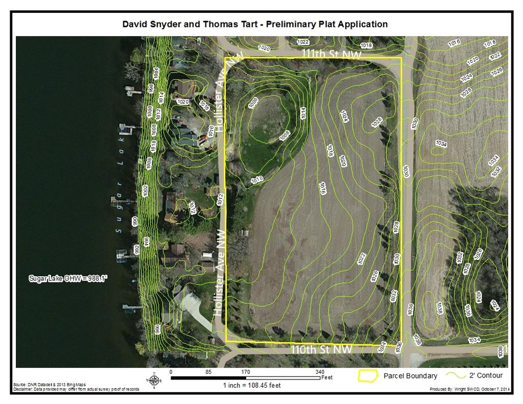
1 STAFF REPORT Application: Preliminary plat application to subdivide an approximate 6.47 acre parcel into two lots (2.81 and 3.42 acres) with a 0.24 acre remainder to be attached to an existing nonconforming lakeshore lot. Applicant: David Snyder and Thomas Tart Agenda Item: 4(d) Background Information: Proposal: Subdivide approximately 6.47 acres into two residential lots (2.81 and 3.42 acres) and a remainder 0.24 acre parcel that would be attached to an existing nonconforming lakeshore lot of record. Location: o Property address: Parcel east of and Hollister Ave NW, Annandale o Sec/Twp/Range: o Parcel number(s): Zoning: Suburban Residential (R2) /Residential Recreation Shorelands (S-2) Overlay District, Sugar Lake (General Development lake) Lot size: Approximately 6.47 acres to be subdivided into two residential lots (2.81 and 3.42 acres) and a remainder 0.24 acre parcel that would be attached to an existing nonconforming lakeshore lot of record. Septic System Status: Each proposed lot would be required to install a new septic system. The applicant has not submitted soil borings and preliminary location information. Natural Features: Floodplain: The property is not within an identified floodplain. Bluff/Steep Slopes: There are not any steep slopes of bluffs on the property to be subdivided. The land slopes fairly gently toward the NW corner of the property, where water appears to collect after heavy rains but eventually soaks into the ground. Wetlands: There do not appear to be any wetlands on the property, although the NW corner is low and does collect water during periods of heavy rain. Applicable Statutes/Ordinances: Corinna Township Subdivision Ordinance 1.2 Purposes. These regulations are adopted for the following purposes: 1. To guide the future growth and development of Corinna Township in recognition of the general policies embodied in the Corinna Township Corinna Township 4(d) - 1 October 14, 2014
2 Comprehensive Plan and protect and provide for the public health, safety, and general welfare of the Township. 2. To ensure that land to be subdivided shall be of such character that it can be used safely for building purposes without danger to health or peril from fire, flood, or other menace. Land shall not be subdivided until adequate public services and facilities exist with sufficient capacity to serve the proposed subdivision. 3. To protect and conserve the value of land throughout the Township and the value of buildings and improvements upon the land, and to minimize the conflicts among the uses of land and buildings. 4. To establish reasonable standards of design and procedures for subdivisions and resubdivisions in order to further the orderly layout and use of land, including the proper location and width of streets and building lines, and to ensure proper legal descriptions and monumenting of subdivided land. 5. To ensure that proper provision has been made for drainage, water, sewage, and public improvements such as parks, recreational facilities, transportation facilities, and improvements. The community will be required to bear no more than its fair share of the cost of providing facilities and services through requiring the developer to pay fees, furnish land, or establish mitigation measures to ensure that the development provides its fair share of capital facilities needs generated by the development. 6. To prevent the pollution of air and water resources including ground water and to encourage the wise use and management of natural resources throughout the Township in order to preserve the integrity, stability, and beauty of the community and the value of the land. 7. To provide for open spaces through the most efficient design and layout of the land. 8. To remedy problems associated with inappropriately subdivided lands. 4.2 Standard Plat A. Preliminary Plat Approval Process for Plats Consisting of Two or More Lots iii. The Platting Committee and Planning Commission shall consider, but not be limited to, the following criteria when considering a preliminary plat: 1. The preliminary plat shall conform to all applicable official controls and all state and federal laws. 2. The preliminary plat shall be consistent with the Corinna Township Comprehensive Plan. 3. No plat shall be approved which does not conform to any applicable floodplain regulations. 4. No plat shall be approved unless there is provision for two (2) standard on-site sewage treatment systems for each lot, unless served with public sewer or an approved cluster sewer system serving lots within the subdivision. Corinna Township 4(d) - 2 October 14, 2014
3 5. A plat shall not be approved where a variance will subsequently be required in order to use the lots for their intended use. 6. No plat shall be approved that does not contain adequate provisions for storm water runoff. If required, no plat shall be approved without an NPDES Phase II-compliant storm water management plan reviewed and approved by the Township or its designated representative. 7. Each lot shall have sufficient buildable lot area which, for the purposes of this Ordinance, shall be defined as the contiguous area of a lot which is sufficient in area to accommodate the construction of water supply systems, sewage treatment systems, buildings and driveways, while still providing for adequate setbacks. Areas which are floodways, wetlands, rights-of-way, bluffs or which have soils that are unsuitable for individual sewage treatment systems cannot be included in calculating the buildable area of a lot. 8. Each lot shall be of sufficient size and character to meet applicable sewage treatment system standards 9. When deemed appropriate by the Zoning Administrator or the Planning Commission, the subdivider shall provide a vegetative buffer adjacent to delineated wetlands and/or wetlands identified on the National Wetland Inventory Map. 10. The Planning Commission shall consider whether the plat as proposed adequately protects the health, safety and welfare of the residents of the Township by providing for safe and adequate drinking water supply, adequate sewage treatment capacity, safe road access, proper road alignment and proper setbacks and buffering from conflicting land uses. 6.1 General. The following principles, standards and requirements will be applied by the Township in evaluating proposed subdivisions. These are the minimum principles, standards and requirements for the promotion and protection of the public health, safety, morals, and general welfare and shall not preclude the Township from requiring stricter standards or requirements when the conditions merit: 1. Community context. Proposed subdivisions shall be coordinated with existing nearby development so that the community as a whole may develop harmoniously based on the minimum standards of this Ordinance. 2. Comprehensive plan. Proposed subdivisions shall be designed in recognition of the general policies included in the Corinna Township Comprehensive Plan. 3. Land/soil suitability. Land that the Township finds to be unsuitable for subdivision or development due to flooding, improper drainage, steep Corinna Township 4(d) - 3 October 14, 2014
4 slopes, rock formations, adverse earth formations or topography, utility easements, or other features that will reasonably be harmful to the safety, health, and general welfare of the present or future inhabitants of the subdivision and/or its surrounding areas, shall not be subdivided or developed unless adequate methods are formulated by the developer and approved by the Township Board to solve the problems created by the unsuitable land conditions. Such land shall be set aside for uses as shall not involve any danger to public health, safety, and welfare. The following areas are unsuitable for development: a. Flood Plain Areas. No land shall be subdivided in designated flood plain areas or areas that may be subject to flooding unless the proposed subdivision complies with the standards of the Federal Emergency Management Agency (FEMA), complies with Wright County or State of Minnesota Floodplain regulations and is proposed in combination with buildable areas. b. Wetlands. Wetlands or wetland buffer areas, as defined and classified under the Wetland Conservation Act of 1991, shall not be included in calculating the square footage of the buildable area on any lot. 4. Agriculturally Important Lands. a. The Planning Commission may consider the values of agriculturally important lands when making its recommendation on a plat. The Land Capability Classification System and Crop Equivalency Ratios of the Natural Resources Conservation Service (NRCS) shall be used as guides to determine if agriculturally important lands are within a proposed subdivision. b. In making its recommendation, the Planning Commission may take into consideration, but not be limited to, the following criteria or designated areas: i. Farmability of Parcel. The size, shape, slope, soil quality, topographic limits and vegetative cover. ii. Proximity. Proximity to an urbanizing area or in proximity to conforming non-agricultural uses. iii. Compatibility with Surrounding Uses. Compatibility or separation by distance or screening with surrounding uses. iv. Distance from Agricultural Operations. Located near an existing animal or commercial feedlot as defined in Wright County or State of Minnesota regulations. v. Shoreland Areas. Sensitive areas such as shorelands, vi. bluffs and wetlands are considered. Man-Made or Physical Barriers. Man-made or physical features act as barriers. 5. Conformance to Applicable Rules and Regulations. In addition to the requirements established in these regulations, all subdivision plats shall comply with the following laws, rules, and regulations unless a variance is granted: Corinna Township 4(d) - 4 October 14, 2014
5 a. Any applicable Township ordinance, engineering standards and all other applicable laws of the Township. b. Any adopted official maps, public utilities plans, Public Capital Improvement Programs, or other adopted plans or programs of the Township. c. All applicable statutory provisions. d. The requirements and rules of the Minnesota Health Department, Minnesota Department of Natural Resources, the Minnesota Department of Transportation, the Minnesota Pollution Control Agency or other applicable state or federal agencies. 6. Self-Imposed Restrictions. If the developer places restrictions on any of the land contained in the subdivision greater than those required by the Zoning Ordinance or these regulations, such restrictions or reference to those restrictions shall be recorded in the Developer s Agreement. 7. Adequate Public Facilities. No preliminary plat shall be approved unless the Township Board determines that public facilities will be adequate to support and service the area of the proposed subdivision. Public facilities shall include roads, electric utilities, telecommunications, stormwater, sanitary sewer (when located in any sanitary sewer district), gas or other energy service, or other public services necessary to serve the development as determined by the Township Board. 8. Debris and Waste. No cut trees, timber, or other organic materials of any kind shall be buried in any land, or left or deposited on any lot or street in the subdivision except as approved by the Township. If approved, all areas intended to be used for burying debris shall be shown and noted on the preliminary plat. Areas proposed for the burying of debris shall not be located in or affect the following; buildable areas, driveways, wells, utilities, or drainfield sites.. No debris or waste shall be left in any area of the subdivision at the time of expiration of any developer s agreement or dedication of public improvements. Corinna Township Zoning Ordinance 505. CONDITIONAL USE PERMITS Criteria for Granting Conditional Use Permits In granting a conditional use permit, the Wright County Planning Commission shall consider the effect of the proposed use upon the health, safety, morals, and general welfare of occupants of surrounding lands. Among other things, the County Planning Commission shall make the following findings where applicable. (1) That the Conditional Use will not be injurious to the use and enjoyment of other property in the immediate vicinity for the purposes already Corinna Township 4(d) - 5 October 14, 2014
6 permitted, nor substantially diminish and impair property values within the immediate vicinity; (2) That the establishment of the Conditional Use will not impede the normal and orderly development and improvement of surrounding vacant property for uses predominant in the area; (3) That adequate utilities, access roads, drainage and other necessary facilities have been or are being provided; (4) That adequate measures have been or will be taken to provide sufficient off-street parking and loading space to serve the proposed use; (5) The use is not in conflict with the Policies Plan of the County; and, (6) That adequate measures have been taken or will be taken to prevent or control offensive odor, fumes, dust, noise, and vibration, so that none of these will constitute a nuisance, and to control lighted signs and other lights in such a manner that no disturbance to neighboring properties will result Additional Conditions In permitting a new conditional use or the alteration of an existing conditional use, the Planning Commission may impose, in addition to these standards and requirements expressly specified by this Ordinance, additional conditions which the Planning Commission considers necessary to protect the best interest of the surrounding area or the community as a whole. These conditions may include, but are not limited to the following: (1) Increasing the required lot size or yard dimension. (2) Limiting the height, size or location of buildings. (3) Controlling the location and number of vehicle access points. (4) Increasing the street width. (5) Increasing the number of required off-street parking spaces. (6) Limiting the number, size, location or lighting of signs. (7) Requiring diking, fencing, screening, landscaping or other facilities to protect adjacent or nearby property. (8) Designating sites for open space. Corinna Township 4(d) - 6 October 14, 2014
7 Any change involving structural alterations, enlargements, intensification of use, or similar change not specifically permitted by the Conditional Use Permit issued shall require an amended Conditional Use Permit and all procedures shall apply as if a new permit were being issued. The Wright County Zoning Administrator shall maintain a record of all conditional use permits issued including information on the use, location, and conditions imposed by the Planning Commission; time limits, review dates, and such other information as may be appropriate SUBURBAN RESIDENTIAL R Purpose The major purpose of this District is to allow for a "rural life-style" by permitting low-density residential development in areas that are marginal or non-feasible for agriculture Conditional Uses Subdivisions - a 2 ½ acre minimum lot subdivision in areas designated as such in the land use plan. Corinna Township Comprehensive Plan The Corinna Township Comprehensive Plan (adopted in 2007) classifies the property and most of the surrounding properties as appropriate for a future land use of Rural Preservation, which is described as: Rural Preservation: A land use designation for properties that are best suited for rural farmsteads and farming. This classification would be most consistent with the Wright County Agricultural zoning classification. The Township believes it prudent to respond to future growth pressure by considering low-density, rural residential development in these areas, utilizing a cluster-style development strategy to maintain the rural character of the community. Wright County Comprehensive Plan The Wright County Comprehensive Plan, just adopted in 2009, classifies the property as appropriate for Residential Large Lot, which is described as: Residential Large Lot Primarily designates those areas that have already been converted to a rural/suburban, residential environment with lot sizes ranging from two to ten acres due to past decisions. Undeveloped lands that are surrounded or nearly surrounded by such patterns may also be included in this district. Existing land types may include large wooded areas, non-productive farmland near existing developed areas, infill on lands near highly developed lakeshore areas and other areas where large lot development may occur without Corinna Township 4(d) - 7 October 14, 2014
8 posing a threat to the environment, or long term agricultural uses. Appropriate zoning may include Agricultural, Agricultural Residential, R-2(a) and, in special cases, R-2. Rezoning from Agricultural to residential districts will generally be considered appropriate for large lot (R-2a) proposals and for smaller sizes (R-2) in cases where existing development trends or environmental factors are appropriate. Rezoning to R-1 will only be considered for riparian lots on shorelands especially suited to that type of residential development, or for small areas of "infill" which are predominately R-1 already. Staff Findings (Subdivision Criteria): We propose the following findings for consideration by the Planning Commission, based on the criteria for reviewing subdivision applications in the Corinna Township Subdivision Ordinance: 1. The preliminary plat shall conform to all applicable official controls and all state and federal laws. The proposed lots meet all requirements for size, width and depth in the R-2 zoning district. All lots exceed the minimum width of 200 feet, minimum depth of 300 feet and the minimum lot size of 2.5 acres. The remainder lot could be allowed subject to approval as a lot line adjustment. 2. The preliminary plat shall be consistent with the Corinna Township Comprehensive Plan. The Comprehensive Plan states that these properties are in an area best suited for rural farmsteads and farming. The Plan states that the Township believes it prudent to respond to future growth pressure by considering low-density, rural residential development in these areas, utilizing a cluster-style development strategy to maintain the rural character of the community. The proposed plat, resulting in a 2.81 and 3.42 acre lot is likely to maintain the rural character of the community. The subdivision, which is in land which as been farmed historically, but is not of a size that is typical for most farmland, should not have a significant impact on continued farming in the area. Several goals within the Comprehensive Plan apply to the proposal. They include: Protect, preserve, and enhance lake water quality. o o Require on-site storm water retention and erosion-control plans for all new lakeshore development and redevelopment of existing sites to ensure that storm water runoff is properly managed and treated before entering surface waters. Limit the amount of grading and filling in the shoreland area so as to minimize the disturbance of soil and prevent erosion. Staff Comment: The applicant has not submitted plans that implement storm water management practices. However, the amount of land that would be altered to develop these lots residentially is not likely to rise to the level that would require a state permit for Corinna Township 4(d) - 8 October 14, 2014
9 stormwater controls and could be appropriately addressed during the actual construction/development process on the lots. The lots should not need a lot of topographic alteration to develop residentially. Encourage preservation of productive farm operations. o Require developments that may occur in or near productive farmland to design subdivisions in a way that preserves the greatest amount of productive farmland for continued agricultural use. Staff Comment: The subdivision would involve the conversion of land that is currently farmed to residential use. However, it will not have a significant impact on agricultural use of land in the broader area. If preserving this property for farmland were a significant concern, it likely would not have been approved for rezoning by the County. Ensure that all Township properties are adequately and efficiently treating sewage, both for current residents and expected future population growth. Staff Comment: The property would be required to show that there are two sewerable sites on each lot. While this information has not yet been submitted, the lots are large and the soils appear to be suitable for sewer systems. However, this should be confirmed by a licensed sewer designer prior to final plat approval. 3. No plat shall be approved which does not conform to any applicable floodplain regulations. This property is not located in any designated floodplain area. 4. No plat shall be approved unless there is provision for two (2) standard on-site sewage treatment systems for each lot, unless served with public sewer or an approved cluster sewer system serving lots within the subdivision. The proposed lots would be served with private sewer systems. Preliminary soil borings and locations for two septic systems per site should be presented prior to final plat approval. 5. A plat shall not be approved where a variance will subsequently be required in order to use the lots for their intended use. The proposed subdivision would not appear to create the need for any variances for the lots to be developed residentially. 6. No plat shall be approved that does not contain adequate provisions for storm water runoff. If required, no plat shall be approved without an NPDES Phase IIcompliant storm water management plan reviewed and approved by the Township or its designated representative. The plat, as proposed, does not appear to require a NPDES-Phase II stormwater management plan as it would not create more than one acre of new impervious. Corinna Township 4(d) - 9 October 14, 2014
10 No new roads are being constructed and each lot would only be expected to create about 10-15,000 sq ft of new impervious at the most. 7. Each lot shall have sufficient buildable lot area which, for the purposes of this Ordinance, shall be defined as the contiguous area of a lot which is sufficient in area to accommodate the construction of water supply systems, sewage treatment systems, buildings and driveways, while still providing for adequate setbacks. Areas which are floodways, wetlands, rights-of-way, bluffs or which have soils that are unsuitable for individual sewage treatment systems cannot be included in calculating the buildable area of a lot. The proposed plat does not identify areas for potential location of homes/garages or sewer systems. Given that the lots are all greater than 2.5 acres in size should provide more than adequate room for homes and sewer systems. The ability to provide two sewer sites on each lot should be confirmed prior to final plat approval. 8. Each lot shall be of sufficient size and character to meet applicable sewage treatment system standards. See answer for #4 above. 9. When deemed appropriate by the Zoning Administrator or the Planning Commission, the subdivider shall provide a vegetative buffer adjacent to delineated wetlands and/or wetlands identified on the National Wetland Inventory Map. There do not appear to be any wetlands on the property. 10. The Planning Commission shall consider whether the plat as proposed adequately protects the health, safety and welfare of the residents of the Township by providing for safe and adequate drinking water supply, adequate sewage treatment capacity, safe road access, proper road alignment and proper setbacks and buffering from conflicting land uses. Private wells and sewer would be used for these lots. The properties would each have Township road on three sides one of which is paved and the other two of which are gravel. A road would separate these two lots from the adjacent farmland to the east. Staff Findings (Conditional Use): The following findings of fact are presented by Staff for consideration by the Planning Commission: 1) Will the Conditional use be injurious to the use and enjoyment of other property in the immediate vicinity for the purposes already permitted, or substantially diminish and impair property values within the immediate vicinity? No. The proposed lot sizes are larger than the minimum 2.5 acres required and should not create any problems for the use and enjoyment of neighboring properties. Corinna Township 4(d) - 10 October 14, 2014
11 2) Will the establishment of the Conditional Use impede the normal and orderly development and improvement of surrounding vacant property for uses predominant in the area? No. See comment #1 in the CUP criteria above. 3) Do adequate utilities, access roads, drainage and other necessary facilities exist or will they be provided? Yes. The lots would be served by existing Township roads on three sides of each of the proposed lots. The road between these lots and Sugar Lake do not have defined ditches for drainage and any provision of ditches would not have an outlet to Sugar Lake except by running over the lakeshore lots in the area. 4) Have adequate measures been taken to provide sufficient off-street parking and loading space to serve the proposed use? Yes. The 2.5+ acre lots will provide more than adequate space for off-street parking. 5) Will the use conflict with the Policies Plan of Corinna Township and/or Wright County? See comment #2 in the Subdivision criteria above. 6) Have adequate measures been taken, or will they be taken, to prevent or control offensive odor, fumes, dust, noise, and vibration, so that none of these will constitute a nuisance, and to control lighted signs and other lights in such a manner that no disturbance to neighboring properties will result? Yes. The proposed project would not be expected to create any long-term or ongoing nuisance such as are listed above. 7) Are there any other conditions which the Planning Commission considers necessary to protect the best interest of the surrounding area or the community as a whole? Planning Commission Direction: The Planning Commission can approve the request, deny the request, or table the request if additional information is needed. If the decision is for approval or denial, findings of fact should be cited. Staff Recommendation: Based on the findings of fact presented in this report Staff recommends approval of the proposed subdivision (including the remainder 0.24 acre parcel), with the following conditions of that approval: 1. That the 0.24 acre parcel must be combined into one parcel number and legal description with Lots 1 and 2 of Sugar Lake Heights and the vacated portion of Mol Street (aka Hollister Avenue) that is already part of Parcel prior to final plat approval. 2. That the applicants must provide evidence from a licensed sewer designer that there exists at least two sewerable sites on each of the proposed residential lots prior to final plat approval. Corinna Township 4(d) - 11 October 14, 2014
12
13


14 Wright County, MN Date Created: 9/29/2014 Overview 226 ft Legend Roads CSAHCL CTYCL MUNICL PRIVATECL TWPCL City/Township Limits c t Parcels Water 2' Contours 842; 844; 846; 848; 852; 854; 856; 858; 862; 864; 866; 868; 872; 874; 876; 878; 882; 884; 886; 888; 892; 894; 896; 898; 902; 904; 906; 908; 912; 914; 916; 918; 922; 924; 926; 928; 932; 934; 936; 938; 942; 944; 946; 948; 952; 954; 956; 958; 962; 964; 966; 968; 972; 974; 976; 978; 982; 984; 986; 988; 992; 994; 996; 998; 1002; 1004; 1006; 1008; 1012; 1014; 1016; 1018; 1022; 1024; 1026; 1028; 1032; 1034; 1036; 1038; 1042; 1044; 1046; 1048; 1052; 1054; 1056; 1058; 1062; 1064; 1066; 1068; 1072; 1074; 1076; 1078; 1082; 1084; 1086; 1088; 1092; 1094; 1096; 1098; 1102; 1104; 1106; 1108; 1112; 1114; 1116; 1118; 1122; 1124; 1126; 1128; 1132; 1134;
15
16
 with.")
17 WRIGHT SOIL AND WATER CONSERVATION DISTRICT 311 Brighton Avenue Suite C Buffalo, MN Telephone: (763) (763) Fax: (763) October 7, 2014 Thomas & Constance Tart 1807 Timberline TRL Minnetonka, MN RE: Preliminary plat application to subdivide an approximate 6.47 acre parcel into two lots (2.81 and 3.42 acres) with.024 acre remainder to be attached to an existing nonconforming lakeshore lot. Dear Mr. & Mrs. Tart, The Wright Soil and Water Conservation District (SWCD) has reviewed and inspected the above mentioned property for preliminary plat application. The Wright SWCD appreciates the opportunity to comment on the preliminary plat application. The Wright SWCD would like to require review of all the building applications in the future development of this property. At that time more detailed comments on erosion and sediment control measures will be addressed on each individual lot per building request. Thank you for keeping in mind those items during future development and if you have any questions or comments please feel free to contact myself or the District. Kind Regards, Dan Nadeau Urban Conservation Specialist Cc: Corinna Township
18
19 STAFF REPORT Application: Request for a lot line adjustment between two nonconforming lots of record to transfer 5 ft of land from Lot 5, Shelmires and attach it to Lot 4, Shelmires. Applicant: Karl Enghauser Agenda Item: 4(e) Background Information: Proposal: The applicant is proposing to separate his two lots of record (Lots 4 and 5, Shelmires - originally platted in 1967), but also to take the southern five feet of Lot 5 and keep it with Lot 4. The lot line adjustment would provide an approximate 8 foot setback from the existing home on Lot 4 to the (proposed) lot line rather than the current approiximate 3 ft setback. It would reduce the lot width of Lot 5 from 105 ft to 100 ft at the lake. Location: o Property address: th Street NW o Sec/Twp/Range: o Parcel number(s): Zoning: Urban/Rural Transition (R1) /Residential Recreation Shorelands (S-2) Overlay District, Sugar Lake (General Development lake) Lot size: Approx acres (both lots combined); Approx acres (Lot 4 as originally platted); Approx. 28,314 sq ft (Lot 5 as originally platted); Approx 26,729 sq ft (Lot 5 as proposed). All measurements based on Beacon GIS estimates. Existing Impervious Coverage (Lot 4 as originally platted): Buildings: Approx. 4,000 sq ft (7.8%) Total: Approx. 8,500 sq ft (16.5%) Existing Impervious Coverage (Lot 5 as proposed): Buildings: Approx. 660 sq ft (2.5%) Total: Approx. 1,860 sq ft (7.0%) Septic System Status: Lot 4, with the existing home, has a 1985 sewer system that is in the process of being checked for compliance. Lot 5 has had preliminary septic design work completed and been found suitable for a Type I sewer system (mound). Natural Features: o o o Floodplain: The property is not within an identified floodplain. Bluff/Steep Slopes: The property does not contain any steep slopes or bluff. Wetlands: There appears to be a wetland on Lot 4 near the road, but it would not significantly impact the development of Lot 5. Corinna Township 4(e) - 1 October 14, 2014
20 Permit History: o x 64 dwelling o 1979 Septic system o 1985 Septic system Applicable Statutes/Ordinances: 404 LOTS OF RECORD Corinna Township/Wright County Regulations Lots of record in the office of the County Recorder prior to the effective date of this Ordinance may be allowed as residential building sites provided: (1) They have frontage on an existing public right-of-way or have frontage on an existing easement or other private roadway existing prior to January 1, (2) They have at least 20,000 square feet of area. Lots smaller than 20,000 square feet may be used as dwelling sites if the owner can prove that adequate sanitary facilities can be provided. Said sanitary facilities must be located on the same lot of record as the dwelling, or on adjacent land which is legally available to the owner. Extraordinary alteration of the lot through land filling or excavation shall not constitute proof of an adequate site for sanitary facilities Other Duties of the Board of Adjustment (2) Lot Line Adjustments The Board of Adjustment may review lots of record in the office of the County Recorder which do not meet standards established by this Ordinance for size, width, elevation, depth, or other provisions. The Board may require that such parcels be joined, combined, modified in size, shape, or other ways to more nearly achieve the standards of this Ordinance if the owner wishes to use such parcels as building sites. The Board may initiate such proceedings or may act upon request of the property owner. If the Board determines that the lot is not acceptable as a building site, the Zoning Administrator shall provide a copy of the Board s findings to the Wright County Assessor URBAN/RURAL TRANSITIONAL R Performance Standards (5) Lot Area Regulations: (a) For dwelling units with private on-site sewage treatment systems water wells - one (1) acre. Corinna Township 4(e) - 2 October 14, 2014
21 (6) Lot Width and Depth Regulations: (a) For dwelling units with private sewage treatment systems: Lot Width feet (200 feet in shoreland classified as Natural Environment). Lot Depth feet. (7) Structures may be so located on each lot such that subdivision is possible when central sewer and water facilities become available. Findings of Fact: The following findings of fact are presented by Staff for consideration by the Board of Adjustment: 1. Will the proposed lot line adjustment result in the standards of the Zoning Ordinance being more nearly achieved? a) Needs discussion. The proposed alteration of the lot lines will obviously make Lot 5 smaller than it is now. However, Lot 5 (as adjusted) would still meet the minimum requirements of the DNR for lakeshore lots on a General Development lake (100 ft wide, 20,000 sq ft), can have a Type I sewer system installed, and meets the requirements of Section 404. It appears that a reasonably sized home could also be built on Lot 5 (as adjusted) while still meeting the 15% building and 25% overall impervious limits. Perhaps most relevantly, the proposed adjustment would improve the side yard setback of the existing home from the originally platted lots lines from about 3 feet to about 8 feet (min. 15 ft required). So long as Lot 4 either has an existing compliant sewer system, or can have such a system installed, it would appear that the proposed alteration will on balance more nearly achieve the standards of the Zoning Ordinance at least in terms of the side yard setback for the existing home. Board of Adjustment Direction: The Board of Adjustment may approve the variance request, deny the request(s), or table the request(s) if the Board should need additional information from the applicant. If the Board should approve or deny the request, the Board should state the findings which support either of these actions. Staff Recommendation: Based on the findings of fact and discussion above, Staff recommends that the Board approve the proposed lot line adjustment upon the following conditions: 1. That the applicant provides evidence that Lot 4 (with the existing home) is already, or will be, served with a compliance sewer system. 2. (For discussion) That the applicant provides evidence that both of the proposed lots have space for two Type I sewer drainfields. Corinna Township 4(e) - 3 October 14, 2014
22
23
24
25
26
27

28
29
STAFF REPORT. Arthur and Kathleen Quiggle 4(b)
") STAFF REPORT Application: Requests related to the construction of a 28' x 41' dwelling and 6' wrap-around open deck to replace an existing 24' x 32' cabin and wrap-around open deck and the installation
STAFF REPORT Application: Requests related to the construction of a 28' x 41' dwelling and 6' wrap-around open deck to replace an existing 24' x 32' cabin and wrap-around open deck and the installation
STAFF REPORT. Permit History:
 STAFF REPORT Application: Request to rezone property from General Agriculture (AG) to Suburban Residential (a) (R-2a) Applicant: Perry Puncochar Agenda Item: 4(g) Background Information: Proposal: The
STAFF REPORT. Gary and Kathleen Miron. Background Information:
 STAFF REPORT Application: Variance to add a second story addition approximately 7-8 feet from a side property line (min. required 15 feet). Existing building coverage is 20.3% (max. 15% allowed). Existing
Legal Description Part of the Western Half of the Eastern Half of the Northwest Quarter of Section 30, Le Ray Township
 Owner and Applicant s 20448 State Highway 83 Mankato, MN 56001 Request and Location Request for review and approval of a Conditional Use Permit to allow an Elder Care Residential Unit to be constructed
Please complete each entry and check off each item. An incomplete application will be returned.
 CARLTON COUNTY ZONING AND ENVIRONMENTAL SERVICES Permit number 301 Walnut Avenue, Room 103 P.O. Box 220 Carlton, MN 55718-0220 Township 218-384-9176 www.co.carlton.mn.us CONDITIONAL OR INTERIM USE PERMIT
CORINNA TOWNSHIP BOARD OF ADJUSTMENT / PLANNING COMMISSION
 CORINNA TOWNSHIP BOARD OF ADJUSTMENT / PLANNING COMMISSION MEETING PACKET FOR November 13, 2012 1. Call to Order 2. Roll Call CORINNA TOWNSHIP AGENDA BOARD OF ADJUSTMENT / PLANNING AND ZONING COMMISSION
{{t:t;r:n;o:"signer 2";l:"Date";}}
 Application/File # Date Application Rec'd: Oct 13 2017 Fee Collected $ (for office use only) CONDITIONAL USE APPLICATION MOTLEY MN Site Address (E-911#): 164 MORRISON STREET WEST 410095000 Lake/River Name:
What is a Conditional Use? When is a Conditional Use Necessary? Who decides if I will get a Conditional Use Permit
 What is a Conditional Use? A conditional use is a land use or development that would not be appropriate generally but may be allowed with appropriate controls upon a finding that certain conditions as
STAFF REPORT. Agenda Item: 4(d)
") STAFF REPORT Application: Request to amend Comprehensive Plan Future Land Use Map designation from Rural Preservation to Shoreline Residential and to rezone lakeshore portion of property from AG to R-1.
STAFF REPORT Application: Request to amend Comprehensive Plan Future Land Use Map designation from Rural Preservation to Shoreline Residential and to rezone lakeshore portion of property from AG to R-1.
Special Use Permit - Planned Unit Development Checklist. Property Address:
 Special Use Permit - Planned Unit Development Checklist Special Use Permit Number. Parcel Code/s #28-11- - - Property Address: Applicant: ARTICLE VIII Ordinance Reference - Section 8.1.2 Permit Procedures:
MTC ALABAMA SUBDIVISION
 # 2 SUB-000370-2017 MTC ALABAMA SUBDIVISION Engineering Comments: FINAL PLAT COMMENTS (should be addressed prior to submitting the FINAL PLAT for review and/or signature by the City Engineer): A. Provide
** If your lot does not meet the requirements above, please read Sec below
 Sec. 13-1-60 Zoning District Dimensional Requirements. For the Zoning Dept To Issue a Land Use Permit The Following Dimensions are Required. Minimum Side and Rear Yards s Lakes Classification Minimum Class
Instructions to the Applicant
 CONDITIONAL USE PERMIT APPLICATION Lake of the Woods County Land and Water Planning Office 206 8 th Avenue Southeast, Suite #290 Baudette MN 56623-2867 www.co.lake-of-the-woods.mn.us Phone: (218) 634-1945
PLANNING BOARD CITY OF CONCORD, NH MINOR SUBDIVISION CHECKLIST
 PLANNING BOARD CITY OF CONCORD, NH MINOR SUBDIVISION CHECKLIST Summary This checklist is intended to assist applicants and design professionals in the preparation of minor subdivision applications for
Understanding the Conditional Use Process
 Understanding the Conditional Use Process The purpose of this document is to explain the process of applying for and obtaining a conditional use permit in the rural unincorporated towns of Dane County.
WASECA PLANNING COMMISSION TUESDAY, FEBRUARY 14, :00 P.M. CITY COUNCIL CHAMBERS 508 SOUTH STATE STREET
 WASECA PLANNING COMMISSION TUESDAY, FEBRUARY 14, 2017 7:00 P.M. CITY COUNCIL CHAMBERS 508 SOUTH STATE STREET Any person speaking to the Commission shall first give to the Recording Secretary of the Commission
SUBDIVISION APPLICATION
 SUBDIVISION APPLICATION Community Planning and Economic Development Development Services Division 250 South 4 th Street, Room 300 Minneapolis MN 55415-1316 612-673-3000 This application packet is used
Staff Report: Date: Applicant: Property Identification: Acreage of Request: Current Zoning of Requested Area: Requested Action: Attached:
 Staff Report: Completed by Jeff Palmer Director of Planning & Zoning Date: November 7, 2018 Applicant: Greg Smith, Oberer Land Developer agent for Ronald Montgomery ET AL Property Identification: Frontage
Chapter 100 Planned Unit Development in Corvallis Urban Fringe
 100.100 Scope and Purpose. Chapter 100 Planned Unit Development in Corvallis Urban Fringe (1) All applications for land divisions in the Urban Residential (UR) and Flood Plain Agriculture (FPA) zones within
Waseca County Planning and Zoning Office
 Waseca County Planning and Zoning Office 300 North State Street Waseca, Minnesota 56093 Phone: 507-835-0650 Fax: 507-837-5310 Form no. PZ 081009 Web Site: www.co.waseca.mn.us FEES: 1) CUP FEE- $400.00
Staff Report: Date: Applicant: Property Identification: Acreage of Request: Current Zoning of Requested Area: Requested Action: Attached:
 Staff Report: Completed by Jeff Palmer Director of Planning & Zoning Date: November 7, 2018, Updated November 20, 2018 Applicant: Greg Smith, Oberer Land Developer agent for Ronald Montgomery ET AL Property
4. facilitate the construction of streets, utilities and public services in a more economical and efficient manner;
 PVPC MODEL BYLAW BY-RIGHT CLUSTER ZONING BYLAW Prepared by Pioneer Valley Planning Commission Revised: October 2001 1.00 Development 1.01 Development Allowed By Right Development in accordance with this
ARTICLE FIVE FINAL DRAFT
 ARTICLE FIVE 021218 FINAL DRAFT Sec. 503.6 Open Space Preservation Option Open Space Preservation Option Open Space Preservation developments may be approved in the AR, R-1, R-2 and R-3 zoning districts,
INCOMPLETE APPLICATIONS WILL BE RETURNED! GENERAL PROPERTY INFORMATION. Applicant s name Day Phone address Authorized Agent (if applicable)
") Environmental Services Planning & Zoning 601 Third Avenue Two Harbors, MN 55616 www.co.lake.mn.us (218)834-8327 Fax: (218)-834-8365 LAKE COUNTY ADMINISTRATIVE SUBDIVISION APPLICATION PLEASE COMPLETE IN
Environmental Services Planning & Zoning 601 Third Avenue Two Harbors, MN 55616 www.co.lake.mn.us (218)834-8327 Fax: (218)-834-8365 LAKE COUNTY ADMINISTRATIVE SUBDIVISION APPLICATION PLEASE COMPLETE IN
CHAPTER 3 PRELIMINARY PLAT
 10-3-1 10-3-3 SECTION: CHAPTER 3 PRELIMINARY PLAT 10-3-1: Consultation 10-3-2: Filing 10-3-3: Requirements 10-3-4: Approval 10-3-5: Time Limitation 10-3-6: Grading Limitation 10-3-1: CONSULTATION: Each
Attached is a Clinton Township Zoning Permit Application and requirements for issuance of a permit.
 To Whom It May Concern: Attached is a Clinton Township Zoning Permit Application and requirements for issuance of a permit. The fee for the permit application is $75.00, which shall be made payable to
A. Preserve natural resources as identified in the Comprehensive Plan.
 1370.08 Conservation Residential Overlay District. Subd. 1 Findings. The City finds that the lands and resources within the Conservation Residential Overlay District are a unique and valuable resource
PLANNED UNIT DEVELOPMENT & SUBDIVISION STAFF REPORT Date: April 18, 2019
 PLANNED UNIT DEVELOPMENT & SUBDIVISION STAFF REPORT Date: April 18, 2019 DEVELOPMENT NAME SUBDIVISION NAME Springhill Village Subdivision Springhill Village Subdivision LOCATION 4350, 4354, 4356, 4358,
ZONING AMENDMENT & SUBDIVISION STAFF REPORT Date: July 9, 2015
 ZONING AMENDMENT & SUBDIVISION STAFF REPORT Date: July 9, 2015 APPLICANT NAME 2513 Dauphin Street, Inc. SUBDIVISION NAME Audubon Place Extension No. 3, Resubdivision of Lots 1-5 LOCATION 2513 Dauphin Street
APPLICATION PROCEDURE
 ANTRIM PLANNING BOARD P. O. Box 517 Antrim, New Hampshire 03440 Phone: 603-588-6785 FAX: 603-588-2969 APPLICATION FORM AND CHECKLIST FOR MINOR OR MAJOR SITE PLAN REVIEW File Date Received By APPLICATION
CHAPTER 10 Planned Unit Development Zoning Districts
 CHAPTER 10 Planned Unit Development Zoning Districts Section 10.1 Intent and Purpose The Planned Unit Development (PUD) districts are intended to offer design flexibility for projects that further the
PLANNED UNIT DEVELOPMENTS
 PLANNED UNIT DEVELOPMENTS SECTION 9.01 DESCRIPTION AND PURPOSE. A. The purpose of a planned unit development (PUD) is to permit greater flexibility in development than is generally possible under standard
ORDINANCE NO. _4.06 AN ORDINANCE TO ESTABLISH BUILDING SITE REGULATIONS SECTION A PURPOSE AND INTENT
 ORDINANCE NO. _4.06 AN ORDINANCE TO ESTABLISH BUILDING SITE REGULATIONS SECTION A PURPOSE AND INTENT This Ordinance provides minimum regulations, provisions and requirements for safe, aesthetically pleasing
PRELIMINARY PLAT CHECK LIST
 PRELIMINARY PLAT CHECK LIST Name of Proposed Subdivision: The following items must be included with the initial submittal of a Preliminary Plat: Application, filled out completely Project Narrative Pre-application
SECTION 10 STANDARD PLATS
 SECTION 10 - STANDARD PLATS Subdivision 1: Purpose Standard Plats allow the subdivision of land into lots smaller than the minimum metes and bounds size in the zoning district, and control road development
LAND USE AND ZONING OVERVIEW
 OVERVIEW OF PLANNING POLICIES LAND USE AND ZONING OVERVIEW The Minneapolis Plan for Sustainable Growth and Other Adopted Plans Community Planning and Economic Development Development Services Division
INFORMATION & PROCEDURES FOR CHANGE OF ZONING REQUESTS AND CONDITIONAL USE PERMITS
 INFORMATION & PROCEDURES FOR CHANGE OF ZONING REQUESTS AND CONDITIONAL USE PERMITS The applicant is strongly encouraged to attend a pre-application meeting for the project prior to submittal of a zoning
SECTION 4: PRELIMINARY PLAT
 SECTION 4: PRELIMINARY PLAT After the completion of the sketch plan process, if submitted, the owner or developer shall file with the City an application for preliminary plat. The preliminary plat stage
CHAPTER XVIII SITE PLAN REVIEW
 CHAPTER XVIII SITE PLAN REVIEW Section 18.1 Section 18.2 Description and Purpose. The purpose of this chapter is to provide standards and procedures under which applicants would submit, and the Township
SUBDIVISION APPLICATION CHECKLIST SKETCH PLAN PRELIMINARY PLAT FINAL PLAT
 RECEIVED STAMP SUBDIVISION APPLICATION CHECKLIST SKETCH PLAN PRELIMINARY PLAT FINAL PLAT A checklist of background information and submission requirements for processing of a sketch plan, preliminary plat
VARIANCE PROCEDURE The City Council will consider the request and either grant or deny the variance.
 VARIANCE PROCEDURE 1 The Minnetrista City Code was established to protect both current and future residents from the negative impacts of improper development and to ensure a positive future for the city.
CHARLES CITY COUNTY SITE PLAN ORDINANCE. This Ordinance shall be known as the Charles City County Site Plan Ordinance.
 CHARLES CITY COUNTY SITE PLAN ORDINANCE Section 1. Title This Ordinance shall be known as the Charles City County Site Plan Ordinance. Section 2. Authority. This Ordinance is enacted pursuant to the authority
APPLICATION PROCESSING STEPS STEP 1 CHECK WITH STAFF
 APPLICATION PROCESSING STEPS STEP 1 CHECK WITH STAFF - Development Services Staff will explain the requirements and procedures to you. However, before filing an application with the Community Development
Present Harmoning Oleson Naaktgeboren: T
 CORINNA TOWNSHIP MINUTES BOARD OF ADJUSTMENT / PLANNING AND ZONING COMMISSION January 13, 2015 7:00 PM Charlotte Quiggle called meeting to order at 7:00 PM on January 13, 2015. Roll Call: Board of Adjustment/Planning
ARTICLE 14 PLANNED UNIT DEVELOPMENT (PUD) DISTRICT
 DISTRICT") ARTICLE 14 PLANNED UNIT DEVELOPMENT (PUD) DISTRICT Section 14.01 Intent. It is the intent of this Article to allow the use of the planned unit development (PUD) process, as authorized by the Michigan Zoning
ARTICLE 14 PLANNED UNIT DEVELOPMENT (PUD) DISTRICT Section 14.01 Intent. It is the intent of this Article to allow the use of the planned unit development (PUD) process, as authorized by the Michigan Zoning
SUBDIVISION, PLANNED UNIT DEVELOPMENT, ZONING AMENDMENT, & SIDEWALK WAIVER STAFF REPORT Date: July 19, 2018
 SUBDIVISION, PLANNED UNIT DEVELOPMENT, ZONING AMENDMENT, & SIDEWALK WAIVER STAFF REPORT Date: July 19, 2018 NAME SUBDIVISION NAME LOCATION West Mobile Properties, LLC U.S. Machine Subdivision 556, 566,
FEE The staff will let you know the current cost of filing an application. Make checks payable to the San Joaquin County Treasurer.
 VARIANCE 1810 E. HAZELTON AVENUE, STOCKTON CA 95205 BUSINESS PHONE: (209) 468-3121 Business Hours: 8:00 a.m. to 5:00 p.m. (Monday through Friday) STEP 1 STEP 2 APPLICATION PROCESSING STEPS CHECK WITH STAFF
ARTICLE VII. NONCONFORMITIES. Section 700. Purpose.
 ARTICLE VII. NONCONFORMITIES. Section 700. Purpose. The purpose of this chapter is to regulate and limit the development and continued existence of legal uses, structures, lots, and signs established either
COLUMBIA COUNTY LAND DEVELOPMENT SERVICES COURTHOUSE 230 STRAND ST. HELENS, OREGON (503) APPLICANT: Name:
 APPLICANT: Name:") COLUMBIA COUNTY LAND DEVELOPMENT SERVICES COURTHOUSE 230 STRAND ST. HELENS, OREGON 97051 (503) 397-1501 PARTITION General Information File No. APPLICANT: Name: Mailing address: City State Zip Code Phone
COLUMBIA COUNTY LAND DEVELOPMENT SERVICES COURTHOUSE 230 STRAND ST. HELENS, OREGON 97051 (503) 397-1501 PARTITION General Information File No. APPLICANT: Name: Mailing address: City State Zip Code Phone
COUNTY OF SAN MATEO PLANNING AND BUILDING DEPARTMENT
 COUNTY OF SAN MATEO PLANNING AND BUILDING DEPARTMENT DATE: October 20, 2016 TO: FROM: Zoning Hearing Officer Planning Staff SUBJECT: Consideration of a Non-Conforming Use Permit, pursuant to Sections 6135
Interim Use Permit Application
 BENTON COUNTY DEPARTMENT OF DEVELOPMENT 531 DEWEY STREET, PO BOX 129 FOLEY, MN 56329-0129 PHONE: (320) 968-5065 FAX: (320) 968-5351 Interim Use Permit Application Application Fee: $400 ($754 if it is an
CHAPTER 6 CHESAPEAKE BAY PRESERVATION AREAS AND STREAM PROTECTION AREAS
 CHAPTER 6 CHESAPEAKE BAY PRESERVATION AREAS AND STREAM PROTECTION AREAS 6.1 INTRODUCTION Virginia s Chesapeake Bay Preservation Area (CBPA) Designation and Management Regulations (9VAC10-20 et seq.) require
ARTICLE 6 PRELIMINARY PLAT
 ARTICLE 6 PRELIMINARY PLAT SECTION: 30-06-01: Preliminary Plat 30-06-02: Information Required for Preliminary Plat 30-06-03: Determination of Requirement for Environmental Review Documents 30-06-04: Additional
FREQUENTLY USED PLANNING & ZONING TERMS
 City Of Mustang FREQUENTLY USED PLANNING & ZONING TERMS Abut: Having property lines, street lines, or zoning district lines in common. Accessory Structure: A structure of secondary importance or function
PLANNED UNIT DEVELOPMENT & SUBDIVISION STAFF REPORT Date: November 17, 2016
 PLANNED UNIT DEVELOPMENT & SUBDIVISION STAFF REPORT Date: November 17, 2016 DEVELOPMENT NAME SUBDIVISION NAME LOCATION Autonation Ford of Mobile Autonation Ford of Mobile Subdivision 901, 909, and 925
PICKENS COUNTY UNIFIED DEVELOPMENT STANDARDS ORDINANCE. Organization of the Ordinance
 PICKENS COUNTY UNIFIED DEVELOPMENT STANDARDS ORDINANCE Organization of the Ordinance Article 1. Article 2. Article 3. Article 4. Article 5. Article 6. Article 7. Adoption, Applicability and Interpretation
Residential Project Convenience Facilities
 Standards for Specific Land Uses 35.42.220 E. Findings. The review authority shall approve a Land Use Permit in compliance with Subsection 35.82.110.E (Findings required for approval) or a Conditional
Residential Major Subdivision Review Checklist
 Residential Major Subdivision Review Checklist Plan Submittal Requirements: 2 full sets of stamped plans Electric submittal - all plans contained in a single PDF 3 full sets if commercial kitchen or dining
THE COUNTY BOARD OF SUPERVISORS OF THE COUNTY OF DOUGLAS DOES ORDAIN AS FOLLOWS:
 8.1 SUBDIVISION CONTROL ORDINANCE THE COUNTY BOARD OF SUPERVISORS OF THE COUNTY OF DOUGLAS DOES ORDAIN AS FOLLOWS: SECTION I. GENERAL INTERPRETATION This ordinance shall not repeal, impair or modify private
I. Requirements for All Applications. C D W
 108-16.1. Application checklists. Checklist for Required Submissions to the Planning Board or Zoning Board of Adjustment of Monroe Township All required submissions are to be made to the Administrative
ARTICLE 9 SPECIFICATIONS FOR DOCUMENTS TO BE SUBMITTED
 ARTICLE 9 SPECIFICATIONS FOR DOCUMENTS TO BE SUBMITTED SECTION 950 GENERALLY All applications shall be properly signed and filed by the owner or, with the owner s specific written consent, a contract purchaser
PROPOSED AMENDMENTS TO THE DERBY ZONING REGULATIONS AUGUST 12, 2008
 ARTICLE II Definitions and word usage 195-7. Definitions and word usage. Modify the following: HOUSING FOR THE ELDERLY OLDER PERSONS Housing in accordance with and as defined in the United States Fair
Please complete each entry and check off each item. An incomplete application will be returned.
 CARLTON COUNTY ZONING AND ENVIRONMENTAL SERVICES 301 Walnut Avenue, Room 103 P.O. Box 220 Carlton, MN 55718-0220 218-384-9176 www.co.carlton.mn.us Permit number Township MINOR SUBDIVISION APPLICATION The
4.2 RESIDENTIAL ZONING DISTRICTS
 4.2 RESIDENTIAL ZONING DISTRICTS A. Purpose: To define regulations and standards for each residential zoning district in the City. The following sections identify uses, regulations, and performance standards
COMMUNITY DEVELOPMENT DEPARTMENT 333 Broadalbin Street SW, P.O. Box 490 Albany, OR 97321
 COMMUNITY DEVELOPMENT DEPARTMENT 333 Broadalbin Street SW, P.O. Box 490 Albany, OR 97321 Ph: 541-917-7550 Fax: 541-917-7598 www.cityofalbany.net STAFF REPORT Application for Site Plan Review SP-07-18 and
PENINSULA TOWNSHIP LAND DIVISION ORDINANCE TOWNSHIP OF PENINSULA COUNTY OF GRAND TRAVERSE, STATE OF MICHIGAN ORDINANCE NO OF 2012
 PENINSULA TOWNSHIP LAND DIVISION ORDINANCE TOWNSHIP OF PENINSULA COUNTY OF GRAND TRAVERSE, STATE OF MICHIGAN ORDINANCE NO OF 2012 AN ORDINANCE TO REGULATE THE DIVISION OF EXISTING PARCELS OF LAND PURSUANT
WASCO COUNTY PRELIMINARY SUBDIVISION APPLICATION
 WASCO COUNTY PRELIMINARY SUBDIVISION APPLICATION DETAILED SPECIFIC WRITTEN REQUEST File Number: SDV- Number of Proposed Lots & their Dimensions: PRELIMINARY SUBDIVISION PLAN REQUIREMENTS The approval of
Initial Subdivision Applications Shall Include the Following:
 Initial Subdivision Applications Shall Include the Following: 1) Subdivision Application Form: completely filled out (12 copies) 2) Plat: The Plat must adhere to the requirements set forth in the Town
Land Use. Existing Land Use
 8 Land Use 8.1 Land Use Chapter Purpose and Contents This element includes a brief summary of existing land use conditions and trends followed by a series of goals, objectives, and recommendations to guide
Open Space Model Ordinance
 Open Space Model Ordinance Section I. Background Open space development has numerous environmental and community benefits, including: 1) Reduces the impervious cover in a development. Impervious cover
ZONING AMENDMENT & SUBDIVISION STAFF REPORT Date: November 3, 2016
 ZONING AMENDMENT & SUBDIVISION STAFF REPORT Date: November 3, 2016 APPLICANT NAME SUBDIVISION NAME David Shumer 5955 Airport Subdivision CITY COUNCIL DISTRICT District 6 5955 Airport Boulevard, 754 Linlen
APPLICATION PROCESSING. CHECK WITH STAFF - Development Services Staff will explain the requirements and procedures to you.
 PLANNED DEVELOPMENT ZONE 1810 E. HAZELTON AVENUE, STOCKTON CA 95205 BUSINESS PHONE: (209) 468-3121 Business Hours: 8:00 a.m. to 5:00 p.m. (Monday through Friday) STEP 1 STEP 2 FEE FORM DEED SERVICES APPLICATION
A.3. ARTICLE 7 PLAN REQUIREMENTS FOR MINOR SUBDIVISION AND/OR LAND DEVELOPMENT
 700. 701.A.3. ARTICLE 7 PLAN REQUIREMENTS FOR MINOR SUBDIVISION AND/OR LAND DEVELOPMENT SECTION 700 PURPOSE The purpose of this Article is to set forth a streamlined set of Plan Requirements for minor
BOA David Hollerich Centerline Setback Variance 09/05/2012
 BOA 10-12 David Hollerich Centerline Setback Variance 09/05/2012 Request for variance to reduce the required centerline setback from Granite Circle of 65 feet to 40 feet for a proposed farm equipment building
SUBDIVISION CONTROL ORDINANCE. LaPorte County City of LaPorte City of Michigan City
 SUBDIVISION CONTROL ORDINANCE LaPorte County City of LaPorte City of Michigan City Adopted January 7, 2012 Table of Contents Table of Contents Article 01 Basic Provisions 01.01 Preamble and Enacting Clause
Residential Minor Subdivision Review Checklist
 Residential Minor Subdivision Review Checklist Plan Submittal Requirements: 2 full sets of stamped plans Electric submittal - all plans contained in a single PDF 3 full sets if commercial kitchen or dining
Lake of the Woods County Land Use Permit Instruction Sheet
 Lake of the Woods County Land Use Permit Instruction Sheet PROPERTY DATA SECTION Legal Description: Please write out your complete legal description. A written description on a separate sheet of paper
ZONING AMENDMENT & SUBDIVISION STAFF REPORT Date: March 1, 2018
 #13 SUB-000406-2018 & ZON-000407-2018 ZONING AMENDMENT & SUBDIVISION STAFF REPORT Date: March 1, 2018 NAME SUBDIVISION NAME LOCATION Creekside @ Kooiman Dairy Creekside @ Kooiman Dairy Subdivision (South
Extractive Industrial Regulatory Ordinance No. 21 revised Dec. 28, 2010 EXTRACTIVE INDUSTRIAL REGULATORY ORDINANCE TYRONE TOWNSHIP, MICHIGAN
 40.101 Sec. 1. TITLE. EXTRACTIVE INDUSTRIAL REGULATORY ORDINANCE TYRONE TOWNSHIP, MICHIGAN ord. no. 21 eff. May 12, 1979, revised Dec. 28, 2010 This ordinance shall be known and cited as the Tyrone Township
PUBLIC NUISANCES & DETRIMENTAL NONCONFORMITIES
 CHAPTER 6: NONCONFORMITIES SECTION 6.1 PURPOSE Within the primary and overlay districts established in this Ordinance or amendments that may later be adopted, certain situations may occur in which an existing
Conservation Design Subdivisions
 Conservation Design Subdivisions An excerpt from the Rules and Regulations Governing Division of Land in Sheridan County, Wyoming, November 5, 2010 Sheridan County Public Works Department 224 S. Main Street
Certified Survey Map (CSM) Submittal Updated: 6/29/18
 Submittal Updated: 6/29/18") Certified Survey Map (CSM) Submittal Updated: 6/29/18 Town of Middleton 7555 W. Old Sauk Road Verona, WI 53593-9700 Phone: 608-833-5887 Fax: 608-833-8996 info@town.middleton.wi.us The Town of Middleton
Certified Survey Map (CSM) Submittal Updated: 6/29/18 Town of Middleton 7555 W. Old Sauk Road Verona, WI 53593-9700 Phone: 608-833-5887 Fax: 608-833-8996 info@town.middleton.wi.us The Town of Middleton
PLANNING & DEVELOPMENT
 PLANNING & DEVELOPMENT STAFF REPORT Rezoning PETITION: APPLICANT: PROPERTY OWNER: TYPE OF REQUEST: SIZE OF TRACT: LOCATION: (#17-22) Rezone from A-PUD (Agri-Business Planned Unit Development) to A-PUD
SUBDIVISION & PLANNING APPROVAL STAFF REPORT Date: December 1, 2016
 SUBDIVISION & PLANNING APPROVAL STAFF REPORT Date: December 1, 2016 APPLICANT NAME SUBDIVISION NAME DEVELOPMENT NAME LOCATION Board of Water and Sewer Commissioners of the City of Mobile Halls Mill Road
Anyone speaking to the Planning Commission shall state their name and address for the record. Thank you.
 Blue Earth County Planning Commission Members: Chair Lyle Femrite, Kurt Anderson, Bill Anderson, Kip Bruender, Charles Grams, Barry Jacques and Joe Smentek. 1. CALL TO ORDER AGENDA Blue Earth County Planning
CONCEPTUAL MASTER PLAN CHECKLIST Major Land Development Project
 CONCEPTUAL MASTER PLAN CHECKLIST Major Land Development Project To initiate the application, the applicant shall submit to the Administrative Officer: 1. The application review fee, as established by the
ARTICLE 7. SPECIFIC USE STANDARDS
 ARTICLE 7. SPECIFIC USE STANDARDS Section 7.1 Applicability The following standards apply to specified uses in all zoning districts in which such uses are allowed. Section 7.2 Accessory Apartments (A)
Chapter 22 PLANNED UNIT DEVELOPMENT.
 Chapter 22 PLANNED UNIT DEVELOPMENT. Sec. 22.1 INTENT. The use of land and the construction and use of buildings and other structures as Planned Unit Developments in Georgetown Township may be established
Ravenna Township. Dakota County, Minnesota. Variance Application. Please Print or Type All Information
 Variance Application Return this completed application to the office of the clerk on or before A $550.00 fee is required before a Public Hearing date is issued. For Township Use Only Case Number: Date
Diamond Falls Subdivision PROPOSED YELLOWSTONE COUNTY BOARD OF PLANNING FINDINGS OF FACT
 Diamond Falls Subdivision PROPOSED YELLOWSTONE COUNTY BOARD OF PLANNING FINDINGS OF FACT The City/County Planning Staff has prepared the Findings of Fact for the Diamond Falls Subdivision. These findings
Major Subdivision Application Packet. Revised June 2018
 Major Subdivision Application Packet Revised June 2018 Caroline County Department of Planning and Community Development 233 West Broaddus Avenue Bowling Green, VA 22427 www.co.caroline.va.us Phone: 804-633-4303
UPPER MOUNT BETHEL TOWNSHIP NORTHAMPTON COUNTY, PENNSYLVANIA
 UPPER MOUNT BETHEL TOWNSHIP NORTHAMPTON COUNTY, PENNSYLVANIA JOINDER DEED / LOT CONSOLIDATION TOWNSHIP REVIEW PROCESS When accepting proposed Joinder Deeds / Lot Consolidations, review the Joinder Deed
APPLICATION REVIEW CHECKLISTS
 APPLICATION REVIEW CHECKLISTS The following must be submitted with and are part of each application. No application is complete until all required documentation has been submitted to the Community Development
TULSA PARK ESTATES SUBDIVISION, RESUBDIVISION OF LOT 6
 TULSA PARK ESTATES SUBDIVISION, RESUBDIVISION OF LOT 6 Engineering Comments: FINAL PLAT COMMENTS (should be addressed prior to submitting the FINAL PLAT for review and/or signature by the City Engineer):
SITE PLAN REVIEW ADMINISTRATIVE REVIEW. Please Note: Once submitted to the County, all application materials become a matter of public record.
 200 W. Oak Street, 3rd Floor Fort Collins, CO 80521 (970) 498-7683 / larimer.org/planning SITE PLAN REVIEW ADMINISTRATIVE REVIEW The submittal requirements listed in this packet are intended to collect
Planning Department Oconee County, Georgia
 Planning Department Oconee County, Georgia STAFF REPORT REZONE CASE #: 6985 DATE: October 31, 2016 STAFF REPORT BY: Andrew C. Stern, Planner APPLICANT NAME: Williams & Associates, Land Planners PC PROPERTY
FINAL DRAFT 10/23/06 ARTICLE VI
 FINAL DRAFT 10/23/06 ARTICLE VI 185-41.1. Planned Residential Development A. Purpose and Intent. The purposes of the Planned Residential Development (PRD) bylaw are to maintain the rural character of Dover,
Planning Department Oconee County, Georgia STAFF REPORT
 Planning Department Oconee County, Georgia STAFF REPORT REZONE CASE #: 7332 DATE: November 28, 2017 STAFF REPORT BY: Gabriel Quintas, Planner APPLICANT NAME: Smith Planning Group PROPERTY OWNER: John Hadden
ARTICLE 13 CONDOMINIUM REGULATIONS
 ARTICLE 13 CONDOMINIUM REGULATIONS Section 13.01 Purpose. The purpose of this Article is to regulate projects that divide real property under a contractual arrangement known as a condominium. New and conversion
TOWNSHIP OF EGG HARBOR ZONING BOARD ADJUSTMENT CHECK LIST
 TOWNSHIP OF EGG HARBOR ZONING BOARD ADJUSTMENT CHECK LIST Schedule A - General Requirements 1. Where the application involves only a variance one (1) original and nineteen (19) copies of the appropriate