CITY PLANNING COMMISSION December 16, 2015/Calendar No. 13
|
|
|
- Mervyn Chapman
- 6 years ago
- Views:
Transcription
1 CITY PLANNING COMMISSION December 16, 2015/Calendar No. 13 C ZMR IN THE MATTER OF an application submitted by NFC Associates, LLC and the NYC Economic Development Corporation pursuant to Sections 197-c and 201 of the New York City Charter for an amendment of the Zoning Map, Section Nos. 26c and 27a, by establishing within an existing R3-2 District a C1-3 District bounded by Walcott Avenue, Brielle Avenue, a line 635 feet southwesterly of Walcott Avenue, a line 130 feet northwesterly of Brielle Avenue, a line 450 feet southwesterly of Walcott Avenue, a line 160 feet northwesterly of Brielle Avenue, a line 410 feet southwesterly of Walcott Avenue, a line 250 feet northwesterly of Brielle Avenue, a line 230 feet southwesterly of Walcott Avenue, and a line 160 feet northwesterly of Brielle Avenue, as shown on a diagram (for illustrative purposes only) dated October 19, 2015, Community District 2, Borough of Staten Island. The application for an amendment of the Zoning Map was filed by NFC Associates, LLC and the NYC Economic Development Corporation on June 17, 2015 to rezone part of an R3-2 District, bounded by Walcott Avenue, Brielle Avenue, a line 635 feet southwesterly of Walcott Avenue, a line 130 feet northwesterly of Brielle Avenue, a line 450 feet southwesterly of Walcott Avenue, a line 160 feet northwesterly of Brielle Avenue, a line 410 feet southwesterly of Walcott Avenue, a line 250 feet northwesterly of Brielle Avenue, a line 230 feet southwesterly of Walcott Avenue, and a line 160 feet northwesterly of Brielle Avenue, to establish a C1-3 overlay in the Special Natural Area District (NA-1) in the Borough of Staten Island, Community District 2. RELATED ACTIONS In addition to the zoning map amendment which is the subject on this report (C ZMR), implementation of the proposed development also requires action by the City Planning Commission on the following applications, which are being considered concurrently with this application:
2 N ZRR Zoning Text Amendment of ZR Section (District Plan) and (Authorization to Modify Bulk, Parking, Grading and Private Roads Regulations) and related sections to allow modifications of private roads regulations on a Tier I site. N ZAR N ZAR N ZAR N ZAR N ZCR C PPR Authorization to modify topographic features on a Tier I site pursuant to ZR Section Authorization to modify botanic environment pursuant to ZR Section Authorization to modify yard, height & setback regulations and parking locations pursuant to ZR Section Authorization to modify requirements for private roads and driveways pursuant to ZR Section Certification for future zoning lot subdivision pursuant to ZR Section Disposition of one (1) city-owned property located at 475 Brielle Avenue (Block 1955, p/o Lot 1), pursuant to zoning. BACKGROUND The proposed project site is a city-owned lot that is zoned R3-1/R3-2, located at 475 Brielle Avenue, and comprises approximately 1,891,564 square feet (43.42 acres) of Block 1955, part of existing Tax Lot 1 (tentative Tax Lots 225 and 375). It has an average percent of slope (APS) of 6.29% and is considered a Tier I site (a zoning lot or other tract of land having an APS of less than 10 percent) pursuant to the Special Natural Area District (NA-1) zoning. It is also part of the Lower Density Growth Management Area (LDGMA). It is mostly vacant and densely overgrown with trees and undergrowth, and includes 11 historic buildings and several utilitarian structures, which are damaged and decayed from vandalism and years of neglect. The site has access from Brielle Avenue via County House Road, a 30-foot wide, gated, unmapped street dating from the mid-nineteenth century. This road connects all of the existing structures via an internal private street system of widths varying between feet. There are 2 C ZMR
3 approximately 132,744 square feet existing paved roads outfitted with fire hydrants and storm water infrastructure. There are no extant parking spaces, driveways or curb cuts on the internal private road system. The project site is part of the New York City Farm Colony - Seaview Hospital Historic District, which was designated by the New York City Landmarks Preservation Commission (LPC) on March 26, 1985 (Designation List 177 LP-1408). It was originally developed as the Richmond County Poor Farm, and renamed in 1902 as the New York City Farm Colony. The Farm Colony provided room-and-board to socially vulnerable populations in exchange for their labor on its farm and agricultural fields, and expanded twice between the years 1900 and 1940 with a series of dormitories and service buildings to serve its growing population. In 1915 the administration of Farm Colony merged with Seaview Hospital, which was historically set up for the treatment of tuberculosis, under the name Sea View Farms. The population of Farm Colony peaked during the 1940s with approximately 1,700 residents. Subsequently, it gradually declined until 1975 when the remaining residents were moved to the adjacent Sea View Hospital, and the facility ceased operations. The surrounding area is predominantly characterized by R3-1, R3-2, and R3X residential districts and comprises one- and two-family attached and detached homes, as well as institutional and recreational uses. The Seaview Hospital Rehabilitation Center and Home and the proposed Seaview Senior Living Center project are located on the opposite side of Brielle Avenue, directly east. The Seaview Hospital Rehabilitation Center and Home is a long-term care facility that provides adult day health care programs, rehabilitation therapy, a traumatic brain injury center, and Alzheimer's and related programs. In addition to health related uses, the 3 C ZMR
4 complex houses the Staten Island Ballet, Center for the Arts, and the offices of Community Board 2. The buildings within the campus range in height from one- to five-stories. The Seaview Senior Living Center, currently under construction, will include 515 units of nonprofit housing for the elderly, 6 units of staff housing, a common building, and 234 accessory parking spaces on acres of land. Further to the east and north is a four-story senior housing apartment building, Susan E. Wagner High School, the Jewish Community Center Lillian Schwartz Day Camp and Pouch Camp, and the Staten Island Greenbelt. The Greenbelt, under the Department of Parks & Recreation (DPR) jurisdiction, contains recreational trails, an accessory athletic building in a restored historic structure, and a soccer field. The Institute for Basic Research (IBR) in Developmental Disabilities, which is located on a large parcel on Forest Hill Road near Walcott Avenue, across the street from the northwest corner of the proposed project area, is housed in an approximately 60-foot tall building. Located directly to the south of the proposed project area, across County House Road, are two baseball fields under DPR jurisdiction and leased to a private operator. The Staten Island Residential Center, which is a special education middle school under the New York State Office of Children and Family Services, is located further south on Forest Hill Road. The roads adjacent to the project site, and running through the surrounding area, are a mix of mapped streets not built to their full mapped width, as well as unmapped or private roads. To the north, the project site is bounded by Walcott Avenue (mapped at 80 ft. in width but ft. irregular width in use, pursuant to Corporation Counsel Opinion (C.C.O.) dated 11/09/84) and by the rear lot lines of 21 residential homes; to the east, it is bounded by Brielle Avenue (mapped at 80 ft. in width ft. irregular width in use, pursuant to C.C.O. dated 5/28/75); County House Road (30-ft. wide unmapped street), two baseball fields and the Staten Island 4 C ZMR
5 Greenbelt, both under DPR s jurisdiction to the south; and Colonial Avenue (mapped at 60 ft. in width, but in use at ft. pursuant to C.C.O. dated 10/10/85), Steers Street (formerly part of County House Road, mapped at 60 ft. in width but in use at ft. in use, pursuant to C.C.O. dated 12/05/63), and Forest Hill Road (100-ft. wide mapped street, with a C.C.O. dated 6/18/43 to note it as in use at an irregular width; it is built at approximately ft. in width) to the west. Forest Hill Road and Brielle Avenue are major north-south roads that carry traffic through the neighborhood. Other major thoroughfares within the area include the Staten Island Expressway roughly 2,500 feet to the north, Rockland Avenue approximately 1,500 feet to the south, and Manor Road to the east. While there are no subway lines or subway stops adjacent to the site, the S54 and S57 bus lines run along Brielle Avenue and the X31, S61, and S91 bus lines run along Forest Hill Road. The proposed development, which is primarily governed by the related Special Natural Area District (SNAD) actions and the related disposition action, includes the preservation and rehabilitation of 5 of the 11 existing historic buildings, the preservation of one building as a stabilized ruin, and the demolition of 5 buildings, the material of which would be reused in the rehabilitation of the existing buildings, according to the applicant. The proposal also includes the construction of 3 new 6-story buildings and 72 new 2-story attached cottage and carriage houses. A maximum of 344 residential units, comprising a total of 519,009 square feet, would be provided on site, in addition to approximately 19,106 square feet of commercial space and 26,739 square feet of accessory use to residential (storage and clubhouse). To facilitate the proposed development, a new private road system is proposed to access the buildings that would also provide an additional road connection for the public during daytime hours (according to the applicant, the private roads would be gated and closed to public vehicular and 5 C ZMR
6 pedestrian access at night). The site would be re-graded with approximately 30,000 cubic yards (CY) of cut and approximately 22,000 CY of fill. The proposal also includes the provision of approximately 17 acres of publicly accessible open space, as reflected on the plans associated with the related SNAD actions and ensured through a Restrictive Declaration that will be recorded in connection with the disposition action, including the preservation of an existing Potter s Field (unnamed gravesite), and the removal of invasive species and targeted planting of native species throughout the site. A detailed summary of the buildings proposed is as follows: 1. A maximum of 344 residential units in a variety of residential typologies, which include: a. The Lofts (A1, A2, A3, A4): Four of the existing historic buildings (Dormitory 9A, 9C, 9D and Dining Hall) would be rehabilitated and converted to residential uses and would contain approximately 74 units with frontage along County House Road and a newly proposed private road, Madeline Lane; b. The Flats (B1, B2, B3): Three new six-story apartment buildings containing approximately 198 units will be constructed with frontage along the proposed private road, Landmark Drive; c. Carriage Houses: Two new residential buildings containing approximately 22 units total will be constructed with frontage along the newly proposed Summer Field Terrace; 6 C ZMR
7 d. Cottages (C1, C2, C3, C4) two new clusters of homes with 50 units will be constructed with frontage along the newly proposed private road, Summer Field Terrace. 2. Approximately 10,200 square feet of commercial use would be provided at the ground floor of Loft A1, which would be located within the proposed C1-3 rezoning area, and in a new detached one-story building, Retail (E), with frontage along Brielle Avenue. 3. Approximately 8,906 square feet of community facility and accessory recreational use would be provided in a new detached two-story building with swimming pool, Clubhouse (D). 4. Accessory storage space for residents would be provided in the rehabilitated existing historic Laundry Building, Residents Storage (A5). 5. Approximately 732 parking spaces, which is explained in detail below under Parking. 10% of the proposed housing units, or 34 units, would be affordable to 1 and 2 person households earning % of the Area Median Income (AMI). According to the New York City Department of Housing and Urban Development (HUD), the AMI of the New York City region for 2015 is $60,500 for an individual and $69,100 for a family of 2. Therefore, % of the AMI would be $72,600 - $90,750 for an individual and $82,920 - $103,650 for a family of 2. Income guidelines are calculated annually and therefore subject to change on a yearly basis. According to the applicant, the one bedroom affordable housing units would be located in the Flats (B1, B2, and B3), intermingled with the market-rate units, providing affordable units in each building. They would be built concurrently with the market rate units. Residents of the affordable units would have the same access to building and site amenities as the market rate residents. 7 C ZMR
8 The proposed FAR would be 0.29 for a total floor area of approximately 564,854 square feet, of which 519,009 square feet is residential and 19,106 square feet is commercial/community facility. The total lot coverage for the site is 200,161 square feet, 56,024 square feet of which is existing buildings to remain and 144,137 square feet of which include enlargements to existing buildings and new buildings. The entire zoning lot is 1,891,564 square feet (43.42 acres) of which 1,692,367 square feet (38.85 acres) would remain open space, which is approximately 89% of the site. The primary points of ingress/egress to the site include two on Brielle Avenue, one on Forest Hill Road, and one on Walcott Avenue. Two additional driveways (one in, one out) will also be located on Brielle Avenue to access the commercial space. The proposed private road network includes: an extension of existing County House Road, which will be extended through the site to reconnect Brielle Avenue with Forest Hill Road; Landmark Drive on the north accessed from Brielle Avenue and ending at the center of the site; Summer Field Terrace a north-south loop linking Landmark Drive and County House Road; Madeline Lane at the southwest corner of the site connected to County House Road; and Memorial Drive, an entryway providing access to Landmark Drive from Walcott Avenue. Colony Court will provide access to Carriage House cluster C1 from County House Road on the south. The applicant proposes public access to the site and its road network from dawn to dusk, after which time the roads would be gated. Gatehouses will be located at County House Road off of Brielle Avenue and Forest Hill Road, and at Landmark Drive off of Brielle Avenue. Public 8 C ZMR
9 access is reflected on the plans associated with the SNAD actions and ensured through a Restrictive Declaration that will be recorded in connection with the related disposition action. Parking: Parking is proposed to be located within buildings and in individual landscaped parking lots buffered with planting. The proposed project is required to provide 555 residential parking spaces and 24 commercial parking spaces pursuant to the Zoning Resolution. The applicant proposes to provide 575 residential parking spaces (191 off-street spaces enclosed and within buildings, 384 off-street spaces located on surface parking lots, and 68 on-street spaces) and 48 commercial parking spaces (on a surface parking lot along Brielle Avenue). Additionally, the development will include 20 spaces accessory to programmed public uses (8 for Potter s Field, 12 for the Knoll); 42 spaces accessory to the Clubhouse; and 32 spaces accessory to Residents Garden, all of which would be located on surface parking lots. An additional 12 parking spaces for the DPR baseball fields are provided at the south end of the proposed project site on a surface parking lot as well. A zoning map amendment (C ZMR), which is the subject of this report, is requested to establish within an existing R3-2 District, a C1-3 District on approximately 112,338 square feet portion of the site fronting Brielle Avenue, on Zoning Maps 26c and 27a, in order to facilitate the construction of 19,106 square feet of retail space that is proposed to be located on the ground floor of a mixed-use building (Building A1) and in a one-story retail pavilion (Building E). Retail use is not permitted as-of-right within the existing R3-2 district. 9 C ZMR
10 The nearest commercial overlay district is a C1-1 overlay on Manor Road at its intersection with Willowbrook Road, approximately eight blocks away from the proposed project site s north eastern corner. There are several C1-2 overlays and a C2-5 district over a mile away along Richmond Avenue. A zoning text amendment (N ZRR) is requested to change Zoning Resolution Section (District Plan); Section (Authorizations to Modify Bulk, Parking, Grading and Private Roads Regulations) to allow modifications of private roads regulations on a Tier I site; Section (Modification of requirements for private roads and driveways) to allow modifications of Section (Special requirements for developments with private roads) and Section (Requirements for developments with private roads in lower density growth management districts) within the NYC Farm Colony-Seaview Hospital Historic District; and Appendix A, (Map 2 Site within the Farm Colony-Seaview Hospital Historic District). Since the Zoning Resolution (ZR) does not provide a mechanism, such as an authorization by the City Planning Commission (CPC), to make modifications to the regulations for driveways and private roads on a Tier I site (an authorization is available for such modifications on a Tier II site), the applicant is requesting this text amendment to ZR Section to make Tier I sites, such as the project site, eligible for a CPC authorization for modification of driveway and private road regulations. A CPC authorization (N ZAR) is requested pursuant to ZR Section (Modification of Topographic Features on Tier I Sites) to modify existing natural topography to accommodate roadways, site infrastructure and drainage, cut and fill, and the siting of new 10 C ZMR
11 buildings. The requested action would modify the requirements of ZR Section (Protection of Natural Features), which states that none of the natural features described in Section (Description of Natural Features) shall be removed, destroyed or altered unless permitted by certification, authorization or special permit of the City Planning Commission. For the most part the topography would be altered within the footprints and within 15 feet of the proposed buildings, parking areas, and the private roadways, which alterations would be permitted as-of-right and would not require an authorization pursuant to ZR The topographic modifications outside of these areas, and requiring authorization, would be located toward the western end of the site, west of proposed Summer Field Terrace in the area planned for low-rise Cottage clusters. The topography would be altered by 29,779 CY of cut and 22,394 CY of fill for the entire site. Currently, the site contains 195,092 square feet of impervious area (approximately 10.3%), which includes total existing building coverage and the existing private road network. The proposed development would increase the total impervious area to 755,346 square feet (approximately 40%), which includes building footprints, parking lots, sidewalks, driveways, pedestrian paths, and the private road network. Approximately 60% of the site would remain as pervious area. A CPC authorization (N ZAR) is requested pursuant to ZR Section (Modification of Botanic Environment) to modify ZR Section (Botanic Environment and Tree Preservation Requirements) and Section (Botanic Environment and Tree Planting Requirements) to facilitate a landscape plan that includes the removal of invasive tree species located in areas not occupied by buildings, driveways, private roads or within 15 feet of the existing and proposed buildings. 11 C ZMR
12 The landscape plan includes the restoration of native plant communities, the removal of invasive species, and the removal of trees and plants that pose a health or safety risk to residents. Of the trees on the zoning lot, 36% are invasive species, the majority of which are Norway Maples and Black Locusts. Both trees are featured on NYS Department of Environmental Conservation Advisory Invasive Plant List. Plants associated with the specific ecological conditions of this area of Staten Island would be planted. Areas of native woodland existing on-site would be preserved and enhanced by planting grasses, shrubs and trees that naturally occur within the same plant communities. The existing zoning lot contains 2,940 trees, which equate to 7,851 tree credits. The site is required to provide at least 51% of the original site tree credits pursuant to the Special Natural Area District, which equates to 4,004 tree credits. The proposed project would remove 2,144 existing trees, worth 5,198 tree credits and preserve or attempt to preserve 795 existing trees worth 2,652 credits. The proposed project would also plant 1,153 new trees of 3 inch caliper or more, representing 1,153 credits. In total, 3,308 tree credits would be provided, which is about 42% of the original tree credits. In addition to restoring the native landscape, the applicant proposes to include publicly accessible open space such as, Olmsted Green, the Knoll (L1), Scenic Overlook (L3), and the Pond (L4); open space for the residents such as, unenclosed yards and courts and a Residents Garden (L5); and sustainable features such as, bio-swales, rain gardens, and partially landscaped rooftops of the Flats with solar cells. 12 C ZMR
13 A CPC authorization (N ZAR) is requested pursuant to ZR Section (Modification of Yard, Height and Setback Regulations and Parking Location Requirements) to allow modification of the underlying district regulations relating to bulk or parking in accordance with the provisions of ZR Section The modification would permit new buildings (The Flats and the Clubhouse) and the enlargements to the Lofts to exceed 35 feet and penetrate the sky exposure plane; allow a rear yard equivalent less than 60 feet between the C3 Cottages (50 feet 2 inches); permit a perimeter fence taller than 4 feet; modify the LDGMA 30-foot open space requirement at the rear of a residential building; allow a building on a through lot fronting on both a private road and a street to have one front yard less than the required 30 feet; and modify LDGMA and Special Natural Area District regulations to allow required parking spaces to be located in the space between the building wall and front yard. The authorization would allow the required open area adjacent to the rear wall of a building or a building segment to be reduced to 24 feet from the required 30 feet for the northernmost unit in the C4 cluster at Colonial Avenue; and allow the open areas between the Cottages in the C3 cluster to be reduced to 25 feet adjacent to their rear walls, and allow a reduction of the open areas at the rear of the C1 cluster units to 20 feet. In addition, the authorization would allow variations in required front, rear, and side yards and the required space between buildings on the same zoning lot and modify height and setback requirements. 13 C ZMR
14 Lofts A1, A2, and A3 are existing historic buildings located at the southern end of the site and would have rooftop additions, which increase the height of their midsections from 26 feet to 36 feet as measured from first floor to top of the roof. The Flats B1, B2, B3 are aligned along their east-west axis and located adjacent to the Core Area. The buildings are 67 feet 4 inches tall from the first floor to the level of the rooftop, however as determined by the base plane, based on the average proposed final elevation around each building, the heights range from 68 feet 4 inches (Flat B1) to 69 feet 4 inches (Flat B2) to 70 feet 6 inches (Flat B3). These buildings are located approximately 190 feet, 360 feet, and 560 feet, respectively, from the northern curb line of Walcott Avenue. Building B3 is further west and is approximately 500 feet from the nearest house on Colonial Avenue and 430 feet to the nearest house on Walcott Avenue. The waiver for the height of the buildings varies between 35 feet and 36 feet; it would increase the allowed height by an additional 35 feet 4 inches for Building B1, 36 feet 4 inches for Building B2, and 35 feet 4 inches for Building B3. The existing Dining Hall, Building A4, is approximately 62 feet tall at its western end and is approximately 205 feet away from the nearest house on Colonial Avenue. The Clubhouse Building D is a two-story structure, approximately 40 feet to curb line of Summer Field Terrace and is 220 feet to the nearest house on Walcott Avenue and 240 feet to the nearest house on Colonial Avenue. Of the 575 proposed accessory residential parking spaces, 191 are enclosed and located within the proposed residential structures. Another 68 parking spaces are located on-street, and C ZMR
15 parking spaces are located within the front yard of the proposed buildings B2, Carriage Houses, and Cottages as allowed within the SNAD LDGMA district. However, a waiver is requested for the remaining 234 parking spaces to be located in the space between the building wall and front yard. A CPC authorization (N ZAR) is requested pursuant to ZR Section (Modification of Requirements for Private Roads and Driveways) to modify Section (Requirements for Private Roads) and reduce the minimum required width from 38 feet to 34 feet, curb to curb, along the entire length of proposed County House Road, Summer Field Terrace, Memorial Drive and Landmark Drive; authorize a 10-foot-wideplanted median along the entire length of Memorial Drive; authorize the widening of an existing meandering historic roadway (Madeline Lane), between 14 and 20 feet curb to curb to 20 feet along its entire length; and authorize an increase of the maximum 18-foot width of curb cuts up to 24 feet to facilitate emergency vehicle access at the entrances to the parking areas for the Lofts (A1, A2, A3, and A 4), Flats (B1, B2, B3) and Clubhouse (D) and Retail Building (E). On October 28, 2014 the NYC Landmarks Preservation Commission (LPC) approved the proposed Preservation Strategy, which includes demolition and dismantling of several historic buildings that are beyond repair, whose materials would be salvaged and used to restore the remaining historic buildings and incorporated into the landscape design and new buildings. In approving the master plan, the new building designs, enlargements and additions to historic buildings, stabilization measures, archaeological findings and landscaping, LPC also found the narrower road widths to be appropriate in terms of preserving the historic character. Refer to LPC Binding Report and Advisory Report issued by the LPC November 5, C ZMR
16 According to the applicant, the narrowed roadway helps to preserve more of the existing natural features and creates a superior landscaping plan. It also reduces the amount of impermeable surface and increases the capacity of the site to absorb storm-water runoff. Runoff on the roadway will be directed to bio-swales adjacent to the road, a retention basin and a rain garden at the south end of the site. A CPC certification (N ZCR) is requested pursuant to ZR Section (Future Subdivision) to subdivide an existing, City-owned, approximately 4,304,487 square feet (98.82 acres) zoning lot into two zoning lots. The existing zoning lot includes part of the Staten Island Greenbelt Recreation Center and the Verrazano Babe Ruth League baseball fields. The zoning lot for the proposed project site would comprise approximately 1,891,564 square feet (43.42 acres). The remaining 2,412,923 square feet (55.39 acres) would include the Staten Island Greenbelt Recreation Center and the Verrazano Babe Ruth League baseball fields and would remain in city ownership. Department of Citywide Administrative Services (DCAS) is seeking disposition approval (C PPR) of Staten Island Block 1955, part of Lot 1. Once disposition is approved, DCAS intends to dispose of the property to the New York City Land Development Corporation (LDC), which would dispose of the property to the New York City Economic Development Corporation (EDC). EDC intends to sell the property to NFC Associates, LLC. ENVIRONMENTAL REVIEW 16 C ZMR
17 This application (C ZMR), in conjunction with the related applications (N ZRR, N ZAR, N ZAR, N ZAR, N ZAR, N ZCR, C PPR), was reviewed pursuant to the New York State Environmental Quality Review Act (SEQRA) and the SEQRA regulations set forth in Volume 6 of the New York Code of Rules and Regulations, Section et seq. and the New York City Environmental Quality Review (CEQR) Rules of Procedure of 1991 and Executive Order No. 91 of The designated CEQR number is 15DME006R. The lead agency is the Deputy Mayor s Office of the Housing and Economic Development. After a study of the potential environmental impact of the proposed actions, a Negative Declaration was issued on October 15, In accordance with the terms of a Restrictive Declaration attached to the report for the related disposition action (C PPR), the maximum number of dwelling units permitted to be developed on the project site is 344. A Revised Negative Declaration was issued on November 16, 2015, to reflect the terms of the Restrictive Declaration. UNIFORM LAND USE REVIEW This application (C ZMR), in conjunction with related application (C PPR), was certified as complete by the Department of City Planning (DCP) on October 19, 2015, and was duly referred to Community Board 2 and the Borough President, in accordance with Title 62 of the Rules of the City of New York, Section 2-02(b), along with the related zoning text amendment (N ZRR), which was referred for information and review in accordance with the procedures for non-ulurp matters. 17 C ZMR
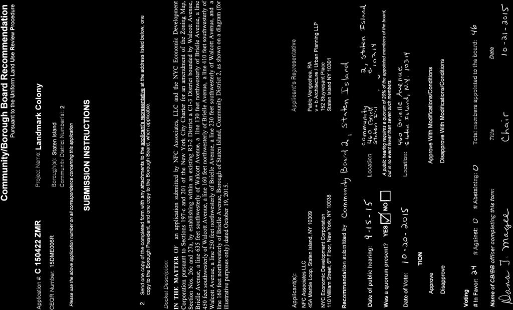
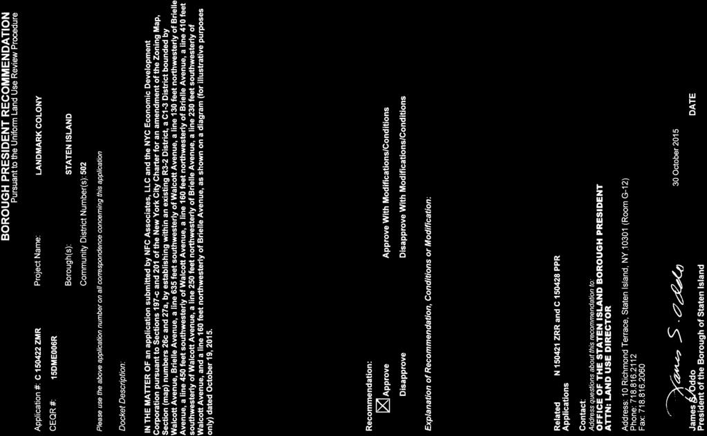
18 Community Board Public Hearing Community Board 2 held a public hearing on this application (C ZMR) and related applications (N ZRR and C PPR) on September 15, 2015, and on October 20, 2015, by a vote of 24 in favor with 0 in opposition and 0 abstentions, adopted a resolution recommending approval of this application. Borough President Recommendation This application was considered by the Borough President, who issued a recommendation approving the application on October 30, City Planning Commission Public Hearing On November 2, 2015 (Calendar No. 5), the CPC scheduled November 18, 2015, for a public hearing on this application (C ZMR), in conjunction with the related applications (N ZRR, N ZAR, N ZAR, N ZAR, N ZAR, N ZCR, C PPR). The hearing was duly held on November 18, 2015 (Calendar No. 17). There were four speakers in favor and none in opposition. The applicant team was represented by the developer and his advisors, including a real estate consultant, design architects, and landscape architects. Two members of the team spoke, including the developer and a design architect. In addition, favorable testimony was provided by EDC and the New York City Housing Preservation and Development (HPD). The applicant spoke in favor of the application, stating that this development would bring much needed housing for the growing senior population of Staten Island. The applicant s architect also spoke in favor of the application, explaining the historic significance of the site and the plan to 18 C ZMR
19 preserve and reuse landmarked buildings, along with site-specific planning and landscape design and new building design. A representative of EDC also spoke in favor of the plan, stating this is the fourth attempt to activate this site by the City, which includes over $100 million in private investment into the project by the developer. A representative of HPD also spoke in favor of the plan, explaining the efforts involved in establishing the ten percent affordable housing agreement for this project. There were no other speakers and the hearing was closed. WATERFRONT REVITALIZATION PROGRAM CONSISTENCY REVIEW The application (C ZMR), in conjunction with the related applications (N ZRR, N ZAR, N ZAR, N ZAR, N ZAR, N ZCR, C PPR), was reviewed by the Department of City Planning for consistency with the policies of the New York City Waterfront Revitalization Program (WRP), as amended, approved by the New York City Council on October 13, 1999 and by the New York State Department of State on May 22, 2002, pursuant to the New York State Waterfront Revitalization and Coastal Resource Act of 1981 (New York State Executive Law, Section 910 et seq.). The designated WRP number is The City Planning Commission, acting as the City Coastal Commission, having reviewed the waterfront aspects of this action, finds that the action will not substantially hinder the achievement of any WRP policy and hereby determines that this action is consistent with WRP policies. 19 C ZMR
20 CONSIDERATION The Commission believes that the application for the zoning map amendment (C ZMR), in conjunction with the related applications (N ZRR, N ZAR, N ZAR, N ZAR, N ZAR, N ZCR, C PPR), is appropriate. The Commission notes that the project site is part of the New York City Farm Colony Seaview Hospital Historic District, designated by the LPC in As such, the Commission believes that the requested actions are appropriate to facilitate the disposal and redevelopment of long vacant city-owned land through the preservation and rehabilitation of historic buildings and landmarked property, the provision of housing for the 55 and over population with 10% at affordable rate as well as acres of public open space, while maintaining the goals of the Special Natural Area District. Zoning Map Amendment C ZMR The Commission believes that, by allowing for the development of new neighborhood retail, the proposed C1-3 overlay district would provide a convenience and benefit to the residents of the proposed development as well as the surrounding community, which is comprised primarily of R3-1, R3-2, and R3X residential districts and is currently commercially underserved. The Commission notes that the retail use on the development site would be fenced off from the residential use to prevent non-residents from parking on residents parking spaces and access to the retail space would be provided to on-site residents via pedestrian gates. Zoning Text Amendment N ZRR 20 C ZMR
21 The Commission believes that the proposed zoning text amendment, which would establish appropriate regulations for modifications to the requirements for driveways and private roads on Tier I sites is appropriate and has findings that would maintain the character of the area while offering similar relief that is currently available to Tier II sites. These findings include, but are not limited to, greater environmental conservation or preservation of existing natural features; superior site and landscape plan that will not unduly disturb the drainage pattern and soil conditions of the area; greater preservation of historic buildings or other architectural elements of the Historic District; and is the least required to achieve the purpose for which the modification is granted. The Commission recognizes that the project site is located within the Special Natural Are District (NA-1), which may require modifications to underlying zoning regulations such as lot coverage controls and yard, height, setback and parking regulations for the purpose of preserving natural features. The Commission also notes that the project site is located within the Lower Density Growth Management Area (LDGMA) as well, which regulates future development to match the capacity of supporting services and infrastructure through perimeter wall height limitations, floor area exemptions for parking spaces within buildings, and required parking and private road standards. The Commission notes that that the private road network will be publicly accessible from dawn to dusk to provide a connection through the site to adjacent streets as well as to the proposed development and the publicly accessible open space. Disposition of City-owned Property C PPR The Commission believes that application for the disposition of City-owned property, in conjunction with the related applications, is appropriate. The project site would be disposed by 21 C ZMR
22 DCAS to LDC, for subsequent disposition and sale to the developer through EDC. The subject property is mostly vacant and densely overgrown with trees and undergrowth, and includes 11 historic buildings and several structures, which are damaged and decayed from vandalism and neglect. The Commission believes that the proposed project facilitated by the requested actions complements the area s existing built context and scale, which are lower-density districts. The site plan associated with the SNAD authorizations, which includes a private road network that would be open to public vehicular and pedestrian traffic from dawn to dusk, would create new connections from Forest Hill Road to Brielle Avenue through the project site, new public access to open space/park features and improved linkages to existing City parks such as, the Staten Island Greenbelt, and new neighborhood retail and community facility space in a relatively underserved area. It would also provide much needed senior housing in Staten Island a borough whose aging population increase is the most pronounced of all boroughs of New York City. Moreover, the proposed project would provide for the adaptive reuse and stabilization of landmarked buildings of the New York City Farm Colony to help preserve the architectural and historic legacy of the site. The Commission, therefore, believes that this application for a map amendment, in conjunction with related applications, is appropriate. RESOLUTION RESOLVED, that having considered the Environmental Assessment Statement (EAS), for which a Revised Negative Declaration was issued on November 16, 2015 superseding a Negative Declaration issued on October 15, 2015, with respect to this application (CEQR No. 22 C ZMR
23 15DME006R), the City Planning Commission finds that the action described herein will have no significant impact on the environment; and be it further RESOLVED, that the City Planning Commission, in its capacity as the City Coastal Commission, has reviewed the waterfront aspects of this application and finds that the proposed action is consistent with WRP policies; and be it further RESOLVED, by the City Planning Commission, pursuant to Sections 200 of the New York City Charter that based on the environmental determination and the consideration described in this report, the Zoning Resolution of the City of New York, effective as of December 15, 1961, and as subsequently amended, is hereby amended by changing the Zoning Map, Section Nos. 26c and 27a, by establishing within an existing R3-2 District a C1-3 District bounded by Walcott Avenue, Brielle Avenue, a line 635 feet southwesterly of Walcott Avenue, a line 130 feet northwesterly of Brielle Avenue, a line 450 feet southwesterly of Walcott Avenue, a line 160 feet northwesterly of Brielle Avenue, a line 410 feet southwesterly of Walcott Avenue, a line 250 feet northwesterly of Brielle Avenue, a line 230 feet southwesterly of Walcott Avenue, and a line 160 feet northwesterly of Brielle Avenue, as shown on a diagram (for illustrative purposes only) dated October 19, The above resolution (C ZMR), duly adopted by the City Planning Commission on December 16, 2015 (Calendar No. 13), is filed with the Office of the Speaker, City Council, and the Borough President, in accordance with the requirements of Section 197-d of the New York City Charter. 23 C ZMR
24 CARL WEISBROD Chair KENNETH J. KNUCKLES, ESQ., Vice Chairman RAYANN BESSER, IRWIN G. CANTOR, P.E., ALFRED C. CERULLO, III, MICHELLE R. DE LA UZ, JOSEPH I. DOUEK, RICHARD W. EADDY, CHERYL COHEN EFFRON, LARISA ORTIZ, ANNA HAYES LEVIN, ORLANDO MARIN, Commissioners 24 C ZMR
25

26
27
28 Exhibit A DECLARATION OF RESTRICTIONS THIS DECLARATION, made as of the day of, 201 by NFC Associates, LLC, a New York limited liability company, having an address at 45A Marble Loop, Staten Island, New York, ( Declarant ). W I T N E S S E T H: WHEREAS, The City of New York, a municipal corporation of the State of New York ( City ), having an address at City Hall, New York, NY 10007,is the fee owner of certain real property, which real property is located in the Borough of Staten Island, County of Richmond, City and State of New York, designated for real property tax purposes as Block 1955, part of Lot 1 (tentative lot numbers 225 and 375) on the Tax Map for the Borough of Staten Island; and WHEREAS, Declarant is the contract-vendee of certain real property under that certain contract of sale made as of the 24 th day of September 2013 ( Developer Contract ) between the City and Declarant, which real property is located in the Borough of Staten Island, County of Richmond, City and State of New York, designated for real property tax purposes as Block 1955, part of Lot 1 (tentative lot numbers 225 and 375) on the Tax Map for the Borough of Staten Island as more particularly described in Exhibit A annexed hereto and made a part hereof ( Subject Property ); and WHEREAS, has certified in a certification annexed hereto as Exhibit B and made a part hereof, that as of, the parties listed on such Exhibit are the only Part(ies) in Interest to the Subject Property, as Part(ies) in Interest is defined in subdivision (c) of the definition of zoning lot in Sec of the Zoning Resolution; and WHEREAS, Declarant desires to improve the Subject Property with a 344-unit agerestricted homeownership residential development containing commercial and community facility uses within the New York City Farm Colony-Seaview Hospital Historic District, designated by the New York City Landmarks Preservation Commission in 1985 ( Landmark Colony ); and WHEREAS, to facilitate the development of Landmark Colony, Declarant filed an application with the New York City Department of City Planning (hereinafter, City Planning )
29 for (1) a zoning map change for establishing within the existing R3-2 zoning district a C1-3 district along a portion of the Subject Property, fronting Brielle Avenue (ULURP No. C ZMR); (2) a zoning text amendment to the Zoning Resolution of the City of New York ( Zoning Resolution or ZR ) changing Section (Authorizations to Modify Bulk, Parking, Grading and Private Roads Regulations) to allow modifications of private roads regulations on a Tier I site; Section (Modification of requirements for private roads and driveways), to allow modifications of Section (SPECIAL REQUIREMENTS FOR DEVELOPMENTS WITH PRIVATE ROADS) and Section (SPECIAL REQUIREMENTS FOR DEVELOPMENTS WITH PRIVATE ROADS IN LOWER DENSITY GROWTH MANAGEMENT AREAS) within the Special Natural Area District (Application No. N ZRR); (3) zoning authorizations (the SNAD Authorizations ) pursuant to Section (Modification of topographic features on Tier I sites) to accommodate roadways, site infrastructure, drainage and cut and fill 15 beyond proposed buildings; to Section (Modification of botanic environment and tree preservation and planting requirements) to facilitate the development of an appropriate landscape plan and the removal of invasive tree species 15 beyond proposed buildings; to Section (Modification of yard, height and setback regulations, and parking location regulations) to allow buildings taller than 35 and front yards less than 15 and required rear yard equivalent less than 60 ; and to Section (Modification of requirements for private roads and driveways) to allow curb cuts greater than 18, including splays and the paved width of a private road to be less than 38 (Application Nos. N ZAR, N ZAR, N ZAR and N ZAR, respectively); and (4) a zoning certification pursuant to ZR Sec (Future Subdivision) to subdivide the existing zoning lot into two zoning lots (Application No. N ZCR); and WHEREAS, the City, through its Department of Citywide Administrative Services ( DCAS ), filed an application with City Planning for the disposition of City-owned property (ULURP No. C PPR) ; (the Disposition Application, collectively with items (1) through (4) in the previous recital, Land Use Applications ), which applications were approved by CPC on, 201, and items (1) and (2) above, along with the Disposition Application, were approved by the New York City Council on, 201 (respectively, the Rezoning and Text Amendment Approval and the Disposition Approval ); and WHEREAS, in connection with the Land Use Applications, Declarant submitted an Environmental Assessment Statement, dated October 15, 2015 and designated CEQR 2
30 No.15DME006R, for review by the Mayor s Office of Sustainability, as lead agency, pursuant to the State Environmental Quality Review Act ("SEQRA") and the City Environmental Quality Review ( CEQR ) (the CEQR Application ); and WHEREAS, in conjunction with the review of the CEQR Application, the lead agency issued a Revised Negative Declaration dated November 16, 2015, superseding the Negative Declaration issued October 15, 2015, that is premised upon the analysis of 344 dwelling units, as set forth in the Environmental Assessment Statement s reasonable worst case development scenario; and WHEREAS, the Disposition Approval requires, as a condition of its exercise, the execution and recordation in the Office of the Richmond County Clerk ( County Clerk ) of a restrictive Declaration acceptable to the New York City Planning Commission ( CPC ), binding the Declarant and its successors and assigns; and WHEREAS, this Declaration sets forth the maximum number of dwelling units (344) analyzed in the CEQR Application, limits development of additional dwelling units, rooming units or combinations thereof, pending further review, and ensures the provision of publicly accessible open space and public vehicular and pedestrian access to the private road network as proposed in the Land Use Applications; and WHEREAS, Declarant desires to restrict the manner in which the Subject Property is developed in the future, and intends these restrictions to benefit all the land, including land owned by the City, lying within a one-half-mile radius of the Subject Property; and WHEREAS, the Declarant intends this Declaration to be binding upon all successors and assigns; NOW, THEREFORE, Declarant hereby declares, covenants and agrees that the Subject Property shall be held, sold, transferred and conveyed subject to the restrictions and obligations herein which shall run with the land, binding the successors and assigns of Declarant so long as they have any right, title or interest in the Subject Property or any part thereof, as follows: 1. Development of Subject Property. Declarant covenants that no more than 344 dwelling units or rooming units, or combination thereof, as such terms are defined in the Zoning 3
31 Resolution, or combination thereof, shall be developed, constructed, operated or maintained on the Subject Property. No dwelling units or rooming units or combination thereof (hereinafter, Living Units ) in excess of 344 shall be permitted unless Declarant has submitted an application for a modification to this Declaration in accordance with the provisions of Section 6 of this Declaration, and such application has been approved. Declarant further covenants that it shall neither apply for nor accept building permits or temporary or final certificates of occupancy for more than the number of Living Units set forth herein, unless an application for a modification to this Declaration in accordance with Section 6 hereof has been approved. 2. Representation. Declarant represents and warrants that there is no restriction of record on the development, enlargement, or use of the Subject Property, nor any present or presently existing estate or interest in the Subject Property, nor any existing lien, obligation, covenant, easement, limitation or encumbrance of any kind that shall preclude the restriction and obligation to develop the Subject Property in accordance with the Approvals and as set forth herein. 3. Binding Effect. The restrictions, covenants, rights and agreements set forth in this Declaration shall be binding upon Declarant and any successor or assign of Declarant as of the Effective Date as set forth in Section 5; provided, that the Declaration shall be binding on any Declarant, only for the period during which such Declarant, or any successor or assign thereof, is the holder of an interest in the Subject Property, and only to the extent of such Declarant s interest in the Subject Property. At such time as a Declarant or any successor to a Declarant no longer holds an interest in the Subject Property, such Declarant s or such Declarant s successor s obligations and liability under this Declaration shall wholly cease and terminate, and the party succeeding such Declarant or such Declarant s successor shall assume the obligations and liability of Declarant pursuant to this Declaration with respect to actions or matters occurring subsequent to the date such party assumes an interest in the Subject Property to the extent of such party s interest in the Subject Property. For purposes of this Declaration, any successor to a Declarant shall be deemed a Declarant for such time as such successor holds all or any portion of any interest in the Subject Property. Reference in this Declaration to agencies or instrumentalities of the City shall be deemed to include agencies or instrumentalities succeeding to jurisdiction thereof pursuant to the laws of the State of New York and the New York City Charter. 4
CITY PLANNING COMMISSION December 16, 2015/Calendar No. 19
 CITY PLANNING COMMISSION December 16, 2015/Calendar No. 19 C 150428 PPR IN THE MATTER OF an application submitted by the Department of Citywide Administrative Services (DCAS), pursuant to Section 197-c
CITY PLANNING COMMISSION December 16, 2009/Calendar No. 8
 CITY PLANNING COMMISSION December 16, 2009/Calendar No. 8 C 090397 ZMX IN THE MATTER OF an application submitted by Webster Commons, LLC pursuant to Sections 197-c and 201 of the New York City Charter
CITY PLANNING COMMISSION October 27, 2010 / Calendar No. 13
 CITY PLANNING COMMISSION October 27, 2010 / Calendar No. 13 N 100294(A) ZRM IN THE MATTER OF an application submitted by CRP/Extell Parcel L, LP and CRP/Extell Parcel N, LP pursuant to Sections 197-c and
February 5, 2014 / Calendar No. 5
 CITY PLANNING COMMISSION February 5, 2014 / Calendar No. 5 C 120178 ZMQ IN THE MATTER OF an application submitted by Zirk Union Tpke, LLC pursuant to Sections 197-c and 200 of the New York City Charter
November 17, 2004/Calendar No. 22
 CITY PLANNING COMMISSION November 17, 2004/Calendar No. 22 C 040495 ZSM IN THE MATTER OF an application submitted by 400 Park Avenue South LLC pursuant to Sections 197-c and 201 of the New York City Charter
CITY PLANNING COMMISSION January 23, 2012 / Calendar No. 2
 CITY PLANNING COMMISSION January 23, 2012 / Calendar No. 2 C 120030 ZSM IN THE MATTER OF an application submitted by RSV, LLC and Saint Vincents Catholic Medical Centers of New York pursuant to Sections
The application for the special permit was filed by 70th Street Holdings, LLC on November 4,
 CITY PLANNING COMMISSION October 12, 2010 / Calendar No. 3 C 100140 ZSM IN THE MATTER OF an application submitted by 70th Street Holdings, LLC, pursuant to Sections 197-c and 201 of the New York City Charter
June 22, 2005/Calendar No. 14
 CITY PLANNING COMMISSION June 22, 2005/Calendar No. 14 C 050400 ZMQ IN THE MATTER OF an application submitted by the Department of City Planning pursuant to Sections 197-c and 201 of the New York City
April 25, 2012/Calendar No. 8
 CITY PLANNING COMMISSION April 25, 2012/Calendar No. 8 IN THE MATTER OF an application submitted by Laight Street Project Owner, LLC pursuant to Section 201 of the New York City Charter, for an amendment
CITY PLANNING COMMISSION January 27, 2010 / Calendar No. 8. 1) pursuant to Article 16 of the General Municipal Law of New York State for:
 pursuant to Article 16 of the General Municipal Law of New York State for:") CITY PLANNING COMMISSION January 27, 2010 / Calendar No. 8 C 100055 HAM IN THE MATTER OF an application submitted by the Department of Housing Preservation and Development (HPD): 1) pursuant to Article
CITY PLANNING COMMISSION January 27, 2010 / Calendar No. 8 C 100055 HAM IN THE MATTER OF an application submitted by the Department of Housing Preservation and Development (HPD): 1) pursuant to Article
IN THE MATTER OF an application submitted by the Department of Housing Preservation and Development (HPD):
:") CITY PLANNING COMMISSION January 7, 2004/Calendar No. 21 C 040029 HAX IN THE MATTER OF an application submitted by the Department of Housing Preservation and Development (HPD): 1) pursuant to Article 16
CITY PLANNING COMMISSION January 7, 2004/Calendar No. 21 C 040029 HAX IN THE MATTER OF an application submitted by the Department of Housing Preservation and Development (HPD): 1) pursuant to Article 16
IN THE MATTER OF an application submitted by the Department of Housing Preservation and Development (HPD):
:") CITY PLANNING COMMISSION April 27, 2005/Calendar No. 12 IN THE MATTER OF an application submitted by the Department of Housing Preservation and Development (HPD): 1) pursuant to Article 16 of the General
CITY PLANNING COMMISSION April 27, 2005/Calendar No. 12 IN THE MATTER OF an application submitted by the Department of Housing Preservation and Development (HPD): 1) pursuant to Article 16 of the General
Air Rights Reference Guide
 Air Rights Reference Guide Revision Date August 15, 2016 City Center Real Estate Inc. 1010 Fifth Avenue New York, NY 10028 ROBERT I. SHAPIRO Founder (212) 396-9705 ris@citycenternyc.com RONALD NOVITA Executive
IN THE MATTER OF an application submitted by the Department of Housing Preservation and Development (HPD):
:") CITY PLANNING COMMISSION May 25, 2005/Calendar No. 19 C 050232 HAM IN THE MATTER OF an application submitted by the Department of Housing Preservation and Development (HPD): 1) pursuant to Article 16 of
CITY PLANNING COMMISSION May 25, 2005/Calendar No. 19 C 050232 HAM IN THE MATTER OF an application submitted by the Department of Housing Preservation and Development (HPD): 1) pursuant to Article 16 of
IN THE MATTER OF an application submitted by the Department of Housing Preservation and Development (HPD):
:") CITY PLANNING COMMISSION July 27, 2005/Calendar No. 13 C 050383 HAK IN THE MATTER OF an application submitted by the Department of Housing Preservation and Development (HPD): 1. pursuant to Article 16
CITY PLANNING COMMISSION July 27, 2005/Calendar No. 13 C 050383 HAK IN THE MATTER OF an application submitted by the Department of Housing Preservation and Development (HPD): 1. pursuant to Article 16
IN THE MATTER OF an application submitted by the Department of Housing Preservation and Development (HPD):
:") CITY PLANNING COMMISSION September 28, 2005/Calendar No. 7 C 050503 HAK IN THE MATTER OF an application submitted by the Department of Housing Preservation and Development (HPD): 1. pursuant to Article
CITY PLANNING COMMISSION September 28, 2005/Calendar No. 7 C 050503 HAK IN THE MATTER OF an application submitted by the Department of Housing Preservation and Development (HPD): 1. pursuant to Article
IN THE MATTER OF an application submitted by the Department of Housing Preservation and Development (HPD):
:") CITY PLANNING COMMISSION June 9, 2004/Calendar No. 20 C 040203 HAK IN THE MATTER OF an application submitted by the Department of Housing Preservation and Development (HPD): 1. pursuant to Article 16 of
CITY PLANNING COMMISSION June 9, 2004/Calendar No. 20 C 040203 HAK IN THE MATTER OF an application submitted by the Department of Housing Preservation and Development (HPD): 1. pursuant to Article 16 of
2003 pursuant to Section of the Zoning Resolution to permit portions of a railroad right-ofway
 CITY PLANNING COMMISSION May 12, 2004 / Calendar No. 24 C 040116 ZSM IN THE MATTER OF an application submitted by West 47 th Street Associates, LLC, pursuant to Sections 197-c and 201 of the New York City
IN THE MATTER OF an application submitted by the Department of Housing Preservation and Development (HPD) :
 :") CITY PLANNING COMMISSION January 28, 2004 Calendar No. 8 C 040060 HAX IN THE MATTER OF an application submitted by the Department of Housing Preservation and Development (HPD) : 1) pursuant to Article
CITY PLANNING COMMISSION January 28, 2004 Calendar No. 8 C 040060 HAX IN THE MATTER OF an application submitted by the Department of Housing Preservation and Development (HPD) : 1) pursuant to Article
CITY PLANNING COMMISSION. February 22, 2017 / Calendar No. 15
 CITY PLANNING COMMISSION February 22, 2017 / Calendar No. 15 N 160396 ZRM IN THE MATTER OF an application submitted by 23rd and 11th Associates, L.L.C. pursuant to Section 201 of the New York City Charter,
East Harlem Rezoning Proposal - Approved!
 This page is located on the NYC.gov Web site at http://www.nyc.gov/html/dcp/html/eastharlem/eastharlem1.shtml Projects & Proposals > Manhattan > East Harlem East Harlem Rezoning Proposal - Approved! REZONING
GWINNETT COUNTY CSO CONSERVATION SUBDIVISION OVERLAY DISTRICT REQUIREMENTS
 GWINNETT COUNTY CSO CONSERVATION SUBDIVISION OVERLAY DISTRICT REQUIREMENTS Section 1316. CSO Conservation Subdivision Overlay District. 1. Purposes. The purposes of this overlay district are as follows:
1. eliminating from an existing R3-2 District a C1-2 District bounded by:
 CITY PLANNING COMMISSION September 10, 2003/Calendar No. 14 C 030467 ZMX IN THE MATTER OF an application submitted by the Department of City Planning pursuant to Sections 197-c and 201 of the New York
ARTICLE FIVE FINAL DRAFT
 ARTICLE FIVE 021218 FINAL DRAFT Sec. 503.6 Open Space Preservation Option Open Space Preservation Option Open Space Preservation developments may be approved in the AR, R-1, R-2 and R-3 zoning districts,
(a) Commercial uses on Laurel Avenue, abutting the TRO District to the
 Commercial uses on Laurel Avenue, abutting the TRO District to the") 32X Zoning Code 150.36 TRANSITIONAL RESIDENTIAL OVERLAY DISTRICT. (A) Intent and purpose. (1) It is the intent of the Transitional Residential Overlay District (hereinafter referred to as the "TRO District")
32X Zoning Code 150.36 TRANSITIONAL RESIDENTIAL OVERLAY DISTRICT. (A) Intent and purpose. (1) It is the intent of the Transitional Residential Overlay District (hereinafter referred to as the "TRO District")
The application for the special permit was filed by the Brooklyn Renaissance Hotel, LLC and the
 CITY PLANNING COMMISSION July 23, 2003/Calendar No. 29 C 030378 ZSK IN THE MATTER OF an application submitted by the Brooklyn Renaissance Hotel, LLC and the Economic Development Corporation pursuant to
City of Fayetteville, Arkansas Page 1 of 3
 City of Fayetteville, Arkansas 113 West Mountain Street Fayetteville, AR 72701 (479) 575-8323 Legislation Text File #: 2018-0144, Version: 1 ADM 18-6094 (AMEND UDC 164.19/ACCESSORY DWELLING UNITS): AN
DEVELOPMENT DEPARTMENT STAFF REPORT DRESDEN HEIGHTS PHASE II DCI
 DEVELOPMENT DEPARTMENT Meeting Date: January 10, 2019 Item #: PZ2019-393 Project Name: Applicant and Owner: Proposed Development: Requests: STAFF REPORT DRESDEN HEIGHTS PHASE II DCI Dresden Heights Phase
CITY OF BONITA SPRINGS ZONING ORDINANCE NO
 CITY OF BONITA SPRINGS ZONING ORDINANCE NO. 05-11 A ZONING ORDINANCE OF THE CITY OF BONITA SPRINGS, FLORIDA; APPROVING A REQUEST BY ROCKPOINT/RONTO NAPLES, LLC IN REFERENCE TO EAST BONITA ACTIVE ADULT
Flatbush Rezoning and Text Amendments LR Item 3: Description of Proposal
 Project Description The New York City Department of City Planning (DCP), at the request of Community Board 14, elected officials and civic groups, proposes zoning map changes and zoning text amendments
Chapter 17-2 Residential Districts
 Chapter 17-2 Residential Districts 17-2-0100 District Descriptions...2-1 17-2-0200 Allowed Uses...2-2 17-2-0300 Bulk and Density Standards...2-5 17-2-0400 Character Standards...2-18 17-2-0500 Townhouse
Appendix J - Planned Unit Development (PUD)
") Appendix J - Planned Unit Development (PUD) Intent and Purpose The purpose of the PUD is: 1. To provide development that is consistent with the Comprehensive Land Use Plan and promote the goals and objectives
Appendix J - Planned Unit Development (PUD) Intent and Purpose The purpose of the PUD is: 1. To provide development that is consistent with the Comprehensive Land Use Plan and promote the goals and objectives
August 24, 2011/Calendar No. 16
 CITY PLANNING COMMISSION _ August 24, 2011/Calendar No. 16 _ IN THE MATTER OF an application submitted by the Department of City Planning pursuant to Section 201 of the New York City Charter, for an amendment
Bowie Marketplace Residential Detailed Site Plan Statement of Justification January 13, 2017 Revised February 2, 1017
 Bowie Marketplace Residential Detailed Site Plan Statement of Justification January 13, 2017 Revised February 2, 1017 Submitted on behalf of: BE Bowie LLC 5410 Edson Lane, Suite 220 Rockville, MD 20852
NEW YORK METHODIST HOSPITAL STATEMENT OF FACTS IN SUPPORT OF AN APPLICATION FOR A SPECIAL ORDER CALENDAR (SOC). AMENDMENT TO APPROVAL
. AMENDMENT TO APPROVAL") NEW YORK METHODIST HOSPITAL STATEMENT OF FACTS IN SUPPORT OF AN APPLICATION FOR A SPECIAL ORDER CALENDAR (SOC). AMENDMENT TO APPROVAL AFFECTED PREMISES: 505-525 6 th Street (Block 1084, Lots 39, 164, 1001,
NEW YORK METHODIST HOSPITAL STATEMENT OF FACTS IN SUPPORT OF AN APPLICATION FOR A SPECIAL ORDER CALENDAR (SOC). AMENDMENT TO APPROVAL AFFECTED PREMISES: 505-525 6 th Street (Block 1084, Lots 39, 164, 1001,
Town of Cary, North Carolina Rezoning Staff Report 14-REZ-31 Cary Park PDD Amendment (Waterford II) Town Council Meeting January 15, 2015
 Town Council Meeting January 15, 2015") Town of Cary, North Carolina Rezoning Staff Report 14-REZ-31 Cary Park PDD Amendment (Waterford II) Town Council Meeting January 15, 2015 REQUEST To amend the Town of Cary Official Zoning Map by amending
Town of Cary, North Carolina Rezoning Staff Report 14-REZ-31 Cary Park PDD Amendment (Waterford II) Town Council Meeting January 15, 2015 REQUEST To amend the Town of Cary Official Zoning Map by amending
the conditions contained in their respective Orders until January 1, 2025, at the discretion of the Director of Planning, Property and Development.
 Part 4: Use Regulations Temporary Uses and Structures Purpose the conditions contained in their respective Orders until January 1, 2025, at the discretion of the Director of Planning, Property and Development.
CITY OF LABELLE ORDINANCE BROWARD AVE LLC PLANNED UNIT DEVELOPMENT REZONE
 CITY OF LABELLE ORDINANCE 2019-04 BROWARD AVE LLC PLANNED UNIT DEVELOPMENT REZONE AN ORDINANCE OF THE CITY OF LABELLE, FLORIDA, AMENDING THE CITY OF LABELLE ZONING MAP FOR PROPERTY LOCATED SOUTH OF BROWARD
DEVELOPMENT DEPARTMENT STAFF REPORT STAFF REPORT EASTSIDE CHAMBLEE LINK DCI
 DEVELOPMENT DEPARTMENT STAFF REPORT Public Hearing Date: April 12, 2018 Item #: PZ-2018-248 STAFF REPORT EASTSIDE CHAMBLEE LINK DCI Request: Development of Community Compact (DCI), ten concurrent variances,
PINE CANYON PD ZONING REGULATIONS
 Review Notes: Green highlight = blanks to be completed before recording. 1. DEFINITIONS For purposes of the PD Plan and these Zoning Regulations: (1) capitalized terms used but not defined in the PD Plan
CITY PLANNING COMMISSION January 27, 2010 / Calendar No. 4
 CITY PLANNING COMMISSION January 27, 2010 / Calendar No. 4 C 100051 ZMM IN THE MATTER OF an application submitted by the New York City Department of Housing Preservation and Development pursuant to Sections
Napa County Planning Commission Board Agenda Letter
 Agenda Date: 9/20/2017 Agenda Placement: 8C Napa County Planning Commission Board Agenda Letter TO: FROM: Napa County Planning Commission Charlene Gallina for David Morrison - Director Planning, Building
Town of Cary, North Carolina Rezoning Staff Report 12-REZ-27 Morris Branch Town Council Public Hearing January 24, 2013
 Town of Cary, North Carolina Rezoning Staff Report 12-REZ-27 Morris Branch Town Council Public Hearing January 24, 2013 REQUEST To amend the Town of Cary Official Zoning Map to rezone approximately 9.0
Cover Letter with Narrative Statement
 Cover Letter with Narrative Statement March 31, 2017 rev July 27, 2017 RE: Rushton Pointe Residential Planned Unit Development Application for Public Hearing for RPUD Rezone PL2015 000 0306 Mr. Eric Johnson,
CITY PLAN COMMISSION STAFF REPORT
 CITY PLAN COMMISSION STAFF REPORT SUBJECT: Request for a Change of Zoning and Preliminary Development Plan FROM: Mara Perry, Director of Planning & Development MEETING DATE: November 6, 2017 PETITION:
DRAFT FOR PUBLIC HEARING (rev. March, 2016)
") Chapter 200. ZONING Article VI. Conservation/Cluster Subdivisions 200-45. Intent and Purpose These provisions are intended to: A. Guide the future growth and development of the community consistent with
Chapter 200. ZONING Article VI. Conservation/Cluster Subdivisions 200-45. Intent and Purpose These provisions are intended to: A. Guide the future growth and development of the community consistent with
ORANGE BLOSSOM GARDENS PLANNED UNIT DEVELOPMENT PREPARED BY: COASTAL ENGINEERING CONSULTANTS, INC.
 ORANGE BLOSSOM GARDENS A PLANNED UNIT DEVELOPMENT PREPARED BY: COASTAL ENGINEERING CONSULTANTS, INC. REVISED OCTOBER 19, 1992 BY THE COLLIER COUNTY LONG RANGE PLANNING DEPARTMENT REVISED DECEMBER, 2008
Staff Report: Date: Applicant: Property Identification: Acreage of Request: Current Zoning of Requested Area: Requested Action: Attached:
 Staff Report: Completed by Jeff Palmer Director of Planning & Zoning Date: November 7, 2018, Updated November 20, 2018 Applicant: Greg Smith, Oberer Land Developer agent for Ronald Montgomery ET AL Property
Washington County, Minnesota Ordinances
 Washington County, Minnesota Ordinances Ordinance No. 153 Text Amendment to the Washington County Development Code - Chapter One, Section 2 and Chapter Two, Part 1, Part 2, Part 3, of the Development Code
THE PEOPLE OF THE CITY OF LOS ANGELES DO ORDAIN AS FOLLOWS:
 ORDINANCE NO. 185462 An ordinance amending Sections 12.03,12.09 A.3 and 12.22 C.27 of Chapter 1 of the Los Angeles Municipal Code to require greater front and rear yard setbacks, restrict small lot subdivisions
The City of Carlsbad Planning Division A REPORT TO THE PLANNING COMMISSION. Item No. P.C. AGENDA OF: March 16, 2011 Project Planner: Shannon Werneke
 The City of Carlsbad Planning Division A REPORT TO THE PLANNING COMMISSION Item No. 2 Application complete date: January 24, 2011 P.C. AGENDA OF: March 16, 2011 Project Planner: Shannon Werneke Project
Action Recommendation: Budget Impact:
 City of Fayetteville Staff Review Form Garner Stoll Submitted By 2018-0144 Legistar File ID 4/17/2018 City Council Meeting Date - Agenda Item Only N/A for Non-Agenda Item 3/22/2018 Submitted Date Action
Planning Commission Report
 cjly City of Beverly Hills Planning Division 455 N. Rexford Drive Beverly Hills, CA 90210 TEL. (310) 285-1141 FAX. (370) 858-5966 Planning Commission Report Meeting Date: April 28, 2016 Subject: Project
DEVELOPMENT DEPARTMENT STAFF REPORT STAFF REPORT DRESDEN DRIVE TOWNHOMES DCI
 DEVELOPMENT DEPARTMENT STAFF REPORT Meeting Date: September 13, 2018 Item #: PZ2018-319 STAFF REPORT DRESDEN DRIVE TOWNHOMES DCI Request: Project Name: Development of Community Compact (DCI) and six concurrent
CITY PLANNING COMMISSION September 11, 2013, Calendar No. 6
 CITY PLANNING COMMISSION September 11, 2013, Calendar No. 6 C 130376 HAK IN THE MATTER OF an application submitted by The Department of Housing Preservation and Development (HPD) 1) pursuant to Article
WRITTEN DECISION OF THE HAYDEN CITY COUNCIL REGARDING MAPLE GROVE PRELIMINARY SUBDIVISION APPLICATION (SUB-0013) HAYDEN SIGNATURE, LLC
 HAYDEN SIGNATURE, LLC") WRITTEN DECISION OF THE HAYDEN CITY COUNCIL REGARDING MAPLE GROVE PRELIMINARY SUBDIVISION APPLICATION (SUB-0013) HAYDEN SIGNATURE, LLC Application of Hayden Signature, LLC, an Idaho limited liability company,
WRITTEN DECISION OF THE HAYDEN CITY COUNCIL REGARDING MAPLE GROVE PRELIMINARY SUBDIVISION APPLICATION (SUB-0013) HAYDEN SIGNATURE, LLC Application of Hayden Signature, LLC, an Idaho limited liability company,
E L M E R B O R O U G H L A N D U S E B O A R D APPLICATION COVER SHEET (to be completed for all applications and appeals)
") E L M E R B O R O U G H L A N D U S E B O A R D APPLICATION COVER SHEET (to be completed for all applications and appeals) 1. Name(s): 2. Address: 3. Telephone Number(s): 4. E-mail: 5. Owner Name(s) (if
E L M E R B O R O U G H L A N D U S E B O A R D APPLICATION COVER SHEET (to be completed for all applications and appeals) 1. Name(s): 2. Address: 3. Telephone Number(s): 4. E-mail: 5. Owner Name(s) (if
CITY PLANNING COMMISSION. July 1, 2009, Calendar No. 19
 CITY PLANNING COMMISSION July 1, 2009, Calendar No. 19 C 080088 ZSM IN THE MATTER OF an application submitted by 111 8th Avenue Parking LLC pursuant to Sections 197-c and 201 of the New York City Charter
ORDINANCE NO (As Amended)
") ORDINANCE NO. 01-2015 (As Amended) To Amend the Official Zoning Map of the City of Worthington, Ohio, to Change Zoning of Certain Land from the C-3 District (Institutions and Office), AR-4.5 District (Low
ORDINANCE NO. 01-2015 (As Amended) To Amend the Official Zoning Map of the City of Worthington, Ohio, to Change Zoning of Certain Land from the C-3 District (Institutions and Office), AR-4.5 District (Low
CHAPTER34 PRUD - PLANNED RESIDENTIAL UNIT DEVELOPMENT
 CHAPTER34 PRUD - PLANNED RESIDENTIAL UNIT DEVELOPMENT 17-34-1 17-34-2 17-34-3 17-34-4 17-34-5 17-34-6 17-34-7 17-34-8 17-34-9 Purpose Planned Residential Unit Development Defined Planned Residential Unit
CHARTER TOWNSHIP OF CALEDONIA COUNTY OF KENT, MICHIGAN. at the Township and Village Hall, 8196 Broadmoor Avenue, Caledonia, Michigan on the
 First Reading CHARTER TOWNSHIP OF CALEDONIA COUNTY OF KENT, MICHIGAN At a regular meeting of the Township Board of the Charter Township of Caledonia, held at the Township and Village Hall, 8196 Broadmoor
AN ORDINANCE AMENDING THE CITY ZONING ORDINANCE AND THE OFFICIAL CODE OF THE CITY OF CLARKSVILLE RELATIVE TO CLUSTER OPTION DEVELOPMENTS
 ORDINANCE 74-2012-13 AN ORDINANCE AMENDING THE CITY ZONING ORDINANCE AND THE OFFICIAL CODE OF THE CITY OF CLARKSVILLE RELATIVE TO CLUSTER OPTION DEVELOPMENTS BE IT ORDAINED BY THE CITY COUNCIL OF THE CITY
ARTICLE 15. RULES, REGULATIONS AND DEFINITIONS
 ARTICLE 15. RULES, REGULATIONS AND DEFINITIONS Section 1. Interpretation and Construction: The following rules and regulations regarding interpretation and construction of the Ulysses-Grant County, Kansas,
Proposed Overland Park Kansas Ordinance RE-1 Residential Estates Community
 18.171 RE-1 Residential Estate Community 18.171.010 Statement of intent. The zoning of property as RE-1, (Residential Estates Community, 1 dwelling unit per Gross acre density), is intended to provide
DEVELOPMENT DEPARTMENT STAFF REPORT THE PARK AT 5 TH
 DEVELOPMENT DEPARTMENT STAFF REPORT ARB Meeting Date: July 3, 2018 Item #: _PZ2018-293_ THE PARK AT 5 TH Request: Site Address: Project Name: Parcel Number: Applicant: Proposed Development: Current Zoning:
R E S O L U T I O N. 2. Development Data Summary:
 R E S O L U T I O N WHEREAS, the Prince George s County Planning Board has reviewed Special Permit Application No. SP-170001, Mama s Care Assisted Living Facility, requesting to expand an existing congregate
VILLAGE OF ORLAND PARK
 14700 Ravinia Avenue Orland Park, IL 60462 www.orlandpark.org Ordinance No: File Number: 2016-0865 ORDINANCE REZONING CERTAIN REAL ESTATE FROM E-1 ESTATE RESIDENTIAL DISTRICT TO COR MIXED USE DISTRICT
Condominium Unit Requirements.
 ARTICLE 19 CONDOMINIUM REGULATIONS Section 19.01 Purpose. The purpose of this Article is to regulate projects that divide real property under a contractual arrangement known as a condominium. New and conversion
TOWNSHIP OF UPPER MACUNGIE LEHIGH COUNTY, PENNSYLVANIA. ORDINANCE NO [To be considered for Adoption June 1, 2017]
![TOWNSHIP OF UPPER MACUNGIE LEHIGH COUNTY, PENNSYLVANIA. ORDINANCE NO [To be considered for Adoption June 1, 2017]](/thumbs/91/106428876.jpg "TOWNSHIP OF UPPER MACUNGIE LEHIGH COUNTY, PENNSYLVANIA. ORDINANCE NO [To be considered for Adoption June 1, 2017]") TOWNSHIP OF UPPER MACUNGIE LEHIGH COUNTY, PENNSYLVANIA ORDINANCE NO. 2017 05 [To be considered for Adoption June 1, 2017] AN ORDINANCE OF THE BOARD OF SUPERVISORS OF THE TOWNSHIP OF UPPER MACUNGIE, LEHIGH
TOWNSHIP OF UPPER MACUNGIE LEHIGH COUNTY, PENNSYLVANIA ORDINANCE NO. 2017 05 [To be considered for Adoption June 1, 2017] AN ORDINANCE OF THE BOARD OF SUPERVISORS OF THE TOWNSHIP OF UPPER MACUNGIE, LEHIGH
CITY OF BONITA SPRINGS ZONING ORDINANCE NO
 CITY OF BONITA SPRINGS ZONING ORDINANCE NO. 07-17 A ZONING ORDINANCE OF THE CITY OF BONITA SPRINGS, FLORIDA; APPROVING A REQUEST BY MR. JAMES INK IN REFERENCE TO DORSET HARBOR TO REZONE FROM AGRICULTURAL
Staff Report: Date: Applicant: Property Identification: Acreage of Request: Current Zoning of Requested Area: Requested Action: Attached:
 Staff Report: Completed by Jeff Palmer Director of Planning & Zoning Date: November 7, 2018 Applicant: Greg Smith, Oberer Land Developer agent for Ronald Montgomery ET AL Property Identification: Frontage
ARTICLE C. ZONING TEXT, DISTRICT CLASSIFICATIONS AND BOUNDARIES
 ARTICLE C. ZONING TEXT, DISTRICT CLASSIFICATIONS AND BOUNDARIES Sec. 10-2054. ZONING TEXT, DISTRICT CLASSIFICATIONS AND BOUNDARIES. In order to regulate the location of structures, the height and bulk
A favorable recommendation to the City Council is requested.
 To: Sycamore Plan Commission From: Brian Gregory, City Manager Date: November 9, 2017 Re: November 13, 2017 Plan Commission Meeting The Plan Commission has one action item and three workshop items. I.
Staff Report PLANNED DEVELOPMENT. Salt Lake City Planning Commission. From: Lauren Parisi, Associate Planner; Date: December 14, 2016
 Staff Report PLANNING DIVISION COMMUNITY & NEIGHBORHOODS To: Salt Lake City Planning Commission From: Lauren Parisi, Associate Planner; 801-535-7932 Date: December 14, 2016 Re: 1611 South 1600 East PLANNED
SITE PLAN REVIEW PROCEDURES SECTION DEVELOPMENTS REQUIRING SITE PLAN APPROVAL
 SECTION 22.01 PURPOSE ARTICLE XXII PROCEDURES The purpose of this Article is to establish uniform requirements of procedure for all developments in the Township. Certain specific types of minor development
Exhibit "A" have applied for a re-zoning and re-classification of that property from OPEN RURAL (OR) to that of a PLANNED UNIT DEVELOPMENT (PUD); and
 to that of a PLANNED UNIT DEVELOPMENT (PUD); and") I NSTR # 200632845 OR BK 61439 PGS 0728-0750 RECORDED 06/24/2066 12:25:50 PR JOHN Q. CRAWFOKD CLERK OF CIRCUIT COURT NASSAU COUNTY, FLORIDA RECORDING FEES 1.37.80 ORDINANCE NO. 2006-65 AN ORDINANCE AMENDING
I NSTR # 200632845 OR BK 61439 PGS 0728-0750 RECORDED 06/24/2066 12:25:50 PR JOHN Q. CRAWFOKD CLERK OF CIRCUIT COURT NASSAU COUNTY, FLORIDA RECORDING FEES 1.37.80 ORDINANCE NO. 2006-65 AN ORDINANCE AMENDING
Residential Project Convenience Facilities
 Standards for Specific Land Uses 35.42.220 E. Findings. The review authority shall approve a Land Use Permit in compliance with Subsection 35.82.110.E (Findings required for approval) or a Conditional
4 June 11, 2014 Public Hearing
 4 June 11, 2014 Public Hearing APPLICANT: FRANKLIN JOHNSTON MANAGEMENT DEVELOPMENT, L.L.C. PROPERTY OWNER: TRUSTEES OF FIRST LYNNHAVEN BAPTIST CHURCH STAFF PLANNER: Stephen J. White REQUEST: Change of
Community Development
 Land Use Petition RZ-16-002 Date of Staff Recommendation Preparation: April 15, 2016 (CEL) Date of Planning Commission Recommendation: May 3, 2016 PROJECT LOCATION: DISTRICT/SECTION/LANDLOT(S): ACREAGE
CITY OF SARATOGA SPRINGS ZONING ORDINANCE
 Appendix C: 8. The Village At Saratoga Planned Unit Development (formerly 241.8) Chapter 241.8 AN ORDINANCE PROVIDING FOR THE ESTABLISHMENT OF A PLANNED UNIT DEVELOPMENT DISTRICT TO BE KNOWN AS "THE VILLAGE
Town of Cary, North Carolina Rezoning Staff Report 14-REZ-20 Habitat for Humanity Evans Road Town Council Meeting October 16, 2014
 Town of Cary, North Carolina Rezoning Staff Report 14-REZ-20 Habitat for Humanity Evans Road Town Council Meeting October 16, 2014 REQUEST To amend the Town of Cary Official Zoning Map by rezoning 0.53
CITY OF EAU CLAIRE, WISCONSIN. SPECIAL ASSESSMENT POLICY (Dated: November 8, 2016)
") CITY OF EAU CLAIRE, WISCONSIN SPECIAL ASSESSMENT POLICY (Dated: November 8, 2016) (Adopted by reference by Ordinance No. 7207 adopted November 8, 2016) PURPOSE The purpose of this Policy is to assure fair
CITY OF EAU CLAIRE, WISCONSIN SPECIAL ASSESSMENT POLICY (Dated: November 8, 2016) (Adopted by reference by Ordinance No. 7207 adopted November 8, 2016) PURPOSE The purpose of this Policy is to assure fair
FINAL DRAFT 12/1/16, Rev. to 7/18/17
 FINAL DRAFT 12/1/16, Rev. to 7/18/17 (As Adopted 8/8/17 Effective 9/1/17) SHELTON PLANNING AND ZONING COMMISSION Proposed Amendments to Zoning Regulations I. Amend Section 23 PERMITTED USES by inserting
Operating Standards Attachment to Development Application
 Planning & Development Services 2255 W Berry Ave. Littleton, CO 80120 Phone: 303-795-3748 Mon-Fri: 8am-5pm www.littletongov.org Operating Standards Attachment to Development Application 1 PLANNED DEVELOPMENT
Subdivision, Development Plan and PUD Design Standards Porter County Unified Development Ordinance
 Chapter Subdivision, Development Plan and PUD Design Standards Porter County Unified Development Ordinance 20 Bradley E. Johnson, AICP website www.groundrulesinc.com Design Standards Section Name Page
O-I (Office-Institutional) and AG-1(Agricultural)
 and AG-1(Agricultural)") PROPERTY INFORMATION ADDRESS 3503 and 3505 Bethany Bend DISTRICT, LAND LOTS 2/1 973 and 974 OVERLAY DISTRICT State Route 9 PETITION NUMBERS EXISTING ZONING O-I (Office-Institutional) and AG-1(Agricultural)
PROPERTY INFORMATION ADDRESS 3503 and 3505 Bethany Bend DISTRICT, LAND LOTS 2/1 973 and 974 OVERLAY DISTRICT State Route 9 PETITION NUMBERS EXISTING ZONING O-I (Office-Institutional) and AG-1(Agricultural)
CONDOMINIUM REGULATIONS
 ARTICLE 37 CONDOMINIUM REGULATIONS SECTION 37.01. Purpose The purpose of this Article is to regulate projects that divide real property under a contractual arrangement known as a condominium. New and conversion
CITY OF SIGNAL HILL SUBJECT: PUBLIC HEARING THE COURTYARD RESIDENTIAL DEVELOPMENT OF 10 CONDOMINIUMS AND A NEW SPECIFIC PLAN
 CITY OF SIGNAL HILL 2175 Cherry Avenue Signal Hill, CA 90755-3799 AGENDA ITEM TO: FROM: HONORABLE CHAIR AND MEMBERS OF THE PLANNING COMMISSION SELENA ALANIS ASSOCIATE PLANNER SUBJECT: PUBLIC HEARING THE
SECTION 16. "PUD" PLANNED UNIT DEVELOPMENT OVERLAY DISTRICT
 SECTION 6. "PUD" PLANNED UNIT DEVELOPMENT OVERLAY DISTRICT Subsection. Purpose. This district is established to achieve the coordinated integration of land parcels and large commercial and retail establishments
WESTMINSTER PARK SUBDIVISION
 WESTMINSTER PARK SUBDIVISION Engineering Comments: FINAL PLAT COMMENTS (should be addressed prior to submitting the FINAL PLAT for review and/or signature by the City Engineer): A. Provide all of the required
RC ; Reclassification The Garrison at Stafford Proffer Amendment (formerly Stafford Village Center)
") Board of Supervisors Robert Bob Thomas, Jr., Chairman Laura A. Sellers, Vice Chairman Meg Bohmke Jack R. Cavalier Wendy E. Maurer Paul V. Milde, III Gary F. Snellings Anthony J. Romanello, ICMA CM County
Board of Supervisors Robert Bob Thomas, Jr., Chairman Laura A. Sellers, Vice Chairman Meg Bohmke Jack R. Cavalier Wendy E. Maurer Paul V. Milde, III Gary F. Snellings Anthony J. Romanello, ICMA CM County
ARTICLE 9 SPECIFICATIONS FOR DOCUMENTS TO BE SUBMITTED
 ARTICLE 9 SPECIFICATIONS FOR DOCUMENTS TO BE SUBMITTED SECTION 950 GENERALLY All applications shall be properly signed and filed by the owner or, with the owner s specific written consent, a contract purchaser
PLNSUB Meridian Commerce Center Subdivision Amendment & PLNPCM Meridian Commerce Center Street Closure
 Staff Report PLANNING DIVISION COMMUNITY & ECONOMIC DEVELOPMENT To: From: Salt Lake City Planning Commission Daniel Echeverria, 801-535-7165, daniel.echeverria@slcgov.com Date: September 4, 2014 Re: PLNSUB2014-000469
DRAFT Permanent Supportive Housing Ordinance Page 1 As amended by the City Planning Commission on December 14, 2017 CPC CA ORDINANCE NO.
 DRAFT Permanent Supportive Housing Ordinance Page 1 ORDINANCE NO. An ordinance amending Sections 12.03, 12.04.09, 14.00, and 16.05 of the Los Angeles Municipal Code establishing regulations to facilitate
ATTACHMENT A REQUEST/BACKGROUND INFORMATION VENTURA/TYRONE REDEVELOPMENT PROJECT PROJECT OVERVIEW/REQUEST BACKGROUND Ventura Boulevard
 Revised October 28, 2016 ATTACHMENT A REQUEST/BACKGROUND INFORMATION VENTURA/TYRONE REDEVELOPMENT PROJECT Sherman Oaks, CA 91423 PROJECT OVERVIEW/REQUEST The Applicant, 14311 Ventura Development, LLC,
UPPER MOUNT BETHEL TOWNSHIP NORTHAMPTON COUNTY, PENNSYLVANIA
 UPPER MOUNT BETHEL TOWNSHIP NORTHAMPTON COUNTY, PENNSYLVANIA JOINDER DEED / LOT CONSOLIDATION TOWNSHIP REVIEW PROCESS When accepting proposed Joinder Deeds / Lot Consolidations, review the Joinder Deed
Honorable Mayor and Members of the City Council
 Office of the City Manager ACTION CALENDAR June 11, 2013 To: From: Honorable Mayor and Members of the City Council Christine Daniel, City Manager Submitted by: Eric Angstadt, Director, Planning & Development
1. APPLICANT: The City of Overland Park is the applicant for this request.
 8. UNIFIED DEVELOPMENT ORDINANCE AMENDMENT - ZRR 2590 - Residential Neighborhood District 1. APPLICANT: The City of Overland Park is the applicant for this request. 2. REQUESTED ACTION: The applicant is
Charter Township of Garfield Grand Traverse County
 Charter Township of Garfield Grand Traverse County 3848 VETERANS DRIVE TRAVERSE CITY, MICHIGAN 49684 PH: (231) 941-1620 FAX: (231) 941-1588 GUIDE FOR THE SUBMISSION OF AN APPLICATION FOR SITE PLAN REVIEW
A. Preserve natural resources as identified in the Comprehensive Plan.
 1370.08 Conservation Residential Overlay District. Subd. 1 Findings. The City finds that the lands and resources within the Conservation Residential Overlay District are a unique and valuable resource