LISA ANDERSON-OGILVIE, AICP DEPUTY COMMUNITY DEVELOPMENT DIRECTOR AND PLANNING ADMINISTRATOR
|
|
|
- Karin Sparks
- 5 years ago
- Views:
Transcription
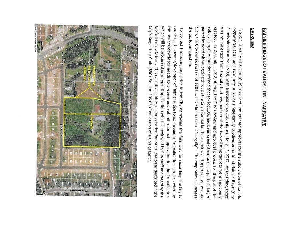
1 FOR MEETING OF: February 13, 2019 CASE NO.: VUL18-04 TO: FROM: HEARINGS OFFICER LISA ANDERSON-OGILVIE, AICP DEPUTY COMMUNITY DEVELOPMENT DIRECTOR AND PLANNING ADMINISTRATOR SUBJECT: VALIDATION OF UNITS OF LAND CASE RAINIER DRIVE SE AMANDA NO LD REQUEST A proposal to validate one land area that was created through a sale by deed in The request is to establish lawfully a land area created in 1985, consisting of tax lots 1201 and 1400 together, which by deed relocated a property line and consolidated the land areas. The sale effectively divided the parent parcel and consolidated several units of land without a land use approval. The applicant is requesting to validate property known as Marion County Tax Assessors number 083W16DB /1201 together with 083W16DB /1400; also known as 197 Rainier Drive SE. The land area is approximately 7.7 acres in size, zoned RA (Residential Agriculture), and located at the 197 Rainier Drive SE (Marion County Assessor Map and Tax Lot Numbers: 083W16DB /1201 together with 083W16DB /1400). OWNER: AGENT: Don James for City Gleanns, LLC Mark Ferris for Project Delivery Group, LLC RECOMMENDATION Based on the application and information presented in the staff report, staff recommends that the Hearings Officer adopt the Facts and Findings of the staff report and APPROVE the request to validate one unit of land that was created through sale rather than through an approved subdivision or partition plat process, for property zoned RA (Residential Agriculture) and located at the 197 Rainier Drive SE. BACKGROUND/PROPOSAL The proposal involves a unit of land, Tax Lot 1201, which was unlawfully created through a deed sale in 1984 (Reel 362, Page 1332) and Tax Lot 1400, when it was consolidated with Tax Lot 1201 in 1985 (Reel 396, Page 184). In 1985, Tax Lots 1201 and 1400 were sold, together, by a sales contract. Because the division and consolidation of the property into a new unit of land did not receive land use approval for a partition or property line adjustment, the individual unit of land as not lawfully established. SRC codifies the Oregon Legislative Assembly House Bill 2723 (2007), which provided authority to Oregon cities and counties to validate units of land that were previously created by sale, but where the resulting land division did not comply with applicable law regulating such divisions.
2 Validation of Unit of Land Case No. VUL18-04 Hearings Officer Meeting of February 13, 2019 Page 2 Tax Lots 1201 and 1400 should not have been sold as a separate unit of land because it is not currently a legal lot. The validation of unit of land process provided in SRC provides a method to correct this error. On December 21, 2018 Project Delivery Group on behalf of the property owner, City Gleanns, LLC, filed a request to validate an existing unit of land that was created through sale rather than through an approved subdivision or partition plat process, for property zoned RA (Residential Agriculture) and located at 197 Rainier Drive SE. The application was deemed complete for processing on December 31, Notice of the public hearing was mailed January 24, Notice was also posted on the subject property by the applicant s representative pursuant to SRC requirements. The state-mandated 120- deadline to issue a final local decision in this case is April 30, APPLICANT S STATEMENT A request for a validation of unit of land must be supported by proof that it conforms to all applicable criteria imposed by the Salem Revised Code. The applicant submitted such statements, which are included in their entirety as Attachment B to this staff report. Staff utilized the information from the applicant s statements to evaluate the applicant s proposal and to compose the facts and findings within the staff report. FACTS AND FINDINGS 1. Salem Area Comprehensive Plan (SACP) Designation Comprehensive Plan Map: The subject property, is designated Residential Agriculture on the Salem Area Comprehensive Plan (SACP) Map. Urban Growth Policies: The subject property is located inside of the Salem Urban Growth Boundary and inside the corporate city limits. Growth Management: The subject property is located outside of the Urban Service Area. 2. Zoning and Surrounding Land Use The subject property is zoned RA (Residential Agriculture). The property subject to the validation request, Tax Lot 1201 and 1400, are currently vacant. The surrounding properties are zoned and used as follows: North: South: East: West: RS (Single Family Residential); Residential Subdivision Across Rainier Drive SE; RS (Single Family Residential); Residential Subdivision RS (Single Family Residential); Residential Subdivision RA (Residential Agriculture); Vacant
3 Validation of Unit of Land Case No. VUL18-04 Hearings Officer Meeting of February 13, 2019 Page 3 3. Existing Site Conditions The subject property (Tax Lot 1201 and 1400 together) is mostly rectangular. Rainer Drive SE, a local street, provides access to the subject property along the south of Mt Rushmore Street SE, a local street, along the east. The subject property has been previously approved for a tentative subdivision to create 35 residential lots. The overall subject property is sloping, varying in elevation from approximately 578 feet in elevation near the northwest corner to approximately 618 feet in elevation at the southeast corner. 4. Neighborhood and Citizen Comments The subject property is located within the boundaries of South Gateway Neighborhood Association (SGNA). Notification was sent to the neighborhood associations and surrounding property owners within 250 feet of the property on January 24, Notice of the proposed application was also posted on the subject property. As of the date of this staff report, no written comments have been received from SGNA. 5. City Department and Public Agency Comments The Public Works Department, Development Services, and City Surveyor staff reviewed the proposal and provided these comments and recommendations for plat approval. 1) Plat Submittal: Require project surveyor to submit his or her Partition Plat to the City Surveyor for review as per ORS (2)(g)&(h), ORS (2)(b), ORS (2), ORS (4), OAR (4)&(10), OAR (2) and OAR (5). 2) Final Plat Application: Provide preliminary plat information to Development Services staff as outlined in the City of Salem Land Surveys and Plats webpage. Once the application has been deemed complete, complete the Final Plat Application. 3) Pre-Plat Review Meeting: Please request a Pre-Plat Review Meeting between the City Surveyor and the applicant's project surveyor to ensure compliance with comments (1) and (2) as described above. 4) ORS and SRC: The application shall provide the required field survey and partition plat as per the statute and code requirements outlined in the Oregon Revised Statues (ORS) and the Salem Revised Code (SRC). If the said documents are not in compliance with the requirements outlined in ORS and SRC, and as per SRC , the approval of the partition plat by the City Surveyor may be delayed or held indefinitely based on the non-compliant violation. The Building and Safety Division reviewed the proposal and identified no apparent issues.
4 Validation of Unit of Land Case No. VUL18-04 Hearings Officer Meeting of February 13, 2019 Page 4 The Salem Fire Department reviewed the proposal and indicated that they have no concerns for this land division. 6. Public Agency and Private Service Provider Comments Public agencies and public and private service providers for the subject property were mailed notification of the proposal. No comments were received at the time the report was prepared. 7. Criteria for Granting a Validation of Unit of Land SRC (d) sets forth the criteria that must be met before a unit of land can be validated. 1 In order to approve a validation of unit of land, the review authority shall make findings based on evidence provided by the applicant demonstrating that all the following criteria and factors are satisfied. The applicable criteria are stated below in bold print. Following each criterion is a response and/or finding relative to the proposed tentative partition. The applicant provided justification for all applicable criteria (Attachment B). SRC (d)(1): The unit of land is not a lawfully established unit of land. Finding: The property was annexed into the City of Salem in February of The land area was under Marion County jurisdiction at the time of creation (1985). The applicant has provided the Marion County Code for the Residential Agriculture (RA) zone. The original parcel of land consisted of Tax Lots 1000, 1100, 1300, 1200, and 1201 separately from Tax Lot The unit of land subject to the validation request was created in 1985, after a previous land division by deed and then ultimately consolidation of Tax Lots 1201 and 1400, together, through a deed recorded selling of the subject property. Therefore, the land area of Tax Lots 1201 and 1400 was not a lawfully established unit of land. This criterion is met. SRC (d)(2): The unit of land was created through sale or deed or land sales contract executed and recorded before January 1, Applicant Statement: It appears that TL 1201 and 1400 were described together first in Finding: Staff concurs with the applicant s written statement. The subject unit of land, which includes Tax Lot 1201 and 1400, together, was not created solely to establish a separate tax account, and was not created by gift or any other method that is not considered a sale. The applicant has provided a copy of the recorded deed (R 396, P184) creating the subject unit of land through sale as evidence that this criterion is met. 1 Notwithstanding criterion SRC (d)(3), the Hearings Officer may approve an application to validate a unit of land that was unlawfully created prior to January 1, 2007, if approval was issued for a permit to allow the construction or placement of a dwelling or other building on the unit of land after the sale. No approval has been issued for such construction on Tax Lot 1200.
5 Validation of Unit of Land Case No. VUL18-04 Hearings Officer Meeting of February 13, 2019 Page 5 SRC (d)(3): The unit of land could have complied with applicable criteria for the creation of the unit of land in effect when the unit of land was sold. Finding: The subject property was entirely zoned RA (Residential Agriculture) under Marion County jurisdiction, when the land area was created by deed. The applicant provided the 1985 Marion County Code Chapter 129, RA Zone, which were in effect when the land area was created. The development standards of the RA zone had a minimum 6,000 square foot lot size, and 60-foot width dimension requirement. The land area has more than 60-feet in width, and more than 6,000 square foot square footage. The Marion County RA Zone in effect when the deed was recorded in 1985 could have allowed the parcel as a lawful parcel through a land use determination decision. This criterion is met. SRC (d)(4): The plat complies with SRC and ORS 92. Finding: The applicant submitted a copy of a proposed plat (Attachment C). The Public Works Department reviewed the proposal and submitted comments describing the procedure and submittal requirements for recording of a final plat. RECOMMENDATION Based on the application and information presented in the staff report, staff recommends that the Hearings Officer adopt the Facts and Findings of the staff report and APPROVE the request to validate one unit of land that was created through sale rather than through an approved subdivision or partition plat process, for property zoned RA (Residential Agriculture) and located at 197 Rainier Drive SE (Marion County Assessor Map and Tax Lot Numbers: 083W16DB /1201 together with 083W16DB /1400). Prepared by Olivia Glantz, Planner III Application Deemed Complete Date: December 31, 2018 State Mandated Decision Date: April 30, 2019 Attachments: A. Vicinity Map B. Applicant s Statement C. Applicant s Proposed Plat G:\CD\PLANNING\CASE APPLICATION Files 2011-On\VALIDATION of UNIT of LAND\2018\Staff Reports\VUL18-04.ocg.docx

6 Vicinity Map 197 Rainier Drive SE ROCK CREEK DR S LIBERTY RD S MINK HOLLOW ST SE ATHENS ST SE HOLDER LN SE CARNELIA ST SE SEEGER LN SE CREEK CROISAN ALESIA CT SE KUEBLER SKYLINE RD DAVIS RD G AVE Inset Map LIBERTY k BLVD MILDRED LN PINTAIL AV SE SUNNYSIDE RD PRINGLE MALLARD ST SE COMMER n CROSSLER MIDDLE SCHOOL SCHOOL HAWK HILL ST SE LANTANA AV SE MIRANDA AV SE ROLLING HILLS AV SE SEEGER LN SE INTEGRA AV SE Subject Property WIGEON ST SE REES HILL RD EIDER AV SE DAVIS RD S CINNAMON TEAL ST SE GADWALL AV SE RAINIER DR SE SUMMIT VIEW AV SE DUNIWAY CT SE MOUNTAIN VISTA AV SE BOX CANYON ST SE HORIZON VIEW ST SE MILDRED LN SE Bryan Johnston Park Legend Taxlots Urban Growth Boundary City Limits Feet Outside Salem City Limits Historic District n Schools Ê Parks Community Development Dept. This product is provided as is, without warranty. In no event is the City of Salem liable for damages from the use of this product. This product is subject to license and copyright limitations and further distribution or resale is prohibited. \\FILESHARE2\CityGIS\CD\Proj\CP\Vicinity_Maps\2017_ARCHIVE\VicinityMapTemplate2017_maj-st-labels2anno.mxd - 9:58:03 AM
7
8
9
10
11
12
13
HEARING NOTICE LAND USE REQUEST AFFECTING THIS AREA
 HEARING NOTICE LAND USE REQUEST AFFECTING THIS AREA Audiencia Pública Si necesita ayuda para comprender esta informacion, por favor llame 503-588-6173 CASE NUMBER: AMANDA APPLICATION NO: HEARING INFORMATION:
LISA ANDERSON-OGILVIE, AICP DEPUTY COMMUNITY DEVELOPMENT DIRECTOR AND PLANNING ADMINISTRATOR
 FOR MEETING OF: January 9, 2019 CASE NO.: VUL18-02 TO: FROM: HEARINGS OFFICER LISA ANDERSON-OGILVIE, AICP DEPUTY COMMUNITY DEVELOPMENT DIRECTOR AND PLANNING ADMINISTRATOR SUBJECT: VALIDATION OF UNITS OF
LISA ANDERSON-OGILVIE, AICP DEPUTY COMMUNITY DEVELOPMENT DIRECTOR AND PLANNING ADMINISTRATOR
 FOR MEETING OF: April 10, 2019 CASE NO.: VUL19-03 TO: FROM: HEARINGS OFFICER LISA ANDERSON-OGILVIE, AICP DEPUTY COMMUNITY DEVELOPMENT DIRECTOR AND PLANNING ADMINISTRATOR SUBJECT: VALIDATION OF UNIT OF
LISA ANDERSON-OGILVIE, AICP DEPUTY COMMUNITY DEVELOPMENT DIRECTOR AND PLANNING ADMINISTRATOR
 FOR MEETNG OF: January 9, 2019 CASE NO.: VUL18-03 TO: FROM: HEARNGS OFFCER LSA ANDERSON-OGLVE, ACP DEPUTY COMMUNTY DEVELOPMENT DRECTOR AND PLANNNG ADMNSTRATOR SUBJECT: VALDATON OF UNT OF LAND CASE 18-03
LISA ANDERSON-OGILVIE, AICP DEPUTY COMMUNITY DEVELOPMENT DIRECTOR AND PLANNING ADMINISTRATOR
 FOR MEETING OF: December 12, 2018 CASE NO.: VUL18-01 TO: FROM: HEARINGS OFFICER LISA ANDERSON-OGILVIE, AICP DEPUTY COMMUNITY DEVELOPMENT DIRECTOR AND PLANNING ADMINISTRATOR SUBJECT: VALIDATION OF UNIT
LISA ANDERSON-OGILVIE, AICP DEPUTY COMMUNITY DEVELOPMENT DIRECTOR AND PLANNING ADMINISTRATOR
 FOR MEETING OF: October 24, 2018 CASE NO.: CU-18-09 TO: FROM: HEARINGS OFFICER LISA ANDERSON-OGILVIE, AICP DEPUTY COMMUNITY DEVELOPMENT DIRECTOR AND PLANNING ADMINISTRATOR SUBJECT: CONDITIONAL USE NO.
HEARING NOTICE LAND USE REQUEST AFFECTING THIS AREA
 HEARING NOTICE LAND USE REQUEST AFFECTING THIS AREA Audiencia Pública Si necesita ayuda para comprender esta informacion, por favor llame 503-588-6173 CASE NUMBER: AMANDA APPLICATION NO: Validation of
Lisa Anderson-Ogilvie, AICP, Interim Community Development Director. APPLICATION: Comprehensive Plan Change / Zone Change Case No.
 FOR MEETING OF: October 3, 2017 AGENDA ITEM NO.: 6.1 TO: FROM: STAFF: Planning Commission Lisa Anderson-Ogilvie, AICP, Interim Community Development Director Olivia Glantz, Planner II HEARING DATE: October
HEARING NOTICE LAND USE REQUEST AFFECTING THIS AREA
 HEARING NOTICE LAND USE REQUEST AFFECTING THIS AREA Audiencia Pública Si necesita ayuda para comprender esta informacion, por favor llame 503-588-6173 CASE NUMBER: AMANDA APPLICATION NO: HEARING INFORMATION:
MINUTES SALEM HEARINGS OFFICER MEETING December 20, 2017
 MINUTES SALEM HEARINGS OFFICER MEETING December 20, 2017 Hearings Officer Jim Brewer Staff Present Pamela Cole, Planner II Bryce Bishop, Planner II Sally Long, Recorder Hearings Officer Jim Brewer called
HEARING NOTICE LAND USE REQUEST AFFECTING THIS AREA
 HEARING NOTICE LAND USE REQUEST AFFECTING THIS AREA Audiencia Pública Si necesita ayuda para comprender esta informacion, por favor llame 503-588-6173 CASE NUMBER: AMANDA APPLICATION NO: HEARING INFORMATION:
KLAMATH COUNTY PLANNING DEPARTMENT Government Center 305 Main St., Klamath Falls, Oregon Phone Option #4 Fax
 KLAMATH COUNTY PLANNING DEPARTMENT Government Center 305 Main St., Klamath Falls, Oregon 97601 Phone 541-883-5121 Option #4 Fax 541-885-3644 Land Partition Application Submittal Requirements (Please include
Lisa Anderson-Ogilvie, AICP, Deputy Community Development Director and Planning Administrator
 FOR MEETING OF: June 19, 2018 AGENDA ITEM NO.: 6.2 TO: FROM: STAFF: Planning Commission Lisa Anderson-Ogilvie, AICP, Deputy Community Development Director and Planning Administrator Pamela Cole, Planner
LAND USE APPLICATION
 Lincoln County Department of Planning & Development 210 SW 2nd Street, Newport, OR 97365 Phone (541) 265-4192 Fax (541) 265-6945 LAND USE APPLICATION TO BE COMPLETED BY STAFF Conditional Use Non-Conforming
LISA ANDERSON-OGILVIE, AICP, DEPUTY COMMUNITY DEVELOPMENT DIRECTOR AND PLANNING ADMINISTRATOR
 FOR THE MEETING OF: December 20, 2017 CASE NO.: CU-ZC17-14 TO: FROM: HEARINGS OFFICER LISA ANDERSON-OGILVIE, AICP, DEPUTY COMMUNITY DEVELOPMENT DIRECTOR AND PLANNING ADMINISTRATOR SUBJECT: CONDITIONAL
LISA ANDERSON-OGILVIE, AICP, DEPUTY COMMUNITY DEVELOPMENT DIRECTOR AND PLANNING ADMINISTRATOR
 FOR MEETING OF: MARCH 14, 2018 CASE NO.: VAR-SI18-01 TO: FROM: HEARINGS OFFICER LISA ANDERSON-OGILVIE, AICP, DEPUTY COMMUNITY DEVELOPMENT DIRECTOR AND PLANNING ADMINISTRATOR SUBJECT: VARIANCE CASE 18-01;
Planning Commission. Lisa Anderson-Ogilvie, AICP Interim Community Development Director. Christopher Green, AICP, Planner II
 FOR MEETING OF: July 18,2017 AGENDA ITEM NO.: 6.1 TO: FROM: STAFF: HEARING DATE: APPLICATION: LOCATION: SIZE: REQUEST: Planning Commission Lisa Anderson-Ogilvie, AICP Interim Community Development Director
Umatilla County Department of Land Use Planning
 Umatilla County Department of Land Use Planning 216 SE 4 th ST, Pendleton, OR 97801, (541) 278-6252 Property Line Adjustment, Type V Application & Information Packet PROCESSING THE APPLICATION The application
DLCD ACKNOWLEDGMENT or DEADLINE TO APPEAL: Monday, June 03, 2013
 NOTICE OF ADOPTED AMENDMENT 05/20/2013 TO: FROM: Subscribers to Notice of Adopted Plan or Land Use Regulation Amendments Plan Amendment Program Specialist SUBJECT: City of Salem Plan Amendment DLCD File
DLCD ACKNOWLEDGMENT or DEADLINE TO APPEAL: Monday, October 15, 2012
 NOTICE OF ADOPTED AMENDMENT 10/01/2012 TO: FROM: Subscribers to Notice of Adopted Plan or Land Use Regulation Amendments Plan Amendment Program Specialist SUBJECT: City of Salem Plan Amendment DLCD File
For Office Use Only. Permit No. Fee: $ $ per proposed lot (AN ADDITIONAL 10% CODE COMPLIANCE FEE WILL BE CHARGED)
") For Office Use Only Permit No. Fee: $1600 + $560.00 per proposed lot (AN ADDITIONAL 10% CODE COMPLIANCE FEE WILL BE CHARGED) LAND PARTITION FOREST (Conditional Use) Crook County Planning Department 300
For Office Use Only Permit No. Fee: $1600 + $560.00 per proposed lot (AN ADDITIONAL 10% CODE COMPLIANCE FEE WILL BE CHARGED) LAND PARTITION FOREST (Conditional Use) Crook County Planning Department 300
Umatilla County Department of Land Use Planning
 Umatilla County Department of Land Use Planning 216 SE 4 th ST, Pendleton, OR 97801, (541) 278-6252 PROCESSING TYPE I & III APPLICATIONS Land Division, Type I - IV Supplemental Application & Information
Audiencia Publica. Si necesita ayuda para comprender esta informacion, por favor /lame
 CITY~~ (._,J AtYOUR SERVICE HEARING NOTICE LAND USE REQUEST AFFECTING THIS AREA Audiencia Publica Si necesita ayuda para comprender esta informacion, por favor /lame 503-588-6173 CASE NUMBER: AMANDA APPLICATION
COMMUNITY DEVELOPMENT DEPARTMENT 333 Broadalbin Street SW, P.O. Box 490 Albany OR 97321
 COMMUNITY DEVELOPMENT DEPARTMENT 333 Broadalbin Street SW, P.O. Box 490 Albany OR 97321 NOTICE OF DECISION DATE OF NOTICE: August 16, 2016 FILE: TYPE OF APPLICATION: REVIEW BODY: SD-01-16 Ph: 541-917-7550
 NOTICE OF LAND USE DECISION BY THE COOS COUNTY PLANNING DIRECTOR Date of this Decision: November 16, 2016 Coos County Planning 225 N. Adams St. Coquille, OR 97423 http://www.co.coos.or.us/ Phone: 541-396-7770
NOTICE OF ADOPTED CHANGE TO A COMPREHENSIVE PLAN OR LAND USE REGULATION
 NOTICE OF ADOPTED CHANGE TO A COMPREHENSIVE PLAN OR LAND USE REGULATION Date: Jurisdiction: Local file no.: DLCD file no.: 08/26/2014 City of Salem CPC-ZC-14-01 001-14 The Department of Land Conservation
Community Development Department 333 Broadalbin Street SW, P.O. Box 490 Albany, OR 97321
 SUMMARY Community Development Department 333 Broadalbin Street SW, P.O. Box 490 Albany, OR 97321 STAFF REPORT Application for Tentative Partition Plat Review Planning File PA-06-17 Phone: 541-917-7550
TOWNSHIP OF HARTLAND ORDINANCE NO. 57-1, AN ORDINANCE AMENDING THE LAND DIVISION ORDINANCE
 TOWNSHIP OF HARTLAND ORDINANCE NO. 57-1, AN ORDINANCE AMENDING THE LAND DIVISION ORDINANCE An ordinance to amend the Land Division Ordinance enacted pursuant to but not limited to the State Land Division
Date. A ppucnt. Address. CoIIeed by. Telephirne PARCEL #2: Town.ship. Thwn-sbip. RanJe. Rarue. Ta mt. Tx Lot. Ztine. Zone.
 HOOD RIVER COUNTY COMMUNITY DEVELOPMENT 601 STATE STREET HOOD RiVER, OR 97031-2093 PHONE 541-387-6840 FAX 541-387-6873 Email: plan.dept@co.hood_river.or.us PROPERTY LINE ADJUSTMENT APPLICATION Measure
CHAPTER 3. APPLICATION REVIEW AND DECISION
 CHAPTER 3. APPLICATION REVIEW AND DECISION 3.1 LAND USE PERMITS/DECISIONS... 1 3.1.1 General Provisions... 1 A) Land Use Permits Required... 1 B) Effect of Approval... 1 C) Zoning Information Sheet...
District Formation Instructions ORS Chapter 198. Instructions for Filing an Application by Individuals
 District Formation Instructions ORS Chapter 198 The formation process for most types of special districts is covered in Oregon Revised Statute (ORS) Chapter 198 Special Districts Generally. Some types
Potential Conditions of Approval for Marion County Land Use Decisions
 Potential Conditions of Approval for Marion County Land Use Decisions Planning Division 5155 Silverton Rd. NE Salem OR 97305 Ph. (503) 588-5038; fax (503) 589-3284 http://www.co.marion.or.us/pw/planning
610 LAND DIVISIONS AND PROPERTY LINE ADJUSTMENTS OUTSIDE A UGB
 ARTICLE VI: LAND DIVISIONS AND PROPERTY LINE ADJUSTMENTS VI-21 610 LAND DIVISIONS AND PROPERTY LINE ADJUSTMENTS OUTSIDE A UGB 610-1 Property Line Adjustments (Property Line Relocation) A property line
CHECKLIST FOR CUSTOMER Lawful Lot Determination
 CHECKLIST FOR CUSTOMER Lawful Lot Determination (LDO Section 10.2.1A) The following material must be submitted with a request for a lawful lot determination. Check off each item that you have included
Date of Report: Tuesday, September 23, 2014 Appeal Deadline: Wednesday, October 08, 2014
 Coos County Planning Department Coos County Courthouse Annex, Coquille, Oregon 97423 Mailing Address: 250 N. Baxter, Coos County Courthouse, Coquille, Oregon 97423 Physical Address: 225 N. Adams, Coquille,
Interested Person Leah Dawkins, Land Use Services /
 Date: November 16, 2018 To: From: Interested Person Leah Dawkins, Land Use Services 503-823-7830 / Leah.Dawkins@portlandoregon.gov NOTICE OF A TYPE IIx PROPOSAL IN YOUR NEIGHBORHOOD Development has been
LAND USE APPLICATION - ADMINISTRATIVE Property Line Adjustment Review (Ministerial No Notice)
") LAND MANAGEMENT DIVISION Date Received: LAND USE APPLICATION - ADMINISTRATIVE Property Line Adjustment Review (Ministerial No Notice) PUBLIC WORKS DEPARTMENT 3050 N. DELTA HWY, EUGENE OR 97408 Planning:
LAND MANAGEMENT DIVISION Date Received: LAND USE APPLICATION - ADMINISTRATIVE Property Line Adjustment Review (Ministerial No Notice) PUBLIC WORKS DEPARTMENT 3050 N. DELTA HWY, EUGENE OR 97408 Planning:
LOT SPLITS & LOT LINE ADJUSTMENTS/COMBINATIONS APPLICATION
 Case No.: L- Application Fee: $ For Official Use Only For Official Use Only Case No.: LLA- For Official Use Only LOT SPLITS & LOT LINE ADJUSTMENTS/COMBINATIONS APPLICATION (Rev 5/05) The following information
CHAPTER 91. SUBDIVISIONS, PARTITIONS, and PROPERTY LINE ADJUSTMENTS (Short Title; Definitions)
") CHAPTER 91 SUBDIVISIONS, PARTITIONS, and PROPERTY LINE ADJUSTMENTS (Short Title; Definitions) 91.110. Short Title 91.120. Purpose 91.150 Definitions 91.200 Procedures for Subdivisions and Partitions 91.210
CHAPTER 91 SUBDIVISIONS, PARTITIONS, and PROPERTY LINE ADJUSTMENTS (Short Title; Definitions) 91.110. Short Title 91.120. Purpose 91.150 Definitions 91.200 Procedures for Subdivisions and Partitions 91.210
NOTICE OF LAND USE DECISION BY THE COOS COUNTY PLANNING DIRECTOR
 NOTICE OF LAND USE DECISION BY THE COOS COUNTY PLANNING DIRECTOR Date of this Decision October 18, 2016 Coos County Planning 225 N. Adams St. Coquille, OR 97423 http://www.co.coos.or.us/ Phone: 541-396-7770
78th OREGON LEGISLATIVE ASSEMBLY Regular Session. House Bill 2510 SUMMARY
 th OREGON LEGISLATIVE ASSEMBLY--0 Regular Session Sponsored by Representative CLEM (Presession filed.) House Bill 0 SUMMARY The following summary is not prepared by the sponsors of the measure and is not
LOT LINE ADJUSTMENT APPLICATION GUIDE (BCC , ET SEQ.)
") Butte County Department of Development Services PERMIT CENTER 7 County Center Drive, Oroville, CA 95965 Planning Division Phone 530.552.3701 Fax 530.538.7785 Email dsplanning@buttecounty.net FORM NO PLG-02
Butte County Department of Development Services PERMIT CENTER 7 County Center Drive, Oroville, CA 95965 Planning Division Phone 530.552.3701 Fax 530.538.7785 Email dsplanning@buttecounty.net FORM NO PLG-02
EXHIBIT B FINDINGS OF FACT BEND DEVELOPMENT CODE (BDC) UPDATE AMENDMENT PZ
 UPDATE AMENDMENT PZ") EXHIBIT B FINDINGS OF FACT BEND DEVELOPMENT CODE (BDC) UPDATE AMENDMENT PZ 18-0524 Procedural Findings Notice of the proposed amendments was provided to the Department of Land Conservation and Development
EXHIBIT B FINDINGS OF FACT BEND DEVELOPMENT CODE (BDC) UPDATE AMENDMENT PZ 18-0524 Procedural Findings Notice of the proposed amendments was provided to the Department of Land Conservation and Development
ZONING AMENDMENT & SUBDIVISION STAFF REPORT Date: July 9, 2015
 ZONING AMENDMENT & SUBDIVISION STAFF REPORT Date: July 9, 2015 APPLICANT NAME 2513 Dauphin Street, Inc. SUBDIVISION NAME Audubon Place Extension No. 3, Resubdivision of Lots 1-5 LOCATION 2513 Dauphin Street
STATE OF MICHIGAN LAND DIVISION ORDINANCE NO.53
 STATE OF MICHIGAN COUNTY OF JACKSON LAND DIVISION ORDINANCE NO.53 Adopted: September 9,1997 Effective: October 20, 1997 An ordinance to regulate partitioning or division of parcels or tracts of land, enacted
DEPARTMENT OF FISH AND WILDLIFE ENVIRONMENTAL FILING FEES (Fish and Game Code 711.4)
") PARCEL MAP PROCESS DEPARTMENT OF PLANNING AND BUILDING SERVICES 707 Nevada Street, Suite 5 Susanville, CA 96130-3912 (530) 251-8269 (530) 251-8373 (fax) www.co.lassen.ca.us A subdivision is any division
PARCEL MAP PROCESS DEPARTMENT OF PLANNING AND BUILDING SERVICES 707 Nevada Street, Suite 5 Susanville, CA 96130-3912 (530) 251-8269 (530) 251-8373 (fax) www.co.lassen.ca.us A subdivision is any division
Analysis: Development Plan Designation = RA Resource and Agriculture Not In Compliance
 806-A Manitoba Avenue Selkirk, Manitoba R1A 2H4 Toll Free: 800-876-5831 Phone: 204-482-3717 Fax: 204-482-3799 Date: September 22, 2016 File: S16-2682 To: From: Location: Andrew Weremy, CAO Rural Municipality
NOTICE OF LAND USE DECISION BY THE COOS COUNTY PLANNING DIRECTOR
 NOTICE OF LAND USE DECISION BY THE COOS COUNTY PLANNING DIRECTOR This notice is to serve as public notice and decision notice and if you have received this notice by mail it is because you are a participant,
MINUTES SALEM PLANNING COMMISSION May 2, 2017
 MINUTES SALEM PLANNING COMMISSION May 2, 2017 Reviewer: Pollock COMMISSIONERS PRESENT Stephen Elzinga Rich Fry, President Chane Griggs lan Levin Brian McKinley Joshlene Pollock Brandon Smith Drew Wright
PLANNING COMMISSION STAFF REPORT
 PLANNING COMMISSION STAFF REPORT REZONING CASE: RZ-16-001 REPORT DATE: March 8, 2016 CASE NAME: Trailbreak Partners Rezoning PLANNING COMMISSION DATE: March 16, 2016 ADDRESSES OF REZONING PROPOSAL: 5501
SUPPLEMENTAL APPLICATION Lot of Record Dwelling (Agricultural Zoned Land) (January 2018) APPLICANT INFORMATION
 (January 2018) APPLICANT INFORMATION") CLACKAMAS COUNTY PLANNING AND ZONING DIVISION DEPARTMENT OF TRANSPORTATION AND DEVELOPMENT DEVELOPMENT SERVICES BUILDING 150 BEAVERCREEK ROAD OREGON CITY, OR 97045 503-742-4500 ZONINGINFO@CLACKAMAS.US
CLACKAMAS COUNTY PLANNING AND ZONING DIVISION DEPARTMENT OF TRANSPORTATION AND DEVELOPMENT DEVELOPMENT SERVICES BUILDING 150 BEAVERCREEK ROAD OREGON CITY, OR 97045 503-742-4500 ZONINGINFO@CLACKAMAS.US
APPLICATION INFORMATION Site Information Parcel Number Street Address Applicant Information Name Street Address City State Zip
 Comprehensive Plan Amendment City of Puyallup Development Services 333 S. Meridian Puyallup, WA 98371 Phone: 253-864-4165 www.cityofpuyallup.org Submittal Checklist Application is signed and dated 5 Copies
LARAMIE COUNTY PLANNING & DEVELOPMENT DEPARTMENT
 LARAMIE COUNTY PLANNING & DEVELOPMENT DEPARTMENT Planning Building MEMORANDUM TO: FROM: Laramie County Planning Commission Bryan Nicholas, Associate Planner DATE: February 14, 2019 TITLE: Review and action
LARAMIE COUNTY PLANNING & DEVELOPMENT DEPARTMENT
 LARAMIE COUNTY PLANNING & DEVELOPMENT DEPARTMENT Planning Building MEMORANDUM TO: FROM: Laramie County Planning Commission Bryan Nicholas, Associate Planner DATE: April 11, 2019 TITLE: Review and action
PENINSULA TOWNSHIP LAND DIVISION ORDINANCE TOWNSHIP OF PENINSULA COUNTY OF GRAND TRAVERSE, STATE OF MICHIGAN ORDINANCE NO OF 2012
 PENINSULA TOWNSHIP LAND DIVISION ORDINANCE TOWNSHIP OF PENINSULA COUNTY OF GRAND TRAVERSE, STATE OF MICHIGAN ORDINANCE NO OF 2012 AN ORDINANCE TO REGULATE THE DIVISION OF EXISTING PARCELS OF LAND PURSUANT
TOWNSHIP OF EDENVILLE COUNTY OF MIDLAND STATE OF MICHIGAN ORDINANCE NO. 178 LAND DIVISION ORDINANCE TOWNSHIP OF EDENVILLE
 TOWNSHIP OF EDENVILLE COUNTY OF MIDLAND STATE OF MICHIGAN ORDINANCE NO. 178 LAND DIVISION ORDINANCE An ordinance to regulate partitioning or division of parcels or tracts of land, enacted pursuant but
MALHEUR COUNTY PLANNING & ZONING DEPARTMENT
 MALHEUR COUNTY PLANNING & ZONING DEPARTMENT 251 B Street West, Suite #12, Vale, Oregon 97918 (541) 473-5185 Fax (541) 473-5140 Conditional Use Permit Application Preparation and Submittal Submit 11 copies
Department of Land Conservation and Development 635 Capitol Street, Suite 150 Salem, OR Theodore R. Kulongoski, Governor (503)
") Oregon Department of Land Conservation and Development 635 Capitol Street, Suite 150 Salem, OR 97301-2540 Theodore R. Kulongoski, Governor (503) 373-0050 AMENDED NOTICE OF ADOPTED AMENDMENT November 2,
Oregon Department of Land Conservation and Development 635 Capitol Street, Suite 150 Salem, OR 97301-2540 Theodore R. Kulongoski, Governor (503) 373-0050 AMENDED NOTICE OF ADOPTED AMENDMENT November 2,
PUBLIC WORKS - COMMUNITY DEVELOPMENT. Staff Report. Land Division (Tentative Partition Plat) PA October 23, 2018
 PA October 23, 2018") PUBLIC WORKS - COMMUNITY DEVELOPMENT 333 Broadalbin Street SW, PO Box 490, Albany, Oregon 97321-0144 BUILDING 541-917-7553 PLANNING 541-917-7550 Staff Report Land Division (Tentative Partition Plat) PA-08-18
PUBLIC WORKS - COMMUNITY DEVELOPMENT 333 Broadalbin Street SW, PO Box 490, Albany, Oregon 97321-0144 BUILDING 541-917-7553 PLANNING 541-917-7550 Staff Report Land Division (Tentative Partition Plat) PA-08-18
FOR SALE th St. SE Salem OR LEASED INVESTMENT PROPERTY. Offered at $485, Loopnet ID: MLS Listing#
 FOR SALE fully leased investment 2830 19th St. SE Salem OR 97302 LEASED INVESTMENT PROPERTY Lessee is in the initial 5 year lease term with multiple 5 year renewals. The business is a local automotive
City of Eagle Point Planning Department
 City of Eagle Point Planning Department Planning Application Effective Nov 22, 2018 (Ord. No. 2018-12) Planning Action Type Application Fee (please check applicable boxes) Comprehensive Plan Amendment
ZONING AMENDMENT & SUBDIVISION STAFF REPORT Date: July 3, 2014
 ZONING AMENDMENT & SUBDIVISION STAFF REPORT Date: July 3, 2014 APPLICANT NAME SUBDIVISION NAME LOCATION Georgia Crown Distributing Subdivision Georgia Crown Distributing Subdivision Southwest corner of
Preliminary Plat & Layout Plan Submittal Guidelines
 Preliminary Plat & Layout Plan Submittal Guidelines PRELIMINARY PLAT & LAYOUT PLANS is typically the first step in the platting process. The purpose of the PRELIMINARY PLAT & LAYOUT PLANS is for the Applicant
PROPOSED FINDINGS OF FACT BENDER URBAN GROWTH BOUNDARY EXPANSION AND ANNEXATION REQUEST April 3, Background
 PROPOSED FINDINGS OF FACT BENDER URBAN GROWTH BOUNDARY EXPANSION AND ANNEXATION REQUEST April 3, 2016 Background The owners of TL300, 301, 302, 303, and 304, 3N1027BD - properties abutting the City Limits
Land Use Application Fees
 Exhibit A Permit Application Center Phone: 503-588-6213 Fax: 503-588-6005 www.cityofsalem.net/planning @Salem_Planning City of Salem, Oregon Community Development Department Planning Division Land Use
EL DORADO COUNTY PLANNING SERVICES. LOT LINE ADJUSTMENT, BOUNDARY LINE AGREEMENT, & MERGE (Revised 6/16)
") EL DORADO COUNTY PLANNING SERVICES 2850 Fairlane Court, Placerville CA 95667 (530) 621-5355 http://www.edcgov.us/planning LOT LINE ADJUSTMENT, BOUNDARY LINE AGREEMENT, & MERGE (Revised 6/16) PURPOSE Lot
EL DORADO COUNTY PLANNING SERVICES 2850 Fairlane Court, Placerville CA 95667 (530) 621-5355 http://www.edcgov.us/planning LOT LINE ADJUSTMENT, BOUNDARY LINE AGREEMENT, & MERGE (Revised 6/16) PURPOSE Lot
NOTICE OF ADOPTED CHANGE TO A COMPREHENSIVE PLAN OR LAND USE REGULATION
 NOTICE OF ADOPTED CHANGE TO A COMPREHENSIVE PLAN OR LAND USE REGULATION Date: Jurisdiction: Local file no.: DLCD file no.: May 17, 2016 City of Lebanon 16-02-09 002-16 The Department of Land Conservation
8/17/16 PC Meeting 1
 1 GENERAL INFORMATION OWNER/APPLICANT: Thomas Corff & Terry Moberly (1943 13 th St.) 19328 Towercrest Dr. Oregon City, OR 97045 Michael & Jill Parker (1983 13 th St.) 1708 Oak St. Lake Oswego, OR 97034
A lot line or terminology adjustment will be reviewed concurrently with any other development review application(s) that are required.
 that are required.") RELATED FACTS TO KNOW: Adams County Recording Requirements, Annexation, Common Wall Subdivision, Development Plan (PUD Development Permit), Fees, Helpful Contact Information, Neighborhood Meeting, Park
RELATED FACTS TO KNOW: Adams County Recording Requirements, Annexation, Common Wall Subdivision, Development Plan (PUD Development Permit), Fees, Helpful Contact Information, Neighborhood Meeting, Park
~f~ Faye Stew~ Chair Lane County Board of Commissioners
 BEFORE THE BOARD OF COMMISSIONERS OF LANE COUNTY, OREGON ORDER NO: 16-10-18-06 In the Matter of Electing Whether or Not to Hear an Appeal of a Hearings Official Affirmed Decision Approving Forest Template
Parcel Map Review Committee Staff Report Meeting Date: May 12, 2016
 Subject: Applicant: Agenda Item Number: Project Summary: Recommendation: Parcel Map Review Committee Staff Report Meeting Date: May 12, 2016 Tentative Parcel Map Case Number TL Mt. Rose Estates, LP 7C
17.0 NONCONFORMITIES CHAPTER 17: NONCONFORMITIES Purpose and Applicability
 17.0 NONCONFORMITIES 17.1 Purpose and Applicability The purpose of this section is to regulate and limit the continued existence of uses and structures established prior to the effective date of this Ordinance
LARAMIE COUNTY PLANNING & DEVELOPMENT DEPARTMENT
 LARAMIE COUNTY PLANNING & DEVELOPMENT DEPARTMENT Planning Building MEMORANDUM TO: FROM: Laramie County Planning Commission Nancy M. Trimble, Associate Planner DATE: November 9, 2017 TITLE: Review and action
AGENDA BILL. Beaverton City Council Beaverton, Oregon BUDGET IMPACT AMOUNT BUDGETED $0
 AGENDA BILL Beaverton City Council Beaverton, Oregon SUBJECT: An Ordinance Amending Ordinance No. 4187, Figure 111-1, the Comprehensive Plan Land Use Map to Apply the City's Neighborhood Residential-Standard
(Draft Glenville ordinance, June 2008) ARTICLE XXII Transfer of Development Rights
 ARTICLE XXII Transfer of Development Rights") (Draft Glenville ordinance, June 2008) ARTICLE XXII Transfer of Development Rights 270-161. Purpose. The primary purpose of establishing a transfer of development rights (TDR) program is to permanently
(Draft Glenville ordinance, June 2008) ARTICLE XXII Transfer of Development Rights 270-161. Purpose. The primary purpose of establishing a transfer of development rights (TDR) program is to permanently
Boundary Line Adjustment Application
 Boundary Line Adjustment Application A COMPLETE APPLICATION is required at the time of submittal. REQUIRED SUBMITTALS: 1. Application form 2. Application Fee - $500.00. 3. Current title report 4. Three
LARAMIE COUNTY PLANNING & DEVELOPMENT DEPARTMENT
 LARAMIE COUNTY PLANNING & DEVELOPMENT DEPARTMENT Planning Building MEMORANDUM TO: FROM: Laramie County Board of Commissioners Brad Emmons, Planning Director DATE: May 15, 2018 TITLE: Review and action
HERMISTON PLANNING COMMISSION. Regular Meeting May 10, 2017
 HERMISTON PLANNING COMMISSION Regular Meeting May 10, 2017 Commissioner Saylor called the meeting to order at 7:00 PM. Commissioners Caplinger, Doherty, Hamm, Flaiz, Fialka and Frederic were present. Commissioners
PLANNED UNIT DEVELOPMENT & SUBDIVISION STAFF REPORT August 18, 2016
 PLANNED UNIT DEVELOPMENT & SUBDIVISION STAFF REPORT August 18, 2016 DEVELOPMENT NAME SUBDIVISION NAME Mullinax Ford Subdivision Mullinax Ford Subdivision LOCATION CITY COUNCIL DISTRICT District 6 Southeast
LARAMIE COUNTY PLANNING & DEVELOPMENT DEPARTMENT
 LARAMIE COUNTY PLANNING & DEVELOPMENT DEPARTMENT Planning Building MEMORANDUM TO: FROM: Laramie County Planning Commission Nancy M. Trimble, Associate Planner DATE: November 9, 2017 TITLE: Review and action
FINAL PLAT GUIDE TO SUBDIVIDING PROPERTY. Background
 FINAL PLAT GUIDE TO SUBDIVIDING PROPERTY Background A final plat is the second step in the process of subdividing land into separate parcels for future sale or lease. Once a preliminary plat has been approved
Title 17. Subdivisions
 Title 17 Subdivisions Chapters: 17.05 Introductory Provisions 17.10 Ordinance Compliance 17.15 Preliminary Review 17.20 Subdivision Plat Approval Procedure 17.25 Information on Tentative Plat for Proposed
1105 SUBDIVISIONS, PARTITIONS, REPLATS, CONDOMINIUM PLATS, AND VACATIONS OF RECORDED PLATS
 1105 SUBDIVISIONS, PARTITIONS, REPLATS, CONDOMINIUM PLATS, AND VACATIONS OF RECORDED PLATS 1105.01 PURPOSE AND APPLICABILITY Section 1105 is adopted to provide standards, criteria, and procedures under
MINUTES SALEM PLANNING COMMISSION January 8, 2019
 MINUTES SALEM PLANNING COMMISSION January 8, 2019 Reviewer: Wright COMMISSIONERS PRESENT Chane Griggs Ian Levin Brian McKinley Joshlene Pollock Ashley Schweickart Drew Wright COMMISSIONERS ABSENT Brandon
Parcel Map Review Committee Staff Report Meeting Date: March 12, 2015
 Subject: Applicant(s): Agenda Item Number: Parcel Map Review Committee Staff Report Meeting Date: March 12, 2015 Parcel Map Case Number William and Maryanne Paganetti 7B Project Summary: Dividing a 14.2
Minor Subdivision Application
 FOR PLANNING USE ONLY Application # SD Application Fee $1,000.00 Receipt No. Filing Date Completeness Date Minor Subdivision Application A. PROJECT INFORMATION 1. Project Name: 2. Address of Subject Property:
COLLIER COUNTY WAIVER APPLICATION FROM THE REQUIRED HISTORICAL AND ARCHAEOLOGICAL SURVEY AND ASSESSMENT PETITION NUMBER ASSOCIATED WITH THE WAIVER:
 COLLIER COUNTY WAIVER APPLICATION FROM THE REQUIRED HISTORICAL AND ARCHAEOLOGICAL SURVEY AND ASSESSMENT DATE SUBMITTED: PLANNER: PETITION NUMBER ASSOCIATED WITH THE WAIVER: (To Be Completed By Zoning and
Marion County Board of County Commissioners
 Marion County Board of County Commissioners Growth Services Planning & Zoning 2710 E. Silver Springs Blvd. Ocala, FL 34470 Phone: 352-438-2600 Fax: 352-438-2601 www.marioncountyfl.org AGRICULTURAL NON-RESIDENTIAL
Oregon Statutes Relevant to Quiet Water Home Owners Association
 Oregon Statutes Relevant to Quiet Water Home Owners Association 1 1 1 1 0 1 0 1 0 1 PLANNED COMMUNITIES (General Provisions).0 Definitions for ORS.0 to.. As used in ORS.0 to.: (1) Assessment means any
City of Nogales Planning & Zoning Commission Rezoning Application
 City of Nogales Planning & Zoning Commission Rezoning Application REZONING APPLICATION PROCEDURES 1450 N. Hohokam Nogales, Arizona 85621 Office (520) 285-5747 FAX (520) 287-6946 T.D.D. (520) The following
WEBSTER TOWNSHIP LAND DIVISION ORDINANCE. Summary Table of Amendments
 WEBSTER TOWNSHIP LAND DIVISION ORDINANCE Ordinance No. 2012 02 As Adopted 04-17-12 Summary Table of Amendments Adoption Date Affected Sections Summary October 10, 3 Added definition of Township Engineer
LARAMIE COUNTY PLANNING & DEVELOPMENT DEPARTMENT
 LARAMIE COUNTY PLANNING & DEVELOPMENT DEPARTMENT Planning Building MEMORANDUM TO: FROM: Laramie County Board of Commissioners Bryan Nicholas, Associate Planner DATE: May 15, 2018 TITLE: Review and action
LARAMIE COUNTY PLANNING & DEVELOPMENT DEPARTMENT
 LARAMIE COUNTY PLANNING & DEVELOPMENT DEPARTMENT Planning Building MEMORANDUM TO: FROM: Laramie County Board of Commissioners Nancy M. Trimble, Associate Planner DATE: December 5, 2017 TITLE: Review and
LARAMIE COUNTY PLANNING & DEVELOPMENT DEPARTMENT
 LARAMIE COUNTY PLANNING & DEVELOPMENT DEPARTMENT Planning Building MEMORANDUM TO: FROM: Laramie County Planning Commission Seth Frentheway, Associate Planner DATE: August 23, 2018 TITLE: Review and recommendations
May 17, 2018 Planning and Land Development Regulation Commission (PLDRC)
") GROWTH AND RESOURCE MANAGEMENT DEPARTMENT PLANNING AND DEVELOPMENT SERVICES DIVISION 123 W. Indiana Avenue, DeLand, FL 32720 (386) 736-5959 PUBLIC HEARING: CASE NO: SUBJECT: LOCATION: APPLICANT: OWNER:
GROWTH AND RESOURCE MANAGEMENT DEPARTMENT PLANNING AND DEVELOPMENT SERVICES DIVISION 123 W. Indiana Avenue, DeLand, FL 32720 (386) 736-5959 PUBLIC HEARING: CASE NO: SUBJECT: LOCATION: APPLICANT: OWNER:
STATE OF MICHIGAN COUNTY OF BERRIEN ORONOKO CHARTER TOWNSHIP LAND DIVISION ORDINANCE NO. 90
 STATE OF MICHIGAN COUNTY OF BERRIEN ORONOKO CHARTER TOWNSHIP LAND DIVISION ORDINANCE NO. 90 An ordinance to amend the existing Oronoko Charter Township Land Division Ordinance, present Ordinance No. 57
Parcel Map Review Committee Staff Report Meeting Date: October 13, 2016
 Subject: Applicant: Agenda Item Number: Project Summary: Recommendation: Parcel Map Review Committee Staff Report Meeting Date: October 13, 2016 Parcel Map Case Number Spanish Springs Associates Ltd. Ptsp.
Planning and Zoning Commission STAFF REPORT
 TO: FROM: Planning and Zoning Commission STAFF REPORT CASA GRANDE PLANNING AND ZONING COMMISSION James Gagliardi, AICP, City Planner MEETING DATE: September 1, 2016 REQUEST AGENDA # Request by Marshall
MS MINOR SUBDIVISION TREVITHICK
 MS-02-015 341.12 MINOR SUBDIVISION TREVITHICK A request by Danny Trevithick for a one-lot Minor Subdivision on five acres. The property is zoned A-35 (Agricultural) District and is located ¼ mile south
PRELIMINARY PLAT Checklist
 PRELIMINARY PLAT Checklist 3715 Bridgeport Way W University Place, WA 98466 PH: (253) 566-5656 FAX: (253) 460-2541 This is a checklist of materials required for a Preliminary Plat. This checklist is provided