|
|
|
- Warren Dawson
- 5 years ago
- Views:
Transcription
1
2
3
4
5

6 NOTICE OF LAND USE DECISION BY THE COOS COUNTY PLANNING DIRECTOR Date of this Decision: November 16, 2016 Coos County Planning 225 N. Adams St. Coquille, OR Phone: Fax: File Number: Applicant: Roy Dean Roy Dean Account Number: Map Number: Property Owner: S1501CC DEAN, ROY A 720 CAROLINE ST SE BANDON, OR S1501CC DEAN ROY A PO BOX 1581 BANDON, OR Situs Address: Acreage: Zoning: Special Considerations : BEACH LOOP RD BANDON, OR Acres CONTROLLED DEVELOPMENT-10 (CD-10) ARCHAEOLOGICAL SITES (ARC) BANDON AIRPORT CONICAL ZONE (ABC) BANDON URBAN GROWTH BOUNDARY (BGB) NATIONAL WETLAND INVENTORY SITE (NWI) BEACH LN BANDON, OR Acres CONTROLLED DEVELOPMENT-10 (CD-10) ARCHAEOLOGICAL SITES (ARC) BANDON AIRPORT CONICAL ZONE (ABC) BANDON URBAN GROWTH BOUNDARY (BGB) NATIONAL WETLAND INVENTORY SITE (NWI) This notice is to serve as public notice and decision notice and if you have received this notice by mail it is because you are a participant, adjacent property owner, special district, agency with interest, or person with interest in regard to the following land use application. Please read all information carefully as this decision may affect you. (See attached vicinity map for the location of the subject property). Notice to mortgagee, lien holder, vendor or seller: ORS Chapter 215 requires that if you receive this notice, it must be forwarded to the purchaser. The purpose of this notice is to inform you about the proposal and decision, where you may receive more information, and the requirements if you wish to appeal the decision by the Director to the Coos County Hearings Body. Any person who is adversely affected or aggrieved or who is entitled to written notice may appeal the decision by filing a written appeal in the manner and within the time period as provided below pursuant to Coos County Zoning and Land Development Ordinance (CCZLDO) Article 5.8. If you are mailing any documents to the Coos
7 County Planning Department the address is 250 N. Baxter, Coquille OR Mailing of this notice to you precludes an appeal directly to the Land Use Board of Appeals. PROPOSAL: Request for Planning Director Approval of a property line adjustment between two lawfully created parcels, under application file number. The application, staff report and any conditions can be found at the following link: The application and all documents and evidence contained in the record, including the staff report and the applicable criteria, are available for inspection, at no cost, in the Planning Department located at 225 North Adams Street, Coquille, Oregon. Copies may be purchased at a cost of 50 cents per page. The decision is based on the application submittal and information on record. The name of the Coos County Planning Department representative to contact is Sierra Brown Planning Specialist and the telephone number where more information can be obtained is (541) This decision will become final at 5 P.M. on December 1, 2016 unless before this time a completed APPLICATION FOR AN APPEAL OF A DECISION BY THE PLANNING DIRECTOR form is submitted to and received by the Coos County Planning Department. Failure of an issue to be raised in a hearing, in person or in writing, or failure to provide statements of evidence sufficient to afford the Approval Authority an opportunity to respond to the issue precludes raising the issue in an appeal to the Land Use Board of Appeals. Prepared by: _Sierra Brown Date: November 16, 2016 Sierra Brown, Planning Specialist Authorized by: Jill Rolfe Date: November 16, 2016 Jill Rolfe, Planning Director Page 2
8 EXHIBITS Exhibit A: Conditions of Approval Exhibit B: Vicinity Map The Exhibits below are mailed to the Applicant only. Copies are available upon request or at the following website: Applications2016.aspx or by visiting the Planning Department at 225 N. Baxter, Coquille OR If you have any questions please contact staff at (541) Exhibit C: Staff Report Exhibit D: Mike Dado, Coos County Surveyor, Comments Page 3
9 EXHIBIT "A" CONDITIONS OF APPROVAL 1. Applicant must submit evidence from Department of Environmental Quality stating that the sanitation system will meet their requirements or proof that the dwelling will be connected to public sanitation. 2. Map and Monuments Required: a. For any resulting lot or parcel ten acres or less, a survey map that complies with ORS shall be prepared; b. The survey map shall show all structures within ten (10) feet of the adjusted line; c. The survey shall establish monuments to mark the adjusted line. 3. Approval and Filing Requirements: a. Upon determination that the requirements of this section have been met, the Director shall advise the applicant in writing that the line adjustment is tentatively approved; b. Within one year from the date of tentative approval, the applicant shall prepare and submit to the Director any map required by Section (4) and Section (5) if a survey is required. If no map is required, the applicant shall submit proof that the requirements of the tentative approval have been met. The Director shall indicate final approval by endorsement upon the map, if any, or if no map is required the Director shall advise the applicant in writing that final approval has been granted; c. Once endorsed by the Director, the map shall then be submitted to the County Surveyor. When the map is filed, the County Surveyor shall indicate the filing information on the map; d. A line adjustment shall be effective when the map is filed by the County Surveyor and an instrument (e.g. deed or covenant) is recorded with the County Clerk. If no map is required, then the line adjustment shall be effective when final approval is granted by the Director and an instrument is recorded with the County Clerk; e. If a survey is required, the Deed shall be recorded and the Survey Map shall be filed simultaneously. The survey map, with the signature of the Coos County Planning Director shall be submitted to the County Surveyor along with the required filing fee. The survey map will be given a filing number which will be added to the Property Line Adjustment deed. The deed will then be recorded whereupon the recording number for said deed will be added to the face of the survey map. Said map will then be filed with the County Surveyor, completing the process. f. The property line adjustment deed must be submitted on the exact format found in f. 4. All costs associated with complying with the conditions are the responsibility of the applicant and that the applicant is not acting as an agent of the county. Page 4

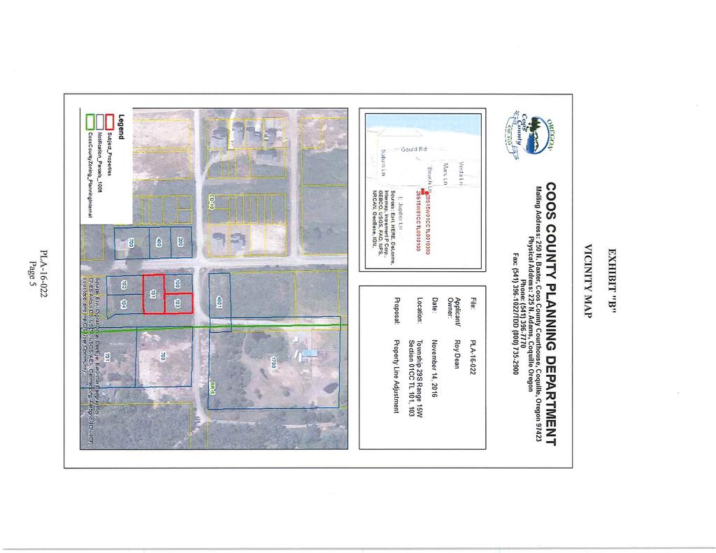
10 EXHIBIT "B" VICINITY MAP Page 5
11 EXHIBIT "C" STAFF REPORT File Number: Applicant: Roy Dean Roy Dean Account Number: Map Number: Property Owner: S1501CC DEAN, ROY A 720 CAROLINE ST SE BANDON, OR S1501CC DEAN ROY A PO BOX 1581 BANDON, OR Situs Address: Acreage: BEACH LOOP RD BANDON, OR Acres BEACH LN BANDON, OR Acres Zoning: Special Considerations: CONTROLLED DEVELOPMENT-10 (CD-10) ARCHAEOLOGICAL SITES (ARC) BANDON AIRPORT CONICAL ZONE (ABC) BANDON URBAN GROWTH BOUNDARY (BGB) NATIONAL WETLAND INVENTORY SITE (NWI) Reviewing Staff: Sierra Brown, Planning Specialist Date of Report: November 16, 2016 I. PROPOSAL CONTROLLED DEVELOPMENT- 10 (CD-10) ARCHAEOLOGICAL SITES (ARC) BANDON AIRPORT CONICAL ZONE (ABC) BANDON URBAN GROWTH BOUNDARY (BGB) NATIONAL WETLAND INVENTORY SITE (NWI) Request for Planning Director Approval of a property line adjustment to increase the acreage on tax lot 103 to accommodate a well, septic and dwelling. II. BACKGROUND INFORMATION Tax lot 101: May 23, 2016 a Zoning Clearance Letter (ZCL ) was issued for a septic site evaluation only. November 8, 2016 an address was issued to this property (AD ). Page 6
12 Tax Lot 103: May 23, 2016 a Zoning Clearance Letter (ZCL ) was issued for a septic site evaluation. October 25, 2016 a compliance determination was submitted for a dwelling and attached garage. November 8, 2016 an address was issued to this property (AD ). Request for comments were received from Mike Dado, Coos County Surveyor on November 9, A survey of the adjusted line will be required, because both parcels are not greater than 10 acres in size. III. PROPERTY DESCRIPTION AND PROPOSAL LOCATION: Tax lot 101 is accessed off of Beach Loop Road, and tax lot 103 is accessed off of Beach Lane. The subject properties are located south west of the City of Bandon. LAWFULLY CREATED: Tax lot 101 was lawfully created pursuant to Coos County Zoning and Land Development Ordinance (CCZLDO) , through the 1907 plat of Sunset City, and consists of lots 5 through 7 and 16 through 18 of block 19. Tax lot 103 was also, lawfully created pursuant to CCZLDO , through the 1907 plat of Sunset City and consists of lot 1 through 4 of block 19. IV. APPLICABLE CRITERIA & FINDINGS OF FACT SECTION PROCEDURE: 1. An application for a line adjustment or elimination shall be filed by the owners of all lots or parcels affected. The application shall be accompanied by an appropriate fee and contain the following information: a. Reason for the line adjustment; b. Vicinity map locating the proposed line adjustment or elimination in relation to adjacent subdivisions, partitions, other units of land and roadways; c. A plot plan showing the existing boundary lines of the lots or parcels affected by the line adjustment and the approximate location for the proposed adjustment line. The plot plan shall also show the approximate location of all structures within ten (10) feet of the proposed adjusted line; d. A current property report (less than 6 months old) indicating any taxes, assessment or other liens against the property, easements, restrictive covenants and rights-of-way, and ownerships of the property of the proposed development. A title report is acceptable. e. A notice of application and decision will be provided to any and all lien holders of record for the property that will be affected by the proposed adjustment. Page 7
13 Applicants should consult with any and all such lien holders prior to submittal of an application. FINDING: The purpose of this property line adjustment is to increase the acreage on tax lot 103 to accommodate a well, septic and dwelling. This application is found to be complete and contain all documents required by this section. There are no liens on either property. Therefore, these criteria have been met. 2. A line adjustment is permitted only where an additional unit of land is not created and where the lot or parcel reduced in size by the adjustment complies with the requirements of the applicable zone except that a line adjustment for the purpose of exchange or transfer of land between resource land owners shall be allowed so long as: FINDING: a. No parcel is reduced in size contrary to a condition under which it was formed; b. The resulting parcel sizes do not change the existing land use pattern (e.g. two conforming parcels must remain conforming; and c. Two non-conforming parcels may remain non-conforming; and, two parcels, one conforming and one non-conforming, may remain as such regardless of which parcel is non-conforming after the exchange or transfer). The lots were created in 1907 prior to any zoning regulations and at that time there were no size limits. These are considered to be legal non-conforming parcels pursuant to CCZLDO Therefore, the lots have not been reduced in size contrary to the condition under which they were formed. The resulting parcel sizes do not change the existing land use patter. They were and will remain non-conforming. Therefore, the proposal meets the criterion. 3. An encroachment of existing or planned structures will not be created within required setbacks as a result of the line adjustment. FINDING: No encroachment of existing structures will be created by adjusting the property boundary line. Therefore, this criterion has been met. Any future structures will be required to comply with the setback requirements in the applicable zoning district. Page 8
14 4. A line adjustment for a lot or parcel that contains a dwelling, not on a public sanitation system, and is less than an acre before the adjustment and further reduced as a result of the adjustment shall obtain documentation from Department of Environmental Quality (DEQ) that the sanitation system will still meet their requirements. FINDING: Both tax lots are less than an acre; therefore, as a condition of approval the applicant must submit documentation from Department of Environmental Quality (DEQ) that the sanitation system will meet their requirements or that the dwellings will be connected to a public sanitation system. Therefore, this criterion has been met. 5. In resource lands, a unit of land containing a dwelling, or approved for construction of a dwelling, cannot be adjusted with a vacant resource unit of land for the purpose of qualifying the vacant unit for a 160-acre dwelling. a. A resource unit of land less than 160 acres and containing a (preexisting) dwelling, or approved for construction of a dwelling, cannot be adjusted with a vacant resource unit of land for the purpose of qualifying the vacant unit for a 160-acre dwelling; b. A resource unit of land 160 acres or greater and containing a (preexisting) dwelling, or approved for construction of a dwelling, cannot be adjusted below 160 acres with a vacant resource unit of land for the purpose of qualifying the vacant unit for a 160-acre dwelling; c. A resource unit of land 160 acres or greater and containing a dwelling approved as a 160-acre dwelling, or approved for construction of a 160-acre dwelling, cannot be reduced below 160 acres for the purpose of qualifying the vacant unit for a 160-acre dwelling. FINDING: The purpose of this adjustment is to increase lot 103 in order to accommodate water well zone, septic leach field and create space for a dwelling. These properties are not resource zoned. Therefore, this criterion does not apply. 6. Same Designation: A line adjustment shall only be permitted where the sale or transfer of ownership is made between abutting owners of like designated lands, residential lands, commercial lands, industrial lands, resource lands, and estuary zoned lands unless an existing structure encroaches over an existing property boundary or the boundary line adjustment is required to comply with requirements of the State Department of Environmental Quality for a subsurface sewage system. FINDING: The property line adjustment will not cross zone boundaries. Therefore, this criterion has been addressed. SECTION EASEMENTS AND ACCESS: Page 9
15 A line adjustment shall have no affect on existing easements or access. Access shall not be eliminated through a property line adjustment process. If an access is potentially affected then an easement may be created for access to comply with this criterion. FINDING: Both properties will still have their same access, tax lot 101 will have access through Beach Loop Road and tax lot 103 will have access through Beach Lane. Therefore, this criterion has been met. V. DECISION: The proposed Property Line Adjustment meets the requirements of the Coos County Zoning and Land Development Ordinance, with conditions as listed above. Page 10
16 . EXHIBIT "D" Page 11
NOTICE OF LAND USE DECISION BY THE COOS COUNTY PLANNING DIRECTOR
 NOTICE OF LAND USE DECISION BY THE COOS COUNTY PLANNING DIRECTOR Date of this Decision October 18, 2016 Coos County Planning 225 N. Adams St. Coquille, OR 97423 http://www.co.coos.or.us/ Phone: 541-396-7770
NOTICE OF LAND USE DECISION BY THE COOS COUNTY PLANNING DIRECTOR
 NOTICE OF LAND USE DECISION BY THE COOS COUNTY PLANNING DIRECTOR This notice is to serve as public notice and decision notice and if you have received this notice by mail it is because you are a participant,
Date of Report: Tuesday, September 23, 2014 Appeal Deadline: Wednesday, October 08, 2014
 Coos County Planning Department Coos County Courthouse Annex, Coquille, Oregon 97423 Mailing Address: 250 N. Baxter, Coos County Courthouse, Coquille, Oregon 97423 Physical Address: 225 N. Adams, Coquille,
NOTICE OF LAND USE DECISION BY THE COOS COUNTY PLANNING DIRECTOR
 NOTICE OF LAND USE DECISION BY THE COOS COUNTY PLANNING DIRECTOR Coos County Planning 225 N. Adams St. Coquille, OR 97423 http://www.co.coos.or.us/ Phone: 541-396-7770 Fax: 541-396-1022 This notice is
NOTICE OF LAND USE DECISION BY THE COOS COUNTY PLANNING DIRECTOR
 NOTICE OF LAND USE DECISION BY THE COOS COUNTY PLANNING DIRECTOR Coos County Planning 225 N. Adams St. Coquille, OR 97423 http://www.co.coos.or.us/ Phone: 541-396-7770 Fax: 541-396-1022 Date of Notice:
Staff Report Planning Commission NUEZ, LEE T & MARISSA M N DAVIS RD LODI, CA HWY 101 BANDON, OR 97411
 Staff Report Planning Commission Coos County Planning 225 N. Adams St. Coquille, OR 97423 http://www.co.coos.or.us/ Phone: 541-396-7770 Fax: 541-396-1022 File Number: HBCU-17-002 Account Number(s): Map
Umatilla County Department of Land Use Planning
 Umatilla County Department of Land Use Planning 216 SE 4 th ST, Pendleton, OR 97801, (541) 278-6252 Property Line Adjustment, Type V Application & Information Packet PROCESSING THE APPLICATION The application
File Number: ACU Reviewed by: Alex Murphy, GIS Planner I I. PROPERTY INFORMATION S1402CD-00101
 Coos County Planning Department Coos County Courthouse Annex, Coquille, Oregon 97423 Mailing Address: 250 N. Baxter, Coos County Courthouse, Coquille, Oregon 97423 Physical Address: 225 N. Adams, Coquille,
*NOTE: As per SCC , Property owner is required to sign the application if the Agent does not have written proof of authorization.
 BOUNDARY LINE ADJUSTMENT APPLICATION STEVENS COUNTY LAND SERVICES PLANNING DIVISION Street Address: 260 S. Oak Courthouse Annex, Colville, WA 215 S. Oak Courthouse Annex, Colville, WA 99114 Phone: 509-684-2401
STAFF REPORT. Date of Report: Thursday, June 04, 2015 Appeal Deadline Friday, June 19, Property Information
 Coos County Planning Department Coos County Courthouse Annex, Coquille, Oregon 97423 Mailing Address: 250 N. Baxter, Coos County Courthouse, Coquille, Oregon 97423 Physical Address: 225 N. Adams, Coquille,
Staff Report Amended Amended to correct file number. File Number: CD Reviewed by: Alex Murphy, GIS Planner I
 Coos County Planning Department Coos County Courthouse Annex, Coquille, Oregon 97423 Mailing Address: 250 N. Baxter, Coos County Courthouse, Coquille, Oregon 97423 Physical Address: 225 N. Adams, Coquille,
Umatilla County Department of Land Use Planning
 Umatilla County Department of Land Use Planning 216 SE 4 th ST, Pendleton, OR 97801, (541) 278-6252 PROCESSING TYPE I & III APPLICATIONS Land Division, Type I - IV Supplemental Application & Information
LAND USE APPLICATION
 Lincoln County Department of Planning & Development 210 SW 2nd Street, Newport, OR 97365 Phone (541) 265-4192 Fax (541) 265-6945 LAND USE APPLICATION TO BE COMPLETED BY STAFF Conditional Use Non-Conforming
CHAPTER 91. SUBDIVISIONS, PARTITIONS, and PROPERTY LINE ADJUSTMENTS (Short Title; Definitions)
") CHAPTER 91 SUBDIVISIONS, PARTITIONS, and PROPERTY LINE ADJUSTMENTS (Short Title; Definitions) 91.110. Short Title 91.120. Purpose 91.150 Definitions 91.200 Procedures for Subdivisions and Partitions 91.210
CHAPTER 91 SUBDIVISIONS, PARTITIONS, and PROPERTY LINE ADJUSTMENTS (Short Title; Definitions) 91.110. Short Title 91.120. Purpose 91.150 Definitions 91.200 Procedures for Subdivisions and Partitions 91.210
FOR OFFICE USE ONLY BOUNDARY LINE ADJUSTMENT APPLICATION
 BOUNDARY LINE ADJUSTMENT APPLICATION STEVENS COUNTY LAND SERVICES PLANNING DIVISION Street Address: 260 S. Oak Courthouse Annex, Colville, WA 215 S. Oak Courthouse Annex, Colville, WA 99114 Phone: 509-684-2401
610 LAND DIVISIONS AND PROPERTY LINE ADJUSTMENTS OUTSIDE A UGB
 ARTICLE VI: LAND DIVISIONS AND PROPERTY LINE ADJUSTMENTS VI-21 610 LAND DIVISIONS AND PROPERTY LINE ADJUSTMENTS OUTSIDE A UGB 610-1 Property Line Adjustments (Property Line Relocation) A property line
MINOR SUBDIVISION INFORMATION
 A. POINTS OF CONTACT: MINOR SUBDIVISION INFORMATION Surveyor: Address: Phone #: Fax # E-Mail Address: Representative (If different from applicant): Address: Phone #: Fax # E-Mail Address: B. GENERAL INFORMATION:
CHAPTER 3. APPLICATION REVIEW AND DECISION
 CHAPTER 3. APPLICATION REVIEW AND DECISION 3.1 LAND USE PERMITS/DECISIONS... 1 3.1.1 General Provisions... 1 A) Land Use Permits Required... 1 B) Effect of Approval... 1 C) Zoning Information Sheet...
For Office Use Only. Permit No. Fee: $ $ per proposed lot (AN ADDITIONAL 10% CODE COMPLIANCE FEE WILL BE CHARGED)
") For Office Use Only Permit No. Fee: $1600 + $560.00 per proposed lot (AN ADDITIONAL 10% CODE COMPLIANCE FEE WILL BE CHARGED) LAND PARTITION FOREST (Conditional Use) Crook County Planning Department 300
For Office Use Only Permit No. Fee: $1600 + $560.00 per proposed lot (AN ADDITIONAL 10% CODE COMPLIANCE FEE WILL BE CHARGED) LAND PARTITION FOREST (Conditional Use) Crook County Planning Department 300
WESTON COUNTY FINAL PLAT APPLICATION
 WESTON COUNTY FINAL PLAT APPLICATION Property Owner: Mailing Address of owner: Telephone Number(s) of owner: Property Owner: Mailing Address of owner: Telephone Number(s) of owner: (If subdivider/applicant
Application Instructions for: Property Line Adjustment Outside Urban Growth Boundary (UGB)
") WASHINGTON COUNTY Dept. of Land Use & Transportation Planning and Development Services Current Planning 155 N. 1 st Avenue, #350-13 Hillsboro, OR 97124 Ph. (503) 846-8761 Fax (503) 846-2908 http://www.co.washington.or.us
WASHINGTON COUNTY Dept. of Land Use & Transportation Planning and Development Services Current Planning 155 N. 1 st Avenue, #350-13 Hillsboro, OR 97124 Ph. (503) 846-8761 Fax (503) 846-2908 http://www.co.washington.or.us
CHECKLIST FOR CUSTOMER Lawful Lot Determination
 CHECKLIST FOR CUSTOMER Lawful Lot Determination (LDO Section 10.2.1A) The following material must be submitted with a request for a lawful lot determination. Check off each item that you have included
Application for a Deminimus Development
 Okeechobee County Community Development Department 1700 NW 9 th Avenue, Suite A Okeechobee, FL 34972 Phone (863) 763-5548 Fax (863) 763-5276 planning@co.okeechobee.fl.us A deminimus development is the
SUBMITTAL REQUIREMENTS: The number indicates the number of copies for submittal (if applicable).
.") Office Use Only Preliminary Long Plat Long Subdivision Applicant Checklist PLANNING, COMMUNITY, & ECONOMIC DEVELOPMENT DEPARTMENT FINAL LONG PLAT LONG SUBDIVISION CHECKLIST Mailing Address: P.O. Box 547,
Office Use Only Preliminary Long Plat Long Subdivision Applicant Checklist PLANNING, COMMUNITY, & ECONOMIC DEVELOPMENT DEPARTMENT FINAL LONG PLAT LONG SUBDIVISION CHECKLIST Mailing Address: P.O. Box 547,
ALEXANDRIA TOWNSHIP METES & BOUNDS SUBDIVISION APPLICATION. Name of Applicant Phone. Property Address (E911#) Mailing Address Local Phone
 Mailing Address Local Phone") Application # Date Application Rec d / / (for office use only) Fee Collected $ ALEXANDRIA TOWNSHIP METES & BOUNDS SUBDIVISION APPLICATION Name of Applicant Phone Property Address (E911#) Mailing Address
Application # Date Application Rec d / / (for office use only) Fee Collected $ ALEXANDRIA TOWNSHIP METES & BOUNDS SUBDIVISION APPLICATION Name of Applicant Phone Property Address (E911#) Mailing Address
BRIDGETON SUBDIVISION APPLICATION CHECKLIST
 APPLICATION NAME AND # CHECKLIST COMPLETED BY: DATE: Signature and printed name BRIDGETON SUBDIVISION APPLICATION CHECKLIST TO SUBDIVISION APPLICANTS: The attached checklist is to assist you in the submission
SUBMITTAL REQUIREMENTS: The number indicates the number of copies for submittal (if applicable).
.") Office Use Only Preliminary Long Plat Long Subdivision Applicant Checklist PLANNING, COMMUNITY, & ECONOMIC DEVELOPMENT DEPARTMENT PRELIMINARY LONG PLAT LONG SUBDIVISION CHECKLIST Mailing Address: P.O.
Office Use Only Preliminary Long Plat Long Subdivision Applicant Checklist PLANNING, COMMUNITY, & ECONOMIC DEVELOPMENT DEPARTMENT PRELIMINARY LONG PLAT LONG SUBDIVISION CHECKLIST Mailing Address: P.O.
I. Subject Property Information This does not include any adjoining property that is not subject to this matter S
 Coos County Planning Department Coos County Courthouse Annex, Coquille, Oregon 97423 Mailing Address: 250 N. Baxter, Coos County Courthouse, Coquille, Oregon 97423 Physical Address: 225 N. Adams, Coquille,
SUBDIVISION APPLICATION CHECKLIST SKETCH PLAN PRELIMINARY PLAT FINAL PLAT
 RECEIVED STAMP SUBDIVISION APPLICATION CHECKLIST SKETCH PLAN PRELIMINARY PLAT FINAL PLAT A checklist of background information and submission requirements for processing of a sketch plan, preliminary plat
CHAPTER SUBDIVISION AND PARTITION REQUIREMENTS
 CHAPTER 17.172 SUBDIVISION AND PARTITION REQUIREMENTS Section Title Page 17.172.010 Purpose 2 17.172.020 General Definitions 2 Article I. General Regulations 17.172.040 Considerations for Approval or Denial
LISA ANDERSON-OGILVIE, AICP DEPUTY COMMUNITY DEVELOPMENT DIRECTOR AND PLANNING ADMINISTRATOR
 FOR MEETING OF: January 9, 2019 CASE NO.: VUL18-02 TO: FROM: HEARINGS OFFICER LISA ANDERSON-OGILVIE, AICP DEPUTY COMMUNITY DEVELOPMENT DIRECTOR AND PLANNING ADMINISTRATOR SUBJECT: VALIDATION OF UNITS OF
CHAPTER SUBDIVISION AND PARTITION REQUIREMENTS
 CHAPTER 16.33 SUBDIVISION AND PARTITION REQUIREMENTS Section Title Page 16.33.010 Purpose 2 16.33.020 General Definitions 2 Article I. General Regulations 16.33.040 Considerations for Approval or Denial
LAND USE APPLICATION - ADMINISTRATIVE Property Line Adjustment Review (Ministerial No Notice)
") LAND MANAGEMENT DIVISION Date Received: LAND USE APPLICATION - ADMINISTRATIVE Property Line Adjustment Review (Ministerial No Notice) PUBLIC WORKS DEPARTMENT 3050 N. DELTA HWY, EUGENE OR 97408 Planning:
LAND MANAGEMENT DIVISION Date Received: LAND USE APPLICATION - ADMINISTRATIVE Property Line Adjustment Review (Ministerial No Notice) PUBLIC WORKS DEPARTMENT 3050 N. DELTA HWY, EUGENE OR 97408 Planning:
Boundary Line Adjustment Application
 Boundary Line Adjustment Application A COMPLETE APPLICATION is required at the time of submittal. REQUIRED SUBMITTALS: 1. Application form 2. Application Fee - $500.00. 3. Current title report 4. Three
PENINSULA TOWNSHIP LAND DIVISION ORDINANCE TOWNSHIP OF PENINSULA COUNTY OF GRAND TRAVERSE, STATE OF MICHIGAN ORDINANCE NO OF 2012
 PENINSULA TOWNSHIP LAND DIVISION ORDINANCE TOWNSHIP OF PENINSULA COUNTY OF GRAND TRAVERSE, STATE OF MICHIGAN ORDINANCE NO OF 2012 AN ORDINANCE TO REGULATE THE DIVISION OF EXISTING PARCELS OF LAND PURSUANT
Planning Department Filing Fee of $ up to 3 lots $75.00 per each additional lot (subject to change) payable to Archuleta County.
 payable to Archuleta County.") Archuleta County Development Services Building & Planning Departments 1122 Hwy 84 P. O. Box 1507 Pagosa Springs, Colorado 81147 970-264-1390 Fax 970-264-3338 Lot Consolidation Submittal Checklist for the
Archuleta County Development Services Building & Planning Departments 1122 Hwy 84 P. O. Box 1507 Pagosa Springs, Colorado 81147 970-264-1390 Fax 970-264-3338 Lot Consolidation Submittal Checklist for the
Easement Preparation and Submittal Procedures and Checklist
 Platte Canyon Water and Sanitation District Easement Preparation and Submittal Procedures and Checklist These procedures have been prepared in order to provide general guidelines for the submittal of information
ST. TAMMANY PARISH PATRICIA P. BRISTER PARISH PRESIDENT
 TENTATIVE SUBDIVISION APPROVAL CHECK SHEET Revised October 5, 2018 The Developer shall submit a request for Tentative Plan Review to the Department of Planning & Development in the appropriate format.
MINOR SUBDIVISION APPLICATION
 Planning and Development 510 N. Baker St. Mount Dora, FL 32757 352-735-7112 Fax: 352-735-7191 plandev@cityofmountdora.com Date: Project Name: MINOR SUBDIVISION APPLICATION 1. Applicant s Name: 2. Property
Date. A ppucnt. Address. CoIIeed by. Telephirne PARCEL #2: Town.ship. Thwn-sbip. RanJe. Rarue. Ta mt. Tx Lot. Ztine. Zone.
 HOOD RIVER COUNTY COMMUNITY DEVELOPMENT 601 STATE STREET HOOD RiVER, OR 97031-2093 PHONE 541-387-6840 FAX 541-387-6873 Email: plan.dept@co.hood_river.or.us PROPERTY LINE ADJUSTMENT APPLICATION Measure
Community Development Department 333 Broadalbin Street SW, P.O. Box 490 Albany, OR 97321
 SUMMARY Community Development Department 333 Broadalbin Street SW, P.O. Box 490 Albany, OR 97321 STAFF REPORT Application for Tentative Partition Plat Review Planning File PA-06-17 Phone: 541-917-7550
IV. REVIEW PROCEDURES FOR MINOR SUBDIVISIONS
 IV. REVIEW PROCEDURES FOR MINOR SUBDIVISIONS IV-A. General Minor subdivisions create five or fewer lots from a tract of record, each lot of which has legal and physical access. If the tract of record proposed
APPLICATION PROCESSING
 MAJOR SUBDIVISION 1810 E. HAZELTON AVENUE, STOCKTON CA 95205 BUSINESS PHONE: (209) 468-3121 BUSINESS HOURS: 8:00 A.M. TO 5:00 P.M..(Monday through Friday) APPLICATION PROCESSING STEPS STEP 1 STEP 2 CHECK
Reference Document Do Not Copy
 Parcel Map, Division Into Large Parcels, and Reversion to Acreage Map Review Procedures The parcel map process in Churchill County is designed to provide a mechanism in order to divide a parcel or parcels
B. The proposed parcel(s) of land shall be in compliance with the current zoning requirements.
 of land shall be in compliance with the current zoning requirements.") SECTION 14-900 SUBDIVISION EXEMPTION 14-901 INTENT To establish criteria and a review process whereby the Board of County Commissioners may grant Exemptions from the definition of the terms subdivision
SECTION 14-900 SUBDIVISION EXEMPTION 14-901 INTENT To establish criteria and a review process whereby the Board of County Commissioners may grant Exemptions from the definition of the terms subdivision
NASSAU COUNTY BUILDING DEPARTMENT MOBILE/MANUFACTURED HOME APPLICATION CHECKLIST
 Permit # Ap# NASSAU COUNTY BUILDING DEPARTMENT MOBILE/MANUFACTURED HOME APPLICATION CHECKLIST New Replacement Single Wide Double Wide Triple Wide Quad Mftr d Add INSTRUCTIONS: Complete Section A only.
APPLICATION PROCESSING STEPS
 LOT LINE ADJUSTMENT 1810 E. HAZELTON AVENUE, STOCKTON CA 95205 BUSINESS PHONE: (209) 468-3121 Business Hours: 8:00 a.m. to 5:00 p.m. (Monday through Friday) APPLICATION PROCESSING STEPS STEP 1 CHECK WITH
Gates County Planning and Zoning
 Gates County Planning and Zoning PO Box 411, 200 Court Street, Gatesville, NC 27938 phone: 252-357-2411 fax: 252-357-0073 Application for Technical Review Committee For Staff Use Only: Date: Application
CHARTER TOWNSHIP OF LYON APPLICATION FOR LAND DIVISION (LOT SPLIT)
") File #: Date Submitted: CHARTER TOWNSHIP OF LYON APPLICATION FOR LAND DIVISION (LOT SPLIT) NOTICE TO APPLICANT: Applications for land divisions (also called lot splits ) are reviewed in accordance with
File #: Date Submitted: CHARTER TOWNSHIP OF LYON APPLICATION FOR LAND DIVISION (LOT SPLIT) NOTICE TO APPLICANT: Applications for land divisions (also called lot splits ) are reviewed in accordance with
MINOR PLAT. The following documents are provided as required by the City of Conroe for use in the above titled platting submittals:
 Public Works - Engineering Division CITY OF CONROE MINOR PLAT The following documents are provided as required by the City of Conroe for use in the above titled platting submittals: Submittal Questionnaire
CERTIFICATE OF EXEMPTION APPLICATION FOR OFFICE USE ONLY
 CERTIFICATE OF EXEMPTION APPLICATION OTHER (i.e., Estate, Cemetery, Electric Facility, Wireless Services) STEVENS COUNTY LAND SERVICES PLANNING DIVISION Street Address: 260 S. Oak Courthouse Annex, Colville,
Title 17. Subdivisions
 Title 17 Subdivisions Chapters: 17.05 Introductory Provisions 17.10 Ordinance Compliance 17.15 Preliminary Review 17.20 Subdivision Plat Approval Procedure 17.25 Information on Tentative Plat for Proposed
A Final Plat will be reviewed concurrently with any other development review application(s) that is required.
 that is required.") RELATED FACTS TO KNOW: Adams County Recording Requirements, Annexation, Common Wall Subdivision, Development Plan (PUD Development Permit), Fees, Helpful Contact Information, Lot Line Adjustment, Neighborhood
RELATED FACTS TO KNOW: Adams County Recording Requirements, Annexation, Common Wall Subdivision, Development Plan (PUD Development Permit), Fees, Helpful Contact Information, Lot Line Adjustment, Neighborhood
COMMUNITY DEVELOPMENT DEPARTMENT 333 Broadalbin Street SW, P.O. Box 490 Albany OR 97321
 COMMUNITY DEVELOPMENT DEPARTMENT 333 Broadalbin Street SW, P.O. Box 490 Albany OR 97321 NOTICE OF DECISION DATE OF NOTICE: August 16, 2016 FILE: TYPE OF APPLICATION: REVIEW BODY: SD-01-16 Ph: 541-917-7550
CONDOMINIUM REGULATIONS
 ARTICLE 37 CONDOMINIUM REGULATIONS SECTION 37.01. Purpose The purpose of this Article is to regulate projects that divide real property under a contractual arrangement known as a condominium. New and conversion
Walton County Planning and Development Services
 Walton County Planning and Development Services 31 Coastal Centre Boulevard, Suite 100 47 N 6 th Street Santa Rosa Beach, Florida 32459 DeFuniak Springs, Florida 32433 Phone 850-267-1955 Phone 850-892-8157
PUBLIC WORKS - COMMUNITY DEVELOPMENT. Staff Report. Land Division (Tentative Partition Plat) PA October 23, 2018
 PA October 23, 2018") PUBLIC WORKS - COMMUNITY DEVELOPMENT 333 Broadalbin Street SW, PO Box 490, Albany, Oregon 97321-0144 BUILDING 541-917-7553 PLANNING 541-917-7550 Staff Report Land Division (Tentative Partition Plat) PA-08-18
PUBLIC WORKS - COMMUNITY DEVELOPMENT 333 Broadalbin Street SW, PO Box 490, Albany, Oregon 97321-0144 BUILDING 541-917-7553 PLANNING 541-917-7550 Staff Report Land Division (Tentative Partition Plat) PA-08-18
COLUMBIA COUNTY LAND DEVELOPMENT SERVICES COURTHOUSE 230 STRAND ST. HELENS, OREGON (503) APPLICANT: Name:
 APPLICANT: Name:") COLUMBIA COUNTY LAND DEVELOPMENT SERVICES COURTHOUSE 230 STRAND ST. HELENS, OREGON 97051 (503) 397-1501 PARTITION General Information File No. APPLICANT: Name: Mailing address: City State Zip Code Phone
COLUMBIA COUNTY LAND DEVELOPMENT SERVICES COURTHOUSE 230 STRAND ST. HELENS, OREGON 97051 (503) 397-1501 PARTITION General Information File No. APPLICANT: Name: Mailing address: City State Zip Code Phone
Manufactured Structure Notice of Sale/Change of Ownership
 Manufactured Structure Notice of Sale/Change of ship NOTICE OF SALE/CHANGE OF OWNERSHIP INSTRUCTIONS It is the responsibility of the seller(s) to file this form and all supporting documents with the taxation/assessment
LISA ANDERSON-OGILVIE, AICP DEPUTY COMMUNITY DEVELOPMENT DIRECTOR AND PLANNING ADMINISTRATOR
 FOR MEETING OF: December 12, 2018 CASE NO.: VUL18-01 TO: FROM: HEARINGS OFFICER LISA ANDERSON-OGILVIE, AICP DEPUTY COMMUNITY DEVELOPMENT DIRECTOR AND PLANNING ADMINISTRATOR SUBJECT: VALIDATION OF UNIT
CITY OF NOVI LAND DIVISION INSTRUCTIONS
 CITY OF NOVI LAND DIVISION INSTRUCTIONS All applications for land division in the City of Novi must be in compliance with Chapter 32 of the City of Novi Code of Ordinances and with the Land Division Act,
FINAL PLAT APPLICATION
 FINAL PLAT APPLICATION (Page 1 of 3) LEGAL OWNER(s): NAME: STREET ADDRESS OWNER(s): CITY, STATE, ZIP CODE: PHONE NUMBER: BILLING ADDRESS: NAME OF ENGINEER/SURVEYOR: Engineer/Surveyor Address, Phone: PROPERTY
Administrative Application Duplex Subdivisions
 Department of Community Development 75 South Frontage Road Vail, CO 81657 Tel: 970-479-2128 www.vailgov.com Development Review Coordinator Administrative Application Duplex Subdivisions General Information:
MAJOR SUBDIVISION PRELIMINARY PLAT CHECKLIST
 TOWNSHIP OF EGG HARBOR PLANNING BOARD/ZONING BOARD OF ADJUSTMENT 3515 BARGAINTOWN ROAD EGG HARBOR TOWNSHIP, NJ 08234 MAJOR SUBDIVISION PRELIMINARY PLAT CHECKLIST The following checklist is designed to
FINAL PLAN CHECKLIST
 FINAL PLAN CHECKLIST Subdivision Name: Subdivision Number: Project Number: REVIEW CRITERIA Plans: A final plan shall be on a 24 x 36 sheet at a scale that is no smaller than 1 = 40 and shall contain all
SHORT PLAT APPLICATION CHECKLIST City of White Salmon. Application completed with notarized signatures
 SHORT PLAT APPLICATION CHECKLIST City of White Salmon Application completed with notarized signatures Road Classification as assigned by City Public Works Director City Public Works Director Certification
KLAMATH COUNTY PLANNING DEPARTMENT Government Center 305 Main St., Klamath Falls, Oregon Phone Option #4 Fax
 KLAMATH COUNTY PLANNING DEPARTMENT Government Center 305 Main St., Klamath Falls, Oregon 97601 Phone 541-883-5121 Option #4 Fax 541-885-3644 Land Partition Application Submittal Requirements (Please include
TENTATIVE MAP APPLICATION GUIDE (BCC 20-1)( 20-2 to )( to 20-91)( to )
( 20-2 to )( to 20-91)( to )") Butte County Department of Development Services PERMIT CENTER 7 County Center Drive, Oroville, CA 95965 Planning Division Phone 530.552.3701 Fax 530.538.7785 Email dsplanning@buttecounty.net FORM NO PLG-05
Butte County Department of Development Services PERMIT CENTER 7 County Center Drive, Oroville, CA 95965 Planning Division Phone 530.552.3701 Fax 530.538.7785 Email dsplanning@buttecounty.net FORM NO PLG-05
LYONS PLANNING COMMISSION MEETING & PUBLIC HEARING Tuesday, January 10, 2017, Meeting: 6:30 pm Hearing: 7:00 pm AGENDA
 LYONS PLANNING COMMISSION MEETING & PUBLIC HEARING Tuesday, January 10, 2017, Meeting: 6:30 pm Hearing: 7:00 pm AGENDA We welcome you to today s meeting of the Lyons Planning Commission. This is an open
APPLICATION REVIEW CHECKLISTS
 APPLICATION REVIEW CHECKLISTS The following must be submitted with and are part of each application. No application is complete until all required documentation has been submitted to the Community Development
DEPARTMENT OF FISH AND WILDLIFE ENVIRONMENTAL FILING FEES (Fish and Game Code 711.4)
") PARCEL MAP PROCESS DEPARTMENT OF PLANNING AND BUILDING SERVICES 707 Nevada Street, Suite 5 Susanville, CA 96130-3912 (530) 251-8269 (530) 251-8373 (fax) www.co.lassen.ca.us A subdivision is any division
PARCEL MAP PROCESS DEPARTMENT OF PLANNING AND BUILDING SERVICES 707 Nevada Street, Suite 5 Susanville, CA 96130-3912 (530) 251-8269 (530) 251-8373 (fax) www.co.lassen.ca.us A subdivision is any division
BOUNDARY LINE ADJUSTMENT APPLICATION
 OFFICE 518.747.5212 --------------FAX 518.747.2493 (Clerk s Office Use Only) BOUNDARY LINE ADJUSTMENT APPLICATION APPLICATION NO: DATE : FEE PAID: Requirements, Fees and Instructions (Please use dark blue
TOWNSHIP OF BORDENTOWN LAND DEVELOPMENT APPLICATION CHECKLIST. General Requirements for all Applications
 TOWNSHIP OF BORDENTOWN LAND DEVELOPMENT APPLICATION CHECKLIST This CHECKLIST has been adopted in accordance with Section 25:807 of the Land Development Ordinance of the Township of Bordentown and will
FOR OFFICE USE ONLY BOUNDARY LINE ADJUSTMENT APPLICATION
 BOUNDARY LINE ADJUSTMENT APPLICATION ONE PROPERTY OWNER STEVENS COUNTY LAND SERVICES PLANNING DIVISION Street Address: 260 S. Oak Courthouse Annex, Colville, WA Mailing Address: 215 S. Oak Courthouse Annex,
I. Requirements for All Applications. C D W
 108-16.1. Application checklists. Checklist for Required Submissions to the Planning Board or Zoning Board of Adjustment of Monroe Township All required submissions are to be made to the Administrative
APPLICATION FOR VARIANCE Chapter 50, Land Development Code Levy County, Florida
 Filing Date: Petition Number: Fee: $ 350.00 Validation Number: TO THE LEVY COUNTY BOARD OF ADJUSTMENT AND CODE ENFORCEMENT: A Variance is to grant relief to a person from the requirements of this Ordinance
APPLICATION FOR LOT SPLIT
 APPLICATION FOR LOT SPLIT ELIGIBILITY Section 12.09.01 of the Land Development Code provides for review and approval of lot split, which shall include any of the following: 1. The division of a single
BOSSIER CITY PARISH METROPOLITAN PLANNING COMMISSION 620 Benton Rd. Bossier City, LA Phone: Fax: PRELIMINARY PLAT
 (OFFICE USE ONLY) Application Fee: Paid: Date: CASE # Project Information BOSSIER CITY PARISH METROPOLITAN PLANNING COMMISSION 620 Benton Rd. Bossier City, LA 71111 Phone: 318-741-8824 Fax: 318-741-8827
I. PROPERTY INFORMATION. Date of Report: Thursday, March 24, 2016 Appeal Deadline: Friday, April 08, 2016 APPROVED WITH CONDITIONS
 Coos County Planning Department Coos County Courthouse Annex, Coquille, Oregon 97423 Mailing Address: 250 N. Baxter, Coos County Courthouse, Coquille, OR 97423 Physical Address: 225 N. Adams, Coquille,
City of Clever Planning & Zoning Department P.O. Box 52 Clever, MO QUALIFICATIONS FOR MINOR SUBDIVISIONS
 QUALIFICATIONS FOR MINOR SUBDIVISIONS All subdivision of land not otherwise classified as a major subdivision shall be classified as a minor subdivision and shall be subject to the procedures adopted by
FINAL PLAT. Community Development Department 8101 Ralston Road Arvada, Colorado 80002
 FINAL PLAT Community Development Department 8101 Ralston Road Arvada, Colorado 80002 September 2015 FINAL SUBDIVISION PLAT Final Subdivision Plat Review Applications for a Final Plat shall be submitted
ARTICLE SINGLE FAMILY SITE CONDOMINIUM DEVELOPMENT STANDARDS
 ARTICLE 28.00 SINGLE FAMILY SITE CONDOMINIUM DEVELOPMENT STANDARDS Section 28.01 PURPOSE The purpose of this Article is to recognize that conventional single family developments, traditionally developed
ARTICLE 13 CONDOMINIUM REGULATIONS
 ARTICLE 13 CONDOMINIUM REGULATIONS Section 13.01 Purpose. The purpose of this Article is to regulate projects that divide real property under a contractual arrangement known as a condominium. New and conversion
(if more than one, give square footage for each) ANNEXATION LOT LINE Adjustments PRE/FINAL PLAT SPECIAL USE PERMIT
 ANNEXATION LOT LINE Adjustments PRE/FINAL PLAT SPECIAL USE PERMIT") Planning Commission Application Building & development office 915 Third ST. Rawlins WY ph. 307-328-4599 fax. 307-328-4590 PROJECT REVIEW: GENERAL INFORMATION Project name: OFFICE USE ONLY Site address
Planning Commission Application Building & development office 915 Third ST. Rawlins WY ph. 307-328-4599 fax. 307-328-4590 PROJECT REVIEW: GENERAL INFORMATION Project name: OFFICE USE ONLY Site address
APPLICATION CHECKLIST
 DEPARTMENT OF PLANNING AND COMMUNITY DEVELOPMENT 1010 10TH Street, Suite 3400, Modesto, CA 95354 Phone: 209.525.6330 Fax: 209.525.5911 Form Available Online: http://www.stancounty.com/planning/applications.shtm
LAND USE PERMIT APPLICATION
 LAND USE PERMIT APPLICATION Date Application No. TYPE OF PERMIT Subdivision Short Plat Conditional Use Binding Site Plan Final Plat Final Short Plat Variance Final Binding Site Plan Plat Amendment Short
Guide to Minor Developments
 Guide to Minor Developments Introduction The Douglas County (DCD) is committed to providing open, transparent application processes to the public. This Guide is provided to assist anyone interested in
MINOR SUBDIVISION PLAT
 MINOR SUBDIVISION PLAT Community Development Department 8101 Ralston Road Arvada, Colorado 80002 MINOR SUBDIVISION PLAT Subdivisions consisting of five (5) or fewer lots are eligible for the minor subdivision
LISA ANDERSON-OGILVIE, AICP DEPUTY COMMUNITY DEVELOPMENT DIRECTOR AND PLANNING ADMINISTRATOR
 FOR MEETING OF: February 13, 2019 CASE NO.: VUL18-04 TO: FROM: HEARINGS OFFICER LISA ANDERSON-OGILVIE, AICP DEPUTY COMMUNITY DEVELOPMENT DIRECTOR AND PLANNING ADMINISTRATOR SUBJECT: VALIDATION OF UNITS
Project: Sunset Primary School Property Minor Partition Application Date: October 26, 2015 To:
 319 SW Washington, Suite 914 Portland, OR 97204 T 503 224 6681 bainbridgedesign.com Transmittal Project: Property Date: October 26, 2015 To: Peter Spir West Linn Planning Department 22500 Salamo Road West
MINOR SUBDIVISION PLAT
 MINOR SUBDIVISION PLAT Community Development Department 8101 Ralston Road Arvada, Colorado 80002 September 2015 MINOR SUBDIVISION PLAT Subdivisions consisting of five (5) or fewer lots are eligible for
JOINT PLANNING BOARD APPLICATION FORM
 JOINT PLANNING BOARD APPLICATION FORM TOWNSHIP OF RIVER VALE 406 RIVERVALE ROAD RIVER VALE, NJ 07675 The application, with supporting documentation, must be filed with the Administrative Officer to the
A lot line or terminology adjustment will be reviewed concurrently with any other development review application(s) that are required.
 that are required.") RELATED FACTS TO KNOW: Adams County Recording Requirements, Annexation, Common Wall Subdivision, Development Plan (PUD Development Permit), Fees, Helpful Contact Information, Neighborhood Meeting, Park
RELATED FACTS TO KNOW: Adams County Recording Requirements, Annexation, Common Wall Subdivision, Development Plan (PUD Development Permit), Fees, Helpful Contact Information, Neighborhood Meeting, Park
Highlands County, Florida Variance Application
 Highlands County, Florida Variance Application SECTION I. THIS SECTION FOR STAFF USE ONLY! Date Received: AMOUNT OF FEE RECEIPT # TAX MAP # CASE B.O.A. # HEARING DATE: B.O.A. - DATE ADOPTED: SECTION II.
CITY OF SARALAND PRELIMINARY SUBDIVISION PLAT REVIEW
 PRELIMINARY SUBDIVISION PLAT REVIEW Application Number: Date Plat Submitted: Name of Subdivision: Name of Owner: Owner Address: (Street or P.O. Box) Telephone #: (City) (State) (Zip) E-mail: Name of Authorized
SKETCH PLAN REVIEW SPECIAL EXCEPTION, SPECIAL REVIEW,
 www.larimer.org Planning Department 200 W. Oak Street 3 rd Floor Fort Collins, CO 80521 970-498-7683 SKETCH PLAN REVIEW SKETCH PLAN REVIEW for Conservation Developments, Planned Land Divisions, Subdivisions,
TILLAMOOK COUNTY LAND DIVISION ORDINANCE TABLE OF CONTENTS SECTION NUMBER & TITLE
 TILLAMOOK COUNTY LAND DIVISION ORDINANCE TABLE OF CONTENTS SECTION NUMBER & TITLE PAGE INTRODUCTION 1 Purpose...3 2 Definitions...4 3 Scope of Regulations...8 4 Pre-Application Meeting; Background Information...8
TO: Glynn County Islands Planning Commission. Eric Landon, Planner II. PP2754 Stones Throw Cottages. DATE: February 6, 2014
 COMMUNITY DEVELOPMENT DEPARTMENT Planning and Zoning Division 1725 Reynolds Street, Suite 200, Brunswick, GA 31520 Phone: 912-554-7428/Fax: 1-888-252-3726 TO: Glynn County Islands Planning Commission FROM:
Minor Subdivision Application
 FOR PLANNING USE ONLY Application # SD Application Fee $1,000.00 Receipt No. Filing Date Completeness Date Minor Subdivision Application A. PROJECT INFORMATION 1. Project Name: 2. Address of Subject Property:
LYON COUNTY TITLE 15 LAND USE AND DEVELOPMENT CODE LAND DIVISION REGULATIONS CHAPTERS October 19, 2017 Ordinance Draft DRAFT
 DRAFT LYON COUNTY TITLE 15 LAND USE AND DEVELOPMENT CODE LAND DIVISION REGULATIONS CHAPTERS 15.600 15.607 October 19, 2017 Ordinance Draft This page left blank intentionally DRAFT DRAFT Lyon County Contents