BLACKFIN SHOPPES GMP ZON I TEM #3. Staff Report to the Municipal Planning Board July 19, Location Map S UMMARY.
|
|
|
- Rosaline Bond
- 5 years ago
- Views:
Transcription


1 Staff Report to the Municipal Planning Board July 19, 2016 GMP ZON I TEM #3 BLACKFIN SHOPPES Location Map Subject Site S UMMARY Owners Edgar Yates Colleen Yates, Clifton Ackerman & Joy Ackerman Applicant Javier Omana CPH, Inc. Project Planner Colandra Jones, AICP Property Location: The subject property is located west of Narcoossee Road, north of Tavistock Lakes Boulevard, and south of Tyson Road (±14.63 acres, District 1). Applicant s Request: 1. GMP amendment to change the future land use designation from Conservation to Urban Village for 1.52 acres and change the future land use from Urban Village to Conservation for 0.28 acres. 2. PD amendment to increase the development program from 37,000 square feet to 75,000 square feet of mixed use development. Staff s Recommendation: Approval of the request, subject to the conditions in the staff report. Public Comment Courtesy notices were mailed to property owners within 400 ft. of the subject property on July 8, As of the published date of this report, staff has not received any comments from the public concerning this request. Updated: July 11, 2016


2 Page 2 F UTURE LAND USE MAP


3 Page 3 Z ONING MAP DRAFT
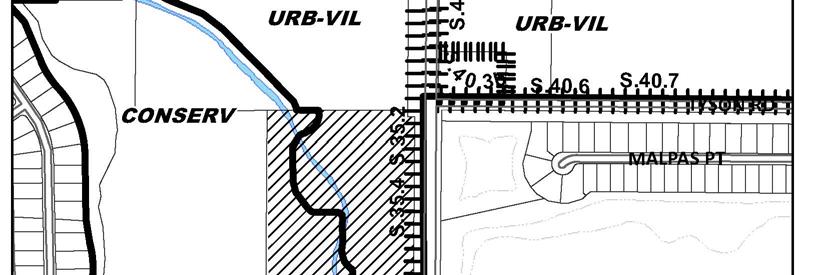
4 Page 4 P ROJECT ANALYSIS Project Description The subject property is located west of Narcoossee Road, north of Tavistock Lakes Boulevard, and south of Tyson Road and is approximately acres in size. The subject property currently has a cell tower on site and is used as a tree farm. The applicant has requested to change the future land use designation from Conservation to Urban Village for 1.52 acres. The applicant is also proposing to increase the size of the wetlands in other areas of the site, for an increase of 0.28 acres. The net impact is 1.24 acres. Also, the request includes an amendment to the PD to increase the development program from 37,000 square feet to 75,000 square feet of mixed use development. Project Context and Land Use Compatibility As shown in the table below, the surrounding uses include Lake Nona High School to the north, Conservation to the west, the Lake Nona Gateway office building and Conservation to the south, and Eagle Creek single family residential neighborhood and golf course to the east located in the County. The proposed Urban Village designation would be compatible with the surrounding uses. Table 1 Project Context Future Land Use Zoning Surrounding Use North Urban Village PD Lake Nona High School East PD (Orange County) PD (Orange County) Single Family Residential & Golf Course South Urban Village & Conservation PD Lake Nona Gateway Office & Wetlands West Conservation PD Primary Conservation Network Consistency with 163, Florida Statutes The proposed GMP amendment is being processed as a small scale amendment to the Official Future Land Use Map in accordance with the requirements of Chapter , Florida Statutes. As provided in Chapter 163, small scale amendments require only one public hearing before City Council (the adoption hearing) and are not subject to review by the State Department of Economic Opportunity Division of Community Planning unless challenged by an affected party within 30 days of the adoption hearing. If not challenged, the amendment is effective 31 days after the adoption. Conformance with the GMP Urban Village Future Land Use Designation Objective 2.4 and Policy of the Future Land Use Element provide standards relating to the Urban Village future land use designation. A portion of Policy states: The Urban Village future land use designation provides for a mixture of land uses and intensities within a development site in order to preserve conservation areas, to reduce public investment in provision of services, to encourage flexible and creative site design and to provide sites for schools, recreation and other public facilities which provide an area-wide benefit to the community. The Urban Village future land use designation is specifically intended to provide a means of streamlining the development review process where a DRI, a Sector Plan, and/or Master Plan, have already fully accounted for the impacts of development. The designation shall be structured to ensure that the Urban Village are compatible with existing or projected surrounding land uses, taking into consideration environmental constraints, health and safety issues, and the appropriateness and potential impact of the Urban Village on adjacent existing and future land uses. Environmental Conservation Element Policy states that all projects requiring Municipal Planning Board and City Council review shall provide an Environmental Assessment. Developments exempt from this requirement includes those located within the Urbanized Disturbed Lands are shown in Figure C-1 of the Conservation Element. According to Figure C-1 of the Conservation Element, the subject property lies outside the Urbanized Disturbed Land area. A Level C Environmental Assessment was performed. Of the total acres, approximately 7.55 acres are part of the Primary Conservation Network within the Southeast Orlando Sector Plan. The applicant is proposing to impact approximately 1.52 acres of the Primary Conservation Network on their property. Also within Conservation Element Policy 1.4.1, it states, Because the state and federal governments maintain comprehensive regulations relating to the protection of wetlands, the City shall defer to the regulatory oversight of the appropriate state and federal agencies for the protection of endangered and threatened species, and wetlands (including Protected Wetlands designated at Figure C-2 Part A and Part B) According Conservation Element Figure C-2 Part B, the proposed impacted wetland is a Tier One Protected Wetland. The proposed impact, 1.52 acres, is part of a larger system that is approximately 188 acres in size. Conservation Policy states, The remov-
5 Page 5 al, alteration, or encroachment within an area designated as a Protected Wetland shall only be allowed in order to accommodate low density and intensity land uses. It is the intention of the City to restrict development in Protected Wetlands to those activities that have minimum or no post-development impacts upon the functions of the wetland, so that no net loss of functions results from the activity The removal, alteration, or encroachment within an area designated as a Protected Wetland shall only be allowed where the applicant is able to demonstrate that there is no practical alternative which reduces or avoids the adverse impact to the wetland. If the applicant has demonstrated that there are no reasonable alternatives, impacts to these wetlands shall only be allowed to provide roadway and utility access to uplands which could not otherwise be developed. The applicant submitted the following reasoning to allow for the wetland impact: After extensive master planning of the site based on consultations with major national retailers, it has been determined that in order to respond to and accommodate the size and locational requirements of said national retailers, the current restrictive physical constraints must be adjusted. A acre impact to the site s wetlands is necessary in order to appropriately position certain buildings, and provide proper area for vehicular circulation, access, landscaping, required parking and back of house activities. The applicant has and will continue to avoid and minimize the wetland impact to the greatest extent practicable. Mitigation will be provided to compensate for wetland functions lost per requirements set forth by the SFWMD and ACOE. The mitigation program for Shoppes at Tyson Place has three components. To provide compensation for the proposed wetland impact, wetland creation areas are proposed. The size and location of the wetland creation areas will be determined through the SFWMD and ACOE permitting process. In addition, wetlands to remain in the post-development condition shall be placed under a conservation easement for protection in perpetuity and the purchase of mitigation bank credits shall complete the mitigation program. There is also a canal that located adjacent to the existing uplands and falls immediately west of the delineated wetland line. The function of this canal is that it receives runoff from the surrounding areas and conveys water to the south leaving the project area under a Narcoossee Road box culvert. An upland berm separated the canal from the forested wetland. It is the intention of the applicant as part of the SFWMD and ACOE permitting process to modify the canal including piping the canal through the site in order to maintain the flow of water. The design will be compliant with SFWMD requirements. According to the applicant s Environmental Assessment, the regulatory agency for this wetland system is South Florida Water Management District (SFWMD) and the U.S. Army Corp of Engineers. The applicant has indicated that they would be required to obtain authorization from SFWMD to develop within the impacted wetland. However, at the time of the MPB application submission to the City of Orlando, the property owner has not obtained the required authorization from either the SFWMD or Army Corp of Engineers. Of the overall ±188 acre designated Protected Wetland, the impact of the wetland would be 0.7% of that total wetland, which is very minimal impact. The applicant will still have to get the required authorization from SFWMD and satisfy any mitigation requirement from that agency. Public Facilities Analysis State law requires the City to perform a public facilities evaluation for GMP amendments that would increase the allowable density or intensity of a property. If the state and federal agencies grant the applicant to impact the wetlands, the proposed GMP amendment to change the future land use designation to Urban Village would permit densities on the subject property more than that permitted under the Conservation future land use designation. This evaluation assumes that the property is developed at the maximum intensity and density allowed by each future land use category. Typically, sites are developed at a lesser intensity, so these impacts represent an upper limit, rather than a true projection of demand. In the previous GMP amendment during the annexation process (Case #GMP ), the applicant requested to be included within the Southeast Orlando Sector Plan, which has provisions within Future Land Use Element Goal 4 and associated objectives and policies within the Growth Management Plan. In terms of the amount of development allowed within the Southeast Orlando Sector Plan, a portion of Policy states the following: The Southeast Orlando Sector Plan area shall accommodate approximately 13,300 residential units, 2.1 million square feet of retail, 3.3 million square feet of office, 1,950 hotel rooms, 4.7 million square feet of industrial space, and 600,000 square feet of civic/government space by the year The corresponding Southeast Sector Plan land use designation which will be applied to the subject property will be Village Center. According to Future Land Use Policy 4.1.9, the allowable uses in the Village Center designation is retail, services, grocery, restaurants, cinema, gas stations, offices, hospitals, single family and multi-family residential, civic and other uses consistent with the City s AC-1 zoning district. With the Southeast Orlando Sector Plan s allocation, the retail square footage takes into account the demand on public facilities in this area. No changes to the development program in Future Land Use Policy are proposed. Therefore, a public facilities analysis is not needed for this proposal.
6 Page 6 Conformance with the LDC The subject property is currently approved for the zoning classification of PD. The property owner is requesting an amendment to change the development program from 37,000 square feet to 75,000 square feet of mixed use development. Section of the LDC requires that all rezonings and/or initial zonings be in conformance with any applicable substantive requirements for Chapters 58 through 66 of the LDC. PD Planned Development District Section of the LDC identifies the purpose of the PD district as follows: The PD District is intended to provide a process for the evaluation of unique, individually planned developments which are not otherwise permitted in the zoning districts established by Chapter 58. The PD District is to be a voluntary process commenced by an applicant for such zoning designation. The standards and procedures of this district are intended to promote flexibility of design and permit planned diversification and integration of uses and structures, while at the same time retaining in the City Council the absolute authority to establish such limitations and regulations as it deems necessary to protect the public health, safety and general welfare. Chapter 68 Southeast Orlando Sector Plan In order to be consistent with the Southeast Orlando Sector Plan, specific parcel master plan applications must be reviewed for compliance with LDC Chapter 68, which lays out the detailed development guidelines and standards for the Southeast Plan area. The proposed development will retain the Village Center designation. According to LDC Section (a) (2), Village Center/Urban Transit Center (VC/UTC District) is described as such: Village Center districts shall be developed as important destinations for each Residential Neighborhood, providing a variety of shops, services, restaurants, and civic facilities that serve the needs of the surrounding neighborhoods. The property shall be required to submit SPMPs to the SETDRC to determine if the development is consistent with LDC Chapter 68. According to LDC Section , it requires a minimum 50 foot upland buffer for protected wetlands. The applicant is requesting an alternative standard from this requirement. In their proposed SPMP for this area that goes before the SETDRC on July 14, 2016 (Case #MPL ), the applicant conveys that the grocery/retail structures and associated vehicular areas are positioned as close to Narcoossee Road as practicable. Due to this, the applicant did not provide the minimum 50 foot buffer because it would result in additional impact of the wetland system. The site plan depicts a setback of 25 feet from the wetland to the building. To also help mitigate the wetland impact, the applicant is proposing a 5 foot reinforced wall with a rail. This is depicted graphically below. The applicant is requesting, to be included in the PD, an alternative standard to the required landscape area for vehicular use areas. According to LDC Section , the landscape area must be 7.5 feet adjacent to rights of way and property lines. The applicant is requesting a reprieve of this requirement for the area adjacent to the wetland retaining wall. The property owner will provide additional interior landscaping to compensate for the lack of perimeter landscaping along the retaining wall. In addition to the retaining wall, the wetland area beyond the wall will be undisturbed and will provide landscape with the natural vegetation. P ROPOSED WALL B ETWEEN WETLAND AND DEVELOPMENT Pavement Curb Bollards Needed Railing (48 min.) Reinforced 5 ft. Wall Undisturbed Wetland


7 Page 7 Composition of Land Uses According to Future Land Use Policy 4.1.9, there are detailed guidelines and standards for various Southeast Sector land uses. The chart below outlines the composition of mix requirements for the Village Center land use. Land Use Minimum Land Area Required Maximum Land Area Required Residential 25% 40% Commercial/Retail/ 20% 60% Service Office 10% 25% Public and Civic 10% No Maximum Overall Non-Residential 30% 60% Public Parks/Green Space 5% No Maximum The maximum land area for non-residential shall not exceed 60%. This property will expand the size of the Village Center to the north and south. Together, these areas include a mix of residential, civic and commercial uses and meet the intent of this policy. A ERIAL PHOTO
8 Page 8 P ROPOSED PD FRAMEWORK PLAN Proposed Amended Urban Village Boundary The above PD framework plan depicts the property that shows the developable portion, the wetlands, the proposed wetland impact and the created wetlands to minimize the impact. It has an existing cell tower on the south portion of the site that will remain. Two right-in/right-out access points along Narcoossee Road are proposed. The plan also depicts a cross access easement to the driveway of Lake Nona High School to the north of the property. In the previous approval of the PD (Case #ZON ), according to Transportation Planning s conditions the applicant must have permission from Orange County Public Schools (OCPS) to have this access point. The applicant has provided to the City an Easement and Maintenance Agreement between OCPS and the applicant to allow for the proposed access and turn lanes depicted in the plan.
9 Page 9 F INDINGS Subject to the conditions contained herein, the proposal is consistent with the requirements for approval of the future land use and zoning applications contained in Chapter 65 of the Land Development Code (LDC): 1. The proposed Future Land Use Map amendment is consistent with the State Comprehensive Plan (Chapter 187, Florida Statutes). 2. The proposed Future Land Use Map amendment is consistent with the East Central Florida Strategic Policy Plan. 3. The proposed Future Land Use Map amendment is consistent with the provisions of Chapter 163, Part II, Florida Statutes. 4. The proposed Future Land Use Map amendment is consistent with the objectives and policies of the City s adopted Growth Management Plan (GMP); particularly, Future Land Use Objective 2.4, Policy and Figure LU The proposed Future Land Use Map amendment and rezoning are consistent with the purpose and intent of the requirements of the Land Development Code. 6. The proposed Future Land Use Map amendment and rezoning are compatible with the surrounding development pattern. 7. The proposal will not result in demands on public facilities and services that exceed the capacity of such facilities and services since it is subject to Chapter 59 of the City Code, the Concurrency Management Ordinance. Staff recommends approval of the GMP Future Land Use Map amendment and rezoning, subject to the conditions below: C ONDITIONS OF APPROVAL City Planning 1. GENERAL CODE COMPLIANCE The proposed project shall be developed consistent with the conditions in this report, the attached development plan, and all codes and ordinances of the City of Orlando, the State of Florida, and all other applicable regulatory agencies. 3. CONCURRENCY All elements and components of this development shall be subject to Chapter 59, the Concurrency Management Ordinance of the City of Orlando. Approval of this application shall not be deemed to provide any vested rights. 4. DEFAULT ZONING DISTRICT For any requirements not specifically addressed in the PD ordinance, the regulations of the Village Center zoning district shall apply. 5. PROHIBITED USES The following uses shall be prohibited: a. Treatment/Recovery Facilities; b. Tattoo, body art or body piercing establishments; c. Fortune telling, tarot card reading, palm reading and psychic services establishments; d. Check cashing facilities (facilities which deal primarily in the issuance of cash advances based upon receipt of future wages, commonly known as "payday loans" or "payday advances."); e. Funeral Home; f. Adult Entertainment; g. Flea Markets; h. Bottle Clubs; i. Car title loan facilities; j. Temporary Labor Facilities; k. Whole Blood Facilities; l. Wholesale/Warehouse; 6. MODIFICATIONS Major modifications to the development plan or standards set forth herein shall follow the amendment procedures for Development Plans as set forth in Chapter 65, Part 2E, LDC. The Planning Official or his designee shall be authorized to permit minor changes to the Development Plan in conformance with the intent and purpose of the GMP and the LDC without further review by the Municipal Planning Board (MPB) or City Council. The changes shall not exceed the maximum standards of the GMP and LDC. 7. ORDINANCE PREPARTION MPB recommendation of the conditions contained herein is subject to review by the City Attorney's Office for legal sufficiency and drafting of implementing documents.
10 Page 10 C ONDITIONS OF APPROVAL City Planning (cont.) 8. SOUTHEAST ORLANDO SECTOR PLAN All development shall be reviewed by the SETDRC through the Specific Parcel Master Plan process. All elements and components of this development shall be subject to Chapter 68, the City of Orlando s Southeast Sector Plan, unless otherwise stated or approved by the SETDRC. 9. APPEARANCE REVIEW Appearance Review shall be required to ensure the project is developed in general conformance with the approved building elevations and landscaping as proposed during SPMP review. 10. WETLAND IMPACT a. The applicant will have to get the required authorization from the South Florida Water Management District (SFWMD) and satisfy any mitigation requirement from that agency prior to the issuance of building permits. b. The applicant is required to submit a copy of the completed SFWMD permit prior to scheduling the first reading of the GMP. 11. WETLAND SETBACK To avoid further wetland impacts, an alternative to the 50 foot wetland setback may be included in an SPMP application. 12. REQUIRED LANDSCAPE BUFFER According to LDC Section , the landscape area must be 7.5 feet adjacent to rights of way and property lines. This PD will allow an alternative standard to this requirement for the area adjacent to the wetland area against the retaining wall. The applicant shall provide additional interior landscaping to compensate for the lack of perimeter landscaping along the wetland area. 13. RETAINING WALL The retaining wall that is between the development and the wetland area on the west side of the property shall include the 5 foot wall, a railing at minimum 48 inches tall and curb bollards on the east side of the retaining wall as a barrier between vehicles and the rail. I NFORMATIONAL COMMENTS Police The Orlando Police Department has no objections to the zoning request for Blackfin Shoppes PD located at Narcoossee Rd. A CPTED review will be completed when detailed development plans are submitted to the City. We encourage developers and property owners to incorporate CPTED strategies in their projects. A brochure entitled Crime Prevention Through Environmental Design, Your Guide to Creating a Safe Environment, which includes crime prevention techniques for various land uses, is available by . C ONTACT INFORMATION City Planning For questions regarding City Planning review, please contact Colandra Jones at or colandra.jones@cityoforlando.net. Police For questions regarding Orlando Police Department plan reviews, please contact Audra Nordaby at or audra.nordaby@cityoforlando.net. R EVIEW/APPROVAL PROCESS NEXT STEPS 1. City Council approves the MPB minutes. 2. Staff forwards GMP amendment and rezoning ordinance requests to City Attorney s Office. 3. The First and Second reading of the GMP ordinance. 4. Transmittal package of GMP sent to Florida Department of Economic Opportunity (DEO) for review. 5. The ordinance becomes effective after 31 days. 6. The First and Second Reading of PD zoning ordinance. 7. Application requests for Specific Parcel Master Plans before the SETDRC.
Location Map S U M M A RY A N X G M P G M P Z O N I TEM #6.
 Staff Report to the Municipal Planning Board October 20, 2015 A N X 2 0 1 5-0 0 0 1 7 G M P 2 0 1 5-0 0 0 3 3 G M P 2 0 1 5-0 0 0 3 4 Z O N 2 0 1 5-0 0 0 3 0 I TEM #6 BLACKFIN SHOPPES Location Map Subject
LAKE NONA PARCEL 10 & 11
 October 17, 2017 Staff Report to the Municipal Planning Board CASE #DRI2017-10003 GMP2017-10012 GMP2017-10013 ZON2017-10005 Item #2 LAKE NONA PARCEL 10 & 11 Location Map Subject Site SUMMARY Owner James
CONWAY ROAD SPECIAL PLAN OVERLAY DISTRICT
 Staff Report to the Municipal Planning Board June 21, 2016 LDC2016-00161 I TEM #8 CONWAY ROAD SPECIAL PLAN OVERLAY DISTRICT S UMMARY Applicant The City of Orlando Applicant s Request Amend Land Development
E D U CATION V I LLAGE PD A M ENDMENT
 NARCOOSSEE RD Staff Report to the Municipal Planning Board June 17,2014 Z O N 2 0 1 4-0 0 0 1 2 I TEM #7 A D D E N D U M E D U CATION V I LLAGE PD A M ENDMENT Location Map S U M M A RY Owner James L. Zboril
Location Map S U M M A RY A N X G M P Z O N I TEM #2. Subject Site
 Staff Report to the Municipal Planning Board November 17, 2015 A N X 2 0 1 5-0 0 0 2 3 G M P 2 0 1 5-0 0 0 4 4 Z O N 2 0 1 5-0 0 0 3 9 I TEM #2 HOFFNER POINT Location Map Subject Site S U M M A RY Owner/Applicant
L AKE NONA INNOVAT I O N CENTER PLAT
 Staff Report to the Technical Review Committee June 4,2013 S U B 2 0 1 3-0 0 0 2 0 I TEM # S 2 L AKE NONA INNOVAT I O N CENTER PLAT Location Map Subject Site S U M M A RY Owner James L. Zboril Lake Nona
1-4 ac Across From Medical City
 1-4 ac Across From Medical City 14781 Narcoossee Rd, Orlando, FL 32832 Vacant Land for Sale $3,65 Highlights 1.67-3.65+/-Acres High and Dry Zoned PD Features Electricity/Power, Water, Telephone and Cable
Property Location: The subject property is located at northeast corner of Narcoossee Road and Tyson Road. (±1.377 acres, District 1).
.") Staff Report to the Municipal Planning Board August 19, 2014 A N X 2 0 1 4-0 0 0 0 5 G M P 2 0 1 4-0 0 0 0 9 G M P 2 0 1 4-0 0 0 1 0 Z O N 2 0 1 4-0 0 0 0 8 I TEM #1 TYSON S CORNER ANNEXATION Location
Staff Report to the Municipal Planning Board August 19, 2014 A N X 2 0 1 4-0 0 0 0 5 G M P 2 0 1 4-0 0 0 0 9 G M P 2 0 1 4-0 0 0 1 0 Z O N 2 0 1 4-0 0 0 0 8 I TEM #1 TYSON S CORNER ANNEXATION Location
AUDI SOUTH ORLANDO REZONING 4709 VINELAND RD.
 Staff Report to the Municipal Planning Board December 20, 2016 ZON2016-00026 Item #9 AUDI SOUTH ORLANDO REZONING 4709 VINELAND RD. 7-11 Super Target Audi S. Orlando vacant Location Map Subject Site S UMMARY
RANDAL PARK CELL TOWER
 March 20, 2018 Staff Report to the Municipal Planning Board C U P 2 0 1 7-1 0 0 11 I t e m # 1 0 RANDAL PARK CELL TOWER Location Map S U M M A R Y Owner Mattamy Partnership Applicant Mattaniah S. Jahn,
EAST PARK PD AMENDME NT
 June 20, 2017 Staff Report to the Municipal Planning Board C A S E # Z O N 2 0 1 7-0 0 0 1 0 I t e m #8 EAST PARK PD AMENDME NT Location Map S U M M A R Y Owner DR Horton, Inc Property Location: Located
U-HAUL OF ORLANDO AN NEXATION
 September 18, 2018 Staff Report to the Municipal Planning Board A N X 2 0 1 8-10004 G M P 2 0 1 8-1 0 0 1 4, Z O N 2 0 1 8-10007 I T E M # 1 U-HAUL OF ORLANDO AN NEXATION Location Map S U M M A R Y Applicant
Location Map S U M M A RY A N X G M P G M P Z O N I TEM #1.
 Staff Report to the Municipal Planning Board September 15, 2015 A N X 2 0 1 5-0 0 0 0 8 G M P 2 0 1 5-0 0 0 1 5 G M P 2 0 1 5-0 0 0 1 6 Z O N 2 0 1 5-0 0 0 0 8 I TEM #1 TYSON S CORNER II ANNEXATION Subject
MILLENIUM PARC REPLAT #2
 Staff Report to the Technical Review Committee November 4, 2014 SUB2014-00055 Item #S3 MILLENIUM PARC REPLAT #2 Gardens on Millenia Unincorporated Orange County Fire Station Location Map S UMMARY Subject
ELEVEN ON THORNTON TOWNHOMES PD
 Staff Report to the Municipal Planning Board July 19, 2016 Z O N 2 0 1 6-0 0 0 1 4 I TEM # 10 ELEVEN ON THORNTON TOWNHOMES PD Location Map Subject Site S U M M A RY Owner Devi Enterprise LLP Applicant
PARRAMORE OAKS FRAMEWORK PLANNED DEVELOPMENT
 PARRAMORE OAKS FRAMEWORK PLANNED DEVELOPMENT Presented by Mark Cechman, AICP Paul S. Lewis, FAICP Review Process Pre- Application meeting August 11, 2016 Attended by representatives of: City Planning Transportation
Cover Letter with Narrative Statement
 Cover Letter with Narrative Statement March 31, 2017 rev July 27, 2017 RE: Rushton Pointe Residential Planned Unit Development Application for Public Hearing for RPUD Rezone PL2015 000 0306 Mr. Eric Johnson,
WENDY PERSHING & SR436
 Staff Report to the Municipal Planning Board July 18, 2017 CUP2017-00010 Item #3 WENDY S @ PERSHING & SR436 Lake George S. SEMORAN BLVD. OUC Center PERSHING AVE. Barber Park Walmart Neigh. Store Lake George
O HIO ST., MICHIGAN AVE. & PART OF H ARMON AVE. R-O-W ABANDONMENTS
 Staff Report to the Municipal Planning Board June 16, 2015 ABN2015-00001 Item #1 O HIO ST., MICHIGAN AVE. & PART OF H ARMON AVE. R-O-W ABANDONMENTS Location Map S UMMARY Applicant/Owner Debbie Carey, Administrator
SHOOTER S WORLD 4850 LAWING LN.
 Staff Report to the Board of Zoning Adjustment October 24, 2017 VAR2017-10016 I TEM #1 SHOOTER S WORLD 4850 LAWING LN. Kirkman Shoppes Conservation Area Location Map S UMMARY Applicant Kevin Mineer, AICP
UPS ACCESS POINT SILVER STAR
 Staff Report to the Municipal Planning Board November 15, 2016 C U P 2 0 1 6-0 0 0 2 6 I TEM # 5 UPS ACCESS POINT SILVER STAR Location Map S U M M A RY Owner 7-Eleven 7-Eleven Inc. Applicant Emily McGowin
L A U R E AT E PARK NEIGHBORHOOD CENTER
 Updated per conditions of approval at the 5/14/15 SETDRC meeting and to incorporate the addendum provided at the meeting. Staff Report to the Southeast Town Design Review Committee May 14, 2015 M P L 2
HIGHLAND HOMES REVERT TO PLAT
 Broadway Ave. Staff Report to the Municipal Planning Board April 19, 2016 SUB2016-00006 Item #10 HIGHLAND HOMES REVERT TO PLAT Lake Highland Preparatory School E Marks St. Park Lake Location Map Subject
CITY OF PALM BEACH GARDENS CITY COUNCIL Agenda Cover Memorandum Meeting Date: November 1, 2018 Ordinance 24, 2018 / *Ordinance 25, 2018
 CITY OF PALM BEACH GARDENS CITY COUNCIL Agenda Cover Memorandum Meeting Date: November 1, 2018 Subject/Agenda Item: 11940 U.S. Highway One Small-Scale Comprehensive Plan Future Land Use Map Amendment and
ARTICLE XXI GENERAL SITE DEVELOPMENT PLAN REQUIREMENTS
 1 2 3 4 5 6 7 8 9 10 11 12 13 14 15 16 17 18 19 20 21 22 23 24 25 ARTICLE XXI GENERAL SITE DEVELOPMENT PLAN REQUIREMENTS Section 21.1 Purpose and Intent... 2 Section 21.2 Administrative Site Plan Review
Chapter SPECIAL USE ZONING DISTRICTS
 Chapter 20.20 Sections: 20.20.010 Urban Transition (U-T) Zoning District 20.20.020 Planned Development (P-D) Zoning Districts 20.20.010 Urban Transition (U-T) Zoning District A. Purpose. The purpose of
BY BOARD OF COUNTY COMMISSIONERS AN ACT TO BE ENTITLED
 BY BOARD OF COUNTY COMMISSIONERS ORDINANCE NO. AN ACT TO BE ENTITLED AN ORDINANCE AMENDING THE PASCO COUNTY LAND DEVELOPMENT CODE, ARTICLE 700, BY REPEALING EXISTING SECTION 702, ENVIRONMENTALLY SENSITIVE
1017 S. MILLS AVE. DRIVEWAY
 Staff Report to the Board of Zoning Adjustment January 27, 2015 VAR2014-00119 I TEM #2 1017 S. MILLS AVE. DRIVEWAY S. MILLS AVE. Location Map S UMMARY Applicant/Owner Jack Elkins Project Planner Jim Burnett,
APPEL REVERT TO PLAT
 Staff Report to the Municipal Planning Board May 17, 2016 SUB2016-00020 Item #16 APPEL REVERT TO PLAT Location Map S U M M A RY Applicant Jason and Sherreen Appel Owner Sherreen Appel Project Planner Jacques
 PROJECT NARRATIVE AVENIR PCD MISCELLANEOUS AMENDMENT November 27, 2018 Urban Planning and Design Landscape Architecture Communication Graphics Request Avenir Development, LLC and Avenir Holdings, LLC,
Chapter 22 PLANNED UNIT DEVELOPMENT.
 Chapter 22 PLANNED UNIT DEVELOPMENT. Sec. 22.1 INTENT. The use of land and the construction and use of buildings and other structures as Planned Unit Developments in Georgetown Township may be established
P ERSONAL STORAGE C ONDITIONAL USE STANDARDS L AND DEVELOMPENT CODE AMENDMENT
 April 18, 2017 Staff Report to the Municipal Planning Board LDC2017-00149 I TEM #7 P ERSONAL STORAGE C ONDITIONAL USE STANDARDS L AND DEVELOMPENT CODE AMENDMENT S UMMARY Owner N/A Applicant City of Orlando
ADDRESS / DESCRIPTION: Northeast corner of Sandbridge Road and Atwoodtown Road ELECTION DISTRICT: PRINCESS ANNE
 10 & 11 March 14, 2012 Public Hearing APPLICANT: MARLYN DEVELOPMENT CORPORATION PROPERTY OWNER: CORAL DEVELOPMENT, LLC STAFF PLANNER: Faith Christie REQUEST: Modification of Conditional Change of Zoning
JARED JEWELRY STORE PARKING 4095 MILLENIA BLVD.
 Staff Report to the Board of Zoning Adjustment February 23, 2016 VAR2016-00004 I TEM #3 JARED JEWELRY STORE PARKING 4095 MILLENIA BLVD. Millenia Target DeVry Institute Best Buys Mall at Millenia Location
CITY OF BONITA SPRINGS ZONING ORDINANCE NO
 CITY OF BONITA SPRINGS ZONING ORDINANCE NO. 01-12 A ZONING ORDINANCE OF THE CITY OF BONITA SPRINGS, FLORIDA; APPROVING A REQUEST BY BONITA SPRINGS YMCA FOR REZONING FROM AGRICULTURE (AG-2) AND RESIDENTIAL
3675 MIDIRON DR. REVERT TO PLAT
 Staff Report to the Municipal Planning Board January 19, 2016 SUB2015-00068 Item #14 3675 MIDIRON DR. REVERT TO PLAT MINNESOTA AVE. Dubsdread Golf Course N. FORMOSA AVE. Calvary Assembly of God EAGLE DR.
TREASURE COAST REGIONAL PLANNING COUNCIL M E M O R A N D U M
 TREASURE COAST REGIONAL PLANNING COUNCIL M E M O R A N D U M To: Council Members AGENDA ITEM 5F From: Date: Subject: Staff July 16, 2010 Council Meeting Local Government Comprehensive Plan Review Draft
FORT MYERS, FLORIDA GATEWAY 54 ACRES MIXED USE PLANNED DEVELOPMENT OFFERING MEMORANDUM. Index
 FORT MYERS, FLORIDA GATEWAY 54 ACRES MIXED USE PLANNED DEVELOPMENT OFFERING MEMORANDUM Index 1. Executive Summary 2. Location Maps 3. 4. 5. 6. 7. Property Aerial Conceptual Site Plan Zoning Resolution
AN ORDINANCE TO AMEND SECTION OF THE RAPID CITY MUNICIPAL CODE TO ALLOW FOR ADMINISTRATIVE DISSOLUTION OF PLANNED DEVELOPMENTS
 Ordinance No. 6231 AN ORDINANCE TO AMEND SECTION 17.50.050 OF THE RAPID CITY MUNICIPAL CODE TO ALLOW FOR ADMINISTRATIVE DISSOLUTION OF PLANNED DEVELOPMENTS WHEREAS, the City of Rapid City has adopted a
M A S T E R P L A N A P P L I C AT I O N
 C ITY PLANNING D IVISION E CONOMIC D EVELOPMENT D EPARTMENT M A S T E R P L A N A P P L I C AT I O N D I D Y O U R E M E M B E R T O? Have a pre-application meeting within the last 6 days Have an Affidavit
ZONING AMENDMENT & SUBDIVISION STAFF REPORT Date: March 7, 2013
 # 4 & 5 SUB2012-00141 & ZON2012-03157 HOLDOVER ZONING AMENDMENT & SUBDIVISION STAFF REPORT Date: March 7, 2013 APPLICANT NAME SUBDIVISION NAME LOCATION Garrard Development Services, LLC Michigan & Bay
DRAFT FOR PUBLIC HEARING (rev. March, 2016)
") Chapter 200. ZONING Article VI. Conservation/Cluster Subdivisions 200-45. Intent and Purpose These provisions are intended to: A. Guide the future growth and development of the community consistent with
Chapter 200. ZONING Article VI. Conservation/Cluster Subdivisions 200-45. Intent and Purpose These provisions are intended to: A. Guide the future growth and development of the community consistent with
SUBDIVISION, PLANNED UNIT DEVELOPMENT, ZONING AMENDMENT, & SIDEWALK WAIVER STAFF REPORT Date: July 19, 2018
 SUBDIVISION, PLANNED UNIT DEVELOPMENT, ZONING AMENDMENT, & SIDEWALK WAIVER STAFF REPORT Date: July 19, 2018 NAME SUBDIVISION NAME LOCATION West Mobile Properties, LLC U.S. Machine Subdivision 556, 566,
Sec Planned unit development (PUD) zoning district requirements and procedures.
 zoning district requirements and procedures.") Sec. 10-6.696. Planned unit development (PUD) zoning district requirements and procedures. (a) Purpose and intent of district. The planned unit development (PUD) zoning district is intended to provide
Sec. 10-6.696. Planned unit development (PUD) zoning district requirements and procedures. (a) Purpose and intent of district. The planned unit development (PUD) zoning district is intended to provide
1 September 9, 2015 Public Hearing
 1 September 9, 2015 Public Hearing APPLICANT & PROPERTY OWNER: HOLLOMON- BROWN FUNERAL HOME, INC. STAFF PLANNER: Carolyn A.K. Smith REQUEST: Change of Zoning (R-5D Residential District to Conditional O-2
FINAL DRAFT 12/1/16, Rev. to 7/18/17
 FINAL DRAFT 12/1/16, Rev. to 7/18/17 (As Adopted 8/8/17 Effective 9/1/17) SHELTON PLANNING AND ZONING COMMISSION Proposed Amendments to Zoning Regulations I. Amend Section 23 PERMITTED USES by inserting
ZONING AMENDMENT & SUBDIVISION STAFF REPORT Date: March 1, 2018
 #13 SUB-000406-2018 & ZON-000407-2018 ZONING AMENDMENT & SUBDIVISION STAFF REPORT Date: March 1, 2018 NAME SUBDIVISION NAME LOCATION Creekside @ Kooiman Dairy Creekside @ Kooiman Dairy Subdivision (South
APPLICANT NAME SUBDIVISION NAME DEVELOPMENT NAME LOCATION. CITY COUNCIL DISTRICT Council District 4 PRESENT ZONING PROPOSED ZONING
 SUBDIVISION, PLANNED UNIT DEVELOPMENT, PLANNING APPROVAL, ZONING AMENDMENT, & SIDEWALK WAIVER REQUEST STAFF REPORT Date: February 17, 2010 APPLICANT NAME SUBDIVISION NAME DEVELOPMENT NAME LOCATION David
NIBLICK WAY REVERT TO PLAT S UMMARY. SUB Item #11. Staff Report to the Municipal Planning Board August 18, 2015
 Staff Report to the Municipal Planning Board August 18, 2015 SUB2015-00037 Item #11 319 NIBLICK WAY REVERT TO PLAT DUBSDREAD CIR. NIBLICK WAY PUTTER LN. N. FORMOSA AVE. DUBSDREAD CIR. Location Map S UMMARY
PLANNED UNIT DEVELOPMENT (East), PLANNED UNIT DEVELOPMENT (West) STAFF REPORT Date: September 18, 2014
, PLANNED UNIT DEVELOPMENT (West) STAFF REPORT Date: September 18, 2014") PLANNED UNIT DEVELOPMENT (East), PLANNED UNIT DEVELOPMENT (West) STAFF REPORT Date: September 18, 2014 DEVELOPMENT NAME LOCATION McGowin Park, LLC PLANNED UNIT DEVELOPMENT (East) 1401 Satchel Paige Drive
PLANNED UNIT DEVELOPMENT (East), PLANNED UNIT DEVELOPMENT (West) STAFF REPORT Date: September 18, 2014 DEVELOPMENT NAME LOCATION McGowin Park, LLC PLANNED UNIT DEVELOPMENT (East) 1401 Satchel Paige Drive
BEFORE THE HEARINGS EXAMINER FOR THE CITY OF BREMERTON
 BEFORE THE HEARINGS EXAMINER FOR THE CITY OF BREMERTON In the Matter of the Application of ) NO. PL03-0017 ) Rainier Vista Bill Bakker ) ) FINDINGS, CONCLUSIONS For Approval of a Preliminary Plat. ) AND
L INGO LANE PRO PERT IES ANNEXAT ION
 Staff Report to the Municipal Planning Board September 16, 2014 A N X 2 0 1 4-0 0 0 1 4 G M P 2 0 1 4-0 0 0 2 0 Z O N 2 0 1 4-0 0 0 2 0 I TEM #1 L INGO LANE PRO PERT IES ANNEXAT ION Location Map S U M
PALM BEACH COUNTY PLANNING, ZONING AND BUILDING DEPARTMENT ZONING DIVISION
 PALM BEACH COUNTY PLANNING, ZONING AND BUILDING DEPARTMENT ZONING DIVISION Application No.: CA-2012-00688 Control No.: 2011-00552 Applicant: Garry Bernardo Owners: Garry Bernardo Agent: Frogner Consulting,
ARTICLE I ZONE BASED REGULATIONS
 ARTICLE I ZONE BASED REGULATIONS RZC 21.08 RESIDENTIAL REGULATIONS 21.08.290 Cottage Housing Developments A. Purpose. The purpose of the cottage housing requirements is to: 1. Provide a housing type that
City of Sanibel. Planning Department STAFF REPORT
 City of Sanibel Planning Department STAFF REPORT Planning Commission Meeting: July 23, 2013 Planning Commission Agenda Item: No 7b. Application Number: 13-7438DP Applicant Name: Attorney Beverly Grady
Minor Replat Celebration Pointe Peterson Road TECHNICAL REVIEW PROJECT: #
 March 15, 2018 Tony Huerta 3501 Industrial 29 th Street Fort Pierce, FL 34946 SUBJECT: Comments: Minor Replat Celebration Pointe - 5501 Peterson Road TECHNICAL REVIEW PROJECT: # 18-05000001 1. The plan
Staff Planner Carolyn A.K. Smith
 Applicant Property Owner, Pamela K. & Steven A. Gray Public Hearing April 13, 2016 City Council Election District Princess Anne Agenda Item 8 Request Modification of Proffers (Modification to the proffer
PLANNING AND ZONING DEPARTMENT
 Town of Minturn Development Review Process: Guide To Planned Unit Developments (Concept Plan) This guide describes the Planned Unit Development Process. This guide should be utilized in conjunction with
ACCESSORY DWELLING UNITS IN THE SOUTHEAST SECTOR
 February 19, 2019 Staff Report to the Municipal Planning Board LDC2018-10020 Item #11 S U M M A R Y Applicant The City of Orlando ACCESSORY DWELLING UNITS IN THE SOUTHEAST SECTOR Applicant s Request Update
PLANNED UNIT DEVELOPMENTS (Ordinance No.: 3036, 12/3/07; Repealed & Replaced by Ordinance No.: 4166, 10/15/12)
") 159.62 PLANNED UNIT DEVELOPMENTS (Ordinance No.: 3036, 12/3/07; Repealed & Replaced by Ordinance No.: 4166, 10/15/12) A. PURPOSE 1. General. The Planned Unit Development (PUD) approach provides the flexibility
159.62 PLANNED UNIT DEVELOPMENTS (Ordinance No.: 3036, 12/3/07; Repealed & Replaced by Ordinance No.: 4166, 10/15/12) A. PURPOSE 1. General. The Planned Unit Development (PUD) approach provides the flexibility
ZONING AMENDMENT & SUBDIVISION STAFF REPORT Date: July 9, 2015
 ZONING AMENDMENT & SUBDIVISION STAFF REPORT Date: July 9, 2015 APPLICANT NAME 2513 Dauphin Street, Inc. SUBDIVISION NAME Audubon Place Extension No. 3, Resubdivision of Lots 1-5 LOCATION 2513 Dauphin Street
TREASURE COAST REGIONAL PLANNING COUNCIL M E M O R A N D U M. To: Regional Planning Council Members AGENDA ITEM 5M
 TREASURE COAST REGIONAL PLANNING COUNCIL M E M O R A N D U M To: Regional Planning Council Members AGENDA ITEM 5M From: Date: Subject: Staff June 19, 2009 Regional Planning Council Meeting Local Government
Chapter 100 Planned Unit Development in Corvallis Urban Fringe
 100.100 Scope and Purpose. Chapter 100 Planned Unit Development in Corvallis Urban Fringe (1) All applications for land divisions in the Urban Residential (UR) and Flood Plain Agriculture (FPA) zones within
WESTMINSTER PARK SUBDIVISION
 WESTMINSTER PARK SUBDIVISION Engineering Comments: FINAL PLAT COMMENTS (should be addressed prior to submitting the FINAL PLAT for review and/or signature by the City Engineer): A. Provide all of the required
4 August 13, 2014 Public Hearing
 4 August 13, 2014 Public Hearing APPLICANT & PROPERTY OWNER: LILLEL FARMS, INC. STAFF PLANNER: Kristine Gay REQUEST: Change of Zoning (Conditional PDH-2 with A-24 Apartment Zoning District to P-1 Preservation
ORANGE BLOSSOM GARDENS PLANNED UNIT DEVELOPMENT PREPARED BY: COASTAL ENGINEERING CONSULTANTS, INC.
 ORANGE BLOSSOM GARDENS A PLANNED UNIT DEVELOPMENT PREPARED BY: COASTAL ENGINEERING CONSULTANTS, INC. REVISED OCTOBER 19, 1992 BY THE COLLIER COUNTY LONG RANGE PLANNING DEPARTMENT REVISED DECEMBER, 2008
PINE CANYON PD ZONING REGULATIONS
 Review Notes: Green highlight = blanks to be completed before recording. 1. DEFINITIONS For purposes of the PD Plan and these Zoning Regulations: (1) capitalized terms used but not defined in the PD Plan
Fees--Commercial Development (includes Residential 3 units or more) Effective January 1, 2019
 Effective January 1, 2019") Fees--Commercial Development (includes Residential 3 units or more) Effective January 1, 2019 ABL Alcoholic Beverage License Application Review No fee ABN ANX Abandonment Abandonment of Easement $500 Abandonment
Fees--Commercial Development (includes Residential 3 units or more) Effective January 1, 2019 ABL Alcoholic Beverage License Application Review No fee ABN ANX Abandonment Abandonment of Easement $500 Abandonment
GNV RISE Subdivision. GNV RISE Subdivision
 GNV RISE Subdivision GNV RISE Subdivision A. Purpose and intent. 1. The purpose of this section is to provide a framework of adaptable incentive-based subdivision design standards which are intended to
TOWN OF ORO VALLEY PLANNING & ZONING COMMISSION MEETING DATE: December 6, 2011
 PLANNING & ZONING COMMISSION MEETING DATE: December 6, 2011 TO: FROM: SUBJECT: PLANNING & ZONING COMMISSION Matt Michels, Senior Planner mmichels@orovalleyaz.gov; tel. 229-4822 Public Hearing: Rancho de
In order to permit maximum applicability of the PUD District, PUD-1 and PUD-2 Districts are hereby created.
 ARTICLE III. PUD ned Unit Development Overlay District 205-128. Purpose. The PUD ned Unit Development Overlay District is intended to provide flexibility in the design of planned projects; to encourage
DRAFT Subject to Modifications
 DRAFT Subject to Modifications TREASURE COAST REGIONAL PLANNING COUNCIL M E M O R A N D U M To: Council Members AGENDA ITEM 8C From: Date: Subject: Staff April 18, 2014 Council Meeting Local Government
WESTMINSTER PARK PLACE SUBDIVISION
 WESTMINSTER PARK PLACE SUBDIVISION Engineering Comments: FINAL PLAT COMMENTS (should be addressed prior to submitting the FINAL PLAT for review and/or signature by the City Engineer): A. Provide all of
Special Exception Use Order Application
 Development Services Department Planning Division CITY OF OVIEDO 400 Alexandria Boulevard Oviedo, Florida 32765 Application No. Date Received Pre-application Meeting Date Phone: (407) 971-5775 (407)971-5819
McGowin Park, LLC. B-3, Community Business District
 # 10, 11, 12 SUB2014-00024 ZON2014-00500 ZON2014-00501 SUBDIVISION, PLANNED UNIT DEVELOPMENT (East), PLANNED UNIT DEVELOPMENT (West) STAFF REPORT Date: April 3, 2014 DEVELOPMENT NAME LOCATION McGowin Park,
PALM BEACH COUNTY PLANNING, ZONING AND BUILDING DEPARTMENT ZONING DIVISION ZONING COMMISSION VARIANCE STAFF REPORT 06/07/2012
 PALM BEACH COUNTY PLANNING, ZONING AND BUILDING DEPARTMENT ZONING DIVISION ZONING COMMISSION VARIANCE STAFF REPORT 06/07/2012 APPLICATION NO. CODE SECTION REQUIRED PROPOSED VARIANCE ZV-2009-03300 Variance
G M P F U T U R E L A N D USE M AP A M E N D M E N T A P P L I C AT I O N
 C ITY PLANNING D IVISION E CONOMIC DEVELOPMENT D EPARTMENT G M P F U T U R E L A N D USE M AP A M E N D M E N T A P P L I C AT I O N D I D Y O U R E M E M B E R T O? Have a pre-application meeting with
PLANNED UNIT DEVELOPMENT & SUBDIVISION STAFF REPORT Date: April 18, 2019
 PLANNED UNIT DEVELOPMENT & SUBDIVISION STAFF REPORT Date: April 18, 2019 DEVELOPMENT NAME SUBDIVISION NAME Springhill Village Subdivision Springhill Village Subdivision LOCATION 4350, 4354, 4356, 4358,
MONTGOMERY COUNTY PLANNING DEPARTMENT THE MARYLAND-NATIONAL CAPITAL PARK AND PLANNING COMMISSION
 MONTGOMERY COUNTY PLANNING DEPARTMENT THE MARYLAND-NATIONAL CAPITAL PARK AND PLANNING COMMISSION MCPB Item No. Date: 12/6/12 Limited Site Plan Amendment, 82000018D, DANAC Stiles Property, Lot 6 of Block
PLANNING AND ZONING COMMISSION AGENDA MEMORANDUM
 City and County of Broomfield, Colorado PLANNING AND ZONING COMMISSION AGENDA MEMORANDUM To: Planning and Zoning Commission From: John Hilgers, Planning Director Anna Bertanzetti, Principal Planner Meeting
Be linked by an internal circulation system (i.e., walkways, streets, etc.) to other structures within the IPUD;
 to other structures within the IPUD;") 2. HALIFAX ACTIVITY CENTER A. DESCRIPTIONS OF FUTURE LAND USE DESIGNATIONS Each of the future land use designations specified by Phase I of the Halifax Activity Center Plan, and the relationship of these
2. HALIFAX ACTIVITY CENTER A. DESCRIPTIONS OF FUTURE LAND USE DESIGNATIONS Each of the future land use designations specified by Phase I of the Halifax Activity Center Plan, and the relationship of these
PLANNED UNIT DEVELOPMENT (PUD)
") SECTION 38.01. ARTICLE 38 PLANNED UNIT DEVELOPMENT (PUD) Purpose The purpose of this Article is to implement the provisions of the Michigan Zoning Enabling Act, Public Act 110 of 2006, as amended, authorizing
SECTION 38.01. ARTICLE 38 PLANNED UNIT DEVELOPMENT (PUD) Purpose The purpose of this Article is to implement the provisions of the Michigan Zoning Enabling Act, Public Act 110 of 2006, as amended, authorizing
ARTICLE IV: DEVELOPMENT STANDARDS
 ARTICLE IV: DEVELOPMENT STANDARDS IV-53 409 PRIVATE STREETS A private street means any way that provides ingress to, or egress from, property by means of vehicles or other means, or that provides travel
Fees--Commercial Development (includes Residential 3 units or more) Effective August 1, 2017
 Effective August 1, 2017") Fees--Commercial Development (includes Residential 3 units or more) Effective August 1, 2017 Case Type Case and Fee Description Fee Amount or Calculation ABL Alcoholic Beverage License Application Review
Fees--Commercial Development (includes Residential 3 units or more) Effective August 1, 2017 Case Type Case and Fee Description Fee Amount or Calculation ABL Alcoholic Beverage License Application Review
ZONING AMENDMENT, PLANNED UNIT DEVELOPMENT & SUBDIVISION STAFF REPORT Date: August 8, 2013
 ZONING AMENDMENT, PLANNED UNIT DEVELOPMENT & SUBDIVISION STAFF REPORT Date: August 8, 2013 NAME SUBDIVISION NAME PV-Magnolia, LLC Twelve Trees Subdivision LOCATION 2860, 2862 and 2866 Pleasant Valley Road
TREASURE COAST REGIONAL PLANNING COUNCIL M E M O R A N D U M. February 19, 2010 Regional Planning Council Meeting
 TREASURE COAST REGIONAL PLANNING COUNCIL M E M O R A N D U M To: Council Members AGENDA ITEM 5G From: Date: Subject: Staff February 19, 2010 Regional Planning Council Meeting Local Government Comprehensive
CITY OF BONITA SPRINGS ZONING ORDINANCE NO
 CITY OF BONITA SPRINGS ZONING ORDINANCE NO. 05-11 A ZONING ORDINANCE OF THE CITY OF BONITA SPRINGS, FLORIDA; APPROVING A REQUEST BY ROCKPOINT/RONTO NAPLES, LLC IN REFERENCE TO EAST BONITA ACTIVE ADULT
ZONING AMENDMENT & SUBDIVISION STAFF REPORT Date: July 3, 2014
 ZONING AMENDMENT & SUBDIVISION STAFF REPORT Date: July 3, 2014 APPLICANT NAME SUBDIVISION NAME LOCATION Georgia Crown Distributing Subdivision Georgia Crown Distributing Subdivision Southwest corner of
Fees--Commercial Development (includes Residential 3 units or more) Effective January 1, 2019
 Effective January 1, 2019") Fees--Commercial Development (includes Residential 3 units or more) Effective January 1, 2019 Case Type Case and Fee Description Fee Amount or Calculation ABL Alcoholic Beverage License Application Review
Fees--Commercial Development (includes Residential 3 units or more) Effective January 1, 2019 Case Type Case and Fee Description Fee Amount or Calculation ABL Alcoholic Beverage License Application Review
DRAFT Subject to Modifications
 TREASURE COAST REGIONAL PLANNING COUNCIL M E M O R A N D U M DRAFT Subject to Modifications To: Council Members AGENDA ITEM 5L From: Date: Subject: Staff September 17, 2010 Council Meeting Local Government
13 Sectional Map Amendment
 13 Sectional Map Amendment Introduction This chapter reviews land use and zoning policies and practices in Prince George s County and presents the proposed zoning in the sectional map amendment (SMA) to
(if more than one, give square footage for each) ANNEXATION LOT LINE Adjustments PRE/FINAL PLAT SPECIAL USE PERMIT
 ANNEXATION LOT LINE Adjustments PRE/FINAL PLAT SPECIAL USE PERMIT") Planning Commission Application Building & development office 915 Third ST. Rawlins WY ph. 307-328-4599 fax. 307-328-4590 PROJECT REVIEW: GENERAL INFORMATION Project name: OFFICE USE ONLY Site address
Planning Commission Application Building & development office 915 Third ST. Rawlins WY ph. 307-328-4599 fax. 307-328-4590 PROJECT REVIEW: GENERAL INFORMATION Project name: OFFICE USE ONLY Site address
PLANNED DEVELOPMENT DISTRICT STANDARDS. Cadence Site
 PLANNED DEVELOPMENT DISTRICT STANDARDS Cadence Site A Planned Development District 1. Statement of General Facts, Conditions and Objectives Property Size: Approximately 57.51 Acres York County Tax Map
RED LOBSTER GROUND SIGN 450 S. ORANGE AVE.
 Staff Report to the Board of Zoning Adjustment November 25, 2014 VAR2014-00107 I TEM #4 RED LOBSTER GROUND SIGN 450 S. ORANGE AVE. INTERSTATE 4 CSX RR/SUNRAIL Parking Garage CNL 2 CNL 1 A-loft Location
Plan nt Plan Filing and
 PARISH OF ASCENSION OFFICE OF PLANNING AND DEVELOPMENT PLANNING DEPARTMENT APPENDIX VI PLANNED UNIT DEVELOPMENT (PUD) CODE Contents: 17-601. General Purpose: Procedures... 3 17-602. General Character:...
STAFF REPORT. City of Ormond Beach Department of Planning. Exception for Outdoor Activity
 STAFF REPORT City of Ormond Beach Department of Planning DATE: March 7, 2019 SUBJECT: Lucky s Market, 101 East Granada Boulevard: Special Exception for Outdoor Activity APPLICANT: Wendy L. Petrillo-Rundle,
O-I (Office-Institutional) and AG-1(Agricultural)
 and AG-1(Agricultural)") PROPERTY INFORMATION ADDRESS 3503 and 3505 Bethany Bend DISTRICT, LAND LOTS 2/1 973 and 974 OVERLAY DISTRICT State Route 9 PETITION NUMBERS EXISTING ZONING O-I (Office-Institutional) and AG-1(Agricultural)
PROPERTY INFORMATION ADDRESS 3503 and 3505 Bethany Bend DISTRICT, LAND LOTS 2/1 973 and 974 OVERLAY DISTRICT State Route 9 PETITION NUMBERS EXISTING ZONING O-I (Office-Institutional) and AG-1(Agricultural)
HOUSING ELEMENT GOALS, OBJECTIVES, AND POLICIES
 HOUSING ELEMENT GOALS, OBJECTIVES, AND POLICIES GOAL 1: To promote the preservation and development of high-quality, balanced, and diverse housing options for persons of all income levels throughout the
Medical Marijuana Special Exception Use Information
 Medical Marijuana Special Exception Use Information The Special Exception Use information below is a modified version of the Unified Development Code. It clarifies the current section 5:104 Special Exceptions
TOOELE COUNTY LAND USE ORDINANCE CHAPTER 31 Page 1
 CHAPTER 31 PLANNED COMMUNITY ZONE (P-C) Section 31-1 Definitions. 31-2 Purpose. 31-3 Land use districts. 31-4 P-C zone area minimum requirements. 31-5 Permitted uses. 31-6 Conditional uses. 31-7 Planning