6. Other Matters of Business: Information/Discussion a SJMSCP Development Fees b. SJ County Agricultural Building Permit Process
|
|
|
- Oswin Stone
- 5 years ago
- Views:
Transcription

1 SAN JOAQUIN COUNTY MULTI-SPECIES HABITAT CONSERVATION AND OPEN SPACE PLAN HABITAT TECHNICAL ADVISORY COMMITTEE MEETING & HTAC FINANCIAL SUB-COMMITTEE MEETING San Joaquin Council of Governments Regional Center Building 555 E. Weber Avenue Stockton, CA Participation in the meeting may be available for Committee Members attending the HTAC meeting by Conference Call and members of the public, pursuant to California Government Code Section 54953(b), at one or more of the following locations. Please contact Steve Mayo at (209) or prior to the meeting to determine which locations are utilized. City of Tracy City of Ripon City of Lathrop City of Manteca 333 Civic Center 259 Wilma Avenue 390 Towne Center Drive 1001 W. Center Drive Tracy, CA Ripon, CA Lathrop, CA Manteca, CA City of Lodi SJ Ag Commissioner SJ County City of Escalon 221 W. Pine Street 2101 Earhart Avenue 1810 Hazelton Avenue 2060 McHenry Avenue Lodi, CA Stockton, CA Stockton, CA Escalon, CA Wednesday, July 8, :30 A.M. Board Conference Room AGENDA 1. Call to Order / Introductions 2. Minutes: Approve Minutes of June 10, 2015 Action 3. Public Comments All technical items are available for action by the committee. The right column is recommendations by staff. 4. Consent Calendar: a. Stanley Road Bridge Project b. Austin Road Bridge Project c. Van Allen Road Bridge Project d. Beecher Road Homesite Project e. River Islands Levee Project (staff report to follow) 5. SJMSCP Financial Analysis Update Services Addendum for HEG Action 6. Other Matters of Business: Information/Discussion a SJMSCP Development Fees b. SJ County Agricultural Building Permit Process 7. Summary and Adjournment of HTAC Meeting HTAC FINANCIAL SUBCOMMITTEE MEETING To be held in Executive Conference Room approximately10 minutes after adjournment of HTAC SJMSCP Fee Analysis Discussion/Action For your convenience, parking is available at the COG Regional Center marked Visitor on the East Side of the Parking Lot. There is additional parking available at Public Parking Lot K, located on American Street, just south of Weber Avenue. Additional meter parking on Weber Avenue. The San Joaquin Council of Governments is in compliance with the Americans with Disabilities Act and will make all reasonable accommodations for persons with disabilities to participate in employment, programs, and access facilities. Persons requiring assistance or auxiliary aid in order to participate should contact Rebecca Montes at (209) at least 24 hours prior to the meeting.
2 San Joaquin Multi-Species Habitat Conservation and Open Space Plan Habitat Technical Advisory Committee San Joaquin Council of Governments 555 East Weber Ave. Stockton, CA Wednesday, June 10, 2015 MINUTES I. Call to Order/Introductions Mr. Stagnaro called the meeting to order at 9:34 a.m.; introductions were made. Committee Members Present or Conference Call: Dave Stagnaro City of Stockton Mo Hatef San Joaquin County Craig Hoffman City of Lodi Mandy Kang City of Manteca Rick Caguiat City of Lathrop Barbara Huecksteadt SJC Agricultural Commission Kamal Bagri SJC Agricultural Commission James Jones EBMUD Jane Humes Conservation John Beckman BIA Robert Stanley CA Dept. of Fish and Wildlife Josh Emery USFWS Others Present: Jack Sievers Land Owner SJCOG Staff/Consultants Present: Steve Mayo Program Manager Laurel Boyd Habitat Planner Tech Amy Augustine Augustine Land Use Planning Monica Streeter Neumiller & Beardslee Doug Leslie ICF Jones & Stokes II. Approval of May 13, 2015 Minutes: It was moved/seconded (Beckman/Emery) to accept the minutes of Wednesday, May 13, Mo Hatef, San Joaquin County; Rick Caguiat, City of Lathrop; Mandy Kang, City of Manteca; Robert Stanley, California Depart of Fish and Wildlife; Barbara Huecksteadt, San Joaquin County Agricultural Commission; and Jane Humes, Conservation abstained. Motion passed 11/0. III. IV. Public Comment: None. Consent Calendar: a. None.
3 V. Public Hearing for the Pace Supply Preserve Dedication Mr. Stagnaro opened the public hearing for the Pace Supply preserve dedication. Mr. Mayo stated the Pace Supply project will be dedicating approximately 5.16 acres for a development project in lieu of paying the 2015 SJMSCP fees. The agricultural habitat easement is located in the Old River/Paradise Cut area north of the City of Tracy in the Central Zone. The potential preserve is adjacent to existing SJCOG, Inc. preserves. If dedicated, SJCOG, Inc. staff intends to write the Preserve Management Plan (PMP) to reflect the existing PMP s for economy of scale as a row and field crop habitat for species under the SJMSCP. Mr. Emery stated the attachment reflects some urban areas consisting of a homesite. Will the homesite be within the easement area? Mr. Mayo stated the attachment reflects the main parcel boundaries of the potential preserve. The legal description will leave out the homesite and agricultural structures. Mr. Stagnaro closed the public hearing for the Pace Supply preserve dedication. VI. Public Hearing for Hoffman Heritage Oak Property Acquisition Mr. Stagnaro opened the public hearing for the Hoffman Heritage Oak property acquisition. Mr. Mayo stated the Hoffman Heritage Oak property encompasses a total of 145 acres in which SJCOG, Inc. has interest to encumber with a habitat easement on a portion of riparian and fallowed vineyard lands of approximately +/- 40 acres. The property is located northeast of the City of Lodi along the Mokelumne River in the Central Zone. If acquired, SJCOG, Inc. staff intends to write the Preserve Management Plan (PMP) to reflect that of the El Rio VELB preserve for economy of scale for species under the SJMSCP. The PMP will have enhancements planned in conjunction with other entities as a collaborative effort. Staff is looking not to exceed an average of $12,500 per acre for the acquisition. Mr. Sievers asked how SJCOG, Inc. decides which parcels to purchase and is SJCOG, Inc. interested in purchasing additional land for easements in the surrounding areas. Mr. Mayo stated SJCOG, Inc. can only purchase land based on mitigation needs of the plan. SJCOG, Inc. is always interested in additional land from willing land owners. Mr. Beckman asked for the acreage breakdown for the habitat classifications on the Hoffman Heritage Oak property. Mr. Mayo stated approximately 21 acres consists of grasslands, which will be enhanced back to riparian; approximately 20 acres of existing riparian, which consist of approximately 8 acres on the top (Bruella property) and 12 acres to the south. The balance, consisting of approximately 25 acres is currently plant as a vineyard, in which SJCOG, Inc. staff will convert back to riparian habitat land. Mr. Stagnaro closed the public hearing for the Hoffman Heritage Oak property. VII. SJMSCP Financial Analysis Update Services Addendum for HEG Mr. Mayo stated since December 2014, SJCOG, Inc. staff and the SJMSCP Financial Subcommittee have been working with HEG to perform the SJMSCP 5-year fee analysis. During the review of the fee model, SJCOG, Inc. staff and consultants found potential refinements to be considered to the SJMSCP fee model in this update which should be 2
4 discussed and explored to accurately assess the potential costs of Category B (enhancements) and Category C (land management). Also, the SJMSCP lost its California Department of Fish and Wildlife representative, Todd Gardner who was also on the Financial Subcommittee. Robert Stanley is filling in on the HTAC material but has not been an active participant in the Financial Subcommittee. Staff was told to wait for a permanent representative will be assigned to the SJMSCP in approximately 6-8 weeks. Instead of performing the start-stop approach, staff is requesting to wait for a new permanent representative. Any new changes and actions with the SJMSCP fee process will need to be vetted through the State and Federal representatives for approval. SJCOG, Inc. s options consist of while waiting on a representative, internally staff, the Financial Subcommittee members, and legal would like to look into Categories B and C of the fee model to find a better quantification of costs and how those costs feed into the model. In order to thoroughly conduct these activities, a greater amount of time is needed to deconstruct the fee model, compare it to the plan s original documents to separate out possible areas of refinement. This in-depth review was not part of the original scope with HEG; therefore, an addendum to the original HEG contract is proposed to adjust the overall scope and work costs. Mr. Mayo continued to state SJCOG, Inc. staff plans on requesting that the Financial Subcommittee use the current model for the 2016 update and then use the new model update for the 2017 fee update. This item was for discussion only, no action was taken. VIII. Other Matters of Business Mr. Mayo stated SJCOG, Inc. staff, permitting, and Amy Augustine will be taking a field trip to potential preserves on Wednesday, June 8, This item was for discussion only, no action was taken. IX. Summary and adjournment: At 10:11 am the meeting was adjourned until Wednesday, July 8,
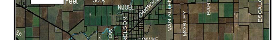
5 July 2015 HTAC STAFF REPORT SUBJECT: RECOMMENDED ACTION: Stanley Road Bridge Scour Project Motion to Approve Recommendation to SJCOG, Inc. to (1) Allow Stanley Road Bridge Scour Project to Participate in the SJMSCP, (2) Allow two Alterations to the Habitat Type Coverage from Agricultural Habitat Land to Multi-Purpose Open Space Habitat Land and Natural (W7) to Natural (W3), and (3) Revision of Incidental Take Minimization Measures for Giant Garter Snake buffer DISCUSSION: SUMMARY: The project applicant, San Joaquin County Public Works, is requesting coverage under the San Joaquin Multi-Species Habitat Conservation and Open Space Plan (SJMSCP) because the site is in the unmapped area of the plan and requires a 404 permit. The project is located on Stanley Road on the west side of Escalon-Bellota Road, and south of State Route Highway 4, north of the City of Escalon in the Central Zone (attachment 1 and 2). RECOMMENDATION: SJCOG, Inc. staff recommends the HTAC make the recommendation to the SJCOG, Inc. Board to (1) allow the project to participate under the SJMSCP to provide biological coverage for project impacts to the habitat types under the federal and state permits, (2) allow an alteration to the habitat type coverage from agricultural habitat land to multi-purpose open space habitat land and Natural (W7) to Natural (W3), and (3) a revision to the Incidental Take Minimization Measures for Giant Garter Snake (GGS) buffer. FISCAL IMPACT: SJCOG, Inc. to be provided mitigation for the project impacts as required under the SJMSCP. If the alteration to the habitat type is approved, SJCOG, Inc. will be provided mitigation for the project impacts as required under the SJMSCP for impacts to 0.80 acres. The impacts would consist of 0.42 acre of Multi-Purpose Open Space (C5), 0.21 acre of Urban (U2) habitat (e.g.
6 $7,281 per acre and $0.00 per acre rather than $14,543 per acre) and 0.17 acre of Natural (W3) habitat impacts at the appropriate rate at disturbance under the Plan. BACKGROUND: The County proposes to improve existing scour protection within the project area. The existing earthen channel of Littlejohn s Creek at the Stanley Road Bridge will be cut to a maximum depth of feet, and then filled with a layer of Caltrans Light Class Rock Slope Protection (RSP), matching both upstream and downstream conditions and channel grade. RSP will be installed on approximately 0.14 acres of the existing earthen channel of Littlejohn s Creek at the bridge. An approximately 0.44 acre Temporary Construction Easement would be used for construction access, temporary cofferdams, in-stream access ramp, and staging. The existing Stanley Road right-of-way (approximately 0.33 acres) would be used for project access. Between 4 and 10 construction is expected to be completed within 28 days. In-stream construction work is not expected to exceed 18 days (attachment 3). In order for the project to construct the Stanley Road Bridge Scour project, the project will impact Giant Garter Snake (GGS) habitat within the suggested 200 foot buffer. As identified in section 5.59 of the plan, HTAC, on a case by case review, can establish a setback and buffer zone to be used by a project in place of the 200 feet suggested. Because construction of portions of the bridge replacement will be placed directly into waterways and within the suggested 200 foot buffer area, the project proponent has requested a reduction in the buffer to a 0 setback. The reduction of this buffer is necessary for the construction of this project. All other ITMM measures for GGS (e.g. construction window between May and October and required survey work) will remain standard. In accordance with the SJMSCP Planned Land Use Map, the project site is located in the unmapped land use area. Because it is not located on a SJMSCP Compensation Map, the project can request an alteration to the SJMSCP vegetation map habitat classification on a case by case review. The project is seeking an alteration to the habitat classification on the SJMSCP vegetation map based on the SJMSCP Section for a clerical change by the JPA to the habitat classification on the project site based on provided aerial photography imagery dated just prior to SJMSCP permit issuance in 2001 on a case-by-case review by the Habitat TAC for recommendation to SJCOG Inc. Board for approval. Based on the habitat classification by the permitting agencies and local jurisdictions prior to issuance of the SJMSCP permits in 2001 through broader review of habitat types in San Joaquin County, the SJMSCP GIS vegetation map habitat layer classifies the project site as Agriculture (C34) and Natural (W7). However; aerial photography (attachment 4) show portions of the land within the project footprint are actually Urban (U2), Multi-Purpose Open Space (C5), and Natural (W3) consisting of an existing road and bridge (U2), open space or ruderal land (C5), and a portion of South Littlejohn s Creek (W3). The original SJMSCP habitat classification for this specific area would be re-classified from 0.63 acres of Agriculture (C34) habitat to 0.21 acres Urban (U2) habitat and 0.42 acres of Multi-Purpose Open Space (C5) habitat and 0.17 acres of Natural (W7) habitat to 0.17 acres of Natural (W3) habitat.
7 The SJMSCP GIS habitat layer classifies the project site as Urban (U2), Multi-Purpose Open Space (C5), and Natural (W3). If allowed to participate in the SJMSCP, the total disturbed area of 0.80 acre will consist of 0.21 acre of Urban (U2), 0.42 acre of Multi-Purpose Open Space (C5) and 0.17 acre of Natural (W3) habitat impacts. The project applicant will be responsible for mitigating for the habitat impacts that is consumed by this project by either paying the appropriate fees at time of ground disturbance or dedicating land in lieu of a fee at appropriate the SJMSCP ratio. Adjacent Vegetation and Land Use Location SJMSCP Vegetation Map Classification Site North South East West Multi-Purpose Open Space (C2), Agriculture (C34), Natural (W7) Multi-Purpose Open Space (C2), Agriculture (C34) Multi-Purpose Open Space (C2), Agriculture (C34) Multi-Purpose Open Space (C2), Agriculture (C34), Natural (W7) Multi-Purpose Open Space (C2), Natural (W7) Habitat Type Category Multi-Purpose Open Space (C2), Agriculture (C34), Natural (W7) Multi-Purpose Open Space (C2), Agriculture (C34) Multi-Purpose Open Space (C2), Agriculture (C34) Multi-Purpose Open Space (C2), Agriculture (C34), Natural (W7) Multi-Purpose Open Space (C2), Natural (W7) Actual Use Of Property Urban (U2), Multi-Purpose Open Space (C5), Natural (W3) Urban (U2), Multi-Purpose Open Space (C2), Agriculture (C34) Multi-Purpose Open Space (C2) Multi-Purpose Open Space (C2), Agriculture (C34), Natural (W3) Multi-Purpose Open Space (C2), Natural (W3) COMMITTEE ACTIONS: Habitat Technical Advisory Committee: Action Required SJCOG, Inc. Board: July 23 rd if recommended ATTACHMENTS: 1. General Location Map 2. Project Location Map 3. Project Site Map 4. Project Site Map Prepared by: Laurel Boyd, Habitat Planner Technician


8 ATTACHMENT 1


9 ATTACHMENT 2

10 ATTACHMENT 3


11 ATTACHMENT 4
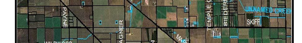
12 July 2015 HTAC STAFF REPORT SUBJECT: RECOMMENDED ACTION: Austin Road Bridge Scour Project Motion to Approve Recommendation to SJCOG, Inc. to (1) Allow Austin Road Bridge Scour Project to Participate in the SJMSCP, (2) Allow two Alterations to the Habitat Type Coverage from Agricultural Habitat Land to Multi-Purpose Open Space Habitat Land, and (3) Revision of Incidental Take Minimization Measures for Giant Garter Snake buffer DISCUSSION: SUMMARY: The project applicant, San Joaquin County Public Works, is requesting coverage under the San Joaquin Multi-Species Habitat Conservation and Open Space Plan (SJMSCP) because portions of the site is in the unmapped area of the plan and requires a 404 permit. The project is located on Austin Road on the east side of State Route Highway 99, and west of Jack Tone Road, Stockton in the Central Zone (attachment 1 and 2). RECOMMENDATION: SJCOG, Inc. staff recommends the HTAC make the recommendation to the SJCOG, Inc. Board to (1) allow the project to participate under the SJMSCP to provide biological coverage for project impacts to the habitat types under the federal and state permits, (2) allow an alteration to the habitat type coverage from agricultural habitat land to multi-purpose open space, (3) and a revision to the Incidental Take Minimization Measures for Giant Garter Snake (GGS) buffer. FISCAL IMPACT: SJCOG, Inc. to be provided mitigation for the project impacts as required under the SJMSCP. If the alteration to the habitat type is approved, SJCOG, Inc. will be provided mitigation for the project impacts as required under the SJMSCP for impacts to 1.10 acres. The impacts would consist of 0.51 acre of Urban (U) habitat on the Stockton Compensation Map, 0.24 acre of Multi- Purpose Open Space (B) habitat, 0.28 acre of Urban (U2) habitat (e.g. $7,281 per acre and $0.00 per acre rather than $14,543 per acre) and 0.07 acre of Natural (W3) habitat at the appropriate rate at disturbance under the Plan.
13 BACKGROUND: The County proposes to develop a uniform channel section supporting Austin Road Bridge with scour countermeasures to prevent channel degradation of South Littlejohn s Creek. Construction will occur with previously disturbed areas of County right-of-way, while staging will require temporary easements on adjacent properties. The proposed project will include: clearing and grubbing along the creek banks; installation of a temporary access ramp and coffer dams, excavation of the existing earthen channel bottom and banks, and placement of rock slope protection with staggered concrete baffles (attachment 3). In order for the project to construct the Austin Road Bridge Scour project, the project will impact Giant Garter Snake (GGS) habitat within the suggested 200 foot buffer. As identified in section 5.59 of the plan, HTAC, on a case by case review, can establish a setback and buffer zone to be used by a project in place of the 200 feet suggested. Because construction of portions of the bridge replacement will be placed directly into waterways and within the suggested 200 foot buffer area, the project proponent has requested a reduction in the buffer to a 0 setback. The reduction of this buffer is necessary for the construction of this project. All other ITMM measures for GGS (e.g. construction window between May and October and required survey work) will remain standard. In accordance with the SJMSCP Planned Land Use Map, the project site is partially located in the unmapped land use area. Because portions of the project are not located on a SJMSCP Compensation Map, the project can request an alteration to the SJMSCP vegetation map habitat classification on a case by case review. The project is seeking an alteration to the habitat classification on the SJMSCP vegetation map based on the SJMSCP Section for a clerical change by the JPA to the habitat classification on the project site based on provided aerial photography imagery dated just prior to SJMSCP permit issuance in 2001 on a case-by-case review by the Habitat TAC for recommendation to SJCOG Inc. Board for approval. Based on the habitat classification by the permitting agencies and local jurisdictions prior to issuance of the SJMSCP permits in 2001 through broader review of habitat types in San Joaquin County, the SJMSCP GIS vegetation map habitat layer classifies the southeast portion of the project site as Agriculture (C34). However; aerial photography (attachment 4) show portions of the land within the project footprint are actually Multi-Purpose Open Space (B) consisting of ruderal habitat land. The original SJMSCP habitat classification for this specific area would be re-classified from 0.52 acres of Agriculture (C34) habitat to 0.24 acres of Multi-Purpose Open Space (B) and 0.28 acres of Urban (U2) habitat.. The SJMSCP GIS habitat layer classifies the project site as Urban (City of Stockton Compensation map and U2), Multi-Purpose Open Space (B), and Natural (W3). If allowed to participate in the SJMSCP, the total disturbed area of 1.10 acres will consist of 0.51 acres of Urban (City of Stockton Compensation Map), 0.28 acres of Urban (U2), 0.24 acres of Multi-Purpose Open Space (B), and 0.07 acres of Natural (W3) habitat impacts. The project
14 applicant will be responsible for mitigating for the habitat impacts that is consumed by this project by either paying the appropriate fees at time of ground disturbance or dedicating land in lieu of a fee at appropriate the SJMSCP ratio. Adjacent Vegetation and Land Use Location SJMSCP Vegetation Map Classification Site Urban (U), Natural (W3), Agriculture (C34) Habitat Type Category Urban (U; Mapped), Natural (W3), Agriculture (C34) Actual Use Of Property Urban (Mapped; U2), Natural (W3), Multi-Purpose Open Space (B) North Agriculture (C34) Agriculture (C34) Agriculture (C34) South Agriculture (C34), Multi-Purpose Open Agriculture (C34), Multi-Purpose Open Multi-Purpose Open Space (B) Space (B) Space (B) East Agriculture (C34), Natural (W3) Agriculture (C34), Natural (W3) Natural (W3), Multi-Purpose Open Space (B) West Urban (Mapped), Multi-Purpose Open Urban (Mapped), Multi-Purpose Open Urban (Mapped), Multi-Purpose Space (B), Natural (W3) Space (B), Natural (W3) Open Space (B), Natural (W3) COMMITTEE ACTIONS: Habitat Technical Advisory Committee: Action Required SJCOG, Inc. Board: July 23 rd if recommended ATTACHMENTS: 1. General Location Map 2. Project Location Map 3. Project Site Map 4. Project Site Map Prepared by: Laurel Boyd, Habitat Planner Technician
15 ATTACHMENT 1

16 ATTACHMENT 2

17 ATTACHMENT 3 ATTACHMENT 4


18
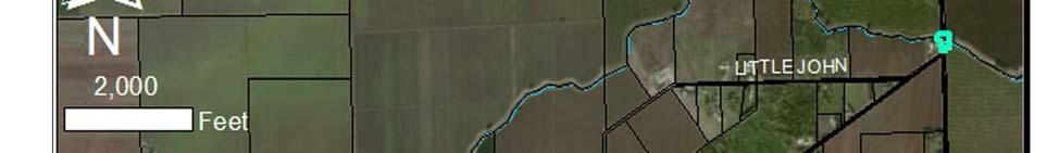
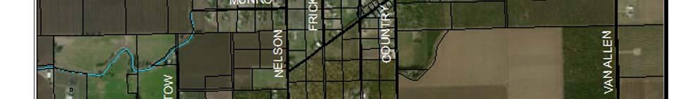
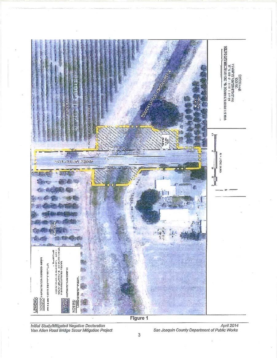
19 July 2015 HTAC STAFF REPORT SUBJECT: RECOMMENDED ACTION: Van Allen Bridge Scour Project Motion to Approve Recommendation to SJCOG, Inc. to (1) Allow Van Allen Bridge Scour Project to Participate in the SJMSCP, (2) Allow two Alterations to the Habitat Type Coverage from Agricultural Habitat Land to Multi-Purpose Open Space and Urban Habitat Land and Natural (W7) to Natural (W3), and (3) Revision of Incidental Take Minimization Measures for Giant Garter Snake buffer DISCUSSION: SUMMARY: The project applicant, San Joaquin County Public Works, is requesting coverage under the San Joaquin Multi-Species Habitat Conservation and Open Space Plan (SJMSCP) because the site is in the unmapped area of the plan and requires a 404 permit. The project is located on Van Allen Road on the west side of Escalon-Bellota Road, and east of Jack Tone Road, Escalon in the Central Zone (attachment 1 and 2). RECOMMENDATION: SJCOG, Inc. staff recommends the HTAC make the recommendation to the SJCOG, Inc. Board to (1) allow the project to participate under the SJMSCP to provide biological coverage for project impacts to the habitat types under the federal and state permits, (2) allow an alteration to the habitat type coverage from agricultural habitat land to multi-purpose open space and urban habitat land and Natural (W7) to Natural (W3), and (3) a revision to the Incidental Take Minimization Measures for Giant Garter Snake (GGS) buffer. FISCAL IMPACT: SJCOG, Inc. to be provided mitigation for the project impacts as required under the SJMSCP. If the alteration to the habitat type is approved, SJCOG, Inc. will be provided mitigation for the project impacts as required under the SJMSCP for impacts of 0.84 acres. The impacts would consist of 0.35 acre of Multi-Purpose Open Space (C5), 0.31 acre of Urban (U2) habitat and 0.18
20 acre of Natural habitat (e.g SJMSCP fees of $7,281 and $0.00 per acre rather than $14,543 per acre) at the appropriate rate at time of disturbance under the Plan. BACKGROUND: The County proposes to develop a uniform channel section supporting Van Allen Road Bridge with scour countermeasures to prevent channel degradation of South Littlejohn s Creek. Construction will occur with previously disturbed areas of County right-of-way, while staging will require temporary easements on adjacent properties. The proposed project will include: clearing and grubbing along the creek banks; installation of a temporary access ramp and coffer dams, or alternative diversion methods, to access the creek channel during construction will the creek is flowing; excavation of the existing earthen channel bottom and banks to an approximate depth of 4.5 feet; placement Rock Slope Protection (RSP) in the excavated channel bottom to conform to the upstream and downstream conditions with staggered concrete baffles to hold the RSP in place; and potential placement of RSP in the form of riprap along the embankment to reduce depths of excavation (attachment 3). In order for the project to construct the Van Allen Bridge Scour project, the project will impact Giant Garter Snake (GGS) habitat within the suggested 200 foot buffer. As identified in section of the plan, HTAC, on a case by case review, can establish a setback and buffer zone to be used by a project in place of the 200 feet suggested. Because construction of portions of the bridge replacement will be placed directly into waterways and within the suggested 200 foot buffer area, the project proponent has requested a reduction in the buffer to a 0 setback. The reduction of this buffer is necessary for the construction of this project. All other ITMM measures for GGS (e.g. construction window between May and October and required survey work) will remain standard. In accordance with the SJMSCP Planned Land Use Map, the project site is located in the unmapped land use area. Because it is not located on a SJMSCP Compensation Map, the project can request an alteration to the SJMSCP vegetation map habitat classification on a case-by-case review. The project is seeking an alteration to the habitat classification on the SJMSCP vegetation map based on the SJMSCP Section for a clerical change by the JPA to the habitat classification on the project site based on provided aerial photography imagery dated just prior to SJMSCP permit issuance in 2001 on a case-by-case review by the Habitat TAC for recommendation to SJCOG Inc. Board for approval. Based on the habitat classification by the permitting agencies and local jurisdictions prior to issuance of the SJMSCP permits in 2001 through broader review of habitat types in San Joaquin County, the SJMSCP GIS vegetation map habitat layer classifies the project site as Agriculture (C34) and Natural (W7). However; aerial photography (attachment 4) show portions of the land within the project footprint are actually Urban (U2), Multi-Purpose Open Space (C5), and Natural (W3) consisting of an existing road and bridge (U2), open space or ruderal land (C5), and a portion of South Littlejohn s Creek (W3). The original SJMSCP habitat classification for this specific area would be re-classified from 0.66 acres of Agriculture (C34) habitat to 0.31 acres Urban (U2) habitat and 0.35 acres of Multi-Purpose Open Space (C5) habitat and 0.18 acres of Natural (W7) habitat to 0.14 acres of Natural (W3) habitat.
21 The SJMSCP GIS habitat layer classifies the project site as Urban (U2), Multi-Purpose Open Space (C5), and Natural (W3). If allowed to participate in the SJMSCP, the total disturbed area of 0.84 acres will consist of 0.31 acres of Urban (U2), 0.35 acres of Multi-Purpose Open Space (C5), and 0.18 acres of Natural (W3) habitat impacts. The project applicant will be responsible for mitigating for the habitat impacts that is consumed by this project by either paying the appropriate fees at time of ground disturbance or dedicating land in lieu of a fee at appropriate the SJMSCP ratio. Adjacent Vegetation and Land Use Location SJMSCP Vegetation Map Classification Habitat Type Category Actual Use Of Property Natural (W7), Agriculture (C34) Urban (U2), Natural (W3), Site Natural (W7), Agriculture (C34) Multi-Purpose Open Space (C5) North Agriculture (C34) Agriculture (C34) Multi-Purpose Open Space (C5) South Agriculture (C34) Agriculture (C34) Agriculture (C34) Agriculture (C34) Agriculture (C34) Natural (W3), Multi-Purpose East Open Space (C5) West Multi-Purpose Open Space (C2) Multi-Purpose Open Space (C2) Urban (U) COMMITTEE ACTIONS: Habitat Technical Advisory Committee: Action Required SJCOG, Inc. Board: July 23 rd if recommended ATTACHMENTS: 1. General Location Map 2. Project Location Map 3. Project Site Map 4. Project Site Map Prepared by: Laurel Boyd, Habitat Planner Technician


22 ATTACHMENT 1


23 ATTACHMENT 2
24 ATTACHMENT 3


25 ATTACHMENT 4
26 July 2015 HTAC STAFF REPORT SUBJECT: RECOMMENDED ACTION: Beecher Road Homesite Project Motion to Approve Recommendation to SJCOG, Inc. Allowing the Beecher Road Homesite Project to Participate in the SJMSCP DISCUSSION: SUMMARY: The project applicant, Dillon & Murphy consultant for the land owner, is requesting coverage under the San Joaquin Multi-Species Habitat Conservation and Open Space Plan (SJMSCP) because the site is in the unmapped area of the plan. The project is located on the east side of Beecher Road, 1,200 feet north of Comstock Road, east of Stockton in the Central Zone (attachment 1 and 2). RECOMMENDATION: SJCOG, Inc. staff recommends the HTAC make the recommendation to the SJCOG, Inc. Board to allow the project to participate under the SJMSCP to provide biological coverage for project impacts to the habitat types under the federal and state permits. FISCAL IMPACT: SJCOG, Inc. to be provided mitigation for the project impacts as required under the SJMSCP. BACKGROUND: The project includes the demolition and construction of a modular homesite of approximately 0.20 acres on a previously subdivided parcel (attachment 3). In accordance with the SJMSCP Planned Land Use Map, the project site is located in the unmapped land use area. According to the SJMSCP, projects located in the unmapped areas of San Joaquin County are not automatically covered activities and require a case-by-case review by the Habitat TAC for recommendation to SJCOG Inc. Board for SJMSCP coverage. The SJMSCP GIS habitat layer classifies the project site as Multi-Purpose Open Space (C2).
27 If allowed to participate in the SJMSCP, the total disturbed area of 0.20 acres will consist of Multi-Purpose Open Space (C2) habitat impacts. The project applicant will be responsible for mitigating for the habitat impacts that is consumed by this project by either paying the appropriate fees at time of ground disturbance or dedicating land in lieu of a fee at appropriate the SJMSCP ratio. Adjacent Vegetation and Land Use Location SJMSCP Vegetation Map Classification Habitat Type Category Actual Use Of Property Site Multi-Purpose Open Space (C2) Multi-Purpose Open Space (C2) Multi-Purpose Open Space (C2) North Multi-Purpose Open Space (C2) Multi-Purpose Open Space (C2) Multi-Purpose Open Space (C2) South Agriculture (C34)/Multi-Purpose Open Agriculture (C34)/Multi-Purpose Open Agriculture (C34)/Multi-Purpose Space (C2) Space (C2) Open Space (C2) East Agriculture (C34) Agriculture (C34) Agriculture (C34) West Multi-Purpose Open Space (C2) Multi-Purpose Open Space (C2) Multi-Purpose Open Space (C2) COMMITTEE ACTIONS: Habitat Technical Advisory Committee: Action Required SJCOG, Inc. Board: July 23 rd if recommended ATTACHMENTS: 1. General Location Map 2. Project Location Map 3. Project Site Map Prepared by: Laurel Boyd, Habitat Planner Tech


28 ATTACHMENT 1


29 ATTACHMENT 2
30 ATTACHMENT 3
31 7/2015 HTAC STAFF REPORT SUBJECT: SJMSCP Financial Analysis Update Services Addendum for HEG RECOMMENDED ACTION: Motion to Recommend Approval by the SJCOG, Inc. Board to 1) Amend the Hausrath Economics Group Contract and 2) Direct SJCOG, Inc. Treasurer to Negotiate and Execute Final Terms DISCUSSION: SUMMARY: The current SJMSCP fee analysis 5-year review began in December 2014 after the contract was awarded to Hausrath Economics Group (HEG) in November 2014 following a Request for Qualifications to provide the services. The services were to assist staff and the HTAC Financial Subcommittee on the SJMSCP Financial Analysis Update which will help evaluate the fee model for the plan. The duties of the consultant and all sub-consultants included in the bid were to assist staff and subcommittee members on establishing any updates, changes or modifications to the existing model with the refinement being minor in nature. The current contract was is $60,000 for the services in the bid with the work to be completed by December During the review of the fee model, SJCOG, Inc. staff and consultants found potential refinements to be considered to the SJMSCP fee model in this update which should be discussed and explored to accurately assess the potential costs of Category B (enhancements) and Category C (land management). In order to thoroughly conduct these activities, a greater amount of time is needed to deconstruct the fee model, compare it to the plan s original documents (biological opinion, financial analysis, and plan) to separate out possible areas of refinement. This in-depth review was not part of the original scope of HEG. However, SJCOG, Inc. staff believes there is value in this approach for the short and long term viability of the habitat plan and fairness to the fee payers. Therefore, an addendum to the original HEG contract is proposed to adjust the overall scope and work costs. The proposed amendment to the HEG contract (attachment 1) is an addition of 3 tasks and a cost of approximately $24,640. BACKGROUND: In December 2014, SJCOG, Inc. staff, legal counsel, consultants and HTAC Financial Sub-committee members began the 5-year review analysis to update the San Joaquin County Multi-Species Habitat Conservation and Open Space Plan (SJMSCP) fee model. While conducting the review work on Category B and Category C components of the overall SJMSCP
32 development fee, SJCOG, Inc. staff and the consultants believe a deeper review and refinement should be explored. This process is going to be more involved for refinement of the fee model than expected and take 2-3 months longer to gaining consensus by stake holder regarding future fees. With an unexpected absence by the federal and state regulatory representative because of workloads, a window of time has opened to allow the deeper review and refinement to take place. The process will require refining two (2) of the three components of the SJMSCP fee model. The work will include the deconstruction of the current fee model Category B and C components, refinement of the habitat categories within the fee model to apply a cost per acre within the habitat plan s original documentation (biological opinion and plan) for consistency and reconstruction of the materials to complete the fee model for use. New requested tasks, not included in the original scope of work, are: Task 1: Review and refine habitat types used in cost analysis - Review Habitat Plan tables, the sources for those tables, and the translation of information in the current model. - Deconstruct the existing fee model for Category B and C fee components by habitat type for refinement of acres for understanding of per acre cost application. - Reconstruct refined fee model for Category B and C fee components and run multiple test scenarios for evaluation purposes to ensure appropriate data included. - Prepare tables and analysis for staff and consultant team review and coordinate with team to refine estimates for use in the updated model. Prepare alternative scenarios for staff review and comment and integrate updated estimates in the cost and fee model. - Prepare various scenarios for the consensus with permitting agencies prior to HTAC Financial Subcommittee with potential revisions and gain final consensus. - Prepare final SJMSCP Financial Model to HTAC/Board with examples of model runs. Task 2: Additional meetings - Assumes up to 4 additional meetings with Financial Subcommittee for deconstruction and reconstruction of the Category B and C components specifically. Task 3: Staff Support - Assumes up to 40 hours of additional staff support as needed for completion of the first model run for SJMSCP fees. RECOMMENDATION: HTAC Financial Subcommittee and SJCOG, Inc. staff recommends HTAC recommend to the SJCOG, Inc. Board approval to amend the Hausrath Economics Group contract under the SJMSCP for economic services for the Financial Analysis Update and authorizes negotiations by the Treasurer to establish the addendum to the contract. FISCAL IMPACT: HEG has submitted an addendum scope and cost of $24,640 to cover the additional work for the financial analysis update. The costs will include further refinement and detailing of the SJMSCP fee model and supporting documents, meetings with the permitting agencies and the final
33 presentation to HTAC and SJCOG, Inc. Board. The fiscal impact of the contract addendum will not exceed $24,640 from the SJMSCP funds. All funding for the financial analysis update services will be provided through habitat fees as a development activity. COMMITTEE ACTION: 1. HTAC Financial Subcommittee Recommended for Approval by HTAC 2. HTAC Recommendation for Approval to SJCOG, Inc. Board 3. SJCOG, Inc. Board Action Required if Recommended ATTACHMENTS: 1. HEG Scope/Costs Addendum June 3, 2015 Prepared by: Steven Mayo, Program Manager
34 ATTACHMENT 1
SAN JOAQUIN COUNTY MULTI-SPECIES HABITAT CONSERVATION AND OPEN SPACE PLAN HABITAT TECHNICAL ADVISORY COMMITTEE MEETING &
 SAN JOAQUIN COUNTY MULTI-SPECIES HABITAT CONSERVATION AND OPEN SPACE PLAN HABITAT TECHNICAL ADVISORY COMMITTEE MEETING & HTAC FINANCIAL SUB-COMMITTEE MEETING San Joaquin Council of Governments Regional
5. Public Hearing for Dutra Ranch Preserve Acquisition Action. 6. Public Hearing for Jaques Wing Levee Preserve Acquisition Action
 SAN JOAQUIN COUNTY MULTI-SPECIES HABITAT CONSERVATION AND OPEN SPACE PLAN HABITAT TECHNICAL ADVISORY COMMITTEE MEETING & HTAC FINANCIAL SUB-COMMITTEE MEETING San Joaquin Council of Governments Regional
San Joaquin Council of Governments Regional Center Building 555 E. Weber Avenue Stockton, CA 95202
 SAN JOAQUIN COUNTY MULTI-SPECIES HABITAT CONSERVATION AND OPEN SPACE PLAN HABITAT TECHNICAL ADVISORY COMMITTEE MEETING San Joaquin Council of Governments Regional Center Building 555 E. Weber Avenue Stockton,
San Joaquin Multi-Species Habitat Conservation and Open Space Plan. Habitat Technical Advisory Committee. San Joaquin Council of Governments
 SAN JOAQUIN COUNTY MULTI-SPEC CIES HABITAT CONSERVATION AND OPEN SPACE PLAN HABITATT TECHNICAL ADVISORY COMMITTEE MEETING & HTAC FINANCIAL SUB-COMMITTEE MEETING San Joaquin Council of Governments Regional
2. Public Comments. Participation in members of the. locations. utilized. Action. Discussion/Action. City of Tracy 333 Civic Center Tracy, CA 95376
 SAN JOAQUIN COUNTY MULTI-SPECIESS HABITAT CONSERVATION AND OPEN SPACEE PLAN HABITAT TECHNICAL ADVISORY COMMITTEE MEETING & HTAC FINANCIAL SUB-COMMITTEE MEETING San Joaquin Council of Governments Regional
Chapter SWAINSON S HAWK IMPACT MITIGATION FEES
 The Swainson s Hawk ordinance can also be viewed online at: http://qcode.us/codes/sacramentocounty/ Once at the website, click on Title 16 BUILDINGS AND CONSTRUCTION, then Chapter 16.130 SWAINSON S HAWK
3. Adopt the Preliminary Use and Management Plan for the property granted to the District.
 R-13-119 Meeting 13-34 December 11, 2013 AGENDA ITEM AGENDA ITEM 8 Approval of an Agreement to Exchange Real Property Interests with Santa Clara County (County) Roads & Airports concerning County property
CHAPTER 8. IMPLEMENTATION COSTS AND FUNDING SOURCES
 0 0 0 CHAPTER. IMPLEMENTATION COSTS AND FUNDING SOURCES. INTRODUCTION The Endangered Species Act (ESA) requires that habitat conservation plans specify the funding that will be available to implement actions
Chapter HABITAT CONSERVATION PLAN / NATURAL COMMUNITY CONSERVATION PLAN IMPLEMENTATION ORDINANCE
 Chapter 15.108 HABITAT CONSERVATION PLAN / NATURAL COMMUNITY CONSERVATION PLAN IMPLEMENTATION ORDINANCE Sections: 15.108.010 Purpose. 15.108.020 Definitions. 15.108.030 Applicability 15.108.040 Responsibility
NOTICE OF A REGULAR MEETING
 NOTICE OF A REGULAR MEETING Pursuant to Section 54954.2 of the Government Code of the State of California, a Regular meeting of the City of Tracy Planning Commission is hereby called for: Date/Time: Wednesday,
Claudia Stuart, Williamson Act Program Manager and Nick Hernandez, Planning Intern
 Land Conservation (Williamson) Act Advisory Committee STAFF REPORT September 15, 2014 Prepared by: Claudia Stuart, Williamson Act Program Manager and Nick Hernandez, Planning Intern Subject: Discussion:
City of Palo Alto (ID # 4882) City Council Staff Report
 City Council Staff Report") City of Palo Alto (ID # 4882) City Council Staff Report Report Type: Consent Calendar Meeting Date: 12/15/2014 Summary Title: Easements for San Francisquito Creek Joint Powers Authority Initial Flood Protection
City of Palo Alto (ID # 4882) City Council Staff Report Report Type: Consent Calendar Meeting Date: 12/15/2014 Summary Title: Easements for San Francisquito Creek Joint Powers Authority Initial Flood Protection
Draft Continuing Authorities Program Section 1135 Detailed Project Report and Integrated Environmental Assessment
 Appendix G Real Estate Shorty s Island / Meander Reach Ecosystem Restoration Kootenai River, Idaho Draft Continuing Authorities Program Section 1135 Detailed Project Report and Integrated Environmental
REPORT TO PLANNING AND DESIGN COMMISSION City of Sacramento
 REPORT TO PLANNING AND DESIGN COMMISSION City of Sacramento 915 I Street, Sacramento, CA 95814-2671 www.cityofsacramento.org 9 PUBLIC HEARING December 10, 2015 To: Members of the Planning and Design Commission
Implementation Tools for Local Government
 Information Note #5: Implementation Tools for Local Government This Information Note is a guide only. It is not a substitute for the federal Fisheries Act, the provincial Riparian Areas Regulation, or
South Sacramento Habitat Conservation Plan Nexus Study
 South Sacramento Habitat Conservation Plan Nexus Study Prepared for: SSHCP Plan Partners Prepared by: Economic & Planning Systems, Inc. April 5, 2018 EPS #161005 Table of Contents 1. INTRODUCTION AND MITIGATION
REQUEST FOR PLANNING COMMISSION ACTION PLANNING COMMISSION MEETING DATE: NOVEMEBER 22, 2016
 REQUEST FOR PLANNING COMMISSION ACTION V.B. EBBE VIDERIKSEN, APPLICANT (PROJECT PLANNER: SIJIFREDO M. FERNANDEZ JR.) Consideration of a one-year Time Extension for Tentative Tract No. 18560 to subdivide
Central Lathrop Specific Plan
 Addendum to the Draft Environmental Impact Report for the Central Lathrop Specific Plan SCH# 2003072132 Prepared for City of Lathrop Prepared by December 2005 Addendum to the Draft Environmental Impact
Napa County Planning Commission Board Agenda Letter
 Agenda Date: 9/20/2017 Agenda Placement: 8C Napa County Planning Commission Board Agenda Letter TO: FROM: Napa County Planning Commission Charlene Gallina for David Morrison - Director Planning, Building
CITY OF FORT COLLINS NATURAL AREAS AND CONSERVED LANDS EASEMENT POLICY
 CITY OF FORT COLLINS NATURAL AREAS AND CONSERVED LANDS EASEMENT POLICY Adopted January 3, 2012 PURPOSE: The purpose of the policy statement is to clarify the policies and procedures of the City of Fort
***** Subchapter A. GENERAL PROVISIONS ***** PERMIT APPLICATIONS
 105.11. Permit requirements. 105.12. Waiver of permit requirements. Title 25 Environmental Protection Part I. Department of Environmental Protection Subpart C. Protection of Natural Resources Article I.
Introduction to INRMP Implementation Options
 El Dorado County Integrated Natural Resources Management Plan Introduction to INRMP Implementation Options 1 Our approach to the options evaluation is based on the INRMP components as they are currently
APPLICATION PROCESSING. CHECK WITH STAFF - Development Services Staff will explain the requirements and procedures to you.
 PLANNED DEVELOPMENT ZONE 1810 E. HAZELTON AVENUE, STOCKTON CA 95205 BUSINESS PHONE: (209) 468-3121 Business Hours: 8:00 a.m. to 5:00 p.m. (Monday through Friday) STEP 1 STEP 2 FEE FORM DEED SERVICES APPLICATION
ARLINGTON COUNTY, VIRGINIA. County Board Agenda Item Meeting of June 17, 2017
 ARLINGTON COUNTY, VIRGINIA County Board Agenda Item Meeting of June 17, 2017 DATE: June 9, 2017 SUBJECT: Request to authorize advertisement of public hearings by the Planning Commission and County Board
APPLICATION PROCESSING
 MAJOR SUBDIVISION 1810 E. HAZELTON AVENUE, STOCKTON CA 95205 BUSINESS PHONE: (209) 468-3121 BUSINESS HOURS: 8:00 A.M. TO 5:00 P.M..(Monday through Friday) APPLICATION PROCESSING STEPS STEP 1 STEP 2 CHECK
Application Procedures for Easements or Rights of Way on City of Fort Collins Natural Areas and Conserved Lands March 2012
 Application Procedures for Easements or Rights of Way on City of Fort Collins Natural Areas and Conserved Lands March 2012 IMPORTANT NOTE: This document was created to accompany the City of Fort Collins
Marin County Agricultural Land Conservation Program March 1, 2014
 Marin County Agricultural Land Conservation Program March 1, 2014 I. Purpose of this Document This document describes the Marin County Agricultural Land Conservation Program (County Program). The Marin
BACKGROUND There are 23 flood control structures in the Upper Brushy Creek Water Control and Improvement District (District). See attached map.
. See attached map.") BACKGROUND There are 23 flood control structures in the Upper Brushy Creek Water Control and Improvement District (District). See attached map. The U.S Department of Agriculture - Natural Resources Conservation
BACKGROUND There are 23 flood control structures in the Upper Brushy Creek Water Control and Improvement District (District). See attached map. The U.S Department of Agriculture - Natural Resources Conservation
MITIGATION POLICY FOR DISTRICT-PROTECTED LANDS
 MITIGATION POLICY FOR DISTRICT-PROTECTED LANDS Approved by the District Board of Directors on July 18, 2017 The following Mitigation Policy is intended to inform the evaluation of environmental mitigation-related
Yolo Habitat Conservancy County of Yolo City of Davis City of Winters City of West Sacramento City of Woodland University of California, Davis
 Yolo Habitat Conservancy County of Yolo City of Davis City of Winters City of West Sacramento City of Woodland University of California, Davis Science & Technical Advisory Committee (STAC) Operational
MEMORANDUM. Current Development Fees
 MEMORANDUM To: Edmund Sullivan, Santa Clara Valley Habitat Agency From: Robert D. Spencer, Urban Economics Date: February 28, 2018 Subject: FY 2018-19 Habitat Agency Development s Automatic Inflation Adjustment
CITY OF ALBERT LEA PLANNING COMMISSION ADVISORY BOARD
 CITY OF ALBERT LEA PLANNING COMMISSION ADVISORY BOARD 9/1/2015, 5:30 p.m. City Council Chambers AGENDA A. CALL TO ORDER AND ROLL CALL B. APPROVAL OF THE AGENDA C. APPROVAL OF MINUTES 1. PC Minutes from
AGENDA ITEM 3. R Meeting May 14, 2014 AGENDA ITEM
 R-14-75 Meeting 14-12 May 14, 2014 AGENDA ITEM AGENDA ITEM 3 Approval of Grant of Access Easement and Quitclaim Deed between James F. Wickett et al. (San Mateo County Assessor s Parcel Numbers 081-120-060
Stockton Economic Stimulus Plan (SESP) David Kwong Director of Community Development
 David Kwong Director of Community Development") Economic Stimulus Plan (SESP) David Kwong Director of Community Development November 3, 2015 Introduction On October 13, 2015, the City Council conducted a Study Session on the Economic Stimulus Plan.
Economic Stimulus Plan (SESP) David Kwong Director of Community Development November 3, 2015 Introduction On October 13, 2015, the City Council conducted a Study Session on the Economic Stimulus Plan.
APPENDIX "B" STANISLAUS COUNTY FARMLAND MITIGATION PROGRAM GUIDELINES
 APPENDIX "B" STANISLAUS COUNTY FARMLAND MITIGATION PROGRAM GUIDELINES 7-35 Appendix "B" Stanislaus County Purpose and Intent: The purpose of the Farmland Mitigation Program (FMP) is to aid in mitigating
San Joaquin County Grand Jury. Getting Rid of Stuff - Improving Disposal of City and County Surplus Public Assets Case No.
 San Joaquin County Grand Jury Getting Rid of Stuff - Improving Disposal of City and County Surplus Public Assets 2012-2013 Case No. 0312 Summary Cities and counties are authorized to purchase capital assets
Federal Mandates and Willing Sellers: Real Estate Acquisition for the Missouri River Recovery Program
 Federal Mandates and Willing Sellers: Real Estate Acquisition for the Missouri River Recovery Program Brad Thompson, Chief, Civil Works Branch U.S. Corps of Engineers, Omaha District US Army Corps of Engineers
Georgia Conservation Tax Credit Program Frequently Asked Questions
 Georgia Conservation Tax Credit Program Frequently Asked Questions What are the minimum requirements for eligibility under the Georgia Conservation Tax Credit Program (GCTCP)? Individual and corporate
CONDITIONAL USE PERMIT Application Packet
 CONDITIONAL USE PERMIT Application Packet Community Development Department 1020 East Pioneer Road, Draper, UT 84020 (801) 576-6539 Fax (801) 576-6526 Dear Applicant, This application packet has been developed
Easement Program Guidelines for Water Resources and Stream Work
 Easement Program Guidelines for Water Resources and Stream Work The following guidelines are established by the Easement Committee to create standards for reviewing requests by landowners to conduct stream
Board of Supervisors' Agenda Items
 A. Roll Call B. Closed Session COUNTY OF SAN DIEGO BOARD OF SUPERVISORS REGULAR MEETING MEETING AGENDA WEDNESDAY, SEPTEMBER 14, 2016, 9:00 A.M. BOARD OF SUPERVISORS NORTH CHAMBER 1600 PACIFIC HIGHWAY,
Texas Land Trust Conference March 6, 2015
 Texas Land Trust Conference March 6, 2015 James D. Bradbury James D. Bradbury, PLLC Austin Fort Worth An Overview Unique area of law where the government can take private property Protected by the US Constitution
BWSR MN Public Drainage Manual Broad Users Outreach Workshop John Kolb, Attorney Lead Writer Chapter 4. MPDM Chapter 4: Viewing and Appraising
 BWSR MN Public Drainage Manual Broad Users Outreach Workshop John Kolb, Attorney Lead Writer Chapter 4 MPDM Chapter 4: Viewing and Appraising Chapter 4 Subcommittee Members 2 Sherry Enzler, MN DNR Bob
FEE The staff will let you know the current cost of filing an application. Make checks payable to the San Joaquin County Treasurer.
 VARIANCE 1810 E. HAZELTON AVENUE, STOCKTON CA 95205 BUSINESS PHONE: (209) 468-3121 Business Hours: 8:00 a.m. to 5:00 p.m. (Monday through Friday) STEP 1 STEP 2 APPLICATION PROCESSING STEPS CHECK WITH STAFF
Community Development Department Planning Division 1600 First Street + P.O. Box 660 Napa, CA Napa (707)
") Community Development Department Planning Division 1600 First Street + P.O. Box 660 Napa, CA 94559-0660 Napa (707) 257-9530 PLANNING COMMISSION STAFF REPORT JUNE 16, 2016 AGENDA ITEM # 6.B. 16-0056-EXT;
Community Development Department Planning Division 1600 First Street + P.O. Box 660 Napa, CA 94559-0660 Napa (707) 257-9530 PLANNING COMMISSION STAFF REPORT JUNE 16, 2016 AGENDA ITEM # 6.B. 16-0056-EXT;
Committee of Adjustment Agenda. Meeting Date: Monday January 9, 2017 Woodstock City Hall, Council Chambers Regular Session: 7:00 PM
 Committee of Adjustment Agenda Meeting Date: Monday January 9, 2017 Place: Woodstock City Hall, Council Chambers Regular Session: 7:00 PM Chair: Tom Rock 1. Declaration of Conflict Of Interest 2. Approval
RESOLUTION NO. B. The proposed amendment would not be detrimental to the public interest, health, safety, convenience, or welfare of the City; and
 RESOLUTION NO. RESOLUTION OF THE PLANNING COMMISSION OF THE CITY OF SANTA ROSA RECOMMENDING TO CITY COUNCIL REZONING TO MODIFY THE EXISTING POLICY STATEMENT AND ADOPT THE BAY VILLAGE HOMES DEVELOPMENT
MARK TWAIN LAKE MASTER PLAN CLARENCE CANNON DAM AND MARK TWAIN LAKE MONROE CITY, MISSOURI
 MARK TWAIN LAKE MASTER PLAN CLARENCE CANNON DAM AND MARK TWAIN LAKE MONROE CITY, MISSOURI CHAPTER 4 LAND ALLOCATION, LAND CLASSIFICATION, WATER SURFACE, AND EASEMENT LANDS This Master Plan is a land use
SECTION 6 SUBAREA PLAN IMPLEMENTATION POLICIES
 SECTION 6 SUBAREA PLAN IMPLEMENTATION POLICIES This section describes subarea plan implementation actions to be taken by the City of Escondido. These actions are specific to the city and are supplemental
OPEN-SPACE CONVERSION REQUEST
 OPEN-SPACE CONVERSION REQUEST Applicant: Board Meeting: February 9, 2017 Landowner: Normandy Capital, LLC VOF Easement: BAT-03678 Table of Contents: Cover Page 1 Table of Contents 2 Application Overview
IMPLEMENTING AGREEMENT. for the EAST CONTRA COSTA COUNTY HABITAT CONSERVATION PLAN/ NATURAL COMMUNITY CONSERVATION PLAN.
 IMPLEMENTING AGREEMENT for the EAST CONTRA COSTA COUNTY HABITAT CONSERVATION PLAN/ NATURAL COMMUNITY CONSERVATION PLAN by and between EAST CONTRA COSTA COUNTY HABITAT CONSERVANCY, COUNTY OF CONTRA COSTA,
East Contra Costa County Habitat Conservation Plan / Natural Community Conservation Plan (HCP/NCCP) HCP/NCCP Application Process.
 HCP/NCCP Application Process.") East Contra Costa County Habitat Conservation Plan / Natural Community Conservation Plan (HCP/NCCP) HCP/NCCP Application Process January 9, 2008 John Kopchik (Contra Costa County) and David Zippin (Jones
East Contra Costa County Habitat Conservation Plan / Natural Community Conservation Plan (HCP/NCCP) HCP/NCCP Application Process January 9, 2008 John Kopchik (Contra Costa County) and David Zippin (Jones
City of Stockton. Legislation Text AUTHORIZE ACQUISITION OF REAL PROPERTY LOCATED AT 501 AND 509 WEST WEBER AVENUE
 City of Stockton Legislation Text File #: 17-3966, Version: 1 AUTHORIZE ACQUISITION OF REAL PROPERTY LOCATED AT 501 AND 509 WEST WEBER AVENUE RECOMMENDATION It is recommended that the City Council adopt
FRESNO COG AG AD-HOC COMMITTEE REPORT TTC / PAC FRIDAY, JANUARY 15, 2016
 FRESNO COG AG AD-HOC COMMITTEE REPORT TTC / PAC FRIDAY, JANUARY 15, 2016 COMMITTEE CHARGE As identified by the Fresno COG Policy Board, the charge of the Committee is to identify potential policies and
PLANNING COMMISSION AGENDA REGULAR MEETING OF APRIL 14, 2004, 9:00 A.M M STREET, BOARD ROOM, THIRD FLOOR, MERCED, CALIFORNIA
 PLANNING AND COMMUNITY DEVELOPMENT DEPARTMENT William Nicholson Director 2222 M Street Merced, CA 95340 (209) 385-7654 (209) 726-1710 Fax www.co.merced.ca.us PLANNING COMMISSION AGENDA REGULAR MEETING
After taking public testimony, staff recommends the City Council take the following course of action:
 City Council Agenda May 5, 2015 Public Hearings Agenda Item No. B.04 Reviewed by City Mgr s office: /KLM Memo to: From: Manteca City Council Erika E. Durrer, Senior Planner Date: April 22, 2015 Subject:
APPLICATION PROCESSING STEPS
 LOT LINE ADJUSTMENT 1810 E. HAZELTON AVENUE, STOCKTON CA 95205 BUSINESS PHONE: (209) 468-3121 Business Hours: 8:00 a.m. to 5:00 p.m. (Monday through Friday) APPLICATION PROCESSING STEPS STEP 1 CHECK WITH
IRS FORM 8283 SUPPLEMENTAL STATEMENT DONATION OF CONSERVATION EASEMENT
 Name(s) shown on income tax return Identifying Number Robert T. Landowner 021-34-1234 Susan B. Landowner 083-23-5555 IRS FORM 8283 SUPPLEMENTAL STATEMENT DONATION OF CONSERVATION EASEMENT On November 12,
Right-of-Way Acquisition and
 Request for Proposals On Call Right-of-Way Acquisition and Appraisal Services Requested by: CityofElCentro Department of Public Works 307 W. Brighton Avenue El Centra, Ca. 92243 Phone: (760) 337-4505 Fax:(760)337-3172
Purpose: Regulations:
 Administrative Procedures for the Designation and Refinement Of Chesapeake Bay Preservation Area Boundaries Guidance on the Chesapeake Bay Preservation Area Designation and Management Regulations September,
Mammoth Lakes Town Council Agenda Action Sheet. Council Meeting Date: August 17, 2016 Date Prepared: August 8, 2016
 Agenda Item# FileNo. Mammoth Lakes Town Council Agenda Action Sheet Council Meeting Date: August 17, 2016 Date Prepared: August 8, 2016 Prepared by: Title: Agenda: Ruth Traxier, Associate Planner Consider
OFFICE OF REAL ESTATE
 OFFICE OF REAL ESTATE DATE: October 25, 2017 TO: FROM: RE: Users of the Real Estate Manual Wayne Pace, Manager Acquisition Unit Changes and Updates to the Real Estate Manual The only current and accurate
411 Acres, Two Coastal California Ranches, Estero Bay - Morro Bay, CA
 411 Acres, Two Coastal California Ranches, Estero Bay - Morro Bay, CA FOR SALE Price Reduction Contact: Steve McCarty DRE#: 00977930 Steve Davis DRE#: 01843738 Property Features: Two Prime Coastal Ranch
Article 5. Environmentally Sensitive Areas
 Article 5. Environmentally Sensitive Areas This Article establishes standards and regulations governing environmental constraints. These regulations are intended to encourage preservation of lands designated
ORDINANCE NO The Board of Supervisors of the County of San Joaquin ordains as follows:
 ORDINANCE NO. 4308 AN ORDINANCE ADDING CHAPTER 9-1080 OF DIVISION 10 OF TITLE 9 OF THE ORDINANCE CODE OF SAN JOAQUIN COUNTY PERTAINING TO AGRICULTURAL MITIGATION. The Board of Supervisors of the County
MINERAL COUNTY PLANNING STAFF FINDINGS OF FACT Proposed Elk Run at St. Regis. February 12, 2017
 MINERAL COUNTY PLANNING STAFF FINDINGS OF FACT Proposed The proposed is a five-lot subdivision and is located approximately one mile east of St. Regis on Old Highway 10 East. The property is located in
Hank's Exchange Road Bridge Replacement Project
 Hank's Exchange Road Bridge Replacement Project Public Information Meeting, Wednesday, May 12, 2014 Gold Oak School Presented By: El Dorado County Community Development Agency, Transportation Division
MONTGOMERY COUNTY PLANNING DEPARTMENT THE MARYLAND-NATIONAL CAPITAL PARK AND PLANNING COMMISSION
 MONTGOMERY COUNTY PLANNING DEPARTMENT THE MARYLAND-NATIONAL CAPITAL PARK AND PLANNING COMMISSION MCPB Item No. Hearing Date: 10/8/15 Howard Hughes Medical Institute, Limited Amendment of the Preliminary
Applicant: ONTARIO INC. JOE NUOSCI. MARK MCCONVILLE Humphries Planning Group Inc.
 File: A043/15 Item # 20 Ward #1 Applicant: 2109179 ONTARIO INC. JOE NUOSCI Address: Agent: 3501 King-Vaughan Road, Woodbridge MARK MCCONVILLE Humphries Planning Group Inc. Adjournment Status: Notes: Comments/Conditions:
APPLICATION PROCESSING STEPS STEP 1 CHECK WITH STAFF
 APPLICATION PROCESSING STEPS STEP 1 CHECK WITH STAFF - Development Services Staff will explain the requirements and procedures to you. However, before filing an application with the Community Development
FORM Seven (7) copies of the completed application information forms (attached) which all owners must sign.
 copies of the completed application information forms (attached) which all owners must sign.") WILLIAMSON ACT CONTRACT CANCELLATION SAN JOAQUIN COUNTY COMMUNITY DEVELOPMENT DEPARTMENT 1810 E. HAZELTON AVENUE, STOCKTON CA 95205 BUSINESS PHONE: (209) 468-3121 Business Hours: 8:00 a.m. to 5:00 p.m.
WILLIAMSON ACT CONTRACT CANCELLATION SAN JOAQUIN COUNTY COMMUNITY DEVELOPMENT DEPARTMENT 1810 E. HAZELTON AVENUE, STOCKTON CA 95205 BUSINESS PHONE: (209) 468-3121 Business Hours: 8:00 a.m. to 5:00 p.m.
COUNTY OF SACRAMENTO CALIFORNIA ZONING ADMINISTRATOR REPORT
 COUNTY OF SACRAMENTO CALIFORNIA ZONING ADMINISTRATOR REPORT Control No.: PLNP2012-00058 Type: VAZ TO: FROM: ZONING ADMINISTRATOR DEPARTMENT OF COMMUNITY DEVELOPMENT CONTACT: Rebecca Boschee, Planner, 874-3104;
Residential Project Convenience Facilities
 Standards for Specific Land Uses 35.42.220 E. Findings. The review authority shall approve a Land Use Permit in compliance with Subsection 35.82.110.E (Findings required for approval) or a Conditional
TransNet Environmental Mitigation Program: Land Acquisition and Restoration Process and Criteria
 TransNet Environmental Mitigation Program: Land Acquisition and Restoration Process and Criteria On September 26, 2008, the San Diego Association of Governments Board of Directors (BOD) approved the attached
Notice of Continuance Land Classified as Current Use or Forest Land Chapter and Revised Code of Washington
 When Recorded Return to: Cowlitz County Assessor s Office Attn: Forest Land / Current Use Dept 207 N 4 th Avenue Kelso WA 98626 Notice of Continuance Land Classified as Current Use or Forest Land Chapter
A Guide to the Municipal Planning Process in Saskatchewan
 A Guide to the Municipal Planning Process in Saskatchewan A look at the municipal development permit and the subdivision approval process in Saskatchewan May 2008 Prepared By: Community Planning Branch
CHAPTER 8. IMPLEMENTATION COSTS AND FUNDING SOURCES
 Working Draft Content Subject to Change Implementation Costs and Funding Sources Chapter 1 1 1 1 1 1 1 1 0 1 0 1 CHAPTER. IMPLEMENTATION COSTS AND FUNDING SOURCES Table of Contents Page.1 Introduction...
Town of Cary, North Carolina Rezoning Staff Report 14-REZ-31 Cary Park PDD Amendment (Waterford II) Town Council Meeting January 15, 2015
 Town Council Meeting January 15, 2015") Town of Cary, North Carolina Rezoning Staff Report 14-REZ-31 Cary Park PDD Amendment (Waterford II) Town Council Meeting January 15, 2015 REQUEST To amend the Town of Cary Official Zoning Map by amending
Town of Cary, North Carolina Rezoning Staff Report 14-REZ-31 Cary Park PDD Amendment (Waterford II) Town Council Meeting January 15, 2015 REQUEST To amend the Town of Cary Official Zoning Map by amending
Land Use Application
 Land Use Application Check all permits you are applying for in the boxes provided. Submit this application form, the applicable materials listed in the corresponding permit application packet(s) and application
Chapter 10 Local Protection Measures
 The DPC fully supports the protection of private property rights and the DPC will work to ensure that there will be no negative impacts stemming from NHA activities on private property, should the designation
DEPARTMENT OF THE ARMY OFFICE OF THE CHIEF OF ENGINEERS WASHINGTON, D.C
 DEPARTMENT OF THE ARMY OFFICE OF THE CHIEF OF ENGINEERS WASHINGTON, D.C. 20314-1000 REPLY TO ATTENTION OF: CECW-PM (10-1-7a) THE SECRETARY OF THE ARMY 1. I submit for transmission to Congress my report
ORDINANCE NO. 875 (AS AMENDED THROUGH 875
 ORDINANCE NO. 875 (AS AMENDED THROUGH 875.1) AN ORDINANCE OF THE COUNTY OF RIVERSIDE TO ESTABLISH A LOCAL DEVELOPMENT MITIGATION FEE FOR FUNDING THE PRESERVATION OF NATURAL ECOSYSTEMS IN ACCORDANCE WITH
EXHIBIT A ENVIRONMENTAL COVENANT AND ACCESS AGREEMENT
 ENVIRONMENTAL COVENANT AND ACCESS AGREEMENT AFTER RECORDING RETURN TO: Laura Wishik, Esq. Director, Environmental Protection Section P. O. Box 94769 Seattle, WA 98124-4769 GRANTOR AND OWNER: City of Seattle
APPENDIX 2 PROCEDURES AND SUPPLEMENTARY INFORMATION
 APPENDIX 2 PROCEDURES AND SUPPLEMENTARY INFORMATION APPENDIX 2 - PROCEDURES AND SUPPLEMENTARY INFORMATION 1. Building Code Act 1.1 General The Building Code Act provides the enabling authority for Councils
CITY AND COUNTY OF HONOLULU DEPARTMENT OF BUDGET & FISCAL SERVICES ADMINISTRATIVE GUIDELINES FOR COMMUNITY FACILITIES DISTRICTS
 Working Draft of May 14, 2004 Working Draft of August 11, 2004 Working Draft of September 8, 2004 CITY AND COUNTY OF HONOLULU DEPARTMENT OF BUDGET & FISCAL SERVICES ADMINISTRATIVE GUIDELINES FOR COMMUNITY
RESOLUTION NO. R To Acquire Real Property Interests Required for the Downtown Redmond Link Extension
 RESOLUTION NO. R2018-07 To Acquire Real Property Interests Required for the Downtown Redmond Link Extension MEETING: DATE: TYPE OF ACTION: STAFF CONTACT: Capital Committee Board PROPOSED ACTION 03/08/2018
Land Management Plan Fargo-Moorhead (FM) Area Flood Risk Reduction Project Version 1
 Area Flood Risk Reduction Project Version 1") Land Management Plan Fargo-Moorhead (FM) Area Flood Risk Reduction Project Version 1 Prepared for Fargo-Moorhead Area Flood Diversion Board of Authority July 12, 2012 REV 1 Contents Section Page Acronyms
Land Management Plan Fargo-Moorhead (FM) Area Flood Risk Reduction Project Version 1 Prepared for Fargo-Moorhead Area Flood Diversion Board of Authority July 12, 2012 REV 1 Contents Section Page Acronyms
STAFF REPORT. Permit Number: Porter. Kitsap County Board of Commissioners; Kitsap County Planning Commission
 STAFF REPORT Permit Number: 15 00461 Porter DATE: November 9, 2015 TO: FROM: Kitsap County Board of Commissioners; Kitsap County Planning Commission Katrina Knutson, AICP, Senior Planner, DCD and Jeff
SECTION IV. Recommended Motion: Staff recommends the following motion (with modifications and additions following discussion):
:") ST. MARY S COUNTY GOVERNMENT DEPARTMENT OF LAND USE AND GROWTH MANAGEMENT William B. Hunt, AICP, Director Kathleen Easley, Deputy Director COMMISSIONERS OF ST. MARY S COUNTY James R. Guy, President Michael
ST. MARY S COUNTY GOVERNMENT DEPARTMENT OF LAND USE AND GROWTH MANAGEMENT William B. Hunt, AICP, Director Kathleen Easley, Deputy Director COMMISSIONERS OF ST. MARY S COUNTY James R. Guy, President Michael
Staff Planner Carolyn A.K. Smith
 Applicant Property Owner, Pamela K. & Steven A. Gray Public Hearing April 13, 2016 City Council Election District Princess Anne Agenda Item 8 Request Modification of Proffers (Modification to the proffer
Condominium Unit Requirements.
 ARTICLE 19 CONDOMINIUM REGULATIONS Section 19.01 Purpose. The purpose of this Article is to regulate projects that divide real property under a contractual arrangement known as a condominium. New and conversion
Protecting Water in the Stream: Colorado s Instream Flow Program Sustaining Colorado Watersheds
 Protecting Water in the Stream: Colorado s Instream Flow Program 2011 Sustaining Colorado Watersheds Avon, Colorado October 5, 2011 Colorado Water Conservation Board Carl Trick Eric Wilkinson North Platte
Conservation Design Subdivisions
 Conservation Design Subdivisions An excerpt from the Rules and Regulations Governing Division of Land in Sheridan County, Wyoming, November 5, 2010 Sheridan County Public Works Department 224 S. Main Street
Proposed Management Plan for SCE&G Future Development Property December 2007
 Proposed Management Plan for SCE&G Future Development Property December 2007 BASELINE 1984 License Classifications Future Development Forest and Game Management Easement Project Works Recreation (Current
October 1, 2011 thru December 31, 2011 Performance Report
 Grantee: San Joaquin County, CA Grant: B-08-UN-06-0005 October 1, 2011 thru December 31, 2011 Performance Report 1 Grant Number: B-08-UN-06-0005 Grantee Name: San Joaquin County, CA Grant Amount: $9,030,385.00
EL DORADO COUNTY PLANNING AND BUILDING DEPARTMENT ZONING ADMINISTRATOR STAFF REPORT VARIANCE
 EL DORADO COUNTY PLANNING AND BUILDING DEPARTMENT ZONING ADMINISTRATOR STAFF REPORT Agenda of: April 18,2018 Item No.: Staff: 5.a. Emma Carrico VARIANCE FILE NUMBER: APPLICANT: REQUEST: LOCATION: V17-0003/La
MONTEREY COUNTY STANDARD SUBDIVISION COMMITTEE
 MONTEREY COUNTY STANDARD SUBDIVISION COMMITTEE Meeting: May 11, 2006 Agenda Item: 1 Project Description: Standard Subdivision Amendment of recorded Markham Ranch Subdivision Map to relocate building envelope
Approved: May 9, 2018 CITY OF ARDEN HILLS, MINNESOTA PLANNING COMMISSION WEDNESDAY, APRIL 4, :30 P.M. - ARDEN HILLS CITY HALL
 Approved: May 9, 2018 CITY OF ARDEN HILLS, MINNESOTA PLANNING COMMISSION WEDNESDAY, APRIL 4, 2018 6:30 P.M. - ARDEN HILLS CITY HALL CALL TO ORDER/ROLL CALL Pursuant to due call and notice thereof, Chair
Grand Mesa, Uncompahgre and Gunnison National Forests Region 2, USDA Forest Service
 Decision Memo Taylor River Land Exchange Under the General Exchange Act of March 20, 1922 as Amended, The Federal Land Policy and Management Act of 1976 as Amended and the Federal Land Exchange Facilitation
Lessard Sams Outdoor Heritage Council
 Lessard Sams Outdoor Heritage Council MEMO: Agenda Item # 10 DATE: December 11, 2014 SUBJECT: PRESENTER: 2015 Legislative Appropriation Recommendation Bill Heather Koop, LSOHC staff Background: On October