ARLINGTON COUNTY, VIRGINIA. County Board Agenda Item Meeting of June 17, 2017
|
|
|
- Jason Bond
- 5 years ago
- Views:
Transcription

1 ARLINGTON COUNTY, VIRGINIA County Board Agenda Item Meeting of June 17, 2017 DATE: June 9, 2017 SUBJECT: Request to authorize advertisement of public hearings by the Planning Commission and County Board on the Chesapeake Bay Preservation Area Map, an element of the County's Comprehensive Plan, and the Chesapeake Bay Preservation Ordinance (Chapter 61 of the County Code). C. M. RECOMMENDATION: Adopt the attached Resolution to authorize advertisement of public hearings by the Planning Commission on July 5, 2017, and by the County Board on July 15, 2017 to consider the adoption of an updated Chesapeake Bay Preservation Area Map and removal of the Chesapeake Bay Preservation Ordinance from the County s Comprehensive Plan. ISSUES: State statute requires local governments to establish and maintain an accurate Chesapeake Bay Preservation Area ( CBPA ) map ( Map ) as a component of their Comprehensive Plan (9VAC ). An accurate Map is required for staff to fairly review development project proposals. Revisions to the Map will remove Resource Protection Area ( RPA ) designations from 280 parcels, but will result in new RPA designations on 196 properties. Property owners who receive new Resource Protection Area designations as a result of the CBPA map update may be concerned about limitations on development rights and potentially decreased property values. SUMMARY: The Chesapeake Bay Preservation Area Map was last updated in Data collection for the Stormwater Master Plan (2014) and the Natural Resource Management Plan (2010) has yielded more accurate and thorough geographic information about the County s water resources. An update to the Map is required to ensure that the County can fulfill its regulatory responsibilities, review development projects fairly, protect water quality and provide accurate information to its residents and stakeholders. Adoption of the updated Map will remove RPA designation from 280 parcels, and will decrease the total number of parcels with RPA in the County from 1,523 to 1,439 parcels. However, 196 new properties will be designated with RPA as result of the update. The additional permitting and mitigation requested for RPA projects can add to the time and expense of a project. Typically, however, planned RPA projects are able to County Manager: ##### County Attorney: ***** Staff: Christin Jolicoeur, OSEM-DES Aileen Winquist, OSEM-DES 42.
2 move forward, and include measures to protect water quality. Analysis of sales data by the Department of Real Estate Assessments during the past 10 years for more than 300 single-family properties designated with RPA did not indicate that the designation negatively impacts the sale of a property. Additionally, the Chesapeake Bay Preservation Ordinance is a regulatory document and as such is not a required Comprehensive Plan element. The Chesapeake Bay Preservation Plan, within the Comprehensive Plan, will continue to guide policy decisions. BACKGROUND: The Virginia General Assembly adopted the Chesapeake Bay Preservation Act in 1988 to improve water quality in the Chesapeake Bay and other waters in the State. The Act and associated Chesapeake Bay Preservation Area Designation and Management Regulations require local governments along the tidal portion of the Bay and its major tributaries to adopt ordinance and Comprehensive Plan elements to protect environmentally-sensitive areas adjacent to streams and tidal shorelines, and to maintain a Chesapeake Bay Preservation Area map depicting the location and extent of such lands. Arlington County adopted its Chesapeake Bay Preservation Ordinance ( Ordinance ) and an official Chesapeake Bay Preservation Area Map in May 1992 as elements of the Comprehensive Plan. In 2001, the County adopted the Chesapeake Bay Preservation Plan as a component of its Comprehensive Plan. The adopted Map has not been revised since The Map depicts lands identified as Chesapeake Bay Preservation Areas by the County Board under the Ordinance. These lands include both RPAs and Resource Management Areas ( RMAs ). RMAs include land types that, if improperly used or developed, have a potential for causing significant water quality degradation or for diminishing the functional value of the RPA. All of Arlington County, outside of RPAs, has been designated as RMA. Arlington s Map is functionally a map of RPAs and is often referred to as the RPA map. Resource Protection Areas: The County s Ordinance identifies RPAs as: tidal wetlands; non-tidal wetlands connected by surface flow and contiguous to tidal wetlands or water bodies with perennial (year-round) flow; tidal shores; and the 100-foot buffer adjacent to these features as well as along both sides of perennial streams. The other lands provision of the state regulation (9VAC ) gives local governments the authority to designate additional environmentally-sensitive lands with intrinsic water quality value as RPA. With the 2003 amendment of the Ordinance, the County Board designated the following additional other lands as RPA: all natural and man-made stream channels mapped in the most recent version of the County s GIS system (includes streams without year-round flow); a 100-foot buffer along both sides of such channels; adjacent 25 percent or greater slopes; and - 2 -
3 adjacent 15 percent or greater slopes when necessary to protect the integrity of the RPA buffer. Currently, this last category of protected lands applies only to the Potomac Palisades area of the County from Chain Bridge to the County boundary, affecting 17 properties in the Arlingwood Civic Association. The County s Ordinance establishes a link between local land use decision making and water quality protection. Within RPAs, building and landscaping activities are regulated to protect water quality and water resources. Some activities within the RPA, including gardening, and repair and maintenance of existing landscape and building areas, can occur at a property owner s discretion. On properties where RPA is designated, building projects, such as the replacement or expansion of an existing home, that increase stormwater runoff and/or could negatively impact the RPA require additional review during permitting. Property owners may be required to adjust their development plan or mitigate water quality impacts and protect or enhance existing RPA vegetation. Certain projects may require an exception from the Chesapeake Bay Ordinance Review Committee (CBORC) before they can be permitted. DISCUSSION: Map Revision: Existing published stream maps, supplemented with limited field assessment, formed the basis for the current Map. Since 2003, the County has used field assessment to refine its natural resource and storm infrastructure mapping. The Natural Heritage Resource Inventory completed in support of the 2010 Natural Resource Management Plan generated revised maps of Arlington s stream and wetland resources. The County mapped and assessed local streams to compile the stream inventory incorporated in the Stormwater Master Plan (2014). Storm sewer mapping completed for that Plan also yielded new and more accurate data about the County s storm sewer infrastructure. Infrastructure and drainage projects undertaken by the County on private property can produce new information about stream and wetland resources on private land. As a result, significant updates to the County s Geographic Information System (GIS) stream map have occurred over the past decade as data collected from these various sources has been incorporated. The County s Ordinance includes two key provisions that, applied together, underscore the necessity of the proposed Map update: 1) RPAs include all natural stream channels and man-made open stream channels as depicted on the most recent storm sewer map layer of the County's geographic information system [GIS].; and, 2) Where RPA boundaries on the adopted CBPA map differ from boundaries as determined from the text of this chapter, the text shall govern. This provision anticipates minor inaccuracies in the County s stream and storm system mapping, and eliminates the need to continuously revise the Map. However, under this provision protected areas can exist on a property, and property owners may be subject to code requirements, in the absence of an accurate adopted Map. These two provisions mean that any update of the GIS map has the potential to create new RPAs
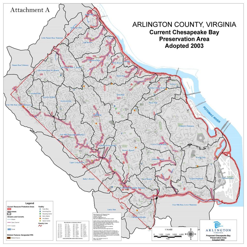
4 A revision to the current Arlington County adopted Map (Attachment A) is necessary at this time to ensure consistency with County Code and State requirements and to ensure fair and equitable customer service to property owners and the development community. Currently, inaccuracies in the adopted 2003 Map are significant enough to create situations where property owners may not be able to determine that their property is affected by the RPA designation. Alternatively, the Map may depict RPA where it does not currently exist. In the absence of an accurate Map, staff implementing the Ordinance have interpreted the Map in favor of the property owner when RPA designations have not been clearly identified. Arlington County s Chesapeake Bay program is periodically reviewed by the Virginia Department of Environmental Quality for compliance with the Chesapeake Bay Preservation Act. Maintaining a current Map consistent with Ordinance language is an element of having a compliant program, as is appropriate and consistent enforcement of the local ordinance. Table 1 presents the quantitative impact of the proposed map revision on Arlington County properties. RPA is currently designated on 1,523 parcels of these, 1,225 are zoned for singlefamily or townhouse development. The Map revision will remove RPA from 280 parcels, but will also designate new RPA on 196 parcels. The net impact of the revision is a decrease in both the number of parcels and number of RPCs impacted by the RPA designation. The extent of the RPA on a parcel may also change as a result of the proposed Map revision. Table 1: Impact of proposed Map revision. Adopted CBPA Map Proposed CBPA Map RPA Removed No. Parcels with RPA designation No. SFH/TH 1 parcels with RPA designation No. of SFH/TH parcels with main structure in RPA No. of SFH/TH parcel - RPA within 15 feet of the main structure No. of RPCs with RPA designation n/a n/a RPA Added n/a n/a 430 Additionally, the proposed CBPA map revision (Attachment B) would result in the RPA designation being added to three park properties (and removed from one) and one school property (and removed from one). 1 Single-family home/townhome - 4 -
5 If the proposed Map is adopted by the County Board, it would become effective on January 1, This provides property owners affected by a new RPA designation with time to submit planned projects for permitting. Permit applications received prior to the effective date would not be subject to the review for water quality impacts required by the Ordinance for projects with an RPA designation. An on-line map overlaying the current and proposed RPA is available to illustrate where RPA will be removed and added ( Community Process: Staff initially notified County property owners regarding the proposed CBPA map update via postal letter in June The County also held three public meetings, two in July 2016 and a third in May 2017, to provide residents with the opportunity to learn more about the Map revision. Additionally, staff provided updates to citizen and development groups, including the Arlington County Civic Federation (January 2017), the Arlington County Inspection Services Division Contractors/Expeditors Meeting (April 2017), the Urban Forestry Commission (April 2017) and the Environment and Energy Conservation Commission (June 2016 and May 2017). If authorized by the Board, the Planning Commission will hold a public hearing on the map update on July 5, Owners of properties receiving a new RPA designation have expressed several concerns related to the CBPA map update. Their concerns focus on: the quality of the resources to be protected likely development restrictions on their properties, and loss of property value. These issues and concerns are highlighted in more detail below. Quality of Resources to Be Protected: The stream inventory conducted for the 2014 Stormwater Master Plan identified a number of previously unmapped stream segments, primarily ephemeral and intermittent hillside drainages located on steep slopes. Because these channels do not exhibit consistent flow, residents may consider these streams to be eroded ditches and may not agree that a particular stream warrants the limitations the RPA designation places on their property. However, the County s intermittent and ephemeral streams are tributaries of perennial streams, making them an integral component of the County stream network. Their setting on steep slopes with high erosion potential makes them extremely sensitive to impacts from development. Additionally, because they are alternately wet and dry, they foster unique chemical processes that remove pollutants and provide critical wildlife habitat. These non-perennial water resources especially with their adjacent forest cover are the type of environmentally-sensitive areas the other lands authority is delegated to local governments to protect. Overall, most of the streams designated with RPA in the County are estimated to have perennial flow, and most RPA designations can be attributed to a proximity to perennial streams. In total approximately 32 miles of stream are designated with RPA in the County, and 92 percent are known to be perennial streams
6 Development Constraints: The RPA designation does not eliminate the opportunity for property owners to pursue desired development or redevelopment. RPA development proposals are reviewed relative to the existing RPA condition. Structures and uses existing on a parcel when RPA is designated are grandfathered and can be maintained, repaired or replaced in-kind without regulatory review. Redevelopment proposals such as a home addition or the tear down and replacement of an existing residence must be permitted and may require a CBORC exception and/or mitigation for potential water quality impacts. Almost all planned RPA projects are permitted after review, and frequently projects incorporate measures to protect water quality. Mitigation requests usually include the addition of native vegetation, the removal of invasive plant or additional stormwater management requirements. A key provision of the County Ordinance protects the development potential of undeveloped lots designated with RPA. The additional permitting for RPA projects can add to the time and expense of a project. The fee for a Chesapeake Bay water quality impact review is scaled based on the size of the project. Projects disturbing fewer than 2,500 square feet are not charged a fee. The fee is $525 for singlefamily home projects disturbing 2,500 square feet or more and $1,575 for projects disturbing 5,000 square feet or more in the RPA requiring an exception. Review typically occurs concurrent with other required permitting. Projects requiring an exception may take longer to permit. Mitigation requested to offset potential water quality concerns can also add costs. These costs range from zero to several thousand dollars depending on the mitigation requested. Property owners may also choose to amend the desired scope of a project or modify the footprint or orientation of a proposed development to avoid an exception hearing, reduce mitigation requirements or to streamline permit review. Overall, however, staff strive to implement RPA requirements in a way that is practical, fair and defensible from both the regulatory and community perspective. Impact of The RPA Designation On Property Value: At the request of the Department of Environmental Services, the Department of Real Estate Assessments completed a study of RPA sales data in February That study examined transactions during the past ten years for more than 300 single family properties designated with RPA. The study compared assessed value to sales price, and determined that for RPA properties this relationship is comparable to this relationship County-wide. Sales data for properties with the RPA designation do not indicate that the designation negatively impacts the sale of a property. This study did not examine factors such as time on market or the relationship between the asking and the sales price. Conversations with agents and buyers suggest that a buyer s perspective affects whether the RPA designation is viewed as a positive (because it preserves existing natural areas and open space) or a negative (because it constrains redevelopment). Comprehensive Plan Implications: The Chesapeake Bay element of the County s Comprehensive Plan currently consists of: the Chesapeake Bay Preservation Ordinance the 2003 Chesapeake Bay Preservation Area map; and the Chesapeake Bay Preservation Plan - 6 -
7 State regulations (9VAC ) require the County to develop and maintain a Chesapeake Bay comprehensive plan component consisting of: relevant data; analysis and policy discussions; a Chesapeake Bay Preservation Areas map; and an implementation plan. The Virginia Department of Environmental Quality confirms that localities are not required to include Chesapeake Bay ordinances in their Comprehensive Plan under the Chesapeake Bay Preservation Act or Chesapeake Bay Preservation Area Designation and Management Regulations as these are regulatory documents and therefore not pertinent in the County s primary policy document, the Comprehensive Plan. The County s Chesapeake Bay Preservation Plan, adopted in 2001, provides the required data on Arlington s water resources and existing and potential water-related development and includes the required analysis and policy discussion and implementation plan. Should any future amendments be considered for the Preservation Plan, those would continue to be reviewed by the Planning Commission and adopted by the County Board. Removal of the Ordinance from the Comprehensive Plan will not affect its regulatory authority. The Ordinance will remain a component of County Code (Chapter 61). If the County Board approves the removal of the Ordinance from the Comprehensive Plan, staff will take additional steps to update/revise other elements of the Comprehensive Plan that currently indicate the Ordinance as part of the Comprehensive Plan. Going forward, amendments to the Ordinance would be reviewed by the County Board. Conclusion: More accurate data on the location and condition of our streams and wetlands collected in support of the Stormwater Master Plan and Natural Resources Management Plan has resulted in substantive revisions to the County s GIS stream map. As a result, an update to the County s Chesapeake Bay Preservation Area Map is required to meet state regulatory requirements and accurately depict the location of Resource Protection Areas established under the Chesapeake Bay Preservation Ordinance. Staff recommends that the County Board adopt the attached resolution (Attachment C) to authorize advertisement of public hearings by the Planning Commission on July 5, 2017, and by the County Board on July 15, 2017, to consider adoption of the proposed update of the Chesapeake Bay Preservation Area Map and removal of the Chesapeake Bay Preservation Ordinance from the Arlington County Comprehensive Plan. FISCAL IMPACT: None. The primary fiscal impact is staff to respond to inquiries regarding the Ordinance, and to review and approve permit applications for RPA impacts. The number of properties with an RPA designation will decrease slightly as a result of the Map update. Currently, fewer than 30 permit applications are reviewed annually. The impact of the Map update on the number of annual permit applications is difficult to predict as it cannot be known which properties will develop and when. However, this number is not anticipated to increase. Therefore, no additional funding for staff is required. Revenue from permit fee collection may decrease slightly, but this decrease is expected to be negligible
8
9
10 Attachment C RESOLUTION TO AUTHORIZE ADVERTISEMENT OF PUBLIC HEARINGS BY THE PLANNING COMMISSION AND BY THE COUNTY BOARD TO CONSIDER ADOPTION OF THE UPDATED CHESAPEAKE BAY PRESERVATION AREAS MAP AND REMOVAL OF THE CHESAPEAKE BAY PRESERVATION ORDINANCE FROM THE COMPREHENSIVE PLAN The County Board of Arlington County hereby resolves to authorize the advertisement of a public hearing by the Planning Commission on July 5, 2017 and by the County Board on July 15, 2017 to consider adoption of the updated Chesapeake Bay Preservation Areas Map and removal of the Chesapeake Bay Preservation Ordinance from the Comprehensive Plan.
Request to Advertise: Chesapeake Bay Preservation Area (CBPA) Map Update. June 20, 2017
 Map Update. June 20, 2017") Request to Advertise: Chesapeake Bay Preservation Area (CBPA) Map Update June 20, 2017 Outline Context Past County Board actions Why update the CBPA Map? What and Why - Resource Protection Areas Property
Request to Advertise: Chesapeake Bay Preservation Area (CBPA) Map Update June 20, 2017 Outline Context Past County Board actions Why update the CBPA Map? What and Why - Resource Protection Areas Property
Chesapeake Bay Preservation Area (CBPA) Map Update. Presentation to the County Board July 15, 2017
 Map Update. Presentation to the County Board July 15, 2017") Chesapeake Bay Preservation Area (CBPA) Map Update Presentation to the County Board July 15, 2017 Chesapeake Bay Program Comprehensive Plan Chesapeake Bay Preservation Ordinance (1992) (Chapter 61, Arlington
Chesapeake Bay Preservation Area (CBPA) Map Update Presentation to the County Board July 15, 2017 Chesapeake Bay Program Comprehensive Plan Chesapeake Bay Preservation Ordinance (1992) (Chapter 61, Arlington
Resource Protection Area Map Update - Frequently Asked Questions
 DEPARTMENT OF ENVIRONMENTAL SERVICES Office of Sustainability and Environmental Management 2100 Clarendon Boulevard, Suite 705, Arlington, VA 22201 TEL 703-228-4488 FAX 703-228-7134 TTY 703-228-4611 www.arlingtonva.us
CHAPTER 6 CHESAPEAKE BAY PRESERVATION AREAS AND STREAM PROTECTION AREAS
 CHAPTER 6 CHESAPEAKE BAY PRESERVATION AREAS AND STREAM PROTECTION AREAS 6.1 INTRODUCTION Virginia s Chesapeake Bay Preservation Area (CBPA) Designation and Management Regulations (9VAC10-20 et seq.) require
Purpose: Regulations:
 Administrative Procedures for the Designation and Refinement Of Chesapeake Bay Preservation Area Boundaries Guidance on the Chesapeake Bay Preservation Area Designation and Management Regulations September,
ARLINGTON COUNTY CODE. Chapter 61 CHESAPEAKE BAY PRESERVATION ORDINANCE*
 Chapter 61 CHESAPEAKE BAY PRESERVATION ORDINANCE* * Editors Note: Ord. No. 03-1, adopted Feb. 8, 2003, amended Ch. 61, in its entirety, to read as herein set out in 61-1-61-19. 61-1. Title 61-2. Purpose
MIDWAY CITY Municipal Code
 MIDWAY CITY Municipal Code TITLE 9 ANNEXATION CHAPTER 9.01 PURPOSE CHAPTER 9.02 GENERAL REQUIREMENTS CHAPTER 9.03 PROPERTY OWNER INITIATION OF ANNEXATION CHAPTER 9.04 PROCEDURES FOR CONSIDERATION OF PETITION
ARTICLE IX. CHESAPEAKE BAY PRESERVATION AREA DISTRICT
 ARTICLE IX. CHESAPEAKE BAY PRESERVATION AREA DISTRICT Sec. 26-512. - Findings. Ordinance Adopted 12/9/03 Amended 05/27/14 The Chesapeake Bay and its tributaries ("the Bay") are one of the most important
CHESAPEAKE BAY PRESERVATION AREA EXCEPTION APPLICATION INSTRUCTIONS
 City of Chesapeake Department of Planning Post Office Box 15225 Chesapeake, Virginia 23328-5225 (757) 382-6176 FAX (757) 382-6406 CHESAPEAKE BAY PRESERVATION AREA EXCEPTION APPLICATION INSTRUCTIONS PURPOSE
ARTICLE VII: CHARLES CITY COUNTY SEPTIC SYSTEM CONTROL ORDINANCE
 ARTICLE VII: CHARLES CITY COUNTY SEPTIC SYSTEM CONTROL ORDINANCE Adopted: July 1, 1994 CHARLES CITY COUNTY SEPTIC SYSTEM CONTROL ORDINANCE Section 1.0 Title This Ordinance shall be known as the Charles
Conservation Easement Stewardship
 Conservation Easements are effective tools to preserve significant natural, historical or cultural resources. Conservation Easement Stewardship Level of Service Standards March 2013 The mission of the
Applicant s Agent Lisa Murphy, Esq. Staff Planner PJ Scully. Lot Recordation 12/01/1972 Map Book 94, Page 33 GPIN
 Property Owner and Applicant Address 3925 Shore Drive Public Hearing September 24, 2018 City Council District Bayside Agenda Item 6 Variance Request Encroachment into the Resource Protection Area (RPA)
CHARLES CITY COUNTY SITE PLAN ORDINANCE. This Ordinance shall be known as the Charles City County Site Plan Ordinance.
 CHARLES CITY COUNTY SITE PLAN ORDINANCE Section 1. Title This Ordinance shall be known as the Charles City County Site Plan Ordinance. Section 2. Authority. This Ordinance is enacted pursuant to the authority
Chapter 26 of the Chesapeake City Code be amended to add Article X thereto, entitled Chesapeake Bay Preservation Area District, as follows:
 Ordinance Adopted 12/9/03 Amended 7/26/05 AN ORDINANCE AMENDING CHAPTER 26 OF THE CHESAPEAKE CITY CODE, TO ADD ARTICLE X THERETO, ENTITLED CHESAPEAKE BAY PRESERVATION AREA DISTRICT TO CREATE THE CHESAPEAKE
RPA Map Update Public Meeting Questions and Answers
 DEPARTMENT OF ENVIRONMENTAL SERVICES Office of Sustainability and Environmental Management 2100 Clarendon Boulevard, Suite 705, Arlington, VA 22201 TEL 703-228-4488 FAX 703-228-7134 TTY 703-228-4611 www.arlingtonva.us
Ensures that all perennial streams and connected wetland are identified and protected for projects that disturb more than 2,500 sf of land.
 Page 1 of 22 A. MAP ISSUES 1. How should the Resource Protection Area (RPA) be mapped? The draft Chesapeake Bay Preservation Area Map ( the Map ) is general in nature and is not intended to depict the
APPENDIX 7 SPECIAL NOTES FOR PLATS AND CONSTRUCTION PLANS
 APPENDIX 7 SPECIAL NOTES FOR PLATS AND CONSTRUCTION PLANS EASEMENT AND DRAINAGE STATEMENT TO BE PLACED ON PLANS AND ALL SUBDIVISION PLATS REQUIRING SOIL DRAINAGE MANAGEMENT PLANS The easements designated
CHAPTER 5 ENVIRONMENTAL COMPLIANCE PLAN REQUIREMENTS
 CHAPTER 5 5.1 INTRODUCTION As previously discussed, land-disturbing activities in Henrico County are subject to the requirements of numerous environmental programs as a result of mandates imposed by various
STAFF REPORT. Permit Number: Porter. Kitsap County Board of Commissioners; Kitsap County Planning Commission
 STAFF REPORT Permit Number: 15 00461 Porter DATE: November 9, 2015 TO: FROM: Kitsap County Board of Commissioners; Kitsap County Planning Commission Katrina Knutson, AICP, Senior Planner, DCD and Jeff
Easement Program Guidelines for Water Resources and Stream Work
 Easement Program Guidelines for Water Resources and Stream Work The following guidelines are established by the Easement Committee to create standards for reviewing requests by landowners to conduct stream
Staff Report. Planning Commission Public Hearing: October 17, 2007 Staff Recommendation: Denial
 COUNTY OF PRINCE WILLIAM 5 County Complex Court, Prince William, Virginia 22192-9201 PLANNING (703) 792-6830 Metro 631-1703, Ext. 6830 FAX (703) 792-4401 OFFICE Internet www.pwcgov.org Stephen K. Griffin,
FRESHWATER WETLANDS PROTECTION IN NEW JERSEY Tools for Municipal Action
 FRESHWATER WETLANDS PROTECTION IN NEW JERSEY Tools for Municipal Action The Freshwater Wetlands Protection Act INTENT OF FRESHWATER WETLANDS LAW The New Jersey legislature passed the Freshwater Wetlands
GWINNETT COUNTY CSO CONSERVATION SUBDIVISION OVERLAY DISTRICT REQUIREMENTS
 GWINNETT COUNTY CSO CONSERVATION SUBDIVISION OVERLAY DISTRICT REQUIREMENTS Section 1316. CSO Conservation Subdivision Overlay District. 1. Purposes. The purposes of this overlay district are as follows:
Major Subdivision Application Packet. Revised June 2018
 Major Subdivision Application Packet Revised June 2018 Caroline County Department of Planning and Community Development 233 West Broaddus Avenue Bowling Green, VA 22427 www.co.caroline.va.us Phone: 804-633-4303
Implementation Guidance for The Sustainable Growth and Agricultural Preservation Act of 2012 Senate Bill 236
 Implementation Guidance for The Sustainable Growth and Agricultural Preservation Act of 2012 Senate Bill 236 May 22, 2012 Version 1.0 Table of Contents 1. Executive Summary... 1 1.1 Bill Highlights...
SPECIFIC RESPONSES TO AREA COMMISSION OPPOSITION :
 SPECIFIC RESPONSES TO AREA COMMISSION OPPOSITION 3-14-19: Area Commission reasons for opposition in black APPLICANT S RESPONSE IN RED. The comprehensive planning and design of stream restoration efforts
St. Mary s County Comprehensive Zoning Ordinance Article 4. OVERLAY AND FLOATING ZONES
 0 0 0 0 ARTICLE. OVERLAY DISTRICTS AND FLOATING ZONES CHAPTER 0 OVERLAY DISTRICTS, FLOATING ZONES: PURPOSE, STANDARDS, PERMITTED USES Sections: 0. Purpose of the Chesapeake Bay Critical Area Overlay. 0.
Alternatives September 25, ALTERNATIVES. No Action Alternative
 9.0 ALTERNATIVES No Action Alternative The proposed action, one of rezoning some 24 acres of land, will not in and of itself result in any direct change to existing conditions in the project area. Any
Chesapeake Bay Preservation Act Work Program - Stakeholder Issues Matrix with Staff Recommendations - January 4, 2011
 - - A. MAP ISSUES 1. How should the Resource Protection Area (RPA) be mapped? The draft Chesapeake Bay Preservation Area Map ( the Map ) is general in nature and is not intended to depict the specific
A. Maintenance. All legally established, nonconforming structures can be maintained (e.g., painting and repairs);
;") Chapter 24.50 NONCONFORMING USES, STRUCTURES AND LOTS Sections: 24.50.010 Nonconforming uses, structures, and lots Purpose. 24.50.020 Nonconforming uses, structures, and lots Alteration or expansion of
Chapter 24.50 NONCONFORMING USES, STRUCTURES AND LOTS Sections: 24.50.010 Nonconforming uses, structures, and lots Purpose. 24.50.020 Nonconforming uses, structures, and lots Alteration or expansion of
TOWN OF PELHAM, NEW HAMPSHIRE
 TOWN OF PELHAM, NEW HAMPSHIRE BUILDOUT ANALYSIS Prepared for the PELHAM CONSERVATION COMMISSION with the assistance of the NASHUA REGIONAL PLANNING COMMISSION TABLE OF CONTENTS I. INTRODUCTION...1 II.
O-I (Office-Institutional) and AG-1(Agricultural)
 and AG-1(Agricultural)") PROPERTY INFORMATION ADDRESS 3503 and 3505 Bethany Bend DISTRICT, LAND LOTS 2/1 973 and 974 OVERLAY DISTRICT State Route 9 PETITION NUMBERS EXISTING ZONING O-I (Office-Institutional) and AG-1(Agricultural)
PROPERTY INFORMATION ADDRESS 3503 and 3505 Bethany Bend DISTRICT, LAND LOTS 2/1 973 and 974 OVERLAY DISTRICT State Route 9 PETITION NUMBERS EXISTING ZONING O-I (Office-Institutional) and AG-1(Agricultural)
IRS FORM 8283 SUPPLEMENTAL STATEMENT DONATION OF CONSERVATION EASEMENT
 Name(s) shown on income tax return Identifying Number Robert T. Landowner 021-34-1234 Susan B. Landowner 083-23-5555 IRS FORM 8283 SUPPLEMENTAL STATEMENT DONATION OF CONSERVATION EASEMENT On November 12,
Comprehensive Plan /24/01
 IV The is a central component of the Comprehensive Plan. It is an extension of the general goals and policies of the community, as well as a reflection of previous development decisions and the physical
Updated - A Report on the County of Arlington s Existing and Possible Urban Tree Canopy
 Updated - A Report on the County of Arlington s Existing and Possible Urban Tree Canopy Key Terms UTC: Urban tree canopy (UTC) is the layer of leaves, branches, and stems of trees that cover the ground
Implementation Guidance. for. The Sustainable Growth and Agricultural Preservation Act of Senate Bill 236
 Implementation Guidance for The Sustainable Growth and Agricultural Preservation Act of 2012 Senate Bill 236 August 1, 2012 Version 2.0 Table of Contents 1. Executive Summary... 1 1.1 Bill Highlights...
THE BUILDING PERMIT PROCESS FOR SINGLE-FAMILY DWELLINGS REVISED MAY 2006
 DEPARTMENT OF PLANNING AND ZONING Division of Inspections & Permits CUSTOMER ASSISTANCE GUIDE Visit us on the Web at: www.co.cal.md.us THE BUILDING PERMIT PROCESS FOR SINGLE-FAMILY DWELLINGS REVISED MAY
ARTICLE III: DENSITY AND INTENSITY
 ARTICLE III: DENSITY AND INTENSITY Section 18.301: Purpose The purpose of this Article is to indicate the maximum permitted density (for residential projects) and maximum permitted intensity (for nonresidential
Shawnee Landing TIF Project. City of Shawnee, Kansas. Need For Assistance Analysis
 Shawnee Landing TIF Project City of Shawnee, Kansas Need For Assistance Analysis December 17, 2014 Table of Contents 1 EXECUTIVE SUMMARY... 1 2 PURPOSE... 2 3 THE PROJECT... 3 4 ASSISTANCE REQUEST... 7
Planning Department Oconee County, Georgia STAFF REPORT
 Planning Department Oconee County, Georgia STAFF REPORT REZONE CASE #: 7332 DATE: November 28, 2017 STAFF REPORT BY: Gabriel Quintas, Planner APPLICANT NAME: Smith Planning Group PROPERTY OWNER: John Hadden
PLANNED UNIT DEVELOPMENT & SUBDIVISION STAFF REPORT Date: April 18, 2019
 PLANNED UNIT DEVELOPMENT & SUBDIVISION STAFF REPORT Date: April 18, 2019 DEVELOPMENT NAME SUBDIVISION NAME Springhill Village Subdivision Springhill Village Subdivision LOCATION 4350, 4354, 4356, 4358,
***** Subchapter A. GENERAL PROVISIONS ***** PERMIT APPLICATIONS
 105.11. Permit requirements. 105.12. Waiver of permit requirements. Title 25 Environmental Protection Part I. Department of Environmental Protection Subpart C. Protection of Natural Resources Article I.
Affordable Housing Plan
 Affordable Housing Plan CORDOVA HILLS SPECIAL PLANNING AREA 1 Proposed Project Conwy LLC is the master developer ( Master Developer ) of that certain real property in the County of Sacramento ( County
Summary Report of the Stakeholder Process
 Loudoun County, Virginia Summary Report of the Stakeholder Process 12-30-10 Prepared by Milton Herd, AICP Facilitator Contents of this Summary Report 1. Assignment Given to the Stakeholders Group... page
The Ranches Sketch Plan
 The Ranches Sketch Plan APPLICATION: RURAL LAND USE PROCESS (AKA CLUSTER DEVELOPMENT) HEARING DATES: Planning Commission: 12 July 2017 at 6:30 pm Board of County Commissioners: TBD APPLICANT: REQUEST:
LAKE OF THE WOODS COUNTY WETLAND CONSERVATION ORDINANCE OF 2002
 Ordinance # LAKE OF THE WOODS COUNTY WETLAND CONSERVATION ORDINANCE OF 2002 ARTICLE 1 TITLE AND PURPOSE Section 1.1. Title This Ordinance shall be known, cited and referred to as the Lake of the Woods
ADUs and You! Common types of ADUs include mother-in-law suite, garage apartments and finished basements.
 ADUs and You! Accessory Dwelling Units Town of Lyons Accessory Dwelling Units (ADUs) are a form of housing that can be an important tool for diversifying and increasing the local housing stock. Lyons lost
INDIAN RIVER COUNTY, FLORIDA. The Honorable Members of the Planning and Zoning Commission DEPARTMENT HEAD CONCURRENCE
 Public Hearing Legislative INDIAN RIVER COUNTY, FLORIDA M E M O R A N D U M TO: The Honorable Members of the Planning and Zoning Commission DEPARTMENT HEAD CONCURRENCE Robert M. Keating, AICP; Community
Comprehensive Plan Amendment #PLN , Reserve at Cannon Branch (Coles Magisterial District)
") COUNTY OF PRINCE WILLIAM 5 County Complex Court, Prince William, Virginia 22192-9201 PLANNING (703) 792-7615 FAX (703) 792-4758 OFFICE Internet www.pwcgov.org Christopher M. Price, AICP Director of Planning
COUNTY OF PRINCE WILLIAM 5 County Complex Court, Prince William, Virginia 22192-9201 PLANNING (703) 792-7615 FAX (703) 792-4758 OFFICE Internet www.pwcgov.org Christopher M. Price, AICP Director of Planning
Implementation TOWN OF LEON COMPREHENSIVE PLAN 9-1
 9 Implementation 9.1 Implementation Chapter Purpose and Contents This element includes a compilation of regulatory and non-regulatory measures to implement the objectives of this comprehensive plan. The
Introduction to INRMP Implementation Options
 El Dorado County Integrated Natural Resources Management Plan Introduction to INRMP Implementation Options 1 Our approach to the options evaluation is based on the INRMP components as they are currently
MEMORANDUM. Critical Areas Ordinance Density Requirements
 COUNTY COMMISSIONERS Creating Solutions for Our Future Cathy Wolfe District One Sandra Romero District Two Karen Valenzuela District Three PLANNING DEPARTMENT Scott Clark Director MEMORANDUM TO: FROM:
BY BOARD OF COUNTY COMMISSIONERS AN ACT TO BE ENTITLED
 BY BOARD OF COUNTY COMMISSIONERS ORDINANCE NO. AN ACT TO BE ENTITLED AN ORDINANCE AMENDING THE PASCO COUNTY LAND DEVELOPMENT CODE, ARTICLE 700, BY REPEALING EXISTING SECTION 702, ENVIRONMENTALLY SENSITIVE
TOWN OF WHITBY REPORT RECOMMENDATION REPORT
 TOWN OF WHITBY REPORT RECOMMENDATION REPORT REPORT TO: Planning and Development Committee REPORT NO: PL 4-08 DATE OF MEETING: January 21, 2008 FILE NO(S): MI-01-07 (SW- 2002-03) PREPARED BY: Planning Department
CHAPTER 2 VACANT AND REDEVELOPABLE LAND INVENTORY
 CHAPTER 2 VACANT AND REDEVELOPABLE LAND INVENTORY CHAPTER 2: VACANT AND REDEVELOPABLE LAND INVENTORY INTRODUCTION One of the initial tasks of the Regional Land Use Study was to evaluate whether there is
CITY OF CORNING TENTATIVE MAPS
 CITY OF CORNING TENTATIVE MAPS APPLICANT S GUIDE TO PROCEDURES WHAT IS A TENTATIVE MAP? A division of land for the purpose of sale, lease, or finance requires submittal of a map for City approval showing
Guidelines for Construction of Recreational Buildings and Improvements Greater than 1000 Square Feet Outside Acceptable Development Areas
 Guidelines for Construction of Recreational Buildings and Improvements Greater than 1000 Square Feet Outside Acceptable Development Areas The following guidelines are established by the Easement Committee
Larimer County Planning Dept. Procedural Guide for 1041 PERMITS
 - Larimer County Planning Dept. Procedural Guide for 1041 PERMITS PLEASE NOTE: A PRE-APPLICATION CONFERENCE IS REQUIRED PRIOR TO SUBMITTING THIS APPLICATION. PURPOSE: State Statutes allow local governments
SEQRA (For Land Surveyors) Purpose of this Presentation
 Purpose of this Presentation") SEQRA (For Land Surveyors) Purpose of this Presentation Understand the basics and legal requirements of SEQRA Recognize the role that Land Surveyors play in the SEQRA Identify the problems posed by SEQRA
SEQRA (For Land Surveyors) Purpose of this Presentation Understand the basics and legal requirements of SEQRA Recognize the role that Land Surveyors play in the SEQRA Identify the problems posed by SEQRA
Draft Zoning Changes for the 2nd Planning Board Public Hearing, January 22, 2018.
 Draft Zoning Changes for the 2nd Planning Board Public Hearing, January 22, 2018. No changes were made at the 1st Public Hearing. Proposed wording for the 1 st Public Hearing in red, eliminated text in
This Chapter shall hereafter be known, cited, and referred to as the Chesapeake Bay Preservation Ordinance of Loudoun County.
 Part Twelve - Planning and Zoning Code Title Two - Planning Chapter 1222 Chesapeake Bay Preservation Ordinance 1222.01 Title 1222.02 Effective Date 1222.03 Purpose 1222.04 Authority 1222.05 Definitions
5.0 Permit Applications
 5.0 Permit Applications A primary objective of the Toronto and Region Conservation Authority () is to prevent the loss of life and property due to flooding and erosion. Accordingly, administers a natural
STAFF REPORT. Permit Number: Unlimited. Kitsap County Board of Commissioners; Kitsap County Planning Commission
 STAFF REPORT Permit Number: 15 00550 Unlimited DATE: March 2, 2016 TO: FROM: Kitsap County Board of Commissioners; Kitsap County Planning Commission Katrina Knutson, AICP, Senior Planner, DCD and Jeff
BOROUGH OF CALIFON Hunterdon County, New Jersey
 BRUGH F CALIFN HIGHLANDS MDULE 3 - PART I DCUMENT FR SUBMISSIN T THE NEW JERSEY HIGHLANDS CUNCIL FR BASIC PLAN CNFRMANCE December 8, 2009 Submitted for Review to the Califon Planning Board/Zoning Board
Open Space Model Ordinance
 Open Space Model Ordinance Section I. Background Open space development has numerous environmental and community benefits, including: 1) Reduces the impervious cover in a development. Impervious cover
CHAPTER 3 PRELIMINARY PLAT
 10-3-1 10-3-3 SECTION: CHAPTER 3 PRELIMINARY PLAT 10-3-1: Consultation 10-3-2: Filing 10-3-3: Requirements 10-3-4: Approval 10-3-5: Time Limitation 10-3-6: Grading Limitation 10-3-1: CONSULTATION: Each
City Of Attleboro Conservation Commission
 City Of Attleboro Conservation Commission GOVERNMENT CENTER, 77 PARK STREET ATTLEBORO, MASSACHUSETTS 02703 (508) 223 2222 FAX 222 3046 GENERAL INSTRUCTIONS AND CHECKLIST FOR COMPLETING STORMWATER MANAGEMENT
Grand Mesa, Uncompahgre and Gunnison National Forests Region 2, USDA Forest Service
 Decision Memo Taylor River Land Exchange Under the General Exchange Act of March 20, 1922 as Amended, The Federal Land Policy and Management Act of 1976 as Amended and the Federal Land Exchange Facilitation
Kitsap County Department of Community Development
 Kitsap County Department of Community Development Staff Report and Recommendation Annual Comprehensive Plan Amendment Process for 2018 George s Corner LAMIRD Boundary Adjustment Report Date 7/16/2018 Hearing
BRISTOL CONSERVATION COMMISSION INLAND WETLANDS AGENCY FORM IW-1 (Application for a Wetlands Permit)
") APPLICATION NO. BRISTOL CONSERVATION COMMISSION INLAND WETLANDS AGENCY FORM IW-1 (Application for a Wetlands Permit) DATE FILED: APPROVED: DENIED: 1. APPLICANT: Name: Signature: Address: City: State: Zip
APPLICATION NO. BRISTOL CONSERVATION COMMISSION INLAND WETLANDS AGENCY FORM IW-1 (Application for a Wetlands Permit) DATE FILED: APPROVED: DENIED: 1. APPLICANT: Name: Signature: Address: City: State: Zip
ALREADY SUBMITTED FOR HIGHLANDS COUNCIL PRE
 Highlands Preservation Area Approval Application Checklist Items Block 15901 Lot 1, West Milford See Highlands Council Review at: http://www.highlands.state.nj.us/njhighlands/projectreview/ **For advisory
9 November 12, 2014 Public Hearing
 9 November 12, 2014 Public Hearing APPLICANT AND PROPERTY OWNER: GARRETT A. & BERNADETTE P. ALCARAZ STAFF PLANNER: Kristine Gay REQUEST: Subdivision Variance to Section 4.4(b) of the Subdivision Ordinance,
The City of Carlsbad Planning Division A REPORT TO THE PLANNING COMMISSION. Item No. P.C. AGENDA OF: March 16, 2011 Project Planner: Shannon Werneke
 The City of Carlsbad Planning Division A REPORT TO THE PLANNING COMMISSION Item No. 2 Application complete date: January 24, 2011 P.C. AGENDA OF: March 16, 2011 Project Planner: Shannon Werneke Project
Eagle Harbor 2025: Planning for a Sustainable Community
 THIS IS EAGLE HARBOR Location and History piers, bathhouses, hotels for seasonal guests, a merry-go-round and park, shops, food and beverage businesses and a tearoom. The Town of Eagle Harbor is in the
SECTION IV. Recommended Motion: Staff recommends the following motion (with modifications and additions following discussion):
:") ST. MARY S COUNTY GOVERNMENT DEPARTMENT OF LAND USE AND GROWTH MANAGEMENT William B. Hunt, AICP, Director Kathleen Easley, Deputy Director COMMISSIONERS OF ST. MARY S COUNTY James R. Guy, President Michael
ST. MARY S COUNTY GOVERNMENT DEPARTMENT OF LAND USE AND GROWTH MANAGEMENT William B. Hunt, AICP, Director Kathleen Easley, Deputy Director COMMISSIONERS OF ST. MARY S COUNTY James R. Guy, President Michael
Crediting Conservation: Frequently Asked Questions
 Crediting Conservation: Frequently Asked Questions 1) How and who developed the Conservation Plus family of land use scenarios, also known as Land Policy Best Management Practices (BMPs)? The Conservation
Conceptual Scheme SE W4
 December 2012 1. PURPOSE 1.1. The purpose of a Conceptual Scheme (CS) is as follows: a) To provide a framework for the subsequent subdivision and/or development of land within the Country Residential Policy
Chapter 102 Permit Amendments. Frequently Asked Questions (FAQ) Final, October 19, 2018
 Final, October 19, 2018") Bureau of Clean Water Chapter 102 Permit Amendments Frequently Asked Questions (FAQ) Final, October 19, 2018 Background Erosion and Sediment Control (E&S) Plans and Post Construction Stormwater Management
Bureau of Clean Water Chapter 102 Permit Amendments Frequently Asked Questions (FAQ) Final, October 19, 2018 Background Erosion and Sediment Control (E&S) Plans and Post Construction Stormwater Management
SATELLITE BEACH OFFICIAL CODE OF ORDINANCES PART II. CITY CODE CHAPTER 52. STORMWATER UTILITY
 1/7 SATELLITE BEACH OFFICIAL CODE OF ORDINANCES PART II. CITY CODE CHAPTER 52. STORMWATER UTILITY SATELLITE BEACH CHAPTER 52. STORMWATER UTILITY 2/7 Table of Contents 52-1. Finding and purpose 52-2. Definitions
Rezone property from RR(T)D3, D1(T)D3, and RR(T)D15 to D3 and D15 along North Douglas Highway.
D3, D1(T)D3, and RR(T)D15 to D3 and D15 along North Douglas Highway.") DATE: TO: FROM: Planning Commission Chrissy McNally, Planner Community Development Department FILE NO.: AME2013 0016 PROPOSAL: Rezone property from RR(T)D3, D1(T)D3, and RR(T)D15 to D3 and D15 along North
DATE: TO: FROM: Planning Commission Chrissy McNally, Planner Community Development Department FILE NO.: AME2013 0016 PROPOSAL: Rezone property from RR(T)D3, D1(T)D3, and RR(T)D15 to D3 and D15 along North
This Chapter shall hereafter be known, cited, and referred to as the Chesapeake Bay Preservation Ordinance of Loudoun County.
 Page 1 of 30 Part Twelve - Planning and Zoning Code Title Two - Planning Chapter 1222 Chesapeake Bay Preservation Ordinance 1222.01 Title 1222.02 Effective Date 1222.03 Purpose 1222.04 Authority 1222.05
Muskoka k Regional Centre Opportunities Assessment and Optimal Use Study
 Muskoka k Regional Centre Opportunities Assessment and Optimal Use Study Options Presentation ti April 26 th, 2014 Meeting Purpose and Objectives 1. To provide an overview of progress since our last meeting
MINOR BOUNDARY LINE ADJUSTMENT PROCESS GUIDE
 MINOR BOUNDARY LINE ADJUSTMENT PROCESS GUIDE Clear Creek County Planning Department P.O. Box 2000 Georgetown, Colorado 80444 (303) 679-2436 phone (303) 569-1103 fax 1 PURPOSE To establish criteria and
CHAPTER Committee Substitute for Committee Substitute for Senate Bill No. 2188
 CHAPTER 2004-372 Committee Substitute for Committee Substitute for Senate Bill No. 2188 An act relating to land development; amending s. 197.502, F.S.; providing for the issuance of an escheatment tax
CITY OF FORT COLLINS NATURAL AREAS AND CONSERVED LANDS EASEMENT POLICY
 CITY OF FORT COLLINS NATURAL AREAS AND CONSERVED LANDS EASEMENT POLICY Adopted January 3, 2012 PURPOSE: The purpose of the policy statement is to clarify the policies and procedures of the City of Fort
CONDITIONAL USE PERMIT APPLICATION FOR AN EXCAVATION/BORROW PIT
 CONDITIONAL USE PERMIT APPLICATION FOR AN EXCAVATION/BORROW PIT CHESAPEAKE PLANNING DEPARTMENT APPLICATION NUMBER: (Ased by Chesapeake Planning Department) GENERAL INFORMATION Project 1. Applicant(s) Intending
L. LAND USE. Page L-1
 L. LAND USE 1. Purpose This section discusses current and likely future land use patterns in Orland. An understanding of land use trends is very important in determining Orland's ability to absorb future
MAJOR BOUNDARY LINE ADJUSTMENT PROCESS GUIDE
 MAJOR BOUNDARY LINE ADJUSTMENT PROCESS GUIDE Clear Creek County Planning Department P.O. Box 2000 Georgetown, Colorado 80444 (303) 679-2436 - phone (303) 569-1103 - fax PURPOSE To establish criteria and
THE AREA PLAN COMMISSION OF ST. JOSEPH COUNTY, IN AGENDA
 THE AREA PLAN COMMISSION OF ST. JOSEPH COUNTY, IN AGENDA Tuesday, June 20, 2017 Fourth-Floor Council Chambers 3:30 p.m. County-City Building, South Bend, IN PUBLIC HEARINGS: 1. Rezonings: A. A combined
Town of Bristol Rhode Island
 Town of Bristol Rhode Island Subdivision & Development Review Regulations Adopted by the Planning Board September 27, 1995 (March 2017) Formatted: Highlight Formatted: Font: 12 pt Table of Contents TABLE
Napa County Planning Commission Board Agenda Letter
 Agenda Date: 7/5/2017 Agenda Placement: 8A Napa County Planning Commission Board Agenda Letter TO: FROM: Napa County Planning Commission Charlene Gallina for David Morrison - Director Planning, Building
4. If any perennial surface water passes through or along the property lines of the acreage, a minimum of 200 feet or frontage should be required.
 b. Provide adequate acreage for appropriate productive use of rural residential land, such as small numbers of livestock, large gardens, etc. 3. Minimum of 200 feet of frontage on an improved county or
TOWN OF BROOKLINE, NEW HAMPSHIRE
 TOWN OF BROOKLINE, NEW HAMPSHIRE BUILDOUT ANALYSIS DECEMBER, 2003 Prepared by the Nashua Regional Planning Commission TABLE OF CONTENTS Introduction... 1 I. Methodology... 1 A. PARCEL REVIEW... 1 B. DEVELOPMENT
NOTICE OF ADOPTED CHANGE TO A COMPREHENSIVE PLAN OR LAND USE REGULATION
 NOTICE OF ADOPTED CHANGE TO A COMPREHENSIVE PLAN OR LAND USE REGULATION Date: Jurisdiction: Local file no.: DLCD file no.: May 17, 2016 City of Lebanon 16-02-09 002-16 The Department of Land Conservation
Administrative Penalty Order (APO) Plan for Buffer Law Implementation
 Plan for Buffer Law Implementation") Administrative Penalty Order (APO) Plan for Buffer Law Implementation June 28, 2017 This document was adopted by the Board of Water and Soil Resources (BWSR) pursuant to Minn. Stat. 103B.101, subd. 12(a)
Administrative Penalty Order (APO) Plan for Buffer Law Implementation June 28, 2017 This document was adopted by the Board of Water and Soil Resources (BWSR) pursuant to Minn. Stat. 103B.101, subd. 12(a)
CHARLOTTE PLANNING COMMISSION FINDINGS OF FACT AND DECISION IN RE APPLICATION OF. George R. Aube 1450 Dorset Street
 CHARLOTTE PLANNING COMMISSION FINDINGS OF FACT AND DECISION IN RE APPLICATION OF George R. Aube 1450 Dorset Street Final Plan Review For A Two-Lot Subdivision Application # PC-13-19 Background The Planning
Town of. River Falls. Land Use Element Vierbicher Associates, Inc
 Town of River Falls 2005 Vierbicher Associates, Inc Contents Contents s. 66.1001(2)(h) Wis. Stats................................................. ii Introduction................................................................
MONTGOMERY COUNTY PLANNING DEPARTMENT
 MONTGOMERY COUNTY PLANNING DEPARTMENT THE MARYLAND-NATIONAL CAPITAL PARK AND PLANNING COMMISSION Forest Conservation Law Amendments - Modifications MCPB Item No. 7 Date: 5/24/2018 SUMMARY Mark Pfefferle,
Guide to Preliminary Plans
 Guide to Preliminary Plans Introduction The Douglas County is committed to providing open, transparent application processes to the public. This Guide is provided to assist anyone interested in the procedures
DRAFT FOR PUBLIC HEARING (rev. March, 2016)
") Chapter 200. ZONING Article VI. Conservation/Cluster Subdivisions 200-45. Intent and Purpose These provisions are intended to: A. Guide the future growth and development of the community consistent with
Chapter 200. ZONING Article VI. Conservation/Cluster Subdivisions 200-45. Intent and Purpose These provisions are intended to: A. Guide the future growth and development of the community consistent with