SECTION IV. Recommended Motion: Staff recommends the following motion (with modifications and additions following discussion):
|
|
|
- Cathleen Reeves
- 5 years ago
- Views:
Transcription

1 ST. MARY S COUNTY GOVERNMENT DEPARTMENT OF LAND USE AND GROWTH MANAGEMENT William B. Hunt, AICP, Director Kathleen Easley, Deputy Director COMMISSIONERS OF ST. MARY S COUNTY James R. Guy, President Michael L. Hewitt, Commissioner Tom Jarboe, Commissioner Todd B. Morgan, Commissioner John E. O Connor, Commissioner MEMORANDUM Date: September 17, 2018 To: From: Subject: Board of Appeals Yvonne Chaillet, Zoning Administrator VAAP # , Nicol Property Board of Appeals hearing of September 27, 2018 SECTION I. Development Data: Request: The Applicants request a variance from Section of the Comprehensive Zoning Ordinance to disturb the Critical Area Buffer to replace a single-family dwelling. Owner: Bruce Nicol and Ryan Nicol (the Applicants ) Location: Smiths Nursery Road, Hollywood, Maryland Tax Map: 27 Grid: 05 Parcel: 35 Election District: 6 Acreage: 33,280 square feet Zoning: Rural Preservation (RPD) District, Limited Development Area (LDA) Overlay Land Use: Rural Preservation SECTION II. Notification: The property and variance request were advertised in The Enterprise on September 12, 2018 and September 19, The agenda was posted on the County s website on Thursday, September 20, SECTION III. Applicable Regulations: St. Mary s County Comprehensive Zoning Ordinance (Ordinance) 1. Section Specific Standards for Granting Variances in the Critical Area 2. Section The 100-Foot Critical Area Buffer SECTION IV. Recommended Motion: Staff recommends the following motion (with modifications and additions following discussion): In the matter of VAAP # , Nicol Property, having made a finding that the standards for granting a variance in the Critical Area and the objectives of Section of the St. Mary s County Comprehensive Zoning Ordinance (have / have not) been met, I move to (approve / deny) the variance request to disturb the Critical Area Buffer to replace a single-family dwelling. P.O. BOX 653 PATUXENT BUILDING LEONARD HALL DRIVE, LEONARDTOWN, MD PHONE X1500 FAX LUGM@STMARYSMD.COM
2 VAAP # , Nicol Property Board of Appeals hearing of September 27, 2018 Page 2 of 5 SECTION V. Property and Critical Area Case Information: 1. The subject property (the Property ) is a grandfathered lot in the Critical Area of St. Mary s County because it was recorded in the Land Records of St. Mary s County prior to the adoption of the Maryland Critical Area Program on December 1, The existing singlefamily dwelling was built in 1965 according to Real Property Data, Maryland Department of Assessments and Taxation. The Applicants plan to remove the existing house and build a new one in the same location, but with an expanded footprint. A private well and septic system serve the Property. 2. The Property fronts Cuckold Creek and is constrained by the Critical Area Buffer (the Buffer ), which has been measured 100 feet landward from the mean high water line of Cuckold Creek, pursuant to the Code of Maryland Regulations (COMAR) E(3). All but the southwest corner of the Property is within the Buffer, and the existing house is entirely within the Buffer. A portion of the driveway is outside the Buffer. 3. The existing soil type on the Property is Mattapex silt loam (MuC2) according to the Natural Resources Conservation Service, U.S. Department of Agriculture, Web Soil Survey. This soil type is considered moderately sloping and is found mainly in areas along the major streams of the County. It is neither hydric nor highly erodible in nature. Tidal wetlands and steep slopes, or slopes greater than 15 percent, can be found along the Property s shoreline. 4. Special Flood Hazard Area Zone AE encroaches on the Property along its shoreline, according to the 2014 Flood Insurance Rate Maps (FIRM), panel 182F. Zone AE is defined in the County s floodplain management regulations as Special Flood Hazard Areas subject to inundation by the 1-percent annual chance (100-year) flood; base flood elevations are determined; and floodways may or may not be determined. In areas subject to tidal flooding, the Limit of Moderate Wave Action (LiMWA) is delineated to define the landward limit of the Coastal A Zone. The base flood elevation of the AE zone on the Property is five (5) feet. Development is proposed outside zone AE. 5. Approximately 15,760 square feet of woodland and other vegetation cover the Property. The Applicants do not plan to clear any vegetation or woodland in order to demolish the existing house and construct a new one. Mitigation is required at a ratio of three to one per square foot of the variance granted and at a ratio of one to one for the area of temporary disturbance in accordance with COMAR
3 VAAP # , Nicol Property Board of Appeals hearing of September 27, 2018 Page 3 of 5 6. According to the site plan prepared by Nokleby Surveying, and as shown in the table below, the Property contains a single-family dwelling with two attached porches, a detached garage, driveway, and walkway for a total of 4,801 square feet of lot coverage on the Property. All but 460 square feet of this amount, or 4,341 square feet, is in the Buffer. The Applicants plan to remove 2,278 square feet of lot coverage from the Buffer, leaving a total of 2,063 square feet of lot coverage in the Buffer. The Applicants plan to add 2,321 square feet of lot coverage in the Buffer for a total of 4,384 square feet of lot coverage in the Buffer. This amount plus the 460 square feet of driveway located outside the Buffer equals a total of 4,884 square feet of lot coverage on the Property. The allowed amount of lot coverage on a property of this size is 5,445 square feet. Lot coverage in C.A. Buffer shown in square feet Existing To be removed Remaining Proposed Following construction Net increase in Buffer 4,341 2,278 2,063 2,321 4, Lot coverage outside C.A. Buffer shown in square feet Existing To be removed Remaining Proposed Following construction Net increase outside Buffer Totals 4,801 2,278 2,523 2,321 4, The St. Mary s Health Department approved the site plan on July 5, 2018, and the St. Mary s Soil Conservation District (SCD) approved the site plan on June 25, Less than 5,000 square feet of disturbance is proposed; therefore, an engineered erosion and sediment control plan was not required. Stormwater management was not required for this same reason. The Maryland Critical Area Commission provided comments which are attached to this report. The Commission does not oppose the variance. 8. If the variance is granted, the Applicants must comply with Section 24.8 of the Ordinance pertaining to lapse of variance. Variances shall lapse one year from the date of the grant of the variance, if the Applicants have not complied with Section SECTION VI. Critical Area Standards: Pursuant to Section 24.4 of the Ordinance, before a Critical Area variance may be granted, the Board of Appeals must find the following: a. That special conditions or circumstances exist that are peculiar to the land or structure involved and that strict enforcement of the Critical Area provisions of this Ordinance would result in unwarranted hardship. In order to conclude that the Applicants have met the unwarranted hardship standard, the Board must find that the Property is unique, in and of itself, and that this uniqueness will
4 VAAP # , Nicol Property Board of Appeals hearing of September 27, 2018 Page 4 of 5 create a disproportionate impact on the Property when Section of the Ordinance is applied to the proposed development. Finding uniqueness, the Board must then determine whether or not the prohibition against development in the Critical Area Buffer, as specified in Section , creates an unwarranted hardship. Pursuant to (d)(1) of the Natural Resources Article, Annotated Code of Maryland, In this subsection, unwarranted hardship means that, without a variance, an applicant would be denied reasonable and significant use of the entire parcel or lot for which the variance is requested. The Board must evaluate the replacement single-family dwelling, proposed within 100 feet of the mean high water line of Cuckold Creek, and conclude that without the variance to develop the Property as proposed, the Applicants would suffer an unwarranted hardship. b. That strict interpretation of the Critical Area provisions of this Ordinance will deprive the applicant of rights commonly enjoyed by other properties in similar areas within the Critical Area of St. Mary s County. In order to find that the Applicants have met this standard, the Board must consider the unwarranted hardship and whether or not the proposed development is reasonable given the constraints of the Property, a finding that must be made for similar variance requests in the Critical Area. If the Board finds that the Applicants have an unwarranted hardship, then the Board may conclude that the Applicants have met the strict interpretation standard, and find that the granting of the variance will allow development of the Property, a right commonly enjoyed by other properties in the LDA. c. The granting of a variance will not confer upon an applicant any special privilege that would be denied by the Critical Area provisions of this Ordinance to other lands or structures within the Critical Area of St. Mary s County. In order to find that the Applicants have met this standard, the Board must have concluded under standard a that the Applicants have an unwarranted hardship. Finding an unwarranted hardship, the Board may then conclude that the granting of the variance to construct a replacement single-family dwelling in the Critical Area Buffer would not confer upon the Applicants a special privilege that would be denied by the Critical Area provisions of the Ordinance to other lands or structures in the Critical Area. d. The variance request is not based upon conditions or circumstances that are the result of actions by the applicant. If the Board concluded that the Applicants met the unwarranted hardship standard to construct the replacement dwelling in the Critical Area Buffer, a finding based on special conditions or circumstances peculiar to the land, then the Board may find that the variance request is not based upon conditions or circumstances that are the result of actions by the Applicants.
5 VAAP # , Nicol Property Board of Appeals hearing of September 27, 2018 Page 5 of 5 e. The granting of a variance will not adversely affect water quality or adversely impact fish, wildlife, or plant habitat within the Critical Area, and that the granting of a variance will be in harmony with the general spirit and intent of the Critical Area program. The Critical Area program recognizes grandfathered properties and the rights of property owners to develop or redevelop them. The Maryland Critical Area Commission has determined that potential adverse impacts resulting from development on these properties can be mitigated by planting trees and shrubs. In accordance with COMAR mitigation is required at a ratio of three to one per square foot of the variance granted and at a one to one ratio for the area of temporary disturbance. The required vegetation will improve plant diversity and habitat value for the site and will improve the runoff characteristics for the Property, which will contribute to improved infiltration and reduction of non-point source pollution leaving the site in the future. If the Board has determined that the Applicants have an unwarranted hardship and that the proposed development is reasonable given the size and constraints of the Property, then the Board may find that the required mitigation will offset any adverse impacts to water quality, fish, wildlife, or plant habitat, and that the granting of the variance will be in harmony with the general spirit and intent of the Critical Area program. f. The variance is the minimum necessary to achieve a reasonable use of the land or structures. In order to conclude that the Applicants have met this standard the Board must consider its findings under the unwarranted hardship standard. Finding an unwarranted hardship, the Board may then conclude that the requested variance to disturb the Critical Area Buffer to construct a replacement single-family dwelling is the minimum necessary to achieve a reasonable use of the land. SECTION VII. Attachments: Attachment 1: Standards Letter from Bruce Nicol and Ryan Nicol, dated September 12, 2018 Attachment 2: Critical Area Commission Comments dated July 10, 2018 Attachment 3: 2017 Ortho Photo / Environmental Features Map Attachment 4: Site Plan Variance Application Date: June 18, 2018 STAFF EXHIBIT 2
6 September 12,20tB Yvonne Chaillet Department of Land Use & Growth Management P.O. Box 653 Leonardtown, Maryland (301) RE: Lot Ingleside Subdivision Tax Map 27,Grid 05, Parcel 35 Control Number: L Dear Yvonne, ADDRESSING OF STANDARDS GENERAL FOR A CRITICAL AREA VARIANCE Per Section A-F LUGM Control No A. That special conditions or circumstances exist that are peculiar to the land or structure involved and that strict enforcement ofthe Critical Area provisions ofthis 0rdinance would result in unwarranted hardship; and Response: There is qn existing dwetling on this properqt, our objective is to remove the dwelting and replace it with a new and safer structure. we have placed the dwelling in the same area of the existing dwelling holding the southeastern moin wall line along Cuckold Creek and moved it slightly further away from Cuckold Creek along the existing northeastern wall line of the existing dwelling to be removed. B. That strict interpretation ofthe Critical Area provisions ofthis Ordinance will deprive the applicant of rights commonly enjoyed by other properties in similar areas within the Critical Area of St. Mary's County; and Response: The applicants request to replace the existing dwelling would allow for their continued rights commonly enioyed by other properties located in similar areas within the Criticat Arei of St, Mary's County, further making for a safer condition for all concerned. c. The granting of a variance will not confer upon an applicant any special privilege that would be denied by the critical Area provisions ofthis ordinance to other lands or structures within the Critical Area of St Mary's County; and Response: The granting of this varionce ond many similar to it, will not give this applicant any special privilege compared to other properties in the Critical Area. D. The variance request is not based upon conditions or circumstances that are the result of actions by the applicant; and Response; The variance request is the result of age and current condition of the existing structure through no fault of the applicant. ATTACHMENT 1
7 E. The granting of a variance will not adversely affect water quality or adversely impact fish, wildlife, or plant habitat within the Critical Area, and that the granting ofthe variance will be in harmony with the general spirit and intent of the Critical Area program; and Response: The granting ofthe variance would be in harmony with the general spirit and intent of the Critical Area program and before any construction is done on this site the Environmental Site Design plan will need to be approved by all affected agencies. Specifically the Soil Conservation District which will further approve the devices necessary to control any sediment or erosion control on site during construction activities as to not impact the Critical Area Habitat in any way. F. The variance is the minimum necessary to achieve a reasonable use of land or structures. Response: The applicant believes this variance is the minimum necessary to achieve a reasonable use of this property, the same as other landowners within the Critical Area of rt Mary's County. Yours truly, Bruce and Ryan Nicol ATTACHMENT 1
8 Larry'Hogan Gorcmor Boyd K. Rutherford l,t- Gorernor Charles C. Deegan Chairnan Katherine Charbomeau Ercantire Direclor STATE OF MARYLAND CRITICAL AREA COMMISSION CHESAPEAKE AND ATLANTIC COASTAL BAYS 1804 West Street, Suite 100. Annapolis, Mar)1and (410) Fax: (410) \\ \\,$.dnr.statc.md.uvcriticalarea/ July 10, 2018 Ms. Yvonne Chaillet St. Mary's County Government Department of Land Use and Growth Management P O Box 653 Leonardtown, Maryland Re: Variance # Nicol Replacement House Dear Ms. Chaillet: Thank you for forwarding this variance request to this office for review and comment. This property is acres and is located in the Limited Development Area (LDA). The applicant proposes to raze an existing dwelling and locate a new dwelling in largely the same footprint. This lot is mostly encumbered by the 100-foot Buffer. The proposed house does not appear to be further waterward than the existing house to be removed. The proposal is within the lot coverage limits. We do not oppose this variance request. The applicant is responsible for mitigating the disturbance to the Buffer at a ratio of 3:1 for permanent disturbance and I :1 for temporary disturbance. A Buffer Management Plan should be provided to the County for revieu.and approval. The lot coverage to be removed may be deducted from the total mitigation requirement. From the information submitted in the application, it appears that there is 1 0,814 square feet ofmitigation required' A fee in lieu may be collected for any mitigation requirement that cannot be located on site. Thank you for the opportunity to provide comment. Please include this letter in your file and submit it as part ofthe record for the variance. Please notifo the Commission ofthe decision made in this case. [fyou have any questions, please contact me at (410) Sincerely, Julie Roberts Natural Resources Planner sm RECEIVED JUL TTY Users (800) Via Maryland Relay Service St' Mary'6 County Land Use & Growth Management ATTACHMENT 2

9 5093 Smiths Nursery Road aa : Tidal Wetlands!.,'cl l:i rt- 5O Feet BP #18-1O53, Nicol 2017 Orthoph( KE 09/12t201 ATTACHMENT 3
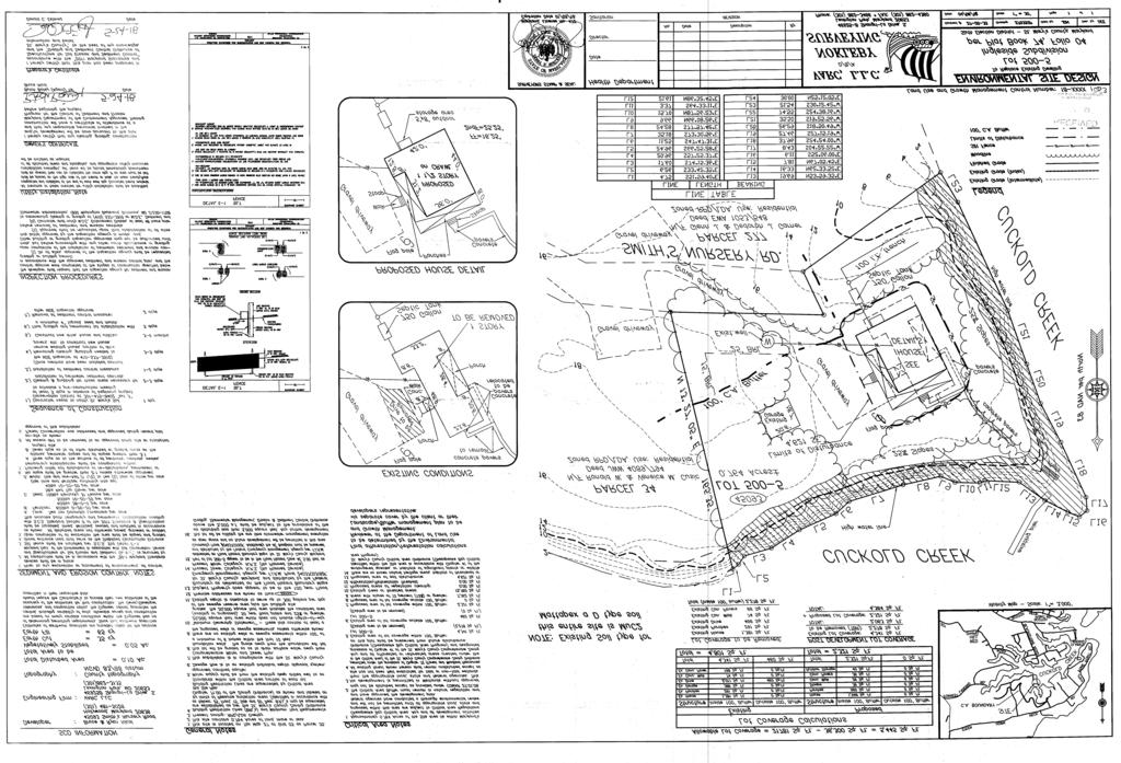
10 ATTACHMENT 4
SECTION IV. Recommended Motion: Staff recommends the following motion (with modifications and additions following discussion):
:") ST. MARY S COUNTY GOVERNMENT DEPARTMENT OF LAND USE AND GROWTH MANAGEMENT William B. Hunt, AICP, Director Kathleen Easley, Deputy Director COMMISSIONERS OF ST. MARY S COUNTY James R. Guy, President Michael
ST. MARY S COUNTY GOVERNMENT DEPARTMENT OF LAND USE AND GROWTH MANAGEMENT William B. Hunt, AICP, Director Kathleen Easley, Deputy Director COMMISSIONERS OF ST. MARY S COUNTY James R. Guy, President Michael
ST. MARY S COUNTY GOVERNMENT DEPARTMENT OF LAND USE AND GROWTH MANAGEMENT William B. Hunt, AICP, Director Kathleen Easley, Deputy Director MEMORANDUM
 ST. MARY S COUNTY GOVERNMENT DEPARTMENT OF LAND USE AND GROWTH MANAGEMENT William B. Hunt, AICP, Director Kathleen Easley, Deputy Director COMMISSIONERS OF ST. MARY S COUNTY James R. Guy, President Michael
Subject: VAAP # , Armour Property Board of Appeals Hearing of September 27, 2018
 Sr. Mnnv's CoUNTY GovERNMENT DEPARTMENT OF LAND USE AND GROWTH MANAGEMENT William B. Hunr. AICP. Director Kathleen Easley, Deputy Director COMMISSIONERS OF ST. MARY'S COUNTY James R. Guy, President Michael
R E S O L U T I O N. a. Remove Table B from the plan.
 R E S O L U T I O N WHEREAS, Werrlein Property is the owner of a 0.3902-acre parcel of land in the 5th Election District of Prince George s County, Maryland, being zoned One-Family Detached Residential
THE BUILDING PERMIT PROCESS FOR SINGLE-FAMILY DWELLINGS REVISED MAY 2006
 DEPARTMENT OF PLANNING AND ZONING Division of Inspections & Permits CUSTOMER ASSISTANCE GUIDE Visit us on the Web at: www.co.cal.md.us THE BUILDING PERMIT PROCESS FOR SINGLE-FAMILY DWELLINGS REVISED MAY
MINUTES OF THE ST. MARY S COUNTY BOARD OF APPEALS MEETING ROOM 14 * GOVERNMENTAL CENTER * LEONARDTOWN, MARYLAND Thursday, November 18, 2004
 MINUTES OF THE ST. MARY S COUNTY BOARD OF APPEALS MEETING ROOM 14 * GOVERNMENTAL CENTER * LEONARDTOWN, MARYLAND Thursday, November 18, 2004 Marie Underwood, Chairperson George Allan Hayden, Vice Chair
Chesapeake Bay Critical Area Conservation Plan
 The Maryland-National Capital Park and Planning Commission Prince George s County Planning Department Development Review Division 301-952-3530 Note: Staff reports can be accessed at www.mncppc.org/pgco/planning/plan.htm.
ISL\riT VAMANCE APPLICATION
 (A,cres For Office Use Only CASE #^0/7-^2c/J -^ FEE PAID ^0- DATE 6/9// 7 ^^ ISL\riT For Office Use Only ZONE CRITICAL AREA: IDA_LDA"^_ RCA_ BMA: Yes y No NO OF SIGNS ^- VAMANCE APPLICATION NOTE: This
MINUTE ORDER. BONNER COUNTY PLANNING and ZONING COMMISSION PUBLIC HEARING MINUTES APRIL 7, 2016
 MINUTE ORDER BONNER COUNTY PLANNING and ZONING COMMISSION PUBLIC HEARING MINUTES APRIL 7, 2016 CALL TO ORDER: Acting Chair Hall called the Bonner County Planning and Zoning Commission hearing to order
Chesapeake Bay Critical Area Conservation Plan
 The Maryland-National Capital Park and Planning Commission Prince George s County Planning Department Development Review Division 301-952-3530 Note: Staff reports can be accessed at www.mncppc.org/pgco/planning/plan.htm.
St. Mary s County Comprehensive Zoning Ordinance Article 4. OVERLAY AND FLOATING ZONES
 0 0 0 0 ARTICLE. OVERLAY DISTRICTS AND FLOATING ZONES CHAPTER 0 OVERLAY DISTRICTS, FLOATING ZONES: PURPOSE, STANDARDS, PERMITTED USES Sections: 0. Purpose of the Chesapeake Bay Critical Area Overlay. 0.
Applicant s Agent Lisa Murphy, Esq. Staff Planner PJ Scully. Lot Recordation 12/01/1972 Map Book 94, Page 33 GPIN
 Property Owner and Applicant Address 3925 Shore Drive Public Hearing September 24, 2018 City Council District Bayside Agenda Item 6 Variance Request Encroachment into the Resource Protection Area (RPA)
Chesapeake Bay Preservation Area (CBPA) Map Update. Presentation to the County Board July 15, 2017
 Map Update. Presentation to the County Board July 15, 2017") Chesapeake Bay Preservation Area (CBPA) Map Update Presentation to the County Board July 15, 2017 Chesapeake Bay Program Comprehensive Plan Chesapeake Bay Preservation Ordinance (1992) (Chapter 61, Arlington
Chesapeake Bay Preservation Area (CBPA) Map Update Presentation to the County Board July 15, 2017 Chesapeake Bay Program Comprehensive Plan Chesapeake Bay Preservation Ordinance (1992) (Chapter 61, Arlington
MINUTE ORDER BONNER COUNTY COMMISSIONERS PUBLIC HEARING MINUTES AUGUST 6, 2015
 MINUTE ORDER BONNER COUNTY COMMISSIONERS PUBLIC HEARING MINUTES AUGUST 6, 2015 CALL TO ORDER: Chair Cary Kelly called the Bonner County Commissioners hearing to order at 1:00 p.m. in the 3rd floor meeting
A. Maintenance. All legally established, nonconforming structures can be maintained (e.g., painting and repairs);
;") Chapter 24.50 NONCONFORMING USES, STRUCTURES AND LOTS Sections: 24.50.010 Nonconforming uses, structures, and lots Purpose. 24.50.020 Nonconforming uses, structures, and lots Alteration or expansion of
Chapter 24.50 NONCONFORMING USES, STRUCTURES AND LOTS Sections: 24.50.010 Nonconforming uses, structures, and lots Purpose. 24.50.020 Nonconforming uses, structures, and lots Alteration or expansion of
TALBOT COUNTY OFFICE OF PLANNING & ZONING
 TALBOT COUNTY OFFICE OF PLANNING & ZONING APPLICATION PROCEDURE FOR: MINOR VARIANCE CRITICAL AREA Refer to Article, IX, 190-182 B. Minor Variances of the Talbot County Code. If your project exceeds 10
Request to Advertise: Chesapeake Bay Preservation Area (CBPA) Map Update. June 20, 2017
 Map Update. June 20, 2017") Request to Advertise: Chesapeake Bay Preservation Area (CBPA) Map Update June 20, 2017 Outline Context Past County Board actions Why update the CBPA Map? What and Why - Resource Protection Areas Property
Request to Advertise: Chesapeake Bay Preservation Area (CBPA) Map Update June 20, 2017 Outline Context Past County Board actions Why update the CBPA Map? What and Why - Resource Protection Areas Property
CHAPTER 6 CHESAPEAKE BAY PRESERVATION AREAS AND STREAM PROTECTION AREAS
 CHAPTER 6 CHESAPEAKE BAY PRESERVATION AREAS AND STREAM PROTECTION AREAS 6.1 INTRODUCTION Virginia s Chesapeake Bay Preservation Area (CBPA) Designation and Management Regulations (9VAC10-20 et seq.) require
STAFF REPORT. Arthur and Kathleen Quiggle 4(b)
") STAFF REPORT Application: Requests related to the construction of a 28' x 41' dwelling and 6' wrap-around open deck to replace an existing 24' x 32' cabin and wrap-around open deck and the installation
STAFF REPORT Application: Requests related to the construction of a 28' x 41' dwelling and 6' wrap-around open deck to replace an existing 24' x 32' cabin and wrap-around open deck and the installation
MINUTE ORDER. BONNER COUNTY PLANNING and ZONING COMMISSION PUBLIC HEARING MINUTES NOVEMBER 5, 2015
 MINUTE ORDER BONNER COUNTY PLANNING and ZONING COMMISSION PUBLIC HEARING MINUTES NOVEMBER 5, 2015 CALL TO ORDER: Chair Temple called the Bonner County Planning and Zoning Commission hearing to order at
BEFORE THE SKAGIT COUNTY HEARING EXAMINER FINDINGS, CONCLUSIONS AND DECISION
 BEFORE THE SKAGIT COUNTY HEARING EXAMINER FINDINGS, CONCLUSIONS AND DECISION Applicant: Representative: File Nos: Requests: Location: Donald Hansen & Brooke Ghen 2026 Cliff Drive, Suite 157 Santa Barbara,
NOTICE OF PUBLIC HEARING
 NOTICE OF PUBLIC HEARING NOTICE IS HEREBY GIVEN that the Commissioners of St. Mary s County will hold a Public Hearing on Tuesday, May 15, 2018, beginning at 11:00 a.m. in the Chesapeake Building located
ARTICLE 5. DEFINITIONS
 Article. DEFINITIONS 0 0 0 ARTICLE. DEFINITIONS CHAPTER 0 DEFINITIONS Accessory Structure, Building or Use. A building or use that is all of the following: a) constructed or located on the same zoning
MINUTES OF THE ST. MARY S COUNTY BOARD OF APPEALS ROOM 14 * GOVERNMENTAL CENTER * LEONARDTOWN, MARYLAND Thursday, September 14, 2006
 MINUTES OF THE ST. MARY S COUNTY BOARD OF APPEALS ROOM 14 * GOVERNMENTAL CENTER * LEONARDTOWN, MARYLAND Thursday, September 14, 2006 Members present were George Allan Hayden, Chair; Greg Callaway, Vice
CONDITIONAL USE PERMIT Application Packet
 CONDITIONAL USE PERMIT Application Packet Community Development Department 1020 East Pioneer Road, Draper, UT 84020 (801) 576-6539 Fax (801) 576-6526 Dear Applicant, This application packet has been developed
Finnerty, Shawn & Lori Water Front Setback
 BONNER COUNTY PLANNING DEPARTMENT BOARD OF COUNTY COMMISSIONERS STAFF REPORT FOR JANUARY 10, 2018 Project Name: Finnerty, Shawn & Lori Water Front Setback File Number, Type: FILE #V492-17, Variance Request
Finnerty, Shawn & Lori Water Front Setback
 BONNER COUNTY PLANNING DEPARTMENT PLANNING AND ZONING COMMISSION STAFF REPORT FOR NOVEMBER 2, 2017 Project Name: Finnerty, Shawn & Lori Water Front Setback File Number, Type: FILE #V492-17, Variance Request
ARLINGTON COUNTY, VIRGINIA. County Board Agenda Item Meeting of June 17, 2017
 ARLINGTON COUNTY, VIRGINIA County Board Agenda Item Meeting of June 17, 2017 DATE: June 9, 2017 SUBJECT: Request to authorize advertisement of public hearings by the Planning Commission and County Board
VARIANCE APPLICATION PACKET
 VARIANCE APPLICATION PACKET A variance is a modification of the specific provisions of the Unified Development Ordinance (UDO) granted when strict enforcement of the UDO would cause undue hardship owing
Regulatory Fee Schedule
 Regulatory Schedule STATE OF NEW JERSEY DEPARTMENT OF ENVIRONMENTAL PROTECTION DIVISION OF LAND USE REGULATION Website: www.state.nj.gov/dep/landuse Revised September 2017 All permit fees shall be paid
MINUTES OF THE ST. MARY S COUNTY PLANNING COMMISSION MEETING ROOM 14 * GOVERNMENTAL CENTER * LEONARDTOWN, MARYLAND Monday, October 23, 2006
 MINUTES OF THE ST. MARY S COUNTY PLANNING COMMISSION MEETING ROOM 14 * GOVERNMENTAL CENTER * LEONARDTOWN, MARYLAND Monday, October 23, 2006 Members present were Steve Reeves, Chair; Lawrence Chase; Merl
Guidelines for Construction of Recreational Buildings and Improvements Greater than 1000 Square Feet Outside Acceptable Development Areas
 Guidelines for Construction of Recreational Buildings and Improvements Greater than 1000 Square Feet Outside Acceptable Development Areas The following guidelines are established by the Easement Committee
* * * * * * * * * * * * * * * * * * * * * * * * * FINDINGS OF FACT AND CONCLUSIONS OF LAW
 IN RE: PETITIONS FOR SPECIAL HEARING, * BEFORE THE SPECIAL EXCEPTION AND VARIANCE * DEPUTY ZONING W side of Main Street, 225 feet N of c/l of East Chadsworth Avenue * COMMISSIONER 4 th Election District
PLANNING & DEVELOPMENT SERVICES 1800 Continental Place Mount Vernon, WA Inspections Office Fax 360.
 PLANNING & DEVELOPMENT SERVICES 1800 Continental Place Mount Vernon, WA 98273 Inspections 360.416.1330 Office 360.416-1320 Fax 360.416-1340 Date Received: Administrative Setback Reduction Checklist Pursuant
Conservation Design Subdivisions
 Conservation Design Subdivisions An excerpt from the Rules and Regulations Governing Division of Land in Sheridan County, Wyoming, November 5, 2010 Sheridan County Public Works Department 224 S. Main Street
Spirit Lake North, LLC
 BONNER COUNTY PLANNING DEPARTMENT PLANNING AND ZONING COMMISSION STAFF REPORT FOR March 1, 2018 Project Name: Amendment & Zone Change: Spirit Lake North, LLC File Number,Type: AM 162-18/ZC365-18 Request:
ARTICLE VII: CHARLES CITY COUNTY SEPTIC SYSTEM CONTROL ORDINANCE
 ARTICLE VII: CHARLES CITY COUNTY SEPTIC SYSTEM CONTROL ORDINANCE Adopted: July 1, 1994 CHARLES CITY COUNTY SEPTIC SYSTEM CONTROL ORDINANCE Section 1.0 Title This Ordinance shall be known as the Charles
Eagle Harbor 2025: Planning for a Sustainable Community
 THIS IS EAGLE HARBOR Location and History piers, bathhouses, hotels for seasonal guests, a merry-go-round and park, shops, food and beverage businesses and a tearoom. The Town of Eagle Harbor is in the
MINUTES OF THE ST. MARY S COUNTY PLANNING COMMISSION MEETING ROOM 14 * GOVERNMENTAL CENTER * LEONARDTOWN, MARYLAND Monday, May 8, 2006
 MINUTES OF THE ST. MARY S COUNTY PLANNING COMMISSION MEETING ROOM 14 * GOVERNMENTAL CENTER * LEONARDTOWN, MARYLAND Monday, May 8, 2006 Members present were Joseph St. Clair, Chair; Steve Reeves, Vice Chair;
Instructions to the Applicant
 CONDITIONAL USE PERMIT APPLICATION Lake of the Woods County Land and Water Planning Office 206 8 th Avenue Southeast, Suite #290 Baudette MN 56623-2867 www.co.lake-of-the-woods.mn.us Phone: (218) 634-1945
SUBDIVISION APPLICATION
 SUBDIVISION APPLICATION Community Planning and Economic Development Development Services Division 250 South 4 th Street, Room 300 Minneapolis MN 55415-1316 612-673-3000 This application packet is used
Easement Program Guidelines for Locating Towers and Communication Devices
 Easement Program Guidelines for Locating Towers and Communication Devices The following guidelines are established by the Easement Committee to create standards for reviewing requests by landowners to
Resource Protection Area Map Update - Frequently Asked Questions
 DEPARTMENT OF ENVIRONMENTAL SERVICES Office of Sustainability and Environmental Management 2100 Clarendon Boulevard, Suite 705, Arlington, VA 22201 TEL 703-228-4488 FAX 703-228-7134 TTY 703-228-4611 www.arlingtonva.us
FREQUENTLY USED PLANNING & ZONING TERMS
 City Of Mustang FREQUENTLY USED PLANNING & ZONING TERMS Abut: Having property lines, street lines, or zoning district lines in common. Accessory Structure: A structure of secondary importance or function
MULTI-FAMILY DWELLING UNIT SUBDIVISION ORDINANCE TOWN OF SIDNEY, MAINE
 MULTI-FAMILY DWELLING UNIT SUBDIVISION ORDINANCE TOWN OF SIDNEY, MAINE I. GENERAL A. Title B. Purpose C. Administration D. Scope II. DEFINITIONS A. Building Height B. Dwelling Unit C. Family D. Multi-Unit
ORDINANCE NO. _4.06 AN ORDINANCE TO ESTABLISH BUILDING SITE REGULATIONS SECTION A PURPOSE AND INTENT
 ORDINANCE NO. _4.06 AN ORDINANCE TO ESTABLISH BUILDING SITE REGULATIONS SECTION A PURPOSE AND INTENT This Ordinance provides minimum regulations, provisions and requirements for safe, aesthetically pleasing
Easement Program Guidelines for Water Resources and Stream Work
 Easement Program Guidelines for Water Resources and Stream Work The following guidelines are established by the Easement Committee to create standards for reviewing requests by landowners to conduct stream
BEFORE THE HEARING EXAMINER FOR THURSTON COUNTY
 COUNTY COMMISSIONERS Cathy Wolfe District One Diane Oberquell District Two Robert N. Macleod District Three HEARING EXAMINER BEFORE THE HEARING EXAMINER FOR THURSTON COUNTY In the Matter of the Application
CHESAPEAKE BAY PRESERVATION AREA EXCEPTION APPLICATION INSTRUCTIONS
 City of Chesapeake Department of Planning Post Office Box 15225 Chesapeake, Virginia 23328-5225 (757) 382-6176 FAX (757) 382-6406 CHESAPEAKE BAY PRESERVATION AREA EXCEPTION APPLICATION INSTRUCTIONS PURPOSE
Open Space Model Ordinance
 Open Space Model Ordinance Section I. Background Open space development has numerous environmental and community benefits, including: 1) Reduces the impervious cover in a development. Impervious cover
Legal Description Part of the Western Half of the Eastern Half of the Northwest Quarter of Section 30, Le Ray Township
 Owner and Applicant s 20448 State Highway 83 Mankato, MN 56001 Request and Location Request for review and approval of a Conditional Use Permit to allow an Elder Care Residential Unit to be constructed
Purpose: Regulations:
 Administrative Procedures for the Designation and Refinement Of Chesapeake Bay Preservation Area Boundaries Guidance on the Chesapeake Bay Preservation Area Designation and Management Regulations September,
CHARLES CITY COUNTY SITE PLAN ORDINANCE. This Ordinance shall be known as the Charles City County Site Plan Ordinance.
 CHARLES CITY COUNTY SITE PLAN ORDINANCE Section 1. Title This Ordinance shall be known as the Charles City County Site Plan Ordinance. Section 2. Authority. This Ordinance is enacted pursuant to the authority
STAFF REPORT. Permit Number: Porter. Kitsap County Board of Commissioners; Kitsap County Planning Commission
 STAFF REPORT Permit Number: 15 00461 Porter DATE: November 9, 2015 TO: FROM: Kitsap County Board of Commissioners; Kitsap County Planning Commission Katrina Knutson, AICP, Senior Planner, DCD and Jeff
TOWN OF BRASELTON, GEORGIA STREAM BUFFER AND SETBACK VARIANCE APPLICATION
 TOWN OF BRASELTON, GEORGIA STREAM BUFFER AND SETBACK VARIANCE APPLICATION An applicant seeking a grant of variance from the stream buffer protection regulations found in Section 15.5 of the Town of Braselton
Variance 1: A variance for a front yard from the required 10 feet to 4 feet for the construction of an elevator; and,
 GROWTH AND RESOURCE MANAGEMENT DEPARTMENT PLANNING AND DEVELOPMENT SERVICES DIVISION CURRENT PLANNING ACTIVITY 123 W. Indiana Avenue, DeLand, FL 32720 (386) 736-5959 PUBLIC HEARING: CASE NO: SUBJECT: LOCATION:
R E S O L U T I O N. 2. Development Data Summary
 R E S O L U T I O N WHEREAS, the Prince George's County Planning Board is charged with the approval of Detailed Site Plans pursuant to Part 3, Division 9 of the Zoning Ordinance of the Prince George's
Town of Middleborough Conservation Commission 2014 Policy
 Approved February 20, 2014 Town of Middleborough Conservation Commission 2014 Policy The Wetland Protection Act under M.G.L. c. 131, sec. 40 and regulations 310 CMR 10.02(1)(a-f) & 310 CMR 10.02 (2)(a)
SECTION 4: PRELIMINARY PLAT
 SECTION 4: PRELIMINARY PLAT After the completion of the sketch plan process, if submitted, the owner or developer shall file with the City an application for preliminary plat. The preliminary plat stage
ARTICLE IX. CHESAPEAKE BAY PRESERVATION AREA DISTRICT
 ARTICLE IX. CHESAPEAKE BAY PRESERVATION AREA DISTRICT Sec. 26-512. - Findings. Ordinance Adopted 12/9/03 Amended 05/27/14 The Chesapeake Bay and its tributaries ("the Bay") are one of the most important
***** Subchapter A. GENERAL PROVISIONS ***** PERMIT APPLICATIONS
 105.11. Permit requirements. 105.12. Waiver of permit requirements. Title 25 Environmental Protection Part I. Department of Environmental Protection Subpart C. Protection of Natural Resources Article I.
ARLINGTON COUNTY CODE. Chapter 61 CHESAPEAKE BAY PRESERVATION ORDINANCE*
 Chapter 61 CHESAPEAKE BAY PRESERVATION ORDINANCE* * Editors Note: Ord. No. 03-1, adopted Feb. 8, 2003, amended Ch. 61, in its entirety, to read as herein set out in 61-1-61-19. 61-1. Title 61-2. Purpose
STAFF REPORT and INFORMATION FOR THE HEARING EXAMINER. Project: Westphal Accessory Dwelling Unit (ADU)
") KITSAP COUNTY DEPARTMENT OF COMMUNITY DEVELOPMENT 614 DIVISION STREET MS-36, PORT ORCHARD WASHINGTON 98366-4682 LARRY KEETON, DIRECTOR (360) 337-7181 FAX (360) 337-4925 HOME PAGE - www.kitsapgov.com STAFF
KITSAP COUNTY DEPARTMENT OF COMMUNITY DEVELOPMENT 614 DIVISION STREET MS-36, PORT ORCHARD WASHINGTON 98366-4682 LARRY KEETON, DIRECTOR (360) 337-7181 FAX (360) 337-4925 HOME PAGE - www.kitsapgov.com STAFF
FRESHWATER WETLANDS PROTECTION IN NEW JERSEY Tools for Municipal Action
 FRESHWATER WETLANDS PROTECTION IN NEW JERSEY Tools for Municipal Action The Freshwater Wetlands Protection Act INTENT OF FRESHWATER WETLANDS LAW The New Jersey legislature passed the Freshwater Wetlands
BONNER COUNTY PLANNING DEPARTMENT PLANNING & ZONING COMMISION STAFF REPORT APRIL 19, 2018
 BONNER COUNTY PLANNING DEPARTMENT PLANNING & ZONING COMMISION STAFF REPORT APRIL 19, 2018 Project Name: File Number,Type: Request: Legal Description: Location: Parcel Size: Parcel # Applicant: Project
A. ARTICLE 16 - STEEP SLOPE CONSERVATION DISTRICT
 1600. 1601.A. ARTICLE 16 - STEEP SLOPE CONSERVATION DISTRICT SECTION 1600 PURPOSE The purpose of this Article is to expand upon the Community Development Objectives associated with environmental protection
July 19, 2018 Planning and Land Development Regulation Commission (PLDRC)
") Page 1 of 15 GROWTH AND RESOURCE MANAGEMENT DEPARTMENT PLANNING AND DEVELOPMENT SERVICES DIVISION 123 West Indiana Avenue, DeLand, Florida 32720 (386) 736-5959 PUBLIC HEARING: CASE NO: SUBJECT: LOCATION:
Page 1 of 15 GROWTH AND RESOURCE MANAGEMENT DEPARTMENT PLANNING AND DEVELOPMENT SERVICES DIVISION 123 West Indiana Avenue, DeLand, Florida 32720 (386) 736-5959 PUBLIC HEARING: CASE NO: SUBJECT: LOCATION:
Zoning/Building Permit Application
 Zoning/Building Permit Application Location Address: Zoning District: Parcel #: -0626 Subdivision Name: Lot Size: CONTACT INFORMATION: Applicant s Name Address _ Email Owner s Name Address _ Email Professional
204 Minor Subdivision & Large Lot Division
 204 Minor Subdivision & Large Lot Division 204.01 Purpose and Intent 204.05 General Procedures 204.10 Large Lot Division 204.02 Comprehensive Land Use 204.06 Submittal Requirements Plan Policies 204.07
Article 5. Environmentally Sensitive Areas
 Article 5. Environmentally Sensitive Areas This Article establishes standards and regulations governing environmental constraints. These regulations are intended to encourage preservation of lands designated
Boyertown Borough and Colebrookdale and Pike Townships Joint Zoning Ordinance
 Boyertown Borough and Colebrookdale and Pike Townships Joint Zoning Ordinance Berks County, Pennsylvania Effective Date - November 7, 2010 This Ordinance was prepared under the direction of the Boyertown
Ensures that all perennial streams and connected wetland are identified and protected for projects that disturb more than 2,500 sf of land.
 Page 1 of 22 A. MAP ISSUES 1. How should the Resource Protection Area (RPA) be mapped? The draft Chesapeake Bay Preservation Area Map ( the Map ) is general in nature and is not intended to depict the
MINUTE ORDER. BONNER COUNTY PLANNING and ZONING COMMISSION PUBLIC HEARING MINUTES JULY 23, 2015
 MINUTE ORDER BONNER COUNTY PLANNING and ZONING COMMISSION PUBLIC HEARING MINUTES JULY 23, 2015 CALL TO ORDER: Chair Roger Daar called the Bonner County Planning and Zoning Commission hearing to order at
Article 6 Development Permits. Division 5: Site Development Permit Procedures (Added by O N.S.; effective
 Article 6 Development Permits Division 5: Site Development Permit Procedures (Added 12-9-1997 by O-18451 N.S.; effective 1-1-2000.) 126.0501 Purpose of the Site Development Permit Procedures The purpose
CITY OF GRAND JUNCTION, COLORADO
 CITY OF GRAND JUNCTION, COLORADO ORDINANCE NO. 4778 AN ORDINANCE AMENDING VARIOUS SECTIONS OF THE ZONING AND DEVELOPMENT CODE (TITLE 21 OF THE GRAND JUNCTION MUNICIPAL CODE) REGARDING ADMINISTRATION AND
MONTGOMERY COUNTY PLANNING DEPARTMENT THE MARYLAND-NATIONAL CAPITAL PARK AND PLANNING COMMISSION
 MONTGOMERY COUNTY PLANNING DEPARTMENT THE MARYLAND-NATIONAL CAPITAL PARK AND PLANNING COMMISSION MCPB Item No. Hearing Date: 10/8/15 Howard Hughes Medical Institute, Limited Amendment of the Preliminary
MONTGOMERY COUNTY PLANNING BOARD
 MONTGOMERY COUNTYPLANNING BOARD T H E MARYLAND-NATIONAL CAPITAL PARK A N D P L A N N I N G C O M M I S S I O N MCPB NO. 10-100 Preliminary Plan No. 120100210 Date of Hearing: July 1, 2010 MONTGOMERY COUNTY
Directions For Filling Out A CAMA MINOR Permit
 Directions For Filling Out A CAMA MINOR Permit Please fill out the application completely including applicant's signature on the second page. Be sure to complete the "statement of ownership" and the "adjacent
French, Bruce. The applicant is requesting a zone change from Suburban to Rural Service Center.
 BONNER COUNTY PLANNING DEPARTMENT PLANNING AND ZONING COMMISSION STAFF REPORT FOR FEBRUARY 2, 2017 Project Name: French, Bruce File Number,Type: ZC358-16, Zone Change Request: The applicant is requesting
9 November 12, 2014 Public Hearing
 9 November 12, 2014 Public Hearing APPLICANT AND PROPERTY OWNER: GARRETT A. & BERNADETTE P. ALCARAZ STAFF PLANNER: Kristine Gay REQUEST: Subdivision Variance to Section 4.4(b) of the Subdivision Ordinance,
Anyone speaking to the Planning Commission shall state their name and address for the record. Thank you.
 Blue Earth County Planning Commission Members: Chair Lyle Femrite, Kurt Anderson, Bill Anderson, Kip Bruender, Charles Grams, Barry Jacques and Joe Smentek. 1. CALL TO ORDER AGENDA Blue Earth County Planning
Spence Carport Variance
 Spence Carport Variance ACTIVITY #: BOARD OF ADJUSTMENTS HEARING DATE: PL-15-1042 12/14/2015 at 6:00 pm PETITIONER: PETITION: LOCATION: ZONE DISTRICT: AREA OF PARCEL: REQUIRED SETBACKS: STAFF CONTACT:
The Maryland Puritan Tiger Beetle Habitat Conservation Program
 The Maryland Puritan Tiger Beetle Habitat Conservation Program Maryland Department of Natural Resources Annapolis, MD 21401 October 2011 The Maryland Puritan Tiger Beetle Habitat Conservation Program October
Eric Feldt, Planner II, CFM Community Development Department
 DATE: August 28, 2014 TO: FROM: Board of Adjustment Eric Feldt, Planner II, CFM Community Development Department FILE NO.s: VAR2014 0017 & VAR2014 0018 PROPOSAL: A Variance to reduce two side yard setbacks
Project Information. Request. Required Attachments
 Variance Application Use this form for all variance applications, including administrative reductions in setbacks. A variance application may be accompanied by another permit application that depends on
COMMUNITY DEVELOPMENT DEPARTMENT 333 Broadalbin Street SW, P.O. Box 490 Albany, OR 97321
 COMMUNITY DEVELOPMENT DEPARTMENT 333 Broadalbin Street SW, P.O. Box 490 Albany, OR 97321 Ph: 541-917-7550 Fax: 541-917-7598 www.cityofalbany.net STAFF REPORT Application for Site Plan Review SP-07-18 and
ADAMS COUNTY CONSERVATION DISTRICT S
 Approved by District Board on 12-15-2016 I. Authority & Applicability of Fees for Services A. Authority - The Adams County Conservation District is delegated with the responsibility to administer the Commonwealth
EXTRA TERRITORIAL ZONING AUTHORITY CASE ANALYSIS
 DOÑA ANA COUNTY CASE # V09-007 COMMUNITY PLANNING AND ECONOMIC DEVELOPMENT DEPARTMENT Building Planning GIS 845 North Motel Boulevard Las Cruces, New Mexico 88007 (575) 647-7350 Fax: (575) 525-6131 Toll
VARIANCE CASE SUMMARY
 CITY OF SNELLVILLE PLANNING & DEVELOPMENT DEPARTMENT BOARD OF APPEALS VARIANCE CASE SUMMARY December 12, 2017 CASE NUMBER: #BOA 17-09 REQUEST: APPLICABLE SECTION(S): LOCATION: Variances from the Snellville
TOWN OF HOLLIS, NEW HAMPSHIRE
 TOWN OF HOLLIS, NEW HAMPSHIRE BUILDOUT ANALYSIS NOVEMBER 20, 2001 Prepared by the NASHUA REGIONAL PLANNING COMMISSION TABLE OF CONTENTS I. INTRODUCTION...1 II. GOAL OF THE BUILDOUT ANALYSIS...1 III. METHODOLOGY...1
St. Mary s County Government. Land Use & Growth Management Citizens Academy September 30, PM
 St. Mary s County Government Land Use & Growth Management Citizens Academy September 30, 2014 6-9 PM County Organizational Chart Aging & Human Services Economic Development Finance Human Resources Citizens
Taylor Lot Coverage Variance Petition No. PLNBOA North I Street Public Hearing: November 7, 2012
 APPEALS HEARING OFFICER STAFF REPORT Applicant: Mark Taylor, property owner Staff: Thomas Irvin (801) 535-7932 thomas.irvin@slcgov.com Tax ID: 09-32-159-006-0000 Current Zone: SR-1A Special Development
VANCE COUNTY BOARD OF ADJUSTMENTS
 VANCE COUNTY BOARD OF ADJUSTMENTS The Vance County Board of Adjustments met at a regular and duly advertised meeting on October 15, 2015 at 4:00 p.m. in the Commissioners Meeting Room of the Vance County
TRUSTT GILES REQUEST: APPLICANT: C AND C DEVELOPMENT. Page (b) of the all the AICUZ: SITE SIZE: 28,261 TOTAL 17,417 UPLAND GPIN:
 of the all the AICUZ: SITE SIZE: 28,261 TOTAL 17,417 UPLAND GPIN:") STAFF PLANNER: Carolyn A.K. Smith REQUEST: Subdivision Variance to Section 4.4(b) of the Subdivision Ordinance that requires all newly created lots meet all the requirements of the City Zoning Ordinance
STAFF PLANNER: Carolyn A.K. Smith REQUEST: Subdivision Variance to Section 4.4(b) of the Subdivision Ordinance that requires all newly created lots meet all the requirements of the City Zoning Ordinance
August 13, Planning and Land Development Regulation Commission (PLDRC)
") Page 1 of 16 GROWTH AND RESOURCE MANAGEMENT DEPARTMENT PLANNING AND DEVELOPMENT SERVICES DIVISION CURRENT PLANNING ACTIVITY 123 W. Indiana Avenue, DeLand, FL 32720 (386) 736-5959 PUBLIC HEARING: CASE NO:
Page 1 of 16 GROWTH AND RESOURCE MANAGEMENT DEPARTMENT PLANNING AND DEVELOPMENT SERVICES DIVISION CURRENT PLANNING ACTIVITY 123 W. Indiana Avenue, DeLand, FL 32720 (386) 736-5959 PUBLIC HEARING: CASE NO:
MINUTES OF THE ST. MARY S COUNTY PLANNING COMMISSION MEETING ROOM 14 * GOVERNMENTAL CENTER * LEONARDTOWN, MARYLAND Monday, February 9, 2004
 MINUTES OF THE ST. MARY S COUNTY PLANNING COMMISSION MEETING ROOM 14 * GOVERNMENTAL CENTER * LEONARDTOWN, MARYLAND Monday, February 9, 2004 Members present were John F. Taylor, Sr., Chairperson; Larry
Major Subdivision Application Packet. Revised June 2018
 Major Subdivision Application Packet Revised June 2018 Caroline County Department of Planning and Community Development 233 West Broaddus Avenue Bowling Green, VA 22427 www.co.caroline.va.us Phone: 804-633-4303
Mr. Hanson called the meeting to order at 12:00 p.m.
 DORCHESTER COUNTY PLANNING COMMISSION MINUTES June 6, 2018 The Dorchester County Planning Commission held their regular meeting on June 6, 2018 at 12:00 pm in the County Office Building, Room 110 in Cambridge
Draft Zoning Changes for the 2nd Planning Board Public Hearing, January 22, 2018.
 Draft Zoning Changes for the 2nd Planning Board Public Hearing, January 22, 2018. No changes were made at the 1st Public Hearing. Proposed wording for the 1 st Public Hearing in red, eliminated text in
BOA Howard Tauer Centerline Setback Variance 07/11/12
 BOA 09-12 Howard Tauer Centerline Setback Variance 07/11/12 Request for an after-the-fact variance to reduce the required centerline setback from 130 feet to 65 feet for a partially constructed deck located