CITY OF DALLAS. CITY PLAN COMMISSION Thursday, February 3, 2011 AGENDA. BRIEFINGS: 5ES 12:00 p.m. PUBLIC HEARING Council Chambers 1:30 p.m.
|
|
|
- Beverly Bates
- 5 years ago
- Views:
Transcription
1 CITY OF DALLAS CITY PLAN COMMISSION Thursday, February 3, 2011 AGENDA BRIEFINGS: 5ES 12:00 p.m. PUBLIC HEARING Council Chambers 1:30 p.m. *The City Plan Commission may be briefed on any item on the agenda if it becomes necessary. BRIEFINGS: Subdivision Docket Zoning Docket ACTION ITEMS: Theresa O Donnell, Director David Cossum, Assistant Director of Current Planning Subdivision Docket Planner: Paul Nelson Consent Items: (1) S (CC District 14) (2) S (CC District 2) An application to replat a acre tract of land acre tract of land and part of abandoned Blackburn Street into one acre lot in City Block 984 on Blackburn Street between N. Central Expressway and Noble Avenue Applicant/Owner: JLB Cityplace, LP Surveyor: Spiars Engineering, Inc. Application Filed: January 12, 2011 Zoning: PD 305, Sub district D-1, west mixed use district Staff Recommendation: Approval, subject to compliance with the conditions listed in the docket. An application to create a acre lot from a tract of land in City Block 5721 in the 6100 block of Maple Avenue between Kimsey Street and Bomar Street. Applicant/Owner: JLB Maple Partners, LP Surveyor: Spiars Engineering, Inc. Application Filed: January 12, 2011 Zoning: MU-2 Staff Recommendation: Approval, subject to compliance with the conditions listed in the docket. Sustainable Development and Construction
2 City Plan Commission February 3, 2011 (3) S (CC District 2) (4) S (CC District 14) (5) S (CC District 14) (6) S (CC District 14) An application to replat a acre tract of land containing all of lots 3, 4, 5, 6, 7, 8, 9, 10 and part of lots 1 and 2 in City Block 6/856 into one lot on property located on 1610 S. Malcolm X Boulevard at Dawson Drive, north corner. Applicant/Owner: CDM City of Hope, Inc./City Square Surveyor: Goodwin & Marshall Application Filed: January 13, 2011 Zoning: IM Staff Recommendation: Approval, subject to compliance with the conditions listed in the docket. An application to replat all of Lots 15 and 16 in City Block D/1056 into one acre lot located at 4019 Bowser Avenue between Knight Street and Throckmorton Street. Owner: Texas Intown Homes, LLC Surveyor: C.B.G. Surveying, Inc. Application Filed: January 14, 2011 Zoning: PD 193 (MF-2) Staff Recommendation: Approval, subject to compliance with the conditions listed in the docket. An application to replat all of Lots 9 and 10 in City Block 3/1567 into one acre lot located at 3923 and 3931 Holland Avenue at Throckmorton Street, south corner. Owner: Texas Intown Homes, LLC Surveyor: C.B.G. Surveying, Inc. Application Filed: January 14, 2011 Zoning: PD 193 (MF-2) Staff Recommendation: Approval, subject to compliance with the conditions listed in the docket. An application to replat all of Lots 1, 2 and part of Lot 3 in City Block 2/1336 into one acre lot located at 2803 thru 2811 Shelby Avenue and 3910 Congress. Owner: Texas Intown Homes, LLC Surveyor: C.B.G. Surveying, Inc. Application Filed: January 14, 2011 Zoning: PD 193 (MF-3) Staff Recommendation: Approval, subject to compliance with the conditions listed in the docket. 2
3 City Plan Commission February 3, 2011 (7) S (CC District 14) (8) S (CC District 2) An application to replat all of Lot 18 in City Block A/1324 into five lots ranging in size from 1,536 square feet to 2,504 square feet in size located at 4001 N. Hall Street at Throckmorton Street, west corner. Owner: Texas Intown Homes, LLC Surveyor: C.B.G. Surveying, Inc. Application Filed: January 14, 2011 Zoning: PD 193 (MF-2) Staff Recommendation: Approval, subject to compliance with the conditions listed in the docket. An application to create one acre lot, one acre lot and one acre lot from a acre tract of land in City Block 7940 on Mockingbird Lane and Stemmons Freeway. Owner: Stemmons Plaza, c/o Bobby Cox Companies Surveyor: Salcedo Group, Inc. Application Filed: January 14, 2011 Zoning: MU-3 Staff Recommendation: Approval, subject to compliance with the conditions listed in the docket. Individual Items: (9) S (CC District 3) (10) S (CC District 13) An application to replat a acre tract of land containing all of Lots 1, 2 and 3 in City Block 15/7130 into one lot at 1917, 1919 and 1923 Bayside Street between Harston Street and Puget Street. Owner: Community Care Fellowship Surveyor: Shields and Lee Surveying Application Filed: January 6, 2011 Zoning: R-5(A) Staff Recommendation: Denial An application to replat an acre tract of land into 1 lot and containing all of Lots 1A, 1B, 1C, 1D, Lot 2A and the remainder of Lots 1 and 2 in City Block N/6431 and Assembly Court to be abandoned on property between Webb Chapel Road and Pensive Drive south of Merrell Road. Owner: Dallas Independent School District Surveyor: Pacheco Koch Engineers Application Filed: January 7, 2011 Zoning:R-10(A) Staff Recommendation: Approval, subject to compliance with the conditions listed in the docket. 3
4 City Plan Commission February 3, 2011 (11) S (District 13) An application to replat all of Lot 4 and part of Lot 5 in City Block 14/5587 of the Subdivision of Block 14, Sunnybrook Estates Addition into one acre lot fronting feet on 9762 Audubon Place. Owner: Randy and Nancy Best Surveyor: C.B.G. Surveying, Inc. Application Filed: January 12, 2011 Zoning: R-1ac.(A) Staff Recommendation: Approval, subject to compliance with the conditions listed in the docket. Miscellaneous Docket M Richard Brown (CC District 1) D Olga Torres Holyoak (CC District 9) D Olga Torres Holyoak (CC District 9) D Olga Torres Holyoak (CC District 9) Minor Amendment to the development plan and landscape plan for Planned Development District No. 306 for a Public school and Community service center on the west line of Edgefield Avenue between Brooklyn Avenue and Twelfth Street. Staff Recommendation: Approval Applicant: Dallas Independent School District Representative: Karl Crawley Development plan for Planned Development District No. 742 on the northeast side of Northwest Highway, west of Skillman Road. Staff Recommendation: Approval Applicant: Whataburger Restaurants, LP Representative: Janet Reid Development plan and landscape plan for Planned Development District No. 742 on the northeast side of Northwest Highway, west of Skillman Road. Staff Recommendation: Approval Applicant: TC Timbercreek Associates, L.P. Representative: Robert Brandt Development plan for Planned Development District No. 742 on the northeast side of Northwest Highway, west of Skillman Road. Staff Recommendation: Approval Applicant: TC Timbercreek Associates, L.P. Representative: Robert Brandt 4
5 City Plan Commission February 3, 2011 D Olga Torres Holyoak (CC District 9) Development plan for Planned Development District No. 742 on the northeast side of Northwest Highway, west of Skillman Road. Staff Recommendation: Approval Applicant: TC Timbercreek Associates, L.P. Representative: Robert Brandt Zoning Cases Consent 1. Z (OTH) Olga Torres Holyoak (CC District 6) 2. Z (RB) Richard Brown (CC District 7) 3. Z (RB) Richard Brown (CC District 2) An application for a Specific Use Permit for an industrial (inside) for light manufacturing on property zoned Planned Development District No. 784, the Trinity River Corridor Special Purpose District, on the east side of Rock Island Street, north of Bessemer Street. Staff Recommendation: Approval for a five-year period, subject to a site plan and conditions. Applicant: Hargett Electric Company Representative: Peter Kavanagh, Zone Systems, Inc. An application for the renewal of Specific Use Permit No for a Bar, lounge, or tavern on property zoned Planned Development District No. 269, the Deep Ellum/Near East Side Special Purpose District on the southwest line of Exposition Avenue, west of Parry Avenue. Staff Recommendation: Approval for a three-year period, subject to a site plan and conditions. Applicant: Exposition Taverns-Michael Scheel, Sheldon Hubbard-Partners Representative: Michael Scheel An application for a CR Community Retail District on property zoned an NO(A) Neighborhood Office District on the northwest line of Garrett Avenue, northwest of Ross Avenue. Staff Recommendation: Approval Applicant: Tom Miller Representative: Bryan M. Buerger 5
6 City Plan Commission February 3, 2011 Zoning Cases Under Advisement 4. Z (RB) Richard Brown (CC District 2) 5. Z (RB) Richard Brown (CC District 2) An application for a Specific Use Permit for a Bail bonds office on property within Planned Development District No. 784, the Trinity River Corridor Special Purpose District on the southwest corner of Reunion Boulevard and the Interstate 35 Southbound Access Road. Staff Recommendation: Approval for a two-year period, with eligibility for automatic renewal for additional two-year periods, subject to a site plan and conditions. Applicant: Texas Bail Bonds Representative: Santos Martinez U/A From: January 6, 2011 and January 20, 2011 An application for a Specific Use Permit for a Bail bonds office on property zoned as Planned Development District No. 784, the Trinity River Corridor Special Purpose District, on the southeast corner of Reunion Boulevard and Riverfront Boulevard. Staff Recommendation: Approval for a two-year period, with eligibility for automatic renewal for additional two-year periods, subject to a site plan and conditions. Applicant: Jullis Acosta Mata Representative: Santos Martinez U/A From: January 20, 2011 Development Code Amendment Under Advisement DCA David Cossum Consideration of amendments to Article IV, Use Regulations, of Chapter 51 and Chapter 51A, the Dallas Development Code, to create an alternative financial establishment use, establishing what districts the use will be permitted in and providing appropriate regulations for the use. Staff Recommendation: Approval ZOC Recommendation: Denial U/A From: January 20, 2011 Land Use Plan West Dallas Urban Structure and Guidelines David Whitley Consideration of the adoption of the West Dallas Urban Structure and Guidelines. This study, if adopted, will be used as an urban design, planning and implementation guide for future development in the area generally bounded by Interstate 30 to the south, Sylvan Avenue to the west, and the Trinity River Levee to the north and east. Staff Recommendation: Approval 6
7 City Plan Commission February 3, 2011 Other Matters Minutes: January 20, 2011 and January 27, 2011 Adjournment 7
8 CITY PLAN COMMISSION PUBLIC COMMITTEE MEETINGS City Plan Commission February 3, 2011 Thursday, February 3, 2011 ZONING ORDINANCE COMMITTEE (ZOC) MEETING - Thursday, February 3, 2011, City Hall, 1500 Marilla Street, in 5ES, at 9:00 a.m., to consider (1) DCA Consideration of amending the Dallas Development Code to amend parking regulations. Tuesday, February 8, 2011 SPECIAL SIGN DISTRICT ADVISORY COMMITTEE (SSDAC) is scheduled to meet on Tuesday, February 8, 2011, City Hall, 1500 Marilla Street. Note: The official Special Sign District Advisory Committee Agenda will be posted in the City Secretary's Office and City Website at Please review the official agenda for location and time. 8
9 City Plan Commission February 3, 2011 EXECUTIVE SESSION NOTICE The Commission may hold a closed executive session regarding any item on this agenda when: 1. seeking the advice of its attorney about pending or contemplated litigation, settlement offers, or any matter in which the duty of the attorney to the Commission/Board under the Texas Disciplinary Rules of Professional Conduct of the State Bar of Texas clearly conflicts with the Texas Open Meetings Act. [Tex, Govt. Code ] 2. deliberating the purchase, exchange, lease, or value of real property if deliberation in an open meeting would have a detrimental effect on the position of the city in negations with a third person. [Tex. Govt. Code ] 3. deliberating a negotiated contract for a prospective gift or donation to the city if deliberation in an open meeting would have a detrimental effect on the position of the city in negations with a third person. [Tex. Govt. Code ] 4. deliberating the appointment, employment, evaluation, reassignment, duties, discipline, or dismissal of a public officer or employee; or to hear a complaint or charge against an officer or employee unless the officer or employee who is the subject of the deliberation or hearing requests a public hearing. [Tex. Govt. Code ] 5. deliberating the deployment, or specific occasions for implementation, of security personnel or devices. [Tex. Govt. Code ] 6. discussing or deliberating commercial or financial information that the city has received from a business prospect that the city seeks to have locate, stay or expand in or near the city and with which the city is conducting economic development negotiations; or deliberating the offer of a financial or other incentive to a business prospect. [Tex Govt. Code ] 9
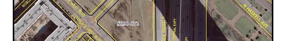
10 CITY PLAN COMMISSION THURSDAY, FEBRUARY 3, 2011 FILE NUMBER: S Subdivision Administrator: Paul Nelson LOCATION: Blackburn Street between N. Central Expressway and Noble Avenue DATE FILED: January 12, 2011ZONING: PD 305, Sub district D-1, west mixed use district CITY COUNCIL DISTRICT: 14 SIZE OF REQUEST: ac. MAPSCO: 35Y APPLICANT/OWNER: JLB Cityplace, LP REQUEST: An application to replat a acre tract of land and part of abandoned Blackburn Street into one acre lot in City Block 984 on Blackburn Street between N. Central Expressway and Noble Avenue SUBDIVISION HISTORY: 1. S was an application contiguous on the north of the present request to create a acre lot in City Block 6/1511 at McKinney Ave. and Noble Ave, the northeast corner. The request was approved on December 21, 2006 and recorded on May 16, STAFF RECOMMENDATION: The request complies with the PD 305, Sub district D-1, west mixed use district requirements; therefore, staff recommends approval subject to compliance with the following conditions: 1. The final plat must conform with all requirements of the Dallas Development Code, Texas Local Government Code, Texas Land Surveying Practices Act and the Rules and Regulations of the Texas Board of Land Surveying. 2. Sustainable Development and Construction, Engineering Division must verify that the plat conforms with water, wastewater and easement requirements under the provisions of Chapter 49 of the Dallas City Code. 3. The final plat must comply with all plans, contracts, ordinances and requirements of the city. 4. The number and location of fire hydrants, and fire apparatus access roads, must comply with the Dallas Fire Code. 5. Any structure new or existing may not extend across new property lines. In addition, any detached non premise sign must be shown on the final plat. 6. Provide a copy of the digital electronic CADD file of the final plat at the time the final plat is submitted for signature by the Chairman of the City Plan Commission in a format that is compatible with the Microstation format. 7. On the final plat, all easement abandonments and ROW abandonments must be by separate instrument and the recording information shown on the face of the plat. A release from the Real Estate Division is required prior to the plat being submitted to the Chairman for signature. 8. The final plat is limited to a maximum of 1 lot. City Plan Commission Date: 2/03/2011 1(a) S /27/2011 2:48:51 PM
11 9. Submit drainage and/or paving plans, prepared by a Professional Engineer, to Sustainable Development and Construction, Engineering Division, Room 200, Oak Cliff Municipal Center. Additions and alterations to the public infrastructure require approval and may require private development contracts with bonds. 10. Detention may be required if the capacity of available outfall is not adequate to carry the developed runoff. 11. On the final plat dedicate 28 feet of right of way from the centerline of Noble Avenue or dedicate a street easement/public utility easement that equals 28 feet from the centerline of Noble Avenue. 12. On the final plat dedicate 30 feet of ROW from the established center line of Blackburn Street. 13. Add a note to the final plat that access to or modification to the US Highway 75 service road requires TXDOT approval. 14. On the final plat show distances/width of right of way across Blackburn Street. 15. On the final plat provide a sidewalk easement along the south property line. 16. On the final plat dedicate the exsiting street easement along the US Highway 75 service road in fee simple. 17. On the final plat all utility easement abandonments must be shown with recording information. 18. On the final plat list utility easements as retained within street abandonments. 19. Engineer shall furnish plans for water and sanitary sewer. Developer shall furnish a contract for water and sanitary sewer. 20. Site plan must be submitted to the Water/Wastewater Section in Room 200 of 320 E. Jefferson Blvd. showing proposed buildings and development. 21. Water/wastewater main extension is required by Private Development Contract. 22. On the final plat label the lot as Lot 1, City Block 2/ Provide a copy of the recording instrument to real estate for the City of Dallas dedication designated in Ord. #24147, Vol , Pg The brick paving shown on the plat may require a license from the City of Dallas. City Plan Commission Date: 2/03/2011 1(b) S /27/2011 2:48:51 PM
12 City Plan Commission Date: 2/03/2011 1(c) S /27/2011 2:48:51 PM


13 ` City Plan Commission Date: 2/03/2011 1(d) S /27/2011 2:48:51 PM
14 City Plan Commission Date: 2/03/2011 1(e) S /27/2011 2:48:51 PM
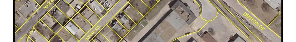
15 CITY PLAN COMMISSION THURSDAY, FEBRUARY 3, 2011 FILE NUMBER: S Subdivision Administrator: Paul Nelson LOCATION: 6100 block of Maple Avenue between Kimsey Street and Bomar Street DATE FILED: January 12, 2011 ZONING: MU-2 CITY COUNCIL DISTRICT: 2 SIZE OF REQUEST: ac. MAPSCO: 34P APPLICANT/OWNER: JLB Maple Partners, LP REQUEST: An application to create a acre lot from a tract of land in City Block 5721 in the 6100 block of Maple Avenue between Kimsey Street and Bomar Street. SUBDIVISION HISTORY: 1. S was an application on property that is part of the current request and was to create a 20 lot Shared Access Area Development from a acre tract of land containing part of City Block 5721 on Maple Avenue northwest of Kimsey Drive. The request was approved on December 7, 2006 but was not recorded and was withdrawn January 11, S was an application on property that is part of the current request and created a 23 lot Shared Access Area Development from a acre tract of land containing part of City Block 5721 on Maple Avenue northwest of Kimsey Drive. The request was approved on December 7, 2006 but was not recorded and was withdrawn January 11, S was an application on property that is part of the current request and was to create a 23 lot Shared Access Area Development from a acre tract of land containing part of City Block 5721 on Maple Avenue northwest of Kimsey Drive. The request was approved on December 7, 2006 but was not recorded and was withdrawn January 11, S was an application on property that is part of the current request and was to create a 20 lot Shared Access Area Development from a acre tract of land and containing part of City Block 5721 on Maple Avenue northwest of Kimsey Drive The request was approved on December 7, 2006 but was not recorded and was withdrawn January 11, S was an application on property south of the present request to create one lot from a tract of land containing acres in City Block D/2370, on 5919 and 5925 Maple Ave. and was approved on November 16, 2006 but has not been recorded. STAFF RECOMMENDATION: The request complies with the MU-2 district requirements; therefore, staff recommends approval subject to compliance with the following conditions: City Plan Commission Date: 2/03/2011 2(a) S /27/2011 2:49:18 PM
16 1. The final plat must conform with all requirements of the Dallas Development Code, Texas Local Government Code, Texas Land Surveying Practices Act and the Rules and Regulations of the Texas Board of Land Surveying. 2. Sustainable Development and Construction, Engineering Division must verify that the plat conforms with water, wastewater and easement requirements under the provisions of Chapter 49 of the Dallas City Code. 3. The final plat must comply with all plans, contracts, ordinances and requirements of the city. 4. The number and location of fire hydrants, and fire apparatus access roads, must comply with the Dallas Fire Code. 5. Any structure new or existing may not extend across new property lines. In addition, any detached non premise sign must be shown on the final plat. 6. Provide a copy of the digital electronic CADD file of the final plat at the time the final plat is submitted for signature by the Chairman of the City Plan Commission in a format that is compatible with the Microstation format. 7. On the final plat, all easement abandonments and ROW abandonments must be by separate instrument and the recording information shown on the face of the plat. A release from the Real Estate Division is required prior to the plat being submitted to the Chairman for signature. 8. The final plat is limited to a maximum of 1 lot. 9. Submit drainage and/or paving plans, prepared by a Professional Engineer, to Sustainable Development and Construction, Engineering Division, Room 200, Oak Cliff Municipal Center. Additions and alterations to the public infrastructure require approval and may require private development contracts with bonds. 10. Detention may be required if the capacity of the available outfall is not adequate to carry the developed runoff. 11. Place a note on the final plat Lot to lot drainage will not be allowed without Engineering Section approval. 12. The site is within the 65 Ldn contour of Dallas Love Field and this noise level may require special construction standards for certain uses per the building code. 13. On the final plat show all additions or tracts within 150 feet of the property boundary. 14. Prior to submittal of the final plat verify buildings along the northeast property line do not encroach upon the plat boundary. 15. On the final plat create an easement by separate instrument for the overhead electric at the west property corner and include the recording information on the face of the final plat. 16. On the final plat show the existing 5 foot alley along the southeast property line. City Plan Commission Date: 2/03/2011 2(b) S /27/2011 2:49:18 PM
17 17. Engineer shall furnish plans for water and sanitary sewer. Developer shall furnish a contract for water and sanitary sewer. A site plan must be submitted to the Water/Wastewater Section in Room 200 of 320 E. Jefferson Blvd. showing proposed buildings and development. 18. Site plan must be submitted to the Water/Wastewater Section in Room 200 of 320 E. Jefferson Blvd. showing proposed buildings and development. 19 Water/wastewater main extension is required by Private Development Contract. 20. On the final plat label the property as Lot 1, City Block A/5721. City Plan Commission Date: 2/03/2011 2(c) S /27/2011 2:49:18 PM
18 City Plan Commission Date: 2/03/2011 2(d) S /27/2011 2:49:18 PM


19 City Plan Commission Date: 2/03/2011 2(e) S /27/2011 2:49:18 PM
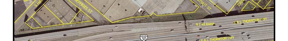
20 CITY PLAN COMMISSION THURSDAY, FEBRUARY 3, 2011 FILE NUMBER: S Subdivision Administrator: Paul Nelson LOCATION: 1610 S. Malcolm X Blvd. at Dawson Dr., north corner DATE FILED: January 13, 2011 ZONING: IM CITY COUNCIL DISTRICT: 2 SIZE OF REQUEST: ac. MAPSCO: 46N APPLICANT/OWNER: CDM City of Hope, Inc./City Square REQUEST: An application to replat a acre tract of land containing all of lots 3, 4, 5, 6, 7, 8, 9, 10 and part of lots 1 and 2 in City Block 6/856 into one lot on property located on 1610 S. Malcolm X Blvd. at Dawson Dr., north corner. SUBDIVISION HISTORY: There has been no recent subdivision activity within close proximity to this request. STAFF RECOMMENDATION: The request complies with the IM district requirements; therefore, staff recommends approval subject to compliance with the following conditions: 1. The final plat must conform with all requirements of the Dallas Development Code, Texas Local Government Code, Texas Land Surveying Practices Act and the Rules and Regulations of the Texas Board of Land Surveying. 2. Sustainable Development and Construction, Engineering Division must verify that the plat conforms with water, wastewater and easement requirements under the provisions of Chapter 49 of the Dallas City Code. 3. The final plat must comply with all plans, contracts, ordinances and requirements of the city. 4. The number and location of fire hydrants, and fire apparatus access roads, must comply with the Dallas Fire Code. 5. Any structure new or existing may not extend across new property lines. In addition, any detached non premise sign must be shown on the final plat. 6. Provide a copy of the digital electronic CADD file of the final plat at the time the final plat is submitted for signature by the Chairman of the City Plan Commission in a format that is compatible with the Microstation format. 7. On the final plat, all easement abandonments and ROW abandonments must be by separate instrument and the recording information shown on the face of the plat. A release from the Real Estate Division is required prior to the plat being submitted to the Chairman for signature. 8. The final plat is limited to a maximum of 1 lot. 9. Submit drainage and/or paving plans, prepared by a Professional Engineer, to Sustainable Development and Construction, Engineering Division, Room 200, Oak Cliff Municipal Center. Additions and alterations to the public infrastructure require approval and may require private development contracts with bonds City Plan Commission Date: 2/03/2011 3(a) S /27/2011 2:49:45 PM
21 10. Detention may be required if the capacity of the available outfall is not adequate to carry the developed runoff. 11. On the final plat dedicate a 15 foot by 15 foot corner clip at Malcolm X Blvd. and Dawson Street and at Dawson Street and Jeffries Street. 12. On the final plat add a note stating: Access or modification to I-30 requires TXDOT approval. 13. The plat may be within the Mill Creek Stormwater Hazard Area. Contact the Engineering Division in Room 200, 320 E. Jefferson Blvd. to determine what, if any, drainage or stormwater management improvements/upgrades must be made to meet the Mill Creek Stormwater Hazard Area guidelines. 14. On the final plat show all recording information for all existing easements within 150 feet of the property boundary. 15. On the final plat show all adjoining property owners. 16. On the final plat call out adjoining property owners in legal description. 17. Engineer shall furnish plans for water and sanitary sewer. Developer shall furnish a contract for water and sanitary sewer. 18. A site plan must be submitted to the Water/Wastewater Section in Room 200 of 320 E. Jefferson Blvd. showing proposed buildings and development. 19. Existing water and/or wastewater easements must be shown and/or increased to conform to current design standards. The minimum DWU easement size is 20 feet for water or wastewater and is 25 feet for an easement having both water and sewer. 20. Water/wastewater main extension is required by Private Development Contract. 21. On the final plat label the lot as Lot 1A, City Block 6/856. City Plan Commission Date: 2/03/2011 3(b) S /27/2011 2:49:45 PM
22 City Plan Commission Date: 2/03/2011 3(c) S /27/2011 2:49:45 PM


23 City Plan Commission Date: 2/03/2011 3(d) S /27/2011 2:49:45 PM
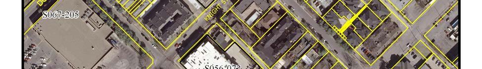
24 CITY PLAN COMMISSION THURSDAY, FEBRUARY 3, 2011 FILE NUMBER: S Subdivision Administrator: Paul Nelson LOCATION: 4019 Bowser Avenue between Knight Street and Throckmorton Street DATE FILED: January 14, 2011 ZONING: PD 193(MF-2) CITY COUNCIL DISTRICT: 14 SIZE OF REQUEST: ac. MAPSCO: 35T APPLICANT/OWNER: Texas Intown Homes, LLC REQUEST: An application to replat all of Lots 15 and 16 in City Block D/1056 into one acre lot located at 4019 Bowser Avenue between Knight Street and Throckmorton Street. SUBDIVISION HISTORY: 1. S is an application east of the present request to replat all of Lots 9 and 10 in City Block 3/1567 into one acre lot located at 3923 and 3931 Holland Avenue at Throckmorton Street, south corner and is scheduled for a hearing on February 3, S was an application southeast of the current request to replat Lots 7 and 8 in City Block 3/1567 into one acre lot on 3930 and 3926 Bowser Avenue at Throckmorton Street. The application was approved on August 23, 2007 but has not been recorded. STAFF RECOMMENDATION: The request complies with the PD 193(MF-2) district requirements; therefore, staff recommends approval subject to compliance with the following conditions: 1. The final plat must conform with all requirements of the Dallas Development Code, Texas Local Government Code, Texas Land Surveying Practices Act and the Rules and Regulations of the Texas Board of Land Surveying. 2. Sustainable Development and Construction, Engineering Division must verify that the plat conforms with water, wastewater and easement requirements under the provisions of Chapter 49 of the Dallas City Code. 3. The final plat must comply with all plans, contracts, ordinances and requirements of the city. 4. The number and location of fire hydrants, and fire apparatus access roads, must comply with the Dallas Fire Code. 5. Any structure new or existing may not extend across new property lines. In addition, any detached non premise sign must be shown on the final plat. 6. Provide a copy of the digital electronic CADD file of the final plat at the time the final plat is submitted for signature by the Chairman of the City Plan Commission in a format that is compatible with the Microstation format. 7. On the final plat, all easement abandonments and ROW abandonments must be by separate instrument and the recording information shown on the face of the City Plan Commission Date: 2/03/2011 4(a) S /27/2011 2:50:13 PM
25 plat. A release from the Real Estate Division is required prior to the plat being submitted to the Chairman for signature. 8. The final plat is limited to a maximum of 1 lot. 9. Provide a detailed lot grading plan prepared by a professional engineer. 10. Place a note on the final plat Lot to lot drainage will not be allowed without Engineering Section approval. 11. Verify that no buildings encroach on or cross existing lot lines prior to submittal of the final plat. 12. A site plan must be submitted to the Water/Wastewater Section in Room 200 of 320 E. Jefferson Blvd. showing proposed buildings and development. 13. On the final plat label the lot as Lot 15A, City Block D/1056. City Plan Commission Date: 2/03/2011 4(b) S /27/2011 2:50:13 PM
26 ` City Plan Commission Date: 2/03/2011 4(c) S /27/2011 2:50:13 PM


27 City Plan Commission Date: 2/03/2011 4(d) S /27/2011 2:50:13 PM
28 CITY PLAN COMMISSION THURSDAY, FEBRUARY 3, 2011 FILE NUMBER: S Subdivision Administrator: Paul Nelson LOCATION: 3923 and 3931 Holland Avenue at Throckmorton Street, south corner DATE FILED: January 14, 2011 ZONING: PD 193(MF-2) CITY COUNCIL DISTRICT: 14 SIZE OF REQUEST: ac. MAPSCO: 35T APPLICANT/OWNER: Texas Intown Homes, LLC REQUEST: An application to replat all of Lots 9 and 10 in City Block 3/1567 into one acre lot located at 3923 and 3931 Holland Avenue at Throckmorton Street, south corner. SUBDIVISION HISTORY: 1. S is an application northwest of this request to replat all of Lots 15 and 16 in City Block D/1056 into one acre lot located at 4019 Bowser Avenue between Knight Street and Throckmorton Street and is scheduled for a hearing on February 3, S was an application adjacent on the northwest across the alley to replat Lots 7 and 8 in City Block 3/1567 into one acre lot on 3930 and 3926 Bowser Avenue at Throckmorton Street. The application was approved on August 23, 2007 but has not been recorded. STAFF RECOMMENDATION: The request complies with the PD 193(MF-2) district requirements; therefore, staff recommends approval subject to compliance with the following conditions: 1. The final plat must conform with all requirements of the Dallas Development Code, Texas Local Government Code, Texas Land Surveying Practices Act and the Rules and Regulations of the Texas Board of Land Surveying. 2. Sustainable Development and Construction, Engineering Division must verify that the plat conforms with water, wastewater and easement requirements under the provisions of Chapter 49 of the Dallas City Code. 3. The final plat must comply with all plans, contracts, ordinances and requirements of the city. 4. The number and location of fire hydrants, and fire apparatus access roads, must comply with the Dallas Fire Code. 5. Any structure new or existing may not extend across new property lines. In addition, any detached non premise sign must be shown on the final plat. 6. Provide a copy of the digital electronic CADD file of the final plat at the time the final plat is submitted for signature by the Chairman of the City Plan Commission in a format that is compatible with the Microstation format. 7. On the final plat, all easement and ROW abandonments must be by separate instrument and the recording information shown on the face of the plat. A release City Plan Commission Date: 2/03/2011 5(a) S /27/2011 2:50:40 PM
29 from the Real Estate Division is required prior to the plat being submitted to the Chairman for signature. 8. The final plat is limited to a maximum of 1 lot. 9. Provide a detailed lot grading plan prepared by a Professional Engineer to Sustainable Development and Construction, Engineering Division, Room 200, Oak Cliff Municipal Center. 10. Place a note on the final plat Lot to lot drainage will not be allowed without Engineering Section approval. 11. On the final plat dedicate a 10 foot X 10 foot corner clip at Holland Avenue and Throckmorton Street. 12. On the final plat dedicate a 15 foot X 15 foot corner clip at Throckmorton Street and the alley. 13. The owner(s) of the property at the time of the signing of the final plat must sign the final plat. 14. A site plan must be submitted to the Water/Wastewater Section in Room 200 of 320 E. Jefferson Blvd. showing proposed buildings and development. 15. On the final plat label the lot as Lot 9A, City Block 3/1567. City Plan Commission Date: 2/03/2011 5(b) S /27/2011 2:50:40 PM
30 City Plan Commission Date: 2/03/2011 5(c) S /27/2011 2:50:40 PM


31 City Plan Commission Date: 2/03/2011 5(d) S /27/2011 2:50:40 PM
32 CITY PLAN COMMISSION THURSDAY, FEBRUARY 3, 2011 FILE NUMBER: S Subdivision Administrator: Paul Nelson LOCATION: 2803 thru 2811 Shelby Avenue and 3910 Congress Avenue DATE FILED: January 14, 2011 ZONING: PD 193(MF-3) CITY COUNCIL DISTRICT: 14 SIZE OF REQUEST: ac. MAPSCO: 35W APPLICANT/OWNER: Texas Intown Homes, LLC REQUEST: An application to replat all of Lots 1, 2 and part of Lot 3 in City Block 2/1336 into one acre lot located at 2803 thru 2811 Shelby Avenue and 3910 Congress. SUBDIVISION HISTORY: There has been no recent platting activity within close proximity to this request. STAFF RECOMMENDATION: The request complies with the PD 193(MF-3) district requirements; therefore, staff recommends approval subject to compliance with the following conditions: 1. The final plat must conform with all requirements of the Dallas Development Code, Texas Local Government Code, Texas Land Surveying Practices Act and the Rules and Regulations of the Texas Board of Land Surveying. 2. Sustainable Development and Construction, Engineering Division must verify that the plat conforms with water, wastewater and easement requirements under the provisions of Chapter 49 of the Dallas City Code. 3. The final plat must comply with all plans, contracts, ordinances and requirements of the city. 4. The number and location of fire hydrants, and fire apparatus access roads, must comply with the Dallas Fire Code. 5. Any structure new or existing may not extend across new property lines. In addition, any detached non premise sign must be shown on the final plat. 6. Provide a copy of the digital electronic CADD file of the final plat at the time the final plat is submitted for signature by the Chairman of the City Plan Commission in a format that is compatible with the Microstation format. 7. On the final plat, all easement and ROW abandonments must be by separate instrument and the recording information shown on the face of the plat. A release from the Real Estate Division is required prior to the plat being submitted to the Chairman for signature. 8. The final plat is limited to a maximum of 1 lot. 9. Provide a detailed lot grading plan prepared by a Professional Engineer to Sustainable Development and Construction, Engineering Division, Room 200, Oak Cliff Municipal Center. 10. Place a note on the final plat Lot to lot drainage will not be allowed without Engineering Section approval. City Plan Commission Date: 2/03/2011 6(a) S /27/2011 2:51:08 PM
33 11. On the final plat change the addition name. 12. On the final plat show all additions or tracts of land within 150 feet the property. 13. The owner(s) of the property at the time of the signing of the final plat must sign the final plat. 14. Engineer shall furnish plans for water and sanitary sewer. Developer shall furnish a contract for water and sanitary sewer. 15. A site plan must be submitted to the Water/Wastewater Section in Room 200 of 320 E. Jefferson Blvd. showing proposed buildings and development. 16. Water/wastewater main extension is required by Private Development Contract. 17. On the final plat label the lot as Lot 1A, City Block 2/1336. City Plan Commission Date: 2/03/2011 6(b) S /27/2011 2:51:08 PM
34 City Plan Commission Date: 2/03/2011 6(c) S /27/2011 2:51:08 PM


35 City Plan Commission Date: 2/03/2011 6(d) S /27/2011 2:51:08 PM
36 CITY PLAN COMMISSION THURSDAY, FEBRUARY 3, 2011 FILE NUMBER: S Subdivision Administrator: Paul Nelson LOCATION: 4001 N. Hall Street at Throckmorton Street, west corner DATE FILED: January 14, 2011 ZONING: PD 193(MF-2) CITY COUNCIL DISTRICT: 14 SIZE OF REQUEST: ac. MAPSCO: 35W APPLICANT/OWNER: Texas Intown Homes, LLC REQUEST: An application to replat all of Lot 18 in City Block A/1324 into five lots ranging in size from 1,536 square feet to 2,504 square feet in size located at 4001 N. Hall Street at Throckmorton Street, west corner. SUBDIVISION HISTORY: There has been no recent platting activity within close proximity to this request. STAFF RECOMMENDATION: The request complies with the PD 193(MF-2) district requirements; therefore, staff recommends approval subject to compliance with the following conditions: 1. The final plat must conform with all requirements of the Dallas Development Code, Texas Local Government Code, Texas Land Surveying Practices Act and the Rules and Regulations of the Texas Board of Land Surveying. 2. Sustainable Development and Construction, Engineering Division must verify that the plat conforms with water, wastewater and easement requirements under the provisions of Chapter 49 of the Dallas City Code. 3. The final plat must comply with all plans, contracts, ordinances and requirements of the city. 4. The number and location of fire hydrants, and fire apparatus access roads, must comply with the Dallas Fire Code. 5. Any structure new or existing may not extend across new property lines. In addition, any detached non premise sign must be shown on the final plat. 6. Provide a copy of the digital electronic CADD file of the final plat at the time the final plat is submitted for signature by the Chairman of the City Plan Commission in a format that is compatible with the Microstation format. 7. On the final plat, all easement abandonments and ROW abandonments must be by separate instrument and the recording information shown on the face of the plat. A release from the Real Estate Division is required prior to the plat being submitted to the Chairman for signature. 8. The final plat is limited to a maximum of 5 lots. 9. Provide a detailed lot grading plan prepared by a Professional Engineer to Sustainable Development and Construction, Engineering Division, Room 200, Oak Cliff Municipal Center. City Plan Commission Date: 2/03/2011 7(a) S /27/2011 2:51:36 PM
37 10. Place a note on the final plat Lot to lot drainage will not be allowed without Engineering Section approval. 11. On the final plat dedicate a 15 foot by 15 foot alley sight easement at Throckmorton Street and the alley. 12. On the final plat dedicate a 10 foot by 10 foot corner clip at Hall Street and Throckmorton Street. 13. On the final plat dedicate 7.5 feet of ROW from the established centerline of the existing alley. 14. On the final plat show all additions or tracts of land within 150 feet the property. 15. On the final plat show the current ownership of abandoned Strange Street. 16. Engineer shall furnish plans for water and sanitary sewer. Developer shall furnish a contract for water and sanitary sewer. 17. A site plan must be submitted to the Water/Wastewater Section in Room 200 of 320 E. Jefferson Blvd. showing proposed buildings and development. 18. Water/wastewater main extension is required by Private Development Contract. 19. On the final plat label the lots as Lots 18A, 18B, 18C, 18D and 18E, City Block A/1324. City Plan Commission Date: 2/03/2011 7(b) S /27/2011 2:51:36 PM
38 City Plan Commission Date: 2/03/2011 7(c) S /27/2011 2:51:36 PM


39 City Plan Commission Date: 2/03/2011 7(d) S /27/2011 2:51:36 PM
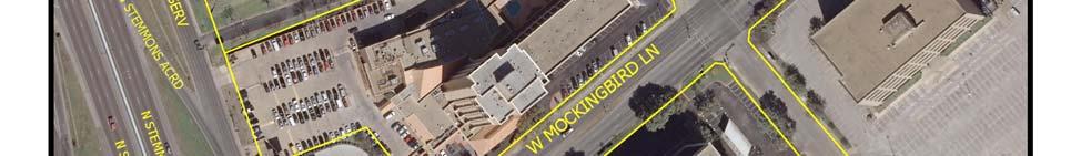
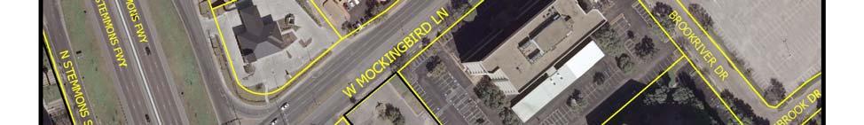
40 CITY PLAN COMMISSION THURSDAY, FEBRUARY 3, 2011 FILE NUMBER: S Subdivision Administrator: Paul Nelson LOCATION: Mockingbird Lane and Stemmons Freeway DATE FILED: January 14, 2011 ZONING: MU-3 CITY COUNCIL DISTRICT: 2 SIZE OF REQUEST: ac. MAPSCO: 33U APPLICANT/OWNER: Stemmons Plaza; Bobby Cox Companies REQUEST: An application to create one acre lot, one acre lot and one acre lot from a acre tract of land in City Block 7940 on Mockingbird Lane and Stemmons Freeway. SUBDIVISION HISTORY: There has been no recent platting activity within close proximity to this request. STAFF RECOMMENDATION: The request complies with the MU-3 district requirements; therefore, staff recommends approval subject to compliance with the following conditions: 1. The final plat must conform with all requirements of the Dallas Development Code, Texas Local Government Code, Texas Land Surveying Practices Act and the Rules and Regulations of the Texas Board of Land Surveying. 2. Sustainable Development and Construction, Engineering Division must verify that the plat conforms with water, wastewater and easement requirements under the provisions of Chapter 49 of the Dallas City Code. 3. The final plat must comply with all plans, contracts, ordinances and requirements of the city. 4. The number and location of fire hydrants, and fire apparatus access roads, must comply with the Dallas Fire Code. 5. Any structure new or existing may not extend across new property lines. In addition, any detached non premise sign must be shown on the final plat. 6. Provide a copy of the digital electronic CADD file of the final plat at the time the final plat is submitted for signature by the Chairman of the City Plan Commission in a format that is compatible with the Microstation format. 7. On the final plat, all easement and ROW abandonments must be by separate instrument and the recording information shown on the face of the plat. A release from the Real Estate Division is required prior to the plat being submitted to the Chairman for signature. 8. The final plat is limited to a maximum of 3 lots. 9. Submit drainage and/or paving plans, prepared by a Professional Engineer, to Sustainable Development and Construction, Engineering Division, Room 200, Oak Cliff Municipal Center. Additions and alterations to the public infrastructure require approval and may require private development contracts with bonds. City Plan Commission Date: 2/03/2011 8(a) S /27/2011 2:52:03 PM
41 10. Place a note on the final plat Lot to lot drainage will not be allowed without Engineering Section approval. 11. Specify minimum fill and minimum finished floor elevations. 12. Provide information regarding fill permit or floodplain alteration permit if such permit is applied for. 13. The property is in the Record Crossing Sump (WSE 405.8). All Construction for any proposed development must be above feet in elevation. For the areas where the existing elevation is below feet and development is proposed, there must be a fill permit applied for and approved by the Public Works and Transportation Department and the Minimum Finished Floor elevation will have to be established thru fill permit process. 14. On the final plat add the following note: Access or modification to I-35E requires TXDOT approval. 15. On the final plat verify the ROW width of Mockingbird Lane. 16. Engineer shall furnish plans for water and sanitary sewer. Developer shall furnish a contract for water and sanitary sewer. 17. A site plan must be submitted to the Water/Wastewater Section in Room 200 of 320 E. Jefferson Blvd. showing proposed buildings and development. 18. Water/wastewater main extension is required by Private Development Contract. 19. Fire hydrant(s) are required to be provided by Private Development Contract. 20. On the final plat label the lots as Lots 2, 3 and 4 in City Block L/7940. City Plan Commission Date: 2/03/2011 8(b) S /27/2011 2:52:03 PM
42 City Plan Commission Date: 2/03/2011 8(c) S /27/2011 2:52:03 PM


43 City Plan Commission Date: 2/03/2011 8(d) S /27/2011 2:52:03 PM
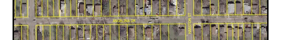
44 CITY PLAN COMMISSION THURSDAY, FEBRUARY 3, 2011 FILE NUMBER: S Subdivision Administrator: Paul Nelson LOCATION: 1917, 1919 and 1923 Bayside St., between Harston St. and Puget St. DATE FILED: January 6, 2011 ZONING: R-5(A) CITY COUNCIL DISTRICT: 3 SIZE OF REQUEST: ac. MAPSCO: 44J APPLICANT/OWNER: Community Care Fellowship REQUEST: An application to replat a acre tract of land containing all of Lots 1, 2 and 3 in City Block 15/7130 into one lot at 1917, 1919 and 1923 Bayside Street between Harston Street and Puget Street. SUBDIVISION HISTORY: There has been no recent subdivision activity within close proximity to this request. DATE NOTICES SENT: January 13, 2011 STAFF RECOMMENDATION: Section 51A-8.503(a) indicates that Lots must conform in width, depth, and area to the pattern already established in the adjacent areas, having due regard to the character of the area, its particular suitability for development, and taking into consideration the natural topography of the ground, drainage, wastewater facilities, and the proposed layout of streets The request complies with the R-5(A) district regulations; however, the new lot is not consistent in size with the existing lot sizes or lot pattern of the area; therefore, staff recommends denial of the request. However, should the request be approved the approval should be subject to compliance with the following conditions: 1. The final plat must conform with all requirements of the Dallas Development Code, Texas Local Government Code, Texas Land Surveying Practices Act and the Rules and Regulations of the Texas Board of Land Surveying. 2. Sustainable Development and Construction, Engineering Division must verify that the plat conforms with water, wastewater and easement requirements under the provisions of Chapter 49 of the Dallas City Code. 3. The final plat must comply with all plans, contracts, ordinances and requirements of the City. 4. The number and location of fire hydrants, and fire apparatus access roads, must comply with the Dallas Fire Code. 5. Any structure new or existing may not extend across new property lines. In addition, any detached non premise sign must be shown on the final plat. 6. Provide a copy of the digital electronic CADD file of the final plat at the time the final plat is submitted for signature by the Chairman of the City Plan Commission in a format that is compatible with the Microstation format. 7. On the final plat, all easement and ROW abandonments must be by separate instrument and the recording information shown on the face of the plat. A release City Plan Commission Date: 02/03/2011 9(a) S /27/2011 2:52:30 PM
45 from the Real Estate Division is required prior to the plat being submitted to the Chairman for signature. 8. The final plat is limited to a maximum of 1 lot. 9. Place a note on the final plat Lot to lot drainage will not be allowed without Engineering Section approval. 10. Provide a detailed lot grading plan prepared by a Professional Engineer to Sustainable Development and Construction, Engineering Division, Room 200, Oak Cliff Municipal Center. 11. The subject site is located within the Pavaho Sump (WSE feet). All construction for any proposed development must be above feet elevation. For the areas where the existing elevation is below feet, if any improvement is proposed, there must be a fill permit applied for and approved by Public Works and Transportation Department and Minimum Finish Floor elevation for those areas will have to be established thru the process. 12. On the final plat show easements by location and recording information for overhead electric lines. 13. A site plan must be submitted to the Water/Wastewater Section in Room 200 of 320 E. Jefferson Blvd. showing proposed buildings and development. 14. A Fire Protection Certificate must be signed and approved by the Building Inspection Chief Plans Examiner (or assigned representative) in Room 105 of the Oak Cliff Municipal Center, 320 E. Jefferson Blvd. and must be submitted to the Manager of Water and Sewer Services, Engineering Division, in Room 200, 320 E. Jefferson Blvd. prior to submittal of the final plat for signature by the Chairperson of the City Plan Commission. A signed Fire Protection Certificate is also required prior to the approval of an Early Release Building Permit application. 15. Water main extension may be required by Private Development Contract. 16. On the final plat label the property as Lot 30A, City Block 15/7130. City Plan Commission Date: 02/03/2011 9(b) S /27/2011 2:52:30 PM
46 City Plan Commission Date: 02/03/2011 9(c) S /27/2011 2:52:30 PM


47 City Plan Commission Date: 02/03/2011 9(d) S /27/2011 2:52:30 PM
48 City Plan Commission Date: 02/03/2011 9(e) S /27/2011 2:52:30 PM
49 City Plan Commission Date: 02/03/2011 9(f) S /27/2011 2:52:30 PM
50 City Plan Commission Date: 02/03/2011 9(g) S /27/2011 2:52:30 PM
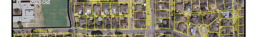
51 CITY PLAN COMMISSION THURSDAY, FEBRUARY 3, 2011 FILE NUMBER: S Subdivision Administrator: Paul Nelson LOCATION: between Webb Chapel Rd. and Pensive Dr. south of Merrell Rd. DATE FILED: January 7, 2011 ZONING: R-10(A) CITY COUNCIL DISTRICT: 13 SIZE OF REQUEST: ac. MAPSCO: 23L APPLICANT/OWNER: Dallas Independent School District REQUEST: An application to replat an acre tract of land into 1 lot and containing all of Lots 1A, 1B, 1C, 1D, 2A and the remainder of Lots 1 and 2 in City Block N/6431 and Assembly Court to be abandoned on property between Webb Chapel Rd. and Pensive Dr. south of Merrell Rd. SUBDIVISION HISTORY: There has been no recent subdivision activity within close proximity to this request. DATE NOTICES SENT: January 14, 2011 STAFF RECOMMENDATION: The request complies with the R-10(A) district regulations, therefore, staff recommends approval subject to compliance with the following conditions: 1. The final plat must conform with all requirements of the Dallas Development Code, Texas Local Government Code, Texas Land Surveying Practices Act and the Rules and Regulations of the Texas Board of Land Surveying. 2. Sustainable Development and Construction, Engineering Division must verify that the plat conforms with water, wastewater and easement requirements under the provisions of Chapter 49 of the Dallas City Code. 3. The final plat must comply with all plans, contracts, ordinances and requirements of the City. 4. The number and location of fire hydrants, and fire apparatus access roads, must comply with the Dallas Fire Code. 5. Any structure new or existing may not extend across new property lines. In addition, any detached non premise sign must be shown on the final plat. 6. Provide a copy of the digital electronic CADD file of the final plat at the time the final plat is submitted for signature by the Chairman of the City Plan Commission in a format that is compatible with the Microstation format. 7. On the final plat, all easement and ROW abandonments must be by separate instrument and the recording information shown on the face of the plat. A release from the Real Estate Division is required prior to the plat being submitted to the Chairman for signature. 8. The final plat is limited to a maximum of 1 lot. 9. Submit drainage and/or paving plans, prepared by a Professional Engineer, to Sustainable Development and Construction, Engineering Division, Room 200, City Plan Commission Date: 02/03/ (a) S /27/2011 2:47:43 PM
52 Oak Cliff Municipal Center. Additions and alterations to the public infrastructure require approval and may require private development contracts with bonds. 10. Detention may be required if the capacity of the available outfall is not adequate to carry the developed runoff. 11. On the final plat dedicate 7.5 feet of ROW from the established centerline of the existing alley. 12. On the final plat dedicate a 15 foot X 15 foot alley sight easement at the intersection of Pensive Drive and the alley. 13. Prior to submittal of the final plat for the Chairman s signature resolve the issue of City of Dallas property shown as Tract B (vol. 572, pg. 126) or have the City of Dallas also sign the final plat. 14. Engineer shall furnish plans for water and sanitary sewer. Developer shall furnish a contract for water and sanitary sewer. 15. A site plan must be submitted to the Water/Wastewater Section in Room 200 of 320 E. Jefferson Blvd. showing proposed buildings and development 16. Water/wastewater main extension is required by Private Development Contract. 17. Fire hydrant(s) required by Private Development Contract. 18. On the final plat label the property as Lot 1E, City Block N/ On the final plat confirm if City of Dallas Tract B dedicated by Vol. 572, pg.126 is to be abandoned and if so include recording information. Confirm if 20 foot firelane easement dedicated by Vol , Pg is to be abandoned. 20. All abandonments must be processed through the Real Estate Division. City Plan Commission Date: 02/03/ (b) S /27/2011 2:47:43 PM
53 City Plan Commission Date: 02/03/ (c) S /27/2011 2:47:43 PM


54 City Plan Commission Date: 02/03/ (d) S /27/2011 2:47:43 PM
 S101-034 1/27/2011")
55 City Plan Commission Date: 02/03/ (e) S /27/2011 2:47:43 PM
56 City Plan Commission Date: 02/03/ (f) S /27/2011 2:47:43 PM
57 City Plan Commission Date: 02/03/ (g) S /27/2011 2:47:43 PM
58 City Plan Commission Date: 02/03/ (h) S /27/2011 2:47:43 PM
59 CITY PLAN COMMISSION THURSDAY, FEBRUARY 3, 2011 FILE NUMBER: S Subdivision Administrator: Paul Nelson LOCATION: 9762 Audobon Place DATE FILED: January 12, 2011 ZONING: R-1ac.(A) CITY COUNCIL DISTRICT: 13 SIZE OF REQUEST: ac. MAPSCO: 24R APPLICANT/OWNER: Randy and Nancy Best REQUEST: An application to replat all of Lot 4 and part of Lot 5 in City Block 14/5587 of the Subdivision of Block 14, Sunnybrook Estates Addition into one acre lot fronting feet on 9762 Audubon Place. SUBDIVISION HISTORY: 1. S was an application to replat Lots 11 and 12 in City Block 14/5587 of Sunnybrook Estates, also known as 9727 and 9707 Audubon Place, into one 3.18 acre lot located at the intersection of Park Lane and Audubon Place, northwest corner. The request was approved on October 16, 2008 and recorded on August 14, S was an application to replat all of Lots 8A, 8B, and 8C, of the Lloyd Subdivision, in City Block 13/5586, into one 4.14 acre lot at the southwest corner of Sunnybrook Lane at Park Lane. Approved April 24, 2008, but has not been recorded. DATES NOTICES SENT: January 18, STAFF RECOMMENDATION: The request complies with the R-1ac.(A) district regulations and consistent with the established lot pattern on the north, east and south of this request; therefore, staff recommends approval subject to compliance with the following conditions: 1. The final plat must conform with all requirements of the Dallas Development Code, Texas Local Government Code, Texas Land Surveying Practices Act and the Rules and Regulations of the Texas Board of Land Surveying. 2. Sustainable Development and Construction, Engineering Division must verify that the plat conforms with water, wastewater and easement requirements under the provisions of Chapter 49 of the Dallas City Code. 3. The final plat must comply with all plans, contracts, ordinances and requirements of the City. 4. The number and location of fire hydrants, and fire apparatus access roads, must comply with the Dallas Fire Code. 5. Any structure new or existing may not extend across new property lines. In addition, any detached non premise sign must be shown on the final plat. City Plan Commission Date: 02/03/ (a) S /27/2011 2:48:18 PM
60 6. Provide a copy of the digital electronic CADD file of the final plat at the time the final plat is submitted for signature by the Chairman of the City Plan Commission in a format that is compatible with the Microstation format. 7. On the final plat, all easement and ROW abandonments must be by separate instrument and the recording information shown on the face of the plat. A release from the Real Estate Division is required prior to the plat being submitted to the Chairman for signature. 8. The final plat is limited to a maximum of 1 lot. 9. Submit drainage and/or paving plans, prepared by a Professional Engineer, to Sustainable Development and Construction, Engineering Division, Room 200, Oak Cliff Municipal Center. Additions and alterations to the public infrastructure require approval and may require private development contracts with bonds. 10. Place a note on the final plat Lot to lot drainage will not be allowed without Engineering Section approval. 11. On the final plat dedicate 26.5 feet of ROW from the established centerline, or dedicate a street easement, or Public Utility and Sidewalk Easement to equal 26.5 feet from the established centerline of Audubon Place. 12. On the final plat label the property as Lot 4A, City Block 14/5587. City Plan Commission Date: 02/03/ (b) S /27/2011 2:48:18 PM
61 City Plan Commission Date: 02/03/ (c) S /27/2011 2:48:18 PM


62 City Plan Commission Date: 02/03/ (d) S /27/2011 2:48:18 PM
63 City Plan Commission Date: 02/03/ (e) S /27/2011 2:48:18 PM
64 City Plan Commission Date: 02/03/ (f) S /27/2011 2:48:18 PM
65 CITY PLAN COMMISSION THURSDAY, FEBRUARY 3, 2011 Planner: Richard E. Brown FILE NUMBER: M DATE FILED: November 10, 2010 LOCATION: West Line of Edgefield Avenue between Brooklyn Avenue and Twelfth Street COUNCIL DISTRICT: 1 MAPSCO: 54 E, F SIZE OF REQUEST: Approx. 9.6 Acres CENSUS TRACT: 52 APPLICANT/OWNER: Dallas Independent School District REPRESENTATIVE: Karl Crawley MISCELLANEOUS DOCKET ITEM Minor Amendment for Development Plan and Landscape Plan On February 22, 1989, the City Council passed Ordinance No which established Planned Development District No. 306 for a Public school and Community service center on property at the above location. The PDD was subsequently amended by Ordiance No The property owner has requested consideration of a minor amendment to the development plan to provide for revised dumpster locations and on-site surface parking areas. The landscape plan is being amended to provide for consistency with these requested improvements. The requested minor amendment complies with the requirements for consideration of such and does not impact any other provisions of the ordinance governing the property. STAFF RECOMMENDATION: Approval 1
66 2
67 3 Proposed Development Plan
68 4 Proposed Landscape Plan
69 5 Existing Development Plan
70 6
71 Page 1 of 3 12/6/2010 Notification List of Property Owners M Property Owners Notified Label # Address Owner MONTCLAIR ELLIOTT ANN MONTCLAIR Dallas ISD EDGEFIELD WOY MITZI EDGEFIELD CROW REED C & LEVIN ALLISON I EDGEFIELD ROSALES MANUEL WINDOMERE ALMAZAN ROBERTO M WINDOMERE DELAMETTER JACK II EDGEFIELD ECKART JAMES & VANESSA MOLINA EDGEFIELD GALVAN JOSE G EDGEFIELD SALDIVAR ALFREDO EDGEFIELD RODRIGUEZ MANUEL & CYNTHIA EDGEFIELD HOWARD ROBERT L EDGEFIELD MONTEMAYOR ANSELMO EDGEFIELD ALDRED FAMILY 2 LIMITED PARTNERSHIP THE EDGEFIELD MARQUEZ JUAN V & ALICIA EDGEFIELD MEDINA ANTONIO O & ELIZABETH EDGEFIELD KEITH KOREY LANE EDGEFIELD RODRIGUEZ VIRGINIA EDGEFIELD CORDERO JUAN & PAULA EDGEFIELD TREJO XOCHITL R DBA DIAMANTE HOMES INC EDGEFIELD YBARRA BENITA RANGEL CLINTON LAMURE STEPHEN J & DANA C S CLINTON OLALDE LUIS & SOCORRO OLALDE CLINTON CABRERA JUANA & LEONARDO PARRA CLINTON RUBIO ANDREA & CLINTON VILLAGOMEZ SALVADOR & ESTER Monday, December 06,
72 Label # Address Owner EDGEFIELD FISCAL JUAN MARTIN EDGEFIELD CONTRERAS FRANCISCO M & GUADALUPE R EDGEFIELD SANTIAGO JULIO C & AZUCENA GARCIA EDGEFIELD CONTRERAS JUAN EDGEFIELD HUD % PPTY DISP BRANCH EDGEFIELD AGUINAGA LUISA EDGEFIELD JC LEASING LLP EDGEFIELD MILES RONALD H EDGEFIELD RAMIREZ LORENZO EDGEFIELD LULAC NATL EDUCATION SERVICE CENTERS INC EDGEFIELD HASH LONNIE WATSON JR WINDOMERE THOMAS MARK M & CANDICE WINDOMERE LARA IGNACIO H & ELIZABETH M WINDOMERE MARTIN SHARHONDA WINDOMERE CITY BANK OF TEXAS MONTCLAIR ELLIOTT ANN MONTCLAIR ELLIS ALLISON L & WEI MENG CHEE TR MONTCLAIR RIVERA ALEJANDRINA L MRS MONTCLAIR TART DAVID & CANDYCE TH ESPINOZA LUCAS J & IGNACIO ESPINOZA TH ISBELL FAMILY LTD PS TH MARTINEZ MARIA WINDOMERE PEREZ AGUSTIN JR PAGE REYES FRANCES LOUISE & PAGE VILLARREAL JUAN CARLOS PAGE ERRISURIZ MARLENE & NELLYDA ERRISURIEZ PAGE STOKER BOBBIE PAGE MEDINA ANGEL & FLORINDA MEDINA WINDOMERE MENDOZA MAXIMINO & MARIA WINDOMERE MACIAS JUANA GONZALEZ & WINDOMERE GONZALEZ MACARIA Monday, December 06,
73 Label # Address Owner WINDOMERE ESPARZA EDUARDO & MARIA CAROLINA EDGEFIELD ZAYAS LARRY JESUS & EDGEFIELD ARIAS MARGARITA R EDGEFIELD SNIDOW BARRY G & EDGEFIELD ROMERO FRANCISCA MONTCLAIR SWART ROBERT JEFFREY & DARLENE SWART MONTCLAIR ZARRELLA JOHN & NANCY MONTCLAIR AGUIRRE EDMUNDO VALENTINA MONTCLAIR MARTINEZ LAURA WINDOMERE ALBARRAN MARIA C WINDOMERE COUCH PATRICIA ANNETTE WINDOMERE AVILA LORENZO H WINDOMERE JESTER PHILLIP SHORTRIDGE Monday, December 06,
74 CITY PLAN COMMISSION THURSDAY, FEBRUARY 3, 2011 Planner: Olga Torres-Holyoak FILE NUMBER: D DATE FILED: November 29, 2010 LOCATION: On the northeast side of Northwest Highway, west of Skillman Road. COUNCIL DISTRICT: 9 MAPSCO: 26 Y, Z SIZE OF REQUEST: Approx acres CENSUS TRACT: MISCELLANEOUS DOCKET ITEM Owner: Applicant: Representative: TC Timbercreek Associates, L.P. Whataburger Restaurants, LP Janet Reid Development Plan: On May 10, 2007, the City Council passed Ordinance No which established Planned Development District No. 742 on property located at the northeast line of Northwest Highway, west of Skillman Road. The property is located in Zone 1, Lot 5A within Planned Development District No The zoning was granted as a conceptual planned development district and requires City Plan Commission approval of a development plan for each phase of development prior to the issuance of a building permit. In conjunction with the above requirement, the attached development plan has been submitted for Commission s consideration. The plan provides for the development of a restaurant with drive-in or drive-through service. The proposed building is 3,218 square feet. STAFF RECOMMENDATION: Approval 1
75 List of Applicant, Owner and Representative Partners for T.C. Timbercreek S Denton Walker III Michael S. Duffy Robert Scully Scott A Dyche John Stirek T Christopher Roth J Christopher Kirk Matthew J, Nickels III Arlin Gaffner Matthew Khourie Mark C. Allyn Carrie A. Shelton Rebecca M. Savino CEO Director Senior VP Senior VP Executive VP Executive VP Director Executive VP Treasurer Executive VP Executive VP Secretary Asst. Secretary 2
76 3
77 EXISTING CONCEPTUAL PLAN 4
78 PROPOSED DEVELOPMENT PLAN 5
79 CITY PLAN COMMISSION THURSDAY, FEBRUARY 3, 2011 Planner: Olga Torres-Holyoak FILE NUMBER: D DATE FILED: December 13, 2010 LOCATION: On the northeast side of Northwest Highway, west of Skillman Road. COUNCIL DISTRICT: 9 MAPSCO: 26 Y, Z SIZE OF REQUEST: Approx acres CENSUS TRACT: MISCELLANEOUS DOCKET ITEM Owner/ Applicant: Representative: TC Timbercreek Associates, L.P. Robert Brandt Development Plan & Landscape Plan: On May 10, 2007, the City Council passed Ordinance No which established Planned Development District No. 742 on property located at the northeast line of Northwest Highway, west of Skillman Road. The property is located in Zone 1, Lot 3 within Planned Development District No The zoning was granted as a conceptual planned development district and requires City Plan Commission approval of a development plan for each phase of development prior to the issuance of a building permit. In conjunction with the above requirement, the attached development plan has been submitted for Commission s consideration. The plan provides for the development of a 20,800 square feet building for retail uses. STAFF RECOMMENDATION: Approval 1
80 List of Applicant, Owner and Representative Partners for T.C. Timbercreek S Denton Walker III Michael S. Duffy Robert Scully Scott A Dyche John Stirek T Christopher Roth J Christopher Kirk Matthew J, Nickels III Arlin Gaffner Matthew Khourie Mark C. Allyn Carrie A. Shelton Rebecca M. Savino CEO Director Senior VP Senior VP Executive VP Executive VP Director Executive VP Treasurer Executive VP Executive VP Secretary Asst. Secretary 2
81 EXISTING CONCEPTUAL PLAN 3
82 PROPOSED DEVELOPMENT PLAN 4
83 CITY PLAN COMMISSION THURSDAY, FEBRUARY 3, 2011 Planner: Olga Torres-Holyoak FILE NUMBER: D DATE FILED: December 13, 2010 LOCATION: On the northeast side of Northwest Highway, west of Skillman Road. COUNCIL DISTRICT: 9 MAPSCO: 26 Y, Z SIZE OF REQUEST: Approx acres CENSUS TRACT: MISCELLANEOUS DOCKET ITEM Owner/Applicant: Representative: TC Timbercreek Associates, L.P. Robert Brandt Development Plan: On May 10, 2007, the City Council passed Ordinance No which established Planned Development District No. 742 on property located at the northeast line of Northwest Highway, west of Skillman Road. The property is located in Zone 1, Lot 7 within Planned Development District No The zoning was granted as a conceptual planned development district and requires City Plan Commission approval of a development plan for each phase of development prior to the issuance of a building permit. In conjunction with the above requirement, the attached development plan has been submitted for Commission s consideration. The plan provides for the development of a 20,800 square feet building for retail uses and a restaurant with drive-in or drive through service. STAFF RECOMMENDATION: Approval 1
84 List of Applicant, Owner and Representative Partners for T.C. Timbercreek S Denton Walker III Michael S. Duffy Robert Scully Scott A Dyche John Stirek T Christopher Roth J Christopher Kirk Matthew J, Nickels III Arlin Gaffner Matthew Khourie Mark C. Allyn Carrie A. Shelton Rebecca M. Savino CEO Director Senior VP Senior VP Executive VP Executive VP Director Executive VP Treasurer Executive VP Executive VP Secretary Asst. Secretary 2
85 EXISTING CONCEPTUAL PLAN 3
86 PROPOSED DEVELOPMENT PLAN 4
87 CITY PLAN COMMISSION THURSDAY, FEBRUARY 3, 2011 Planner: Olga Torres-Holyoak FILE NUMBER: D DATE FILED: December 13, 2010 LOCATION: On the northeast side of Northwest Highway, west of Skillman Road. COUNCIL DISTRICT: 9 MAPSCO: 26 Y, Z SIZE OF REQUEST: Approx acres CENSUS TRACT: MISCELLANEOUS DOCKET ITEM Owner/Applicant: Representative: TC Timbercreek Associates, L.P. Robert Brandt Development Plan: On May 10, 2007, the City Council passed Ordinance No which established Planned Development District No. 742 on property located at the northeast line of Northwest Highway, west of Skillman Road. The property is located in Zone 1, Lot 6 within Planned Development District No The zoning was granted as a conceptual planned development district and requires City Plan Commission approval of a development plan for each phase of development prior to the issuance of a building permit. In conjunction with the above requirement, the attached development plan has been submitted for Commission s consideration. The plan provides for the development of a 9,200 square feet building for retail and a restaurant with drive-in or drive-through service. STAFF RECOMMENDATION: Approval 1
88 List of Applicant, Owner and Representative Partners for T.C. Timbercreek S Denton Walker III Michael S. Duffy Robert Scully Scott A Dyche John Stirek T Christopher Roth J Christopher Kirk Matthew J, Nickels III Arlin Gaffner Matthew Khourie Mark C. Allyn Carrie A. Shelton Rebecca M. Savino CEO Director Senior VP Senior VP Executive VP Executive VP Director Executive VP Treasurer Executive VP Executive VP Secretary Asst. Secretary 2

89 EXISTING CONCEPTUAL PLAN 3
90 PROPOSED DEVELOPMENT PLAN 4
91 CITY PLAN COMMISSION THURSDAY, FEBRUARY 3, 2011 Planner: Olga Torres-Holyoak FILE NUMBER: Z (OTH) DATE FILED: October 26, 2010 LOCATION: On the east side of Rock Island Street, north of Bessemer Street. COUNCIL DISTRICT: 6 MAPSCO: 45 N SIZE OF REQUEST: Approx acres CENSUS TRACT: OWNER/APPLICANT: REPRESENTATIVE: REQUEST: SUMMARY: Hargett Electric Company Peter Kavanagh, Zone Systems, Inc. An application for a Specific Use Permit for an industrial (inside) for light manufacturing on property zoned Planned Development District No. 784, the Trinity River Corridor Special Purpose District. The applicant proposes to utilize the property for an industrial (inside) for light manufacturing. STAFF RECOMMENDATION: Approval, for a period of five years subject to a site plan and conditions. 1-1
92 Z (OTH) BACKGROUND INFORMATION: The applicant s request is for a specific use permit for an industrial (inside) for light manufacturing. The property is being utilized as a warehouse. The applicant proposes lease the property to GlassHouse Custom Glass and Windows which specializes in the assembly of art glass windows for residential and commercial uses. The property is surrounded by industrial inside to the north, retail and office to the east, industrial inside to the south, and the Trinity River Levee to the west. Zoning History: There has been one zoning case in the area: 1. Z (DW) On September 24, 2008, the City Council approved a planned development district for property south of the Union Pacific Rail Line, subject to a regulating plan Thoroughfares/Streets: Thoroughfares/Street Type Existing ROW Rock Island Street Collector Variable ROW Land Use: Zoning Land Use Site North East South West Planned Development District No. 784 Planned Development District No. 784 Planned Development District No. 784 Planned Development District No. 784 Planned Development District No. 784 Warehouse Industrial Inside Retail and Commercial Industrial Inside Trinity River Corridor 1-2
93 Z (OTH) COMPREHENSIVE PLAN: The site is located within the Downtown corridor. The Downtown is a centrally located hub that provides high intensity, concentrated regional job and commercial activity supported by high-density housing. A Downtown includes pedestrian-oriented and mixed-use development and offers multiple transportation options. Ground floors of tall buildings feature shops with many windows for visual interest and safety while the streetscape incorporates trees for shade, wide sidewalks and easy-to-use signs for finding points of interest. Civic and open spaces provide an inviting atmosphere for pedestrians as well as a diversity of uses, generating activity throughout the day and evening. The Downtown Building Block is an important transit hub for commuter rail, light rail, bus and local systems. This area warrants significant public investment to sustain itself as the signature address in the North Central Texas region and to continually reinvent itself to maintain its competitive advantage. LAND USE Goal 1.2 Promote the desired development. Policy Use Vision Building Blocks as a general guide for desired development patterns. STAFF ANALYSIS: Land Use Compatibility: The property is located on the east side of Rock Island Street. The area is approximately 2,875 square feet and it is developed with a warehouse building and a parking lot. The applicant s request is for a specific use permit for an industrial (inside) for light manufacturing. The property is being utilized as a warehouse. The applicant proposes lease the property to GlassHouse Custom Glass and Windows which specializes in the assembly of art glass windows for residential and commercial uses. The property is adjacent to industrial inside to the north, retail and offices to the east, industrial inside to the south and the Trinity River Levee to the west. The general provisions for a Specific Use Permit in Section 51A of the Dallas Development Code specifically state: (1) The SUP provides a means for developing certain uses in a manner in which the specific use will be compatible with the adjacent property and consistent with the character of the neighborhood; (2) Each SUP application must be evaluated as to its probable effect on the adjacent property and the community welfare and may be approved or denied as the findings indicate appropriate; (3) The city council shall not grant an SUP for a use except upon a finding that the use will: (A) complement or be compatible with the surrounding uses and community facilities; (B) 1-3
94 Z (OTH) contribute to, enhance, or promote the welfare of the area of request and adjacent properties; (C) not be detrimental to the public health, safety, or general welfare; and (D) conform in all other respects to all applicable zoning regulations and standards. Staff recommends approval of the applicant s request for a period of five years subject to the attached site plan and conditions. The proposed development should not have any adverse affect on the surrounding areas. 1-4
95 Z (OTH) PARTNERS AND OFFICERS Hargett Electric Company, L.P. Partners: General Partner: Virgharg, LLC, Virgil Hargett, Manager and Director Limited Partners: Lisa J. Chapman Stephen M. Hargett Thomas G. Hargett Virgil E. Hargett, Jr. Dorothy Hargett 1-5
96 Z (OTH) PROPOSED SPECIFIC USE PERMIT FOR AN INDUSTRIAL (INSIDE) FOR LIGHT MANUGACTURING Z (OTH) 1. USE: The only use authorized by this specific use permit is industrial (inside) for light manufacturing. 2. SITE PLAN: Use and development of the Property must comply with the attached site plan. 3. TIME LIMIT: This specific use permit automatically terminates on _FIVE YEARS FROM THE DATE OF APPROVAL. 4. HOURS OF OPERATION: The industrial (inside) for light manufacturing use may only operate between 7:00 a.m. and 6:00 p.m. Monday through Friday. 5. MAINTENANCE: The Property must be properly maintained in a state of good repair and neat appearance. 6. GENERAL REQUIREMENTS: Use of the Property must comply with all federal and state laws and regulations, and with all ordinances, rules, and regulations of the City of Dallas. 1-6
97 Z (OTH) PROPOSED SITE PLAN 1-7

98 Z (OTH) 1-8
99 Z (OTH) Industrial Inside Retail and Office Trinity River Levee Site Industrial Inside 1-9
100 Z (OTH)
101 Z (OTH) 1-11
102 Z (OTH) Page 1 of 1 1/21/2011 Notification List of Property Owners Z Property Owners Notified Label # Address Owner ROCK ISLAND ROCK ISLAND INC ROCK ISLAND CITY & COUNTY LEVEE IMPT DISTRICT ROOM RIVERFRONT LAKHANI MEHMOOD & MALIK LAKHANI RIVERFRONT LAKHANI MEHMOOD RIVERFRONT CHPD LP RIVERFRONT LAMS FAMILY LTD RIVERFRONT JIFFY PROPERTIES LP ROCK ISLAND WILLIAM, LYN, CASH & ELLA LLC ROCK ISLAND THOMPSON RUSSELL W Friday, January 21,
103 CITY PLAN COMMISSION THURSDAY, FEBRUARY 3, 2011 Planner: Richard E. Brown FILE NUMBER: Z (RB) DATE FILED: November 17, 2010 LOCATION: Southwest Line of Exposition Avenue, West of Parry Avenue COUNCIL DISTRICT: 7 MAPSCO: 46 K SIZE OF REQUEST: 6,500 Sq. Ft. CENSUS TRACT: 29 APPLICANT: Exposition Taverns-Michael Scheel, Sheldon Hubbard-Partners REPRESENTATIVE: Michael Scheel OWNERS: REQUEST: SUMMARY: Expo Park Partners An application for the renewal of Specific Use Permit No for a Bar, lounge, or tavern on property zoned Planned Development District No. 269, the Deep Ellum/Near East Side Special Purpose District. The applicant is requesting the renewal of SUP No in order to continue operation of an existing bar, lounge, or tavern use. STAFF RECOMMENDATION: Approval for a three-year period, subject to a site plan and conditions. 2-1
104 Z (RB) BACKGROUND: The request site consists of a two-story structure. The second story is utilized as a residence with direct access from the rear of the property. The existing bar encompasses 1,475 square feet of floor area (first floor) and an uncovered patio. The applicant is proposing to cover the existing patio (1,981 sq. ft.). On June 14, 2006, the City Council approved an amendment to PDD No. 269 which requires an SUP for this use category. On December 12, 2007, the City Council approved SUP No for a three-year period. At this time, the applicant is not proposing any revisions to the site plan or conditions governing the use. Zoning History: File No. Request, Disposition, and Date 1. Z An SUP for a Bar, lounge, or tavern. On December 12, 2007, the City Council approved the request for a one-year period. Renewed two previous times; pending third application for renewal. 2. Z An SUP for a Bar, lounge, or tavern. On December 12, 2007, the City Council approved the request for a three-year period. Applicant has not applied for renewal. Thoroughfare Exposition Avenue Designation; Existing & Proposed ROW Collector; 80 ROW* *This roadway possesses 59 feet of pavement and will be configured as a fivelane undivided thoroughfare from the CBD/Fair Park Link to Parry Avenue. 2-2
105 Z (RB) STAFF ANALYSIS: Comprehensive Plan: The request site lies within an Urban Mixed-Use Building Block. This Building Block provides for a healthy balance of housing, job, and shopping that permits residents to live, work, shop, and play in the same neighborhood. Wide sidewalks and pedestrian features offer alternative access options to this type of area, thus permitting foot and bike traffic to benefit from the mix of uses. LAND USE ELEMENT GOAL 1.2 Promote desired development. Policy Use Vision Building Blocks as a general guide for desired development patterns Land Use Compatibility: The request site consists of a two-story structure and an uncovered patio (with plans for converting to a covered patio). The applicant is requesting renewal of SUP No in order to continue operation of an existing bar, lounge, or tavern use. The site is surrounded by a mix of office/retail/restaurant uses that are served by various surface parking lots and metered spaces along Exposition Avenue. In addition to these uses, residential lofts are developed on property to the north/northwest along Exposition Avenue. The general provisions for a Specific Use Permit in Section 51A of the Dallas Development Code specifically state: (1) The SUP provides a means for developing certain uses in a manner in which the specific use will be consistent with the character of the neighborhood; (2) Each SUP application must be evaluated as to its probable effect on the adjacent property and the community welfare and may be approved or denied as the findings indicate appropriate; (3) The city council shall not grant an SUP for a use except upon a finding that the use will: (A) complement or be compatible with the surrounding uses and community facilities; (B) contribute to, enhance, or promote the welfare of the area of request and adjacent properties; (C) not be detrimental to the public health, safety, or general welfare; and (D) conform in all other respects to all applicable zoning regulations and standards. The regulations in this chapter have been established in accordance with a comprehensive plan for the purpose of promoting the health, safety, morals, and general welfare of the city. 2-3

106 Z (RB) The applicant s request, subject to staff s recommended conditions, complies with the general provisions for consideration of an SUP. Traffic: The Engineering Section of the Department of Sustainable Development and Construction has reviewed the requested renewal and determined it will not significantly impact the surrounding street system. Off-Street Parking: PDD No. 269 does not require off-street parking for the first 2,500 square feet of floor area for this use located in an original building on the first floor. The applicant occupies 1,475 square feet of floor area and is not required to provide any designated parking for the use at this time. It should be noted that a significant number of metered on-street parking spaces exist as well as surface parking lots throughout the immediate area. Police Report: Staff obtained reported offenses for the most recent three-year period, consistent with the period in which SUP No has existed. 2-4
107 Z (RB) 2-5
108 Z (RB) STAFF RECOMMENDED AMENDING CONDITIONS SPECIFIC USE PERMIT NO FOR A BAR, LOUNGE, OR TAVERN 3. TIME PERIOD: This specific use permit automatically terminates on (three years from passage of the ordinance) December 12, CERTIFICATE OF OCCUPANCY: The alcoholic beverage establishment limited to a bar, lounge, or tavern must obtain an amended certificate of occupancy from the Building Official by January 11, All require3ments of this specific use permit and Planned Development District No. 269 (the Deep Ellum/Near East Side District), must be met before the Building Official may issue the amended certificate of occupancy. 2-6
109 Z (RB) 2-7
110 Z (RB) 2-8
111 Z (RB) Proposed Site Plan 2-9
112 Z (RB) 2-10
113 Z (RB) Office, Retail, Multifamily Retail, Office 2-11
114 Z (RB)
115 Z (RB) 2-13
116 Z (RB) Page 1 of 1 1/21/2011 Notification List of Property Owners Z Label # Address 17 Property Owners Notified Owner EXPOSITION EXPO PARK PARTNERS LTD & HARVEY H MUELLER II EXPOSITION EXPO PARK PARTNERS LTD & HARVEY H MUELLER II EXPOSITION HAYS BURL A EXPOSITION ROBERTS JOHN STEVEN EXPOSITION EXPO PARK PARTNERS LTD & HARVEY H MUELLER II EXPOSITION MCNEILL ROBERT K EXPOSITION EXPO PARK PARTNERS LTD & HARVEY H MUELLER II EXPOSITION GREENE PATRICK % LIZ GREENE EXPOSITION EXPO PARK PARTNERS LTD & HARVEY H MUELLER II EXPOSITION EXPO PARK PARTNERS LTD & HARVEY H MUELLER II ST EXPO PARK PARTNERS LTD & HARVEY H MUELLER II ST EXPO PARK PARTNERS LTD & HARVEY H MUELLER II ST JAMES WILLIAM PRITCHETT REVOCABLE LIVING TRUST ST JAMES W PRICHETT REVOCABLE LIVING TRUST ST BELCLAIRE REALTY LTD COMMERCE BLOCK 811 LTD FITZHUGH MCA PACE AMPHITHEATERS LP Friday, January 21,
117 CITY PLAN COMMISSION THURSDAY, FEBRUARY 3, 2011 Planner: Richard E. Brown FILE NUMBER: Z (RB) DATE FILED: November 19, 2010 LOCATION: Northwest line of Garrett Avenue, Northwest of Ross Avenue COUNCIL DISTRICT: 2 MAPSCO: 36 W SIZE OF REQUEST: Approx. 7,715 Sq. Ft. CENSUS TRACT: 9 APPLICANT: REPRESENTATIVE: OWNER: REQUEST: SUMMARY: Tom Miller Bryan M. Buerger Schafer Plaza LV, LTD. An application for a CR Community Retail District on property zoned an NO(A) Neighborhood Office District. The applicant proposes to develop the property with an abutting parcel (currently zoned a CR District) with a car wash. STAFF RECOMMENDATION: Approval 3-1
118 Z (RB) BACKGROUND INFORMATION: The request site is undeveloped. The applicant proposes to utilize the abutting parcel to the south in order to develop the site with a car wash. A final plat for both parcels noted above was filed in November, Zoning History: There have been no recent zoning activity in the immediate area relevant to the request. Street Garrett Avenue Designation; Existing & Proposed ROW Local; 50 ROW STAFF ANALYSIS: Comprehensive Plan: The request site is located in an area considered an Urban Mixed-Use Building Block, which incorporates a vibrant mix of residential and employment uses at a lower density than the Downtown Building Block. These areas are typically near Downtown, along the Trinity River or near major transit centers. Examples include Uptown, the City Place/West Village area, Stemmons Design District, Cedars and Deep Ellum. Urban Mixed-Use Building Blocks provide residents with a vibrant blend of opportunities to live, work, shop and play within a closely defined area. Buildings range from high-rise residential or mid-rise commercial towers to townhomes and small corner shops. Good access to transit is a critical element. Similar to Downtown, the Urban Mixed-Use Building Blocks offer employment and housing options and are important economic growth areas for businesses. People on foot or bike can enjoy interesting storefronts at ground level with benches, public art, on-street parking and wide sidewalks, creating an appealing streetscape. Large parking areas and other auto-oriented land uses are typically located at the edges. LAND USE ELEMENT GOAL 1.2 Promote desired development. Policy Use Vision Building Blocks as a general guide for desired development patterns. 3-2
119 Z (RB) Land Use Compatibility: The request site is undeveloped. The applicant proposes to utilize the parcel with the abutting property (zoned a CR District) fronting on Ross Avenue to provide for a car wash. The surrounding area consists of a mix of uses inclusive of various retail and auto service center uses along Ross Avenue, with a medical clinic developed on property to the north. These uses transition to multifamily and single family uses further north/northwest. The site possesses approximately 50 feet of frontage along Garrett Avenue. This strip of land is limited by zoning to office uses as well as possessing utility easements across the land. A mutual access easement ties this parcel, the pharmacy to the west, and the abutting property to the south (the proposed car wash) with access options from Garrett Avenue and Ross Avenue. While the rezoning would permit the introduction of retail uses, the existing medical office to the north and adjacent parcel across Garrett Avenue, both zoned for office uses, will ensure adequate buffers from the residential uses further north. Lastly, the presence of the utility easements renders this strip from being developed with physical structures, although improvements such as vehicular access and parking (normally permitted over easements) would facilitate development for the abutting parcel, thus maximizing its development potential. As a result of this analysis, staff supports the applicant s request. Traffic: The Engineering Section of the Building Inspection Division of the Department of Sustainable Development and Construction has reviewed the applicant s request and determined that it will not significantly impact the surrounding street system. Landscaping: The site is void of any landscape materials. Development of the site will require landscaping that is in compliance with Article X of the Dallas Development Code. 3-3
120 Z (RB) Richard Please find below the list of partners involved in the current ownership group I received from the owner. Will this work for what you need? Steven G Shafer Drew Shafer Ryan Shafer J.D. Moore Shafer Property Company Leasing Associate jdmoore@shaferproperty.com x direct cell 3-4
121 Z (RB) 3-5
122 Z (RB) Multifamily Medical office Medical office Undev. Retail, Auto Svc. Cntr. 3-6
123 Z (RB) 3-7
124 Z (RB) Page 1 of 3 12/27/2010 Notification List of Property Owners Z Property Owners Notified Label # Address Owner ROSS SHAFER PLAZA LV LTD GARRETT MEDHANFALEM ERITREAN ORTHODOX CHURCH GARRETT COMUNIDAD DE ESPERANZA IGLESIA CRISTIANA GARRETT MARLISA LTD PARTNERSHIP # ROSS BEW FINANCING INC % BRUCE WARDLEY GARRETT BEW FINANCING INC % BRUCE WARDLEY GARRETT MARLISA LTD PARTNERSHIP ROSS MV1 PROPERTIES LLC BENNETT CHURCH OF JESUS CHRIST OF % TAX ADM DIV ROSS PAACO AUTOMOTIVE GROUP GARRETT RODRIGUEZ ESPERANZA & MARIA C RODRIGUEZ GARRETT AMADOR LUDMILA & ANA UNIT GARRETT RIVERPOINT PARTNERS GARRETT RAMIREZ ACENSION J GARRETT EARLY VIRGINIA GARRETT LOPEZ JUAN PABLO MARQUEZ GARRETT BONDS ROBERT A GARRETT RIVERPOINT PARTNERS GARRETT WADE J S GARRETT REED GEORGE P GARRETT VILLAGOMEZ JESUS UNIT GARRETT RATLIFF HARVEY LOCKE & FRANKLIN X RATLIFF GARRETT MACIAS EFRAIN BLDG B UNIT GARRETT VILLAGOMEZ JESUS GARRETT RATLIFF HARVEY LOCKE GARRETT RATLIFF HARVEY LOCKE Monday, December 27,
125 Z (RB) Label # Address Owner GARRETT GARZA MANUEL J & ET AL BLDG B UNIT GARRETT ONE DROP GROUP LLC GARRETT CALEY KATHRYN GARRETT GUITERREZ VICTOR & MARIA GARRETT RATLIFF HARVEY LOCKE GARRETT OWEN FRED D APT 210B GARRETT FUSSELMAN ELAINE GARRETT GARRETT AVE TR NO THE % HBERT SIMMONS GARRETT TOM ALFRED GARRETT NICKS HENRY R GARRETT MAYPO REALTY 1 LP GARRETT SIKES ROBERT C & J KEVAN DILBECK GARRETT MOORE KATHLEEN UNIT GARRETT RATLIFF HARVEY LOCKE & FRANKLIN X RATLIFF GARRETT RISCIGNO JAMES & VIRGINIA GARRETT FLORES JUAN & MARIA APT GARRETT GARZA MANUEL J BLDG C UNIT GARRETT DIJKMAN CELIA MARIA TRUST GARRETT WADE JAY GARRETT LAFON CYNTHIA FAYE GARRETT WYLAND MICHAEL & MARY APT 120D GARRETT RATLIFF HARVEY LOCKE & FRANKLIN X RATLIFF GARRETT GUTIERREZ NORMA I GARRETT WILLIMAS ELIZABETH L GARRETT BANDY SCOTT G GARRETT WADE JAY GARRETT HUBER WILLIAM R GARRETT ESTRELLA YOJAIDA GARRETT ZAK PAUL A UNIT GARRETT RISCIGNO JAMES & VIRGINIA GARRETT FLORES JUANITA L Monday, December 27,
126 Z (RB) Label # Address Owner GARRETT ANDINO JUAN FRANCISCO & YENNY LINNET CABRERA GARRETT WEST DON M & EVELYN L SOUTHWORTH GARRETT BRAEMAR NORTH JV GARRETT YBARRA ALFONZO R GARRETT YBARRA AL BLDG E UNIT GARRETT GUTIERREZ NORMA IRENE Monday, December 27,
127 Z (RB) 3-11
128 CITY PLAN COMMISSION THURSDAY, FEBRUARY 3, 2011 Planner: Richard E. Brown FILE NUMBER: Z (RB) DATE FILED: July 31, 2010 LOCATION: Reunion Boulevard and the Interstate 35 Southbound Access Road, Southwest Corner COUNCIL DISTRICT: 2 MAPSCO: 45 N SIZE OF REQUEST: Approx. 30,056 Sq. Ft. CENSUS TRACT: 100 APPLICANT: REPRESENTATIVE: OWNERS: REQUEST: SUMMARY: Texas Bail Bonds-John Key and Stacey Wisk, Sole Owners Santos Martinez Stacy Wisk and John Key An application for a Specific Use Permit for a Bail bonds office on property within Planned Development District No. 784, the Trinity River Corridor Special Purpose District. The applicant is requesting a specific use permit in order to continue operation of an existing bail bonds office. STAFF RECOMMENDATION: Approval for a two-year period with eligibility for automatic renewal for additional two-year periods, subject to a site plan and conditions. PRIOR CPC ACTION: On January 6, 2011, the City Plan Commission held this request under advisement until January 20, On January 20, 2011, the City Plan Commission held this request under advisement until February 3,
129 Z (RB) BACKGROUND INFORMATION: On September 24, 2008, the City Council approved the creation of PDD No The request site is located within the Mixmaster Riverfront Subarea. The applicant is requesting an SUP in order to continue operation of an existing bail bonds office. The certificate of occupancy history, which has led to the nonconforming status of the use, is noted below. Zoning History: File No. Request, Disposition, and Date 1. Z An SUP for a Bail bonds office. Pending the January 20, 2011 City Plan Commission public hearing. Thoroughfare/Street Reunion Boulevard Riverfront Boulevard Designation; Existing & Proposed ROW Local; Variable ROW Freeway; Variable ROW Comprehensive Plan: The site is located within an area identified as a Commercial Corridor. These areas primarily function as service and job destinations and are similar to Business Centers or Corridors, but are smaller and incorporate less density. These corridors, commonly at the intersection of major streets, are easily accessed via automobiles. Buckner Boulevard is an example of a Commercial Corridor. Buildings in these areas tend to be on separate parcels and stand one to five stories with offices, restaurants and a range of retail and commercial uses. In addition to jobs and services, Commercial Centers or Corridors also may include multifamily housing in low- to midrise apartment buildings or condominiums. Landscaping and urban design will enhance the visitor s experience and is used to separate sidewalks from major roads and define pedestrian routes in large parking lots. For large shopping centers, this may involve adding public plazas or other town center features. Public transit enhancements as well as quality access and visibility are important components of successful autooriented development. 4-2
130 Z (RB) LAND USE ELEMENT GOAL 1.2 Promote desired development. Policy Use Vision Building Blocks as a general guide for desired development patterns. STAFF ANALYSIS: Land Use Compatibility: The request site is developed with a commercial structure and surface parking area. The applicant proposes to continue operation of an existing bail bonds office. The creation of PDD No. 784 requires an SUP for the use when located more than 500 feet from a detention facility. Surrounding land use consists of a mix of nonresidential uses in all directions, with the southbound access road of IH 35 abutting its eastern property line. It should be noted there are numerous bail bonds offices on properties concentrated along Riverfront Boulevard, one of which has submitted application for the required SUP (see Zoning History). The general provisions for a Specific Use Permit in Section 51A of the Dallas Development Code specifically state: (1) The SUP provides a means for developing certain uses in a manner in which the specific use will be consistent with the character of the neighborhood; (2) Each SUP application must be evaluated as to its probable effect on the adjacent property and the community welfare and may be approved or denied as the findings indicate appropriate; (3) The city council shall not grant an SUP for a use except upon a finding that the use will: (A) complement or be compatible with the surrounding uses and community facilities; (B) contribute to, enhance, or promote the welfare of the area of request and adjacent properties; (C) not be detrimental to the public health, safety, or general welfare; and (D) conform in all other respects to all applicable zoning regulations and standards. The regulations in this chapter have been established in accordance with a comprehensive plan for the purpose of promoting the health, safety, morals, and general welfare of the city. Staff has determined the applicant s request, subject to the attached site plan and conditions, complies with the intent of the requirements for a specific use permit. Off-Street Parking: Based on existing floor area of 2,635 square feet, the applicant s request requires eight off-street parking spaces, with 49 being provided. 4-3
131 Z (RB) Traffic: The Engineering Section of the Department Sustainable Development and Construction has reviewed the request and determined that it will not negatively impact the surrounding street system. Landscaping: The applicant is not proposing additional floor area or nonpermeable surface area that would require additional landscaping. In working with staff to begin efforts bringing forward the vision for landscaping the main corridors throughout the PDD, the applicant will be providing two landscape areas (along the north building façade and an area near the support for the billboard), both visible from Reunion Boulevard. Miscellaneous-Certificate of Occupancy History: As noted above, the occupancy activity related to this site before and after creation of PDD No. 784: October 27, 1997-application for a c/o for an office and a dba Lucky Bail Bonds. Issued December 3, 1997 August 8, 2008-application for a c/o for an office. Issued September 12, 2008 March 3, 2009-application for a c/o for an office with a note stating no bail bonds. Withdrawn March 17, It should be noted that had a valid certificate of occupancy for a bail bonds office existed at the time of passage of the ordinance creating the PDD, the use would be legally nonconforming. 4-4
132 Z (RB) STAFF S RECOMMENDED CONDITIONS FOR A SPECIFIC USE PERMIT FOR A BAIL BONDS OFFICE 1. USE: The only use authorized by this specific use permit is a bail bonds office. 2. SITE PLAN: Use and development of the Property must comply with the attached site plan. 3. TIME LIMIT: This specific use permit expires on (two years from the passage of the ordinance), but is eligible for automatic renewal for additional two-year periods pursuant to Section 51A of Chapter 51A of the Dallas City Code, as amended. For automatic renewal to occur, the Property owner must file a complete application for automatic renewal with the director before the expiration of the current period. Failure to timely file a complete application will render this specific use permit ineligible for automatic renewal. (Note: The Code currently provides that applications for automatic renewal must be filed after the 180th but before the 120th day before the expiration of the current specific use permit period. The Property owner is responsible for checking the Code for possible revisions to this provision. The deadline for applications for automatic renewal is strictly enforced.) 4. LANDSCAPING: Within three months after passage of this ordinance, landscaping must be provided as shown on the attached site plan. 5. INGRESS-EGRESS: Ingress and egress must be provided in the location shown on the attached site plan. No other ingress or egress is permitted. 6. PARKING: Parking must be located as shown on the attached site plan. 7. MAINTENANCE: The Property must be properly maintained in a state of good repair and neat appearance. 8. GENERAL REQUIREMENTS: Use of the Property must comply with all federal and state laws and regulations, and with all ordinances, rules, and regulations of the City of Dallas. 4-5
133 Z (RB) 4-6 Proposed Site Plan
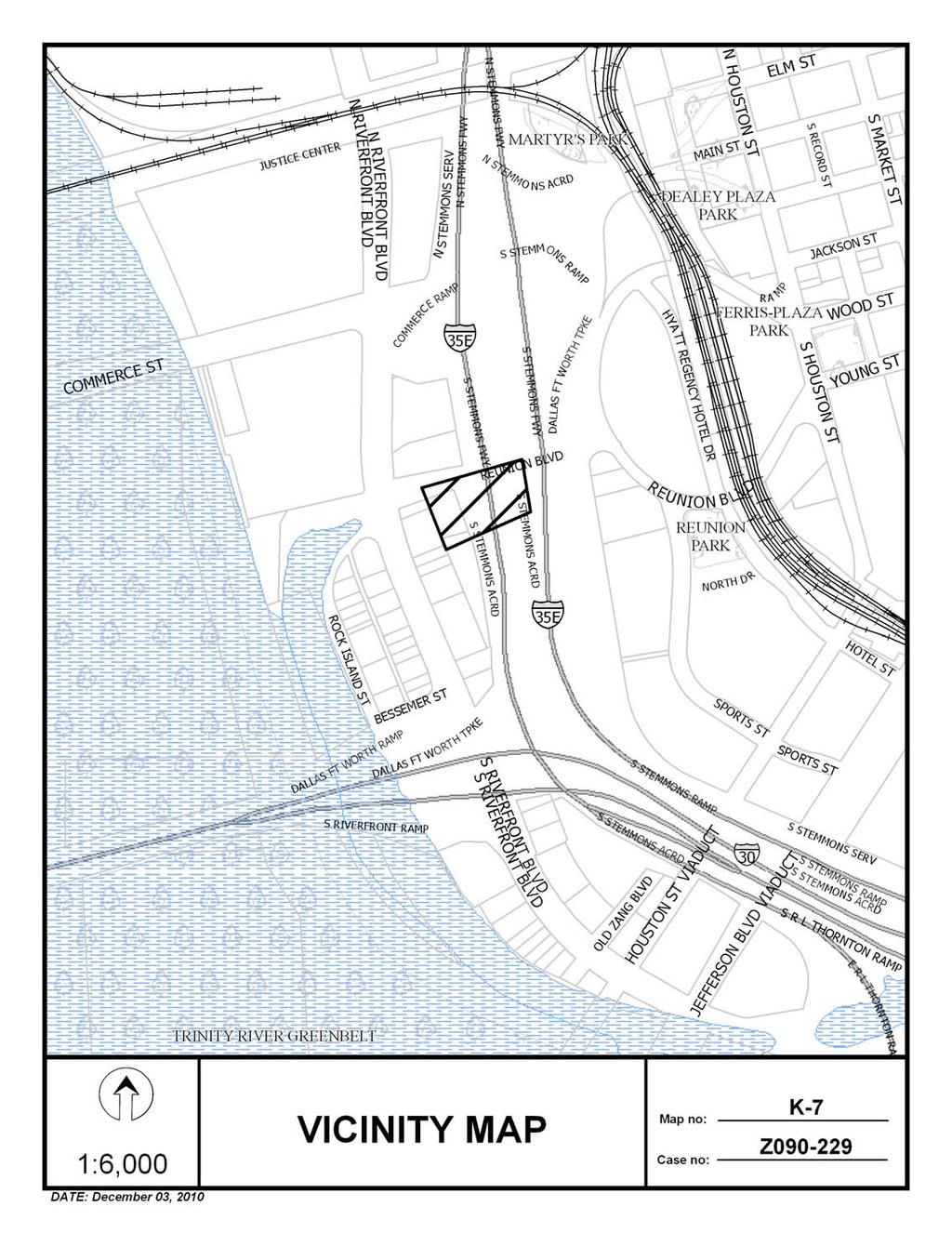
134 Z (RB) 4-7
135 Z (RB) Commercial, Retail, Surface parking Commercial, Retail, Office, Bail Bonds Office, Retail, Animal clinic w/outside runs 4-8
136 Z (RB) 1 4-9
137 Z (RB) 4-10
138 Z (RB) Page 1 of 1 12/3/2010 Notification List of Property Owners Z Property Owners Notified Label # Address Owner REUNION WISK STACEY REUNION WISK STACEY RIVERFRONT RIEKE LUCY CHRISTINE TR ETAL RIVERFRONT RIEKE LUCY CHRISTINE TR ETAL RIVERFRONT RIEKE LUCY CHRISTINE TR & ETAL RIVERFRONT RIEKE LUCY CHRISTINE TR ETAL RIVERFRONT RIEKE LUCY CHRISTINE TR ETAL RIVERFRONT TAYLOR DAVID D JR ET AL RIVERFRONT JIFFY PROPERTIES LP RIVERFRONT FRANCIS FAMILY HOLDINGS LTD Friday, December 03,
139 CITY PLAN COMMISSION THURSDAY, FEBRUARY 3, 2011 Planner: Richard E. Brown FILE NUMBER: Z (RB) DATE FILED: July 31, 2010 LOCATION: Reunion Boulevard and Riverfront Boulevard, Southeast Corner COUNCIL DISTRICT: 2 MAPSCO: 45 N SIZE OF REQUEST: Approx. 7,409 Sq. Ft. CENSUS TRACT: 100 APPLICANT: REPRESENTATIVE: OWNER: REQUEST: SUMMARY: Jullis Acosta Mata Santos Martinez Jiffy Properties, LP-Lauren L. Oznick, General Partner An application for a Specific Use Permit for a Bail bonds office on property within Planned Development District No. 784, the Trinity River Corridor Special Purpose District. The applicant is proposing to operate a bail bonds office in a portion of the building. STAFF RECOMMENDATION: Approval for a two-year period with eligibility for additional two-year periods, subject to a site plan and conditions. 5-1
140 Z (RB) BACKGROUND INFORMATION: On September 24, 2008, the City Council approved the creation of PDD No The request site is located within the Mixmaster Riverfront Subarea. The applicant is requesting an SUP in order to operate a bail bonds office (420 sf) in a portion of the existing building. Zoning History: File No. Request, Disposition, and Date 1. Z An SUP for a Bail bonds office. Pending a January 20, 2011 City Plan Commission public hearing. Thoroughfare/Street Reunion Boulevard Riverfront Boulevard Designation; Existing & Proposed ROW Local: Variable ROW Principal Arterial; 130 & 130 ROW Comprehensive Plan: The site is located within an area identified as a Commercial Corridor. These areas primarily function as service and job destinations and are similar to Business Centers or Corridors, but are smaller and incorporate less density. These corridors, commonly at the intersection of major streets, are easily accessed via automobiles. Buckner Boulevard is an example of a Commercial Corridor. Buildings in these areas tend to be on separate parcels and stand one to five stories with offices, restaurants and a range of retail and commercial uses. In addition to jobs and services, Commercial Centers or Corridors also may include multifamily housing in low- to midrise apartment buildings or condominiums. Landscaping and urban design will enhance the visitor s experience and is used to separate sidewalks from major roads and define pedestrian routes in large parking lots. For large shopping centers, this may involve adding public plazas or other town center features. Public transit enhancements as well as quality access and visibility are important components of successful autooriented development. 5-2
141 Z (RB) LAND USE ELEMENT GOAL 1.2 Promote desired development. Policy Use Vision Building Blocks as a general guide for desired development patterns. STAFF ANALYSIS: Land Use Compatibility: The request site is developed with a commercial structure and surface parking area. The applicant proposes to operate a bail bonds office within the extreme northeast corner of the building, occupying 420 square feet of floor area. The creation of PDD No. 784 requires an SUP for the use. Surrounding land use consists of a mix of nonresidential uses in all directions, with the request for an SUP for a bail bonds office (see Zoning History) abutting its eastern property line. It should be noted there are numerous bail bonds offices on properties concentrated along Riverfront Boulevard. The general provisions for a Specific Use Permit in Section 51A of the Dallas Development Code specifically state: (1) The SUP provides a means for developing certain uses in a manner in which the specific use will be consistent with the character of the neighborhood; (2) Each SUP application must be evaluated as to its probable effect on the adjacent property and the community welfare and may be approved or denied as the findings indicate appropriate; (3) The city council shall not grant an SUP for a use except upon a finding that the use will: (A) complement or be compatible with the surrounding uses and community facilities; (B) contribute to, enhance, or promote the welfare of the area of request and adjacent properties; (C) not be detrimental to the public health, safety, or general welfare; and (D) conform in all other respects to all applicable zoning regulations and standards. The regulations in this chapter have been established in accordance with a comprehensive plan for the purpose of promoting the health, safety, morals, and general welfare of the city. Staff has determined the applicant s request, subject to the attached site plan and conditions, complies with the intent of the requirements for a specific use permit. Off-Street Parking: Based on existing floor area of 420 square feet, the applicant s request requires one off-street parking space. Traffic: The Engineering Section of the Department Sustainable Development and Construction has reviewed the request and determined that it will not negatively impact the surrounding street system. 5-3
142 Z (RB) Landscaping: The applicant is not proposing additional floor area or nonpermeable surface area that would require additional landscaping. In working with staff to begin efforts bringing forward the vision for landscaping the main corridors throughout the PDD, the applicant will be providing two landscape areas (planters along the eastern property line and the northern and western facades). The required landscaping will be required within three months of City Council approval of the request. Miscellaneous-Certificate of Occupancy History: As noted above, the occupancy activity related to this site before and after creation of PDD No. 784: 10/14/04-certificate of occupancy for a general merchandise or food store 2/26/10-certificate of occupancy for an office (note on c/o stating no bail bonds) 5/19/10-certificate of occupancy for an office (no bail bonds) 5-4
143 Z (RB) STAFF S RECOMMENDED CONDITIONS FOR A SPECIFIC USE PERMIT FOR A BAIL BONDS OFFICE 1. USE: The only use authorized by this specific use permit is a bail bonds office. 2. SITE PLAN: Use and development of the Property must comply with the attached site plan. 3. TIME LIMIT: This specific use permit expires on (two years from the passage of the ordinance), but is eligible for automatic renewal for additional two-year periods pursuant to Section 51A of Chapter 51A of the Dallas City Code, as amended. For automatic renewal to occur, the Property owner must file a complete application for automatic renewal with the director before the expiration of the current period. Failure to timely file a complete application will render this specific use permit ineligible for automatic renewal. (Note: The Code currently provides that applications for automatic renewal must be filed after the 180th but before the 120th day before the expiration of the current specific use permit period. The Property owner is responsible for checking the Code for possible revisions to this provision. The deadline for applications for automatic renewal is strictly enforced.) 4. LANDSCAPING: Within three months after passage of this ordinance, landscaping must be provided as shown on the attached site plan. Landscaping must be maintained in a healthy, growing condition. 5. INGRESS-EGRESS: Ingress and egress must be provided in the location shown on the attached site plan. No other ingress or egress is permitted. 6. MAINTENANCE: The Property must be properly maintained in a state of good repair and neat appearance. 7. GENERAL REQUIREMENTS: Use of the Property must comply with all federal and state laws and regulations, and with all ordinances, rules, and regulations of the City of Dallas. 5-5
144 Z (RB) At this time, the applicant has not provided an acceptable site plan 5-6

145 Z (RB) 5 5-7
CITY OF DALLAS. CITY PLAN COMMISSION Thursday, November 19, 2009 AGENDA. BRIEFINGS: 5ES 11:30 a.m. PUBLIC HEARING Council Chambers 1:30 p.m.
 CITY OF DALLAS CITY PLAN COMMISSION Thursday, AGENDA BRIEFINGS: 5ES 11:30 a.m. PUBLIC HEARING Council Chambers 1:30 p.m. *The may be briefed on any item on the agenda if it becomes necessary. BRIEFINGS:
CITY OF DALLAS. CITY PLAN COMMISSION Thursday, November 2, 2006 AGENDA. BRIEFINGS: 5ES 11:00 a.m. PUBLIC HEARING Council Chambers 1:30 p.m.
 CITY OF DALLAS CITY PLAN COMMISSION Thursday, AGENDA BRIEFINGS: 5ES 11:00 a.m. PUBLIC HEARING Council Chambers 1:30 p.m. *The may be briefed or visit any item on the agenda if it becomes necessary. BRIEFINGS:
CITY OF DALLAS. CITY PLAN COMMISSION Thursday, February 9, 2006 AGENDA
 CITY OF DALLAS CITY PLAN COMMISSION Thursday, AGENDA BUS TOUR See attachment 9:30 a.m. BRIEFINGS: 5ES Following bus tour PUBLIC HEARING Council Chambers 1:30 p.m. *The may be briefed or visit any item
CITY OF DALLAS. CITY PLAN COMMISSION Thursday, August 5, 2010 AGENDA. BRIEFINGS: 6ES 11:00 a.m. PUBLIC HEARING 6ES 1:30 p.m.
 CITY OF DALLAS CITY PLAN COMMISSION Thursday, AGENDA BRIEFINGS: 6ES 11:00 a.m. PUBLIC HEARING 6ES 1:30 p.m. *The City Plan Commission may be briefed on any item on the agenda if it becomes necessary. BRIEFINGS:
CITY OF DALLAS. CITY PLAN COMMISSION Thursday, November 1, 2007 AGENDA. BRIEFINGS: 5ES 11:00 a.m. PUBLIC HEARING Council Chambers 1:30 p.m.
 CITY OF DALLAS CITY PLAN COMMISSION Thursday, AGENDA BRIEFINGS: 5ES 11:00 a.m. PUBLIC HEARING Council Chambers 1:30 p.m. *The City Plan Commission may be briefed or visit any item on the agenda if it becomes
CITY OF DALLAS. CITY PLAN COMMISSION Thursday, May 11, 2006 AGENDA
 CITY OF DALLAS CITY PLAN COMMISSION Thursday, AGENDA BUS TOUR: See attachment 9:00 a.m. BRIEFINGS: 5ES following bus tour PUBLIC HEARING Council Chambers 1:30 p.m. *The City Plan Commission may be briefed
CITY OF DALLAS. CITY PLAN COMMISSION Thursday, July 13, 2006 AGENDA
 CITY OF DALLAS CITY PLAN COMMISSION Thursday, AGENDA BUS TOUR: See attachment 9:00 a.m. BRIEFINGS: 5ES Following bus tour PUBLIC HEARING Council Chambers 1:30 p.m. *The City Plan Commission may be briefed
CITY OF DALLAS. CITY PLAN COMMISSION Thursday, March 5, 2009 AGENDA. BRIEFINGS: 5ES 11:00 a.m. PUBLIC HEARING Council Chambers 1:30 p.m.
 CITY OF DALLAS CITY PLAN COMMISSION Thursday, AGENDA BRIEFINGS: 5ES 11:00 a.m. PUBLIC HEARING Council Chambers 1:30 p.m. *The City Plan Commission may be briefed on the agenda if it becomes necessary.
CITY OF DALLAS. CITY PLAN COMMISSION Thursday, April 3, 2008 AGENDA. BRIEFINGS: 5ES 10:30 a.m. PUBLIC HEARING Council Chambers 1:30 p.m.
 CITY OF DALLAS CITY PLAN COMMISSION Thursday, AGENDA BRIEFINGS: 5ES 10:30 a.m. PUBLIC HEARING Council Chambers 1:30 p.m. *The City Plan Commission may be briefed or visit any item on the agenda if it becomes
CITY PLAN COMMISSION Thursday, June 7, 2012 AGENDA. BRIEFINGS: 5ES 11:00 a.m. PUBLIC HEARING Council Chambers 1:30 p.m.
 CITY PLAN COMMISSION Thursday, AGENDA BRIEFINGS: 5ES 11:00 a.m. PUBLIC HEARING Council Chambers 1:30 p.m. *The City Plan Commission may be briefed on any item on the agenda if it becomes necessary. BRIEFINGS:
CITY OF DALLAS. CITY PLAN COMMISSION Thursday, January 8, 2009 AGENDA. BRIEFINGS: 5ES 10:30 a.m. PUBLIC HEARING Council Chambers 1:30 p.m.
 CITY OF DALLAS CITY PLAN COMMISSION Thursday, AGENDA BRIEFINGS: 5ES 10:30 a.m. PUBLIC HEARING Council Chambers 1:30 p.m. *The may be briefed on the agenda if it becomes necessary. BRIEFINGS: Subdivision
CITY OF DALLAS. CITY PLAN COMMISSION Thursday, December 20, 2007 AGENDA. BRIEFINGS: 5ES 10:00 a.m. PUBLIC HEARING Council Chambers 1:30 p.m.
 CITY OF DALLAS CITY PLAN COMMISSION Thursday, AGENDA BRIEFINGS: 5ES 10:00 a.m. PUBLIC HEARING Council Chambers 1:30 p.m. *The City Plan Commission may be briefed or visit any item on the agenda if it becomes
CITY OF DALLAS. CITY PLAN COMMISSION Thursday, February 15, 2007 AGENDA. BRIEFINGS: 5ES 3:30 p.m. PUBLIC HEARING Council Chambers 6:00 p.m.
 CITY OF DALLAS CITY PLAN COMMISSION Thursday, AGENDA BRIEFINGS: 5ES 3:30 p.m. PUBLIC HEARING Council Chambers 6:00 p.m. *The may be briefed or visit any item on the agenda if it becomes necessary. BRIEFINGS:
CITY OF DALLAS CITY PLAN COMMISSION Thursday, June 18, 2015 AGENDA. BREFINGS: 5ES 11:00 a.m. PUBLIC HEARING: Council Chambers 1:30 p.m.
 CITY OF DALLAS CITY PLAN COMMISSION Thursday, AGENDA BREFINGS: 5ES 11:00 a.m. PUBLIC HEARING: Council Chambers 1:30 p.m. *The City Plan Commission may be briefed on any item on the agenda if it becomes
CITY OF DALLAS. CITY PLAN COMMISSION Thursday, January 27, BRIEFINGS: 5ES 10:00 a.m. PUBLIC HEARING CC Chambers 1:30 p.m.
 CITY OF DALLAS CITY PLAN COMMISSION Thursday, BRIEFINGS: 5ES 10:00 a.m. PUBLIC HEARING CC Chambers 1:30 p.m. *The City Plan Commission may be briefed on any item on the agenda if it becomes necessary.
CITY OF DALLAS. CITY PLAN COMMISSION Thursday, December 15, 2005 AGENDA. BRIEFINGS: 5ES 10:00 a.m. PUBLIC HEARING Council Chambers 1:30 p.m.
 CITY OF DALLAS CITY PLAN COMMISSION Thursday, AGENDA BRIEFINGS: 5ES 10:00 a.m. PUBLIC HEARING Council Chambers 1:30 p.m. *The City Plan Commission may be briefed or visit any item on the agenda if it becomes
CITY OF DALLAS. CITY PLAN COMMISSION Thursday, January 10, 2008 AGENDA. BRIEFINGS: 5ES Following bus tour PUBLIC HEARING Council Chambers 1:30 p.m.
 CITY OF DALLAS CITY PLAN COMMISSION Thursday, AGENDA BUS TOUR: 9:00 a.m. BRIEFINGS: 5ES Following bus tour PUBLIC HEARING Council Chambers 1:30 p.m. *The City Plan Commission may be briefed or visit any
CITY OF DALLAS. CITY PLAN COMMISSION Thursday, August 23, 2007 AGENDA. BRIEFINGS: 5ES 9:00 a.m. PUBLIC HEARING Council Chambers 1:30 p.m.
 CITY OF DALLAS CITY PLAN COMMISSION Thursday, AGENDA BRIEFINGS: 5ES 9:00 a.m. PUBLIC HEARING Council Chambers 1:30 p.m. *The City Plan Commission may be briefed or visit any item on the agenda if it becomes
CITY OF DALLAS. REVISED CITY PLAN COMMISSION Thursday, April 20, 2006 AGENDA. BRIEFINGS: 5ES 10:00 a.m. PUBLIC HEARING Council Chambers 1:30 p.m.
 CITY OF DALLAS REVISED CITY PLAN COMMISSION Thursday, AGENDA BRIEFINGS: 5ES 10:00 a.m. PUBLIC HEARING Council Chambers 1:30 p.m. *The may be briefed or visit any item on the agenda if it becomes necessary.
NOTICE FOR POSTING MEETING OF BOARD OF ADJUSTMENT, PANEL A TUESDAY, APRIL 20, 2010
 NOTICE FOR POSTING MEETING OF BOARD OF ADJUSTMENT, PANEL A TUESDAY, APRIL 20, 2010 Briefing: 11:00 A.M. 5/E/S Public Hearing: 1:00 P.M. COUNCIL CHAMBERS Purpose: To take action on the attached agenda,
NOTICE FOR POSTING MEETING OF BOARD OF ADJUSTMENT, PANEL A TUESDAY, FEBRUARY 15, 2011
 NOTICE FOR POSTING MEETING OF BOARD OF ADJUSTMENT, PANEL A TUESDAY, FEBRUARY 15, 2011 Briefing: 11:00 A.M. 5/E/S Public Hearing: 1:00 P.M. COUNCIL CHAMBERS Purpose: To take action on the attached agenda,
CITY OF DALLAS. CITY PLAN COMMISSION Thursday, January 6, BRIEFINGS: 5ES 11:00 a.m. PUBLIC HEARING CC Chambers 1:30 p.m.
 CITY OF DALLAS CITY PLAN COMMISSION Thursday, BRIEFINGS: 5ES 11:00 a.m. PUBLIC HEARING CC Chambers 1:30 p.m. *The may be briefed on any item on the agenda if it becomes necessary. Theresa O Donnell, Director
CITY OF DALLAS. CITY PLAN COMMISSION Thursday, August 11, 2005
 CITY OF DALLAS CITY PLAN COMMISSION Thursday, BUS TOUR 6015 Bryan Parkway 8:45 a.m. BRIEFINGS: 5ES following bus tour PUBLIC HEARING Council Chambers 1:30 p.m. *The may be briefed on any item on the agenda
CITY OF DALLAS. CITY PLAN COMMISSION Thursday, September 8, 2005 AGENDA. BRIEFINGS: 5ES 10:30 a.m. PUBLIC HEARING Council Chambers 1:30 p.m.
 CITY OF DALLAS CITY PLAN COMMISSION Thursday, AGENDA BRIEFINGS: 5ES 10:30 a.m. PUBLIC HEARING Council Chambers 1:30 p.m. *The City Plan Commission may be briefed on any item on the agenda if it becomes
CITY OF DALLAS CITY PLAN COMMISSION Thursday, February 18, 2016 AGENDA
 CITY OF DALLAS CITY PLAN COMMISSION Thursday, AGENDA BRIEFINGS: 5ES 10:30 a.m. PUBLIC HEARING: Council Chambers 1:30 p.m. *The may be briefed on any item on the agenda if it becomes necessary. BRIEFINGS:
NOTICE FOR POSTING MEETING OF BOARD OF ADJUSTMENT, PANEL C MONDAY, MAY 18, Briefing: 10:00 A.M. 5/E/S Public Hearing: 1:00 P.M.
 NOTICE FOR POSTING MEETING OF BOARD OF ADJUSTMENT, PANEL C MONDAY, MAY 18, 2009 Briefing: 10:00 A.M. 5/E/S Public Hearing: 1:00 P.M. COUNCIL CHAMBERS Purpose: To take action on the attached agenda, which
TOWN OF LEWISTON PLANNING BOARD APPLICATION
 TOWN OF LEWISTON PLANNING BOARD APPLICATION DESCRIPTION OF PROPOSED REQUEST: Name of Property Owner: Phone #: Name of Applicant:Phone #: Address or Location of Proposal:_SBL# Size of Parcel or Structure:Existing
INFORMATION & PROCEDURES FOR CHANGE OF ZONING REQUESTS AND CONDITIONAL USE PERMITS
 INFORMATION & PROCEDURES FOR CHANGE OF ZONING REQUESTS AND CONDITIONAL USE PERMITS The applicant is strongly encouraged to attend a pre-application meeting for the project prior to submittal of a zoning
Preliminary Plat & Layout Plan Submittal Guidelines
 Preliminary Plat & Layout Plan Submittal Guidelines PRELIMINARY PLAT & LAYOUT PLANS is typically the first step in the platting process. The purpose of the PRELIMINARY PLAT & LAYOUT PLANS is for the Applicant
Residential Major Subdivision Review Checklist
 Residential Major Subdivision Review Checklist Plan Submittal Requirements: 2 full sets of stamped plans Electric submittal - all plans contained in a single PDF 3 full sets if commercial kitchen or dining
ADDENDUM CITY COUNCIL MEETING AUGUST 22, 2001 CITY OF DALLAS 1500 MARILLA COUNCIL CHAMBERS, CITY HALL DALLAS, TEXAS :00 A.M.
 CITY OF DALLAS 1500 MARILLA COUNCIL CHAMBERS, CITY HALL DALLAS, TEXAS 75201 9:00 A.M. ADDITIONS: ITEMS FOR INDIVIDUAL CONSIDERATION 1. Authorize settlement of a claim filed by Wayne Love, Claim No. 95007750
Residential Minor Subdivision Review Checklist
 Residential Minor Subdivision Review Checklist Plan Submittal Requirements: 2 full sets of stamped plans Electric submittal - all plans contained in a single PDF 3 full sets if commercial kitchen or dining
NOTICE FOR POSTING MEETING OF BOARD OF ADJUSTMENT, PANEL B WEDNESDAY, MARCH 18, 2009
 NOTICE FOR POSTING MEETING OF BOARD OF ADJUSTMENT, PANEL B WEDNESDAY, MARCH 18, 2009 Briefing: 10:00 A.M. 5/E/S Public Hearing: 1:00 P.M. COUNCIL CHAMBERS Purpose: To take action on the attached agenda,
PLANNING & ZONING COMMISSION MEETING THURSDAY, NOVEMBER 10, 2016 AT 6:30 P.M. JUSTIN CITY HALL 415 NORTH COLLEGE STREET JUSTIN, TEXAS 76247
 PLANNING & ZONING COMMISSION MEETING THURSDAY, NOVEMBER 10, 2016 AT 6:30 P.M. JUSTIN CITY HALL 415 NORTH COLLEGE STREET JUSTIN, TEXAS 76247 I. Call To Order: Invocation and Pledge of Allegiance. II. Public
Planning Commission 16 February 4, 2014 EDMOND PLANNING COMMISSION MEETING. Tuesday, February 4, 2014
 Planning Commission 16 EDMOND PLANNING COMMISSION MEETING Tuesday, 5:30 P.M. The Edmond Planning Commission Meeting was called to order by Chairperson Barry K. Moore at 5:30 p.m., Tuesday,, in the City
CITY COUNCIL MEETING 4:00 P.M.
 CITY COUNCIL MEETING 4:00 P.M. APRIL 4, 2006 CITY HALL 116 WEST BRIDGE ST. GRANBURY, TEXAS *Note: The City Council reserves the right to adjourn into Executive Session at any time during the meeting to
CONCEPT PLAN SUBMISSION REQUIREMENTS:
 STAFF STRONGLY RECOMMENDS A PRE-DEVELOPMENT MEETING BEFORE THE SUBMITTAL OF ANY APPLICATION FOR ZONING, REZONING, CONDITIONAL USE PERMIT (CUP), OR FOR A TEXT AMENDMENT TO A PROVISION(S) OF THE ZONING ORDINANCE.
SUBDIVISION APPLICATION
 SUBDIVISION APPLICATION Preliminary Plat Minor Plat Final Plat Amended Plat Applicant Name: Owner (if different from applicant) Name: Company: Company: Address: Address: City, State, Zip City, State, Zip
Department of Planning & Development Services
 Department of Planning & Development Services S T A F F R E P O R T February 9, 2015 CASE NO: PROJECT: EXECUTIVE SUMMARY: ZA14-154 Plat Revision for Lots 25R-1A, 25R-1B and 25R-1C, Block 1, Woodland Heights
NOTICE FOR POSTING MEETING OF BOARD OF ADJUSTMENT, PANEL A TUESDAY, MAY 19, 2009
 NOTICE FOR POSTING MEETING OF BOARD OF ADJUSTMENT, PANEL A TUESDAY, MAY 19, 2009 Briefing: 10:00 A.M. 5/E/S Public Hearing: 1:00 P.M. COUNCIL CHAMBERS Purpose: To take action on the attached agenda, which
MINOR SUBDIVISION INFORMATION
 A. POINTS OF CONTACT: MINOR SUBDIVISION INFORMATION Surveyor: Address: Phone #: Fax # E-Mail Address: Representative (If different from applicant): Address: Phone #: Fax # E-Mail Address: B. GENERAL INFORMATION:
DAUPHIN CREEK ESTATES SUBDIVISION
 # 12 SUB-000076-2017 DAUPHIN CREEK ESTATES SUBDIVISION Engineering Comments: FINAL PLAT COMMENTS (should be addressed prior to submitting the FINAL PLAT for review and/or signature by the City Engineer):
PLANNING BOARD AGENDA
 PLANNING BOARD AGENDA Public Hearing and Administrative Meeting Wednesday,, 1:30 P.M. Omaha/Douglas Civic Center 1819 Farnam Street Legislative Chamber DISPOSITION AGENDA This document states the disposition
Preliminary Plat Application & Submittal Checklist
 Planning & Community Development Department 550 Landa Street New Braunfels, Texas 78130 (830) 221-4050 www.nbtexas.org Preliminary Plat Application & Submittal Checklist Applicant Name: *Signature. * By
MINUTES PLANNING AND ZONING COMMISSION REGULAR SESSION NOVEMBER 21, 2016
 MINUTES PLANNING AND ZONING COMMISSION REGULAR SESSION NOVEMBER 21, 2016 The Planning and Zoning Commission of the City of Granbury convened in regular session on Monday, November 21, 2016 at Granbury
WASTEWATER BACKFLOW RELEASE PROCEDURES
 WASTEWATER BACKFLOW RELEASE PROCEDURES PROCEDURE FOR OBTAINING A WASTEWATER RELEASE FOR PRIVATE DEVELOPMENT PROJECTS: PLEASE NOTE THAT THE WASTEWATER BACKFLOW RELEASE DOCUMENT MUST FOLLOW THE CITY S PROCEDURES.
PLANNING COMMISSION REPORT Regular Agenda Public Hearing Item
 PC Staff Report 11/12/12 Item No. 2B- 1 PLANNING COMMISSION REPORT Regular Agenda Public Hearing Item ITEM NO. 2B: A TO GPI; 110 ACRES; E OF K-10 & N OF W 6 TH ST (MKM) : Consider a request to rezone approximately
ARTICLE 900 PLAT AND PLAN REQUIREMENTS
 ARTICLE 900 PLAT AND PLAN REQUIREMENTS SEC. 900.1 ITEMS TO BE SHOWN ON PLAT OR PLAN General (1) Property lines of all property owners adjacent to the exterior boundaries of the project shall be located
Conditional Use Permit / Standard Subdivision Application
 Conditional Use Permit / Standard Subdivision Application Name of Proposed Subdivision: Total Area (Acres) Is Proposed Subdivision to be built in phases? Number of Lots If yes, how many phases? Applicant/Owner
DALLAS WATER UTILITIES WATER/WASTEWATER COVENANT
 DALLAS WATER UTILITIES WATER/WASTEWATER COVENANT Procedure for obtaining a water and wastewater covenant, water covenant, or wastewater covenant; Required for initial submittal: 1. One letter from the
MINOR PLAT. The following documents are provided as required by the City of Conroe for use in the above titled platting submittals:
 Public Works - Engineering Division CITY OF CONROE MINOR PLAT The following documents are provided as required by the City of Conroe for use in the above titled platting submittals: Submittal Questionnaire
Condominium Unit Requirements.
 ARTICLE 19 CONDOMINIUM REGULATIONS Section 19.01 Purpose. The purpose of this Article is to regulate projects that divide real property under a contractual arrangement known as a condominium. New and conversion
REPORT TO THE SHELBY COUNTY PLANNING COMMISSION From the Department of Development Services Planning Services. February 4, 2019
 REPORT TO THE SHELBY COUNTY PLANNING COMMISSION From the Department of Development Services Planning Services February 4, 2019 Case No. Request for Rezoning Approval From E-1 to E-2 SD This is a request
Final Plats for Major Residential and Commercial Subdivisions Checklist
 Project Name: : This form is a checklist of Zoning Ordinance requirements for major residential and commercial subdivision plats to assist the applicant in their submittal. It is not intended to be a comprehensive
A GUIDE TO PROCEDURES FOR: SUBDIVISIONS & CONDOMINIUM CONVERSION
 A GUIDE TO PROCEDURES FOR: SUBDIVISIONS & CONDOMINIUM CONVERSION A GUIDE TO PROCEDURES FOR: SUBDIVISIONS (TENTATIVE MAPS) PURPOSE Definition: A subdivision is defined as the division of any improved or
AGENDA. EDMOND PLANNING COMMISSION 20 S. Littler, Edmond, Oklahoma Tuesday, February 18, :30 p.m. CITY COUNCIL WORKSHOP
 City of Edmond NOTICE OF PUBLIC MEETING The City of Edmond encourages participation from all its citizens. If participation at any Public meeting is not possible due to a disability, notification to the
MEMBERS PRESENT: Darrin Buskirk, Buan Smith, Chris Cobbler, Mitzi Delius, Jeri Hartley, J. Smith, Bruce Southworth, Pattie Wilson
 ON TUESDAY, JANUARY 19, 2016 THE TECHNICAL REVIEW COMMITTEE HELD THEIR MEETING AT 10:00 A.M. IN THE 2 ND FLOOR COURTROOM OF THE WOODFORD COUNTY COURTHOUSE. MEMBERS PRESENT: Darrin Buskirk, Buan Smith,
CHAPTER 3 PRELIMINARY PLAT
 10-3-1 10-3-3 SECTION: CHAPTER 3 PRELIMINARY PLAT 10-3-1: Consultation 10-3-2: Filing 10-3-3: Requirements 10-3-4: Approval 10-3-5: Time Limitation 10-3-6: Grading Limitation 10-3-1: CONSULTATION: Each
SUBDIVISION APPLICATION CHECKLIST SKETCH PLAN PRELIMINARY PLAT FINAL PLAT
 RECEIVED STAMP SUBDIVISION APPLICATION CHECKLIST SKETCH PLAN PRELIMINARY PLAT FINAL PLAT A checklist of background information and submission requirements for processing of a sketch plan, preliminary plat
WESTMINSTER PARK PLACE SUBDIVISION
 WESTMINSTER PARK PLACE SUBDIVISION Engineering Comments: FINAL PLAT COMMENTS (should be addressed prior to submitting the FINAL PLAT for review and/or signature by the City Engineer): A. Provide all of
Section Preliminary Plat Checklist and Application Forms
 Section 201 - Preliminary Plat Checklist and Application Forms PRELIMINARY SUBDIVISION PLAT REVIEW PROCESS CHART PRELIMINARY SUBDIVISION PLAT APPLICATION PRELIMINARY PLAT REVIEW CHECKLIST CITY OF NAMPA
Subchapter 16 Subdivisions.
 Subchapter 16 Subdivisions. Sections: 35.16.1 Authority. 35.16.2 Purpose. 35.16.3 Jurisdiction. 35.16.4 Application. 35.16.5 Compliance and Enforcement. 35.16.6 Approval of Plat Required. 35.16.7 Lots,
City of Prior Lake APPLICATION FOR PRELIMINARY PLAT
 City of Prior Lake APPLICATION FOR PRELIMINARY PLAT Requested Action Brief description of proposed project (Please describe the proposed amendment, project, or variance request. Attach additional sheets
City of Shenandoah Development Package
 Upon completion return application to Development@shenandoahtx.us City of Shenandoah Development Package Documentation includes the following: Fee Schedule Platting Development Check List & Outline Development
CITY OF SARALAND FINAL SUBDIVISION PLAT REVIEW
 CITY OF SARALAND FINAL SUBDIVISION PLAT REVIEW Application Number: Date Plat Submitted: Name of Subdivision: Name of Owner: Owner Address: (Street or P.O. Box) Telephone #: (City) (State) (Zip) E-mail:
STAFF REPORT FOR MAJOR SUBDIVISION
 STAFF REPORT FOR MAJOR SUBDIVISION FINAL PLAT CASE NO. FA-13-001 HEARING DATE: November 6, 2013 CASE NAME: Solterra Subdivision Filing No. 14 PROCEDURE: Planning Commission ADDRESS OF MAJOR SUBDIVISION
CITY OF DECATUR, TEXAS
 CITY OF DECATUR, TEXAS AGENDA CITY COUNCIL MEETING Monday, January 14, 2018 REGULAR MEETING 6:00 p.m. CALL TO ORDER MOMENT OF SILENCE PLEDGE OF ALLEGIANCE Planning and Zoning Report: 1. CONSIDER TAKING
DEED RESTRICTION INFORMATION PACKET
 DEED RESTRICTION INFORMATION PACKET City of Dallas Department of Development Services 1500 Marilla St. #5BN Dallas, TX 75201 October 2002 Submit a completed application Staff review The Zoning Change Request
APPLICATION FOR SUBDIVISION APPROVAL OF A SKETCH PLAN with checklist
 Prior to filing any application for SUBDIVISION approval, the applicant shall request in writing that the zoning administrator schedule a pre-submission conference. APPLICATION TO THE PLANNING BOARD TOWN
SECTION 10 STANDARD PLATS
 SECTION 10 - STANDARD PLATS Subdivision 1: Purpose Standard Plats allow the subdivision of land into lots smaller than the minimum metes and bounds size in the zoning district, and control road development
AGENDA BURLESON PLANNING AND ZONING COMMISSION MEETING September 13, 2011 BURLESON CITY HALL 141 W. RENFRO BURLESON, TX 76028
 AGENDA BURLESON PLANNING AND ZONING COMMISSION MEETING BURLESON CITY HALL 141 W. RENFRO BURLESON, TX 76028 REGULAR SESSION 7:00 p.m. Call to Order Invocation All items listed below under 1. Consent Agenda
Initial Subdivision Applications Shall Include the Following:
 Initial Subdivision Applications Shall Include the Following: 1) Subdivision Application Form: completely filled out (12 copies) 2) Plat: The Plat must adhere to the requirements set forth in the Town
ELMORE COUNTY LAND USE & BUILDING DEPARTMENT 520 E 2 nd South Mountain Home, ID (208) Preliminary Plat Application
 Preliminary Plat Application") ELMORE COUNTY LAND USE & BUILDING DEPARTMENT 520 E 2 nd South Mountain Home, ID 83647 (208) 587-2142 www.elmorecounty.org Preliminary Plat Application We are unable to accept facsimile copies. (Subdivisions
ELMORE COUNTY LAND USE & BUILDING DEPARTMENT 520 E 2 nd South Mountain Home, ID 83647 (208) 587-2142 www.elmorecounty.org Preliminary Plat Application We are unable to accept facsimile copies. (Subdivisions
ZONING BOARD OF ADJUSTMENT, PANEL C MONDAY, OCTOBER 15, 2012 AGENDA
 ZONING BOARD OF ADJUSTMENT, PANEL C MONDAY, OCTOBER 15, 2012 AGENDA BRIEFING 5ES 11:30 A.M. LUNCH PUBLIC HEARING COUNCIL CHAMBERS, 1500 MARILLA STREET 1:00 P.M. David Cossum, Assistant Director Steve Long,
Application for Preliminary Plat Checklist
 Application for Preliminary Plat Checklist Note: No portion of an existing parcel may be sold or transferred to another party without first legally subdividing the property according to the City of Richmond
UPPER MOUNT BETHEL TOWNSHIP NORTHAMPTON COUNTY, PENNSYLVANIA
 UPPER MOUNT BETHEL TOWNSHIP NORTHAMPTON COUNTY, PENNSYLVANIA JOINDER DEED / LOT CONSOLIDATION TOWNSHIP REVIEW PROCESS When accepting proposed Joinder Deeds / Lot Consolidations, review the Joinder Deed
ARTICLE 900 PLAT AND PLAN REQUIREMENTS
 Final SEC. 900.01 ARTICLE 900 PLAT AND PLAN REQUIREMENTS General provisions. (a) Scale. The scale of all plats and plans shall be a minimum of 1 to 100 ft. (b) Size. The minimum page size for all plats
AGENDA CITY COUNCIL MEETING NOVEMBER 28, 2007 CITY OF DALLAS 1500 MARILLA COUNCIL CHAMBERS, CITY HALL DALLAS, TEXAS :00 A. M.
 AGENDA CITY COUNCIL MEETING NOVEMBER 28, 2007 CITY OF DALLAS 1500 MARILLA COUNCIL CHAMBERS, CITY HALL DALLAS, TEXAS 75201 9:00 A. M. Invocation and Pledge of Allegiance (Council Chambers) [07-3480] Agenda
PRELIMINARY PLAT Checklist
 PRELIMINARY PLAT Checklist 3715 Bridgeport Way W University Place, WA 98466 PH: (253) 566-5656 FAX: (253) 460-2541 This is a checklist of materials required for a Preliminary Plat. This checklist is provided
Betty Jefferson, Vice Chairman Rick Keeler Bonney Ramsey Jim Phillips Rodney Bell
 A regular meeting of the Planning & Zoning Commission of the City of Waxahachie was held on Tuesday, at 7:00 p.m. in the Council Chamber at 401 S. Rogers, Waxahachie, Texas. Members Present: Members Absent:
FINAL PLAT APPLICATION
 FINAL PLAT APPLICATION (Page 1 of 3) LEGAL OWNER(s): NAME: STREET ADDRESS OWNER(s): CITY, STATE, ZIP CODE: PHONE NUMBER: BILLING ADDRESS: NAME OF ENGINEER/SURVEYOR: Engineer/Surveyor Address, Phone: PROPERTY
Planning and Zoning Commission Agenda Regular Meeting May 3, th Street, City Council Chambers
 Planning and Zoning Commission Agenda Regular Meeting May 3, 2018 1625 13 th Street, City Council Chambers 5:30 p.m. Planning and Zoning Commission convenes in open session, in Committee Room 103 in City
PLANNED UNIT DEVELOPMENT & SUBDIVISION STAFF REPORT August 18, 2016
 PLANNED UNIT DEVELOPMENT & SUBDIVISION STAFF REPORT August 18, 2016 DEVELOPMENT NAME SUBDIVISION NAME Mullinax Ford Subdivision Mullinax Ford Subdivision LOCATION CITY COUNCIL DISTRICT District 6 Southeast
ZONING BOARD OF ADJUSTMENT, PANEL A TUESDAY, APRIL 17, 2018 AGENDA BRIEFING ROOM 5ES 11:00 A.M MARILLA STREET DALLAS CITY HALL
 ZONING BOARD OF ADJUSTMENT, PANEL A TUESDAY, APRIL 17, 2018 AGENDA BRIEFING ROOM 5ES 11:00 A.M. 1500 MARILLA STREET DALLAS CITY HALL PUBLIC HEARING COUNCIL CHAMBERS 1:00 P.M. 1500 MARILLA STREET DALLAS
Community Development Department Council Chambers, 7:30 PM, July 20, 2017
 STAFF REPORT 2017-25P: Subdivision Community Development Department Council Chambers, 7:30 PM, July 20, 2017 To: From: Re: Paul Luke, Chairman, Skokie Plan Commission Mike Voitik, Planning Technician 2017-25P:
THE CITY OF ELM SPRINGS
 THE CITY OF ELM SPRINGS APPLICATION & CHECKLIST FOR A REZONING FOR STAFF USE ONLY FEE: $ Date Application Submitted: PC Meeting Date: Date Accepted as Complete: Zone: Case / Appeal Number: APPLICATION:
HOME OCCUPATION SPECIAL USE PERMITS th Street North Stillwater MN
 216 4 th Street North Stillwater MN 55082 651-430-8800 HOME OCCUPATION A Home Occupation is a business or enterprise conducted in a dwelling or accessory dwelling and incidental to the principle residential
New Electronic Planning Commission Submittal Process
 New Electronic Planning Commission Submittal Process STANDARD OPERATING PROCEDURE Purpose: To outline the electronic submittal process for applications to the Planning Commission. Background: Procedure:
THE CITY OF MOBILE, ALABAMA
 THE CITY OF MOBILE, ALABAMA LETTER OF DECISION March 9, 2018 Byrd Surveying, Inc. 2609 Halls Mill Road Mobile, AL 36606 Re: 4439 Rangeline Road (Northwest corner of Rangeline Road and Halls Mill Road).
these areas are compatible with such conditions. [Section (6) (c) C. R. S.]
![these areas are compatible with such conditions. [Section (6) (c) C. R. S.]](/thumbs/83/88180230.jpg "these areas are compatible with such conditions. [Section (6) (c) C. R. S.]") SECTION 14-200 PRELIMINARY PLAT 14-201 INTENT A Preliminary Plat is one of the first documents utilized when owners of a property wish to subdivide their property in accordance with State Statutes and
SECTION 14-200 PRELIMINARY PLAT 14-201 INTENT A Preliminary Plat is one of the first documents utilized when owners of a property wish to subdivide their property in accordance with State Statutes and
CITY OF DECATUR, TEXAS
 CITY OF DECATUR, TEXAS AGENDA CITY COUNCIL MEETING Monday, October 8, 2018 REGULAR MEETING 6:00 p.m. CALL TO ORDER MOMENT OF SILENCE PLEDGE OF ALLEGIANCE 1. MAYOR WOODRUFF TO PRESENT A PROCLAMATION TO
CHAPTER 22 SUBDIVISION AND LAND DEVELOPMENT
 CHAPTER 22 SUBDIVISION AND LAND DEVELOPMENT 22-101. Title 22-102. Legislative Intent Part 1 General Provisions 22-201. Development Permits Part 2 Administration 22-301. Fee Schedule Part 3 Fee Schedule
NOTICE FOR POSTING MEETING OF BOARD OF ADJUSTMENT, PANEL A TUESDAY, MAY 20, 2008
 NOTICE FOR POSTING MEETING OF BOARD OF ADJUSTMENT, PANEL A TUESDAY, MAY 20, 2008 Briefing: 10:30 A.M. 5/E/S Public Hearing: 1:00 P.M. COUNCIL CHAMBERS Purpose: To take action on the attached agenda, which
REVISED MEETING OF THE
 REVISED MEETING OF THE TEMPLE CITY COUNCIL MUNICIPAL BUILDING 2 NORTH MAIN STREET 3 rd FLOOR CONFERENCE ROOM THURSDAY, JANUARY 18, 2018 3:15 P.M. AGENDA 1. Discuss, as may be needed, Regular Meeting agenda
SUBJECT PARCEL(S) Property Owner(s) TMS Number Approximate Acreage Carolina Park Development, LLC
 Property Owner(s) TMS Number Approximate Acreage Carolina Park Development, LLC") Staff Report Special Planning Commission Meeting November 19, 2014 For reference, the Zoning Code and Land Development Regulations are available online. AGENDA ITEM 5c. SKETCH PLAN APPROVAL REQUEST: Request
Staff Report Special Planning Commission Meeting November 19, 2014 For reference, the Zoning Code and Land Development Regulations are available online. AGENDA ITEM 5c. SKETCH PLAN APPROVAL REQUEST: Request
APPLICATION SUBMITTAL REQUIREMENTS FOR Tentative Parcel or Subdivision Maps
 CITY OF EL CERRITO Community Development Department Planning and Building Division 10890 San Pablo Avenue, El Cerrito, CA 94530 (510) 215-4330 FA (510) 233-5401 planning@ci.el-cerrito.ca.us APPLICATION
Applicant: Address: Fee Owner: Address: Property Location (Address and Complete (long) Legal Description: Detailed Reason for Request:
 Legal Description: Detailed Reason for Request:") Date Received: Received By: Permit #: LAND USE APPLICATION Comprehensive Plan Zoning District Amend Zoning Text Amend Variance*(see below) Zoning Appeal Conditional Use Permit (C.U.P.) Flood Plain C.U.P.
Date Received: Received By: Permit #: LAND USE APPLICATION Comprehensive Plan Zoning District Amend Zoning Text Amend Variance*(see below) Zoning Appeal Conditional Use Permit (C.U.P.) Flood Plain C.U.P.
MAJOR RESIDENTIAL AND NONRESIDENTIAL SUBDIVISIONS
 Lawrence-Douglas County MAJOR RESIDENTIAL AND NONRESIDENTIAL SUBDIVISIONS Preliminary Plats The applicant shall schedule a Pre-Application meeting with Planning Staff at least seven (7) working days prior
SECTION 4: PRELIMINARY PLAT
 SECTION 4: PRELIMINARY PLAT After the completion of the sketch plan process, if submitted, the owner or developer shall file with the City an application for preliminary plat. The preliminary plat stage
Rapid City Planning Commission
 Rapid City Planning Commission Initial Planned Development Overlay Project Report March 9, 2017 Item #15 Applicant Request(s) Case # 17PD007 Initial Planned Development Overlay to allow a residential development