Why Are We Here? What is a Military Installation Overlay Zone? Boundaries/Area Impacted Requirements for Safety, Noise, and Height
|
|
|
- Allen Greer
- 5 years ago
- Views:
Transcription
1
2 Why Are We Here? What is a Military Installation Overlay Zone? Boundaries/Area Impacted Requirements for Safety, Noise, and Height What is the Military Installation Overlay Zoning Map Amendment? Application of the M-I-O Zone to properties Comprehensive Zoning Changes Limitation on the Use of Zones District Development Overlay Zone Amendments Applicability and Exemptions How Will My Property Be Impacted? Schedule
3 To Explain what a Military Installation Overlay Zone is To Review the process and schedule for applying the MIOZ To describe how individual properties will be impacted Answer other questions you might have
 Study as may be amended from time to")
4 An overlay zone that establishes permitted and prohibited use, development regulations, site plan provisions, and permitting requirements for the M- I-O Zone It establishes specific boundaries Incorporates boundaries established in the DOD s Air Installation Compatible Use Zone (AICUZ) Study as may be amended from time to time
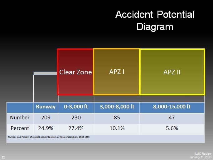
5 The boundaries of the MIOZ define 3 impact areas: Safety Zones, Noise (Levels) Contours, and Height Surfaces
6 Clear Zone Clubs, Day Care, Theaters, Landfills, Schools, Museums No Eating and Drinking Establishments Churches or similar places of worship All office uses above.08 FAR Retails sales Accident Potential Zone 1&2 Clubs, Day Care, Theaters, Landfills, Schools Limited Permitted Uses Churches (80 seats/6000 sq.ft) Eating and Drinking Establishments in MIO/C-S-C (6000 sq.ft) not in C-S-C (3,500 sq.ft) Offices (in I-1,I-2,I-3) 0.15 FAR Not in (I-1,I-2,I-3).08 FAR
7


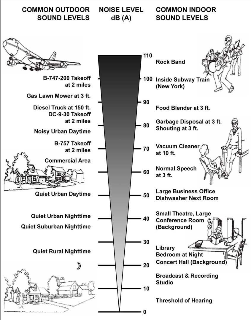
8 All Residential Construction must be attenuated to 45dBA in all contours High Noise Areas (>74 dba) Non residential uses must certify attenuation per Subtitle 4 Schools, Day Care centers, Playgrounds, Swimming pools, Outdoor Play Areas prohibited All other active outdoor recreational uses prohibited
9
 Certification that structures do not exceed the height established by")
 Area B = 50 :1 slope from runway Area D = 150 above runway")
10 Most structures will be regulated by the maximum height permitted in underlying zone. (The Stricter Height Limit applies) Certification that structures do not exceed the height established by the Impact Map is required at the time of building permit. Area A = Runway surface (no structures permitted) Area B = 50 :1 slope from runway Area D = 150 above runway Area E = 20 :1 slope from runway Area G = 7 :1 slope from Area B /50


11 555 ft. 289 ft. 270 ft. 180 ft. 70 ft.


12


13 Airport operations 141,000 Annual flights 314 Daily departures and landings 54 Types of aircraft Base personnel 7,191 Military 9,034 Civilian 16,225 Total
14 The MIOZMA is a process that will apply regulations to properties within the impacted area Requirements: Technical Staff Report for Public Inspection Joint Planning Board/County Council Public Hearing Planning Board Work Session and Endorsement District Council Work Session, Amendment or Final Action (The District Council has 180 from the time of transmittal from the PB to take final action on the MIOZMA or it is deemed disapproved.
15 Superimpose the M-I-O Zone affected properties Reclassify 18 parcels, located in APZ from C-O to C-S-C 3408, 3410 Forestville Place 3307 Forestville Place, 3309 Forestville Road 3312 Springdale Avenue 3100 Ritchie Road (8 units) 7500,7520, 7618 Marlboro Pike
16 1. Amendments to the Marlboro Pike District Development Overlay Zone: Amendment 1: Replace footnote reference regarding AICUZ with M-I-O Zone Amendment 1d2-1d4: Update the Table of Uses in the MUI, CSC and Light Industrial Zones to reflect prohibitions in the M-I-O Zone. Insert footnotes specifying limitations on eating and drinking establishments and churches 2. Southern Green Line District Development Overlay Zone Amendment 2: Revise District Development Standards to accommodate height restrictions per Sec (b) and Sec (e) for the Branch Avenue Metro Station Area
17 Amendments to the Marlboro Pike District Development Overlay Zone: Amendment 1a: Height Revise Development District Standards to accommodate height restrictions for towers, monopoles and other non-building structures to the (p. 142) Amendment 1b: Office Intensity Reduce the maximum floor area ratio for commercial (0.22) and industrial (0.6) uses to commercial office (.08) and (.15) for accessory offices (p. 143) Amendment 1c: Regulating Matrix for Residential and Commercial Mixed-Use Infill (p. 145) Reduce the maximum number of live/work units from 8 to 2 units within APZ 1&2
18 Sec permits District Council to reclassify the underlying zone of a property in the Safety Zones or High Intensity Noise Area to any other zone, subject to the following: No land in the Safety Zones of the M-I-O Zone shall be rezoned to a more intense residential zone No land in the Safety Zones of the M-I-O Zone shall be rezoned to a Mixed-Use Zone No land in the Safety Zones of the M-I-O Zone shall be rezoned to a Comprehensive Design Zone No land in the Safety Zones of the M-I-O Zone shall be placed in an Urban Center District


19
20 Permits for changes in ownership, name, or occupancy; with no changes in use; Permits for any grading or infrastructure improvements; Permits for any public utility, or private utility for public use; Permits issued pursuant to one of the following development approvals, provided that the application was approved prior to the date of classification of the property into the MIO Zone and the validity period for such approval has not expired: A final plat of subdivision approved for single-family detached residential development; A preliminary plan of subdivision for development not otherwise requiring a DSP; A Special Exception for development not otherwise requiring a DSP; A Detailed Site Plan; or a Specific Design Plan
21 Permits for fences or walls Alterations requiring a permit of a minor nature pursuant to Sec ; Areas of Prince George s County defined by the 2009 Joint Base Andrews Naval Air Facility Washington Joint Land Use Study as Imaginary Surfaces C (part of the Approach-Departure Clearance Surface) and F (Outer Horizontal Surface ) are not subject to the provisions of the M-I-O Zone.
22 What is the address? What is the primary use on the property? What part of the zone am I subject to? Height Noise Safety
23 Council Initiation/Authorization January 2016 Release for Public Inspection February 2016 Joint Public Hearing April 2016 Planning Board Endorsement June 2016 District Council Approval July 2016
Airport Influence District
 Airport Influence District Sections 800-822, Article 8, Chapter 146, Aurora Municipal Code (Includes up to Ordinance 2006-06, Effective April 8, 2006) City of Aurora Planning Department 15151 E. Alameda
LONG RANGE AGENDA July 19, 2018 July 26, 2018
 LONG RANGE AGENDA July 19, 2018 July 26, 2018 4-16001 PARKSIDE, SECTIONS 5 & 6...14 4-16037 FAIRVIEW CENTER...5 4-17026 ALDI DISTRICT HEIGHTS... 8 4-17039 CRAIN COMMONS... 15 4-18002 7618 MARLBORO PIKE...
Within PUD-LU districts, the following provisions shall apply:
 Sec. 8-3047. Development standards in PUD-LU zoning districts. Within PUD-LU districts, the following provisions shall apply: (a) (b) (c) Definition: planned unit development-limited use (PUD-LU). The
City Council Briefing Clear Creek Holdings, LLC. April 16, 2019 Robert J. Tajan, Director Planning and Community Development
 City Council Briefing April 16, 2019 Robert J. Tajan, Director Planning and Community Development 1 AICUZ Background Air Installation Compatible Use Zones Established in response to the Noise Control Act
Joint Land Use Study Implementation Technical Committee Meeting May 7, 2014
 Joint Land Use Study Implementation Technical Committee Meeting May 7, 2014 Naval Air Station Joint Reserve Base, New Orleans Belle Chasse, Louisiana Agenda Review and approve 4/14/14 minutes Review Policy
Article 10. Overlay Zones
 Article 10. Overlay Zones Sections: Sec. 1001 - Purpose and Objectives Sec. 1002 - DDOZ - Dairy Development Overlay Zone Sec. 1003 - NSOZ - Nutrient Spreading Overlay Zone Sec. 1004 - AOZ - Agriculture
Proposed Overland Park Kansas Ordinance RE-1 Residential Estates Community
 18.171 RE-1 Residential Estate Community 18.171.010 Statement of intent. The zoning of property as RE-1, (Residential Estates Community, 1 dwelling unit per Gross acre density), is intended to provide
AN AMENDMENT to the Montgomery County Zoning Ordinance to: - establish the Montgomery Village Overlay Zone. Development Standards for Euclidean Zones
 Concerning: New Overlay Zone Montgomery Village Draft No. & Date: 1-7/23/15 Introduced: Public Hearing: Adopted: Effective: Ordinance No.: COUNTY COUNCIL FOR MONTGOMERY COUNTY, MARYLAND SITTING AS THE
FOR DISCUSSION PURPOSES ONLY EDMONTON INTERNATIONAL AIRPORT VICINITY PROTECTION AREA REGULATION
 *UPDATES TO AN EXISTING REGULATION EDMONTON INTERNATIONAL AIRPORT VICINITY OTECTION AREA REGULATION Table of Contents 1 Definitions 2 Protection Area established 3 Subdivision approval and development
VOLUME II - APPENDIX B - BASIC ZONING ORDINANCE ARTICLE V. DISTRICT REGULATIONS
 Sec. 5.1000. Multiple-family Residential (R-5). (Ord. No. 4005, 1(Res. No. 8947, Exh. A, 55), 4-3-12) Sec. 5.1001. Purpose. This district is intended to provide for development of multiple-family residential
Sec Temporary Uses. Secs Reserved
 subject to any referenced use-specific standards and all other applicable regulations of this Ordinance: 1. Accessory dwelling unit (detached) 2. Kennel, private (for parcels less than 2 acres in size;
Article 3: Specific to Zones
 Article 3: Specific to Zones Content Page # Division 3.1: Establishment and Designation of Zones 3-1 3.1.10 Purpose 3-1 3.1.20 Establishment of Zones 3-1 3.1.30 Transect Zones 3-1 3.1.40 Overlay Zones
CHAPTER 4: DISTRICT REGULATIONS
 CHAPTER 4: DISTRICT REGULATIONS 4.1 COMPLIANCE WITH DISTRICT STANDARDS 4.1.1 No building or structure may be erected, converted, enlarged, reconstructed, altered for use, or used except in accordance with
CHARLOTTE CODE. PART 1: PURPOSE AND PART 2: MIXED USE DISTRICTS (MX-1, MX-2, and MX-3) CHAPTER 11:
 CHAPTER 11:") PART 1: PURPOSE AND PART 2: MIXED USE DISTRICTS (MX-1, MX-2, and MX-3) Section 11.101. Purpose. CHAPTER 11: CONDITIONAL ZONING DISTRICTS PART 1: PURPOSE The Conditional Zoning Districts allow for the establishment
PART 1: PURPOSE AND PART 2: MIXED USE DISTRICTS (MX-1, MX-2, and MX-3) Section 11.101. Purpose. CHAPTER 11: CONDITIONAL ZONING DISTRICTS PART 1: PURPOSE The Conditional Zoning Districts allow for the establishment
Subchapter 5 Zoning Districts and Limitations
 Subchapter 5 Zoning Districts and Limitations 35.5.1 Rural Districts Sections: 35.5.1.1 Purpose. 35.5.1.2 Permitted Uses. 35.5.1.3 General Regulations. 35.5.1.1 Purpose. The purpose of a Rural District
R E S O L U T I O N. 2. Development Data Summary:
 R E S O L U T I O N WHEREAS, the Prince George s County Planning Board has reviewed Special Permit Application No. SP-170001, Mama s Care Assisted Living Facility, requesting to expand an existing congregate
Information. Permit Request by Alva & Antonio Mascorro to build a new dwelling at 213 Gyna, Val Verde County, Texas
 1 Joint Airport Zoning Board 4. Meeting Date: 04/03/2013 Submitted By: Janice Pokrant, Engineering Department SUBJECT: Information Permit Request by Alva & Antonio Mascorro to build a new dwelling at 213
LONG RANGE AGENDA June 21, 2018 July 12, 2018
 LONG RANGE AGENDA June 21, 2018 July 12, 2018 2008 Water and Sewer Service Area Changes,... 7 A-10047 ST. BARNABAS MIXED USE PARK... 5 A-9975-01 LOCUST HILL PHASE 1... 10 CAPITAL TRAILS COALITION... 4
Annexation Procedure
 Annexation Procedure Meet with Planning Department Staff - Recommended Figure 1.9 Submit petition for Annexation, w/ majority of property owner s signature, legal description of proposed property, lot
FLORIDA TURNPIKE FLORIDA TURNPIKE
 Orange County Community, Environmental & Development Services Department, Planning Division Orange County, Florida Planning and Zoning Commission/ Local Planning Agency 2 5 FLORIDA TURNPIKE FLORIDA TURNPIKE
PGCPB No File No R E S O L U T I O N
 R E S O L U T I O N WHEREAS, Cambridge Place at Westphalia is the owner of a 68.94-acre parcel of land known as Tax Map 90 in Grid C-1 and is also known as Parcel C, said property being in the 15th Election
AURORA UNIFIED DEVELOPMENT ORDINANCE SUMMARY OF MAJOR CHANGES MAY 2018
 AURORA UNIFIED DEVELOPMENT ORDINANCE SUMMARY OF MAJOR CHANGES MAY 2018 Background Since early 2014, the City of Aurora has been working with Clarion Associates and Winter and Company to develop a new Unified
Allow continued use of existing grass runway for personal use by landowner.
 CUP-13-00193 Item No. 4-1 PLANNING COMMISSION REPORT Regular Agenda PC Staff Report 7/22/13 ITEM NO. 4: CONDITIONAL USE PERMIT; PRIVATE LANDING STRIP; 2215 N 500 (MKM) CUP-13-00193: Consider a Conditional
MINUTES OF THE ST. MARY S COUNTY PLANNING COMMISSION MEETING ROOM 14 * GOVERNMENTAL CENTER * LEONARDTOWN, MARYLAND Monday, June 25, 2007
 MINUTES OF THE ST. MARY S COUNTY PLANNING COMMISSION MEETING ROOM 14 * GOVERNMENTAL CENTER * LEONARDTOWN, MARYLAND Monday, June 25, 2007 Members present were Stephen Reeves, Chair; Howard Thompson, Lawrence
Amendments to the Subdivision and Zoning Ordinances Regarding Open Space Land in Cluster Subdivisions
 Board of Supervisors Gary F. Snellings, Chairman Laura A. Sellers, Vice Chairman Meg Bohmke Jack R. Cavalier Paul V. Milde, III Cord A. Sterling Robert Bob Thomas, Jr. 10 May 13, 2015 Anthony J. Romanello,
Suburban Commercial Center ( CE-S ) Permitted Principal Uses and Structures
 Permitted Principal Uses and Structures") Division 12. Suburban Commercial Center ( CE-S ) 2.9.1 Purpose Suburban commercial centers provide regional commercial destinations with design and site elements compatible with suburban character. Dimensional
Division 12. Suburban Commercial Center ( CE-S ) 2.9.1 Purpose Suburban commercial centers provide regional commercial destinations with design and site elements compatible with suburban character. Dimensional
Staff Recommendation Approval. Staff Planner Robert Davis
 Applicant Property Owner Reed Enterprises, Inc. Public Hearing November 8, 2017 City Council Election District Princess Anne Agenda Item D1 Request Conditional Use Permit (Bulk Storage Yard) Modification
Chapter RESIDENTIAL ZONING DISTRICTS
 Chapter 18.16 RESIDENTIAL ZONING DISTRICTS Sections: 18.16.010 Purpose of Chapter 18.16.020 Purpose of Residential Zoning Districts 18.16.030 Regulations for Residential Zoning Districts 18.16.040 Residential
(voice) (fax) (voice) (fax) Site Plan Review
 (fax) (voice) (fax) Site Plan Review") Town of South Boston PO Box 417 455 Ferry Street South Boston Virginia 24592 Planning Department Public Works Department (Engineering) 434.575.4241 (voice) 434.575.4275 (fax) 434.575.4260 (voice) 434.575.4275
Town of South Boston PO Box 417 455 Ferry Street South Boston Virginia 24592 Planning Department Public Works Department (Engineering) 434.575.4241 (voice) 434.575.4275 (fax) 434.575.4260 (voice) 434.575.4275
Encroachment Partnering. June 19, 2007
 Encroachment Partnering June 19, 2007 Overview MCAS Beaufort 6,400 Laurel Bay Housing 1,064 Townsend Range 5,183 Total Acres 12,547 Two Runways 12,202 FT 7,999 FT Ranges Townsend Bombing Range TACTS Range
EDMONTON INTERNATIONAL AIRPORT VICINITY PROTECTION AREA REGULATION
 Province of Alberta MUNICIPAL GOVERNMENT ACT EDMONTON INTERNATIONAL AIRPORT VICINITY PROTECTION AREA REGULATION Alberta Regulation 55/2006 With amendments up to and including Alberta Regulation 185/2017
The entire Fairwood project is staged into two phases, Phase I and Phase II:
 R E S O L U T I O N WHEREAS, the Prince George's County Planning Board is charged with approval of Final Development Plans pursuant to Part 10, Division 2 of the Zoning Ordinance of the Prince George's
Prince Edward County Zoning Ordinance. Effective October 1, 2007
 Prince Edward County Zoning Ordinance Effective October 1, 2007 ARTICLE I GENERAL PROVISIONS...6 SEC. 1-100 TITLE AND AUTHORITY...6 SEC. 1-102 JURISDICTION...6 SEC. 1-104 PURPOSE...6 SEC. 1-106 EFFECTIVE
CASE # LUP Commission District: # 3
 CASE # LUP-15-02-038 Commission District: # 3 GENERAL INFORMATION APPLICANT OWNER PROJECT NAME HEARING TYPE REQUEST Richard Frucci Lingo Lane, LLC Lingo Lane Planned Development / Land Use Plan (PD/LUP)
RESOLUTION NO WHEREAS, an airport land use report was subsequently prepared by Johnson Aviation for the City of Perris; and
 RESOLUTION NO. 4202 A RESOLUTION OF THE CITY COUNCIL OF THE CITY OF PERRIS, COUNTY OF RIVERSIDE, STATE OF CALIFORNIA, OVERRULING THE RIVERSIDE COUNTY AIRPORT LAND USE COMMISSION (ALUC) FINDING OF INCONSISTENCY
Sec HC - Highway commercial district.
 Sec. 36-422. - HC - Highway commercial district. (1) Purpose. This district is intended for commercial uses which depend upon high visibility, generate high traffic volumes, or cater to the traveling public.
Barton Brierley, AICP, Community Development Director (Staff Contact: Barton Brierley, (707) )
 )") Agenda Item No. 6B June 14, 2016 TO: FROM: SUBJECT: Honorable Mayor and City Council Attention: Laura C. Kuhn, City Manager Barton Brierley, AICP, Community Development Director (Staff Contact: Barton
Agenda Item No. 6B June 14, 2016 TO: FROM: SUBJECT: Honorable Mayor and City Council Attention: Laura C. Kuhn, City Manager Barton Brierley, AICP, Community Development Director (Staff Contact: Barton
COMPREHENSIVE LAND USE PLAN SANTA CLARA COUNTY HELIPORTS
 COMPREHENSIVE LAND USE PLAN SANTA CLARA COUNTY HELIPORTS Adopted by SANTA CLARA COUNTY AIRPORT LAND USE COMMISSION San Jose, California October 28, 2015 Prepared by Walter B. Windus Aviation Consultant
Final Draft Ordinance: Matrix
 1. # Topic Title And Description Dry Sewer olicy Use table footnote 48 revised to include a reference to exemptions in K 17.460.0. Allow properties within an Urban Growth Area, that are too far from sewer,
REVISED STAFF REPORT:CITY OF PASO ROBLES Page 1 of 8 STAFF REPORT SAN LUIS OBISPO COUNTY AIRPORT LAND USE COMMISSION
 REVISED STAFF REPORT:CITY OF PASO ROBLES Page 1 of 8 STAFF REPORT SAN LUIS OBISPO COUNTY AIRPORT LAND USE COMMISSION DATE: MAY 20, 2015 TO: FROM: AIRPORT LAND USE COMMISSION (ALUC) BRIAN PEDROTTI, COUNTY
The Maryland-National Capital Park and Planning Commission Prince George's County Planning Department Development Review Division
 The Maryland-National Capital Park and Planning Commission Prince George's County Planning Department Development Review Division 301-952-3530 Note: Staff reports can be accessed at www.mncppc.org/pgco/planning/plan.htm.
Appendix A: Guide to Zoning Categories Prince George's County, Maryland
 Appendix A: Guide to Zoning Categories Prince George's County, Maryland RESIDENTIAL ZONES 1 Updated November 2010 R-O-S: Reserved Open Space - Provides for permanent maintenance of certain areas of land
City of Corpus Christi Infill Housing Incentive Program (IHIP) Program Guidelines
 Program Guidelines") City of Corpus Christi Infill Housing Incentive Program (IHIP) Program Guidelines Table of Contents Contents Table of Contents... 1 1. Purpose... 2 2. Benefits... 2 3. Definitions... 2 4. Eligibility Criteria...
City of Corpus Christi Infill Housing Incentive Program (IHIP) Program Guidelines Table of Contents Contents Table of Contents... 1 1. Purpose... 2 2. Benefits... 2 3. Definitions... 2 4. Eligibility Criteria...
Final. Chapter Four: Land Use
 Chapter Four: Land Use Purpose and Intent Goals and Policies Existing Land Use Patterns AICUZ Airport Overlay Zone Zoning Existing Land Use Land Use Designations Land Use Demand and Forecast Existing Population
R E S O L U T I O N. 2. Development Data Summary:
 R E S O L U T I O N WHEREAS, the Prince George s County Planning Board is charged with the approval of Detailed Site Plans pursuant to Part 3, Division 9 of the Zoning Ordinance of the Prince George s
PART 3 RESIDENTIAL ZONING DISTRICTS. Designation of Residential Zoning Districts and Purpose Statements.
 PART 3 S Section 301. Designation of and Purpose Statements. See Table 3-1 herein this Section for the designations and purpose statements of the respective Residential Zoning Districts which are shown
R E S O L U T I O N. 2. Development Data Summary
 R E S O L U T I O N WHEREAS, the Prince George's County Planning Board is charged with the approval of Conceptual Site Plans pursuant to Part 3, Division 9 of the Zoning Ordinance of the Prince George's
SECTION 7. RESIDENTIAL ZONING DISTRICTS
 SECTION 7. RESIDENTIAL ZONING DISTRICTS 7.1 RESIDENTIAL ZONING DISTRICTS PURPOSE STATEMENTS 7.2 PERMITTED AND SPECIAL USES 7.3 BULK AND SETBACK REGULATIONS 7.4 BUILDING HEIGHT SETBACK PLANE 7.5 GENERAL
INTENT GENERAL PROVISIONS PART 1 ZONING REGULATIONS SECTION 3400 OVERLAY DISTRICT AIRPORT INFLUENCE AREA
 PART 1 ZONING REGULATIONS SECTION 3400 OVERLAY DISTRICT AIRPORT INFLUENCE AREA 1-3401 INTENT The Airport Influence Area District is hereby established as an overlay district which includes within its boundaries
LONG RANGE AGENDA November 8, 2018 November 29, 2018
 LONG RANGE AGENDA November 8, 2018 November 29, 2018 4-17027 SOUTH LAKE (FORMERLY KARINGTON)...4 4-18004 TOWNES AT PEERLESS...3 4-18005 CAMBRIDGE PLACE AT WESTPHALIA...5 CNU-1143-2018 NICO BANQUET HALL...7
COUNTY COUNCIL OF PRINCE GEORGE S COUNTY, MARYLAND, SITTING AS THE DISTRICT COUNCIL FINAL DECISION APPROVAL OF DETAILED SITE PLAN
 Case No.: U.S. Business Interiors Parcel N, Largo Centre West Applicant: U.S. Business Interior Realty Holdings, Inc., c/o NAI The Michael Companies, Inc. COUNTY COUNCIL OF PRINCE GEORGE S COUNTY, MARYLAND,
Bylaw No , being "Official Community Plan Bylaw, 2016" Schedule "A" DRAFT
 Bylaw No. 2600-2016, being "Official Community Plan Bylaw, 2016" Schedule "A" Urban Structure + Growth Plan Urban Structure Land use and growth management are among the most powerful policy tools at the
CHAPTER 204 SPECIAL PROVISIONS
 CHAPTER 204 SPECIAL PROVISIONS 204.01 Adults-Only Entertainment 204.13 Home Child Care 204.02 Agriculture - Permitted 204.14 Hospitals Regulations 204.15 In-Law Suite 204.03 Airports 204.16 Open Display
Chapter 8 Sectional Map Amendment
 Chapter 8 The proposed (SMA) seeks to implement the land use policies reflected in the future land use plan by rezoning properties to the appropriate zoning district to achieve the recommended pattern
FOR DISCUSSION PURPOSES ONLY CALGARY INTERNATIONAL AIRPORT VICINITY PROTECTION AREA REGULATION
 *UPDATES TO AN EXISTING REGULATION FOR DISCUSSION PURPOS ONLY CALGARY INTERNATIONAL AIRPORT VICINITY PROTECTION AREA REGULATION Table of Contents 1 Definitions 2 Protection Area established 3 Subdivision
Midwest City, Oklahoma Zoning Ordinance
 2010 Midwest City, Oklahoma Zoning Ordinance 9/2/2010 Table of Contents Section 1. General Provisions... 5 1.1. Citation... 5 1.2. Authority... 5 1.3. Purpose... 5 1.4. Nature and Application... 5 1.5.
32.08 GENERAL RESIDENTIAL ZONE. Shown on the planning scheme map as GRZ, R1Z, R2Z or R3Z with a number (if shown). Purpose
. Purpose") 32.08 GENERAL RESIDENTIAL ZONE Shown on the planning scheme map as GRZ, R1Z, R2Z or R3Z with a number (if shown). Purpose To implement the State Planning Policy Framework and the Local Planning Policy
32.08 GENERAL RESIDENTIAL ZONE Shown on the planning scheme map as GRZ, R1Z, R2Z or R3Z with a number (if shown). Purpose To implement the State Planning Policy Framework and the Local Planning Policy
32.07 RESIDENTIAL GROWTH ZONE. Shown on the planning scheme map as RGZ with a number (if shown). Purpose
. Purpose") 32.07 RESIDENTIAL GROWTH ZONE Shown on the planning scheme map as RGZ with a number (if shown). Purpose To implement the State Planning Policy Framework and the Local Planning Policy Framework, including
32.07 RESIDENTIAL GROWTH ZONE Shown on the planning scheme map as RGZ with a number (if shown). Purpose To implement the State Planning Policy Framework and the Local Planning Policy Framework, including
Exceptions to minimum yard requirement... V-1 Exchanges, PDD... V-25 Incentives, PDD... V-24 Extraction and junkyard uses, defined...
 INDEX Accessory Dwelling Unit...IV-10 Accessory Structures V-32 Accessory uses Residential Only antennas... V-37 family child care home... V-36 home occupations... V-34 limitations on... V-33 private swimming
Zoning Ordinance Update Phase IIC: Summary of Proposed Amendments Preliminary Draft (September 5, 2014)
") Zoning Ordinance Update Phase IIC: Summary of Proposed Amendments Preliminary Draft (September 5, 2014) In the preliminary draft all proposed changes are shown with change-tracking and footnotes, as follows:
Zoning Ordinance Update Phase IIC: Summary of Proposed Amendments Preliminary Draft (September 5, 2014) In the preliminary draft all proposed changes are shown with change-tracking and footnotes, as follows:
CITY OF GRAND JUNCTION, COLORADO
 CITY OF GRAND JUNCTION, COLORADO ORDINANCE NO. 4778 AN ORDINANCE AMENDING VARIOUS SECTIONS OF THE ZONING AND DEVELOPMENT CODE (TITLE 21 OF THE GRAND JUNCTION MUNICIPAL CODE) REGARDING ADMINISTRATION AND
WATERVILLE TOWNSHIP ZONING CERTIFICATE FEE SCHEDULE
 WATERVILLE TOWNSHIP ZONING CERTIFICATE FEE SCHEDULE This Zoning Certificate Fee Schedule was approved by the Waterville Township Board of Trustees on April 27, 2011, pursuant to the authority vested therein
REZONING REQUESTS. Rezoning to: Site Area 25,000 sq. ft. or less Site Area More than 25,000 sq. ft.
 ARLINGTON COUNTY, VIRGINIA DEPARTMENT OF COMMUNITY PLANNING, HOUSING AND DEVELOPMENT ZONING DIVISION CONSOLIDATED FEE SCHEDULE FOR APPLICATIONS, VARIOUS PERMITS, BUILDING PERMITS AND SUBDIVISION PLATS
AN ORDINANCE TO AMEND SECTION OF THE RAPID CITY MUNICIPAL CODE TO ALLOW FOR ADMINISTRATIVE DISSOLUTION OF PLANNED DEVELOPMENTS
 Ordinance No. 6231 AN ORDINANCE TO AMEND SECTION 17.50.050 OF THE RAPID CITY MUNICIPAL CODE TO ALLOW FOR ADMINISTRATIVE DISSOLUTION OF PLANNED DEVELOPMENTS WHEREAS, the City of Rapid City has adopted a
Division 5 Residential Low Density Zone: Assessment Criteria and Assessment Tables
 Division 5 Residential Low Density Zone: Assessment Criteria and Assessment Tables 4.5.1 Residential Low Density Zone The provisions in this division relate to the Residential Low Density Zone as follows
ARTICLE C. ZONING TEXT, DISTRICT CLASSIFICATIONS AND BOUNDARIES
 ARTICLE C. ZONING TEXT, DISTRICT CLASSIFICATIONS AND BOUNDARIES Sec. 10-2054. ZONING TEXT, DISTRICT CLASSIFICATIONS AND BOUNDARIES. In order to regulate the location of structures, the height and bulk
REZONING REQUESTS. Rezoning to: Site Area 25,000 sq. ft or less Site Area More than 25,000 sq ft
 ARLINGTON COUNTY, VIRGINIA DEPARTMENT OF COMMUNITY PLANNING, HOUSING AND DEVELOPMENT ZONING DIVISION CONSOLIDATED FEE SCHEDULE FOR APPLICATIONS, VARIOUS PERMITS, BUILDING PERMITS AND SUBDIVISION PLATS
CITY OF WEST PALM BEACH PLANNING BOARD Meeting Date: July 17, 2018 Planning Board Case No. 1670I
 CITY OF WEST PALM BEACH PLANNING BOARD Meeting Date: July 17, 2018 Planning Board Case No. 1670I Palms Gateway Commercial Planned Development (CPD) Southeast Corner of Belvedere Road and Australian Avenue
PLANNING COMMISSION PUBLIC HEARING STAFF REPORT ZRTD NVA DEVELOPMENT
 Date of Hearing: PLANNING COMMISSION PUBLIC HEARING STAFF REPORT SUBJECT: ELECTION DISTRICT: ZRTD-2016-0005 NVA DEVELOPMENT Broad Run CRITICAL ACTION DATE: July 18, 2017 STAFF CONTACTS: APPLICANT: Jacqueline
ORDINANCE NO. 208 BE IT ORDAINED BY THE CITY COUNCIL OF THE CITY OF UNIVERSITY HEIGHTS, JOHNSON COUNTY, IOWA:
 ORDINANCE NO. 208 AN ORDINANCE AMENDING ORDINANCE NO. 79 (ZONING) TO CREATE A COMMERCIAL HOTEL ZONE AND PERMIT DEVELOPMENT PURSUANT TO A COMMERCIAL HOTEL PUD BE IT ORDAINED BY THE CITY COUNCIL OF THE CITY
The Maryland-National Capital Park and Planning Commission Prince George s County Planning Department Development Review Division
 The Maryland-National Capital Park and Planning Commission Prince George s County Planning Department Development Review Division 301-952-3530 Note: Staff reports can be accessed at www.mncppc.org/pgco/planning/plan.htm.
PGCPB No File No R E S O L U T I O N
 R E S O L U T I O N WHEREAS, Cambridge Place at Westphalia LLC is the owner of a 52.27-acre parcel of land known as Parcel 2, said property being in the 15th Election District of Prince George s County,
GC General Commercial District
 Section 712. GC General Commercial District 712.1 Intent of District. It is the intent of this section that the GC Zoning District be developed and reserved for general business purposes. The regulations
32.07 RESIDENTIAL GROWTH ZONE
 32.07 RESIDENTIAL GROWTH ZONE 29/08/2017 VC139 Shown on the planning scheme map as RGZ with a number (if shown). Purpose To implement the State Planning Policy Framework and the Local Planning Policy Framework,
8 July 8, 2015 Public Hearing
 8 July 8, 2015 Public Hearing APPLICANT: PROPERTY OWNER: REGENCY HILLTOP ASSOCIATES, LLC STAFF PLANNER: Kristine Gay REQUEST: Conditional Use Permit (Indoor Recreational Facility) ADDRESS / DESCRIPTION:
CHAPTER COMMERCIAL AND INDUSTRIAL ZONING DISTRICTS
 Commercial and Industrial Zoning Districts 106.26.010 CHAPTER 106.26 - COMMERCIAL AND INDUSTRIAL ZONING DISTRICTS COMMERCIAL AND INDUSTRIAL ZONING DISTRICTS Sections: 106.26.010 - Purpose 106.26.020 -
2. The provision of adequate water and sewer to accommodate the subdivision prior to vertical construction;
 AGENDA ITEM # DATE: October 4, 2010 COAC NUMBER: 10-4510 CITY OF GOODYEAR CITY COUNCIL ACTION FORM SUBJECT: Final Plat for PebbleCreek Phase II Unit 42 Phase 2. STAFF PRESENTER: Steve Careccia, Planner
NEWPORT CODE DRAFT latest revision 11/11/13 APPENDIX A. SPECIAL USE and CONDITIONAL USE PERMITS
 PROVISIONS FOR SPECIAL and CONDITIONAL USES 9-6 Tall Structures, General Tall Structures are defined as but not limited to: Steeples, Towers, Smoke Chimneys, Wind activated Devices, Wind Energy Facilities
Faribault Place 3 rd Addition Preliminary Plat, Final Plat, & PUD
 Faribault Small Town Pride Big City Opportunities! December 5, 2016 Planning Commission Public Hearing Faribault Place 3 rd Addition Preliminary Plat, Final Plat, & PUD Location Maps Faribault 2 Requests
Article Optional Method Requirements
 Article 59-6. Optional Method Requirements [DIV. 6.1. MPDU DEVELOPMENT IN RURAL RESIDENTIAL AND RESIDENTIAL ZONES Sec. 6.1.1. General Requirements... 6 2 Sec. 6.1.2. General Site and Building Type Mix...
CHAPTER RESIDENTIAL AND OPEN SPACE ZONING DISTRICTS
 Residential and Open Space Zoning Districts 106.24.010 CHAPTER 106.24 - RESIDENTIAL AND OPEN SPACE ZONING DISTRICTS RESIDENTIAL AND OPEN SPACE ZONING DISTRICTS Sections: 106.24.010 - Purpose 106.24.020
Request Conditional Use Permit (Motor Vehicle Sales) Staff Planner Carolyn A.K. Smith
 Staff Planner Carolyn A.K. Smith") Applicant & Property Owner Public Hearing June 8, 2016 City Council Election District Kempsville Agenda Item 6 Request Conditional Use Permit (Motor Vehicle Sales) Staff Planner Carolyn A.K. Smith Location
Applicant & Property Owner Public Hearing June 8, 2016 City Council Election District Kempsville Agenda Item 6 Request Conditional Use Permit (Motor Vehicle Sales) Staff Planner Carolyn A.K. Smith Location
9. C-S-C to R-R. Approved SMA/ZAPS/SE 200' Scale Change Number Zoning Change Area of Change. 9 C-S-C to R-R 0.80± acres SMA 7/24/84 210SE04
 9 C-S-C to R-R 0.80± acres SMA 7/24/84 210SE04 Use and Location: Undeveloped land on the southeast side of Allentown Road, approximately three-quarters of a mile southwest of its intersection with Temple
Adams County. Zoning Ordinance TABLE OF CONTENTS. Chapter 1 - GENERAL PROVISIONS...1
 Adams County TABLE OF CONTENTS Chapter 1 - GENERAL PROVISIONS....1 Sec 1-1 Title 1 Sec 1-2 Authority 1 Sec 1-3 Purpose 1 Sec 1-4 Adoption of the Comprehensive Plan 1 Sec 1-5 Establishment of Land Use Zones
8 March 10,2010 Public Hearing APPLICANT AND PROPERTY OWNER: NEW JERUSALEM CHURCH OF GOD IN CHRIST
 8 March 10,2010 Public Hearing APPLICANT AND PROPERTY OWNER: NEW JERUSALEM CHURCH OF GOD IN CHRIST STAFF PLANNERS: Faith Christie / Stephen White REQUEST: Modification of a Conditional Use Permit for a
Department of Planning & Community Development
 Department of Planning & Community Development @ Jefferson Station 1526 E. Forrest Avenue Suite 100 East Point, GA 30344 404.270.7029 (Phone) 404.209.5148 (Fax) www.eastpointcity.org APPLICANT S CHECKLIST
WHEREAS, the staff of The Maryland-National Capital Park and Planning Commission recommended APPROVAL of the application with conditions; and
 R E S O L U T I O N WHEREAS, Domenic V. Ferrero is the owner of a 6.99-acre parcel of land known as P39 and P139, Parcel A and Outlot A said property being in the 9th Election District of Prince George's
RM-11 and RM-11N Districts Schedule
 Districts Schedule 1 Intent The intent of this Schedule is to permit medium density residential development primarily in the form of four-storey T -shaped apartments, and to foster compact, sustainable,
LONG RANGE AGENDA November 30, 2017 December 28, 2017
 LONG RANGE AGENDA November 30, 2017 December 28, 2017 4-12014 LITTON TECHNOLOGY CENTER...6 4-17001 IGLESIA ROCA DE LA ETERNIDAD...4 4-17021 BA/WRPR COLLEGE PARK, LLC...8 A-10043 LINDA LANE COMMERCIAL PARK...6
PALM BEACH COUNTY PLANNING, ZONING AND BUILDING DEPARTMENT ZONING DIVISION ZONING COMMISSION VARIANCE STAFF REPORT 06/05/2014
 PALM BEACH COUNTY PLANNING, ZONING AND BUILDING DEPARTMENT ZONING DIVISION ZONING COMMISSION VARIANCE STAFF REPORT 06/05/2014 APPLICATION NO. ZV-2013-03120 CODE SECTION REQUIRED PROPOSED VARIANCE (V1)
CHAPTER 8. REVISION HISTORY
 CHAPTER 8. REVISION HISTORY CHAPTER 8. RESIDENTIAL DISTRICTS Ordinance # Plan Commission Town Council Approval Date Adoption Date Description 2002-14 09-24-02 11-14-02 Adoption of Chapter 8. 2010-20 09-27-10
WEST NOTTINGHAM TOWNSHIP FEE SCHEDULE
 BUILDING PERMITS Dollars ($) [Adopted under the PA Uniform Construction Code] DEFINITION: GFA Gross floor area (GFA) is defined as the total footage of all floors within the perimeter of the outside walls,
O-I (Office-Institutional) and AG-1(Agricultural)
 and AG-1(Agricultural)") PROPERTY INFORMATION ADDRESS 3503 and 3505 Bethany Bend DISTRICT, LAND LOTS 2/1 973 and 974 OVERLAY DISTRICT State Route 9 PETITION NUMBERS EXISTING ZONING O-I (Office-Institutional) and AG-1(Agricultural)
PROPERTY INFORMATION ADDRESS 3503 and 3505 Bethany Bend DISTRICT, LAND LOTS 2/1 973 and 974 OVERLAY DISTRICT State Route 9 PETITION NUMBERS EXISTING ZONING O-I (Office-Institutional) and AG-1(Agricultural)
BY repealing and reenacting, with amendments,
 ORDINANCE NO. G-15-22 AN ORDINANCE concerning the rezoning of the Renn Farm Property FOR TH E PURPOSE of amending the Official Zoning Maps to place the Mixed Use Floating Zone (MU-2) on the property located
DEPARTURE OF PARKING & LOADING STANDARDS DPLS-333
 The Maryland-National Capital Park and Planning Commission Prince George's County Planning Department Development Review Division 301-952-3530 Note: Staff reports can be accessed at www.mncppc.org/pgco/planning/plan.htm.
Chapter 8 The Residential District Requirements
 Chapter 8 The Residential District Requirements ECTION: 9-8-1 General Purpose tatement 9-8-2 General Cross-reference Guide for Additional Regulations. 9-8-3 Residential District Regulations 9-8-4 E-1 Estate
Request Conditional Use Permits (Craft Brewery & Open-Air Market) Staff Recommendation Approval. Staff Planner Bill Landfair
 Staff Recommendation Approval. Staff Planner Bill Landfair") Applicant Property Owner Weathersby Properties, LLC Public Hearing March 13, 2019 (Deferred February 13, 2019) City Council Election District Bayside Agenda Item D2 Request Conditional Use Permits (Craft
Applicant Property Owner Weathersby Properties, LLC Public Hearing March 13, 2019 (Deferred February 13, 2019) City Council Election District Bayside Agenda Item D2 Request Conditional Use Permits (Craft
DEVELOPMENT LAND PARCEL FOR SALE IN POWHATAN
 LAND FOR SALE DEVELOPMENT LAND PARCEL FOR SALE IN POWHATAN 3400 Anderson Hwy, Powhatan, VA 23139 OFFERING SUMMARY PROPERTY OVERVIEW SALE PRICE: $350,000 LOT SIZE: 1.235 acre lot (2) 1.235 Acre Pad Commercial
RP-2, RP-3, RP-4, AND RP-5 PLANNED RESIDENTIAL DISTRICTS
 6.10 - RP-2, RP-3, RP-4, AND RP-5 PLANNED RESIDENTIAL DISTRICTS 6.10.1 GENERAL DESCRIPTION: 6.10.1.1 The regulations established in this Section are intended to provide optional methods of land development
c a s a v a n t p r o p e r t y
 table of contents section I property brochure property flyer section II property maps location map aerial imagery map topographic map section III zoning and tax data zoning information tax data section