Encroachment Partnering. June 19, 2007
|
|
|
- Damian Barnett
- 5 years ago
- Views:
Transcription

1 Encroachment Partnering June 19, 2007

2 Overview MCAS Beaufort 6,400 Laurel Bay Housing 1,064 Townsend Range 5,183 Total Acres 12,547 Two Runways 12,202 FT 7,999 FT Ranges Townsend Bombing Range TACTS Range Small Arms Range Population Military 3,885 Civilian 918 Military family members 7,702 Laurel Bay Schools 763
3 Community Plans & Liaison Office CP&LO bridge between Communities and Organizations outside the fence line Promotes sustainability through community outreach Represents the Commanding Officer in the community & works directly for CO Installation Encroachment Manager Sustainability through community outreach Partners State and local government officials Regulators Planning Staffs Economic Development Conservation organizations Business Community Developers Realtors Builders
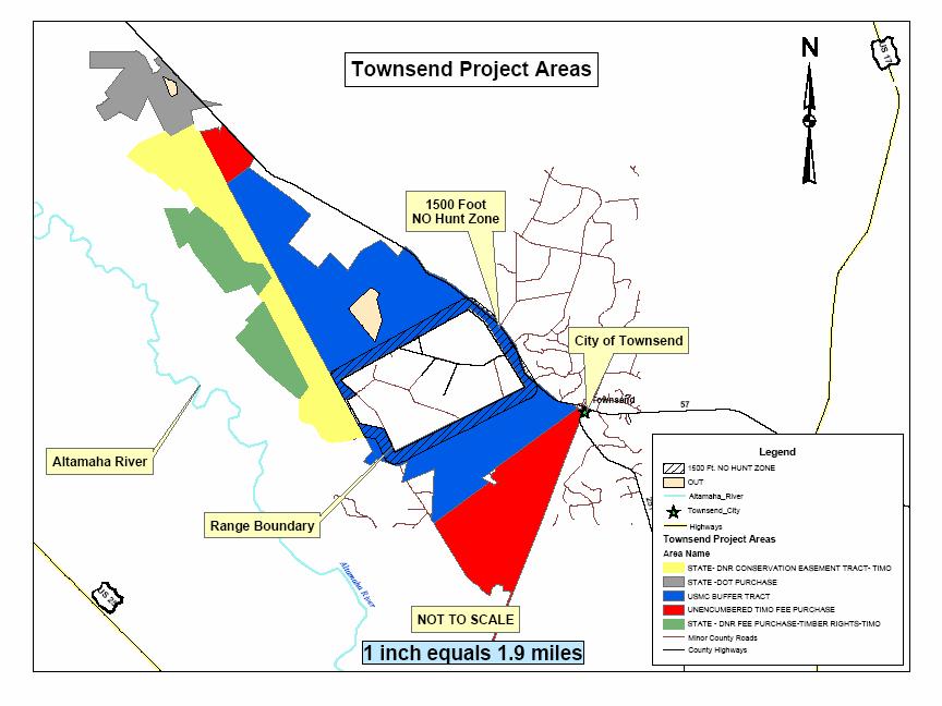
4 Townsend Bombing Range Townsend Bombing Range located in southeast Georgia 5,183 acre air-to-ground range for inert (nonexplosive) ordnance Owned by USMC (MCAS Beaufort) Operated by Georgia Air National Guard (GA ANG) Primary user is MAG 31 Also serves 19 users from five states including ANG, USAF, USAFR, USAN USNR, and Army

5 Coastal Air space Complex


6 Townsend Bombing Range

7 Townsend Bombing Range
8 Encroachment Control Plan MCAS Beaufort and Townsend Bombing Range selected for Prototype Encroachment Control Plan in 2006 ECP recommended promoting mutual interest in preserving the Altamaha River ecosystem Long and McIntosh Counties grew by 66% and 26% from 1990 to 2000 Altamaha River Conservation Forum established The Nature Conservancy, Georgia Department of Natural Resources, U.S. Fish and Wildlife, etc.

9 Encroachment Partnering 2006 International Paper sold 218,000 acres to The Nature Conservancy and the Conservation Fund largest private sale of land in the South 24,120 acres in Georgia
10 Encroachment Partnering

11 Altamaha River area
12 Encroachment Partnering TNC Brokers 24,000 Acre purchase from International Paper Company in 2006 Overarching deal with multiple partners with opportunity for bargain rate for USMC Signed purchase agreement with The Nature Conservancy to acquire a 10,687 acre easement adjacent to Townsend Bombing Range for the Marine Corps 2006

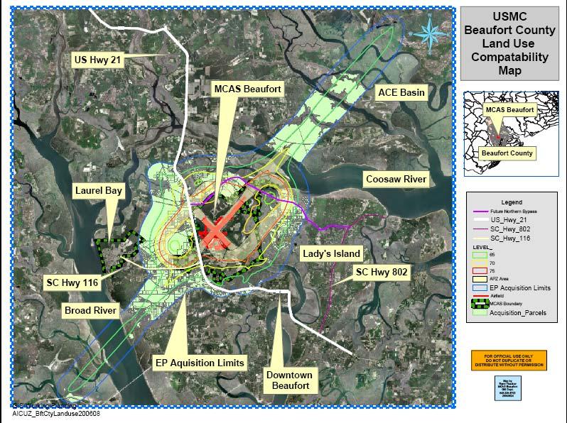
13 MCAS Beaufort Noise Zones NZ-3 NZ-2 NZ-1

14 MCAS Beaufort Accident Potential Zones
15 Joint Land Use Study JLUS endorsed by the three municipal jurisdictions, 2004 JLUS Implementation Committee met May-Oct 2006 with reps from Chamber, real estate board, planners, and MCAS Beaufort Beaufort County, City of Beaufort and Town of Port Royal all adopted identical ordinances week of 11 Dec 2006 Consistent no more zoning shopping Public education program and notification via AICUZ footprint identified on property records via GIS Improved real estate disclosure statements and included renters Density and uses Next goal is Transfer of Development Rights (TDR) program throughout the county
16 Encroachment Planning
17 Encroachment Control Plan MCAS Beaufort selected for Prototype Encroachment Control Plan in 2006 Beaufort County is fastest growing county in South Carolina ECP identified approximately 3000 acres For EP initiative For MILCON Land Acquisition For Minor MLCON Land Acquisition
18 Encroachment Partnering MCAS Beaufort Partners include Beaufort County with Trust for Public Lands Multi-year MOA signed in 2006 with Beaufort County Draft MOA with City of Beaufort Approximately 50/50 MOA Low Country Conservation Forum Beaufort Open Land Trust, Trust for Public Lands, SC Department of Natural Resources, etc.
19
20 Encroachment Partnering MCAS Beaufort 4 EP/REPI Projects, FY-04/05 Battey/Wilson: 64 Acres Rathbun: 28 Acres Lucky: 71 acres REPI: 23% USMC: 21% County: 56% Winn: 69 acres USMC: 34% County: 66% Amgray: 21 acres located in the AICUZ Beaufort County Conservation Easement Donation, no DoD or USMC funds

21 Encroachment Properties FY 04 FY05

22 Point of Contact Alice Howard Community Plans & Liaison Office (843)
2016 Rural and Critical Land Preservation Program Annual Report
 2016 Rural and Critical Land Preservation Program Annual Report Preserving our greenways, waterways, and way of life BEAUFORT COUNTY OPEN LAND TRUST Rural and Critical Land Preservation Program KEEPING
Joint Land Use Study Implementation Technical Committee Meeting May 7, 2014
 Joint Land Use Study Implementation Technical Committee Meeting May 7, 2014 Naval Air Station Joint Reserve Base, New Orleans Belle Chasse, Louisiana Agenda Review and approve 4/14/14 minutes Review Policy
Mitigation and Conservation Banking
 Mitigation and Conservation Banking Ryan Orndorff Headquarters, Marine Corps Marine Corps Installations Command 571-256-2782 ryan.orndorff@usmc.mil Definitions, Policies & Guidelines Existing banks and
Why Are We Here? What is a Military Installation Overlay Zone? Boundaries/Area Impacted Requirements for Safety, Noise, and Height
 Why Are We Here? What is a Military Installation Overlay Zone? Boundaries/Area Impacted Requirements for Safety, Noise, and Height What is the Military Installation Overlay Zoning Map Amendment? Application
Absent: Major Chris Hanson, Volk Field John Ross, Jackson County Emergency Management; Paul Wydeven, Wisconsin Department of Transportation
 Monroe County/Fort McCoy Joint Land Use Study (JLUS) Technical Advisory Group (TAG) December 8, 2011, 2:00 4:00 p.m. Angelo Town Hall, 14123 Co. Hwy. I, Sparta, WI Meeting Minutes Attendance: Bryan Law,
Article 3: Specific to Zones
 Article 3: Specific to Zones Content Page # Division 3.1: Establishment and Designation of Zones 3-1 3.1.10 Purpose 3-1 3.1.20 Establishment of Zones 3-1 3.1.30 Transect Zones 3-1 3.1.40 Overlay Zones
For More Information
 THE ARTS CHILD POLICY CIVIL JUSTICE EDUCATION ENERGY AND ENVIRONMENT This PDF document was made available from www.rand.org as a public service of the RAND Corporation. Jump down to document6 HEALTH AND
Fort A. P. Hill Army Compatible Use Buffer Program DoD/EPA/States Region III Environmental Colloquium Terry Banks 31 October 2007
 Fort A. P. Hill Army Compatible Use Buffer Program DoD/EPA/States Region III Environmental Colloquium Terry Banks 31 October 2007 Fort A.P. Hill Fort A. P. Hill exists to operate a regional center providing
Public Information Meeting: Mattapany Rural Legacy Area - Proposed Expansion
 Public Information Meeting: Mattapany Rural Legacy Area - Proposed Expansion What is the Rural Legacy Program? Maryland s Rural Legacy Program provides funding to: preserve large, contiguous tracts of
CURRENT THROUGH PL , APPROVED 11/11/2009
 CURRENT THROUGH PL 111-98, APPROVED 11/11/2009 TITLE 10. ARMED FORCES SUBTITLE A. GENERAL MILITARY LAW PART IV. SERVICE, SUPPLY, AND PROCUREMENT CHAPTER 159. REAL PROPERTY; RELATED PERSONAL PROPERTY; AND
10 USC 2684a. NB: This unofficial compilation of the U.S. Code is current as of Jan. 4, 2012 (see
 TITLE 10 - ARMED FORCES Subtitle A - General Military Law PART IV - SERVICE, SUPPLY, AND PROCUREMENT CHAPTER 159 - REAL PROPERTY; RELATED PERSONAL PROPERTY; AND LEASE OF NON-EXCESS PROPERTY 2684a. Agreements
Article 4. Zoning Districts
 Section 4.1: Establishment of Districts Article 4. Zoning Districts 4.1 Establishment of Districts For the purpose of this UDO, portions of the City as specified on the Official Zoning Map of the City
MEETING SUMMARY TDR/PDR Multi-Stakeholder Work Group
 MEETING SUMMARY TDR/PDR Multi-Stakeholder Work Group Wednesday January 3, 2018, 2:30-4:30 PM Planning and Development Services Annex Conference Room Attendees Members Perspective Present Chris Behee City
125 Gata Dr 125 Gata Dr, Statesboro, GA 30458
 EXECUTIVE SUMMARY, Statesboro, GA 30458 OFFERING SUMMARY Sale Price: $1,000,000 Cap Rate: 9.12% NOI: $91,200 PROPERTY OVERVIEW Six-year-old restaurant building. Very strong user signed new 5-year lease
Evaluating and Processing Road and Utility Easement Proposals on Corps Lands and Flowage Easements
 Evaluating and Processing Road and Utility Easement Proposals on Corps Lands and Flowage Easements Don Wiese Natural Resources Manager Fort Worth District September 13, 2017 US Army Corps of Engineers
REAL ESTATE PLAN APPENDIX G
 Pacific Ocean Division REAL ESTATE PLAN APPENDIX G Alaska District UNALASKA (DUTCH HARBOR) CHANNELS UNALASKA, ALASKA Real Estate Division Alaska District U.S. Army Corps of Engineers TABLE OF CONTENTS
COMPLIANCE WITH THIS PUBLICATION IS MANDATORY
 BY ORDER OF THE SECRETARY OF THE AIR FORCE AIR FORCE INSTRUCTION 32-9001 28 SEPTEMBER 2017 Civil Engineering ACQUISITION OF REAL PROPERTY COMPLIANCE WITH THIS PUBLICATION IS MANDATORY ACCESSIBILITY: Publications
How Georgia Helped A Fast Growth County Capture Pristine Forest Land While Creating a Model for Other Communities
 How Georgia Helped A Fast Growth County Capture Pristine Forest Land While Creating a Model for Other Communities Fast growing communities face at least two major challenges: ensuring that infrastructure
 As Amended by the Planning Commission June 16, 2005 CONDITIONS OF APPROVAL TENTATIVE PARCEL MAP APPLICATION NO. 2002-28 NANCY ABDALLAH Department of Public Works 1. The recorded parcel map shall be prepared
SHOPPES AT MIDTOWN 864 PARRIS ISLAND GATEWAY BEAUFORT, SC Vonnie Majewski, CCIM Partner
 SHOPPES AT MIDTOWN BEAUFORT, SC 29935 Vonnie Majewski, CCIM Partner 843.338.1799 vonnie.majewski@svn.com SVN GASC 1538 FORDING ISLAND ROAD, SUITE 107, HILTON HEAD ISLAND, SC 29926 OFFERING MEMORANDUM Property
CHAPTER 21 GRANTING OF EASEMENTS TABLE OF CONTENTS. Paragraph Title Page SECTION I - GENERAL
 CHAPTER 21 GRANTING OF EASEMENTS TABLE OF CONTENTS Paragraph Title Page SECTION I - GENERAL 1. Naval Facilities Engineering Command Responsibility for Easements... 21-1 2. References... 21-1 3. Policy...
Conservation Partnering Opportunities for Military Departments, Public Agencies, and Private Conservators
 Conservation Partnering Opportunities for Military Departments, Public Agencies, and Private Conservators Richard A. Engel Naval Facilities Engineering Command April 9, 2003 1 INTRODUCTION Military departments,
RETAIL PAD FOR SALE OR LAND LEASE
 Retail Pad for Sale or Land Lease 215 E. Sunshine, Springfield, MO 65807 Retail Pad site available for sale or land lease on East Sunshine just east of Campbell Located half a block from Bass Pro Shops
January 28, Parcel sale. Proposed Clarks Creek Property Sale. Potential sale of acres 8/27/2015
 Proposed Clarks Creek Property Sale January 28, 2015 Potential sale of 383.8 acres CRW The Conservation Fund PA Game Commission The Conservation Fund is Fort Indiantown Gap selected partner Using Fort
JOINT LAND USE STUDY IMPLEMENTATION NAS JRB NEW ORLEANS
 ---MEETING MINUTES--- Adopted 4/14/14 Technical Group Meeting March 13, 2014, 4:00pm 5:30pm Plaquemines Parish Library, 8442 Louisiana 23, Belle Chasse, LA Participants: Diana Alfortish Pivach Real Estate
MINUTES OF THE ST. MARY S COUNTY PLANNING COMMISSION MEETING ROOM 14 * GOVERNMENTAL CENTER * LEONARDTOWN, MARYLAND Monday, June 25, 2007
 MINUTES OF THE ST. MARY S COUNTY PLANNING COMMISSION MEETING ROOM 14 * GOVERNMENTAL CENTER * LEONARDTOWN, MARYLAND Monday, June 25, 2007 Members present were Stephen Reeves, Chair; Howard Thompson, Lawrence
Town of Surf City. City Council Presentation April 2, 2013 PETER A. RAVELLA, PRINCIPAL PAR CONSULTING, LLC
 Town of Surf City City Council Presentation April 2, 2013 PETER A. RAVELLA, PRINCIPAL CONSULTING, LLC I. Review Workshop schedule & Input SC-NTB Federal Project Plan 1550 Funding Contributors You re Not
2018 JMGBL Awards Application
 2018 JMGBL Awards Application Submission Date 2018-06-21 10:41:59 This application is for: Project Title County/Counties Staff Contact Job Title E-mail Address J. Mitchell Graham Memorial Award The Independent
Project Charter Project Name: Conservation Subdivision Review
 Project Charter Project Name: Conservation Subdivision Review Creation Date: June 19, 2013 Last Updated: June 27, 2013 Version: 1 Purpose The purpose of this project is to review the subdivision regulations
Westside MHP HIGHWAY 80 WEST, Statesboro, GA 30458
 EXECUTIVE SUMMARY OFFERING SUMMARY Sale Price: Number Of Units: PROPERTY OVERVIEW $149,500 23 Cap Rate: 10.16% NOI: $15,190 Lot Size: Building Size: 10.62 Acres 1,344 Tons of upside here. 23 spaces. 3
Orangeburg Rental Home Porftolio 1065 Freeland Street, Orangeburg, SC 29115
 EXECUTIVE SUMMARY OFFERING SUMMARY Sale Price: $240,000 Number Of Units: 4 Cap Rate: 8.1% NOI: $19,434 Lot Size: 0.0 Acres Building Size: 5,000 PROPERTY OVERVIEW 4 Rental houses for sale. owner purchased
Land Use Study for Wheeler Estates
 Land Use Study for Wheeler Estates BOARD OF COUNTY COMMISSIONERS TRANSMITTAL HEARING TUESDAY, MARCH 26, 2019 HENDRY COUNTY COURTHOUSE LABELLE, FLORIDA 1 Wheeler Estates Study Area Approximately 1,933 acres
Winn Dixie new 20 year NNN lease
 Subject Property Phone: 212.972.7457 Fax: 212.686.0078 exp@exp1031.com www.exp1031.com Exclusive Offering In Connection With: Winn Dixie new 20 year NNN lease 1625 West Tharpe Street - Tallahassee, FL
For Lease. Center Oak Plaza 1119 Johnnie Dodds Blvd Mount Pleasant, South Carolina LOCATED IN THE HEART OF MOUNT PLEASANT
 For Lease Center Oak Plaza 1119 Johnnie Dodds Blvd Mount Pleasant, South Carolina 29464 LOCATED IN THE HEART OF MOUNT PLEASANT For More Information, Contact: Vitré Ravenel Stephens Senior Vice President
Staff Planner Carolyn A.K. Smith
 Applicant Property Owner, Pamela K. & Steven A. Gray Public Hearing April 13, 2016 City Council Election District Princess Anne Agenda Item 8 Request Modification of Proffers (Modification to the proffer
Request Conditional Use Permit (Bulk Storage Yard) Staff Recommendation Approval. Staff Planner Robert Davis
 Staff Recommendation Approval. Staff Planner Robert Davis") Applicant Property Owner Glaser, LLC Public Hearing March 14, 2018 City Council Election District Rose Hall Agenda Item 5 Request Conditional Use Permit (Bulk Storage Yard) Staff Recommendation Approval
Applicant Property Owner Glaser, LLC Public Hearing March 14, 2018 City Council Election District Rose Hall Agenda Item 5 Request Conditional Use Permit (Bulk Storage Yard) Staff Recommendation Approval
ACQUISITION, MANAGEMENT, AND DISPOSAL OF REAL PROPERTY AND REAL PROPERTY INTERESTS BY THE DEPARTMENT OF THE NAVY
 SECNAV INSTRUCTION 11011.47C DEPARTMENT OF THE NAVY OFFICE OF THE SECRETARY 1000 NAVY PENTAGON WASHINGTON DC 20350 1 000 ASN EI&E From: Subj: Secretary of the Navy ACQUISITION, MANAGEMENT, AND DISPOSAL
NEWPORT CODE DRAFT latest revision 11/11/13 APPENDIX A. SPECIAL USE and CONDITIONAL USE PERMITS
 PROVISIONS FOR SPECIAL and CONDITIONAL USES 9-6 Tall Structures, General Tall Structures are defined as but not limited to: Steeples, Towers, Smoke Chimneys, Wind activated Devices, Wind Energy Facilities
For Lease. Center Oak Plaza 1119 Johnnie Dodds Blvd Mount Pleasant, South Carolina LOCATED IN THE HEART OF MOUNT PLEASANT
 For Lease Center Oak Plaza 1119 Johnnie Dodds Blvd Mount Pleasant, South Carolina 29464 LOCATED IN THE HEART OF MOUNT PLEASANT For More Information, Contact: Vitré Ravenel Stephens Vice President Retail
Dredged Material Management Plan Atlantic Intracoastal Waterway Port Royal Sound, South Carolina to Cumberland Sound, Georgia November 2015
 Dredged Material Management Plan Atlantic Intracoastal Waterway Port Royal Sound, South Carolina to Cumberland Sound, Georgia November 2015 Appendix H: Real Estate US Army Corps of Engineers South Atlantic
Olsen, Vic and Mae, Civilian Conservation Corps Collection,
 Olsen, Vic and Mae, Civilian Conservation Corps Collection, 1930-2001 Overview of the Collection Creator Olsen, Victor T.; Olsen, Mae C. Title Olsen, Vic and Mae, Civilian Conservation Corps Collection
Broadway Corridor Planning Program
 Broadway Corridor Planning Program 1. Status and Timing 2. Proposed Approach to Curbing Land Speculation 3. Interim Rezoning Policy Stakeholder Information Session: May 22nd 2018 Presentation Overview
St. Joe Timberland. Climate Change Lands. Bay, Walton Washington, Gadsden, Liberty, Gulf, Franklin, Wakulla, Leon, Jefferson and Taylor Counties
 Bay, Walton Washington, Gadsden, Liberty, Gulf, Franklin, Wakulla, Leon, Jefferson and Taylor Counties St. Joe Timberland Climate Change Lands Purpose for State Acquisition The St. Joe Company is one of
Tools for Conservation: Land Trusts & Easements
 Tools for Conservation: Land Trusts & s CSS 235 Dr. Ed Krumpe 2 4 Basic Ways to Protect Land Acquisition the only permanent solution? Regulation Protect sensitive areas Control development patterns Address
Rough River Lake Flowage Easement Encroachment Resolution:
 Rough River Lake Flowage Easement Encroachment Resolution: Rough River Lake Louisville District LRD November 2017 US Army Corps of Engineers Why are we here? Summarize the Flowage Easement Encroachment
Defense Logistics Agency INSTRUCTION
 Defense Logistics Agency INSTRUCTION DLAI 4165.01 Effective June 10, 2013 DS SUBJECT: Acquisition and Disposal of Real Estate References: Refer to Enclosure 1. 1. PURPOSE. This Instruction describes Defense
TRANSFER OF SURPLUS PROPERTIES USING NEW LEGISLATIVE AUTHORITIES
 TRANSFER OF SURPLUS PROPERTIES USING NEW LEGISLATIVE AUTHORITIES Harry H. Zimmerman Jr., PE Marstel Day, LLC (Formerly BAHR Environmental Company) NDIA 29 th Annual Environmental & Energy Symposium & Exhibition
TransNet Environmental Mitigation Program: Land Acquisition and Restoration Process and Criteria
 TransNet Environmental Mitigation Program: Land Acquisition and Restoration Process and Criteria On September 26, 2008, the San Diego Association of Governments Board of Directors (BOD) approved the attached
OFFERING MEMORANDUM. Available: Advance Auto Parts
 Available: Advance Auto Parts OFFERING MEMORANDUM Freestanding Building Largest Populated City in Florida (5) Years remaining on 15 year Lease Income Tax Free State Jacksonville, FL NORTH FLORIDA / DUVAL
COMPLIANCE WITH THIS PUBLICATION IS MANDATORY (USAFE)
") BY ORDER OF THE SECRETARY OF THE AIR FORCE AIR FORCE INSTRUCTION 32-9001 27 JULY 1994 UNITED STATES AIR FORCES IN EUROPE Supplement 9 AUGUST 2012 Certified Current on 27 July 2016 Civil Engineering ACQUISITION
BY ORDER OF THE SECRETARY OF THE AIR FORCE AIR FORCE INSTRUCTION 32-9001 27 JULY 1994 UNITED STATES AIR FORCES IN EUROPE Supplement 9 AUGUST 2012 Certified Current on 27 July 2016 Civil Engineering ACQUISITION
Private Land Conservation: Conservation Easements. Matt Singer Land Stewardship Manager
 Private Land Conservation: Conservation Easements Matt Singer Land Stewardship Manager Galveston Bay Foundation Mission: To preserve, protect, and enhance the natural resources of the Galveston Bay estuarine
Transfer of Development Rights
 Ordinance Transfer of Development Rights King County s (WA) 2008 ordinance establishes a transfer of development rights program. The ordinance: Sets eligibility criteria for sending and receiving sites
THE MUNICIPALITY OF TRENT LAKES
 THE MUNICIPALITY OF TRENT LAKES Minutes of a Public Meeting Held Pursuant to Section 34 Of The Planning Act held on in The Council Chambers at the Municipal Office Call to Order Present: Mayor Bev Matthews
The Multipurpose Marine Cadastre A Tool for Planning & Decision Making in the Marine Environment
 The Multipurpose Marine Cadastre A Tool for Planning & Decision Making in the Marine Environment Christine Taylor Minerals Management Service (MMS) Brian Smith NOAA Coastal Services Center Maurice Hill
Transfer of Development Rights. February 13, 2017
 Transfer of Development Rights City Council Meeting February 13, 2017 Overview What were working on Transfer of Development Rights King County / COS Interlocal TDR Regulations Q & A Transfer of Development
Section 4(f) Why don t we build the road through this green space over here?
 Why don t we build the road through this green space over here?") Section 4(f) Why don t we build the road through this green space over here? Objectives Section 4(f) What is Section 4(f)? understand the basics of the law and applicability; Is this a Section 4(f) situation?--develop
Section 4(f) Why don t we build the road through this green space over here? Objectives Section 4(f) What is Section 4(f)? understand the basics of the law and applicability; Is this a Section 4(f) situation?--develop
Program Data Table Item 13. Adjusted Special Flood Hazard Area (asfha) GOAL:
 GOAL:") Community Rating System analysis procedure Wednesday, September 15, 2015 Prepared by Laura Gibson, reviewed by Mike Dumais and Beth Yang Program Data Table Item 13. Adjusted Special Flood Hazard Area (asfha)
Community Rating System analysis procedure Wednesday, September 15, 2015 Prepared by Laura Gibson, reviewed by Mike Dumais and Beth Yang Program Data Table Item 13. Adjusted Special Flood Hazard Area (asfha)
Information. Permit Request by Alva & Antonio Mascorro to build a new dwelling at 213 Gyna, Val Verde County, Texas
 1 Joint Airport Zoning Board 4. Meeting Date: 04/03/2013 Submitted By: Janice Pokrant, Engineering Department SUBJECT: Information Permit Request by Alva & Antonio Mascorro to build a new dwelling at 213
FINDINGS OF FACT. Page 1 of 8
 FINDINGS OF FACT The City/County Planning staff has prepared the Findings of Fact for the Emerald View Park Subdivision, Amended Lot 1A, Block 3. These findings are based on the preliminary plat application
SARASOTA COUNTY GOVERNMENT
 SARASOTA COUNTY GOVERNMENT Parks, Recreation and Natural Resources TO: Sarasota County Commission THROUGH: Jonathan R. Lewis, County Administrator FROM: Carolyn Brown, Director, Parks, Recreation and Natural
City Council Study Session Agenda Puyallup City Council Chambers 333 S Meridian, Puyallup Tuesday, February 5, :30 PM
 City Council Study Session Agenda Puyallup City Council Chambers 333 S Meridian, Puyallup 98371 Tuesday, February 5, 2019 6:30 PM PLEDGE OF ALLEGIANCE ROLL CALL APPROVAL OF THE AGENDA 1. AGENDA ITEMS 1.a
Protecting Wild & Scenic River Values Through Land Conservation
 Protecting Wild & Scenic River Values Through Land Conservation RMS & NARRP Symposium Bridging Conservation and Recreation May 20, 2010 Portland, Oregon Phil Kincare Skagit Wild & Scenic River Mt. Baker-Snoqualmie
APPENDIX D REAL ESTATE PLAN
 APPENDIX D REAL ESTATE PLAN APPENDIX D REAL ESTATE PLAN TABLE OF CONTENTS 1. STATEMENT OF PURPOSE 2. REFERENCES 3. AUTHORIZATION 4. BACKGROUND 5. LOCATION 6. REAL ESTATE REQUIREMENTS 7. OWNERSHIP OF REAL
Offering Memorandum BURGER KING 3368 RAILROAD AVENUE BAMBERG, SC 29003
 Offering Memorandum BURGER KING 3368 RAILROAD AVENUE BAMBERG, SC 29003 CONTENTS 03 04 06 08 EXECUTIVE SUMMARY FINANCIAL OVERVIEW TENANT OVERVIEW AREA OVERVIEW LISTED BY Gary Chou SVP & SENIOR Director
RESOLUTION NO WHEREAS, an airport land use report was subsequently prepared by Johnson Aviation for the City of Perris; and
 RESOLUTION NO. 4202 A RESOLUTION OF THE CITY COUNCIL OF THE CITY OF PERRIS, COUNTY OF RIVERSIDE, STATE OF CALIFORNIA, OVERRULING THE RIVERSIDE COUNTY AIRPORT LAND USE COMMISSION (ALUC) FINDING OF INCONSISTENCY
Methods Used in Pricing & Conveying NASA Assets for Use by Commercial Programs
 Methods Used in Pricing & Conveying NASA Assets for Use by Commercial Programs JIM ROBERTS & TERRY LAMBING NASA Kennedy Space Center Office of the CFO 2015 ICEAA Professional Development and Training Workshop
Marine Corps Resident Energy Conservation Program (RECP) MCCS Cherry Point
 MCCS Cherry Point") Marine Corps Resident Energy Conservation Program (RECP) MCCS Cherry Point 1 Welcome Agenda Col Zimmerman Command Representative Program Briefing AMCC Video Questions and Answers 2 Resident Energy Conservation
Marine Corps Resident Energy Conservation Program (RECP) MCCS Cherry Point 1 Welcome Agenda Col Zimmerman Command Representative Program Briefing AMCC Video Questions and Answers 2 Resident Energy Conservation
RESTAURANT PROPERTY FOR SUBLEASE
 Restaurant Building for Sublease 1112 W Jackson St, Ozark, MO 65721 RESTAURANT PROPERTY Building is occupied - shown by appointment only Many nearby local and national retailers Located just a few blocks
BY ORDER OF THE AIR FORCE HANDBOOK SECRETARY OF THE AIR FORCE 1 MAY Civil Engineering MANAGING AIR FORCE REAL PROPERTY
 BY ORDER OF THE AIR FORCE HANDBOOK 32-9007 SECRETARY OF THE AIR FORCE 1 MAY 1999 Civil Engineering MANAGING AIR FORCE REAL PROPERTY NOTICE: This publication is available on the AFDPO WWW site at: http//afpubs.hq.af.mil.
What does the New Land Use Handbook have to offer?
 What does the New Land Use Handbook have to offer? 2006 AirTAP Fall Forum Kathy Vesely, Gina Mitchell 1 New Legislation 2 SF 1940 Effective August 1, 2006 The operation and maintenance of airports is an
City of Burlington Joint Land Use Board. Land Use Development Application Application Submission Section A
 City of Burlington Joint Land Use Board Land Use Development Application Application Submission Section A Documents must be included in all application packages Land Use Development Application Affidavit
STAFF REPORT TO THE COMMISSION. April 7, Rezoning Case No
 STAFF REPORT TO THE COMMISSION April 7, 2014 REQUEST: Fridie Dickerson requests the rezoning of a parcel 5.0 gross acres in size from Rural Area-40 acre minimum (RA-40) to Rural Area-5 acre minimum (RA-5),
Pass Rd Biloxi, MS MATTHEWS REAL ESTATE INVESTMENT SERVICES
 S H O P P I N G C E N T E R 2374-2390 Pass Rd Biloxi, MS O F F E R I N G M E M O R A N D U M S H O P P I N G C E N T E R 2374-2390 Pass Rd Biloxi, MS 39531 JORDAN POWELL associate Shopping Centers Direct
Housing Supply Overview
 Housing Supply Overview A RESEARCH TOOL PROVIDED BY SOUTH CAROLINA REALTORS April 2016 We should see a healthy number of sales in most categories for the next few months, yet there is still some lingering
VERIZON WIRELESS & CLEAR CHANNEL BILLBOARD. $2,470,000 / 8.2% CAP (8.95% in 2013)
") Dobbins Air Reserve Base Subject Property Subject Property Akers Mill Square Cumberland Mall Subject Property VERIZON WIRELESS & CLEAR CHANNEL BILLBOARD 2009 Construction $2,470,000 / 8.2% CAP (8.95% in
Dobbins Air Reserve Base Subject Property Subject Property Akers Mill Square Cumberland Mall Subject Property VERIZON WIRELESS & CLEAR CHANNEL BILLBOARD 2009 Construction $2,470,000 / 8.2% CAP (8.95% in
NWS Seal Beach Detachment Concord. Department of the Navy Base Realignment and Closure Program Management Office Laura Duchnak October 10, 2006
 NWS Seal Beach Detachment Concord Department of the Navy Base Realignment and Closure Program Management Office Laura Duchnak October 10, 2006 BRAC Program Management Office ASN (I&E) BJ Penn DASN (I&F)
Bandera Corridor Conservation Bank: a conservation story
 Bandera Corridor Conservation Bank: a conservation story 2016 Golden-cheeked Warbler and Black-capped Vireo Symposium January 28, 2016 What is a Conservation Bank? A site or suite of sites containing natural
Plan of Survey (Feature Plans)
") October 4, 2014 Plan of Survey (Feature Plans) NOTE: This document is a Controller of Surveys Policy manual to be used as a general guideline for the preparation and examination of plans. Reference should
October 4, 2014 Plan of Survey (Feature Plans) NOTE: This document is a Controller of Surveys Policy manual to be used as a general guideline for the preparation and examination of plans. Reference should
FURY'S FERRY OFFICE SPACE
 Fury's Ferry Medical Office Space FURY'S FERRY OFFICE SPACE President & Broker EXECUTIVE SUMMARY OFFERING SUMMARY Available SF: Lease Rate: Lot Size: 2,700-16,200 SF Negotiable 1.39 Acres PROPERTY OVERVIEW
Tiered Environmental Review Format (2017)
") Tiered Environmental Review Format (2017) This tiered review format [per 24CFR 58.15] is designed to be used for activities that are categorically excluded [per 24CFR 58.35(a)] subject to the laws and
Tiered Environmental Review Format (2017) This tiered review format [per 24CFR 58.15] is designed to be used for activities that are categorically excluded [per 24CFR 58.35(a)] subject to the laws and
Citizens Advisory Committee Meeting
 Citizens dvisory Committee Meeting for the NORTH EMBRCDERO PORT MSTER PLN MENDMENT and DRFT ENVIRONMENTL IMPCT REPORT March 16, 2011 1 Revised Notice of Preparation - Scoping Session for the NORTH EMBRCDERO
DEVELOPMENT LAND FOR SALE
 Vacant Land for Sale Hwy 14 & 25th St., Ozark, MO 65721 Mixed-use development lots for sale in Ozark, Missouri Ideal retail and office development location Adjacent to the new Ozark B&B Theater on Highway
Date: June 17, Recreation and Park Commission. Dawn Kamalanathan Planning Director
 Date: June 17, 2010 To: From: Recreation and Park Commission Dawn Kamalanathan Planning Director Subject: Candlestick Point Hunters Point Shipyard Phase 2 Project Agenda Wording: Resolution approving and
MSK HIGHWAYS 46 & 170
 HIGHWAYS & PARCEL SIZE: ±25.68 acres available either in whole or as 6 individual parcels ranging in size from 1.4 to 15.9 acres.. RETAIL LAND PARCELS Beaufort ZONING: Commercial under the jurisdiction
MS MINOR SUBDIVISION TREVITHICK
 MS-02-015 341.12 MINOR SUBDIVISION TREVITHICK A request by Danny Trevithick for a one-lot Minor Subdivision on five acres. The property is zoned A-35 (Agricultural) District and is located ¼ mile south
Public Law th Congress An Act
 114 STAT. 2563 Public Law 106 538 106th Congress An Act To establish the Las Cienegas National Conservation Area in the State of Arizona. Be it enacted by the Senate and House of Representatives of the
Natural Resource Conservation Service, Wetland Reserve Program National Review Appraiser
 William Moran, RAA, GAA, Certified General Appraiser #70815 The Island s only Residential Accredited, General Accredited and Certified General Appraiser maintaining a full time office on the island of
Housing Supply Overview
 Housing Supply Overview A RESEARCH TOOL PROVIDED BY SOUTH CAROLINA REALTORS May 2016 Sellers are getting more of their asking price, meaning higher sales prices in most categories. The overall inventory
Buchanan Landings. West Bay, FL Lisa Felix, Broker Full Sail Realty of NWFL
 Buchanan Landings West Bay, FL 2010 Lisa Felix, Broker Full Sail Realty of NWFL 850-819-4961 LisaFelixCanSellit@yahoo.com www.investinwestbay.com Executive Summary Approximately 26 +/- acres of Bay-Front
Application Procedures for Easements or Rights of Way on City of Fort Collins Natural Areas and Conserved Lands March 2012
 Application Procedures for Easements or Rights of Way on City of Fort Collins Natural Areas and Conserved Lands March 2012 IMPORTANT NOTE: This document was created to accompany the City of Fort Collins
Introduction to INRMP Implementation Options
 El Dorado County Integrated Natural Resources Management Plan Introduction to INRMP Implementation Options 1 Our approach to the options evaluation is based on the INRMP components as they are currently
VALLE RESEDA 216 ACRES RESIDENTIAL LAND AVAILABLE FOR SALE
 N. SANDERSON AVENUE RAMONA EXPRESSWAY N. RAMONA BOULEVARD VALLE RESEDA 216 ACRES RESIDENTIAL LAND AVAILABLE FOR SALE 1. EXECUTIVE SUMMARY 2. PROPERTY INFORMATION TABLE OF CONTENTS 3. LOCATION INFORMATION
Preserving Forested Lands
 Preserving Forested Lands Maryland Woodland Stewards October 3, 2014 Megan Benjamin, Western & Central Region Planner Forestlands in Maryland Forests cover 41% of the State 2.6 million acres Ownership
COMMERCIAL LOTS WESTOVER TOWN CENTER NORTHWEST SAN ANTONIO, TEXAS
 COMMERCIAL LOTS WESTOVER TOWN CENTER NORTHWEST SAN ANTONIO, TEXAS LOCATION: SIZE/ INVESTMENT: FRONTAGE: The lots are located at the southeast quadrant of Highway 151 and Westover Hills Boulevard. See Lot
No Land, No Water: Solutions and Programs for Mitigating Land Loss
 No Land, No Water: Solutions and Programs for Mitigating Land Loss Alamo Area Council of Governments Blair Calvert Fitzsimons, Chief Executive Officer Texas Agricultural Land Trust May 27, 2015 1 Outline
TOWN OF MOUNT PLEASANT, SOUTH CAROLINA PLANNING AND DEVELOPMENT COMMITTEE MAY 5, 2014 MINUTES. Municipal Complex - Council Chambers
 TOWN OF MOUNT PLEASANT, SOUTH CAROLINA PLANNING AND DEVELOPMENT COMMITTEE MAY 5, 2014 MINUTES Municipal Complex - Council Chambers Present: Staff: Thomasena Stokes-Marshall, Chair, Chris O'Neal, Elton
CALIFORNIA CODES CIVIL CODE SECTION
 CALIFORNIA CODES CIVIL CODE SECTION 840-848 846. An owner of any estate or any other interest in real property, whether possessory or nonpossessory, owes no duty of care to keep the premises safe for entry
INDUSTRIAL. Acknowledgements. Author: Billy King, SIOR. Data Preparation: Stephanie Sanker. Survey Coordination Clay Culbreth, CCIM, SIOR
 HAMPTON ROADS 2006 INDUSTRIAL M A R K E T S U R V E Y Acknowledgements Author: Billy King, SIOR Data Preparation: Stephanie Sanker Survey Coordination Clay Culbreth, CCIM, SIOR Financial Support: The E.
Venture Oil & Gas Corporate Office
 Venture Oil & Gas Corporate Office Laurel, MS I Hattiesburg, MS PORTOFLIO SALE Venture Oil & Gas 1 Hattiesburg, Laurel, MS MS 2 Offering Memorandum contents 04 EXECUTIVE SUMMARY 06 financial OVERVIEW 08
Developing a Prototype Marine Cadastre for Chedabucto Bay, Nova Scotia, Canada or is it St. Margaret s Bay?
 Developing a Prototype Marine Cadastre for Chedabucto Bay, Nova Scotia, Canada or is it St. Margaret s Bay? Dr. Michael Sutherland, CANADA Chair-Elect, Commission 4 FIG EILAT 2009, FIG WORKING WEEK, EILAT,