ORANGE COUNTY A-1-3 ADOPTION AMENDMENT
|
|
|
- Kory McGee
- 5 years ago
- Views:
Transcription


1 ORANGE COUNTY PLANNING DIVISION A-1-3 ADOPTION AMENDMENT COMPREHENSIVE PLAN BOARD OF COUNTY COMMISSIONERS JANUARY 15, 2019 ADOPTION PUBLIC HEARING PREPARED BY: ORANGE COUNTY COMMUNITY, ENVIRONMENTAL AND DEVELOPMENT SERVICES PLANNING DIVISION COMPREHENSIVE PLANNING SECTION

2

3
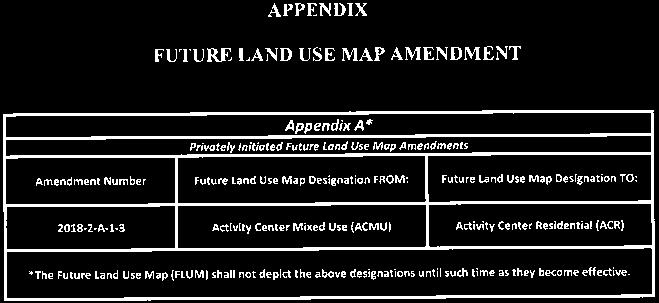
4 TABLE OF CONTENTS Introduction... Tab 1 Regular Cycle Amendments... Tab 2 Privately Initiated Regular Cycle Future Land Use Map (FLUM) Amendment Amendment A 1 3 World Resort Activity Center Mixed Use (ACMU) to Activity Center Residential (ACR) Page and Substantial Change CDR Substantial Change Request to the World Resort PD to add Activity Center Residential (ACR) uses; to convert 696 hotel rooms to 650 multi family units; to add trip equivalencies for multi family uses; and to remove Board of County Commissioners Condition of Approval #9 from May 9, 2006 Also requested are two (2) waivers from Orange County Code: 1) a waiver from Sec (j) to allow a minimum building separation of twenty (20) feet between all multi family buildings with no increase in proportion to additional structural height, in lieu of thirty (30) feet for two story buildings and forty (40) feet for three story buildings and separation increase in proportion to additional structural height; and, 2) a waiver from Sec to allow for a maximum height of seventy five (75) feet in lieu of sixty (60) feet. 1 State Agencies Comments/ORC Report and Response..Tab 3 Community Meeting Summaries..Tab 4 Facilities Analyses...Tab 5 Transportation Analyses.Tab 6 Environmental Analyses.Tab 7 BCC Adoption 1 January 15, 2019
5 Session II Regular Cycle State Expedited Review Comprehensive Plan Amendments Privately Initiated Future Land Use Map and Text Amendments Amendment Number Concurrent Rezoning or Substantial Change Owner Agent Tax ID Number(s) General Location / Comments Future Land Use Map Designation FROM: Future Land Use Map Designation TO: Zoning Map Designation FROM: Zoning Map Designation TO: Acreage Project Planner Staff Rec LPA Rec BCC Rec District A-1-1 (Tilden Road) PD Rezoning Pending Daniel A. and Susan Berry/Thistledown Farm, Inc. Kathy Hattaway, Poulos & Bennett, LLC (portion of) and (portion of) and Tilden Rd.; Generally located south of Tilden Rd., west of Winter Garden Vineland Rd., and east of Tiny Rd. and SR 429 Village (V) Horizon West, Village of Bridgewater Special Planning Area (SPA) A-1 (Citrus Rural District) PD (Planned Development District) gross ac./18.54 developable ac. Nicolas Thalmueller A-1-2 (Lake Austin) LUP BB Groves, LLC Kathy Hattaway, Poulos & Bennett, LLC (portion of) and Generally located west of Avalon Rd., and north and south of Grove Blossom Wy. Growth Center/ Resort/Planned Development (GC/R/PD) Growth Center-Planned Development- Resort/Low-Medium Density Residential (GC-PD-R/LMDR) PD (Planned Development District)(Lake Austin PD) and A-2 (Farmland Rural District) PD (Planned Development District)(BB Groves South PD) gross ac./96.29 developable ac. Sue Watson Adopt Adopt (8-1) A-1-3 (World Resort) CDR Fairwinds Credit Union Generally located north and Miranda F. Fitzgerald, south of Poinciana Blvd., east Esq., Lowndes, Drosdick, /741/870/871/880 and of SR 535, south of SR 417, and Doster, Kantor & Reed, north of the Orange/Osceola P.A. County line Activity Center Mixed Use (ACMU) Activity Center Residential (ACR) PD (Planned Development District) (World Resort PD) PD (Planned Development District) (World Resort PD) gross ac. Jennifer DuBois Adopt Adopt (9-0) A-1-4 (Kerina Parkside) CDR Kerina Wildwood, Inc., Kerina Village, Inc., Kerina Inc., and Kerina Parkside Master, Inc. Miranda F. Fitzgerald, Esq., Lowndes, Drosdick, Doster, Kantor & Reed, P.A /053, , /071/130/142, and (portion of) Generally located east and west of S. Apopka-Vineland Rd., south of Buena Vista Woods Blvd., and north of Lake St. Low Density Residential (LDR), Low- Medium Density Residential (LMDR), and Rural/Agricultural (R) Planned Development- Commercial/Office/Medium Density Residential/Low Density Residential/Senior Living/Conservation (PD-C/O/MDR/LDR/Senior Living/CONS) PD (Planned Development District) (Kerina Parkside PD/LUP) PD (Planned Development District) (Kerina Parkside PD/LUP) FLUM Amendment: gross ac.; PD/LUP Substantial Change: gross ac. Jennifer DuBois Adopt Adopt (5-3) A-1-6 (Hannah Smith) CDR Daryl M. Carter Trustee and Carter-Orange 105 Sand Lake Land Trust VHB, Inc , /018, /66-000/ (portion of), and /024 Generally located north of Interstate 4 and south of Fenton St. Activity Center Mixed Use (ACMU), Activity Center Residential (ACR), and Low-Medium Density Residential (LMDR) Planned Development- Commercial/Medium-High Density Residential (PD-C/MHDR) PD (Planned Development District) (Hannah Smith PD) PD (Planned Development District) (Hannah Smith PD) gross ac./79.50 developable ac. Sue Watson Adopt Adopt (9-0) A-1-7 (Turkey Lake Road Condos) CDR Macomb Oakland Sand Lake, LLC Momtaz Barq, P.E., Terra- Max Engineering, Inc Turkey Lake Rd.; Generally located south of Sand Lake Reserve Dr.; east of Big Sand Lake, west of Turkey Lake Rd. Planned Development-Time Share/Medium Density Residential/Hotel/Office (PD- TS/MDR/HOTEL/O) Planned Development-Time Share/Medium-High Density Residential/Hotel/Office (PD-TS/MHDR/HOTEL/O) PD Planned Development District)(Turkey Lake Condos PD) PD (Planned Develiopment District)(Turkey Lake Condos PD) gross ac./16.82 developable ac. Misty Mills Adopt Adopt (9-0) District 1 Text Amendment Number Owner Agent Description of Proposed Text Amendments P-1-5 (Arnold Groves Senior Living) Audrey L. Arnold Revocable Trust, Audrey L. Arnold and James P. Arnold Life Estate, Ron Marlow and Kathy Darlene Marlow, and Billy Kenneth Williams, and Lynn A. Williams Marc Skorman Text amendment to proposed Future Land Use Element Policy FLU2.5.5 and creating Policy FLU related to the proposed Lake Mabel Rural Residential Enclave Nicolas Thalmueller ABBREVIATIONS INDEX: ABBREVIATIONS INDEX: IND-Industrial; C-Commercial; O-Office; LDR-Low Density Residential; LMDR-Low-Medium Density Residential; MDR-Medium Density Residential; MHDR-Medium-High Density Residential; HDR-High Density Residential; PD-Planned Development; V- Village; CONS-Wetland/Conservation; PR/OS-Parks/Recreation/Open Space; OS-Open Space; GB-Greenbelt; SPA-Special Planning Area; R-Rural/Agricultural; TS-Timeshare; RS-Rural Settlement; ACMU-Activity Center Mixed Use; ACR-Activity Center Residential; GC- Growth Center; R-Resort; PD-Planned Development; USA-Urban Service Area; WB-Water Body; CP-Comprehensive Plan; FLUM-Future Land Use Map; FLUE-Future Land Use Element; TRAN-Transportation Element; GOPS-Goals, Objectives, and Policies; OBJ-Objective; LUP- Land Use Plan; LUPA-Land Use Plan Amendment; CDR- Change Determination Request; PD-Planned Development District; A-2- Farmland Rural District; A-1-Citrus Rural District; SR-State Road; AC-Acres Updated on 1/8/ Session II Regular Cycle State Expedited Amendments - Summary Chart Pg. 1 of 2
6 Regular Cycle Comprehensive Plan Amendments Staff Initiated Comprehensive Plan Map and Text Amendments Amendment Number Sponsor Description of Proposed Changes to the Comprehensive Plan (CP) Project Planner Staff Rec LPA Rec BCC Rec B-FLUE-1 Planning Division Text amendment to Future Land Use Element Policy FLU8.1.4 establishing the maximum densities and intensities for proposed Planned Developments within Orange County Misty Mills Adopt Adopt (8-1) B-FLUE-2 Planning Division Text amendment to the Horizon West Village policies for perimeter remnant parcels Maria Cahill ABBREVIATIONS INDEX: ABBREVIATIONS INDEX: IND-Industrial; C-Commercial; O-Office; LDR-Low Density Residential; LMDR-Low-Medium Density Residential; MDR-Medium Density Residential; MHDR-Medium-High Density Residential; HDR-High Density Residential; PD-Planned Development; V- Village; CONS-Wetland/Conservation; PR/OS-Parks/Recreation/Open Space; OS-Open Space; GB-Greenbelt; SPA-Special Planning Area; R-Rural/Agricultural; TS-Timeshare; RS-Rural Settlement; ACMU-Activity Center Mixed Use; ACR-Activity Center Residential; GC- Growth Center; R-Resort; PD-Planned Development; USA-Urban Service Area; WB-Water Body; CP-Comprehensive Plan; FLUM-Future Land Use Map; FLUE-Future Land Use Element; TRAN-Transportation Element; GOPS-Goals, Objectives, and Policies; OBJ-Objective; LUP- Land Use Plan; LUPA-Land Use Plan Amendment; CDR- Change Determination Request; PD-Planned Development District; A-2- Farmland Rural District; A-1-Citrus Rural District; SR-State Road; AC-Acres Updated on 1/8/ Session II Regular Cycle State Expedited Amendments - Summary Chart Pg. 2 of 2
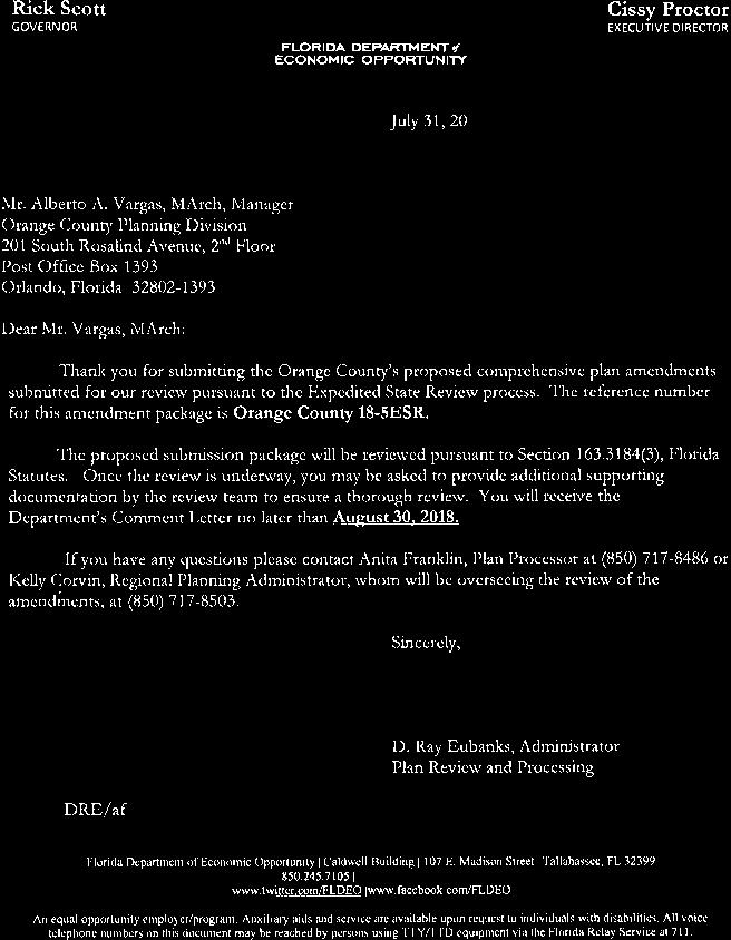
7 2018 SECOND REGULAR CYCLE AMENDMENTS TO THE COMPREHENSIVE PLAN BOARD OF COUNTY COMMISSIONERS ADOPTION BOOK SESSION III INTRODUCTION This is the Board of County Commissioners (BCC) adoption public hearing book for the third session of the proposed Second Regular Cycle Amendments (2018-2) to the Future Land Use Map (FLUM) and Comprehensive Plan (CP). Due to the number of applications received, this cycle has been divided into three sessions. The adoption public hearings for the Session III amendments were conducted before the Planning and Zoning Commission (PZC)/Local Planning Agency (LPA) on October 18, 2018, and are scheduled before the Board of County Commissioners (BCC) on January 15, One Regular Cycle Amendment scheduled for BCC consideration on January 15 were heard by the PZC/LPA at an adoption public hearing on October 18, Please note the following modifications to this report: KEY TO HIGHLIGHTED CHANGES Highlight When changes made Blue Following DEO transmittal (by staff) Pink Following the LPA adoption public hearing (by staff) The Session III Regular Cycle State-Expedited Review amendment scheduled for consideration on January 15 includes one privately-initiated Future Land Use Map Amendment located in District 1, which involves a concurrent substantial change request. The proposed Future Land Use Map Amendment entails a change to the Future Land Use Map for properties greater than ten acres in size. The Regular Cycle State-Expedited Review Amendment has been reviewed by the Department of Economic Opportunity (DEO), as well as other state and regional agencies. On August 28, 2018, DEO issued a comment letter, which did not contain any concerns about the amendment undergoing the State-Expedited Review process. Pursuant to , F.S., the proposed amendment must be adopted within 180 days of the comment letter. The Regular Cycle Amendment undergoing the State-Expedited Review process will become effective 31 days after DEO notifies the County that the plan amendment package is complete. If adopted, the amendment is expected to become effective in February 2019, provided no challenges are brought forth for the amendment. Any questions concerning this document should be directed to Alberto A. Vargas, MArch, Manager, Planning Division, at (407) or Alberto.Vargas@ocfl.net or Greg Golgowski, AICP, Chief Planner, Comprehensive Planning Section, at (407) or Gregory.Golgowski@ocfl.net.

8 Orange County Planning Division Jennifer DuBois, Project Planner Nicolas Thalmueller, Project Planner BCC Adoption Staff Report Amendment A 1 3 PD/LUP Substantial Change CDR Subject Property Applicant/Owner: Miranda F. Fitzgerald, Esq., Lowndes, Drosdick, Doster, Kantor & Reed, P.A. / Fairwinds Credit Union, Poinciana FW, LLC, and Martini Mac Partners, LLC Location: Generally located north and south of Poinciana Boulevard, east of SR 535, south of SR 417, and north of the Orange/Osceola County line Existing Use: Undeveloped land Parcel ID Numbers: /741/870/871/880 and (PD/LUP Substantial Change also includes Parcel ) Tract Size: gross acres (FLUM Amendment); 30.1 gross acres (PD/LUP Substantial Change) The following meetings and hearings have been held: Project Information Report/Public Hearing Outcome Request: Activity Center Mixed Use (ACMU) to Activity Center Residential (ACR) Community meeting held May 17, 2018, with one (1) member of the public in attendance. Positive Proposed Development Program: Multi family residential community featuring up to 650 dwelling units (proposed ACRdesignated parcel); up to 535 hotel rooms and 50,000 square feet of retail (remaining ACMU designated parcel) Staff Report Recommend Transmittal Public Facilities and Services: Please see the Public Facilities & Services Appendix for specific analyses of each public LPA Transmittal Recommend Transmittal (9 0) facility. June 21, 2018 Environmental: Class III wetlands are located onsite. A Conservation Area Determination (CAD) must be completed BCC Transmittal Transmit (6 0) prior to the submittal of development plans or permit July 10, 2018 applications. Transportation: The developer shall comply with the terms of the Poinciana Boulevard Extension Road Network Agreement and the Poinciana Boulevard Extension Road Network/State Road 535 Link Agreement. Schools: Capacity Enhancement Agreement (CEA) #OC was approved by the Orange County School Board on December 11, State Agency Comments August 28, 2018 LPA Adoption October 18, 2018 No comments or concerns were identified by any state agency. Recommend Adoption (9 0) BCC Adoption January 15, 2019 Concurrent PD/LUP Substantial Change: On January 15, 2019, the BCC will consider a proposed substantial change to the currently approved World Resort PD Land Use Plan (Case CDR ) in conjunction with the requested Future Land Use Map Amendment. January 15, 2019 Commission District 1 Page 1

9 Orange County Planning Division Jennifer DuBois, Project Planner Nicolas Thalmueller, Project Planner SITE AERIAL BCC Adoption Staff Report Amendment A 1 3 PD/LUP Substantial Change CDR January 15, 2019 Commission District 1 Page 2
 Special Area Information Activity Center: International Drive Activity Center Overlay District: N/A Rural Settlement:")
10 Orange County Planning Division Jennifer DuBois, Project Planner Nicolas Thalmueller, Project Planner FUTURE LAND USE CURRENT BCC Adoption Staff Report Amendment A 1 3 PD/LUP Substantial Change CDR Current Future Land Use: Activity Center Mixed Use (ACMU) Special Area Information Activity Center: International Drive Activity Center Overlay District: N/A Rural Settlement: N/A JPA: N/A Airport Noise Zone: N/A FUTURE LAND USE AS PROPOSED Proposed Future Land Use: Activity Center Residential (ACR) January 15, 2019 Commission District 1 Page 3
 (World Resort PD/LUP) Existing Uses: North: SR 417 and undeveloped land South: Undeveloped land East: Undeveloped land West: Lake")
11 Orange County Planning Division Jennifer DuBois, Project Planner Nicolas Thalmueller, Project Planner ZONING CURRENT BCC Adoption Staff Report Amendment A 1 3 PD/LUP Substantial Change CDR Current Zoning District: PD (Planned Development District) (World Resort PD/LUP) Existing Uses: North: SR 417 and undeveloped land South: Undeveloped land East: Undeveloped land West: Lake Buena Vista Resort Village & Spa and Lake Buena Vista Factory Stores January 15, 2019 Commission District 1 Page 4
12 Orange County Planning Division Jennifer DuBois, Project Planner Nicolas Thalmueller, Project Planner Staff Recommendations BCC Adoption Staff Report Amendment A 1 3 PD/LUP Substantial Change CDR If the requested Future Land Use Map Amendment is approved, the Board will then take action on the requested PD/LUP substantial change. These items must be addressed as two separate motions by the Board. 1. FUTURE LAND USE MAP AMENDMENT: Make a finding of consistency with the Comprehensive Plan (see International Drive Activity Center Element Goal ID3 and Policies ID4.1.1; Housing Element Goal H1 and Objective H1.1; and Future Land Use Element Objectives FLU2.2 and FLU8.2 and Policies FLU1.1.2.A, FLU1.1.4.D, and FLU8.2.1), determine that the amendment is in compliance, and ADOPT Amendment A 1 3, Activity Center Mixed Use (ACMU) to Activity Center Residential (ACR). 2. PD/LUP SUBSTANTIAL CHANGE: (December 19, 2018, DRC Recommendation): Make a finding of consistency with the Comprehensive Plan and APPROVE the World Resort Planned Development/Land Use Plan (PD/LUP), dated Received January 3, 2019, subject to the following nineteen (19) conditions: 1. Development shall conform to the World Resort PD Land Use Plan (LUP) dated "Received January 3, 2019," and shall comply with all applicable federal, state, and county laws, ordinances, and regulations, except to the extent that any applicable county laws, ordinances, or regulations are expressly waived or modified by any of these conditions. Accordingly, the PD may be developed in accordance with the uses, densities, and intensities described in such Land Use Plan, subject to those uses, densities, and intensities conforming with the restrictions and requirements found in the conditions of approval and complying with all applicable federal, state, and county laws, ordinances, and regulations, except to the extent that any applicable county laws, ordinances, or regulations are expressly waived or modified by any of these conditions. If the development is unable to achieve or obtain desired uses, densities, or intensities, the County is not under any obligation to grant any waivers or modifications to enable the developer to achieve or obtain those desired uses, densities, or intensities. In the event of a conflict or inconsistency between a condition of approval and the land use plan dated "Received January 3, 2019," the condition of approval shall control to the extent of such conflict or inconsistency. 2. This project shall comply with, adhere to, and not deviate from or otherwise conflict with any verbal or written promise or representation made by the applicant (or authorized agent) to the Board of County Commissioners ("Board") at the public hearing where this development received final approval, where such promise or representation, whether oral or written, was relied upon by the Board in approving the development, could have reasonably been expected to have been relied upon by the Board in approving the development, or could have reasonably induced or otherwise influenced the Board to approve the development. In the event any such promise or representation is not complied with or adhered to, or the project deviates from or otherwise conflicts with such promise or representation, the County may withhold (or postpone issuance of) development permits and / or postpone the recording of (or refuse to record) the plat for the project. For purposes of this condition, a "promise" or "representation" shall be deemed to have been made to the Board by the applicant (or authorized agent) if it was expressly made to the Board at a public hearing where the development was considered and approved. 3. Pursuant to Section , Florida Statutes, issuance of this development permit by the County does not in any way create any rights on the part of the applicant to obtain a permit from a state or federal agency and does not create any liability on the part of the County for issuance of the permit if the applicant fails to obtain requisite approvals or fulfill the obligations imposed by a January 15, 2019 Commission District 1 Page 5
13 Orange County Planning Division BCC Adoption Staff Report Jennifer DuBois, Project Planner Amendment A 1 3 Nicolas Thalmueller, Project Planner PD/LUP Substantial Change CDR state or federal agency or undertakes actions that result in a violation of state or federal law. Pursuant to Section , the applicant shall obtain all other applicable state or federal permits before commencement of development. 4. Developer / Applicant has a continuing obligation and responsibility from the date of approval of this land use plan to promptly disclose to the County any changes in ownership, encumbrances, or other matters of record affecting the property that is subject to the plan, and to resolve any issues that may be identified by the County as a result of any such changes. Developer / Applicant acknowledges and understands that any such changes are solely the Developer's / Applicant's obligation and responsibility to disclose and resolve, and that the Developer's / Applicant's failure to disclose and resolve any such changes to the satisfaction of the County may result in the County not issuing (or delaying issuance of) development permits, not recording (or delaying recording of) a plat for the property, or both. 5. Property that is required to be dedicated or otherwise conveyed to Orange County (by plat or other means) shall be free and clear of all encumbrances, except as may be acceptable to County and consistent with the anticipated use. Owner / Developer shall provide, at no cost to County, any and all easements required for approval of a project or necessary for relocation of existing easements, including any existing facilities, and shall be responsible for the full costs of any such relocation prior to Orange County's acceptance of the conveyance. Any encumbrances that are discovered after approval of a PD Land Use Plan shall be the responsibility of Owner / Developer to release and relocate, at no cost to County, prior to County's acceptance of conveyance. As part of the review process for construction plan approval(s), any required off site easements identified by County must be conveyed to County prior to any such approval, or at a later date as determined by County. Any failure to comply with this condition may result in the withholding of development permits and plat approval(s). 6. A current Phase One Environmental Site Assessment (ESA) and current title opinion shall be submitted to the County for review as part of any Preliminary Subdivision Plan (PSP) and /or Development Plan (DP) submittal and must be approved prior to Preliminary Subdivision Plan (PSP) and /or Development Plan (DP) approval for any streets and/or tracts anticipated to be dedicated to the County and/or to the perpetual use of the public. 7. Prior to mass grading, clearing, grubbing or construction, the applicant is hereby noticed that this site must comply with habitat protection regulations of the U.S. Fish and Wildlife Service (USFWS) and the Florida Fish & Wildlife Conservation Commission (FWC). 8. All acreages identified as conservation areas and wetland buffers are considered approximate until finalized by a Conservation Area Determination (CAD) and a Conservation Area Impact (CAI) Permit. Approval of this plan does not authorize any direct or indirect conservation area impacts. 9. Construction plans within this PD shall be consistent with an approved and up to date Master Utility Plan (MUP). MUP updates shall be submitted to Orange County Utilities at least thirty (30) days prior to the corresponding construction plan submittal. The updated MUP must be approved prior to construction plan approval. 10. The developer shall obtain water, wastewater, and reclaimed water service from Orange County Utilities subject to County rate resolutions and ordinances. January 15, 2019 Commission District 1 Page 6
14 Orange County Planning Division BCC Adoption Staff Report Jennifer DuBois, Project Planner Amendment A 1 3 Nicolas Thalmueller, Project Planner PD/LUP Substantial Change CDR Tree removal/earthwork shall not occur unless and until construction plans for the first Preliminary Subdivision Plan and/or Development Plan with a tree removal and mitigation plan have been approved by Orange County. 12. Length of stay shall not exceed 179 consecutive days for hotel/timeshare use. 13. Short term / transient rental is prohibited for the multi family units; length of stay shall be for 180 consecutive days or greater. 14. Pole signs and billboards shall be prohibited. Ground and fascia signs shall comply with Chapter 31.5 Tourist Commercial standards of the Orange County Code. 15. Outside sales, storage, and display shall be prohibited. 16. The following Education Condition of Approval shall apply: a) Developer shall comply with all provisions of the Capacity Enhancement Agreement entered into with the Orange County School Board [and Orange County] as of December 11, b) Upon the County's receipt of written notice from Orange County Public Schools that the developer is in default or breach of the Capacity Enhancement Agreement, the County shall immediately cease issuing building permits for any residential units in excess of the zero (0) residential units allowed under the zoning existing prior to the approval of the PD zoning. The County may again begin issuing building permits upon Orange County Public Schools' written notice to the County that the developer is no longer in breach or default of the Capacity Enhancement Agreement. The developer and its successor(s) and/or assign(s) under the Capacity Enhancement Agreement, shall indemnify and hold the County harmless from any third party claims, suits, or actions arising as a result of the act of ceasing the County's issuance of residential building permits. c) Developer, and its successor(s) and/or assign(s) under the Capacity Enhancement Agreement, agrees that it shall not claim in any future litigation that the County's enforcement of any of these conditions are illegal, improper, unconstitutional, or a violation of developer's rights. d) Orange County shall be held harmless by the developer and its successor(s) and/or assign(s) under the Capacity Enhancement Agreement, in any dispute between the developer and Orange County Public Schools over any interpretation or provision of the Capacity Enhancement Agreement. Prior to or concurrently with the County's approval of the plat, documentation shall be provided from Orange County Public Schools that this project is in compliance with the Capacity Enhancement Agreement. 17. A waiver from Orange County Code Section (j) is granted to allow a minimum building separation of 20 feet between all multi family buildings with no increase in proportion to additional structural height, in lieu of 30 feet for two story buildings and 40 feet for buildings three stories, and separation increase in proportion to additional structural height. 18. A waiver from Orange County Code Section is granted to allow for a maximum height of 75 feet, in lieu of 60 feet. 19. Except as amended, modified, and / or superseded, the following BCC Conditions of Approval, dated May 9, 2006 shall apply: January 15, 2019 Commission District 1 Page 7
15 Orange County Planning Division Jennifer DuBois, Project Planner Nicolas Thalmueller, Project Planner BCC Adoption Staff Report Amendment A 1 3 PD/LUP Substantial Change CDR Analysis a. Unless and until replaced with a new preliminary subdivision plan / development plan, the northwest 2.53 acres as shown on the applicant s currently approved preliminary subdivision plan/development plan shall be limited to stormwater facilities and recreation. 1. Background and Development Program The applicant, Miranda Fitzgerald, is seeking to change the Future Land Use Map (FLUM) designation of the acre subject property from Activity Center Mixed Use (ACMU) to Activity Center Residential (ACR) to allow for the development of a multi family residential community featuring up to 650 dwelling units. The undeveloped site comprised of six individual parcels (Parcels /741/870/871/880 and ) is a portion of the 30.1 acre World Resort Planned Development (PD), currently entitled for the development of up to 1,231 hotel rooms and 50,000 square feet of retail space. The remaining 4.41 acre parcel within the World Resort PD (Parcel ) is not included in the requested amendment and will retain its present ACMU designation. Located in the International Drive Activity Center, the subject site lies in the immediate vicinity of Central Florida s largest employer, Walt Disney World, and numerous resorts, hotels, tourist attractions, shopping areas, and restaurants. The property s proximity to this activity both in Orange County and adjacent Osceola County make it ideally situated for the development of housing for employees of these tourist oriented establishments. The subject parcel s current ACMU future land use designation is intended to provide for a combination of tourist related development and supporting residential activity. As established in the Orange County Comprehensive Plan, however, no more than 30 percent of an ACMU classified site may be used for residential purposes. The applicant is thus proposing the change in land use to ACR to allow the development of the entire acre property for a multi family residential community. Prior to the creation of the World Resort PD, the component parcels were approved for the development of 540 multi family units within the Isles of Buena Vista PD under the ACR future land use designation, assigned via the July 1, 1991, adoption of the Orange County Comprehensive Policy Plan. On March 2, 1999, the Board of County Commissioners (BCC) adopted Amendment #99 1 A 1 4, thereby changing the FLUM designation of the parcels from ACR to ACMU. The approval of the standalone World Resort PD, with a development program of 900 hotel rooms, 276 timeshare units, and 50,000 square feet of retail space, was granted by the BCC on January 8, The PD was subsequently amended on May 9, 2006, through the BCC s approval of Rezoning Case RZ , adding 2.53 acres of A 2 (Farmland Rural District) zoned property and establishing its current area of 30.1 acres and present development program of 1,231 hotel rooms and 50,000 square feet of retail. The PD Land Use Plan (LUP) was last amended by the Orange County Development Review Committee (DRC) on April 9, 2008, as a non substantial change to recognize showroom as an allowable use within the PD and add it to the Land Use Conversion Matrix. In conjunction with this proposed amendment, the applicant is requesting a substantial change to the currently approved World Resort PD Land Use Plan (Case CDR ), reflecting the proposed revisions to the PD s development program. Staff notes that it is the applicant s intent to add trip equivalencies for multi family residential development to the Land Use Conversion Matrix and to convert existing hotel entitlements to multi family units through the use of the matrix, with a January 15, 2019 Commission District 1 Page 8
16 Orange County Planning Division BCC Adoption Staff Report Jennifer DuBois, Project Planner Amendment A 1 3 Nicolas Thalmueller, Project Planner PD/LUP Substantial Change CDR maximum of 650 multi family units to be incorporated into the Approved Land Uses table. The applicant further proposes to relegate the PD s remaining non residential entitlements to Parcel , scheduled to retain the ACMU designation. On December 19, 2018, the Orange County Development Review Committee (DRC) recommended approval of the amended PD Land Use Plan, subject to the nineteen (19) conditions listed in this staff report. Case CDR will be considered by the BCC in conjunction with the proposed FLUM Amendment during the January 15, 2019, adoption public hearing. Applicable Agreements The following agreements are applicable to the proposed FLUM Amendment and associated World Resort PD/LUP substantial change request: Developer s Agreement for Donation to a Housing Linkage Fund In conjunction with the March 2, 1999, adoption of Amendment #99 1 A 1 4, Orange County required the then owners to execute the Developer s Agreement for Donation to a Housing Linkage Fund, recorded in O. R. Book 5702, Page 3080, of the Public Records of Orange County, Florida (the Linkage Agreement ). The Linkage Agreement provides for the payment into the Housing Linkage Fund in the amount of $2, per acre for the entire 27.5 acres that now comprise the World Resort PD (the Property ), converted from ACR to ACMU, as a cost of ensuring sufficient residential units in the International Drive Activity Center. This payment was to be made prior to the issuance of any certificates of occupancy for the Property, provided that one half of the total payment could be deferred until issuance of a certificate of occupancy in a second phase of the development. As discussed above, the Property was subsequently removed from the Isles of Buena Vista PD on January 8, 2002, and the County approved the standalone World Resort PD. On April 9, 2008, the County approved the current PD Land Use Plan for the World Resort PD, dated Received April 28, To date, however, no development activity has occurred on the Property, and to the best knowledge of the Applicant and the Planning Division, no payment has been made under the Linkage Agreement. The requested FLUM Amendment, if approved, will necessitate a concurrent amendment of the Linkage Agreement and an associated amendment to the World Resort PD Land Use Plan. Poinciana Boulevard Extension Road Network Agreement The Poinciana Boulevard Extension Road Network Agreement was approved by the BCC on March 2, 1999, and recorded in O. R. Book 5702, Page 3038, of the Public Records of Orange County, Florida. The agreement provides that the Developers will provide Right of Way to create an arterial Road Network extending northward from the Osceola County Line and ultimately connecting through to World Center Drive and/or International Drive South. Developers agree to convey 80 feet of Right of Way throughout the Road Network. By agreement this satisfies the reservation of a 15 foot wide transit easement on either side of the Road Network required by the I Drive Element. Developers will receive Road Impact Fee Credits in the amount of $150,000 per acre for Right of Way property and drainage easements conveyed. Developers will receive Vested Rights in the amount of a specific number of total average daily trips as follows: Greenway will receive 22,500 total average daily trips, Weston will receive 2,500 total average daily trips, and Rinaldi will receive 1,250 total average daily trips. To date, all Right of Way property and drainage easements were conveyed under this agreement on May 15, A separate agreement for construction is contemplated in this agreement; however, to date, no such agreement has been approved by the Board of County Commissioners. January 15, 2019 Commission District 1 Page 9
17 Orange County Planning Division Jennifer DuBois, Project Planner Nicolas Thalmueller, Project Planner BCC Adoption Staff Report Amendment A 1 3 PD/LUP Substantial Change CDR Poinciana Boulevard Extension Road Network/State Road 535 Link Agreement The Poinciana Boulevard Extension Road Network/State Road 535 Link Agreement was approved by the BCC on May 15, 2001, and recorded in O. R. Book 6265, Page 1174, of the Public Records of Orange County, Florida. This agreement adds the link segment between State Road 535 and the Poinciana Boulevard Extension Road Network which was depicted in Exhibit D of the Poinciana Boulevard Extension Road Network Agreement, approved by the BCC on March 2, 1999, but not described in the agreement as property to be conveyed. The Owner agrees to convey the necessary Right of Way to complete the State Road 535 link segment. The County will deduct the value of vacated Rights of Way. The terms of the March 2, 1999, agreement will be followed, and the Owner shall receive a net of $100, in Road Impact Fee Credits for the conveyance. Capacity Enhancement Agreement #OC (World Resort) Per Orange County Public Schools (OCPS), the middle school (Freedom Middle) and high school (Freedom High) that would currently serve the project are operating over capacity. OCPS has informed staff that the applicant has applied for a Capacity Enhancement Agreement (#OC , World Resort). To ensure compliance with Orange County Comprehensive Plan Policy FLU8.7.11, a copy of the fully executed agreement must be submitted to the Planning Division no later than two weeks prior to the adoption public hearing before the Board of County Commissioners. Community Meeting A community meeting for this proposed FLUM Amendment and associated PD/LUP substantial change request was held on May 17, 2018, at Sand Lake Elementary School. One member of the public attended the meeting. The attendee posed questions about the requested development program, the public hearing process, the timing of the Poinciana Boulevard extension, school capacity, and onsite wetlands but expressed no objection to the proposed multi family project. 2. Future Land Use Map Amendment Analysis Consistency The requested FLUM amendment appears to be consistent with the applicable Goals, Objectives, and Policies of the Comprehensive Plan. As discussed above, the subject site is located within the International Drive Activity Center, an area characterized by intense tourist oriented development, including the Lake Buena Vista Factory Stores complex and Lake Buena Vista Resort Village & Spa situated immediately west of the property. As stated in Future Land Use Element Policy FLU1.1.4.D, the requested ACR future land use designation is intended to provide for residential development in proximity to employment areas to minimize travel distances between uses. Staff finds this proposed amendment consistent with International Drive Activity Center Element Goal ID3, which establishes that it is Orange County's goal to facilitate the development of residential communities in proximity to employment areas of the activity center in order to minimize workers travel distances and times. In accordance with Future Land Use Element Policy FLU1.1.2.A, the applicant has specified the maximum desired development program for the residential project, proposing up to 650 multi family dwelling units under the urban scale ACR future land use designation, which allows residential development at a minimum density of twelve (12) dwelling units per net acre and a maximum density of thirty (30) units per net acre. Staff finds the requested amendment consistent with Orange County s commitment to ensuring that sufficient land is available to meet the identified housing needs January 15, 2019 Commission District 1 Page 10
18 Orange County Planning Division BCC Adoption Staff Report Jennifer DuBois, Project Planner Amendment A 1 3 Nicolas Thalmueller, Project Planner PD/LUP Substantial Change CDR of its present and future residents. The applicant s intent to develop a multi family residential community is consistent with Housing Element GOAL H1 and Objective H1.1, which state that the County will promote and assist in the provision of an ample housing supply, with a broad range of types and price levels, and will support private sector housing production capacity sufficient to meet current and anticipated housing needs. It is staff s belief that the project, if approved, would provide a much needed housing option for employees of the numerous tourist oriented businesses in the surrounding area. Staff further finds the proposed project consistent with Future Land Use Element Objective OBJ FLU2.2, which establishes that Orange County shall develop, adopt, and implement mixed use strategies and incentives as part of its comprehensive planning and land development code efforts, including standards for determining consistency with the Future Land Use Map. Other objectives of mixed use development include reducing trip lengths, providing for diverse housing types, using infrastructure efficiently and promoting a sense of community. Staff notes that if approved, the project will use infrastructure that is either already in place or programmed. Per Orange County Utilities (OCU), the property lies within its potable water, wastewater, and reclaimed water service areas. OCU has informed staff that demands and connection points for each service will be addressed as the project proceeds through the DRC and construction permitting processes. In addition, the multi family community would use the existing transportation network, which serves both transit riders and automobile drivers. A LYNX bus stop is located on Poinciana Boulevard, near the entrance to the neighboring Lake Buena Vista Resort Village & Spa, and sidewalks are in place along the developed portion of Poinciana Boulevard to help ensure pedestrian safety. As stated in the application package, approval of the multi family project will permit the developer to proceed immediately with the extension of Poinciana Boulevard to connect with N. Poinciana Boulevard and the Osceola Parkway in Osceola County, in accordance with the recorded Poinciana Boulevard Extension Road Network Agreement and Poinciana Boulevard Extension Road Network/State Road 535 Link Agreement discussed earlier. Lastly, staff finds this request consistent with International Drive Activity Center Element Policy ID4.1.1, which mandates that approval of development within the International Drive Activity Center shall be conditioned upon the availability of adequate services and facilities, as measured by the adopted level of service standards of the Comprehensive Plan. Compatibility The proposed FLUM amendment appears to be compatible with the development trend of the surrounding area. Future Land Use Element Objective FLU8.2 states that compatibility will continue to be the fundamental consideration in all land use and zoning decisions, while Policy FLU8.2.1 requires land use changes to be compatible with the existing development pattern and development trends in the area. As discussed above, the subject property is located in an area characterized by intense tourist oriented development, including the contiguous Lake Buena Vista Resort Village & Spa and Lake Buena Vista Factory Stores. The site lies in the immediate vicinity of Central Florida s largest employer, Walt Disney World, and numerous resorts, hotels, tourist attractions, shopping areas, and restaurants. The property s proximity to this activity both in Orange County and adjacent Osceola County make it well suited for the development of housing for employees of these tourist oriented establishments. It is staff s belief that the proposed multi family project would contribute to the County s larger goals of promoting infill and compact urban form within the Urban Service Area, providing for a range of living options, efficiently using existing and planned infrastructure, and reducing trip lengths. Staff, therefore, recommends adoption of this requested amendment. January 15, 2019 Commission District 1 Page 11
19 Orange County Planning Division Jennifer DuBois, Project Planner Nicolas Thalmueller, Project Planner BCC Adoption Staff Report Amendment A 1 3 PD/LUP Substantial Change CDR Division Comments: Environmental, Public Facilities, and Services Environmental. The Environmental Protection Division (EPD) has noted that Class III wetlands are located onsite. Orange County Conservation Area Determinations CAD , CAD , CAD , and CAD previously delineated Class III wetlands on parcels within the World Resort PD. Please contact EPD s wetland permitting staff at to verify the applicability and validity of historic wetland permits and to determine whether all of the parcels are covered. No CAD was found that included Parcel If additional historical documents are located, please submit a copy with the revised plans. A CAD must be completed for each property prior to submitting a Preliminary Subdivision Plan/Development Plan that includes the property. All acreages identified as conservation areas and wetland buffers are considered approximate until finalized by a Conservation Area Determination (CAD) and a Conservation Area Impact (CAI) Permit. Approval of this request does not authorize any direct or indirect conservation area impacts. The applicant is responsible for addressing any adverse impacts, including secondary impacts, to surface waters or wetlands that may occur as a result of development of the site. Protective measures include, but are not limited to, a 25 foot minimum undisturbed upland buffer along the wetland boundary, signage, and pollution abatement swales upland of the buffer if adjacent to surface waters and if drainage is not diverted to treatment. Development of the subject property shall comply with all state and federal regulations regarding wildlife and plants listed as endangered, threatened, or species of special concern. The applicant is responsible for determining the presence of listed species and obtaining any required habitat permits from the U.S. Fish and Wildlife Service (USFWS) and/or the Florida Fish & Wildlife Conservation Commission (FWC). All development is required to pretreat stormwater runoff for pollution abatement purposes, per Orange County Code Section Discharge that flows directly into wetlands or surface waters without pretreatment is prohibited. Transportation. The previously discussed Poinciana Boulevard Extension Road Network Agreement approved by the BCC on March 2, 1999, and recorded in O. R. Book 5702, Page 3038, of the Public Records of Orange County, Florida and the Poinciana Boulevard Extension Road Network/State Road 535 Link Agreement approved by the BCC on May 15, 2001, and recorded in O. R. Book 6265, Page 1174, of the Public Records of Orange County, Florida apply to this project. The developer shall be required to comply with the terms of these agreements. The Transportation Planning Division has informed staff that a 20 foot landscape/pedestrian/sidewalk/utility/drainage easement will be needed for Poinciana Boulevard. The allowable development based on the approved ACMU future land use designation will generate 669 new p.m. peak hour trips. The development of 650 multi family units under the requested ACR classification will generate 388 p.m. peak hour trips, resulting in a net decrease of 281 p.m. peak hour trips. Transportation Planning notes that the traffic study submitted in the application package used incorrect rates for the proposed multi family residential land use. A revised traffic study was requested to show the correct rates based on the 10 th Edition of the ITE Trip Generation Manual. This change will not impact the result of this analysis, as the proposed FLUM Amendment will still result in a decrease in p.m. peak hour trips. Per the Transportation Planning Division, the subject site is not located within the County s Alternative Mobility Area (AMA) or along a backlogged/constrained facility or multimodal corridor. January 15, 2019 Commission District 1 Page 12
20 Orange County Planning Division BCC Adoption Staff Report Jennifer DuBois, Project Planner Amendment A 1 3 Nicolas Thalmueller, Project Planner PD/LUP Substantial Change CDR The subject property is located adjacent to SR 535, a four lane minor arterial road from the Osceola County Line to SR 536/World Center Parkway. Based on the Concurrency Management System database dated May 2, 2018, there is one roadway segment operating below the adopted level of service standard within the project s impact area: SR 535/Winter Garden Vineland Road/Kissimmee Vineland from the Osceola County Line to SR 536/World Center Parkway. This information is dated and subject to change. Analysis of the short term (Interim Year 2023) and long term (Horizon Year 2030) conditions indicates that these deficiencies will continue with or without the proposed amendment. Amending the FLUM for this property will decrease the number of trips generated by this development. Final permitting of any development on this site will be subject to review and approval under the capacity constraints of the County s Transportation Concurrency Management System. Such approval will not exclude the possibility of a proportionate share payment to mitigate any transportation deficiencies. Finally, to ensure that there are no revisions to the proposed development beyond the analyzed use, the land use will be noted on the County s Future Land Use Map or as a text amendment to the Comprehensive Plan. Utilities. The subject site lies within Orange County Utilities (OCU s) potable water, wastewater and reclaimed water service areas. Per OCU, potable water, wastewater, and reclaimed water demands and connection points will be addressed as the project proceeds through the DRC and construction permitting processes. Schools. Per Orange County Public Schools (OCPS), the middle school (Freedom Middle) and high school (Freedom High) that would currently serve the project are operating over capacity. Per OCPS, the developer will be required to enter into a Capacity Enhancement Agreement (CEA) with the Orange County School Board. CEA #OC was approved by the School Board on December 11, PD/LUP Substantial Change Analysis Project Name: World Resort Planned Development/Land Use Plan (PD/LUP) Tract Size: 30.1 gross acres Location: Generally located north of Poinciana Boulevard and east of State Road 417 Impact Analysis Special Information The World Resort PD was originally approved on January 8, 2002 and is currently approved for 1,231 hotel units, and 50,000 square feet of retail uses. Through this PD Change Determination Request (CDR), the applicant is seeking to convert 696 hotel rooms into 650 multi family units and to add trip equivalencies for multi family uses. The request also includes two waivers from the Orange County Code to reduce the minimum separation between buildings and increase the maximum building height. January 15, 2019 Commission District 1 Page 13
21 Orange County Planning Division BCC Adoption Staff Report Jennifer DuBois, Project Planner Amendment A 1 3 Nicolas Thalmueller, Project Planner PD/LUP Substantial Change CDR Development Program Comparison Table Use Current Proposed Hotel 1,231 units 535 units Retail 50,000 square feet 50,000 square feet Multi Family units Land Use Compatibility The proposed PD Change Determination Request (CDR) would not adversely impact any adjacent properties or result in an incompatible land use pattern. Comprehensive Plan (CP) Consistency The subject property has an underlying Future Land Use Map (FLUM) designation of Activity Center Mixed Use (ACMU). This request is associated with Comprehensive Plan Amendment Case # A 1 3, a request to change the FLUM designation of a acre portion of the PD to Activity Center Residential (ACR). The proposed Change Determination Review (CDR) request is consistent with the proposed FLUM designation and all applicable CP provisions; therefore, a CP amendment is not necessary. Community Meting Summary A community meeting for the associated Comprehensive Plan amendment was held on May 17, 2018, at Sand Lake Elementary School. One resident attended the meeting and did not express support or opposition for the request. Rural Settlement The subject property is not located within a Rural Settlement. Joint Planning Area (JPA) The subject property is not located within a JPA. Overlay District Ordinance The subject property is not located within an overlay district. Environmental Orange County Conservation Area Determinations CAD , CAD , CAD , and CAD delineated Class III wetlands in parcels within this planned development. Please contact the Environmental Protection Division s wetland permitting staff at to verify the applicability and validity of historic wetland permits and to determine whether all of the parcels are covered. No CAD was found that included Parcel 741. If additional historical documents are located, please submit a copy with the revised plans. A CAD must be completed for each property prior to submitting a PSP/DP that includes the property. Transportation / Concurrency The Poinciana Boulevard Extension Road Network Agreement was approved by the BCC on March 2, 1999 and recorded at OR Book/Page 5702/3038. The agreement provides that the Developers January 15, 2019 Commission District 1 Page 14
22 Orange County Planning Division BCC Adoption Staff Report Jennifer DuBois, Project Planner Amendment A 1 3 Nicolas Thalmueller, Project Planner PD/LUP Substantial Change CDR will provide Right of Way to create an arterial Road Network extending northward from the Osceola County Line and ultimately connecting through to World Center Drive and/or International Drive South. Developers agree to convey 80 feet of Right of way throughout the Road Network. By agreement, this satisfies the reservation of a 15 foot wide transit easement on either side of the Road Network required by the I Drive Element. Developers will receive Road Impact Fee Credits in the amount of $150,000 per acre for Right of Way property and drainage easements conveyed. Developers will receive Vested Rights in the amount of a specific number of total average daily trips as follows: Greenway will receive 22,500 total average daily trips, Weston 2,500 total average daily trips and Rinaldi will receive 1,250 total average daily trips. To date all Right of Way property and drainage easements were conveyed under this agreement on 5/15/2001. A separate agreement for construction is contemplated in this agreement, however, to date, no such agreement has been approved by the Board of County Commissioners. Schools The Poinciana Boulevard Extension Road Network/State Road 535 Link Agreement was approved by the BCC on May 15, 2001 and recorded at OR Book/Page 6265/1174. This agreement adds the link segment between State Road 535 and the Poinciana Boulevard Extension Road Network which was depicted in Exhibit D of the Poinciana Boulevard Extension Road Network Agreement approved by the BCC on 3/1/1999 but not described in the agreement as property to be conveyed. The Owner agrees to convey the necessary Right of Way to complete the SR 535 link segment. County will deduct the value of vacated Rights of Way. The terms of the 3/1/1999 agreement will be followed and the Owner shall receive a net of $100, in Road Impact Fee Credits for the conveyance. Unless the property is otherwise vested or exempt, the applicant must apply for and obtain a capacity encumbrance letter prior to construction plan submittal and must apply for and obtain a capacity reservation certificate prior to approval of the plat. Nothing in this condition, and nothing in the decision to approve this land use plan / preliminary subdivision plan, shall be construed as a guarantee that the applicant will be able to satisfy the requirements for obtaining a capacity encumbrance letter or a capacity reservation certificate. Capacity Enhancement Agreement OC was approved by the Orange County School Board on December 11, Parks and Recreation Orange County Parks and Recreation staff reviewed the Change Determination Request but did not identify any issues or concerns. Specific Project Expenditure Report and Relationship Disclosure Forms The original Specific Project Expenditure Report and Relationship Disclosure Form are currently on file with the Planning Division. 4. Policy References GOAL ID3 It is Orange County's goal to facilitate the development of residential development in proximity to employment areas of the activity center in order to minimize travel distance and time between the uses. January 15, 2019 Commission District 1 Page 15
23 Orange County Planning Division BCC Adoption Staff Report Jennifer DuBois, Project Planner Amendment A 1 3 Nicolas Thalmueller, Project Planner PD/LUP Substantial Change CDR ID4.1.1 Approval of development within the Activity Center shall be conditioned upon the availability of adequate services and facilities as measured by the adopted level of service standards of the Comprehensive Plan. GOAL H1 Orange County's goal is to promote and assist in the provision of an ample housing supply, within a broad range of types and price levels, to meet current and anticipated housing needs so that all our residents have the opportunity to purchase or rent standard housing. OBJ H1.1 The County will continue to support private sector housing production capacity sufficient to meet the housing needs of existing and future residents. OBJ FLU2.2 Orange County shall develop, adopt, and implement mixed use strategies and incentives as part of its comprehensive plan and land development code efforts, including standards for determining consistency with the Future Land Use Map. Other objectives of mixed use development include reducing trip lengths, providing for diverse housing types, using infrastructure efficiently and promoting a sense of community. OBJ FLU8.2 COMPATIBILITY. Compatibility will continue to be the fundamental consideration in all land use and zoning decisions. FLU1.1.2.A The Future Land Use Map shall reflect the most appropriate maximum and minimum densities for residential development. Residential development in Activity Centers and Mixed Use Corridors, the Horizon West Village and Innovation Way Overlay (Scenario 5) and Growth Centers may include specific provisions for maximum and minimum densities. The densities in the International Drive Activity Center shall be those indicated in the adopted Strategic Development Plan. FLU1.1.4 D. INTERNATIONAL DRIVE ACTIVITY CENTER The following two Future Land Use designations are located only in the International Drive Activity Center. More information about the ACR and ACMU Future Land Use designations are found in the International Drive Activity Center Element, which is a separate and optional element in the Comprehensive Plan. FLUM Designation General Description Density/Intensity I Drive Refer to International Drive Activity Center Element Activity Center Residential (ACR) Activity Center Mixed Use (ACMU) As described in the I-Drive element, ACR facilitates residential development in proximity to employment areas to minimize travel distances between uses. Intended to promote workforce housing for touristoriented employment. Establishes 50,000 square feet of non-residential neighborhood support per development. A PD is required. As described in the I-Drive element, ACMU is a mixture of tourist-related development and supportive residential activity. No more than 30% of a site designated ACMU shall be for residential purposes. A PD is required. Up to 30 DU/AC, minimum 12 DU/AC Non-residential 10,000 SF per 125 units with a maximum of 50,000 square feet total of nonresidential per development* Non-residential FAR 3.0* Hotel/motel lodging 60 rooms/acre (see note) Up to 30 DU/AC with a maximum of 30% of the site in residential use (see note) * The maximum FAR or square footage does not include floor area within a parking structure associated with the parking requirements for the principal use. Note: More than 60 hotel/motel rooms per acre or more than 30 DU/AC may be permitted if it can be demonstrated: an increase in traffic impact on the adjoining road network does not occur; and, the developable land area required for the residential portion of the development does not exceed a maximum of 30 percent of the total developable land area of the subject property. January 15, 2019 Commission District 1 Page 16
24 Orange County Planning Division Jennifer DuBois, Project Planner Nicolas Thalmueller, Project Planner BCC Adoption Staff Report Amendment A 1 3 PD/LUP Substantial Change CDR FLU8.2.1 Land use changes shall be required to be compatible with the existing development and development trend in the area. Performance restrictions and/or conditions may be placed on property through the appropriate development order to ensure compatibility. No restrictions or conditions shall be placed on a Future Land Use Map change. January 15, 2019 Commission District 1 Page 17


25 Orange County Planning Division Jennifer DuBois, Project Planner Nicolas Thalmueller, Project Planner Site Visit Photos BCC Adoption Staff Report Amendment A 1 3 PD/LUP Substantial Change CDR Subject Site North of Subject Site South of Subject Site West of Subject Site East of Subject Site January 15, 2019 Commission District 1 Page 18

26 Orange County Planning Division Jennifer DuBois, Project Planner Nicolas Thalmueller, Project Planner PUBLIC NOTIFICATION MAP BCC Adoption Staff Report Amendment A 1 3 PD/LUP Substantial Change CDR Notification Area 500 feet plus neighborhood and homeowners associations within a one mile radius of the subject site 636 notices sent January 15, 2019 Commission District 1 Page 19
27 Orange County Planning Division BCC Adoption Staff Report Jennifer DuBois, Project Planner Amendment A 1 3 Nicolas Thalmueller, Project Planner PD/LUP Substantial Change CDR World Resort PD Land Use Plan Cover Sheet January 15, 2019 Commission District 1 Page 20
28 Orange County Planning Division BCC Adoption Staff Report Jennifer DuBois, Project Planner Amendment A 1 3 Nicolas Thalmueller, Project Planner PD/LUP Substantial Change CDR World Resort PD Land Use Plan Land Use Plan January 15, 2019 Commission District 1 Page 21


29


30
31
32
 Community Meeting Memo C: Project File Location of Project: Generally located north and south of Poinciana Boulevard, east of SR 535, south of SR 417, and north of the Orange/Osceola County")
33 Community Meeting Memorandum DATE: June 14, 2018 TO: Gregory Golgowski, AICP, Chief Planner, Comprehensive Planning FROM: Jennifer DuBois, Planner II SUBJECT: Amendment A-1-3 (World Resort PD/LUP) Community Meeting Memo C: Project File Location of Project: Generally located north and south of Poinciana Boulevard, east of SR 535, south of SR 417, and north of the Orange/Osceola County line. Parcel ID Numbers: /741/870/871/880 and Meeting Date and Location: Thursday, May 17, 2018 at 6:00 p.m. at Sand Lake Elementary School, 8301 Buena Vista Woods Boulevard, Orlando, FL Attendance: District Commissioner: PZC/LPA Commissioners: District 1 Commissioner Betsy VanderLey Diana Dethlefs, Aide to Commissioner VanderLey District 1 Commissioner Jimmy Dunn and At-Large Commissioner Paul Wean Orange County Staff: Applicant Team: Residents Jennifer DuBois, Nicolas Thalmueller, and Maria Cahill, Planning Division; Diana Almodovar, Development Engineering Division; and Mirna Barq, Development Engineering Division Rebecca Wilson and Kathryn Smith, Lowndes, Drosdick, Doster, Kantor & Reed, P.A. Rashid Khatib and Michael Kuck, Intram Investments, LLC 636 notices sent; one (1) member of the public in attendance Overview of Project: The applicant, Miranda Fitzgerald, is seeking to change the Future Land Use Map (FLUM) designation of the acre subject property from Activity Center Mixed Use (ACMU) to Activity Center Residential (ACR) to allow for the development of a multi family residential community featuring up to 650 dwelling units. The undeveloped site comprised of six individual parcels (Parcels /741/870/871/880 and ) is a portion of the 30.1 acre World Resort Planned Development (PD), currently entitled for the development of up to 1,231 hotel rooms and 50,000 square feet of retail space. The remaining 4.41-acre parcel within the World Resort PD (Parcel ) is not included in the requested amendment and will retain its present ACMU designation. -1-
34 In conjunction with this requested amendment, a proposed substantial change to the currentlyapproved World Resort PD Land Use Plan (Case CDR ), reflecting the proposed revisions to the PD s development program, is proceeding through the DRC review process. Staff notes that it is the applicant s intent to add trip equivalencies for multi-family residential development to the Land Use Conversion Matrix and to convert existing hotel entitlements to multi-family units through the use of the matrix, with a maximum of 650 multi-family units to be incorporated into the Approved Land Uses table. The applicant further proposes to relegate the PD s remaining non-residential entitlements to Parcel , scheduled to retain the ACMU designation. Staff anticipates that Case CDR will be considered by the BCC in conjunction with the proposed FLUM Amendment during the adoption public hearing stage. Meeting Summary: Commissioner VanderLey, her aide, Diana Dethlefs, PZC/LPA Commissioners Dunn and Wean, the applicant team, and Orange County staff introduced themselves and provided an overview of the proposed FLUM Amendment, the associated PD/LUP substantial change request, and the public hearing schedule. The one attendee had questions regarding the proposed development program, the public hearing process, the timing of the Poinciana Boulevard extension, school capacity, and onsite wetlands but voiced no objection to the proposed multi family project. Commissioner VanderLey thanked the meeting attendee for his participation. The meeting concluded at 6:30 p.m. The tone was Positive. -2-

35

36

37
38


39
40
41

42
43
44
45
46 Potable Water and Wastewater Facilities Analysis for Regular Cycle Comprehensive Policy Plan Amendments Amendment Number Parcel ID Service Type and Provider Main Size and General Location Proposed Land Use Maximum Density, Dwelling Units Maximum Density, Hotel Rooms Maximum Density Nonresidential SF PW Demand (MGD) WW Demand (MGD) Available PW Capacity (MGD) Available WW Capacity (MGD) Reclaimed Water Required for Irrigation OCU Service Area A-1-1 (Tilden Road) A-1-2 (Lake Austin) (portion of) and (portion of) (portion of) and PW: City of Winter Garden/Orange County Utilities* PW: Contact City of Winter Garden/See notes** WW: City of Winter Garden/Orange County Utilities* WW: Contact City of Winter Garden/See notes** RW: City of Winter Garden/Orange County Utilities* RW: Contact City of Winter Garden/See notes** PW: Orange County Utilities* PW: 24-inch watermain in Grove Blossom Way right-ofway WW: Orange County Utilities* WW: 15-inch gravity sewer in Grove Blossom Way rightof-way RW: Orange County Utilities* RW: 12-inch reclaimed water main in Grove Blossom Way right-of-way PW: Orange County Utilities PW: See notes** Village (V) (Village of Bridgewater) 161 South Parcel: Growth Center/Resort/Low-Medium Density Residential/Planned Development (GC/R/LMDR/PD); North Parcel: Horizon West, Village I Special Planning Area (SPA)- Greenbelt (GB) Yes West Yes South A-1-3 (World Resort) /741/870 WW: Orange County Utilities WW: See notes** Activity Center Residential (ACR) Yes South RW: Orange County Utilities RW: See notes** A-1-4 (Kerina Parkside) PW: Orange County Utilities PW: See notes** 005/053, , and WW: Orange County Utilities WW: See notes** /071/130/142/211 RW: Orange County Utilities RW: See notes** Planned Development-Commercial/Office/Medium Density Residential/Low Density Residential/Senior Living/Conservation (PD-C/O/MDR/LDR/Senior Living/CONS) 1, , Yes South P-1-5 (Arnold Groves Senior Living) A-1-6 (Hannah Smith) A-1-7 (Turkey Lake Road Condos) A-5-1 (East River High School) ; ; ; and , /018, /66-000/66-001, and /024 PW: Orange County Utilities* PW: WW: Orange County Utilities* WW: RW: Orange County Utilities* RW: PW: Orange County Utilities PW: See notes** WW: Orange County Utilities WW: See notes** RW: Orange County Utilities RW: See notes** 24-inch watermain in Winter Garden Vineland Road right-of-way 16-inch forcemain in Winter Garden Vineland Road right-of-way 16-inch reclaimed water main in Winter Garden Vineland Road right-of-way Rural Hamlet Planned Development-Commercial/Medium Density Residential (PD-C/MDR) 1, , inch and 12-inch watermains within the Turkey PW: Orange County Utilities PW: Lake Road right-of-way Planned Development-Time Share/Medium-High Density inch force main within the Turkey Lake Road WW: Orange County Utilities WW: Residential/Hotel/Office right-of-way (PD-TS/MHDR/HOTEL/O) 16-inch reclaimed water main within the Turkey RW: Orange County Utilities RW: Lake Road right-of-way 16-inch watermain within East River Falcons Way PW: Orange County Utilities* PW: right-of-way inch forcemain within East River Falcons Way Educational (EDU) 0 0 WW: Orange County Utilities* WW: right-of-way RW: Not Currently Available* RW: Not currently available , Yes Yes 683, Yes No South South South East NOTES: No plant improvements are needed to maintain LOS standards. This evaluation pertains solely to water and wastewater treatment plants. Connection points and transmission system capacity will be evaluated at the time of Master Utility Plan review and permitting, or at the request of the applicant. *The site is outside the Urban Service Area, but water and wastewater mains are located in the vicinity of the site. If the Urban Service Area boundary is expanded to encompass this site, or if the extension of water and wastewater mains outside the Urban Service Area to serve this site is already compatible with Policies PW1.4.2, PW1.5.2, and the equivalent wastewater policies, water and wastewater demands and connection points to existing OCU transmission systems will be addressed as the project proceeds through the DRC and construction permitting process. ** A-1-1, A-1-3, A-1-4, A-1-6: Water, wastewater, and reclaimed water demands and connection points for the land within OCU's service area will be addressed as the project proceeds through the DRC and construction permitting processes. The property inlcuded in A-1-1 is divided between City of Winter Garden's utility service area and Orange County Utilities' utility service area. Abbreviations: PW - Potable Water; WW - Wastewater; RW - Reclaimed Water; WM - Water Main; FM - Force Main; GM - Gravity Main; MUP - Master Utility Plan; TBD - To be determined as the project progresses through Development Review Committee, MUP and permitting reviews; TWA - Toho Water Authority; RCID - Reedy Creek Improvement District O:\Dev_Engineering\CompPlanAmendments & Planning Areas\2018 Amendments\ R\ R Utilities FacilitiesAnalysis
47 Orange County Public Schools School Capacity Report DATE ISSUED JURISDICTION CASE PROPERTY ID May 31, 2018 ORANGE COUNTY A , , ACREAGE +/ LAND USE CHANGE PROPOSED USE ACMU TO ACR Single Family Units: 0 Multi Family Units: 650 Mobile Homes Units: 0 Town Homes Units: 0 CONDITIONS AT AFFECTED SCHOOLS (AS OF OCTOBER 16, 2017) School Information Tangelo Park ES Freedom MS Freedom HS Capacity ( ) 664 1,114 2,671 Enrollment ( ) 616 1,177 3,874 Utilization ( ) 93.0% 106.0% 145.0% Adopted LOS Standard 110.0% 100.0% 100.0% Students Generated COMMENTS/CONDITIONS OF APPROVAL: PROJECT REQUIRES A CEA. APPLICANT HAS SUBMITTED AN APPLICATION TO OCPS, ID #OC , WORLD RESORT For more information on this analysis, please contact: Julie Salvo, AICP at x SCR OC

48 ORANGE COUNTY FIRE RESCUE DEPARTMENT Jacob Lujan, Planning and Technical Services Division 6590 Amory Court Winter Park, FL (407) Fax (407) Date: May 3, 2018 To: From: Subject: Nicolas Thalmueller, Planner Orange County Planning Division Jacob Lujan, Interim Compliance and Planning Administrator Planning & Technical Services Orange County Fire Rescue Department Facilities Analysis and Capacity Report Regular Cycle Amendments Development Comprehensive Plan Amendments Fire Rescue Summary Amendment # OC Fire Station First Due Distance from Fire Station Emergency Response Time A miles 3 min A miles 7 min A-1-3* miles 3 min A-1-4* miles 6 min A miles 5 min A miles 6 min A miles 6 min S-5-1 (new) miles 9 min *Amended no change for Fire Please contact our office if you have any questions or need additional information. BKM
49 Interoffice Memorandum DATE: May 15, 2018 TO: Alberto Vargas, Manager Planning Division THROUGH: John Geiger, PE, Sr. Engineer Environmental Protection Division FROM: SUBJECT: Sarah Bernier, REM, Sr. Environmental Specialist Environmental Protection Division Facilities Analysis and Capacity Report Request for the Regular Cycle Comprehensive Plan Amendments As requested, Environmental Protection Division staff reviewed the subject Comprehensive Plan Amendments. We understand that the first public hearing for these requests will be on June 21, 2018 before the Local Planning Agency. Attached are summary charts with the environmental analysis results. If you have any questions regarding the information provided, please contact Sarah Bernier at or John Geiger at Attachment SB/JG cc: Greg Golgowski, Chief Planner, Comprehensive Planning Nicolas Thalmueller, Planner, Comprehensive Planning David Jones, Manager, Environmental Protection Division Elizabeth Johnson, Assistant Manager Tim Hull, Environmental Programs Administrator, Natural Resource Management
50 Orange County Environmental Protection Division Comments to the Local Planning Agency for the Regular Cycle Comprehensive Plan Amendments 1) Amendment # A-1-1 Tilden Road FLU from: Village (V) to Village (V) (Village of Bridgewater) (Garden Home District) Rezoning from: A-1 (Citrus Rural District) to PD (Planned Development District) Proposed Development: Up to 161 single-family dwelling units Owner: Daniel A. and Susan Berry/Thistledown Farm, Inc. Agent: Kathy Hattaway, Poulos & Bennett, LLC Parcels: North portions of /034 Address: and Tilden Rd. District: 1 Area: gross / developable acres EPD Comments: STOP NEED CAD BEFORE PROCEEDING Wetlands and surface waters are located on the subject properties. A Conservation Area Determination (CAD) must be completed for the northern portion of the parcels prior to approval of this amendment request, consistent with Orange County Code Chapter 15, Article X Wetland Conservation Areas. CAD , CAD and CAD were completed for the southern portions of the parcels. Until wetland permitting is complete, the net developable acreage is only an approximation. The net developable acreage is the gross acreage less the wetlands and surface waters acreage. The buildable area is the net developable acreage less protective buffer areas if required to prevent adverse secondary impacts. The applicant is advised not to make financial decisions based upon development within the wetland or the upland protective buffer areas. Any plan showing development in such areas without Orange County and other jurisdictional governmental agency wetland permits is speculative and may not be approved. Density and Floor Area Ratio (FAR) calculations are determined by dividing the total number of units and the square footage by the net developable area. In order to include Class I, II and III conservation areas in the density and FAR calculations, the parcels shall have an approved Conservation Area Determination (CAD) and an approved Conservation Area Impact (CAI) permit from the Orange County EPD. Reference Comprehensive Plan Policy FLU1.1.2 C. The removal, alteration or encroachment within a Class I conservation area shall only be allowed in cases where: no other feasible or practical alternatives exist, impacts are unavoidable to allow a reasonable use of the land, or where there is an overriding public benefit, as determined before the Orange County Board of County Commissioners. The applicant is responsible for addressing any adverse impacts, including secondary impacts, to surface waters or wetlands that may occur as a result of development of the site. Protective measures include but are not limited to: 25-foot minimum undisturbed upland buffer along the wetland boundary, signage, and pollution abatement swales upland of the buffer if adjacent to surface waters and if drainage is not diverted to treatment. 5/15/18 Page 1 of 12 S:\Engineering Support\Comprehensive_Policy_Plan\Regular Cycle\2018-2\ Regular Cycle EPD.doc
51 Orange County Environmental Protection Division Comments to the Local Planning Agency for the Regular Cycle Comprehensive Plan Amendments This site is located within the Wekiva Study Area, as established by the Wekiva Parkway and Protection Act, Section F.S. Special area regulations apply. These requirements may reduce the total net developable acreage. Regulations include, but are not limited to: septic tank criteria, open space requirements, stormwater treatment, upland preservation, setbacks related to karst features and the watershed, and aquifer vulnerability. In addition to the state regulations, local policies are included in Orange County Comprehensive Plan , Future Land Use Element (but not limited to) Objective FLU6.6 Wekiva and the related policies. Development of the subject properties shall comply with all state and federal regulations regarding wildlife or plants listed as endangered, threatened, or species of special concern. The applicant is responsible to determine the presence of listed species and obtain any required habitat permits from the U.S. Fish and Wildlife Service (USFWS) and/or the Florida Fish & Wildlife Conservation Commission (FWC). The ecological assessment dated February 12, 2018 submitted with this request reported the presence of listed species on site, including gopher tortoise and sand skink habitat. All development is required to pretreat storm water runoff for pollution abatement purposes, per Orange County Code Section Discharge that flows directly into wetlands or surface waters without pretreatment is prohibited. If a septic system is required or in use, the applicant shall notify the Florida Department of Health (FDOH), Environmental Health Division ( ), about the septic system permit application, modification or abandonment. Also refer to Orange County Code Chapter 37, Article XVII for requirements of Individual On-Site Sewage Disposal as well as the FDOH. The subject properties had a prior land use (commercial nursery, horse farm) that may have resulted in soil or groundwater contamination due to spillage of petroleum products, fertilizer, pesticide or herbicide. Prior to the earlier of platting, demolition, site clearing, grading, grubbing, review of mass grading or construction plans, the applicant shall provide documentation to assure compliance with the Florida Department of Environmental Protection (FDEP) regulation Contaminant Cleanup Target Levels, and any other contaminant cleanup target levels found to apply during further investigations, to the Orange County Environmental Protection Division (EPD) and the Development Engineering (DE) Division. 5/15/18 Page 2 of 12 S:\Engineering Support\Comprehensive_Policy_Plan\Regular Cycle\2018-2\ Regular Cycle EPD.doc
52 Orange County Environmental Protection Division Comments to the Local Planning Agency for the Regular Cycle Comprehensive Plan Amendments 2) Amendment # A-1-2 Lake Austin PD/Ayers Rock FLU from: North Parcel: Village (V) to Horizon West, Village I Special Planning Area (SPA)- Greenbelt (GB); South Parcel: Growth Center/ Resort/Planned Development (GC/R/PD) to Growth Center/Resort/Low-Medium Density Residential/Planned Development (GC/R/LMDR/PD) Rezoning: CDR pending Lake Austin PD/LUP Proposed Development: 500 single-family residential units Owner: BB Groves, LLC Agent: Kathy Hattaway, Poulos & Bennett, LLC Parcels: (portion) and Address: west of Avalon Road, and north and south of Grove Blossom Way District: 1 Area: gross / developable acres EPD Comments: Orange County Conservation Area Determination CAD delineated the wetlands and surface waters on the subject parcels but this determination expired in A new CAD must be completed with a certified wetland boundary survey approved by the Environmental Protection Division (EPD) prior to submittal of a subdivision, development plan or permit application, in accordance with Orange County Code Chapter 15, Article X Wetland Conservation Areas. Until wetland permitting is complete, the net developable acreage is only an approximation. The net developable acreage is the gross acreage less the wetlands and surface waters acreage. The buildable area is the net developable acreage less protective buffer areas if required to prevent adverse secondary impacts. The applicant is advised not to make financial decisions based upon development within the wetland or the upland protective buffer areas. Any plan showing development in such areas without Orange County and other jurisdictional governmental agency wetland permits is speculative and may not be approved. Density and Floor Area Ratio (FAR) calculations are determined by dividing the total number of units and the square footage by the net developable area. In order to include Class I, II and III conservation areas in the density and FAR calculations, the parcels shall have an approved Conservation Area Determination (CAD) and an approved Conservation Area Impact (CAI) permit from the Orange County EPD. Reference Comprehensive Plan Policy FLU1.1.2 C. The applicant is responsible for addressing any adverse impacts, including secondary impacts, to surface waters or wetlands that may occur as a result of development of the site. Protective measures include but are not limited to: 25-foot minimum undisturbed upland buffer along the wetland boundary, signage, and pollution abatement swales upland of the buffer if adjacent to surface waters and if drainage is not diverted to treatment. 5/15/18 Page 3 of 12 S:\Engineering Support\Comprehensive_Policy_Plan\Regular Cycle\2018-2\ Regular Cycle EPD.doc
53 Orange County Environmental Protection Division Comments to the Local Planning Agency for the Regular Cycle Comprehensive Plan Amendments Development of the subject properties shall comply with all state and federal regulations regarding wildlife or plants listed as endangered, threatened, or species of special concern. The applicant is responsible to determine the presence of listed species and obtain any required habitat permits from the U.S. Fish and Wildlife Service (USFWS) and/or the Florida Fish & Wildlife Conservation Commission (FWC). The ecological assessment dated February 14, 2018 submitted with this request reported the presence of listed species on site, including numerous gopher tortoise burrows and sand skink habitat, among others. All development is required to pretreat storm water runoff for pollution abatement purposes, per Orange County Code Section Discharge that flows directly into wetlands or surface waters without pretreatment is prohibited. 3) Amendment # A-1-3 World Resort PD FLU from: Activity Center Mixed Use (ACMU) to Activity Center Residential (ACR) Rezoning: CDR World Resort PD/LUP Proposed Development: Up to 650 multi-family dwelling units Owner: Fairwinds Credit Union Agent: Miranda F. Fitzgerald, Esq., Lowndes, Drosdick, Doster, Kantor & Reed, P.A. Parcels: /741/870/871/880 and Address: north and south of Poinciana Boulevard, east of SR 535, south of SR 417, and north of the Orange/Osceola County line District: 1 Area: gross acres EPD Comments: Orange County Conservation Area Determinations CAD , CAD , CAD and CAD delineated Class III wetlands in parcels within this planned development. Please contact the Environmental Protection Division (EPD) wetland permitting staff at to verify the applicability and validity of historic wetland permits and to determine whether all of the parcels are covered. If additional historical documents are located, then submit a copy to EPD for verification. A CAD must be complete for each property prior to submitting development plans or permit applications that includes the property. All acreages identified as conservation areas and wetland buffers are considered approximate until finalized by a Conservation Area Determination (CAD) and a Conservation Area Impact (CAI) Permit. Approval of this request does not authorize any direct or indirect conservation area impacts. The applicant is responsible for addressing any adverse impacts, including secondary impacts, to surface waters or wetlands that may occur as a result of development of the site. Protective measures include but are not limited to: 25-foot minimum undisturbed upland buffer along the wetland boundary, signage, and pollution abatement swales upland of the buffer if adjacent to surface waters and if drainage is not diverted to treatment. 5/15/18 Page 4 of 12 S:\Engineering Support\Comprehensive_Policy_Plan\Regular Cycle\2018-2\ Regular Cycle EPD.doc
54 Orange County Environmental Protection Division Comments to the Local Planning Agency for the Regular Cycle Comprehensive Plan Amendments Development of the subject property shall comply with all state and federal regulations regarding wildlife and plants listed as endangered, threatened, or species of special concern. The applicant is responsible to determine the presence of listed species and obtain any required habitat permits from the U.S. Fish and Wildlife Service (USFWS) and/or the Florida Fish & Wildlife Conservation Commission (FWC). All development is required to pretreat storm water runoff for pollution abatement purposes, per Orange County Code Section Discharge that flows directly into wetlands or surface waters without pretreatment is prohibited. 4) Amendment # A-1-4 Parkside aka Kerina PD FLU from: Low Density Residential (LDR), Low-Medium Density Residential (LMDR), and Rural/Agricultural (R) to Planned Development-Commercial/Office/Medium Density Residential/Low Density Residential/Senior Living/Conservation (PD-C/O/MDR/LDR/Senior Living/CONS) Rezoning: CDR Parkside aka Kerina PD/LUP Proposed Development: Up to 450 single-family units, 350 multi-family units, 200 senior living units, 100,000 sq. ft. of C-1 (Retail Commercial District) uses, 50,000 sq. ft. of office uses, 3.0 acres park, and 93.0 acres of conservation land/open space Owner: Kerina Wildwood Inc., Kerina Village Inc., Kerina Inc., Kerina Parkside Master Inc. Agent: Miranda F. Fitzgerald, Esq., Lowndes, Drosdick, Doster, Kantor & Reed, P.A Parcels: /053, , /071/130/142 and 211 (portion) Address: east and west of S. Apopka-Vineland Road, south of Buena Vista Woods Boulevard, and north of Lake Street District: 1 Area: FLUM Amendment gross acres; PD/LUP Substantial Change: gross acres EPD Comments: Conservation Area Determinations (CAD) have been completed for this planned development since the late 1980's, including CAD and CAD Please contact the Environmental Protection Division (EPD) wetland permitting staff at to verify the applicability and validity of historic wetland permits and to determine whether all of the parcels are covered. A CAD must be complete for each property prior to submitting a subdivision, development plan or permit application that includes the property. All acreages identified as conservation areas and wetland buffers are considered approximate until finalized by a Conservation Area Determination (CAD) and a Conservation Area Impact (CAI) Permit. Approval of this request does not authorize any direct or indirect conservation area impacts. The applicant is responsible for addressing any adverse impacts, including secondary impacts, to 5/15/18 Page 5 of 12 S:\Engineering Support\Comprehensive_Policy_Plan\Regular Cycle\2018-2\ Regular Cycle EPD.doc
55 Orange County Environmental Protection Division Comments to the Local Planning Agency for the Regular Cycle Comprehensive Plan Amendments surface waters or wetlands that may occur as a result of development of the site. Protective measures include but are not limited to: 25-foot minimum undisturbed upland buffer along the wetland boundary, signage, and pollution abatement swales upland of the buffer if adjacent to surface waters and if drainage is not diverted to treatment. Development of the subject property shall comply with all state and federal regulations regarding wildlife and plants listed as endangered, threatened, or species of special concern. The applicant is responsible to determine the presence of listed species and obtain any required habitat permits from the U.S. Fish and Wildlife Service (USFWS) and/or the Florida Fish & Wildlife Conservation Commission (FWC). All development is required to pretreat storm water runoff for pollution abatement purposes, per Orange County Code Section Discharge that flows directly into wetlands or surface waters without pretreatment is prohibited. 5) Amendment # P-1-5 (TEXT AMENDMENT) Arnold Groves Senior Living FLU from: Village (V) to Village (V) Rezoning from: R-CE (Country Estate District) to PD (Planned Development District) Proposed Development: 121,193 sq ft assisted living facility with 110 beds, and 17 independent senior units Owner: Audrey L. Arnold Revocable Trust, Audrey L. Arnold and James P. Arnold Life Estate, Ron Marlow and Kathy Darlene Marlow, and Billy Kenneth Williams, and Lynn A. Williams Agent: Marc Skorman Parcels: /003/005/006 Address: south and west of Winter Garden Vineland Rd., northeast of Lake Mabel, and east of Reams Road. District: 1 Area: gross acres EPD Comments: STOP NEED CAD BEFORE PROCEEDING Areas on the rear of the subject properties are comprised of wetlands that extend offsite and are hydrologically connected to Lake Mabel. A Conservation Area Determination (CAD) must be completed prior to approval of this amendment request, consistent with Orange County Code Chapter 15, Article X Wetland Conservation Areas. Density and Floor Area Ratio (FAR) calculations are determined by dividing the total number of units and the square footage by the net developable area. The net developable land area is defined as the gross land area, less surface waters and wetland areas. In order to include Class I, II and III conservation areas in the density and FAR calculations, the parcels shall have an approved Conservation Area Determination (CAD) and an approved Conservation Area Impact (CAI) permit from the Orange County EPD. Reference Comprehensive Plan Policy FLU1.1.2 C. Approval of this request does not authorize any direct or indirect conservation area impacts. 5/15/18 Page 6 of 12 S:\Engineering Support\Comprehensive_Policy_Plan\Regular Cycle\2018-2\ Regular Cycle EPD.doc
56 Orange County Environmental Protection Division Comments to the Local Planning Agency for the Regular Cycle Comprehensive Plan Amendments The removal, alteration or encroachment within a Class I conservation area shall only be allowed in cases where: no other feasible or practical alternatives exist, impacts are unavoidable to allow a reasonable use of the land, or where there is an overriding public benefit, as determined before the Orange County Board of County Commissioners. The applicant is responsible for addressing any adverse impacts, including secondary impacts, to surface waters or wetlands that may occur as a result of development of the site. Protective measures include but are not limited to: 25-foot minimum undisturbed upland buffer along the wetland boundary, signage, and pollution abatement swales upland of the buffer if adjacent to surface waters and if drainage is not diverted to treatment. Development of the subject properties shall comply with all state and federal regulations regarding wildlife or plants listed as endangered, threatened, or species of special concern. The applicant is responsible to determine the presence of listed species and obtain any required habitat permits from the U.S. Fish and Wildlife Service (USFWS) and/or the Florida Fish & Wildlife Conservation Commission (FWC). Lake Mabel is located within the Windermere Water and Navigation Control District Municipal Service Taxing Unit (MSTU) or Municipal Service Benefit Unit (MSBU) established for the purpose of funding lake management services. To the extent that this project is part of the taxing district or benefits from Lake Mabel, it shall be required to be a participant. This site is located in close proximity to the Tibet Butler Preserve. The applicant / owner has an affirmative obligation to expressly notify potential purchasers, builders, and/or tenants of this development, through an appropriate mechanism, including a conspicuous note on the plat and/or a recorded restrictive covenant, as applicable, that the adjacent land use includes publicly managed property. The notice shall indicate that the adjacent property will require the use of resource management practices that may result in periodic temporary conditions that may limit outdoor activities. These practices will include, but not be limited to, ecological burning, pesticide and herbicide usage, exotic plant and animal removal, usage of heavy equipment and machinery, and other practices as may be deemed necessary for proper resource management. All development is required to pretreat storm water runoff for pollution abatement purposes, per Orange County Code Section Discharge that flows directly into wetlands or surface waters without pretreatment is prohibited. If a septic system is required or in use, the applicant shall notify the Florida Department of Health (FDOH), Environmental Health Division ( ), about the septic system permit application, modification or abandonment. Also refer to Orange County Code Chapter 37, Article XVII for requirements of Individual On-Site Sewage Disposal as well as the FDOH. Portions of the subject properties had a prior agricultural land use that may have resulted in soil or groundwater contamination due to spillage of petroleum products, fertilizer, pesticide or 5/15/18 Page 7 of 12 S:\Engineering Support\Comprehensive_Policy_Plan\Regular Cycle\2018-2\ Regular Cycle EPD.doc
57 Orange County Environmental Protection Division Comments to the Local Planning Agency for the Regular Cycle Comprehensive Plan Amendments herbicide. Prior to the earlier of platting, demolition, site clearing, grading, grubbing, review of mass grading or construction plans, the applicant shall provide documentation to assure compliance with the Florida Department of Environmental Protection (FDEP) regulation Contaminant Cleanup Target Levels, and any other contaminant cleanup target levels found to apply during further investigations, to the Orange County Environmental Protection Division (EPD) and the Development Engineering (DE) Division. 6) Amendment # A-1-6 Hannah Smith PD FLU from: Activity Center Mixed Use (ACMU), Activity Center Residential (ACR), and Low- Medium Density Residential (LMDR) to Planned Development-Commercial/Medium Density Residential (PD-C/MDR) Rezoning: CDR pending Hannah Smith PD/LUP Proposed Development: 1,800 residential units, 415,142 sq. ft. commercial uses Owner: Daryl M. Carter Tr and Carter-Orange 105 Sand Lake Land Trust Agent: Jim Hall, VHB, Inc. Parcels: , /018, /66-000/66-001, and /024 Address: west of Interstate 4 and south of Fenton St. District: 1 Area: gross / developable acres EPD Comments: The subject property is predominately uplands with one 3 acre parcel in Big Sand Lake. Prior to submittal of a subdivision, development plan or permit application, the Environmental Protection Division (EPD) will require a completed Conservation Area Determination (CAD), consistent with Orange County Code Chapter 15, Article X Wetland Conservation Areas. All acreages identified as conservation areas and wetland buffers are considered approximate until finalized by a Conservation Area Determination (CAD) and a Conservation Area Impact (CAI) Permit. Approval of this request does not authorize any direct or indirect conservation area impacts. Density and Floor Area Ratio (FAR) calculations are determined by dividing the total number of units and the square footage by the net developable area. The net developable land area is defined as the gross land area, less surface waters and wetland areas. In order to include Class I, II and III conservation areas in the density and FAR calculations, the parcels shall have an approved Conservation Area Determination (CAD) and an approved Conservation Area Impact (CAI) permit from the Orange County EPD. Reference Comprehensive Plan Policy FLU1.1.2 C. Approval of this request does not authorize any direct or indirect conservation area impacts. The Normal High Water Elevation (NHWE) of Big Sand Lake was established at feet NAVD 88 in the Lake Index of Orange County. Clearly label and indicate the NHWE contour of the lake on all plans or permit applications, in addition to any wetland, floodplain and setback 5/15/18 Page 8 of 12 S:\Engineering Support\Comprehensive_Policy_Plan\Regular Cycle\2018-2\ Regular Cycle EPD.doc
58 Orange County Environmental Protection Division Comments to the Local Planning Agency for the Regular Cycle Comprehensive Plan Amendments lines. The applicant is responsible for addressing any adverse impacts, including secondary impacts, to surface waters or wetlands that may occur as a result of development of the site. Protective measures include but are not limited to: 25-foot minimum undisturbed upland buffer along the wetland boundary, signage, and pollution abatement swales upland of the buffer if adjacent to surface waters and if drainage is not diverted to treatment. Approval of this request does not grant permission for the construction or alteration of boat ramps, docks, observation piers, lake shore vegetation, or seawalls on the lake. Any person desiring these types of structures or to perform shoreline alterations shall first apply for a permit from the Orange County EPD prior to commencement of such activities. The Board of County Commissioners (BCC) condition of approval #3 from February 20, 2001 states that no motorized watercraft shall be permitted onto Big Sand Lake from this development. Development of the subject property shall comply with all state and federal regulations regarding wildlife and plants listed as endangered, threatened, or species of special concern. The applicant is responsible to determine the presence of listed species and obtain any required habitat permits from the U.S. Fish and Wildlife Service (USFWS) and/or the Florida Fish & Wildlife Conservation Commission (FWC). This area has rare upland scrub (dry prairie) and rare species per the Florida Natural Areas Inventory (FNAI). If the habitat survey identifies threatened and endangered plants, and removal is permissible, then the applicant may contact the Florida Native Plant Society (FNPS) or other similar non-profit agency to grant access to the site for removal of the threatened and endangered plants and/or collect seeds. This will preserve the genetic material and provide plants for restoration of other areas. Either the FNPS, similar nonprofit or the Developer shall secure all appropriate permits for these activities. All development is required to pretreat storm water runoff for pollution abatement purposes, per Orange County Code Section Discharge that flows directly into wetlands or surface waters without pretreatment is prohibited. If this site had a prior agricultural land use that resulted in soil or groundwater contamination due to spillage of petroleum products, fertilizer, pesticide or herbicide, then prior to the earlier of platting, demolition, site clearing, grading, grubbing, review of mass grading or construction plans, the applicant shall provide documentation to assure compliance with the Florida Department of Environmental Protection (FDEP) regulation Contaminant Cleanup Target Levels, and any other contaminant cleanup target levels found to apply during further investigations, to the Orange County Environmental Protection Division (EPD) and the Development Engineering (DE) Division. 5/15/18 Page 9 of 12 S:\Engineering Support\Comprehensive_Policy_Plan\Regular Cycle\2018-2\ Regular Cycle EPD.doc
59 Orange County Environmental Protection Division Comments to the Local Planning Agency for the Regular Cycle Comprehensive Plan Amendments 7) Amendment # A-1-7 Turkey Lake Road Condos PD/Parcel 2 Castilla Village FLU from: Planned Development-Time Share/Medium Density Residential/Hotel/Office (PD- TS/MDR/HOTEL/O) to Planned Development-Time Share/Medium-High Density Residential/ Hotel/Office (PD-TS/MHDR/HOTEL/O) Rezoning: CDR pending Turkey Lake Condos PD/LUP Proposed Development: 30 units per acre for timeshare, 35 units per acre for multi-family or 424 units, 60 units per acre for hotel or 683,892 sq. ft of office Owner: Macomb Oakland Sand Lake, LLC Agent: Momtaz Barq, P.E., Terra-Max Engineering, Inc. Parcels: Address: Turkey Lake Rd. District: 1 Area: gross / developable acres EPD Comments: Class I and Class III wetlands and surface waters are located on site including a portion of Big Sand Lake. Orange County Conservation Area Determination CAD was completed for this property with a certified wetland boundary survey approved by the Environmental Protection Division (EPD) on May 3, The applicant is responsible for addressing any adverse impacts, including secondary impacts, to surface waters or wetlands that may occur as a result of development of the site. Protective measures include but are not limited to: 25-foot minimum undisturbed upland buffer along the wetland boundary, signage, and pollution abatement swales upland of the buffer if adjacent to surface waters and if drainage is not diverted to treatment. Density and Floor Area Ratio (FAR) calculations are determined by dividing the total number of units and the square footage by the net developable area. The net developable land area is defined as the gross land area, less surface waters and wetland areas. In order to include Class I, II and III conservation areas in the density and FAR calculations, the parcels shall have an approved Conservation Area Determination (CAD) and an approved Conservation Area Impact (CAI) permit from the Orange County EPD. Reference Comprehensive Plan Policy FLU1.1.2 C. Approval of this request does not authorize any direct or indirect conservation area impacts. The removal, alteration or encroachment within a Class I conservation area shall only be allowed in cases where: no other feasible or practical alternatives exist, impacts are unavoidable to allow a reasonable use of the land, or where there is an overriding public benefit, as determined before the Orange County Board of County Commissioners. The Normal High Water Elevation (NHWE) of Big Sand Lake was established at feet NAVD 88 in the Lake Index of Orange County. Clearly label and indicate the NHWE contour of the lake on all plans or permit applications, in addition to any wetland, floodplain and setback lines. 5/15/18 Page 10 of 12 S:\Engineering Support\Comprehensive_Policy_Plan\Regular Cycle\2018-2\ Regular Cycle EPD.doc
60 Orange County Environmental Protection Division Comments to the Local Planning Agency for the Regular Cycle Comprehensive Plan Amendments Approval of this request does not grant permission for the construction or alteration of boat ramps, docks, observation piers, lake shore vegetation, or seawalls on the lake. Any person desiring these types of structures or to perform shoreline alterations shall first apply for a permit from the Orange County EPD prior to commencement of such activities. Big Sand Lake has an established Municipal Service Taxing Unit (MSTU) or Municipal Service Benefit Unit (MSBU) for the purpose of funding lake management services. To the extent this project is part of the taxing district or benefits from the lake, this project shall be required to be a participant. Development of the subject properties shall comply with all state and federal regulations regarding wildlife or plants listed as endangered, threatened, or species of special concern. The applicant is responsible to determine the presence of listed species and obtain any required habitat permits from the U.S. Fish and Wildlife Service (USFWS) and/or the Florida Fish & Wildlife Conservation Commission (FWC). The ecological assessment dated October 1, 2017 reported that no listed species were observed on site. All development is required to pretreat storm water runoff for pollution abatement purposes, per Orange County Code Section Discharge that flows directly into wetlands or surface waters without pretreatment is prohibited. 8) Amendment # A-5-1 Timber Creek Relief High School PD aka East River High School FLU from: Rural (R) to Educational (EDU) Rezoning from: A-2 (Farmland Rural District) to PD (Planned Development) Proposed Development: High school practice fields Owner: Orange County Public Schools (OCPS) Agent: Julie Salvo, Orange County Public Schools Parcels: Address: north of Hamilton Drive, west of Story Partin Road District: 5 Area: gross acres EPD Comments: Wetlands and surface waters are located on site. All acreages identified as conservation areas and wetland buffers are considered approximate until finalized by a state application and approved permit, to be provided to Orange County. Approval of this request does not authorize any direct or indirect conservation area impacts. The site is located within the geographical limits of the Econlockhatchee River Protection Ordinance. Basin-wide regulations apply. Reference Orange County Code Chapter 15 Article XI Section The basin-wide regulations include, but are not limited to, wetlands and protective buffers, wildlife habitat, stormwater, and landscaping with native plant species. 5/15/18 Page 11 of 12 S:\Engineering Support\Comprehensive_Policy_Plan\Regular Cycle\2018-2\ Regular Cycle EPD.doc
61 Orange County Environmental Protection Division Comments to the Local Planning Agency for the Regular Cycle Comprehensive Plan Amendments The Big Econlockhatchee River is located approximately 1,000 feet to the southwest. Show the river's location in all plans and permit applications. The Big Econ River is designated by the Florida Department of Environmental Protection (FDEP) as an Outstanding Florida Water. All development is required to pretreat storm water runoff for pollution abatement purposes, per Orange County Code Section Discharge that flows directly into wetlands or surface waters without pretreatment is prohibited. The subject site has a prior land use as a container nursery that may have resulted in soil and/or groundwater contamination due to spillage of petroleum products, fertilizer, pesticide or herbicide. Prior to the earlier of platting, demolition, site clearing, grading, grubbing, review of mass grading or construction plans, the applicant shall provide documentation to assure compliance with the Florida Department of Environmental Protection (FDEP) regulation Contaminant Cleanup Target Levels, and any other contaminant cleanup target levels found to apply during further investigations. If a Phase I and/or Phase II Environmental Site Assessment (ESA) has been completed for this property, provide a copy to the Orange County EPD. If a septic system is required or in use, the applicant shall notify the Florida Department of Health (FDOH), Environmental Health Division ( ), about the septic system permit application, modification or abandonment. Also refer to Orange County Code Chapter 37, Article XVII for requirements of Individual On-Site Sewage Disposal as well as the FDOH. 5/15/18 Page 12 of 12 S:\Engineering Support\Comprehensive_Policy_Plan\Regular Cycle\2018-2\ Regular Cycle EPD.doc
62 February 19, 2018 Miranda F. Fitzgerald, Shareholder Lowndes, Drosdick, Doster, Kantor & Reed, P.A. Ph: N. Eola Drive Orlando, FL Dear Randi; Exum Associates was contracted by Martni MAC Partners, LLC to assess previous wetland jurisdictional determinations and the permit history for numerous parcels they own or have under contract in southern Orange County. The 30.1-acre World Resort project for which you have submitted a request for a PD Amendment was included in that assessment. I have reviewed numerous documents related to Orange County Conservation Area Determinations for the World Resort and vicinity, and a relevant Conservation Area Impact Permit (CAIP) for an acre parcel within the PD. Conservation Area Impact Permit (CAIP). I have also conducted site reviews to assess the current conditions of wetlands on the World Resort PD and adjacent parcels. No substantial changes in the natural communities have incurred in the relatively recent past, and the wetlands identified in the historical documents are still intact. We have determined there are various approvals related to CA determinations and CAIPs that are relevant to the Orange County PD Amendment request. It is clear from our document review that Orange County Conservation Area Determination (CAD) # encompassed the World Resort PD. May 2001 correspondence from the county related to the San Marco Resort Condominium Orlando project (the 3 parcels within the World Resort PD that are north of Poinciana Blvd. extension) stated that Following a review of historical documentation, a Conservation Area Determination was found to exist for wetlands located within the project area of the subject property. The CAD (Application # 90 26) was completed for the Florida Land Trusts Project. Any wetland systems located within the Poinciana Boulevard extension project area are also addressed in this determination. In the files for this project is 1990 correspondence from Mr. Ed Williams, Orange County Planning Director at the time, which confirmed the CAD. His letter stated that, upon receipt of two copies of a certified survey, the determination is binding. Conservation Area Impact Permit (CAIP) # was obtained for the San Marco Resort Condominium project. This CAIP referenced the 1990 determination and the surveyed extent of wetlands that defined the extent of conservation areas on the 30.1-acre World Resort PD. Three Orange County Class III Conservation Areas occur on the property and extend offsite. These Conservation Areas are shown on the attached figure. The CAIP obtained in 2006 authorized the removal of acres of these Class III wetlands, and determined the mitigation necessary to offset these impacts. The Orange County 1180 Spring Centre South Blvd. Suite 330 Altamonte Springs, FL
63 Environmental Protection Division (EPD) sought mitigation that would help offset the cumulative impact of wetland removal across the Shingle Creek basin, and additional mitigation was provided. Also, EPD concluded that there would be secondary impacts to wetlands that were not within the specific footprint of the proposed development, and mitigation was provided for these secondary impacts as well. Rick Merkel, with Highlands Engineering, has spoken with a representative of EPD and they agreed that confirmation of these determinations would be best facilitated through a person to person discussion so that the entitlements associated with these historical determinations could be verified. Since the CAD that encompassed the World Resort PD was obtained at a time when there was no date of expiration, it is my understanding that EPD has considered these determinations to be perpetually binding. The 2006 CAIP relied upon the 1990 determination and provided permission for wetland impacts based on the survey of wetland extent associated with it. Since mitigation was provided for the acre of wetlands proposed for impact in the 2006 CAI, future development of this wetland area should be approved with no further mitigation. Though the records provide a fairly clear documentation of wetland jurisdiction and permit history, a meeting with EPD should be able to clarify and verify these vested entitlements. I hope this provides sufficient documentation of the history associated with wetland jurisdiction and permitting with Orange County. Please let me know if you have any questions or would like additional information regarding the Records associated with orange county conservation areas. Sincerely, Jay H. Exum, Ph.D., Principal Ecologist Cc: Rashid Khatib Randy Hodges Rick Merkel 1180 Spring Centre South Blvd. Suite 330 Altamonte Springs, FL


 531-5332")
64 MEMORANDUM February 22, 2018 Re: World Resort PD Preliminary TFA Review Project This analysis was prepared in support of a proposed amendment to the County s Comprehensive Plan changing the designation of the subject property from Activity Center Mixed Use (ACMU) to Activity Center Residential (ACR). The acre property is located south of SR 417 and east of SR 535 in Orange County, as illustrated in Figure 1 Figure 1 Site Location 3101 Maguire Boulevard, Suite 265 Orlando, Florida P: (407) F: (407)
ORANGE COUNTY REGULAR & SMALL SCALE CYCLE AMENDMENTS
 ORANGE COUNTY PLANNING DIVISION 2018-2 REGULAR & SMALL SCALE CYCLE AMENDMENTS 2010-2030 COMPREHENSIVE PLAN BOARD OF COUNTY COMMISSIONERS NOVEMBER 13, 2018 SESSION I ADOPTION PUBLIC HEARING PREPARED BY:
CASE # LUP Commission District: # 3
 CASE # LUP-15-02-038 Commission District: # 3 GENERAL INFORMATION APPLICANT OWNER PROJECT NAME HEARING TYPE REQUEST Richard Frucci Lingo Lane, LLC Lingo Lane Planned Development / Land Use Plan (PD/LUP)
ORANGE COUNTY REGULAR CONTINUED AMENDMENTS
 ORANGE COUNTY PLANNING DIVISION 2018-1 REGULAR CONTINUED AMENDMENTS 2010-2030 COMPREHENSIVE PLAN BOARD OF COUNTY COMMISSIONERS NOVEMBER 13, 2018 ADOPTION PUBLIC HEARING PREPARED BY: ORANGE COUNTY COMMUNITY,
ORANGE COUNTY PLANNING AND ZONING COMMISSION / LOCAL PLANNING AGENCY MEETING OF March 17, 2016
 ORANGE COUNTY PLANNING AND ZONING COMMISSION / LOCAL PLANNING AGENCY MEETING OF March 17, 2016 The Orange County Planning and Zoning Commission (PZC) / Local Planning Agency (LPA) met at 9:00 a.m. on March
LONG RANGE AGENDA DECEMBER 30, 2014
 DECEMBER 23, 2014 DECEMBER 30, 2014 JANUARY 6, 2015 2:00 Board of Zoning Adjustment Recommendations; December 4, 2014 Preliminary Subdivision Plan Public Hearings 1. Applicant: Matt Young, IBI Group, Inc.,
LONG RANGE AGENDA NOVEMBER 11, 2014
 NOVEMBER 11, 2014 1:30 Consent and Discussion Agenda 2:00 Planning and Zoning Commission Recommendations; October 16, 2014 Planning and Zoning Commission Appeal 1. Appellant: Lee JV Investments, LLC Applicant:
PALM BEACH COUNTY PLANNING, ZONING AND BUILDING DEPARTMENT ZONING DIVISION
 PALM BEACH COUNTY PLANNING, ZONING AND BUILDING DEPARTMENT ZONING DIVISION Application No.: CA-2012-00688 Control No.: 2011-00552 Applicant: Garry Bernardo Owners: Garry Bernardo Agent: Frogner Consulting,
PALM BEACH COUNTY PLANNING, ZONING AND BUILDING DEPARTMENT ZONING DIVISION
 PALM BEACH COUNTY PLANNING, ZONING AND BUILDING DEPARTMENT ZONING DIVISION Application No.: Z-2014-01627 Application Name: Dazco Center Control No.: 2003-00040 Applicant: 4730 Hypoluxo LLC Owners: 4730
PALM BEACH COUNTY PLANNING, ZONING AND BUILDING DEPARTMENT ZONING DIVISION
 PALM BEACH COUNTY PLANNING, ZONING AND BUILDING DEPARTMENT ZONING DIVISION Application No.: DOA-2014-01111 Application Name: World Class Academy Control No.: 1998-00052 Applicant: World Class Academy Inc
PALM BEACH COUNTY PLANNING, ZONING AND BUILDING DEPARTMENT ZONING DIVISION
 PALM BEACH COUNTY PLANNING, ZONING AND BUILDING DEPARTMENT ZONING DIVISION Application No.: Z2003-094 Control No.: 2003-094 Petitioner: Mark A. & Susan L. Reinhold Owner: Mark A. & Susan L. Reinhold Agent:
PALM BEACH COUNTY PLANNING, ZONING AND BUILDING DEPARTMENT ZONING DIVISION
 PALM BEACH COUNTY PLANNING, ZONING AND BUILDING DEPARTMENT ZONING DIVISION Application No.: Z/CA-2013-00493 Application Name: Trails Charter School Control No.: 2013-00085 Applicant: MG3 ALF Military LLC
PALM BEACH COUNTY PLANNING, ZONING AND BUILDING DEPARTMENT ZONING DIVISION
 PALM BEACH COUNTY PLANNING, ZONING AND BUILDING DEPARTMENT ZONING DIVISION Application No.: PDD/R-2014-02095 Application Name: Lake Worth Storage 2 Control No.: 2009-02300 Applicant: Michael Gilley Owners:
PALM BEACH COUNTY PLANNING, ZONING AND BUILDING DEPARTMENT ZONING DIVISION
 PALM BEACH COUNTY PLANNING, ZONING AND BUILDING DEPARTMENT ZONING DIVISION Petition No.: Z2002-051 Petitioner: Rene & Gina Tercilla Owner: Rene & Gina Tercilla Agent: Rene & Gina Tercilla Telephone No.:
Marion County Board of County Commissioners
 Marion County Board of County Commissioners Date: 6/4/217 P&Z: 9/25/217 BCC Transmittal: 1/17/217 BCC Adopt: TBD Amendment No: 217-L6 Type of Application Large-Scale Comp Plan Amendment Request: Change
U-HAUL OF ORLANDO AN NEXATION
 September 18, 2018 Staff Report to the Municipal Planning Board A N X 2 0 1 8-10004 G M P 2 0 1 8-1 0 0 1 4, Z O N 2 0 1 8-10007 I T E M # 1 U-HAUL OF ORLANDO AN NEXATION Location Map S U M M A R Y Applicant
Affordable Housing Plan
 Affordable Housing Plan CORDOVA HILLS SPECIAL PLANNING AREA 1 Proposed Project Conwy LLC is the master developer ( Master Developer ) of that certain real property in the County of Sacramento ( County
PALM BEACH COUNTY PLANNING, ZONING AND BUILDING DEPARTMENT ZONING DIVISION
 PALM BEACH COUNTY PLANNING, ZONING AND BUILDING DEPARTMENT ZONING DIVISION Application No.: Z-2016-00663 Application Name: Autism School Control No.: 2014-00133 Applicant: Dayna2, LLC Owners: Dayna2, LLC
Lake Pickett North Project / University Area Community District
 Overview: Justification Statement for Lake Pickett North Project / University Area Community District In the last decade several attempts have been made to analyze areas within East Orange County east
FLORIDA TURNPIKE FLORIDA TURNPIKE
 Orange County Community, Environmental & Development Services Department, Planning Division Orange County, Florida Planning and Zoning Commission/ Local Planning Agency 2 5 FLORIDA TURNPIKE FLORIDA TURNPIKE
Cover Letter with Narrative Statement
 Cover Letter with Narrative Statement March 31, 2017 rev July 27, 2017 RE: Rushton Pointe Residential Planned Unit Development Application for Public Hearing for RPUD Rezone PL2015 000 0306 Mr. Eric Johnson,
DEVELOPMENT REVIEW COMMITTEE APPROVED MEETING MINUTES SEPTEMBER 24, 2014 PROJECTS PREVIOUSLY REVIEWED
 DEVELOPMENT REVIEW COMMITTEE APPROVED MEETING MINUTES PROJECT NAME PAGE PROJECTS PREVIOUSLY REVIEWED... 1-37 * Perrihouse PD *Zen Luxury Living Land Use Plan * Granada PD I Trader Joe's at Parkside DP
PALM BEACH COUNTY PLANNING, ZONING AND BUILDING DEPARTMENT ZONING DIVISION
 PALM BEACH COUNTY PLANNING, ZONING AND BUILDING DEPARTMENT ZONING DIVISION Application No.: PDD/R-2015-00755 Application Name: Providence Living in Delray Beach Control No.: 2005-00506 Applicant: Providence
31, Township 29 South, Range 25 East, Polk County, Florida, as depicted by the Land Use Plan attached
 ORDINANCE NO. 2013-04 AN ORDINANCE AMENDING THE ZONING MAP OF THE CITY OF BARTOW, FLORIDA, REZONING APPROXIMATELY 2. 2 ACRES OF LAND OWNED BY BALA3I OF POLK COUNTY, LLC AND LOCATED IN SECTION 31, TOWNSHIP
PALM BEACH COUNTY PLANNING, ZONING AND BUILDING DEPARTMENT ZONING DIVISION
 PALM BEACH COUNTY PLANNING, ZONING AND BUILDING DEPARTMENT ZONING DIVISION Application No.: ABN/Z/DOA/CA-2012-00696 Control No.: 2005-00589 Applicant: Florida Charter Foundation, Inc Precious Property
PALM BEACH COUNTY PLANNING, ZONING AND BUILDING DEPARTMENT ZONING DIVISION
 PALM BEACH COUNTY PLANNING, ZONING AND BUILDING DEPARTMENT ZONING DIVISION Application No.: DOA-2013-01334 Application Name: Boca Pointe Y-2 Control No.: 1973-00085 Applicant: Boca Pointe Country Club
PALM BEACH COUNTY PLANNING, ZONING AND BUILDING DEPARTMENT ZONING DIVISION
 PALM BEACH COUNTY PLANNING, ZONING AND BUILDING DEPARTMENT ZONING DIVISION Application No.: ZV/DOA-2012-03106 Application Name: Polo Club Shoppes Control No.: 1986-00090 Applicant: G & I VII Polo Club
PALM BEACH COUNTY PLANNING, ZONING AND BUILDING DEPARTMENT ZONING DIVISION
 PALM BEACH COUNTY PLANNING, ZONING AND BUILDING DEPARTMENT ZONING DIVISION Petition No.: Z2003-017 Petitioner: Palm Beach County BCC Owner: Palm Beach County BCC Agent: Kilday and Associates Telephone
RESOLUTION NO. R
 RESOLUTION NO. R-215-527 RESOLUTION APPROVING ZONING APPLICATION SV/DONCA-2 14-287 (CONTROL NO. 212-646) a Development Order Amendment APPLICATION OF Atlantic Commons Associates LLLP BY Atlantic Commons
COMPREHENSIVE PLAN FUTURE LAND USE MAP AMENDMENT APPLICATION
 COUNTY STAFF DATA ONLY Date Received: Project No. CPA-20 - GADSDEN COUNTY DEPARTMENT OF PLANNING & COMMUNITY DEVELOPMENT 1-B East Jefferson Street, Post Office Box 1799, Quincy, FL 32353-1799 PLANNING
INDIAN RIVER COUNTY, FLORIDA. The Honorable Members of the Planning and Zoning Commission DEPARTMENT HEAD CONCURRENCE
 Public Hearing Legislative INDIAN RIVER COUNTY, FLORIDA M E M O R A N D U M TO: The Honorable Members of the Planning and Zoning Commission DEPARTMENT HEAD CONCURRENCE Robert M. Keating, AICP; Community
LAKE NONA PARCEL 10 & 11
 October 17, 2017 Staff Report to the Municipal Planning Board CASE #DRI2017-10003 GMP2017-10012 GMP2017-10013 ZON2017-10005 Item #2 LAKE NONA PARCEL 10 & 11 Location Map Subject Site SUMMARY Owner James
TREASURE COAST REGIONAL PLANNING COUNCIL M E M O R A N D U M
 TREASURE COAST REGIONAL PLANNING COUNCIL M E M O R A N D U M To: Council Members AGENDA ITEM 6A From: Date: Subject: Staff May 20, 2011 Council Meeting Local Government Comprehensive Plan Review Draft
PLANNING COMMISSION STAFF REPORT
 PLANNING COMMISSION STAFF REPORT West Capitol Hill Zoning Map Amendment Petition No. PLNPCM2011-00665 Located approximately at 548 W 300 North Street, 543 W 400 North Street, and 375 N 500 West Street
Marion County Board of County Commissioners
 Marion County Board of County Commissioners Date: 12/29/2015 P&Z: 12/28/2015 BCC: 1/12/2016 Item Number 160113Z Type of Application Rezoning Request From: A-1 (General Agriculture) To: PUD (Planned Unit
LARGE- AND SMALL-SCALE COMPREHENSIVE PLAN AMENDMENT INSTRUCTIONS AND INFORMATION PACKET
 LARGE- AND SMALL-SCALE COMPREHENSIVE PLAN AMENDMENT INSTRUCTIONS AND INFORMATION PACKET MARION COUNTY GROWTH SERVICES 2710 E. Silver Springs Blvd. Ocala, FL 34470 Phone 352-438-2600 Fax 352-438-2601 http://www.marioncountyfl.org/planning.htm
1. Future Land Use FLU6.6.8 Land uses within the Rural Service Area portion of the Wekiva Study Area shall be limited to very low and low intensity
 1. Future Land Use FLU6.6.8 Land uses within the Rural Service Area portion of the Wekiva Study Area shall be limited to very low and low intensity uses to the greatest extent possible. Existing land uses
Town of Cary, North Carolina Rezoning Staff Report 12-REZ-27 Morris Branch Town Council Public Hearing January 24, 2013
 Town of Cary, North Carolina Rezoning Staff Report 12-REZ-27 Morris Branch Town Council Public Hearing January 24, 2013 REQUEST To amend the Town of Cary Official Zoning Map to rezone approximately 9.0
Town of Cary, North Carolina Rezoning Staff Report 14-REZ-31 Cary Park PDD Amendment (Waterford II) Town Council Meeting January 15, 2015
 Town Council Meeting January 15, 2015") Town of Cary, North Carolina Rezoning Staff Report 14-REZ-31 Cary Park PDD Amendment (Waterford II) Town Council Meeting January 15, 2015 REQUEST To amend the Town of Cary Official Zoning Map by amending
Town of Cary, North Carolina Rezoning Staff Report 14-REZ-31 Cary Park PDD Amendment (Waterford II) Town Council Meeting January 15, 2015 REQUEST To amend the Town of Cary Official Zoning Map by amending
Receiving Water Body:
 62-330 ENVIRONMENTAL RESOURCE PERMIT INDIVIDUAL - TECHNICAL STAFF REPORT 23-Nov-2016 APPLICATION #: IND-005-9658-2 Applicant: Agent: Charles Commander CCSH, LLC 2708 Highway 77 Lynn Haven, FL 32444 850-819-5850
PALM BEACH COUNTY PLANNING, ZONING AND BUILDING DEPARTMENT ZONING DIVISION
 PALM BEACH COUNTY PLANNING, ZONING AND BUILDING DEPARTMENT ZONING DIVISION Application No.: ABN/Z-2010-00656 Control No.: 1988-00109 Applicant: World Saving & Loan Association of Fla Owners: World Sav
PALM BEACH COUNTY PLANNING, ZONING AND BUILDING DEPARTMENT ZONING DIVISION. Preferred Realty and Development
 PALM BEACH COUNTY PLANNING, ZONING AND BUILDING DEPARTMENT ZONING DIVISION Application No.: PDD-2015-00746 Application Name: Orchid Bend Control No.: 2014-00194 Applicant: Verzaal Family Ltd Partnership
FUTURE LAND USE. City of St. Augustine Comprehensive Plan EAR-Based Amendments
 FUTURE LAND USE City of St. Augustine Comprehensive Plan EAR-Based Amendments Future Land Use Element FLU Goal To create an environment within the City and adjacent areas in which its residents have the
Location Map S U M M A RY A N X G M P Z O N I TEM #2. Subject Site
 Staff Report to the Municipal Planning Board November 17, 2015 A N X 2 0 1 5-0 0 0 2 3 G M P 2 0 1 5-0 0 0 4 4 Z O N 2 0 1 5-0 0 0 3 9 I TEM #2 HOFFNER POINT Location Map Subject Site S U M M A RY Owner/Applicant
HIDDEN GEM Future Westwood Boulevard Extension Orlando, FL 32821
 Proposed I- interchange Westwood Boulevard Extension SITE I- interchange is just 1.5 miles from intersection of International Drive and Westwood Boulevard. Future Westwood Boulevard Extension Orlando,
Planning and Development Services Department
 Planning and Development Services Department M E M O R A N D U M TO: Planning and Zoning Commission THROUGH: Mark Satterlee, AICP, Planning & Development Services Director Leslie Olson, AICP, Planning
PINE RIDGE COMMONS PUD AMEND ORDINANCE NUMBER 99-94
 PINE RIDGE COMMONS PUD AMEND ORDINANCE NUMBER 99-94 Title page of the Planned Unit Development Document, previously attached as Exhibit A to the PUD document of Ordinance Number 99-94, the Pine Ridge commons
Town of Bristol Rhode Island
 Town of Bristol Rhode Island Subdivision & Development Review Regulations Adopted by the Planning Board September 27, 1995 (March 2017) Formatted: Highlight Formatted: Font: 12 pt Table of Contents TABLE
REPORT OF THE PLANNING AND DEVELOPMENT DEPARTMENT FOR APPLICATION FOR REZONING ORDINANCE TO PLANNED UNIT DEVELOPMENT APRIL 21, 2016
 BEL REPORT OF THE PLANNING AND DEVELOPMENT DEPARTMENT FOR APPLICATION FOR REZONING ORDINANCE TO PLANNED UNIT DEVELOPMENT APRIL 21, 2016 The Planning and Development Department hereby forwards to the Planning
BY BOARD OF COUNTY COMMISSIONERS AN ACT TO BE ENTITLED
 BY BOARD OF COUNTY COMMISSIONERS ORDINANCE NO. AN ACT TO BE ENTITLED AN ORDINANCE AMENDING THE PASCO COUNTY LAND DEVELOPMENT CODE, ARTICLE 700, BY REPEALING EXISTING SECTION 702, ENVIRONMENTALLY SENSITIVE
TOTTENHAM SECONDARY PLAN
 TOTTENHAM SECONDARY PLAN AMENDMENT NO. 11 TO THE OFFICIAL PLAN OF THE TOWN OF NEW TECUMSETH The following text and schedules to the Official Plan of the Town of New Tecumseth constitute Amendment No. 11
ATTACHMENT #1 SUMMARY CHART
 ATTACHMENT #1 SUMMARY CHART Item # Amendment To: Nature of Proposed Amendment PCM201801 PCM201802 PCM201803 PCM201804 LMA201802 LMA201803 LMA201804 PCT201801 PCT201802 PCT201803 FUTURE LAND USE MAP Parkway
EXHIBIT A LEGAL DESCRIPTION
 EXHIBIT A LEGAL DESCRIPTION DESCRIPTION LOTS 59 AND 60, BLOCK 24, THE PALM BEACH FARMS CO. PLAT NO. 3, ACCORDING TO THE MAP OR PLAT THEREOF, AS RECORDED IN PLAT BOOK 2, PAGE(S) 45 THROUGH 54, INCLUSIVE,
Mohave County General Plan
 63 64 65 66 67 68 69 70 71 The Land Use Diagram is not the County's zoning map. 13 It is a guide to future land use patterns. Zoning and area plan designations may be more restrictive than the land use
This is a New Finding of Adequacy for a Recorded Plat (Plat Book 179, Page ) Replat: LAND USE Guard House Effective Plan: Davie.
 Replat: LAND USE Guard House Effective Plan: Davie.") Page 1 of 19 Board of County Commissioners, Broward County, Florida Environmental Protection and Growth Management Department Planning and Development Management Division DEVELOPMENT REVIEW REPORT PROJECT
Page 1 of 19 Board of County Commissioners, Broward County, Florida Environmental Protection and Growth Management Department Planning and Development Management Division DEVELOPMENT REVIEW REPORT PROJECT
RESOLUTION NO. ZR
 RESOLUTION NO. ZR-2016-002 RESOLUTION APPROVING ZONING APPLICATION ZV/DOA-2015-00542 (CONTROL NO. 1986-00114) TYPE II VARIANCE (CONCURRENT) APPLICATION OF Christian Evangelical BY Shutts and Bowen, LLP,
Town of Cary, North Carolina Rezoning Staff Report 14-REZ-20 Habitat for Humanity Evans Road Town Council Meeting October 16, 2014
 Town of Cary, North Carolina Rezoning Staff Report 14-REZ-20 Habitat for Humanity Evans Road Town Council Meeting October 16, 2014 REQUEST To amend the Town of Cary Official Zoning Map by rezoning 0.53
ORDINANCE NO
 Item 4 Attachment A ORDINANCE NO. 2017-346 AN ORDINANCE OF THE CITY COUNCIL OF THE CITY OF CALABASAS, CALIFORNIA AMENDING CHAPTER 17.22 OF THE CALABASAS MUNICIPAL CODE, AFFORDABLE HOUSING, TO BRING INTO
PALM BEACH COUNTY PLANNING, ZONING AND BUILDING DEPARTMENT ZONING DIVISION
 PALM BEACH COUNTY PLANNING, ZONING AND BUILDING DEPARTMENT ZONING DIVISION Application No.: ZV/DOA/R-2013-01069 Application Name: Wharfside at Boca Pointe Control No.: 1973-00085 Applicant: Boca Wharfside,
ARTICLE XXI GENERAL SITE DEVELOPMENT PLAN REQUIREMENTS
 1 2 3 4 5 6 7 8 9 10 11 12 13 14 15 16 17 18 19 20 21 22 23 24 25 ARTICLE XXI GENERAL SITE DEVELOPMENT PLAN REQUIREMENTS Section 21.1 Purpose and Intent... 2 Section 21.2 Administrative Site Plan Review
LONG RANGE AGENDA. September 25, 2018
 September 25, 2018 October 2, 2018 1:30 Consent and Discussion Agenda 2:00 Board of Zoning Adjustment Recommendations; September 6, 2018 Substantial Change Public Hearings 1. Applicant: Jay R. Jackson,
Overlay District: CCRT Area: Municipalities within 1 Mile Future Annexation Area Existing units or square footage
 PALM BEACH COUNTY PLANNING, ZONING AND BUILDING DEPARTMENT ZONING DIVISION Application No.: ZV/ABN/PDD/R-2015-02353 Application Name: Cobblestone Plaza MUPD Control No.: 2004-00034 Applicant: West Boynton
Be linked by an internal circulation system (i.e., walkways, streets, etc.) to other structures within the IPUD;
 to other structures within the IPUD;") 2. HALIFAX ACTIVITY CENTER A. DESCRIPTIONS OF FUTURE LAND USE DESIGNATIONS Each of the future land use designations specified by Phase I of the Halifax Activity Center Plan, and the relationship of these
2. HALIFAX ACTIVITY CENTER A. DESCRIPTIONS OF FUTURE LAND USE DESIGNATIONS Each of the future land use designations specified by Phase I of the Halifax Activity Center Plan, and the relationship of these
PALM BEACH COUNTY PLANNING, ZONING AND BUILDING DEPARTMENT ZONING DIVISION ZONING COMMISSION VARIANCE STAFF REPORT 8/5/2010
 PALM BEACH COUNTY PLANNING, ZONING AND BUILDING DEPARTMENT ZONING DIVISION ZONING COMMISSION VARIANCE STAFF REPORT 8/5/2010 APPLICATION NO. CODE SECTION REQUIRED PROPOSED VARIANCE ZV-2010-00658 V1 3.E.1.C.2.a.1
RESOLUTION NO. R
 RESOLUTION NO. R-2016-1832 RESOLUTION APPROVING ZONING APPLICATION ZV/DOAlR-2016-00660 (CONTROL NO. 1998-00089) a Requested Use APPLICATION OF 2860 Ranch House Road LLC, Scotts Gas LLC, Ranch House Prop
WIREGRASS RANCH DRI/MPUD MASTER ROADWAY PLAN CONDITIONS OF APPROVAL PDD DRC
 WIREGRASS RANCH DRI/MPUD MASTER ROADWAY PLAN CONDITIONS OF APPROVAL DRC 1. This Master Roadway Plan (the MRP) replaces and supersedes the Roadway Alignment and Construction Phasing Plan (File No. GM06-737)
ORDINANCE WHEREAS, this title is intended to implement and be consistent with the county comprehensive plan; and
 ORDINANCE 2005-015 AN ORDINANCE OF THE BOARD OF COUNTY COMMISSIONERS OF INDIAN RIVER COUNTY, FLORIDA, ADOPTING TITLE X, IMPACT FEES, AND AMENDING CODE SECTION 953, FAIR SHARE ROADWAY IMPROVEMENTS, OF THE
Guide to Replats. Step 1. Step 2. Step 3. Step 4. Step 5. Step 6. Step 7. Step 8. Step 9. Step 10
 Guide to Replats Introduction Douglas County is committed to providing open, transparent application processes to the public. This Guide is provided to assist anyone interested in the procedures and expectations
This is a New Findings of Adequacy for a Recorded Plat (Plat Book 179, Page 131) LAND USE Vacant Effective Plan: Pompano Beach
 LAND USE Vacant Effective Plan: Pompano Beach") Page 1 of 11 Board of County Commissioners, Broward County, Florida Environmental Protection and Growth Management Department Planning and Development Management Division DEVELOPMENT REVIEW REPORT PROJECT
Page 1 of 11 Board of County Commissioners, Broward County, Florida Environmental Protection and Growth Management Department Planning and Development Management Division DEVELOPMENT REVIEW REPORT PROJECT
Proposed 2.53 Acres Park Plan Designation: Regional Activity Center: See attached comments from the Planning Council.
 Page 1 of 17 Board of County Commissioners, Broward County, Florida Environmental Protection and Growth Management Department Planning and Development Management Division DEVELOPMENT REVIEW REPORT PROJECT
PALM BEACH COUNTY PLANNING, ZONING AND BUILDING DEPARTMENT ZONING DIVISION
 PALM BEACH COUNTY PLANNING, ZONING AND BUILDING DEPARTMENT ZONING DIVISION Application No.: ZV/CB/Z/CA-2015-02346 Application Name: Speedy Tires Control No.: 2009-02311 Applicant: Chinhoi of The Palm Beaches
April 19, Planning and Land Development Regulation Commission (PLDRC)
") Page 1 of 15 GROWTH AND RESOURCE MANAGEMENT DEPARTMENT PLANNING AND DEVELOPMENT SERVICES DIVISION 123 W. Indiana Avenue, DeLand, FL 32720 (386) 736-5959 PLDRC HEARING: CASE NO: SUBJECT: LOCATION: APPLICANT:
Page 1 of 15 GROWTH AND RESOURCE MANAGEMENT DEPARTMENT PLANNING AND DEVELOPMENT SERVICES DIVISION 123 W. Indiana Avenue, DeLand, FL 32720 (386) 736-5959 PLDRC HEARING: CASE NO: SUBJECT: LOCATION: APPLICANT:
Plans shall be drawn at a readable scale, signed, and sealed by a Florida Registered Engineer. The application package shall include:
 CHAPTER 400. SECTION 403. PERMIT TYPES AND APPLICATIONS SITE DEVELOPMENT 403.3. Preliminary Site Plans (PSP) A. Intent and Purpose PSPs are used to identify existing site conditions and demonstrate general
Pima Country, Arizona Code of Ordinances : Residential recreation areas.
 Pima Country, Code of Ordinances 18.69.090: Residential recreation areas. A. Purpose. 1. The purpose of this section is to ensure that recreation areas are available for the use and enjoyment of subdivision
ARTICLE 14 PLANNED UNIT DEVELOPMENT (PUD) DISTRICT
 DISTRICT") ARTICLE 14 PLANNED UNIT DEVELOPMENT (PUD) DISTRICT Section 14.01 Intent. It is the intent of this Article to allow the use of the planned unit development (PUD) process, as authorized by the Michigan Zoning
ARTICLE 14 PLANNED UNIT DEVELOPMENT (PUD) DISTRICT Section 14.01 Intent. It is the intent of this Article to allow the use of the planned unit development (PUD) process, as authorized by the Michigan Zoning
Expiration of Transportation Certificate of Concurrency for Application for Minor or Major Development; Approval
 Page 1 of 12 CHAPTER 3. CONCURRENCY 3.00.00. GENERALLY 3.00.01. Purpose and Intent The purpose of this chapter is to describe the requirements and procedures necessary to implement the concurrency provisions
RESOLUTION NO. R
 RESOLUTION NO. R-2017-0004 RESOLUTION APPROVING ZONING APPLICATION ZlCA-2016-00849 (CONTROL NO. 2016-00079) a Class A Conditional Use APPLICATION OF George Moraitis BY iplan and Design LLC, AGENT (Children's
BLACKFIN SHOPPES GMP ZON I TEM #3. Staff Report to the Municipal Planning Board July 19, Location Map S UMMARY.
 Staff Report to the Municipal Planning Board July 19, 2016 GMP2015-00054 ZON2015-00057 I TEM #3 BLACKFIN SHOPPES Location Map Subject Site S UMMARY Owners Edgar Yates Colleen Yates, Clifton Ackerman &
PALM BEACH COUNTY PLANNING, ZONING AND BUILDING DEPARTMENT ZONING DIVISION
 PALM BEACH COUNTY PLANNING, ZONING AND BUILDING DEPARTMENT ZONING DIVISION Application No.: Z-2014-00661 Application Name: Kunnemann Rezoning Control No.: 2003-30365 Applicant: Kunnemann, Roy G. Tr Owner:
TOWN OF ORO VALLEY PLANNING & ZONING COMMISSION MEETING DATE: December 6, 2011
 PLANNING & ZONING COMMISSION MEETING DATE: December 6, 2011 TO: FROM: SUBJECT: PLANNING & ZONING COMMISSION Matt Michels, Senior Planner mmichels@orovalleyaz.gov; tel. 229-4822 Public Hearing: Rancho de
PALM BEACH COUNTY PLANNING, ZONING AND BUILDING DEPARTMENT ZONING DIVISION
 PALM BEACH COUNTY PLANNING, ZONING AND BUILDING DEPARTMENT ZONING DIVISION Application No.: ABN/Z-2015-00333 Application Name: PBIA Properties Rezoning Control No.: 2008-00362 Applicant: Palm Beach County
REPORT OF THE PLANNING AND DEVELOPMENT DEPARTMENT FOR APPLICATION FOR REZONING ORDINANCE TO PLANNED UNIT DEVELOPMENT SEPTEMBER 22, 2016
 BEL REPORT OF THE PLANNING AND DEVELOPMENT DEPARTMENT FOR APPLICATION FOR REZONING ORDINANCE 2016-576 TO PLANNED UNIT DEVELOPMENT SEPTEMBER 22, 2016 The Planning and Development Department hereby forwards
CITY OF ELK GROVE CITY COUNCIL STAFF REPORT
 CITY OF ELK GROVE CITY COUNCIL STAFF REPORT AGENDA ITEM NO. 9.3 AGENDA TITLE: A public hearing to consider a General Plan Amendment, Specific Plan Amendment, Rezone, Tentative Subdivision Map, Abandonment
CITY OF ELK GROVE CITY COUNCIL STAFF REPORT
 AGENDA ITEM NO. 9.2 CITY OF ELK GROVE CITY COUNCIL STAFF REPORT AGENDA TITLE: A public hearing to consider a Specific Plan Amendment to the Laguna Ridge Specific Plan and a Rezone of approximately 4.14
ARTICLE 15 - PLANNED UNIT DEVELOPMENT
 Section 15.1 - Intent. ARTICLE 15 - PLANNED UNIT DEVELOPMENT A PUD, or Planned Unit Development, is not a District per se, but rather a set of standards that may be applied to a development type. The Planned
ORDINANCE NO AN ORDINANCE AMENDING THE CODE OF ORDINANCES OF THE CITY OF PORT ARANSAS, TEXAS, BY ADOPTING A NEW CHAPTER
 ORDINANCE NO. 2008-09 AN ORDINANCE AMENDING THE CODE OF ORDINANCES OF THE CITY OF PORT ARANSAS, TEXAS, BY ADOPTING A NEW CHAPTER TWENTY-SIX CONCERNING IMPACT FEES FOR ROADWAY FACILITIES; INCORPORATING
STAFF REPORT Strok Plat 058-MP-89
 Page 1 of 13 STAFF REPORT Strok Plat 058-MP-89 A request to amend the note on the plat has been filed with the Planning and Development Management Division. This plat was approved by the County Commission
MARION COUNTY COMPREHENSIVE PLAN 2035
 FUTURE LAND USE ELEMENT APPENDIX A This Appendix A functions as a support to the Future Land Use Goals, Objectives and Policies. Each section within this Appendix serves as a regulatory policy in the Marion
PINELLAS COUNTY COMPREHENSIVE PLAN
 PINELLAS COUNTY COMPREHENSIVE PLAN Future Land Use Map (FLUM) Category Descriptions and Rules Amended March 17, 2009 (Ordinance 09-17) Amended March 16, 2010 (Ordinance 10-18) Amended October 26, 2010
PALM BEACH COUNTY PLANNING, ZONING AND BUILDING DEPARTMENT ZONING DIVISION
 PALM BEACH COUNTY PLANNING, ZONING AND BUILDING DEPARTMENT ZONING DIVISION Application No.: PDD/W/R/TDR-2015-01036 Application Name: Lake Worth Senior Living Control No.: 2005-00122 Applicant: Amelia Trevino
PLANNED UNIT DEVELOPMENT & SUBDIVISION STAFF REPORT Date: April 18, 2019
 PLANNED UNIT DEVELOPMENT & SUBDIVISION STAFF REPORT Date: April 18, 2019 DEVELOPMENT NAME SUBDIVISION NAME Springhill Village Subdivision Springhill Village Subdivision LOCATION 4350, 4354, 4356, 4358,
PALM BEACH COUNTY PLANNING, ZONING AND BUILDING DEPARTMENT ZONING DIVISION ZONING COMMISSION VARIANCE STAFF REPORT 06/05/2014
 PALM BEACH COUNTY PLANNING, ZONING AND BUILDING DEPARTMENT ZONING DIVISION ZONING COMMISSION VARIANCE STAFF REPORT 06/05/2014 APPLICATION NO. ZV-2013-03120 CODE SECTION REQUIRED PROPOSED VARIANCE (V1)
Chapter Development Standards Table of Contents. Section Name Page
 Chapter 900 - Development Standards Table of Contents Section Name Page Section 901 Transportation 901.1-1 901.1 Transportation Corridor Spacing 901.1-1 901.2 Transportation - Corridor Management 901.2-1
Chapter CONCURRENCY
 Chapter 20.180 CONCURRENCY Sections: 20.180.001 Purpose. 20.180.002 Authority. 20.180.003 Definitions 20.180.004 Exempt development. 20.180.005 Capacity evaluation required for a change in use. 20.180.006
CITY OF OCOEE LAND DEVELOPMENT CODE SUFFICIENCY TABLE WITH NOTES
 CITY OF OCOEE LAND DEVELOPMENT CODE SUFFICIENCY TABLE WITH NOTES The Sufficiency Table is a checklist to help identify the types of information and documentation needed for various types of projects. The
Subdivision and Land Development Regulations. Jefferson County, West Virginia
 Subdivision and Land Development Regulations Jefferson County, West Virginia Adopted October 9, 2008 Amended September 29, 2016 Amendment Reference This document contains additions and amendments approved
REZONING APPLICATION INSTRUCTIONS
 REZONING APPLICATION INSTRUCTIONS All required information, as stated on the Rezoning Application Checklist, must be included to qualify as a complete application. Upon receipt, staff will review the application
Cobb County Community Development Agency Zoning Division 1150 Powder Springs St. Marietta, Georgia 30064
 Cobb County Community Development Agency Zoning Division 1150 Powder Springs St. Marietta, Georgia 30064 Case # Z-63 Public Hearing Dates: PC: 11-06-18 BOC: 11-20-18 SITE BACKGROUND Applicant: Loyd Development
PALM BEACH COUNTY PLANNING, ZONING AND BUILDING DEPARTMENT ZONING DIVISION. ZONING COMMISSION VARIANCE STAFF REPORT February 07, 2013
 PALM BEACH COUNTY PLANNING, ZONING AND BUILDING DEPARTMENT ZONING DIVISION ZONING COMMISSION VARIANCE STAFF REPORT February 07, 2013 APPLICATION NO. CODE SECTION REQUIRED PROPOSED VARIANCE ZV-2012-03383
Plan nt Plan Filing and
 PARISH OF ASCENSION OFFICE OF PLANNING AND DEVELOPMENT PLANNING DEPARTMENT APPENDIX VI PLANNED UNIT DEVELOPMENT (PUD) CODE Contents: 17-601. General Purpose: Procedures... 3 17-602. General Character:...
STAFF REPORT City of Ormond Beach Department of Planning
 STAFF REPORT City of Ormond Beach Department of Planning DATE: February 5, 2014 SUBJECT: 875 Sterthaus Drive, Ormond Renaissance Condominium, Comprehensive Plan Amendment over ten acres APPLICANT: Parker