AGENDA BASEHOR PLANNING COMMISSION March 13, 7:00 p.m. Basehor City Hall
|
|
|
- Coral Hart
- 5 years ago
- Views:
Transcription

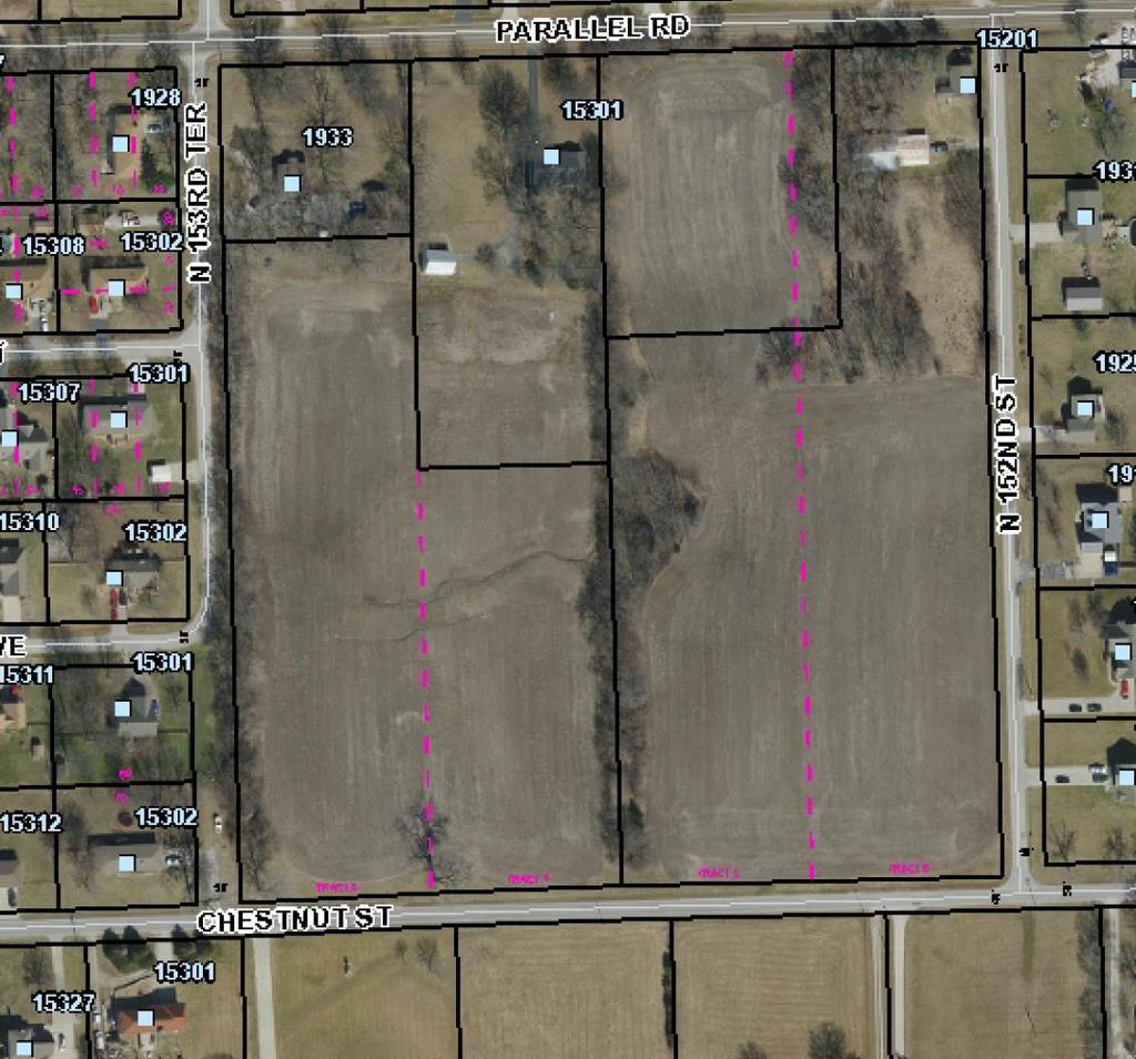
1 AGENDA BASEHOR PLANNING COMMISSION March 13, 7:00 p.m. Basehor City Hall 1. Call to Order 2. Pledge of Allegiance and Roll Call 3. Approval of Minutes of the preceding meeting. a. Minutes of the February 13, 2018 Planning Commission Meeting 4. Unfinished Business a. None New Business 5. Public Hearing: Request for rezoning approval for Lots 1 & 11; Block 5 of Honey Creek Farms- The applicant is requesting a rezoning from CP-2 General Business to R-1 Single Family of the two above mentioned lots. 6. Public Hearing: Request for approval of a Short Form Final Plat- request for approval of the proposed plat dividing Lots 1 & 11 of Block 5 into four (4) distinct lots for the purpose of constructing single family dwellings upon. 7. Consider a Final Plat for Tomahawk Valley, Phase 2- applicant is requesting approval of the 2 nd phase of Tomahawk Valley. The second phase of development consists of 28 lots and will border the northern portion of the new Garden Parkway roadway extension. This phase is located within the approved Final Development Plan. 8. Consider a Final Plat for the Mayfield subdivision- applicant is requesting approval of the first phase of their intended project, this first phase consists of 3 lots located within the approved Preliminary Plat and are on the northeast corner of the property (156 th Street and Leavenworth Road) 9. Consider a Final Plat for the Chestnut Estates subdivision- applicant is requesting approval of the Final Plat of Lots 1-9 of the Chestnut Estates, this plat is located within the previously approved Preliminary Plat. Generally located between Chestnut Street and Parallel Road and between N. 153 rd Street and N. 152 nd Street. 10. Open Agenda a. None 11. Reports from Special Committees a. None 12. Planning Directors Report 13. Adjournment
2
3 MINUTES BASEHOR PLANNING COMMISSION FEBRUARY 13, 2018 BASEHOR CITY HALL 1. Call to Order Chairman Commissioner Gallion called the meeting to order at 7:00 p.m. Pledge of Allegiance 2. Roll Call Members Present: Commissioners Dennis Haag, Mike Fonkert, Cecil Swenson, James Packard, Ben Sims and Chair Jon Gallion Staff Present: Mark Lee, Planning and Zoning Director; Connie Leggett, Planning Commission Secretary; Shannon Marcano, City Attorney; Lloyd Martley, City Administrator / Chief of Police Absent Members: Commissioner Terry Gallion 3. Approval of Minutes Commissioner Gallion called for a motion to approve the December 12, 2017 minutes. A motion was made by Commissioner Haag to approve the minutes with Commissioner Sims seconding. Commissioner Gallion called for a vote, Motion passed Unfinished Business None 5. Consider a Final Plat for the Boulders at Falcon Lakes Villas- Request for approval of the 1 st plat, consisting of sixty-one (61) lots. Mark Lee explained the property location, history of the property, requirements for this project, staff recommendations and how they might pertain to what is being requested for the approval of the 1 st Plat for the Boulders at Falcon Lakes Villas and that staff recommends approval of the request with certain recommendations that shall be met. Chair Gallion called for a motion on the request. Commissioner Haag made a motion to approve the final plat for the Boulders at Falcon Lakes Villas with the following stipulations set forth by staff as presented by staff; Commissioner Fonkert seconded. Chair Gallion called for a vote and the motion passed Public Hearing: Consider a Preliminary Plat for 3036 N. 156 th Street, Mayfield Subdivision, a 2.5 acre tract located on the southwest corner of Leavenworth Road and 156 th Street, legally describe as: Beginning at a point 22.5 feet South and feet East of the Northwest corner of the Northeast ¼ of the Northeast ¼ of Section 34, Township 10 South, Range 22 East, Leavenworth County, Kansas, thence feet, thence South feet, thence West feet, thence North feet, thence East feet, thence North feet to the point of beginning, except that part in streets and road.
4 Mark Lee explained the property location, history of the property, requirements for this project, staff recommendations and how they might pertain to what is being requested for the approval of the Preliminary Plat and that staff recommends approval of the request with certain recommendations that shall be met. Staff also explained that there was a typo on page 3; it is to be stated as South and not north. Commissioner Gallion called for a motion to open the Public Hearing. A motion made by Commissioner Swenson to open the public hearing with Fonkert seconding. Voting members approving in favor of the motion, the majority vote rules and the motion passed 6-0 at 7:06 p.m. Greg Ernzen, 5329 Park Street, Shawnee KS: Since the denial of the original request made at the last City Council meeting he has made changes to the plans which now reflect a single family dwelling, six (6) duplex layout, added additional parking and everything is all in regulation within the City of Basehor guidelines. Dennis Mertz, 9401 W. 89 th Street, Overland Park KS: Expressed his concerns for this project and ensuring that the regulations that are set forth by the city are met by this builder since we enforce the regulations on all builders that build within the city limits. Joe Herring, th Street, Leavenworth KS: Requested that Mark pull up the Falcon Lakes subdivision that was just approved for the verification of the right-away distance for clarification on the standards to ensure that this proposed project meets the same standards. Raymond Lynch, 2950 N. 156 th Street, Basehor KS: Expressed his concerns for the utility easement and the depth of the easement between the property and his property; about the short distance between his property; the water runoff and the collection of water that will be in between the properties and the potential water damage; the amount of traffic with the neighborhood kids going to and from school and playing outside. Jesse Brown, Leavenworth Road, Basehor KS: Expressed his concerns about the parking area connecting to his fence line on his property. Commissioner Gallion called for a motion to close the Public Hearing. A motion made by Commissioner Haag to close the public hearing with Commissioner Sims seconding. Voting members approving in favor of the motion, the majority vote rules and the motion passed 6-0 at 7:25 p.m. Chair Gallion called for a motion on the request for a Preliminary Plat. Commissioner Sims made a motion to approve the Preliminary Plat for 3036 N. 156 th Street with the following stipulations set forth by staff as presented by staff; Commissioner Haag seconded. Chair Gallion called for a vote and the motion passed Public Hearing: Consider a Short Form Plat of Z Ranch Estates, a acre tract legally describe as: PT SE1/4 BEG 30'W & 208.7'S OF NE COR, S860'(S), W1724.3', NELY ALONG RR 1100'(S), E520'(S), S208.7', E846.8' TO POB ABAN RR ROW ADJ Mark Lee explained the property location, history of the property, requirements for this project, staff recommendations and how they might pertain to what is being requested for the approval of the Short Form Plat. Staff recommends approval of the request with certain recommendations that shall be met.
5 Commissioner Gallion called for a motion to open the Public Hearing. A motion made by Commissioner Haag to open the public hearing for the short-form plat for the Z Ranch with Fonkert seconding. Voting members approving in favor of the motion, the majority vote rules and the motion passed 6-0 at 7:39 p.m. Joe Herring, th Street, Leavenworth KS: Explained the property and the intentions for the splitting of the lot. Commissioner Haag asked if this home on lot 2, the smaller lot, how it handles the sewer and will be get hooked up to the sewer system. Joe Herring replied that it is currently septic but will have to be updated and connected to the sanitary sewer line if the septic tank fails and when sewer is extended to the location. Commissioner Sims wanted to know the reason for the design of the small lot. Joe Herring replied that the property has a single car garage and wanted to keep the septic and lateral field within its boundaries. Justin Jacobs, 1516 N. 142 nd Street, Basehor: What the requirements would be for the main lot for the road frontage and for future developments in that area. Mark Lee replied that they would have to meet the requirements and all future plans would have to come before the board for approval. Randy Jacobs: Asked if there is way a road could be placed in between the properties and if it would be wide enough to place a road. Mark Lee replied with a yes, it would be wide enough for a road. Bob Fratzel, 1300 N. 142 nd Street, Basehor: Just wanted to state that he would be okay with the proposed plan but wanted to state also that he doesn t think that area will get developed any time soon. Commissioner Gallion called for a motion to close the Public Hearing. A motion was made by Commissioner Haag to close the public hearing with Sims seconding. Voting members approving in favor of the motion, the majority vote rules and the motion passed 6-0 at 7:49 p.m. Chair Gallion called for a motion on the request for a Preliminary Plat. Commissioner Fonkert made a motion to approve the Short Form Plat of Z Ranch Estates with the following stipulations set forth by staff as presented by staff; Commissioner Swenson seconded. Chair Gallion called for a vote and the motion passed Public Hearing: Consider a Preliminary Plat of the Chestnut Estates, a acre tract with a general location of, south of Parallel Road, north of Chestnut Street, east of North 153 rd Terrace and west of North 152 nd Street; legally described as: Commencing at the Northwest Corner of said Tract 3, South Basehor; thence S01 43'32"E along the West line of said Tract 3, a distance of feet ( feet Deed) to a found Car Axle, said point also being the Point of Beginning; thence N88 07'16"E, a distance of feet to a found 1 Rebar on the East line of said Tract 3; thence S01 41'46"E along the East line of said Tract 3, a distance of feet to a 1/2" Rebar with damaged cap as referenced per Lot Split Survey by prepared by Herring Surveying Company as Job # K , recorded April 9, 2015 as Document No.
6 2015S019, thence N88 18'14"E, a distance of feet to a 1/2 Rebar and Cap Herring LS 1296, said point being on the East line of said Tract 4; thence S01 40'49"E along the East line of said Tract 4, a distance of feet ( feet Deed) to a 1/2" Rebar with Metal Cover; thence S88 01'03"W along the South lines of said Tract 4 and Tract 3, a distance of feet to the Southwest Corner of said Tract 3; thence N01 43'32"W along the West line of said Tract 3, a distance of feet ( feet Deed) to the Point of Beginning, containing 273, square feet, more or less, subject to that part thereof in streets or public right-of-ways. Mark Lee excused himself from this discussion on the basis that would be a conflict of interest. Shannon Marcano, the City Attorney explained the property location, history of the property, requirements for this project, staff recommendations and how they might pertain to what is being requested for the approval of the Preliminary Plat. Staff recommends approval of the request with certain recommendations that shall be met. Matt Henderson, MHS, College Blvd, Lenexa: Explained the property, the sanitary sewer system to the property and to answer any questions. Commissioner Gallion called for a motion to open the Public Hearing. A motion made by Commissioner Fonkert to open the public hearing with Swenson seconding. Voting members approving in favor of the motion, the majority vote rules and the motion passed 6-0 at 7:58 p.m. George Moore, Chestnut, Basehor: Wanted to know if there is going to be street access to these properties, expressed his concerns about the water runoff that will take place; and the traffic that will be taking place on a street that is already to narrow. Joyce Mohan, Cedar Street, Basehor: Expressed her concerns with the water retention pond and it being very wet in that area; Expressed her concerns of what the plans were with the tree line that have been there for years; concerns over the street and the need for improvements and drainage. Brandi Stanley, Parallel Road, Basehor: Expressed her concerns with the green space and the amount of moisture that is in the ground there. Virginia Nunance, Versailles, Missouri; Expressed her concerns for her daughter s property, Parallel Road and the green space, moisture in the land and tree line. Patricia Wilson, 1933 N. 153 rd Terrace, Basehor; Expressed her concerns because part of her garages is on the property line and the bug problem within the area. Shannon Marcano replied to her concerns about the garage and the property line stating that she would need to contact the city staff for further information. Dennis Mertz, 9401 W. 89 th Street, Overland Park; Wanted to know if the owner of the property was correct on the deed and wanted clarification on who now owns the property. Shannon Marcano responded to these questions with the deed is not reviewed before they accept an application and that they will work through that process as they proceed; Mark Lee is the property owner and that is why he is not participating and has excused himself from this process.
7 Commissioner Gallion called for a motion to close the Public Hearing. A motion made by Commissioner Fonkert to close the public hearing with Swenson seconding. Voting members approving in favor of the motion, the majority vote rules and the motion passed 6-0 at 7:58 p.m. Commissioner Fonkert asked a question pertaining to the entrance point for these lots and to address the concerns of traffic. Matt Henderson, MHS, College Blvd, Lenexa; Replied that decision would be up to the builder but lots 6-9 would have access to Chestnut, lots 1-4 would have access to 153 rd Street and lot 5 would have access to Landauer. Chair Gallion called for a motion on the request for a Preliminary Plat. Commissioner Sims made a motion to approve the Preliminary Plat for the Chestnut Estates with the recommendations 1-10 set forth by staff as presented by staff; Commissioner Fonkert seconded. Chair Gallion called for a vote and the motion passed Open Agenda None at this time 10. Reports from Special Committees None at this time 11. Planning Directors Report a. Planning and Council will meet quarterly starting in June possibly the last Wednesday of the month and that the Planning Commission is welcomed to attend the Council Retreat. b. Receiving more multifamily permits and single family permits, Falcon Lakes has turned in 4-5 permits 12. Adjournment - Chair Gallion called for a motion to adjourn and Commissioner Haag made the motion with Fonkert seconding. Chair Gallion called for a vote and the motion passed 6-0. There being no further discussion, the meeting was adjourned at 8:34 p.m. Submitted for approval without additions or corrections this 13 th day of March, Chair Jon Gallion Connie Leggett, Planning Commission Secretary
8 City of Basehor Agenda Item Cover Sheet Agenda Item No. 5 Topic: Public Hearing- Request for rezoning approval for Lots 1 & 11; Block 5 of the Honey Creek Farms development. Action Requested: Applicant is requesting approval to rezone the 2 above mentioned lots from CP-2 (General Business) to R-1 (Single Family Residential). Narrative: The applicant is requesting a change of zoning to allow for the potential division of the lots and the possibility of constructing single family dwellings upon them. Presented by: Mark Lee-Planning & Zoning Director Staff Recommendation: Staff recommends approval of the rezoning with the recommendations stated in staff s report. Committee Recommendation: N/A Attachments: Staff Report (4pgs) Projector needed for this item? Yes
9
10 REQUEST FOR APPROVAL OF A ZONING CHANGE FROM CP-2 (GENERAL BUSINESS DISTRICT) TO R-1 (SINGLE FAMILY DISTRICT ZONING) FOR HONEY CREEK FARMS, LOTS 1 AND 11; BLOCK 5. MEETING DATE: March 13, 2018 REPORT WRITTEN: February 27, 2018 APPLICANT: Reliance Properties, LLC West 83 rd Street Shawnee KS OWNER: Same as Above REQUEST: The applicant is requesting approval to rezone, Lots 1 and 11 of Block 5 of the Honey Creek Farms subdivision. The request is to rezone from the current commercial zoning district of CP-2 (General Business) to R-1 (Single Family Residential). The applicant is requesting the change in zoning so they may move forward with the replatting of these two commercial lots into four individual lots to be used for the construction of single family dwellings. COMPREHENSIVE PLAN/FUTURE LAND USE MAP: The current Future Land Use Map designates this property as PR- Planned Residential District. SURROUNDING ZONING: North CP-2; General Business District (Undeveloped Honey Creek Farms) South R-0; Suburban Residential District (Single Family Large acreage tract) East R-0; Suburban Residential District (Undeveloped, zoned property) West PR; Planned Residential (Honey Creek Farms subdivision) BACKGROUND: The existing area has been vacant since development in 2004, it is currently platted and was done so in 2004 as well. The two lots are currently zoned commercial and occupy the southwest entrance to Honey Creek Farms at the intersection of 166 th Street and Pinehurst Drive. The applicant wishes to rezone and re-divide these two lots into four lots for the purpose of constructing single family residences. The purpose of the R-1 Zoning District is to provide for low density single family residential development, including those which reinforce residential neighborhoods. 1

11 THE CURRENT ZONING CONFIGURATION: 2
12 REZONING: According to Article 18, Section 8 of the Basehor Zoning Ordinance and the Golden case, the factors to be used in determining approval or denial of an application for rezoning are as follows: CHARACTER OF THE IMMEDIATE AREA The immediate area consists of a variety of residential uses from single family dwellings to large acreage tracts with single family dwellings constructed upon them as well as undeveloped agricultural land. THE ZONING AND USES OF THE PROPERTY NEARBY The properties immediately surrounding these lots are zoned, PR; Planned Residential, as well as CP-2; General Business. THE SUITABILITY OF THE SUBJECT PROPERTY FOR THE USES TO WHICH IT HAS BEEN RESTRICTED The property is currently zoned commercial and with its close proximity to existing residential structures, the suitability of the property to remain as currently zoned may not be the best use in staff s opinion. The proposed area is currently vacant, although the area was platted in 2004, no construction has taken place to this date, other than minor utility infrastructure around the perimeters of the properties. While the proposed properties will add more driveway approaches (3) to a frontage road (Pinehurst Drive) and (1) the arterial roadway of 166 th Street, staff feels as though the amount of traffic generated at the additional access points will be far less demanding than if the properties were to develop commercially. THE EXTENT TO WHICH REMOVAL OF THE PRESENT ZONING WILL DETRIMENTALLY AFFECT NEARBY PROPERTY Rezoning the property to R-1, Single Family Residential District will maintain the residential character of the Honey Creek Farms neighborhood of which the property abuts, and will have a minimal impact on nearby property by blending in to the current housing structures located around the general area. THE LENGTH OF TIME THE PROPERTY HAS REMAINED VACANT AS ZONED The property was platted in 2004 and has remained vacant since that time. THE RELATIVE GAIN TO THE PUBLIC HEALTH, SAFETY, AND WELFARE BY THE DESTRUCTION OF THE VALUE OF THE PETITIONER S PROPERTY AS COMPARED TO THE HARDSHIP IMPOSED UPON THE INDIVIDUAL LANDOWNERS The applicant is requesting a rezoning from a commercial district to a residential district, denial of the request would not affect the value of the land, and would not impose a great hardship on the applicant as the property could be utilized for other uses allowed in the current zoning district. However, as the property has not developed commercially over the past fourteen years, rezoning the property to residential may allow for it to be developed at a much faster rate. There would be little gain to the public health, safety and welfare if the rezoning request were denied as the land would continue to be vacant. RECOMMENDATION OF PROFESSIONAL STAFF- Staff recommends approval of the request to rezone the property to R-1, Single Family Residential District. 3
13 THE CONFORMANCE OF THE REQUESTED REZONING TO THE DULY ADOPTED COMPREHENSIVE PLAN The Comprehensive Plan's future land use map identifies the subject property as PR-Planned Residential District. Rezoning the property to R-1 will maintain the residential character of the immediate area. The Comprehensive Plan states: Planned Residential District is intended to offer a mixture of residential opportunities in a single development. The purpose of this district is to provide for elements of flexibility in design, placement, arrangement, bulk, and other considerations; to interrelated and compatible with the residential character of these development areas and adjacent developments; and to maintain the desired overall intensity; efficiency in the provision of public facilities and services, and to provide protection for existing development while allowing new construction in accordance with current development and performance standards and density objectives. Dwelling units within the district should be developed with a variety of architectural styles and layouts.. STAFF RECOMMENDATION: Staff recommends approval of the rezoning of Lots 1 and 11; Block 5 of the Honey Creek Farms subdivision, from CP-2 (General Business District) to R-1 (Single Family Residential District) with the following stipulations: 1. The property owner shall be responsible for the completion of the plat process. 2. In addition to the stipulations listed in this report, the developer/property owner agrees to abide by all of the ordinances of the City of Basehor. 4
14 City of Basehor Agenda Item Cover Sheet Agenda Item No. 6 Topic: Public Hearing- Short Form Final Plat for Lots 1 & 11; Block 5 of the Honey Creek Farms development. Action Requested: Applicant is requesting approval to subdivide the above mentioned lots. Narrative: The applicant is requesting the approval of the proposed subdivision of Cornish Estates. This proposed subdivision will take the existing two lots and reconfigure them into 4 different lots. Three lots will front along Pinehurst Drive with the remaining lot fronting 166 th Street. The applicant is proposing the construction of four single family dwellings upon the lots. Presented by: Mark Lee-Planning & Zoning Director Staff Recommendation: Staff recommends approval of the Short Form Final Plat for Cornish Estates with the recommendations stated in staff s report. Committee Recommendation: N/A Attachments: Staff Report (3pgs) Aerial image (1pg) Review comments/including copy of plat (3pgs) Projector needed for this item? Yes
15
16 SHORT FORM PLAT OF CORNISH ESTATES REQUEST FOR APPROVAL VIA THE SHORT FORM PLAT PROCESS. A short form final plat of Cornish Estates, a replat of Lots 1 and 11; Block 5 of the Honey Creek Farms subdivision. MEETING DATE: March 13, 2018 REPORT WRITTEN: February 27, 2018 STAFF RECOMMENDATION: Staff recommends approval by the Planning Commission of the Cornish Estates with the stipulations stated in the staff report. APPLICANT: Applicant: Reliance Properties, LLC (Jason Cornish-Owner) West 83 rd Street Shawnee KS Surveyor: Atlas Surveyors, LLC 2300 Hutton Road Kansas City KS REQUEST: The applicant is requesting approval of a Short Form Plat. The approval of the short form final plat will divide two larger lots in the existing Honey Creek Farms subdivision into four (4) different lots. BACKGROUND: The two lots are currently platted as Lots 1 and 11 of Block 5, these properties are currently vacant and have been since the property was platted in A short-form plat procedure is being utilized for this application. The purpose for a short-form plat is to provide a means of approving a subdivision of land that contains four (4) lots or less. The short-form plat shall serve as the final plat of the subdivision. The submission and approval of a preliminary plat is not required as a prerequisite for a short-form plat approval; provided, that the public hearing requirements outlined in preliminary plats are met. SITE CHARACTERISTICS: The site is approximately two (2) acres in size located at the southwest corner of the intersection of Pinehurst Drive and 166 th Street. The property is currently vacant. 1
17 ZONING: The property is currently zoned CP-2, General Business District. SURROUNDING ZONING: North CP-2 General Business District (Commercial) South R-0 Suburban Residential East R-0 Suburban Residential West PR Planned Residential Traffic Impact Traffic impact should be of a lesser nature than if the two lots were to remain commercial, there will be a driveway that exits onto 166 th Street. This street, as indicated in our Comprehensive Plan is slated to be an Arterial Street in the future, but again, the impact should be less than if it was a commercial business utilizing the same access points. Stormwater Management For the division of these lots, the existing stormwater management systems will not be impacted nor new systems be needed. The retention pond in place currently was designed to capture the flow from the development as it stands, with the removal of commercial zoning from these lots, it should in fact reduce the amount of water retainage necessary. Utilities The majority if not all of the utility infrastructure is in place currently, the division of the lots may result in more connection points but no new installation should be needed. 2
18 Subdivision Regulations Requirements The items to be included on the final plat per the Subdivision Regulations requirements have been addressed by the city engineers review comments and forwarded on to the applicants surveyor. STAFF RECOMMENDATION: Staff recommends approval of short form final plat for Cornish Estates with the following stipulations: 1. Park Impact Fee-per city ordinance applicants for new buildings shall be required to pay a park impact fee (Parkland Fee) on all buildings at time of building permit issuance. This fee shall be $ per individual building. 2. Transportation Excise Tax- Per city regulations, commercial property shall pay the TET directly after to the platting of all commercial property, therefore the TET has been paid. 3. All comments from City Staff and the County Surveyor must be addressed prior to release of final plat for filing. 4. The final plat shall be recorded with the Leavenworth County Register of Deeds upon approval. 5. In addition to the stipulations listed in this report, the developer/property owner agrees to abide by all of the ordinances of the City of Basehor. 3


19 Legend Notes Address Point Parcel Subdivisions Lot Line Plat Block Number Parcel Lot Dimension City Limit Line Major Road Road <all other values> 70 Railroad Section Section Boundaries County Boundary Cornish Estates 1 in. = 115ft Feet This Cadastral Map is for informational purposes only. It does not purport to represent a property boundary survey of the parcels shown and shall not be used for conveyances or the establishment of property boundaries. THIS MAP IS NOT TO BE USED FOR NAVIGATION
20
21 10' U/E 10' U/E 10' U/E Esmt 15' W/L 10' U/E Esmt 15' W/L 10' U/E 30' BSL N01 47'08"W ' ' ' 10' U/E OWNER: KATHRYN L & DON J ROUSSELO PID ' BSL Lot 1 Contains 0.33 acres more or less VICINITY MAP NOT TO SCALE 166TH STREET STATE AVE (HIGHWAY 24/40) PROJECT LOCATION 92.00' 92.08' 92.00' N88 12'53"E ' PINEHURST DRIVE S88 12'53"W ' 15' BSL 20' U/E 15' BSL Original Lot Line 15' BSL Lot 2 Contains 0.35 acres more or less Original Lot 1, Block 5 Honeycreek Farms Lot 4 Contains 1.14 acres more or less OWNER: MARK JOHN BASKA PID ' BSL ' 20'x20' D/E 30' BSL 30' BSL ' S88 12'53"W ' 92.00' 92.08' 92.00' N01 47'08"W ' 166TH STREET Lot 3 Contains 0.33 acres more or less NOTES: 1. ALL DISTANCE SHOWN HEREON ARE IN FEET 2. BASIS OF BEARING: FINAL PLAT HONEY CREEK FARMS 3. FLOOD ZONE: THIS PROPERTY LIES WITHIN FLOOD ZONE X. ACCORDING TO FEMA FLOOD MAP NUMBER 20103C0326G, DATED JULY 16, 2015, DEFINED AS NO BASE ELEVATION DETERMINED. 4. FENCE LINES DO NOT NECESSARILY DENOTE PROPERTY LINES 5. EXISTING AND PROPOSED USES FOR ALL LOTS ARE RESIDENTIAL. RESTRICTIONS: 1) All proposed structures within this plat shall comply with the Leavenworth County Zoning and Subdivision Regulations or zoning regulation jurisdiction. 2) Building setbacks are as shown on the map ' 10' U/E Description: ALL OF LOTS 1 AND 11, BLOCK 5, HONEYCREEK FARMS, A SUBDIVISION OF LAND IN THE CITY OF BASEHOR, LEAVENWORTH COUNTY, KANSAS. CONTAINS: 2.14 ACRES MORE OR LESS 1"=30' 0 15' 30' LEGEND: DENOTES FOUND 1 2" BAR AS NOTED DENOTES SET 1 2" BAR LS 1408 FINAL PLAT CORNISH ESTATES AT HONEY CREEK FARMS APPROVALS We, the Leavenworth County Planning Commission, do hereby approve the foregoing plat of CORNISH ESTATES AT HONEY CREEK FARMS this day of, Secretary Chairman Sajiv Joseph Steven Rosenthal COUNTY ENGINEER'S APPROVAL: The County Engineer's plat review is only for general conformance with the subdivisio regulations as adopted by Leavenworth County. The County is not responsible for the accuracy and adequacy of the design, dimensions, elevations, and quantities. Engineer - Mitch Pleak, P.E. REGISTER OF DEED CERTIFICATE: Filed for Record as Document No. on this day of, 2018 at o'clock M in the Office of the Register of Deeds of Leavenworth County, Kansas, Register of Deeds - Stacy Driscoll I hereby certify that this plat meets the requirements of K.S.A The face of this plat was reviewed for compliance with Kansas Minimum Standards for Boundary Surveys. No field verification is implied. This review is for survey information only. Wayne Malnicof County Surveyor COMMISSION APPROVAL: We, the Board of Commissioners of the City of Basehor, Kansas, do hereby approve the foregoing plat CORNISH of ESTATES AT HONEY CREEK FARMS this day of, Chairman County Clerk DEDICATION : The undersigned proprietors of the above described tract of land state that all taxes have been paid and that they have caused the same to be subdivided in the manner as shown on the accompanying plat which hereafter shall be known as "CORNISH ESTATES AT HONEY CREEK FARMS." All streets, drives, terraces and other ways shown hereon and not heretofore dedicated to the public are hereby so dedicated. An easement is hereby granted all public utility companies, their successors or assign or rural water districts duly incorporated and authorized to do business in Leavenworth County, Kansas, to enter upon, over and under these areas outlined and designated on this plat as "Utility Easement" or "Drainage Easement" or "U/E" or "D/E" for purposes of utility installations and maintenance thereof. The use of said easement by any such entity shall obligate such entity to return said easement to its condition prior to any installation, maintenance or repair performed on said easement. IN TESTIMONY WHEREOF, I, the undersigned owner of, have set our hands this day of, Jason Cornish (MANAGING MEMBER OF RELIANCE PROPERTIES, LLC) NOTARY CERTIFICATE: Be it remembered that on this day of 2018, before me, a notary public in and for said County and State came Jason Cornish, to me personally known to be the same persons who executed the forgoing instrument of writing, and duly acknowledged the execution of same. In testimony whereof, I have hereunto set my hand and affixed my notary seal the day and year above written. NOTARY PUBLIC My Commission Expires: (seal) I hereby certify that this survey was made by me, or under my direct supervision, on the ground during the month of March 2016 and this map or plat is correct to the best of my knowledge. ROGER B DILL LS # 1408 OWNER: Reliance Properties LLC W 83rd Street Shawnee, Kansas FINAL PLAT CORNISH ESTATES AT HONEY CREEK SEC. 9, T11S, R22E BASEHOR, KANSAS DATE: January 24, 2018 ATLAS SURVEYORS,, LLC. TAKING CARE OF YOUR NEEDS 207 S. 5TH STREET LEAVENWORTH, Kansas
 PROJECT LOCATION 92.00' 92.08' 92.00' N88 12'53\"E 276.08' PINEHURST DRIVE S88 12'53\"W 276.")
22 10' U/E 10' U/E 10' U/E Esmt 15' W/L 10' U/E Esmt 15' W/L 10' U/E 30' BSL N01 47'08"W ' ' ' 10' U/E OWNER: KATHRYN L & DON J ROUSSELO PID ' BSL Lot 1 Contains 0.33 acres more or less VICINITY MAP NOT TO SCALE 166TH STREET STATE AVE (HIGHWAY 24/40) PROJECT LOCATION 92.00' 92.08' 92.00' N88 12'53"E ' PINEHURST DRIVE S88 12'53"W ' 15' BSL 20' U/E 15' BSL Original Lot Line 15' BSL Lot 2 Contains 0.35 acres more or less Original Lot 1, Block 5 Honeycreek Farms Lot 4 Contains 1.14 acres more or less OWNER: MARK JOHN BASKA PID ' BSL ' 20'x20' D/E 30' BSL 30' BSL ' S88 12'53"W ' 92.00' 92.08' 92.00' N01 47'08"W ' 166TH STREET Lot 3 Contains 0.33 acres more or less NOTES: 1. ALL DISTANCE SHOWN HEREON ARE IN FEET 2. BASIS OF BEARING: FINAL PLAT HONEY CREEK FARMS 3. FLOOD ZONE: THIS PROPERTY LIES WITHIN FLOOD ZONE X. ACCORDING TO FEMA FLOOD MAP NUMBER 20103C0326G, DATED JULY 16, 2015, DEFINED AS NO BASE ELEVATION DETERMINED. 4. FENCE LINES DO NOT NECESSARILY DENOTE PROPERTY LINES 5. EXISTING AND PROPOSED USES FOR ALL LOTS ARE RESIDENTIAL. RESTRICTIONS: 1) All proposed structures within this plat shall comply with the Leavenworth County Zoning and Subdivision Regulations or zoning regulation jurisdiction. 2) Building setbacks are as shown on the map ' 10' U/E Description: ALL OF LOTS 1 AND 11, BLOCK 5, HONEYCREEK FARMS, A SUBDIVISION OF LAND IN THE CITY OF BASEHOR, LEAVENWORTH COUNTY, KANSAS. CONTAINS: 2.14 ACRES MORE OR LESS 1"=30' 0 15' 30' LEGEND: DENOTES FOUND 1 2" BAR AS NOTED DENOTES SET 1 2" BAR LS 1408 FINAL PLAT CORNISH ESTATES AT HONEY CREEK FARMS APPROVALS We, the Leavenworth County Planning Commission, do hereby approve the foregoing plat of CORNISH ESTATES AT HONEY CREEK FARMS this day of, Secretary Chairman Sajiv Joseph Steven Rosenthal COUNTY ENGINEER'S APPROVAL: The County Engineer's plat review is only for general conformance with the subdivisio regulations as adopted by Leavenworth County. The County is not responsible for the accuracy and adequacy of the design, dimensions, elevations, and quantities. Engineer - Mitch Pleak, P.E. REGISTER OF DEED CERTIFICATE: Filed for Record as Document No. on this day of, 2018 at o'clock M in the Office of the Register of Deeds of Leavenworth County, Kansas, Register of Deeds - Stacy Driscoll I hereby certify that this plat meets the requirements of K.S.A The face of this plat was reviewed for compliance with Kansas Minimum Standards for Boundary Surveys. No field verification is implied. This review is for survey information only. Wayne Malnicof County Surveyor COMMISSION APPROVAL: We, the Board of Commissioners of the City of Basehor, Kansas, do hereby approve the foregoing plat CORNISH of ESTATES AT HONEY CREEK FARMS this day of, Chairman County Clerk DEDICATION : The undersigned proprietors of the above described tract of land state that all taxes have been paid and that they have caused the same to be subdivided in the manner as shown on the accompanying plat which hereafter shall be known as "CORNISH ESTATES AT HONEY CREEK FARMS." All streets, drives, terraces and other ways shown hereon and not heretofore dedicated to the public are hereby so dedicated. An easement is hereby granted all public utility companies, their successors or assign or rural water districts duly incorporated and authorized to do business in Leavenworth County, Kansas, to enter upon, over and under these areas outlined and designated on this plat as "Utility Easement" or "Drainage Easement" or "U/E" or "D/E" for purposes of utility installations and maintenance thereof. The use of said easement by any such entity shall obligate such entity to return said easement to its condition prior to any installation, maintenance or repair performed on said easement. IN TESTIMONY WHEREOF, I, the undersigned owner of, have set our hands this day of, Jason Cornish (MANAGING MEMBER OF RELIANCE PROPERTIES, LLC) NOTARY CERTIFICATE: Be it remembered that on this day of 2018, before me, a notary public in and for said County and State came Jason Cornish, to me personally known to be the same persons who executed the forgoing instrument of writing, and duly acknowledged the execution of same. In testimony whereof, I have hereunto set my hand and affixed my notary seal the day and year above written. NOTARY PUBLIC My Commission Expires: (seal) I hereby certify that this survey was made by me, or under my direct supervision, on the ground during the month of March 2016 and this map or plat is correct to the best of my knowledge. ROGER B DILL LS # 1408 OWNER: Reliance Properties LLC W 83rd Street Shawnee, Kansas FINAL PLAT CORNISH ESTATES AT HONEY CREEK SEC. 9, T11S, R22E BASEHOR, KANSAS DATE: January 24, 2018 ATLAS SURVEYORS,, LLC. TAKING CARE OF YOUR NEEDS 207 S. 5TH STREET LEAVENWORTH, Kansas
23 City of Basehor Agenda Item Cover Sheet Agenda Item No. 7 Topic: Final Plat for Tomahawk Valley Phase 2- Request for approval of the final plat for the Tomahawk Valley Phase 2. Action Requested: Applicant is requesting approval of a final plat as presented. Narrative: This final plat of Phase 2 consists of 28 lots. The development is located within the previously approved Final Development Plan of Tomahawk Valley. Phase 2 is bordered by Phase 1 to the north and the proposed Garden Parkway extension to the south. Presented by: Mark Lee-Planning & Zoning Director Staff Recommendation: Staff recommends approval of the final plat for Tomahawk Valley Phase 2 with the recommendations stated in staff s report. Committee Recommendation: N/A Attachments: Staff Report (4pgs) Copy of plat (1pg) Projector needed for this item? Yes
24
25 FINAL PLAT OF TOMAHAWK VALLEY PHASE 2- REQUEST FOR APPROVAL OF THE FINAL PLAT A Final Plat of Lots 1-28, of the 2nd plat of Tomahawk Valley. MEETING DATE: March 13, 2018 REPORT WRITTEN: March 1, 2018 STAFF RECOMMENDATION: Staff recommends that the Planning Commission approve the Final Plat for the Tomahawk Valley Phase 2, with the stipulations stated in the staff report. APPLICANT: Miles Excavating Inc. PO Box 458 Basehor KS ENGINEERS/SURVEYOR: Schlagel & Associates, P.A West 107 th Street Lenexa, KS REQUEST: The applicant is requesting approval of a final plat for the second phase of Tomahawk Valley within the previously approved Final Development Plan located between 155 th Street and 158 th Street, south of Landauer Street and north of Wolf Creek Parkway. ZONING: The property is currently zoned PR Planned Residential District. SURROUNDING ZONING: North: P-R Planned Residential (existing 1 st plat of Tomahawk Valley) South: CP-2 Vacant Land East: R-O Large-lot Residential West: PR Planned Residential (Tomahawk Valley future phase) BACKGROUND: Tomahawk Valley has gone through many stages over the past few years but most recently the Planning Commission and City Council approved both a Preliminary Development Plan and a Final Development Plan, which gave Miles Excavating the authority to move forward on the previously platted Phase 1. Since the passage of the Final Development Plan in March 2017 construction has been completed on the 1 st Phase and lots are ready to be sold to the public. The city has also committed to funding a road extension project to construct Garden Parkway from 155 th Street west to 158 th Street, this newly proposed phase will directly abut and access this new roadway. A Final Plat for each of the remaining phases of the development (Phases 3, 4, 5 and 6) must be approved by the City and filed with the Leavenworth County Register of Deeds before construction on any of those phases can proceed. 1

26 The typical final plat procedures are being utilized for this application. The purpose of a final plat is to provide a means of approving a subdivision of land to insure compliance with the Zoning and Subdivision Regulations as well as the Manual for Public and Private Improvements of the City of Basehor. It establishes the overall layout and design of the proposed subdivision. Any deviation of the final plat from the intent of the approved Final Development Plan as determined by the Planning Commission shall cause the re-initiation of the Development Plan process as described in Article 7; Section 5; Planned Residential District of the Zoning Regulations of the City of Basehor. Traffic Impact Two entrance/exit points to this phase of the subdivision are proposed one being through Phase 1 from 156 th Street eventually exiting to 155 th Street and the other being at Garden Parkway which will feed to both 155 th Street and 158 th Street. It is anticipated there will be an additional 268 more Average Daily Trips from this new phase, with 28 PM Peak Trips. 2
27 Stormwater Management Drainage from this development will enter the Hog Creek drainage system. The drainage report indicates that post-development stormwater discharge from the site will be below allowable release rates per the City of Basehor specifications. Phase 2 will not require onsite detention and onsite detention will be constructed for future phases. The applicant has a current Notice of Intent (NOI) for stormwater runoff from construction activities from the Kansas Department of Health and Environment (KDHE). Utilities New utilities are proposed with the subject plat. As part of the final plat, sanitary sewer easements as well as other utility easements are being put in place. All review comments from the utility companies have been addressed. Subdivision Regulations Requirements The items to be submitted with and included on the final plat per the Subdivision Regulations requirements and any appropriate comments from the applicant shall be addressed prior to plat release for recording. STAFF RECOMMENDATION: Staff recommends approval of the Final Plat of the Tomahawk Valley, Second Plat application as being in substantial compliance with the approved Final Development Plan with the following stipulations: 1. The applicant shall be responsible for a. Park Impact Fee- per city ordinance the applicant shall be required to pay a park impact fee (Parkland Fee) on individual dwelling units at the time of building permit issuance. This fee shall be $ for each individual unit ($400) per duplex lot. b. Transportation Improvement Impact Fee- shall be paid at time of building permit issuance. The excise tax is as follows: ac. = 493, sft. 493, *.09= $44, ,409.90/28 lots= $1, per lot The excise tax has been calculated as set forth by Ordinance Street Trees and landscaping shall be planted/installed by the developer as defined by the submitted and approved landscape plan in all areas shown below and shall be planted/installed during the individual phases in which they are indicated: a. Areas designated as green space/open space (approximate number of trees 19) b. All other required street trees shall be installed prior to Occupancy Certificates being issued for individual dwelling units and duplexes, and shall be the responsibility of the individual builder(s). c. All street trees shall be planted on average of every fifty (50 ) feet. No individual lot shall contain less than two (2) required street trees. (approximate number 258) 3
28 3. All review comments made by the County Surveyor, City Staff and the City Engineer shall be addressed prior to releasing the plat for signatures and filing. 4. In addition to the stipulations in this report, the developer/property owner agrees to abide by all regulations contained in the Basehor Zoning Ordinances and Subdivision Regulations. 5. All construction drawings pertinent to the approved final plat (sewer, stormwater) and construction of public improvements shall be submitted and approved prior to building permits being issued. 6. A subdivision Improvement Agreement shall be prepared and approved by City Council coinciding with the approval of the final plat and shall be recorded with the Leavenworth County Register of Deeds by the owner/developer. 7. The final plat shall be recorded with the Register of Deeds of Leavenworth County, one registered copy shall be returned to city staff for record keeping purposes, prior to a building permit being issued. 4
29 50' R/W 60.00' N01 47'29"W N01 47'29"W ' S01 45'41"E ' 158TH STREET NW1/4 NE1/4 150TH STREET 155TH ST 2 SW1/4 SE1/4 WOLF CREEK PKWY 27.28' S01 47'29"E ' 30' BL 95.99' 15' U/E ' 30' ' 30' BL 46.98' 30' ' 30' CL 155TH ST 155TH STREET BLOCK THREE UNPLATTED N36 57'48"E 77.79' BLOCK FIVE S63 55'29"E 50.83' 10' U/E S74 17'47"E ' ' TOMAHAWK VALLEY S69 49'25"E ' 25.41' ' 25' 67.56' ' TH LANE N15 42'15"E ' N15 42'14"E ' 5 1 S60 02'52"E ' S27 20'34"W ' S27 20'34"W ' R=14.00' L=19.15' 68.07' 36.90' 72.50' S74 17'46"E ' 30' BL 13.00' 30' BL 74.44' 29.37' 30' BL 15' U/E 38.64' S74 17'46"E ' R50' 67.07' 70.03' N13 43'50"W 97.64' BLOCK SIX SHERIDAN CT N62 39'26"W ' 25' R= ' ' 25' L=321.40' Δ=17 52'44" ITB=N88 12'31"E 25' TRACT "A" FOUND 1/2" REBAR W/ PLS 610 CAP IN CONCRETE 30' 30' R= ' L=508.49' Δ =29 08'03" N62 39'26"W ' N27 20'34"E ' ' R50' LOT 1 FIRST BAPTIST CHURCH 60.00' 30' 25' N40 21'42"W ' 25' 25' 156TH TERR R=970.00' L=493.23' Δ =29 08'03" ITB=N62 39'26" W N62 39'26"W ' 30' ' ' N62 39'26"W ' N27 20'34"E 30.00' N62 39'26"W 60.00' S27 20'34"W 30.00' S62 39'26"E 50.00' ' S27 20'34"W ' ' S27 20'34"W ' 65.00' 67.49' 39.06' 35.40' N59 05'00"E ' 30' BL 68.00' ' 67.00' 65.00' 92.29' 70.00' S62 39'26"E ' ' 87.54' S27 20'34"W ' 65.00' S83 57'22"E ' S27 20'34"W ' 92.29' 70.00' 70.00' 95.00' N27 20'34"E ' N29 15'54"E ' N14 19'36"E ' 6.30' R=38.00' L=29.37' CL 15' U/E 15' U/E 30' BL 30' BL 15' U/E CL 15' P/E & U/E 15' U/E 30' BL S27 20'34"W ' 70.00' 44.71' 27.14' N27 20'34"E ' ' 48.67' N27 20'34"E ' 47.40' 70.83' 30' BL 15' U/E 15' U/E 30' BL 30' BL S39 51'28"W ' S27 20'34"W ' 12.73' CL 15' U/E 15' U/E& L/E 65.07' 95.00' ' 52.27' 4.08' 65.00' 65.93' ' 38.28' 37.18' R=60.00' 65.00' S73 15'05"W ' 36.16' 65.00' N27 20'34"E ' 95.00' 30' BL 30' BL 15' U/E 15' U/E 15' U/E& L/E 15' U/E 30' BL 15' U/E 38.92' R=60.00' N27 20'34"E ' 38.30' 41.26' ' 3.22' N27 20'34"E ' 15' U/E& L/E 95.00' N62 09'01"W ' ' N27 20'34"E ' 65.00' 30' BL LOT 1 LVCRWD NO 1 ELEVATED TANK PLAT 60' A/E B 531, P 1385 UNPLATTED R/W 155TH ST RECORDED IN BK. B, PG. 296 N62 39'26"W ' FOUND 5/8" REBAR N18 16'02"W ' N27 20'34"E ' 65.00' 65.00' 47.72' 15' U/E& L/E 27.30' N87 58'32"E ' FOUND BENT 1/2" REBAR W/ PLS 610 CAP ' UNPLATTED GARDEN PARKWAY 65.86' R=470.00' R=500.00' S01 45'41"E 60.00' S87 58'32"W ' 30' L=256.28' Δ=29 22'02" R/W 31.02' 30' S87 58'32"W ' R=530.00' L=238.68' FOUND 5/8" REBAR Δ=25 48'09" ITB=N88 27'35"W SECTION 2-T11-R22 LOCATION MAP SCALE 1" = 2000' NW. CORNER SW. 1/4 SEC. 2-T11 S-R22 E 5/8 " REBAR UNPLATTED 158TH STREET N88 12'31"E ' 30' GARDEN PARKWAY S88 12'31"W ' 30' S88 12'31"W ' UNPLATTED W. LINE SW. 1/4, SEC. 2-T11-R 22 SW. CORNER SW. 1/4 SEC. 2-T11 S-R22 E 2" ALUMINUM DISK LEGEND: BL - BUILDING LINE R/W - RIGHT-OF-WAY EXISTING LOT AND PROPERTY LINES EXISTING PLAT AND R/W LINES D/E - DRAINAGE EASEMENT U/E - UTILITY EASEMENT PLAT CORNERS (CONTROLLING CORNERS OF SUBDIVISION) SurveyPropertyCornerSymbols SurveyPropertyCornerSymbols SurveyPropertyCornerSymbols FOUND SET 1/2" REBAR, 3 FEET LONG IN CONCRETE W/LS-54 CAP EXISTING FOUND BAR AS NOTED SET IN CONCRETE BASE MONUMENT AS NOTED NOTES: CONCRETE SET AROUND FOUND BARS SHOWN THAT WERE NOT IN CONCRETE. AFTER CONSTRUCTION OF PUBLIC IMPROVEMENTS. CURB CUTS ARE TO BE SET AT THE PROLONGED EXTENSION OF THE LOT LINES ALONG STREETS. 1/2" REBAR, A MINIMUM OF 2 FEET LONG ARE TO BE SET AT HORIZONTAL CURVE CONTROL POINTS IN STREETS AND ALL LOT CORNERS (FRONT AND REAR, EXCEPT THOSE ALREADY SET AS PLAT CORNERS). DEDICATION: The undersigned proprietors of the above described tract of land has caused the same to be subdivided in the manner shown on the accompanying plat which hereafter shall be known as "TOMAHAWK VALLEY, SECOND PLAT". The streets and roads shown on this plat and not heretofore dedicated as thoroughfares are hereby dedicated to the City of Basehor, Leavenworth County, Kansas. An easement or license to enter upon, locate, construct and maintain or authorize the location, construction or maintenance and use of conduits, pipes, inlets, manholes, surface drainage facilities and other similar facilities, upon, over and under those areas outlined and designated on this plat as "Drainage Easement" or "D/E", is hereby granted to the City of Basehor, Leavenworth County, Kansas, or its designees. A perpetual easement for pedestrian access over, under, across and upon the areas designated as "Pedestrian Access Easement" or "P/E" is hereby reserved by the undersigned proprietor, its heirs, assigns, or successors for ingress and egress of all owners and occupants of lots and parcels depicted on this plat, their guests and invitees. No obstructions that would prohibit the free flow of pedestrian traffic shall be allowed to be constructed or maintained within said easement. All owners of lots within this plat, or their respective successors in interest, shall be equally responsible for the maintenance, repair, and/or replacement of the bike/hike trail and other amenities contained within said easement and shall share equally in the costs of such maintenance, repair, and/or replacement. T An easement or license to enter upon, locate, construct and maintain or authorize the location, construction or maintenance and use of conduits, pipes, poles, wires, drainage facilities, ducts and cables, sewers, manholes, and similar facilities, upon, over and under those areas outlined and designated on this plat as "Utility Easement" or "U/E" is hereby granted to the City of Basehor, Leavenworth County, Kansas, or its designees. N 0 60' 120' NAD83 - KANSAS NORTH ZONE: WEST LINE OF SOUTHWEST 1/4, SEC BEARING N 01 47'29" W BENCH MARK USGS DATUM: Leavenworth County Control Network Bench Mark: LVCO-311. NAVD88 Elevation = SURVEYOR'S NOTES: 1. A this property lies within flood ZONE X, defined as areas determined to be outside the 0.2% annual chance floodplain, as shown on the Flood Insurance Rate Map 20103C0327G, Revised July 16, The Error of Closure noted for the Plat is 1 : DESCRIPTION: Part of the Southwest One-Quarter of Section 2, Township 11 South, Range 22 East, in the City of Basehor, Leavenworth County, Kansas, more particularly described as follows: Commencing at the Southwest corner of the Southwest One-Quarter of said Section 2; thence North 01 degrees 47 minutes 29 seconds West along the West line of said Southwest One-Quarter, a distance of feet to the Point of Beginning; thence continuing North 01 degrees 47 minutes 29 seconds West along the West line of said Southwest One-Quarter, a distance of feet; thence North 88 degrees 12 minutes 31 seconds East a distance of feet to a point of curvature; thence Southeasterly on a curve to the right tangent to the previous course having a radius of feet, a central angle of 17 degrees 52 minutes 44 seconds ad an arc length of feet; thence North 40 degrees 21 minutes 42 seconds West a distance of feet; thence North 13 degrees 43 minutes 50 seconds West a distance of feet; thence North 15 degrees 42 minutes 14 seconds East a distance of feet; thence North 36 degrees 57 minutes 48 seconds East a distance of feet to a point on the South line of TOMAHAWK VALLEY, a subdivision in the City of Basehor, recorded as document No. 2010P00012, Leavenworth County register of deeds, said point being the Southwest corner of Lot 7, Block Three; thence along the South line of said TOMAHAWK VALLEY the following seven courses South 74 degrees 17 minutes 47 seconds East (platted North 72 degrees 51 minutes 52 seconds West) a distance of feet; thence South 63 degrees 55 minutes 29 seconds East (platted North 62 degrees 29 minutes 34 seconds West) a distance of feet; thence South 69 degrees 49 minutes 25 seconds East (platted North 68 degrees 23 minutes 30 seconds West) a distance of feet; thence South 60 degrees 02 minutes 52 seconds East (platted 58 degrees 36 minutes 57 seconds West) a distance of feet; thence South 62 degrees 39 minutes 26 seconds East (platted North 61 degrees 13 minutes 3 seconds West) a distance of feet; thence South 62 degrees 39 minutes 26 seconds East (platted North 61 degrees 13 minutes 3 seconds West) a distance of feet; thence South 83 degrees 57 minutes 22 seconds East (platted North 82 degrees 31 minutes 27 seconds West) a distance of feet to a point on the West line of FIRST BAPTIST CHURCH, a subdivision In the City of Basehor, recorded as document No. 2009P00001, Leavenworth County register of deeds; thence South 01 degrees 45 minutes 41 seconds East (platted South 01 degrees 49 minutes 51 seconds East) along said west line a distance of feet to the Southwest corner of said FIRST BAPTIST CHURCH; thence North 87 degrees 58 minutes 32 seconds East (platted 88 degrees 03 minutes 51 seconds East) along the South line of said FIRST BAPTIST CHURCH, a distance of feet to a point on the West right of way line of 155th Street as now established; thence South 01 degrees 45 minutes 41 seconds East along the said West right of way line a distance of feet to a point on the South line of a feet wide Access easement as recorded in book 531 at page 1385, said point also being on the North line of a tract of land as recorded in in the survey book S-8 on page 101, said point also being on the easterly extension of the North line of Lot 1, LVCRWD NO. 1 ELEVATED TANK, a subdivision in the City of Basehor, recorded as document No. 2010P00004, Leavenworth County register of deeds; thence South 87 degrees 58 minutes 32 seconds West (platted South 89 degrees 24 minutes 40 seconds West) along the South line of said Access easement and along the North line of said Lot 1 and the Easterly extension thereof, a distance of feet to the Northwest corner of said Lot 1; thence North 01 degrees 45 minutes 41 seconds West a distance of 1.03 feet to a point of curvature; thence Northwesterly on a curve to the right, having an initial tangent bearing of North 88 degrees 27 minutes 35 seconds West, a radius of feet, a central angle of 25 degrees 48 minutes 09 seconds and an arc length of feet; thence North 62 degrees 39 minutes 26 seconds West a distance of feet; thence South 27 degrees 20 minutes 34 seconds West a distance of feet; thence North 62 degrees 39 minutes 26 seconds West a distance of feet; thence North 27 degrees 20 minutes 34 seconds East a distance of feet; thence North 62 degrees 39 minutes 26 seconds West a distance of feet to a point of curvature; thence Northwesterly on a curve to the left tangent to the previous course, having a radius of feet, a central angle of 29 degrees 08 minutes 03 seconds, and an arc length of feet; thence South 88 degrees 12 minutes 31 seconds West a distance of feet to the Point of Beginning and containing acres more or less. N01 45'41"W 1.03' 0 ROW DETAIL: RESTRICTIONS: The use of all Lots and Tracts of land in this subdivision shall hereafter be subject to the covenants and restrictions which will be filed at the office of the Register of Deeds of Leavenworth County, Kansas, subsequent to the filing of this plat and shall hereby become a part of the dedication of this plat as though fully set hereon. All previous taxes have been paid prior to the execution of this plat. Lots or Lots shall mean the platted Lots or other Lots within the Property including Lots which may be added at Declarants' sole discretion in the future, as well as any replat of the Property, except for dedicated public streets or other parcels owned by the City. FOUND 1/2" REBAR 10' 20' LS-1429 KS# LS-1429 EXECUTION: IN TESTIMONY WHEREOF, STEVEN M. MILES, President of MILES EXCAVATING, INC has caused this instrument to be executed, this day of, 20. MILES EXCAVATING, INC By: STEVEN M. MILES, President ACKNOWLEDGMENT: STATE OF ) )ss. COUNTY OF ) BE IT REMEMBERED that on this day of 20, before me, the undersigned, a Notary Public in and for said County and State, came STEVEN M. MILES, President of MILES EXCAVATING, INC, who is personally known to me to be the same person who executed the foregoing instrument of writing on behalf of said company, and such duly acknowledged the execution of the same to be the act and deed of same. IN WITNESS WHEREOF, I have hereunto set my hand and affixed my notarial seal on the day and year last above written. Notary Public My Commission Expires: Print Name APPROVALS: COUNTY SURVEYOR: I hereby certify this plat meets the requirements of K.S.A The face of this plat was reviewed based on Kansas Minimum Standards for Boundary Surveys. No field verification is implied. This review is for surveying information only. Leavenworth County Surveyor, Wayne Malnicof, P.L.S., Date Disclaimer: Leavenworth County, Kansas, does not represent, warrant or guarantee that the details shown on this document and provided by the applicant, or any agent of the applicant, including any survey information, should be relied upon by any third party as being wholly or partially accurate and complete. PLANNING COMMISSION: We, the Planning Commission of the City of Basehor, Leavenworth County, Kansas do hereby approve the foregoing plat of "TOMAHAWK VALLEY, SECOND PLAT" this day of, 20. Jon Gallion, Chairman Attest, Secretary CITY ENGINEER: The City Engineer's plat review is only for general conformance with the subdivision regulations as adopted by the City of Basehor. The City is not responsible for the accuracy and adequacy of the design, dimensions, elevations, and quantities. City Engineer Date MAYOR: Approved by the Governing body of the City of Basehor, Leavenworth County, Kansas this day of, 20. Attest: David K. Breuer, Mayor Katherine Renn, City Clerk REGISTER OF DEED CERTIFICATE: Filed for Record in Document # this day of, 20 at o'clock M, in the Office of the Register of Deeds of Leavenworth County, Kansas. Register of Deeds, Stacy R. Driscoll I HEREBY CERTIFY THIS PLAT WAS PREPARED UNDER MY DIRECT SUPERVISION BASED ON A FIELD SURVEY PERFORMED IN JANUARY OF THE DETAILS SHOWN ARE TRUE AND CORRECT TO THE BEST OF MY KNOWLEDGE AND BELIEF. PARALLEL ROAD PROJECT LOCATION PRAIRIE GARDENS FIRST PLAT LOT # R/W AREA (SF) 199, , , , , , , , , , , , , , , , , , , , LOT # AREA (SF) 14, , , , , , , , , STATE AVENUE Point of Beginning Sec. 2, T11S, R22E Point of Commencing P/E - PEDESTRIAN EASEMENT L/E - LANDSCAPE EASEMENT Show measured and prior plat dimensions along the common subdivision line. Delete "T" 89 24'40"(P) 89 50'29"(D) I:\PROJECTS\2018\18-002\2.0 Survey\3.0 Plat\18-002F.dwg
30 City of Basehor Agenda Item Cover Sheet Agenda Item No. 8 Topic: Final Plat for the Mayfield subdivision- Request for approval of the final plat for Lots 1-3 Action Requested: Applicant is requesting approval of a final plat as presented. Narrative: The first phase final plat of the Mayfield subdivision consists of 3 lots. The development is located within the previously approved Preliminary Plat located on the southwest corner of Leavenworth Road and N. 156 th Street. Presented by: Mark Lee-Planning & Zoning Director Staff Recommendation: Staff recommends approval of the final plat for Mayfield subdivision with the recommendations stated in staff s report. Committee Recommendation: N/A Attachments: Staff Report (3pgs) Copy of plat (1pg) Projector needed for this item? Yes
31
32 FINAL PLAT OF LOTS 1-3 OF THE MAYFIELD SUBDIVISION REQUEST FOR APPROVAL OF THE FINAL PLAT A Final Plat of Lots 1-3, the 1 st Phase of the Mayfield Subdivision. MEETING DATE: March 13, 2018 REPORT WRITTEN: March 1, 2018 STAFF RECOMMENDATION: Staff recommends that the Planning Commission approve the Final Plat for the Mayfield Subdivision, with the stipulations stated in the staff report. APPLICANT: Ernzen Homes, LLC Park Street Shawnee KS SURVEYOR Herring Surveying Company 315 N. 5 th Street Leavenworth KS ENGINEER Robert Wessel 6309 Kennett Place Mission KS REQUEST: The applicant is requesting approval of a final plat of three lots within the previously approved preliminary plat located on the southwest corner of Leavenworth Road and 156 th Street. ZONING: The property was recently zoned R-2 Two Family Residential District. SURROUNDING ZONING: North R-1 Single Family Residential District (Basehor Elementary School) South R-1 & R-O Single Family Residential, Suburban Residential respectfully East R-O Suburban Residential District. West R-2 Two Family Residential District. BACKGROUND: The lot was rezoned to the R-2 Two Family designation in August The current area included in the final plat is vacant. The proposed final plat area is located on the southwest corner of Leavenworth Road and 156 th Street and on the northeast corner of the tract. The surrounding area consists of a mixture of housing styles both two family and single family residences with the area to the north being the property in which the Basehor Elementary School is located on. The proposed plat includes three (3) residential lots with an average lot size of 11,365+/- sqft. Lot 1 (SF Zoning): 1

33 10,012.96sft; Lot 2: 12,079.30sft; Lot 3: 12,003.25sft. The proposed development will not change any lots outside of the proposed final plat area. The typical preliminary and final plat procedures are being utilized for this application. The purpose of a final plat is to provide a means of approving a subdivision of land to insure compliance with the subdivision regulations of the City of Basehor. It establishes the overall layout and design of the proposed subdivision. Any deviation of the final plat from the intent of the approved preliminary plat as determined by the Planning Commission shall cause the re-initiation of the preliminary platting process as described in Chapter II; Section 102(6). Traffic Impact Additional traffic will be created by the proposed final plat but staff would classify it as minimal. One lot (Lot 1, single family), will exit onto Leavenworth Road; all other lots will exit onto 156 th Street, either by independent driveways or a new proposed stub street, which shall be constructed during the second phase. 2
34 Stormwater Management Stormwater Management facilities will be added during the second phase of platting and construction. A detention basin will been added in the southwest corner of the property as well as a storm water infrastructure where necessary. The platting of the three lots will leave and undisturbed area of land approximately 1.75 acres. Utilities New utilities are proposed with the subject plat. As part of the final plat, sanitary sewer easements as well as other utility easements are being put in place. All review comments from the utility companies have been addressed. Subdivision Regulations Requirements The items to be submitted with and included on the final plat per the Subdivision Regulations requirements and any appropriate comments from the applicant shall be addressed prior to plat release for recording. STAFF RECOMMENDATION: Staff recommends approval of the Final Plat for Lots 1-3 of the Mayfield Subdivision application as being in substantial compliance with the approved Preliminary Plat, with the following stipulations: 1. The applicant shall be responsible for a. Park Impact Fee- per city ordinance the applicant shall be required to pay a park impact fee (Parkland Fee) on individual dwelling units at the time of building permit issuance. This fee shall be $ for each individual unit ($400) per duplex lot. b. Transportation Improvement Impact Fee- shall be paid at time of building permit issuance. The excise tax is as follows, $1, per building or $ per unit. The excise tax has been calculated as set forth by Ordinance All comments regarding the stormwater detention facility made by the City Engineer shall be addressed prior to the plat being released for recording. 3. A subdivision Improvement Agreement shall be prepared and approved by City Council coinciding with the approval of the final plat and shall be recorded with the Leavenworth County Register of Deeds by the owner/developer. 4. In addition to the stipulations in this report, the developer/property owner agrees to abide by all regulations contained in the Basehor Zoning Ordinances and Subdivision Regulations. 5. All construction drawings pertinent to the approved final plat (sewer, stormwater) and construction of public improvements shall be submitted and approved prior to building permits being issued. 6. The final plat shall be recorded with the Register of Deeds of Leavenworth County, one registered copy shall be returned to city staff for record keeping purposes, prior to a building permit being issued. 3
35
36 City of Basehor Agenda Item Cover Sheet Agenda Item No. 9 Topic: Final Plat for the Chestnut Estates- Request for approval of the final plat for the Chestnut Estates. Action Requested: Applicant is requesting approval of a final plat as presented. Narrative: This final plat consists of 9 lots and a tract of open green space approximately 74,000sft. The development is located south of Parallel Road and north of Chestnut Street between 153 rd Terrace and 152 nd Street. The site consists of approximately 6.2 acres. The preliminary plat was approved by Planning Commission after the required Public Hearing at the February 13 th meeting Presented by: Shannon Marcano- City Attorney Staff Recommendation: Staff recommends approval of the final plat for the Chestnut Estates with the recommendations stated in staff s report. Committee Recommendation: N/A Attachments: Staff Report (6pgs) Copy of plat (1pg) Projector needed for this item? Yes
37
38 FINAL PLAT OF CHESTNUT ESTATES REQUEST FOR APPROVAL OF THE FINAL PLAT A Final Plat of Lots 1-9 of the Chestnut Estates. MEETING DATE: March 13, 2018 REPORT WRITTEN: March 2, 2018 STAFF RECOMMENDATION: Staff recommends that the Planning Commission approve the Final Plat for the Chestnut Estates, with the stipulations stated in the staff report. APPLICANT: The applicant is McAfee Henderson Solutions. o On behalf of MC Squared, LLC st Street Basehor KS SURVEYOR/ENGINEER: McAfee, Henderson Solutions, Inc. REQUEST: The applicant is requesting approval of a final plat for the Chestnut Estates, consisting of nine (9) single family residential lots. ZONING: The property is currently zoned R-1 Residential District. SURROUNDING ZONING: North R-1 Single Family Residential District. South R-O Suburban Residential District. East R-1 Single Family Residential District. West R-1 Single Family Residential District. BACKGROUND: The surrounding area consists mainly of single-family residences and some agricultural use. The proposed plat includes nine (9) residential lots with an average lot size of 22, S.F. It also includes Tract A, which is 78,822 S.F. and will contain a dry basin storm water detention pond. The proposed development will not change any lots outside of the proposed Preliminary Plat area. The purpose of the R-1 Single Family Residential District is to provide for low-density single-family residential development, including those uses which reinforce residential neighborhoods. Any major deviations between the approved Preliminary Plat and Final Plat as determined by the Planning Commission shall cause the re-initiation of the preliminary plat process as described in Article 7; Sub-section 5(n). A final plat which is in substantial compliance with the approved preliminary plat must be filed and approved within 1 year of approval of the preliminary plat. 1

39 2
AGENDA BASEHOR PLANNING COMMISSION February 13, :00 p.m. Basehor City Hall
 AGENDA BASEHOR PLANNING COMMISSION February 13, 2018 7:00 p.m. Basehor City Hall 1. Call to Order 2. Pledge of Allegiance and Roll Call 3. Approval of Minutes of the preceding meeting. a. Minutes of the
PLANNING COMMISSION REPORT Non-Public Hearing Item
 PC Staff Report 09/21/2015 Item No. 2B - 1 PLANNING COMMISSION REPORT Non-Public Hearing Item PC Staff Report 09/212015 ITEM NO. 2B: FINAL PLAT FOR MORGAN ADDITION; 800 MONTEREY WAY (MKM) : Consider a
FINAL PLAT APPLICATION
 FINAL PLAT APPLICATION (Page 1 of 3) LEGAL OWNER(s): NAME: STREET ADDRESS OWNER(s): CITY, STATE, ZIP CODE: PHONE NUMBER: BILLING ADDRESS: NAME OF ENGINEER/SURVEYOR: Engineer/Surveyor Address, Phone: PROPERTY
VICINITY MAP SCALE 1'' = 2000'
 CITY CREEK ANNEXATION TO THE CITY OF THORNTON LOCATED IN THE SOUTHWEST QUARTER OF SECTION 11 AND THE WEST HALF OF SECTION 14, TOWNSHIP 1 SOUTH, RANGE 68 WEST OF THE 6TH PRINCIPAL MERIDIAN, COUNTY OF ADAMS,
SUBMITTAL REQUIREMENTS: The number indicates the number of copies for submittal (if applicable).
.") Office Use Only Preliminary Long Plat Long Subdivision Applicant Checklist PLANNING, COMMUNITY, & ECONOMIC DEVELOPMENT DEPARTMENT PRELIMINARY LONG PLAT LONG SUBDIVISION CHECKLIST Mailing Address: P.O.
Office Use Only Preliminary Long Plat Long Subdivision Applicant Checklist PLANNING, COMMUNITY, & ECONOMIC DEVELOPMENT DEPARTMENT PRELIMINARY LONG PLAT LONG SUBDIVISION CHECKLIST Mailing Address: P.O.
SUBMITTAL REQUIREMENTS: The number indicates the number of copies for submittal (if applicable).
.") Office Use Only Preliminary Long Plat Long Subdivision Applicant Checklist PLANNING, COMMUNITY, & ECONOMIC DEVELOPMENT DEPARTMENT FINAL LONG PLAT LONG SUBDIVISION CHECKLIST Mailing Address: P.O. Box 547,
Office Use Only Preliminary Long Plat Long Subdivision Applicant Checklist PLANNING, COMMUNITY, & ECONOMIC DEVELOPMENT DEPARTMENT FINAL LONG PLAT LONG SUBDIVISION CHECKLIST Mailing Address: P.O. Box 547,
ADMINISTRATIVE HEARING STAFF REPORT Country Club Acres Second Amended Subdivision Amendment PLNSUB E Parkway Avenue December 12, 2013
 ADMINISTRATIVE HEARING STAFF REPORT Country Club Acres Second Amended Subdivision Amendment PLNSUB2013-00925 2167 E Parkway Avenue December 12, 2013 Planning Division Department of Community & Economic
MINOR PLAT FILING APPLICATION
 FILING APPLICATION Date of PC Meeting: Date of BCC Meeting: Fee Paid: 1. APPLICANT: DAYTIME PHONE: MAILING ADDRESS: LANDOWNER: DAYTIME PHONE: MAILING ADDRESS: AUTHORIZED AGENT: MAILING ADDRESS: RELATIONSHIP
RULES, REGULATIONS AND REQUIREMENTS RELATING TO THE APPROVAL AND ACCEPTANCE OF IMPROVEMENTS IN SUBDIVISIONS OR RE-SUBDIVISIONS
 GALVESTON COUNTY RULES, REGULATIONS AND REQUIREMENTS RELATING TO THE APPROVAL AND ACCEPTANCE OF IMPROVEMENTS IN SUBDIVISIONS OR RE-SUBDIVISIONS GALVESTON COUNTY ENGINEERING DEPARTMENT MARCH 3, 1997 Amendment
INSTRUCTIONS FINAL PLAT APPROVAL APPLICATION
 INSTRUCTIONS FINAL PLAT APPROVAL APPLICATION 1. The applicant/agent shall fill out the attached application. The attached application form must be completely filled in before it can be filed. Portions
QUEBEC STREET EAST 130TH AVENUE ONEIDA STREET E. 130TH AVE. VALENTIA ST TAMARAC ST EAST 128TH AVENUE MONACO STREET BACHMAN DR. SITE QUINCE ST.
 SHEET OF CASE NO.: SUBA 0-0 PURPOSE STATEMENT: THIS PLAT IS INTENDED TO SUBDIVIDE. ACRES INTO 0 SINGLE FAMILY LOTS, AND TRACTS FOR PARKS, OPEN SPACE, DRAINAGE AND DETENTION, DEDICATE RIGHT-OF-WAY AND GRANT
E. 140TH AVE. VICINITY MAP SCALE: 1"=600' LAND USE TABLE NET AREA 599,946 SQFT AC. GROSS AREA 741,420 SQFT AC.
 SHEET OF PURPOSE STATEMENT: THIS PLAT IS INTENDED TO SUBDIVIDE. ACRES INTO SINGLE FAMILY ATTACHED LOTS, TRACTS, DEDICATE AND GRANT EASEMENTS. LEGAL DESCRIPTION: THE UNDERSIGNED BEING THE OWNER(S) OF A
QUEBEC STREET EAST 130TH AVENUE ONEIDA STREET E. 130TH AVE. VALENTIA ST TAMARAC ST EAST 128TH AVENUE MOACO STREET BACHMAN DR. SITE QUINCE ST.
 SHEET OF CASE NO.: SUBA - PURPOSE STATEMENT: THIS PLAT IS INTENDED TO SUBDIVIDE. ACRES INTO SINGLE FAMILY LOTS, AND TRACTS FOR PARKS, OPEN SPACE, DRAINAGE AND DETENTION, DEDICATE RIGHT-OF-WAY AND GRANT
FINAL PLAT GUIDE TO SUBDIVIDING PROPERTY. Background
 FINAL PLAT GUIDE TO SUBDIVIDING PROPERTY Background A final plat is the second step in the process of subdividing land into separate parcels for future sale or lease. Once a preliminary plat has been approved
FINAL PLAT. Community Development Department 8101 Ralston Road Arvada, Colorado 80002
 FINAL PLAT Community Development Department 8101 Ralston Road Arvada, Colorado 80002 September 2015 FINAL SUBDIVISION PLAT Final Subdivision Plat Review Applications for a Final Plat shall be submitted
CERTIFIED SURVEY MAP
 SCONSIN STATE PLANE N:389676.12 E:2130390.15 Center of Section 23 CERTIFIED SURVEY MAP 734.06' THE (PRITCHETTE) ORIGINAL PLAT OF ALL IN THE NW 1 4 OF THE SE 1 4 OF FRACTIONAL SECTION 23, T7N, R9E, IN THE
NON-EXCLUSIVE ROADWAY AND UTILITY EASEMENT DEED AND AGREEMENT
 RETURN TO: STOGSDILL LAW OFFICE, P.C. 505 West Main, Suite 313 Lewistown, Montana 59457 (406) 538-2623 NON-EXCLUSIVE ROADWAY AND UTILITY EASEMENT DEED AND AGREEMENT THIS EASEMENT DEED AND AGREEMENT is
Oakland County Michigan Register of Deeds Plat Engineering, GIS, & Remonumentation Dept. Ph: (248) Fax (248)
 Fax (248)") Oakland County Michigan Register of Deeds Plat Engineering, GIS, & Remonumentation Dept. Ph: (248)-858-1447 Fax (248)-858-7466 Requirements Needed for Final Plat Approval No. General Requirements. 1 Routing
Oakland County Michigan Register of Deeds Plat Engineering, GIS, & Remonumentation Dept. Ph: (248)-858-1447 Fax (248)-858-7466 Requirements Needed for Final Plat Approval No. General Requirements. 1 Routing
SUBDIVISION APPLICATION
 SUBDIVISION APPLICATION Preliminary Plat Minor Plat Final Plat Amended Plat Applicant Name: Owner (if different from applicant) Name: Company: Company: Address: Address: City, State, Zip City, State, Zip
Township of Little Egg Harbor Planning Board 665 Radio Road Little Egg Harbor, New Jersey Phone: ext. 221 Fax:
 BLOCK(S) LOT(S) Township of Little Egg Harbor Planning Board 665 Radio Road Little Egg Harbor, New Jersey 08087 Phone: 609-296-7241 ext. 221 Fax: 609-294-3040 Development Application Amended Development
A Final Plat will be reviewed concurrently with any other development review application(s) that is required.
 that is required.") RELATED FACTS TO KNOW: Adams County Recording Requirements, Annexation, Common Wall Subdivision, Development Plan (PUD Development Permit), Fees, Helpful Contact Information, Lot Line Adjustment, Neighborhood
RELATED FACTS TO KNOW: Adams County Recording Requirements, Annexation, Common Wall Subdivision, Development Plan (PUD Development Permit), Fees, Helpful Contact Information, Lot Line Adjustment, Neighborhood
STANDARDIZED LEGAL DESCRIPTIONS AND EXHIBITS
 STANDARDIZED LEGAL DESCRIPTIONS AND EXHIBITS Public Works Department, Engineering Division June 14, 2004 UNIFIED GOVERNMENT STANDARDIZED LEGAL DESCRIPTIONS AND EXHIBITS For: Roads, Bridges, Short Span
MINOR SUBDIVISION PLAT
 MINOR SUBDIVISION PLAT Community Development Department 8101 Ralston Road Arvada, Colorado 80002 MINOR SUBDIVISION PLAT Subdivisions consisting of five (5) or fewer lots are eligible for the minor subdivision
Preliminary Plat/Final Plat Application
 Melissa Municipal Center 3411 Barker Avenue Melissa, Texas 75454 Phone: (972) 838-2036 Applicant: Date: Address: Phone: Contact: Fax: E-mail: Propose Addition Name: Acres: Existing Zoning: Propose Zoning:
MINOR SUBDIVISION PLAT
 MINOR SUBDIVISION PLAT Community Development Department 8101 Ralston Road Arvada, Colorado 80002 September 2015 MINOR SUBDIVISION PLAT Subdivisions consisting of five (5) or fewer lots are eligible for
City of Clever Planning & Zoning Department P.O. Box 52 Clever, MO QUALIFICATIONS FOR MINOR SUBDIVISIONS
 QUALIFICATIONS FOR MINOR SUBDIVISIONS All subdivision of land not otherwise classified as a major subdivision shall be classified as a minor subdivision and shall be subject to the procedures adopted by
MINOR PLAT. The following documents are provided as required by the City of Conroe for use in the above titled platting submittals:
 Public Works - Engineering Division CITY OF CONROE MINOR PLAT The following documents are provided as required by the City of Conroe for use in the above titled platting submittals: Submittal Questionnaire
CITY OF LEE S SUMMIT MINOR PLAT PROCESS. Purpose of Minor Plats
 MINOR PLAT PROCESS Purpose of Minor Plats The City of Lee s Summit requires that all property be platted before a building permit is issued. Platting involves the subdivision of land into lots or tracts.
To provide for the review of the final engineering plans, the subdivision improvement agreement, public dedications, and other legal agreements.
 ARTICLE 5 FINAL PLAT 501 Intent DOUGLAS COUNTY SUBDIVISION RESOLUTION To provide for the review of the final engineering plans, the subdivision improvement agreement, public dedications, and other legal
ARTICLE 23 CONDOMINIUM STANDARDS
 ARTICLE 23 CONDOMINIUM STANDARDS Section 23.01 Intent. The intent of this Article is to provide regulatory standards for condominiums and site condominiums similar to those required for projects developed
ABBREVIATION LEGEND SITE INFORMATION:
 SITE INFORMATION: Current Zone: R-3 PUD, governed by Fox Hollow 2nd MDA Basis of Elevations: Northeast Corner of Section 13, T6S, R1W, S.L.B. & M Elevation: 4599.26 (Benchmark) ABBREVIATION LEGEND Owners:
EDGERTON CITY HALL PLANNING COMMISSION MEETING REGULAR SESSION March 12, 2019
 EDGERTON CITY HALL PLANNING COMMISSION MEETING REGULAR SESSION The met in regular session with Chair John Daley calling the meeting to order at 7:00 p.m. All present participated in the Pledge of Allegiance.
Planning & Zoning Commission
 Planning & Zoning Commission Planning & Development Department August 14, 01 Zoning Map Amendment MAP-1-0001 (Bay View Section 4) Request Rezone approximately 1.19 acres from OS (Open Space) to RSF- (Residential
PLANNED UNIT DEVELOPMENT & SUBDIVISION STAFF REPORT Date: July 20, 2017
 PLANNED UNIT DEVELOPMENT & SUBDIVISION STAFF REPORT Date: July 20, 2017 DEVELOPMENT NAME SUBDIVISION NAME LOCATION Rangeline Crossing III Subdivision Rangeline Crossing III Subdivision 5289 Halls Mill
USE BY SPECIAL REVIEW HOULIHAN PIPELINE PROJECT 5 OF 6 6 OF 6 E. CO RD 6 / E. 6TH AVE. S. CO RD113 / S. MANILLA RD.
 USE BY SPECIAL REVIEW LOCATED IN SECTIONS, 4,,, &, TOWNSHIP 4 SOUTH RANGE 64 WEST OF THE 6TH P.M. 1 4 STANDARD NOTES THE OPERATOR, OF THE PROJECT KNOWN AS, THEIR RESPECTIVE SUCCESSORS, HEIRS AND/OR ASSIGNS
City Council Information Form
 City Council Information Form DATE: 06/12/2015 ASSIGNED STAFF: Christina Stanton DEPARTMENT: Planning&Development TYPE OF FORM: Ordinances Form No.: 4898 APPROVALS: None ISSUE/REQUEST: AN ORDINANCE ACCEPTING
9. REZONING NO Vicinity of the northwest corner of 143 rd Street and Metcalf Avenue
 9. REZONING NO. 2002-15 Vicinity of the northwest corner of 143 rd Street and Metcalf Avenue 1. APPLICANT: Andrew Schlagel is the applicant for this request. 2. REQUESTED ACTION: The applicant is requesting
PLANNING COMMISSION STAFF REPORT
 PLANNING COMMISSION STAFF REPORT Alder-Robinson Subdivision Amending the Amended Plat of the Arcadia Heights Plat A Subdivision Case #PLNSUB2010-00044 2857 East 2100 South June 23, 2010 Applicant: Greg
ARTICLE 3 DEFINITIONS
 Sections: 3-1 Rules of Construction 3-2 Definitions ARTICLE 3 DEFINITIONS SECTION 3-1 RULES OF CONSTRUCTION 3-101. a. The language set forth in these regulations shall be interpreted in accordance with
PLANNING COMMISSION REPORT Regular Agenda Public Hearing Item PRD TO RM15; ACRES; 2101 EXCHANGE CT (KES)
") PC Staff Report 7/22/15 Z-14-00515 Item No. 3-1 PLANNING COMMISSION REPORT Regular Agenda Public Hearing Item PC Staff Report 7/22/15 ITEM NO. 3 PRD TO RM15; 9.818 ACRES; 2101 EXCHANGE CT (KES) Z-14-00515:
PC Staff Report 7/22/15 Z-14-00515 Item No. 3-1 PLANNING COMMISSION REPORT Regular Agenda Public Hearing Item PC Staff Report 7/22/15 ITEM NO. 3 PRD TO RM15; 9.818 ACRES; 2101 EXCHANGE CT (KES) Z-14-00515:
Planning & Zoning Commission Staff Report for Honey Bee Acres Subdivision, SD-PH
 Planning & Zoning Commission Staff Report for Honey Bee Acres Subdivision, SD-PH2018-0009 Hearing Date: August 16, 2018 Development Services Department Applicant: Kelley & Carrie Dick Staff: Kyle McCormick,
ARTICLE 13 CONDOMINIUM REGULATIONS
 ARTICLE 13 CONDOMINIUM REGULATIONS Section 13.01 Purpose. The purpose of this Article is to regulate projects that divide real property under a contractual arrangement known as a condominium. New and conversion
DAUPHIN CREEK ESTATES SUBDIVISION
 # 12 SUB-000076-2017 DAUPHIN CREEK ESTATES SUBDIVISION Engineering Comments: FINAL PLAT COMMENTS (should be addressed prior to submitting the FINAL PLAT for review and/or signature by the City Engineer):
ARTICLE 15. RULES, REGULATIONS AND DEFINITIONS
 ARTICLE 15. RULES, REGULATIONS AND DEFINITIONS Section 1. Interpretation and Construction: The following rules and regulations regarding interpretation and construction of the Ulysses-Grant County, Kansas,
Cover Letter with Narrative Statement
 Cover Letter with Narrative Statement March 31, 2017 rev July 27, 2017 RE: Rushton Pointe Residential Planned Unit Development Application for Public Hearing for RPUD Rezone PL2015 000 0306 Mr. Eric Johnson,
Subdivision of existing two lots into three lots.
 PP-15-00189 Item No. 4-1 PC Staff Report 06/22/2015 PLANNING COMMISSION REPORT NON PUBLIC HEARING ITEM PUBLIC HEARING ON THE VARIANCE ONLY ITEM NO 4: PRELIMINARY PLAT FOR DEERFIELD WOODS SUBDIVISION NO.
610 LAND DIVISIONS AND PROPERTY LINE ADJUSTMENTS OUTSIDE A UGB
 ARTICLE VI: LAND DIVISIONS AND PROPERTY LINE ADJUSTMENTS VI-21 610 LAND DIVISIONS AND PROPERTY LINE ADJUSTMENTS OUTSIDE A UGB 610-1 Property Line Adjustments (Property Line Relocation) A property line
Condominium Unit Requirements.
 ARTICLE 19 CONDOMINIUM REGULATIONS Section 19.01 Purpose. The purpose of this Article is to regulate projects that divide real property under a contractual arrangement known as a condominium. New and conversion
A lot line or terminology adjustment will be reviewed concurrently with any other development review application(s) that are required.
 that are required.") RELATED FACTS TO KNOW: Adams County Recording Requirements, Annexation, Common Wall Subdivision, Development Plan (PUD Development Permit), Fees, Helpful Contact Information, Neighborhood Meeting, Park
RELATED FACTS TO KNOW: Adams County Recording Requirements, Annexation, Common Wall Subdivision, Development Plan (PUD Development Permit), Fees, Helpful Contact Information, Neighborhood Meeting, Park
PLANNING & DEVELOPMENT
 PLANNING & DEVELOPMENT STAFF REPORT Rezoning PETITION: APPLICANT: PROPERTY OWNER: TYPE OF REQUEST: SIZE OF TRACT: LOCATION: (#17-22) Rezone from A-PUD (Agri-Business Planned Unit Development) to A-PUD
MINOR SUBDIVISION PLAT CHECKLIST
 MINOR SUBDIVISION PLAT CHECKLIST Project Name: Tax ID #: Project Number: Date: _ Reviewed By: Telephone: NOTES: All lots on septic systems must comply with the Fulton County Health Department requirements
City of Yelm. Community Development Department BOUNDARY LINE ADJUSTMENT OR LARGE LOT SUBDIVISION
 City of Yelm Community Development Department BOUNDARY LINE ADJUSTMENT OR LARGE LOT SUBDIVISION Fee Date Received By File No. FEES: Boundary Line Adjustment $100.00 LARGE LOT SUBDIVISION $250.00, + $10.00/lot
ORDINANCE NO. Z REZONING NO
 ORDINANCE NO. Z- 3960 REZONING NO. 2018-00014 AN ORDINANCE RELATING TO ZONING: AMENDING CERTAIN ZONING REGULATIONS SHOWN ON SHEET NO. 15 OF THE ZONING DISTRICT MAP INCORPORATED BY REFERENCE BY OVERLAND
BOSSIER CITY PARISH METROPOLITAN PLANNING COMMISSION 620 Benton Rd. Bossier City, LA Phone: Fax: PRELIMINARY PLAT
 (OFFICE USE ONLY) Application Fee: Paid: Date: CASE # Project Information BOSSIER CITY PARISH METROPOLITAN PLANNING COMMISSION 620 Benton Rd. Bossier City, LA 71111 Phone: 318-741-8824 Fax: 318-741-8827
WYANDOT COUNTY BASIC STANDARDS FOR THE APPROVAL OF REAL ESTATE DEED TRANSFERS & LAND CONTRACT AGREEMENTS
 GENERAL In compliance with Section 315.251 of the Ohio Revised Code, the County Auditor and the County Engineer have adopted these written standards governing the conveyance of real property in Wyandot
Final Plat Mapping Requirements
 CURRENT PLANNING DIVISION 410 E. 5 th Street Loveland, CO 80537 970-962-2523 eplan-planning@cityofloveland.org cityofloveland.org/dc Final Plat Mapping Requirements All Final plats shall comply with the
Planning Commission Work Meeting Minutes Thursday, October 18, 2018 City Council Chambers 220 East Morris Avenue Time 6:45 p.m.
 Planning Commission Work Meeting Minutes Thursday, October 18, 2018 City Council Chambers 220 East Morris Avenue Time 6:45 p.m. Commission Members Present: Jeremy Carter Susan Dickstein Chad Ewell Beth
PRELMINARY PLAT CHECKLIST
 PRELMINARY PLAT CHECKLIST A. All preliminary plat submitted for approval shall be prepared by a Registered Professional Land Surveyor. B. Preliminary plats must be drawn to a scale of XXX with such accuracy
Use permitted by: Right Special Exemption
 CENTER TOWNSHIP 150 Henricks Road Butler, PA 16001-8472 Phone (724) 282-7805 Fax (724) 282-6550 Application Number: FEE COLLECTED: Application for: Preliminary Final Land Development Location: Map and
SUBDIVISION APPLICATION
 STAFF USE ONLY Date Submitted: Received by: Fee paid: Project # REQUIRED SUBMITTALS Application Fee: $600.00 (up to 5 lots) + $50.00 (per lot above 5) Publication Fee: $300.00 Mailing Fee: $6.00 per hearing
Preliminary Subdivision Application (Major) (Four (4) lots or more)
 (Four (4) lots or more)") Gunnison City Offices www.gunnisoncity.org 38 West Center Gunnison, Utah 84634 (435) 528 7969 Date of Application: Preliminary Subdivision Application (Major) (Four (4) lots or more) APPLICANT INFORMATION
Gunnison City Offices www.gunnisoncity.org 38 West Center Gunnison, Utah 84634 (435) 528 7969 Date of Application: Preliminary Subdivision Application (Major) (Four (4) lots or more) APPLICANT INFORMATION
SUBJECT PARCEL(S) Property Owner(s) TMS Number Approximate Acreage Carolina Park Development, LLC
 Property Owner(s) TMS Number Approximate Acreage Carolina Park Development, LLC") Staff Report Special Planning Commission Meeting November 19, 2014 For reference, the Zoning Code and Land Development Regulations are available online. AGENDA ITEM 5c. SKETCH PLAN APPROVAL REQUEST: Request
Staff Report Special Planning Commission Meeting November 19, 2014 For reference, the Zoning Code and Land Development Regulations are available online. AGENDA ITEM 5c. SKETCH PLAN APPROVAL REQUEST: Request
WESTMINSTER PARK PLACE SUBDIVISION
 WESTMINSTER PARK PLACE SUBDIVISION Engineering Comments: FINAL PLAT COMMENTS (should be addressed prior to submitting the FINAL PLAT for review and/or signature by the City Engineer): A. Provide all of
Community Development Department Council Chambers, 7:30 PM, December 1, 2016
 STAFF REPORT 2016-35P: Subdivision Community Development Department Council Chambers, 7:30 PM, December 1, 2016 To: From: Re: Paul Luke, Chairman, Skokie Plan Commission Mike Voitik, Planning Technician
The Filing Fee for a Minor Plat is $ PLUS $20.00 per lot created
 DEPARTMENT OF COMMUNITY DEVELOPMENT MINOR PLAT PROCEDURE The Filing Fee for a Minor Plat is $250.00 PLUS $20.00 per lot created Description: The purpose of a Minor Plat is to allow property to be platted
LYON COUNTY, KANSAS SUBDIVISION REGULATIONS PREPARED AND RECOMMENDED BY THE LYON COUNTY PLANNING BOARD AND
 LYON COUNTY, KANSAS SUBDIVISION REGULATIONS PREPARED AND RECOMMENDED BY THE LYON COUNTY PLANNING BOARD AND ADOPTED BY THE BOARD OF LYON COUNTY COMMISSIONERS RESOLUTION #09-03 ASSISTED BY Russell Schoenberger
Township of Collier 2418 Hilltop Road Presto, PA 15142
 Township of Collier 2418 Hilltop Road Presto, PA 15142 Fees: Major: 2 checks $600 + $50 per lot & $1700 Escrow) APPLICATION FOR SUBDIVISION major FINAL only Plans must be folded Rolled plans will not be
FINAL SUBDIVISION AND LAND DEVELOPMENT PLAN CHECKLIST. Plan Name. Applicant's Name:
 TOWNSHIP OF UPPER ST. CLAIR FINAL SUBDIVISION AND LAND DEVELOPMENT PLAN CHECKLIST Date Filed Plan Name PLC Applicant's Name: Phone Filing Date for Final Application Final Plat 114.22. FINAL APPLICATION
PRELIMINARY PLAT CHECK LIST
 PRELIMINARY PLAT CHECK LIST Name of Proposed Subdivision: The following items must be included with the initial submittal of a Preliminary Plat: Application, filled out completely Project Narrative Pre-application
MAJOR RESIDENTIAL AND NONRESIDENTIAL SUBDIVISIONS
 Lawrence-Douglas County MAJOR RESIDENTIAL AND NONRESIDENTIAL SUBDIVISIONS Preliminary Plats The applicant shall schedule a Pre-Application meeting with Planning Staff at least seven (7) working days prior
Preliminary Subdivision Application (Minor) (Three (3) lots or less)
 (Three (3) lots or less)") Gunnison City Offices www.gunnisoncity.org 38 West Center Gunnison, Utah 84634 (435) 528 7969 Date of Application: Preliminary Subdivision Application (Minor) (Three (3) lots or less) APPLICANT INFORMATION
Gunnison City Offices www.gunnisoncity.org 38 West Center Gunnison, Utah 84634 (435) 528 7969 Date of Application: Preliminary Subdivision Application (Minor) (Three (3) lots or less) APPLICANT INFORMATION
STATE OF MICHIGAN COUNTY OF MARQUETTE, TOWNSHIP OF NEGAUNEE LAND DIVISION, SUBDIVISION AND CONDOMINIUM ORDINANCE
 STATE OF MICHIGAN COUNTY OF MARQUETTE, TOWNSHIP OF NEGAUNEE LAND DIVISION, SUBDIVISION AND CONDOMINIUM ORDINANCE Adopted: August 8 th, 2008 Effective: August 28 th, 2008 Sec.100. Title ARTICLE I GENERAL
Sketch & Legal Description of Mitigation Bank and Ingress/Egress Access Easements
 Appendix H: Sketch & Legal Description of Mitigation Bank and Ingress/Egress Access Easements Tippen Bay Wetland Mitigation Bank DeSoto County, Florida Prepared by: September, 2017 Original file
APPENDIX B. SUBMISSION REQUIREMENTS
 Master Major Site Minor Site Landscape Section B.1 Table of /Plat Requirements Proposed or approved name of development, project, subdivision, and/or phase. Location, including township, county, and state.
MAJOR SUBDIVISION PRELIMINARY PLAT CHECKLIST
 TOWNSHIP OF EGG HARBOR PLANNING BOARD/ZONING BOARD OF ADJUSTMENT 3515 BARGAINTOWN ROAD EGG HARBOR TOWNSHIP, NJ 08234 MAJOR SUBDIVISION PRELIMINARY PLAT CHECKLIST The following checklist is designed to
CITY OF NOVI LAND DIVISION INSTRUCTIONS
 CITY OF NOVI LAND DIVISION INSTRUCTIONS All applications for land division in the City of Novi must be in compliance with Chapter 32 of the City of Novi Code of Ordinances and with the Land Division Act,
Planning Commission Application Summary
 Planning Commission Application Summary Project Name: Academy Office Park Plat Amendment Request Address: 339 West 13490 South Current Zoning: CSD-DPMU Hearing Date: August 11, 2016 Summary of Request
Honorable Mayor Bill Agan and members of the Richland Hills City Council. Final Plat Richland Hills, Lots 1 & 2, Block 1 Brumlow Addition
 2B - 1 Memorandum To: From: Date: Subject: Honorable Mayor Bill Agan and members of the Richland Hills City Council Jason Moore, Assistant City Manager January 17, 2017 Final Plat Richland Hills, Lots
PLANNED UNIT DEVELOPMENT & SUBDIVISION STAFF REPORT August 18, 2016
 PLANNED UNIT DEVELOPMENT & SUBDIVISION STAFF REPORT August 18, 2016 DEVELOPMENT NAME SUBDIVISION NAME Mullinax Ford Subdivision Mullinax Ford Subdivision LOCATION CITY COUNCIL DISTRICT District 6 Southeast
MAJOR RESIDENTIAL AND NONRESIDENTIAL SUBDIVISIONS
 MAJOR RESIDENTIAL AND NONRESIDENTIAL SUBDIVISIONS Final Plats The applicant shall schedule a Pre-Application meeting with Planning Staff at least seven (7) working days prior to submittal of the application.
PLANNING COMMISSION REPORT Regular Agenda Public Hearing Item
 CUP-15-00474 Item No. 5-1 PC Staff Report 11/16/15 ITEM NO. 5 PLANNING COMMISSION REPORT Regular Agenda Public Hearing Item CONDITIONAL USE PERMIT FOR PUBLIC WHOLESALE WATER SUPPLY DISTRICT NO. 25; E 1300
DIVISION 2 - CONSTRUCTION PLAN AND MISCELLANEOUS REQUIREMENTS
 DIVISION 2 - CONSTRUCTION PLAN AND MISCELLANEOUS REQUIREMENTS 2.1 Required Plan Sheets 2.2 Drawing Requirements 2.3 Graphic Standards 2.4 Easements 2.5 Utility Locations 2.6 Private Facility Locations
AGENDA PLANNING COMMISSION Tuesday, April 18, :00 PM City Council Chambers 125 East Avenue B, Hutchinson, Kansas
 AGENDA PLANNING COMMISSION Tuesday, April 18, 2017 5:00 PM City Council Chambers 125 East Avenue B, Hutchinson, Kansas 1. ROLL CALL Macklin Woleslagel Bisbee (Chair) Hamilton Peirce Vacant Carr Hornbeck
APPENDIX C: PLAT SPECIFICATIONS AND CERTIFICATES
 APPENDIX C: PLAT SPECIFICATIONS AND CERTIFICATES A. Drawing. All plats for recording must be submitted on photographically reproducible and dimensionally stable polyester sheets such as Mylar, Cronar or
Community Development Department Council Chambers, 7:30 PM, July 20, 2017
 STAFF REPORT 2017-25P: Subdivision Community Development Department Council Chambers, 7:30 PM, July 20, 2017 To: From: Re: Paul Luke, Chairman, Skokie Plan Commission Mike Voitik, Planning Technician 2017-25P:
THE CITY OF MOBILE, ALABAMA
 THE CITY OF MOBILE, ALABAMA LETTER OF DECISION March 9, 2018 Byrd Surveying, Inc. 2609 Halls Mill Road Mobile, AL 36606 Re: 4439 Rangeline Road (Northwest corner of Rangeline Road and Halls Mill Road).
THE CITY OF MOBILE, ALABAMA
 THE CITY OF MOBILE, ALABAMA LE 'I IER OF DECISION Kimberly Clark Mobile Operations 200 Africatown Blvd. Prichard, AL 36610 Re: 100 & 200 Africatown Boulevard (Northeast corner of Bay Bridge Road and Paper
Planning Department Oconee County, Georgia
 Planning Department Oconee County, Georgia STAFF REPORT REZONE CASE #: 6985 DATE: October 31, 2016 STAFF REPORT BY: Andrew C. Stern, Planner APPLICANT NAME: Williams & Associates, Land Planners PC PROPERTY
Waseca County Planning and Zoning Office
 Waseca County Planning and Zoning Office 300 North State Street Waseca, Minnesota 56093 Phone: 507-835-0650 Fax: 507-837-5310 Form no. PZ 081009 Web Site: www.co.waseca.mn.us FEES: 1) CUP FEE- $400.00
CERTIFICATION OF THE APPROVAL OF WATER AND SEWERAGE SYSTEMS
 ARTICLE 9 FORMS AND CHECK LISTS 9.100 On preliminary layout & final subdivision plat CERTIFICATION OF THE APPROVAL OF WATER AND SEWERAGE SYSTEMS I hereby certify that the (...type: private or pubic...)
ARTICLE 900 PLAT AND PLAN REQUIREMENTS
 ARTICLE 900 PLAT AND PLAN REQUIREMENTS SEC. 900.1 ITEMS TO BE SHOWN ON PLAT OR PLAN General (1) Property lines of all property owners adjacent to the exterior boundaries of the project shall be located
CITY OF SARALAND FINAL SUBDIVISION PLAT REVIEW
 CITY OF SARALAND FINAL SUBDIVISION PLAT REVIEW Application Number: Date Plat Submitted: Name of Subdivision: Name of Owner: Owner Address: (Street or P.O. Box) Telephone #: (City) (State) (Zip) E-mail:
Plat Checklist PLAT TYPES AND DESCRIPTIONS
 Master Plan / Revision to Master Plan (For Platting Purposes Only) Preliminary/Final Plat Preliminary Plat Final Plat Minor Plat Replat Amended Plat Plat Checklist So that we may efficiently review your
SUBDIVISION APPLICATION: RECOMBINATION PLAT or EXEMPT PLAT
 SUBDIVISION APPLICATION: RECOMBINATION PLAT or EXEMPT PLAT Pursuant to Article 7, Section 155.706 of the Unified Development Code, an owner of land within the jurisdiction of the Town (or a duly authorized
CHAPTER 22 SUBDIVISION AND LAND DEVELOPMENT
 CHAPTER 22 SUBDIVISION AND LAND DEVELOPMENT 22-101. Title 22-102. Legislative Intent Part 1 General Provisions 22-201. Development Permits Part 2 Administration 22-301. Fee Schedule Part 3 Fee Schedule
LOCATION MAP SHEET 1 OF 10
 OWNER: ADDRESS: LOCATION MAP CENTURY LAND HOLDINGS II, LLC 6500 RIVER PLACE BLVD. BUILDING 2, SUITE 200 AUSTIN, TX 78730 OWNER: CITY OF LEANDER ADDRESS: P.O. BOX 319 LEANDER, TX 78646 ACREAGE: LOTS ACREAGE:
PRELIMINARY PLAT Checklist
 PRELIMINARY PLAT Checklist 3715 Bridgeport Way W University Place, WA 98466 PH: (253) 566-5656 FAX: (253) 460-2541 This is a checklist of materials required for a Preliminary Plat. This checklist is provided
WESTMINSTER PARK SUBDIVISION
 WESTMINSTER PARK SUBDIVISION Engineering Comments: FINAL PLAT COMMENTS (should be addressed prior to submitting the FINAL PLAT for review and/or signature by the City Engineer): A. Provide all of the required
CONDOMINIUM REGULATIONS
 ARTICLE 37 CONDOMINIUM REGULATIONS SECTION 37.01. Purpose The purpose of this Article is to regulate projects that divide real property under a contractual arrangement known as a condominium. New and conversion
LAND SPLIT APPLICATION AND SUBMITTAL REQUIREMENTS
 LAND SPLIT APPLICATION AND SUBMITTAL REQUIREMENTS PARCELS 2.5> ACRES OR SMALLER: THIS APPLICATION IS REQUIRED TO DIVIDE LAND INTO TWO OR THREE PARCELS. PARCELS LARGER THAN 2.5 ACRES: THIS APPLICATION IS