Planning Commission Work Meeting Minutes Thursday, October 18, 2018 City Council Chambers 220 East Morris Avenue Time 6:45 p.m.
|
|
|
- Estella West
- 5 years ago
- Views:
Transcription
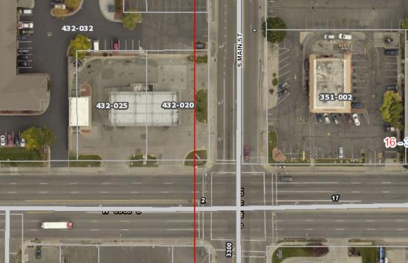
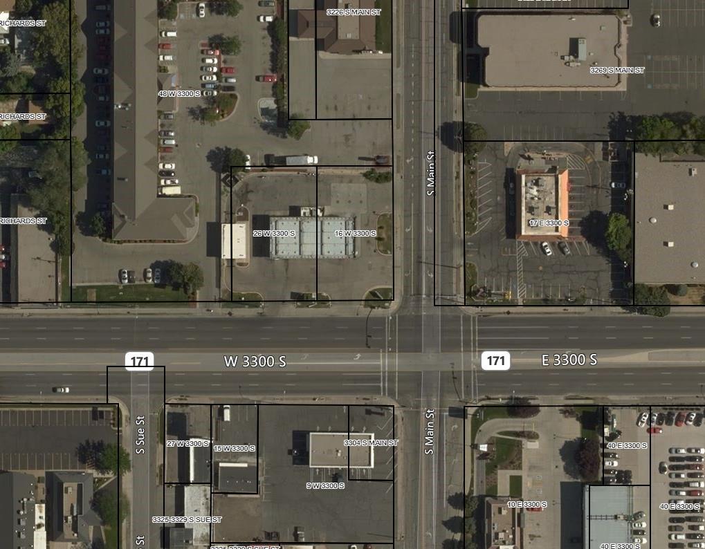
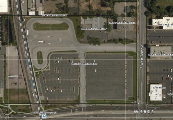
1 Planning Commission Work Meeting Minutes Thursday, October 18, 2018 City Council Chambers 220 East Morris Avenue Time 6:45 p.m. Commission Members Present: Jeremy Carter Susan Dickstein Chad Ewell Beth Floyd LeAnne Huff George Pechmann Staff Members Present: Michael Florence, Community and Economic Development Director Alexandra White, Senior Planner Jeff Attermann, City Planner Hannah Vickery, City Attorney 1. Discussion of Agenda Items. Jeremy Carter welcomed the attendees to the Planning Commission Work Meeting. Senior Planner, Alexandra White, introduced the items on the agenda. The first was final plat approval of a two-lot consolidation located on the corner of 3300 South and Main Street, specifically 16 West and 26 West on 3300 South. The property owner recently purchased the property, razed the gas station on the corner, and was proposing to build a new Carl s Jr. restaurant. The property is already zoned commercial; it simply needs to be consolidated to allow for a new building. Access and all required utility easements to and from the property have been examined. The Planning Commission is the land use authority. Staff recommended approval of the application. Ms. White presented the second item, a two-lot subdivision located at 3844 South West Temple, where the new Hub multifamily development is under construction. The Housing Authority of Salt Lake was previously approved by the Planning Commission for a Conditional Use Permit to develop The Hub, a mixed-use, 156-unit multi-family development. The property owner, UTA, has now decided to subdivide the property into two different parcels: the station and park and ride; and The Hub. At the last meeting it was continued to address technical issues and examine points of access. An ordinance amendment, Title 15, was drafted to correct the owner-occupied portion of the Subdivision Code. This came before the Planning Commission and the City Council and was resolved. The Planning Commission is the land use authority over a two-lot subdivision. Access easements were added to extend along the north and west boundary lines of Lot 1. There was a 26- foot shift in the west boundary line to accommodate the easement to allow access to and from the Hub site. The final plat application was provided in the staff report. Staff recommends approval of this application. The Planning Commission Work Meeting adjourned at approximately 6:57 p.m.
2 South Salt Lake City Planning Commission Meeting 2 October 18, 2018 Planning Commission Regular Meeting Minutes Thursday, October 18, 2018 City Council Chambers 220 East Morris Avenue Time 7:00 p.m. Commission Members Present: Jeremy Carter Susan Dickstein Chad Ewell Beth Floyd LeAnne Huff George Pechmann Staff Members Present: Michael Florence, Community and Economic Development Director Alexandra White, Senior Planner Jeff Attermann, City Planner Hannah Vickery, City Attorney Moment of Reflection: Pledge of Allegiance: Chair Carter Commissioner Pechmann Nomination of Chair Motion to elect Commissioner Carter to serve as Acting Chair. Motion: Second: Vote: Commissioner Pechmann Commissioner Dickstein Unanimous Approval of Agenda. Motion to approve the Agenda. Motion: Second: Vote: Commissioner Huff Commissioner Pechmann Unanimous
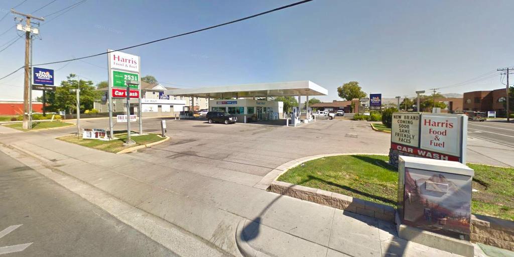
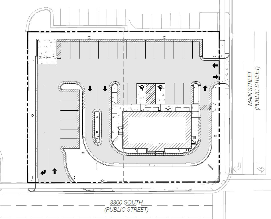
3 South Salt Lake City Planning Commission Meeting 3 October 18, 2018 NEW BUSINESS S Final Plat Approval for a Two-Lot Consolidation. Action Item Address Applicant 16 West 3300 South 26 West 3300 South TFC 3300 South, LLC Senior Planner, Alexandra White, presented the staff report and stated that it is for final plat approval for a two-lot consolidation. The parcel is located on the corner of Main Street and 3300 South, involving 16 West and 26 West. The property was recently purchased and the previously existing gas station was removed. The new owner wants to develop a new Carl s Jr. restaurant. In order to do so, to meet Building Code, the two parcels need to be consolidated into one. The Planning Commission is the land use authority on this application. The proposed use is allowed in the Commercial Corridor land use district. The building will face Main Street and 3300 South. There will be an access from both roads as well as a drive-thru that circulates per City Code. Staff completed the technical reviews of the layout. The Planning Commission is the land use authority on all applications petitioning to alter or amend a subdivision plat. As part of the application, the Commission should consider the General Plan. Specifically, goal LU1, which is to regulate land uses based on compatibility with surrounding uses, residential areas, and economic feasibility. It also includes maintaining residential business and industrial areas that are vibrant and where the health and safety of all are protected. Staff recommended final plat approval for the proposed lot consolidation subject to the following conditions: 1. The applicant will continue to work with City staff to make all technical corrections necessary prior to recording. The applicant has met this condition. 2. Prior to recording the plat into occupancy of any new development within these parcels, the applicant must submit the mylar with signatures and have it recorded with the County. 3. The applicant must bond for all infrastructure improvements on the property prior to construction. 4. All site improvements must be consistent with the requirements of the South Salt Lake City Municipal Code. 5. All items of the staff report.
4 South Salt Lake City Planning Commission Meeting 4 October 18, 2018 It was established that the tanks were removed when the gas station was demolished and an environmental study was conducted. The applicant underwent the necessary process. Elliot Smith was present on behalf of the applicant, TerraForm Companies, a retail development company headquartered in Salt Lake City. The company address was given as 6770 South 900 East in Midvale. Mr. Smith clarified that they purchased the property early this year and their first action was to pull the tanks. The Fire Department inspects all tank removals and tracks all such tanks for South Salt Lake City. The Final Certification Letter is a public record at the Department of Environmental Quality (DEQ) and can be requested through the State. Mr. Smith was also willing to the final certification to Ms. White for the Commission Members to review. Commissioner Carter opened the meeting to public comment. There were no public comments. The public hearing was closed. In response to the idea of making the environmental study part of the application, City Attorney, Hannah Vickery, described the legislative and administrative distinctions. The issue at hand involves administrative action by the Planning Commission. In an administrative action, the review is limited to whether the application complies with the law. If it does, it should be approved. If it does not comply with the law, it can be denied. The request is for is a lot consolidation, which falls under the City s Subdivision Ordinance and a number of relevant laws apply. The DEQ goes through a very robust permitting process in these circumstances, as they are the primary regulatory agency for environmental concerns. South Salt Lake City does have some regulatory authority delegated through the State to cities. The City has some enforcement authority in that regard, specifically in relation to storm water, groundwater, etc. However, making the environmental study part of the application would involve a separate process. Motion to APPROVE the agenda item for two-lot consolidation of 16 West 3300 South and 26 West 3300 South subject to conditions one through five as outlined by staff. Motion: Second: Vote: Commissioner Dickstein Commissioner Huff Unanimous CONTINUING BUSINESS S Final Plat Approval of a Two-Lot Minor Subdivision. Action Item Address 3844 South West Temple
5 South Salt Lake City Planning Commission Meeting 5 October 18, 2018 Applicant Housing Authority of Salt Lake Ms. White presented the staff report and stated that the Housing Authority of Salt Lake was previously approved by the Planning Commission for a Conditional Use Permit to develop a new multi-family, mixed-use building called The Hub, a 156-unit multifamily building. The property owner, UTA, has determined that the parcel should be subdivided into two lots so that The Hub sits on its own parcel, leaving the other as the bus and rail station for UTA facilities. The Planning Commission originally reviewed the request in June At that time, it was continued and staff brought back a Subdivision Ordinance Amendment. Technical revisions were made to the proposed plat since the Planning Commission last reviewed the application. The modifications pertained to access to and from both the proposed Lot 1 and Lot 2 of the subdivision. They consist of ingress and egress easements to allow The Hub s new multi-family development to have access to and from the building to a public road. The north easement at the top of Lot 1 is a 55-foot wide easement that serves both proposed parcels. The 26-foot easement that runs north to south serves the parking structure of the Hub to and from the public right-of-way as well as any other circulation from Lot 2. In order to accomplish the required easements, the lot line along the west boundary of lot 1 shifted. Ms. White explained that the Planning Commission is the land use authority for all subdivision plat approvals. Staff recommended approval of the two-lot subdivision plat for a parcel located at 3844 South West Temple subject to the following conditions: 1. The applicant will work with City staff to make all technical corrections necessary prior to recording. The applicant has met this condition. 2. Prior to recording the plat, it must be printed on mylar and they must obtain all required signatures. 3. They must either complete or post bonds for all public infrastructure work. This is also required as part of the building permit process. 4. All site improvements shall be installed consistent with the requirements of South Salt Lake City municipal code. 5. All items of the staff report. Motion to APPROVE the final plat for the two-lot minor subdivision on 3844 South West Temple with all five requirements as outlined by staff. Motion: Second: Vote: Commissioner Huff Commissioner Pechmann Unanimous
6
7
8


9


10


11
12
13
14
15

 N 89 58'30\" W 790.")
 1 inch = 20 ft. MAIN ST. STATE ST. 200 E SURVEYOR'S CERTIFICATE I, BRIAN A. LINAM DO HEREBY CERTIFY THAT I AM A PROFESSIONAL LAND SURVEYOR, AND THAT I HOLD CERTIFICATE NO.")


16 7.0' PUE STREET MONUMENT WEST TEMPLE & 2700 S FOUND BRASS CAP IN RING & LID SLCO SURVEYOR'S REF. MON. # SOUTH (PUBLIC ROAD) LOCATED IN THE SOUTHEAST QUARTER OF SECTION 25, TOWNSHIP 1 SOUTH, RANGE 1 WEST, ALSO IN THE SOUTHWEST QUARTER OF SECTION 30, TOWNSHIP 1 SOUTH, RANGE 1 EAST SALT LAKE BASE AND MERIDIAN ALSO A PORTION OF LOT 2, BLOCK 33 TEN ACRE PLAT "A", BIG FIELD SURVEY SOUTH SALT LAKE, SALT LAKE COUNTY, UTAH N 89 57'54" W ' (MEASURED) N 89 58'30" W ' (R2) 3300 MAIN CARL'S COMMERCIAL SUBDIVISION STREET MONUMENT MAIN ST. & 2700 S FOUND BRASS CAP IN RING & LID SLCO SURVEYOR'S REF. MON. #1S1E309A 3300 S NORTH GRAPHIC SCALE RICHARDS ST. SITE ( IN FEET ) 1 inch = 20 ft. MAIN ST. STATE ST. 200 E SURVEYOR'S CERTIFICATE I, BRIAN A. LINAM DO HEREBY CERTIFY THAT I AM A PROFESSIONAL LAND SURVEYOR, AND THAT I HOLD CERTIFICATE NO AS PRESCRIBED UNDER THE LAWS OF THE STATE OF UTAH. I FURTHER CERTIFY THAT BY AUTHORITY OF THE OWNERS, I HAVE MADE A SURVEY OF THE TRACT OF LAND SHOWN ON THIS PLAT AND DESCRIBED BELOW, AND HAVE COMBINED SAID TRACT OF LAND INTO ONE LOT HEREAFTER TO BE KNOWN AS: 3300 MAIN CARL'S COMMERCIAL SUBDIVISION AND THAT THE SAME HAS BEEN CORRECTLY SURVEYED AND STAKED ON THE GROUND AS SHOWN ON THIS PLAT. BOUNDARY DESCRIPTION BEGINNING AT A POINT SOUTH 89 54'00" WEST FEET FROM THE SOUTHEAST CORNER OF LOT 2, BLOCK 33, TEN ACRE PLAT "A", BIG FIELD SURVEY, SAID POINT ALSO BEING NORTH 00 03'30" EAST FEET ALONG THE MONUMENT LINE AND SOUTH 89 54'00" WEST FEET FROM THE STREET MONUMENT IN THE INTERSECTION OF MAIN STREET AND 3300 SOUTH; AND RUNNING THENCE SOUTH 89 54'00" WEST FEET ALONG THE NORTHERLY LINE OF 3300 SOUTH STREET; THENCE NORTH 00 03'30" EAST FEET; THENCE NORTH 89 54'00" EAST FEET TO A POINT ON THE WESTERLY LINE OF MAIN STREET; THENCE SOUTH 00 03'30" WEST FEET ALONG SAID WESTERLY LINE TO THE POINT OF BEGINNING. CONTAINS 26,463 SQ FT OR ACRES, MORE OR LESS 1 LOT N 00 04'08" E ' (MEASURED) N 00 03'40" E ' (R2) WEST TEMPLE (PUBLIC ROAD) INTOWN SUITES SALT LAKE SOUTH, LLC PARCEL# SET NAIL & WASHER (0.2' S & 0.2' W OF CURB WALL CORNER) N 00 03'30" E ' 7.0' PUE N 89 54'00" E ' LOT 1 26,463 SQ FT ACRES 20 WEST PARCEL# INTOWN SUITES SALT LAKE SOUTH, LLC SET NAIL & WASHER S 00 03'30" W ' 40.0' MON. TO MON. N 00 03'30" E ' (MEASURED) N 00 03'17" E ' (RECORD) MAIN STREET (PUBLIC ROAD) I W UTA TRAX VICINITY MAP LEGEND PUE WEST TEMPLE SUE ST. NORTH NTS SECTION CORNER (BRASS CAP MONUMENT) EX. BRASS CAP MONUMENT (RING & LID) BOUNDARY CORNER (SET 5 8 REBAR AND CAP OR AS NOTED ON PLAT) "STAMPED BENCHMARK ENG." BOUNDARY LINE ADJACENT PROPERTY STREET MONUMENT LINE EXISTING EASEMENT LOT LINE PUBLIC UTILITY EASEMENT BENCHMARK ENGINEERING & LAND SURVEYING 9138 SOUTH STATE STREET SUITE # 100 SANDY, UTAH (801) BRIAN A. LINAM PROFESSIONAL LAND SURVEYOR STATE OF UTAH OWNER'S DEDICATION AND CONSENT TO RECORD TFC 3300 CARLS, LLC, THE OWNER OF THE DESCRIBED TRACT OF LAND TO BE HEREAFTER KNOWN AS 3300 MAIN CARL'S COMMERCIAL SUBDIVISION, HEREBY CONSENTS AND GIVES APPROVAL TO THE RECORDING OF THIS PLAT FOR ALL PURPOSES SHOWN HEREIN. THERE ARE NO STREETS, EASEMENTS OR OTHER PROPERTY REFLECTED ON THIS PLAT TO BE DEDICATED TO THE PUBLIC. IN WITNESS WHEREOF, I,, AS MANAGING MEMBER OF TFC 3300 CARLS, LLC.,HAVE HEREUNTO SET MY HAND THIS DAY OF, TFC 3300 CARLS, LLC BY: ITS: MANAGING MEMBER ACKNOWLEDGMENT STATE OF UTAH County of Salt Lake } S.S. ON THIS DAY OF, IN THE YEAR 2018, BEFORE ME, A NOTARY PUBLIC, PERSONALLY APPEARED THE MANAGING MEMBER OF TFC 3300 CARLS, LLC PROVED ON THE BASIS OF SATISFACTORY EVIDENCE TO BE THE PERSON(S) WHOSE NAME(S) IS/ARE SUBSCRIBED TO IN THE FOREGOING OWNER'S DEDICATION AND CONSENT REGARDING RICHMOND PLACE, A PLANNED UNIT DEVELOPMENT AND WAS SIGNED BY HIM/HER ON BEHALF OF SAID RP1, LLC AND ACKNOWLEDGED THAT HE/SHE/THEY EXECUTED THE SAME. MY COMMISSION EXPIRES: (DATE) PRINT NAME COMMISSION NUMBER: (SIGNED) A NOTARY PUBLIC COMMISSIONED IN UTAH LOT LINE N 00 03'18" E (MEASURED) MONUMENT LINE COMCAST POB NOT SET SOUTHEAST CORNER LOT 2, BLOCK 33 APPROVED THIS DAY OF A.D. 20. S 89 54'00" W ' S 89 54'00" W ' S 89 54'00" W 40.00' CENTURYLINK APPROVED THIS DAY OF A.D. 20. NUMBER ACCOUNT SHEET STATEMENT OF ACCURACY, MINIMUM LINEAR CLOSURE OF 1:15,000. OF SHEETS STREET MONUMENT WEST TEMPLE & 3300 S FOUND BRASS CAP IN RING & LID SLCO SURVEYOR'S REF. MON. # SET NAIL & WASHER (0.2' W OF CURB WALL FACE) BENCHMARK ENGINEERING & LAND SURVEYING 9138 SOUTH STATE STREET SUITE # 100 SANDY, UTAH (801) SOUTH (PUBLIC ROAD) SALT LAKE COUNTY HEALTH DEPARTMENT APPROVED THIS DAY OF A.D., 20 SALT LAKE COUNTY HEALTH DEPARTMENT BASIS OF BEARINGS S 89 54'00" W ' (MEASURED) ' (RECORD) SOUTH SALT LAKE CITY COMMUNITY DEVELOPMENT APPROVED THIS DAY OF A.D., 20, BY THE SOUTH SALT LAKE CITY COMMUNITY DEVELOPMENT DEPARTMENT. COMMUNITY DEVELOPMENT DIRECTOR MOUNT OLYMPUS IMPROVEMENT DISTRICT FIRE MARSHAL APPROVED THIS DAY OF A.D., 20 FIRE MARSHAL APPROVED AS TO FORM THIS DAY OF, A.D., 20 BY THE SOUTH SALT LAKE CITY FIRE MARSHAL 33.00' STREET MONUMENT MAIN ST. & 3300 S FOUND BRASS CAP IN RING & LID SLCO SURVEYOR'S REF. MON. #1S1E303B PROJECT BENCHMARK - SEE NARRATIVE CITY ENGINEERING I HEREBY CERTIFY THAT I HAVE HAD THIS PLAT EXAMINED BY THIS OFFICE AND IT IS CORRECT IN ACCORDANCE WITH INFORMATION ON FILE IN THIS OFFICE APPROVED AS TO FORM THIS DAY OF A.D., 2018 SOUTH SALT LAKE CITY ENGINEER JORDAN VALLEY WATER CONSERVANCY DISTRICT APPROVED THIS DAY OF A.D., 20 DATE CITY ATTORNEY APPROVED AS TO FORM THIS DAY OF, A.D., 20 SOUTH SALT LAKE CITY ATTORNEY ROCKY MOUNTAIN POWER APPROVED THIS DAY OF, A.D. 20. CITY APPROVAL PRESENTED TO THE SOUTH SALT LAKE CITY COUNCIL THIS DAY OF, A.D.,20 AT WHICH TIME THIS SUBDIVISION WAS APPROVED AND ACCEPTED MAYOR DOMINION ENERGY APPROVED THIS DAY OF, A.D. 20. ATTEST 3300 MAIN CARL'S COMMERCIAL SUBDIVISION LOCATED IN THE SOUTHEAST QUARTER OF SECTION 25, ALSO IN THE SOUTHWEST QUARTER OF SECTION 30,TOWNSHIP 1 SOUTH, RANGE 1 WEST SALT LAKE BASE AND MERIDIAN ALSO LOCATED IN LOT 2, BLOCK 33, 10 ACRE PLAT "A", BIG FIELD SURVEY SOUTH SALT LAKE, SALT LAKE COUNTY, UTAH SALT LAKE COUNTY RECORDER FEE $ RECORDED # STATE OF UTAH, COUNTY OF SALT LAKE, RECORDED AND FILED AT THE REQUEST OF DATE TIME BOOK PAGE SALT LAKE COUNTY RECORDER SHEET 1 OF 1 NUMBER ACCOUNT SHEET OF SHEETS sp.dwg


17


18


19
20
21 S00 27'09"E ' 55.36' N00 27'09"W ' THE HUB OF OPPORTUNITY LOCATED IN SOUTHEAST QUARTER OF SECTION 36 TOWNSHIP 1 SOUTH, RANGE 1 WEST, SALT LAKE BASE AND MERIDIAN 3300 SOUTH STREET WEST TEMPLE ST H E O N G R R O C N N I E E K R S S 0 40' 80' SCALE: 1" = 40' LEGEND Δ ' 3844 SOUTH WEST TEMPLE STREET 206,305 SQ.FT ACRES INGRESS/EGRESS ACCESS EASEMENT (ROAD) 55.12' N89 30'43"E ' 26.00' 334,097 SQ.FT ACRES UTAH TRANSIT AUTHORITY INGRESS/EGRESS ACCESS EASEMENT (PRIVATE ROAD) 3848 SOUTH WEST TEMPLE STREET 127,792 SQ.FT ACRES THE HUB OF OPPORTUNITY 2162 West Grove Pkwy., Suite 400 Pleasant Grove, UT (801) DEVELOPED BY: TROY HART ' 26.00' ' HOUSING AUTHORITY OF THE COUNTY OF SALT LAKE 3595 South Main Street Salt Lake City, Utah PHONE No troyhart@hacsl.org N89 31'26"E ' (AS SURVEYED) MAY SOUTH STREET THE HUB OF OPPORTUNITY LOCATED IN SOUTHEAST QUARTER OF SECTION 36 TOWNSHIP 1 SOUTH, RANGE 1 WEST, SALT LAKE BASE AND MERIDIAN
Planning Commission Work Meeting Minutes Thursday, January 17, 2019 City Council Chambers 220 East Morris Avenue Time 6:30 p.m.
 Planning Commission Work Meeting Minutes Thursday, January 17, 2019 City Council Chambers 220 East Morris Avenue Time 6:30 p.m. Commission Members Present: Staff Members Present: Laura Vernon, Chair Jeremy
ADMINISTRATIVE HEARING STAFF REPORT Country Club Acres Second Amended Subdivision Amendment PLNSUB E Parkway Avenue December 12, 2013
 ADMINISTRATIVE HEARING STAFF REPORT Country Club Acres Second Amended Subdivision Amendment PLNSUB2013-00925 2167 E Parkway Avenue December 12, 2013 Planning Division Department of Community & Economic
Planning Commission Application Summary
 Planning Commission Application Summary Project Name: Academy Office Park Plat Amendment Request Address: 339 West 13490 South Current Zoning: CSD-DPMU Hearing Date: August 11, 2016 Summary of Request
PLANNING DIRECTOR. Approved by the Planning Director on this day of, A.D. 20. day of, A.D. 20. Approved by the Fire Chief on this
 Located in a portion of the West Half of Section 19, Township 5 South, Range 1 East, Salt Lake Base and Meridian. SURVEYOR'S CERTIFICATE I, the undersigned surveyor, do hereby certify that I am a registered
Planning Commission Work Meeting Minutes Thursday, February 7, 2019 City Council Chambers 220 East Morris Avenue Time 6:00 p.m.
 Planning Commission Work Meeting Minutes Thursday, February 7, 2019 City Council Chambers 220 East Morris Avenue Time 6:00 p.m. Commission Members Present: Staff Members Present: Laura Vernon, Chair Jeremy
ABBREVIATION LEGEND SITE INFORMATION:
 SITE INFORMATION: Current Zone: R-3 PUD, governed by Fox Hollow 2nd MDA Basis of Elevations: Northeast Corner of Section 13, T6S, R1W, S.L.B. & M Elevation: 4599.26 (Benchmark) ABBREVIATION LEGEND Owners:
PLANNING COMMISSION REPORT Non-Public Hearing Item
 PC Staff Report 09/21/2015 Item No. 2B - 1 PLANNING COMMISSION REPORT Non-Public Hearing Item PC Staff Report 09/212015 ITEM NO. 2B: FINAL PLAT FOR MORGAN ADDITION; 800 MONTEREY WAY (MKM) : Consider a
Master Plan, Zoning Amendment and Preliminary Subdivision
 Staff Report PLANNING DIVISION COMMUNITY & ECONOMIC DEVELOPMENT To: From: Salt Lake City Planning Commission Doug Dansie, 801-535-6182, doug.dansie@slcgov.com Date: September 9, 2015 Re: PLNPCM2014-00254/00253
MINOR PLAT FILING APPLICATION
 FILING APPLICATION Date of PC Meeting: Date of BCC Meeting: Fee Paid: 1. APPLICANT: DAYTIME PHONE: MAILING ADDRESS: LANDOWNER: DAYTIME PHONE: MAILING ADDRESS: AUTHORIZED AGENT: MAILING ADDRESS: RELATIONSHIP
SUBDIVISION APPLICATION
 SUBDIVISION APPLICATION Preliminary Plat Minor Plat Final Plat Amended Plat Applicant Name: Owner (if different from applicant) Name: Company: Company: Address: Address: City, State, Zip City, State, Zip
AGENDA HAYDEN PLANNING COMMISSION
 AGENDA HAYDEN PLANNING COMMISSION THURSDAY, DECEMBER 14, 2017 7:00 P.M. HAYDEN TOWN HALL 178 WEST JEFFERSON AVENUE REGULAR MEETING 1. CALL TO ORDER, MOMENT OF SILENCE & PLEDGE OF ALLEGIANCE 2. ROLL CALL
PLANNING COMMISSION STAFF REPORT
 PLANNING COMMISSION STAFF REPORT Alder-Robinson Subdivision Amending the Amended Plat of the Arcadia Heights Plat A Subdivision Case #PLNSUB2010-00044 2857 East 2100 South June 23, 2010 Applicant: Greg
CONCEPT PLAN APPLICATION Meeting with Staff Commercial Projects
 COMMUNITY DEVELOPMENT City of South Salt Lake Community Development Department 220 E. Morris Avenue South Salt Lake City, Utah 84115 Phone (801) 483-6011 Fax (801) 483-6060 CONCEPT PLAN APPLICATION Meeting
MINOR PLAT AMENDMENT APPLICATION CHECK APPLICABLE PERMIT ATTACHMENT:
 240 East Gammon Road Vineyard, Utah 84058 (801) 226-1929 MINOR PLAT AMMENDMENT APPLICATION Please Note: Attachment of request specific documents is required prior to processing your application. APPLICATION
Preliminary Subdivision Application (Minor) (Three (3) lots or less)
 (Three (3) lots or less)") Gunnison City Offices www.gunnisoncity.org 38 West Center Gunnison, Utah 84634 (435) 528 7969 Date of Application: Preliminary Subdivision Application (Minor) (Three (3) lots or less) APPLICANT INFORMATION
Gunnison City Offices www.gunnisoncity.org 38 West Center Gunnison, Utah 84634 (435) 528 7969 Date of Application: Preliminary Subdivision Application (Minor) (Three (3) lots or less) APPLICANT INFORMATION
SUBDIVISION APPLICATION
 SUBDIVISION APPLICATION City of Horn Lake Planning Department 3101 Goodman Road, W Horn Lake, MS 38637 662-342-3559 Fax: 662-342-3485 Applications due the 1st working day of the month. Submit application
AGENDA ITEM G-2 Public Works
 AGENDA ITEM G-2 Public Works STAFF REPORT City Council Meeting Date: 2/23/2016 Staff Report Number: 16-035-CC Consent Calendar: Adopt a resolution accepting Easements and approving the abandonment of two
E. 140TH AVE. VICINITY MAP SCALE: 1"=600' LAND USE TABLE NET AREA 599,946 SQFT AC. GROSS AREA 741,420 SQFT AC.
 SHEET OF PURPOSE STATEMENT: THIS PLAT IS INTENDED TO SUBDIVIDE. ACRES INTO SINGLE FAMILY ATTACHED LOTS, TRACTS, DEDICATE AND GRANT EASEMENTS. LEGAL DESCRIPTION: THE UNDERSIGNED BEING THE OWNER(S) OF A
Preliminary Subdivision Application (Major) (Four (4) lots or more)
 (Four (4) lots or more)") Gunnison City Offices www.gunnisoncity.org 38 West Center Gunnison, Utah 84634 (435) 528 7969 Date of Application: Preliminary Subdivision Application (Major) (Four (4) lots or more) APPLICANT INFORMATION
Gunnison City Offices www.gunnisoncity.org 38 West Center Gunnison, Utah 84634 (435) 528 7969 Date of Application: Preliminary Subdivision Application (Major) (Four (4) lots or more) APPLICANT INFORMATION
for the Logan Golf and Country Club; and
 CITY OF LOGAN ORDINANCE NO. 16-01 AN ORDINANCE VACATING PUBLIC RIGHTS-OF-WAY INCLUDING 700 NORTH AND 900 NORTH FROM 1600 EAST TO THE EASTERN CITY BOUNDARY, 2000 EAST FROM 700 NORTH TO 900 NORTH AND A BROAD
EASEMENT AGREEMENT. WHEREAS, Hall Brothers owns certain real property located in Weber County, Utah ( Hall Brothers Property );
;") When Recorded Return to: Parcel No. EASEMENT AGREEMENT THIS EASEMENT AGREEMENT ( Agreement ) is entered into this day of, 2016 by and between VALLEY DREAMS PROPERTIES, LLC, a Utah limited liability company
When Recorded Return to: Parcel No. EASEMENT AGREEMENT THIS EASEMENT AGREEMENT ( Agreement ) is entered into this day of, 2016 by and between VALLEY DREAMS PROPERTIES, LLC, a Utah limited liability company
COUNCIL AGENDA MEMO ITEM NO. III - #1
 COUNCIL AGENDA MEMO ITEM NO. III - #1 FROM: Anton Jelinek, Director of Utilities MEETING: October 24, 2017 SUBJECT: PRESENTER: Permanent Utility and Right-of-Way Easement Anton Jelinek Discussion: At the
FINAL PLAT GUIDE TO SUBDIVIDING PROPERTY. Background
 FINAL PLAT GUIDE TO SUBDIVIDING PROPERTY Background A final plat is the second step in the process of subdividing land into separate parcels for future sale or lease. Once a preliminary plat has been approved
The Filing Fee for a Minor Plat is $ PLUS $20.00 per lot created
 DEPARTMENT OF COMMUNITY DEVELOPMENT MINOR PLAT PROCEDURE The Filing Fee for a Minor Plat is $250.00 PLUS $20.00 per lot created Description: The purpose of a Minor Plat is to allow property to be platted
Community Development Department Council Chambers, 7:30 PM, December 1, 2016
 STAFF REPORT 2016-35P: Subdivision Community Development Department Council Chambers, 7:30 PM, December 1, 2016 To: From: Re: Paul Luke, Chairman, Skokie Plan Commission Mike Voitik, Planning Technician
VICINITY MAP SCALE 1'' = 2000'
 CITY CREEK ANNEXATION TO THE CITY OF THORNTON LOCATED IN THE SOUTHWEST QUARTER OF SECTION 11 AND THE WEST HALF OF SECTION 14, TOWNSHIP 1 SOUTH, RANGE 68 WEST OF THE 6TH PRINCIPAL MERIDIAN, COUNTY OF ADAMS,
PLANNING COMMISSION STAFF REPORT SURROUNDING LAND USES. Light Industrial, Office, UDOT Right of Way (Interstate- 15)
") PLANNING COMMISSION STAFF REPORT MEETING DATE: March 21, 2019 PROJECT NUMBER: S-18-014 REQUEST: Final Plat approval for a single lot subdivision ADDRESS: 3535 South 500 West 7 Parcels: 15-36-127-021-0000,
PLANNING COMMISSION STAFF REPORT MEETING DATE: March 21, 2019 PROJECT NUMBER: S-18-014 REQUEST: Final Plat approval for a single lot subdivision ADDRESS: 3535 South 500 West 7 Parcels: 15-36-127-021-0000,
STANDARDIZED LEGAL DESCRIPTIONS AND EXHIBITS
 STANDARDIZED LEGAL DESCRIPTIONS AND EXHIBITS Public Works Department, Engineering Division June 14, 2004 UNIFIED GOVERNMENT STANDARDIZED LEGAL DESCRIPTIONS AND EXHIBITS For: Roads, Bridges, Short Span
CITY OF STRONGSVILLE PLANNING COMMISSION APPLICATION. PARCEL SPLIT and/or ADJOINMENTS
 CITY OF STRONGSVILLE PLANNING COMMISSION APPLICATION PARCEL SPLIT and/or ADJOINMENTS Requires a Planning Commission application. After meeting with City Planner, George Smerigan (if necessary) regarding
PLANNING COMMISSION SUBDIVISION PLAT APPLICATION
 PLANNING COMMISSION SUBDIVISION PLAT APPLICATION Economic Development Department 3468 North Fulton Avenue Hapeville, Georgia 30354 Phone - 404.669.8269 Fax 404.669.3302 Rev. 09/23/16 1 The following information
CITY OF BEVERLY HILLS Department of Public Works and Transportation Civil Engineering Division FINAL MAP SUBMITTAL PROCESS Transmitted
 CITY OF BEVERLY HILLS Department of Public Works and Transportation Civil Engineering Division FINAL MAP SUBMITTAL PROCESS Transmitted From To* Planning Department Civil Engineering Division RKA Consulting
PLNSUB Meridian Commerce Center Subdivision Amendment & PLNPCM Meridian Commerce Center Street Closure
 Staff Report PLANNING DIVISION COMMUNITY & ECONOMIC DEVELOPMENT To: From: Salt Lake City Planning Commission Daniel Echeverria, 801-535-7165, daniel.echeverria@slcgov.com Date: September 4, 2014 Re: PLNSUB2014-000469
Community Development Department Council Chambers, 7:30 PM, July 20, 2017
 STAFF REPORT 2017-25P: Subdivision Community Development Department Council Chambers, 7:30 PM, July 20, 2017 To: From: Re: Paul Luke, Chairman, Skokie Plan Commission Mike Voitik, Planning Technician 2017-25P:
A Final Plat will be reviewed concurrently with any other development review application(s) that is required.
 that is required.") RELATED FACTS TO KNOW: Adams County Recording Requirements, Annexation, Common Wall Subdivision, Development Plan (PUD Development Permit), Fees, Helpful Contact Information, Lot Line Adjustment, Neighborhood
RELATED FACTS TO KNOW: Adams County Recording Requirements, Annexation, Common Wall Subdivision, Development Plan (PUD Development Permit), Fees, Helpful Contact Information, Lot Line Adjustment, Neighborhood
FINAL PLAT. Community Development Department 8101 Ralston Road Arvada, Colorado 80002
 FINAL PLAT Community Development Department 8101 Ralston Road Arvada, Colorado 80002 September 2015 FINAL SUBDIVISION PLAT Final Subdivision Plat Review Applications for a Final Plat shall be submitted
RIVERDALE CITY PLANNING COMMISSION APPLICATION FOR RESIDENTIAL SUBDIVISION SITE PLAN APPROVAL
 Community Development 4600 So. Weber River Drive Riverdale, Utah 84405 RIVERDALE CITY PLANNING COMMISSION APPLICATION FOR RESIDENTIAL SUBDIVISION SITE PLAN APPROVAL CASE NO: DATE SUBMITTED: APPLICANT S
A lot line or terminology adjustment will be reviewed concurrently with any other development review application(s) that are required.
 that are required.") RELATED FACTS TO KNOW: Adams County Recording Requirements, Annexation, Common Wall Subdivision, Development Plan (PUD Development Permit), Fees, Helpful Contact Information, Neighborhood Meeting, Park
RELATED FACTS TO KNOW: Adams County Recording Requirements, Annexation, Common Wall Subdivision, Development Plan (PUD Development Permit), Fees, Helpful Contact Information, Neighborhood Meeting, Park
INSTRUCTIONS FINAL PLAT APPROVAL APPLICATION
 INSTRUCTIONS FINAL PLAT APPROVAL APPLICATION 1. The applicant/agent shall fill out the attached application. The attached application form must be completely filled in before it can be filed. Portions
Land Use & Development Application
 Salt Lake County Public Works Department Planning and Development Services Division 2001 S. State Street #N-3600, Salt Lake City, UT 84190-4050 Phone 385-468-6700 FAX: 385-468-6674 Visit our web site:
NON-EXCLUSIVE ROADWAY AND UTILITY EASEMENT DEED AND AGREEMENT
 RETURN TO: STOGSDILL LAW OFFICE, P.C. 505 West Main, Suite 313 Lewistown, Montana 59457 (406) 538-2623 NON-EXCLUSIVE ROADWAY AND UTILITY EASEMENT DEED AND AGREEMENT THIS EASEMENT DEED AND AGREEMENT is
Magna Metro Township Council Meeting Public Meeting Agenda. Tuesday, July 18, :00 P.M.
 Planning and Development Services 2001 S. State Street N3-600 Salt Lake City, UT 84190-4050 Phone: (385) 468-6700 Fax: (385) 468-6674 www.pwpds.slco.org Magna Metro Township Council Meeting Public Meeting
SUBDIVISION APPLICATION
 STAFF USE ONLY Date Submitted: Received by: Fee paid: Project # REQUIRED SUBMITTALS Application Fee: $600.00 (up to 5 lots) + $50.00 (per lot above 5) Publication Fee: $300.00 Mailing Fee: $6.00 per hearing
Agenda Item No. 6E May 23, Honorable Mayor and City Council Attention: Jeremy Craig, Interim City Manager
 Agenda Item No. 6E May 23, 2017 TO: FROM: SUBJECT: Honorable Mayor and City Council Attention: Jeremy Craig, Interim City Manager Shawn L. Cunningham, Director of Public Works (Staff Contact: Tim Burke,
MINOR SUBDIVISION PLAT
 MINOR SUBDIVISION PLAT Community Development Department 8101 Ralston Road Arvada, Colorado 80002 MINOR SUBDIVISION PLAT Subdivisions consisting of five (5) or fewer lots are eligible for the minor subdivision
QUEBEC STREET EAST 130TH AVENUE ONEIDA STREET E. 130TH AVE. VALENTIA ST TAMARAC ST EAST 128TH AVENUE MOACO STREET BACHMAN DR. SITE QUINCE ST.
 SHEET OF CASE NO.: SUBA - PURPOSE STATEMENT: THIS PLAT IS INTENDED TO SUBDIVIDE. ACRES INTO SINGLE FAMILY LOTS, AND TRACTS FOR PARKS, OPEN SPACE, DRAINAGE AND DETENTION, DEDICATE RIGHT-OF-WAY AND GRANT
QUEBEC STREET EAST 130TH AVENUE ONEIDA STREET E. 130TH AVE. VALENTIA ST TAMARAC ST EAST 128TH AVENUE MONACO STREET BACHMAN DR. SITE QUINCE ST.
 SHEET OF CASE NO.: SUBA 0-0 PURPOSE STATEMENT: THIS PLAT IS INTENDED TO SUBDIVIDE. ACRES INTO 0 SINGLE FAMILY LOTS, AND TRACTS FOR PARKS, OPEN SPACE, DRAINAGE AND DETENTION, DEDICATE RIGHT-OF-WAY AND GRANT
MINOR SUBDIVISION PLAT
 MINOR SUBDIVISION PLAT Community Development Department 8101 Ralston Road Arvada, Colorado 80002 September 2015 MINOR SUBDIVISION PLAT Subdivisions consisting of five (5) or fewer lots are eligible for
when the following proceedings, among others were held and done, to-wit:
 STATE OF COLORADO ) COUNTY OF ADAMS ) At a regular meeting of the Board of County Commissioners for Adams County, Colorado, held at the Administration Building in Brighton, Colorado on the 2 nd day of
MAJOR RESIDENTIAL AND NONRESIDENTIAL SUBDIVISIONS
 Lawrence-Douglas County MAJOR RESIDENTIAL AND NONRESIDENTIAL SUBDIVISIONS Preliminary Plats The applicant shall schedule a Pre-Application meeting with Planning Staff at least seven (7) working days prior
Community Development Department
 Community Development Department SUBJECT: Consideration of a Resolution for a Single-Lot Subdivision for the Skyler Park Subdivision at 626 Forest Road AGENDA ITEM: 9.b.v MEETING DATE: November 17, 2015
ADMINISTRATIVE HEARING STAFF REPORT
 ADMINISTRATIVE HEARING STAFF REPORT Nin Tech West II Subdivision Amendment PLNSUB2013-00980 1515 & 1555 South Gramercy Road February 13, 2014 Planning Division Department of Community & Economic Development
APPENDIX C: PLAT SPECIFICATIONS AND CERTIFICATES
 APPENDIX C: PLAT SPECIFICATIONS AND CERTIFICATES A. Drawing. All plats for recording must be submitted on photographically reproducible and dimensionally stable polyester sheets such as Mylar, Cronar or
CITY OF LANCASTER CITY ENGINEERING DIVISION FINAL MAP SUBMITTAL PACKAGE FINAL MAP APPLICATION
 CONTENTS Page 1 - Final Map Application Page 2 - Financial Interest Disclosure Page 3-1 st Submittal Checklist Page 4 - Required Easement Tracking Sheet Page 5 - Easement Submittal Requirements Checklist
MINOR SUBDIVISION PLAT
 CHECKLIST HANCOCK COUNTY AREA PLAN COMMISSION A subdivider shall submit to the Plan Commission office an application and an accompanying plat for a minor subdivision. The plat shall be based on a boundary
REQUIREMENTS FOR FINAL SITE PLAN Final Site Plan must be submitted within 12 months of a Conceptual Site Plan approval
 REQUIREMENTS FOR FINAL SITE PLAN Final Site Plan must be submitted within 12 months of a Conceptual Site Plan approval The applicant must submit a complete application for final site plan approval to the
WHEREAS, are existing rights-of-way that extend through Utah State University property that are used the Golf Country Club; and
 CITY Of LOGAN ORDINANCE NO. 16-01 AN ORDINANCE VACATING PUBLIC RIGHTS-Of-WAY INCLUDING 100 NORTH AND 900 NORTH from 1600 EAST TO THE EASTERN CITY BOUNDARY, 2000 EAST from 100 NORTH TO 900 NORTH AND A BROAD
STANDARD LANGUAGE FORMAT GUIDE PLANNING SERVICES DIVISION
 A. OWNERSHIP CERTIFICATE The purpose of the ownership certificate is to identify the owner and provide the Volume and Page of Deed Records, verifying the ownership. When the property owner is a corporation,
Sketch & Legal Description of Mitigation Bank and Ingress/Egress Access Easements
 Appendix H: Sketch & Legal Description of Mitigation Bank and Ingress/Egress Access Easements Tippen Bay Wetland Mitigation Bank DeSoto County, Florida Prepared by: September, 2017 Original file
Preliminary Plat/Final Plat Application
 Melissa Municipal Center 3411 Barker Avenue Melissa, Texas 75454 Phone: (972) 838-2036 Applicant: Date: Address: Phone: Contact: Fax: E-mail: Propose Addition Name: Acres: Existing Zoning: Propose Zoning:
PRELIMINARY PLAT CHECK LIST
 PRELIMINARY PLAT CHECK LIST Name of Proposed Subdivision: The following items must be included with the initial submittal of a Preliminary Plat: Application, filled out completely Project Narrative Pre-application
I. PARCEL MAP STATEMENTS II. FINAL MAP STATEMENTS III. GENERAL NOTES ON PARCEL/FINAL MAPS FOR CONDOMINIUMS IV. RECORD OF SURVEY STATEMENTS
 These statements are compiled for the convenience of the reader and are not meant to redefine or conflict with applicable California State Law. In the event of a conflict, the applicable law shall prevail.
Final Subdivision Plat
 Final Subdivision Plat Application Packet Public Works Department New Development Division 175 East 200 North St. George, UT 84770 Office (435) 627-4120 Dear Applicant, This packet has been prepared to
WATERFORD LANDING COMMUNITY DEVELOPMENT DISTRICT REGULAR MEETING AGENDA
 WATERFORD LANDING COMMUNITY DEVELOPMENT DISTRICT REGULAR MEETING AGENDA January 31, 2019 Waterford Landing Community Development District OFFICE OF THE DISTRICT MANAGER 2300 Glades Road, Suite 410W Boca
CITY OF LARKSPUR Staff Report
 DATE: August 29, 2011 CITY OF LARKSPUR Staff Report September 7, 2011 City Council Meeting TO: FROM: SUBJECT: Larkspur City Council Hamid Shamsapour, Director of Public Works A Resolution of the City Council
Resolution : A Resolution Recommending Approval Of Preliminary and Final Plats For Emma Krumbees Third Addition
 MEMORANDUM June 11, 2018 TO: FROM: SUBJECT: Planning Chairperson Carter Planning Commission Members Administrator Meyer Cynthia Smith Strack, Community Development Director Resolution 18 013: A Resolution
PLANNING SERVICES MEMORANDUM
 PLANNING SERVICES MEMORANDUM March 13, 2017 TO: FROM: SUBJECT: City Council Brian Schweigl, Associate Planner Consideration and action on final Certified Survey Map (CSM) 17002-C, City of Janesville, 2
LAND SPLIT APPLICATION AND SUBMITTAL REQUIREMENTS
 LAND SPLIT APPLICATION AND SUBMITTAL REQUIREMENTS PARCELS 2.5> ACRES OR SMALLER: THIS APPLICATION IS REQUIRED TO DIVIDE LAND INTO TWO OR THREE PARCELS. PARCELS LARGER THAN 2.5 ACRES: THIS APPLICATION IS
AGENDA BASEHOR PLANNING COMMISSION February 13, :00 p.m. Basehor City Hall
 AGENDA BASEHOR PLANNING COMMISSION February 13, 2018 7:00 p.m. Basehor City Hall 1. Call to Order 2. Pledge of Allegiance and Roll Call 3. Approval of Minutes of the preceding meeting. a. Minutes of the
ZONE DISTRICT, GENERAL PLAN, & MASTER PLAN MAP AMENDMENT Application Packet
 ZONE DISTRICT, GENERAL PLAN, & MASTER PLAN MAP AMENDMENT Application Packet Community Development Department 1020 East Pioneer Road, Draper, UT 84020 (801) 576-6539 Fax (801) 576-6526 Dear Applicant, This
MINUTES OF A REGULAR PLANNING COMMISSION MEETING HELD, TUESDAY, OCTOBER 11, :30 P.M. ROCKVILLE CITY HALL
 28 MINUTES OF A REGULAR PLANNING COMMISSION MEETING HELD, TUESDAY, OCTOBER 11, 2011 6:30 P.M. ROCKVILLE CITY HALL The meeting was called to order by Chair Toni Honer. Roll call was taken and the following
DISTRICT. Huntington Beach. FIM 40-40C-3 APN and
 RECORDING REQUESTED BY W HEN RECORDED MAIL TO SOUTHERN CALIFORNIA EDISON COMPANY 2131 WALNUT GROVE AVENUE 2 ND FLOOR GO3 ROSEMEAD, CA 91770 Attn: Title and Real Estate Services SPACE ABOVE THIS LINE FOR
PLANNING AND ZONING COMMISSION PUBLIC SAFETY COMMUNITY ROOM, 808 COPPERMINE RD September 11, 2018
 PLANNING AND ZONING COMMISSION SPECIAL M E E T I N G N O T I C E C I T Y OF P A G E PLANNING AND ZONING COMMISSION PUBLIC SAFETY COMMUNITY ROOM, 808 COPPERMINE RD September 11, 2018 PAGE, ARIZONA 5:30
REVIEWED BY: Administrator Counsel Program Mgr.: Tiffany Schaufler Board Committee Engineer Other
 Minnehaha Creek Watershed District REQUEST FOR BOARD ACTION MEETING DATE: May 11, 2017 TITLE: Authorization to Grant a Temporary Easement to the City of Minnetrista RESOLUTION NUMBER: 17-034 PREPARED BY:
B. The proposed parcel(s) of land shall be in compliance with the current zoning requirements.
 of land shall be in compliance with the current zoning requirements.") SECTION 14-900 SUBDIVISION EXEMPTION 14-901 INTENT To establish criteria and a review process whereby the Board of County Commissioners may grant Exemptions from the definition of the terms subdivision
SECTION 14-900 SUBDIVISION EXEMPTION 14-901 INTENT To establish criteria and a review process whereby the Board of County Commissioners may grant Exemptions from the definition of the terms subdivision
Regular Agenda / Public Hearing for Board of Commissioners meeting January 7, 2015
 Rebecca W. Arnold, Commissioner Sara M. Baker, Commissioner Jim D. Hansen, Commissioner Kent Goldthorpe, Commissioner Paul Woods, Commissioner TO: FROM: ACHD Board of Commissioners & Bruce S. Wong, Director
City Council Agenda Item #13_ Meeting of March 6, 2017
 City Council Agenda Item #13_ Meeting of March 6, 2017 Description Recommendation Resolution vacating a sump easement and drainage and utility easements located at 1555 Linner Road. Hold the public hearing
MINOR SUBDIVISION FINAL PLAT APPLICATION Town of Apex, North Carolina
 MINOR SUBDIVISION FINAL PLAT APPLICATION Town of Apex, North Carolina This document is a public record under the North Carolina Public Records Act and may be published on the Town s website or disclosed
PARCEL MAP Rev JAN 01, 2010
 PARCEL MAP OWNER'S CERTIFICATE/STATEMENT (INDIVIDUAL) I HEREBY CERTIFY THAT I AM THE SOLE OWNER OF AND HAVE THE RIGHT, TITLE, AND INTEREST IN AND TO THE REAL PROPERTY INCLUDED WITHIN THE SUBDIVISION SHOWN
, Assistant County Attorney. when the following proceedings, among others were had and done, to-wit: RESOLUTION NO.
 STATE OF COLORADO ) )ss County of Garfield ) At a regular meeting of the Board of County Commissioners for Garfield County, Colorado, held in the Commissioners' Meeting Room, Garfield County Administration
PARK COUNTY APPLICATION FOR LOT CONSOLIDATION (THERE IS NO APPLICATION FEE FOR LOT CONSOLIDATIONS)
") PARK COUNTY APPLICATION FOR LOT CONSOLIDATION (THERE IS NO APPLICATION FEE FOR LOT CONSOLIDATIONS) A Lot Consolidation is processed by the Planning Department Staff. A public hearing is not required. PROCEDURE
PARK COUNTY APPLICATION FOR LOT CONSOLIDATION (THERE IS NO APPLICATION FEE FOR LOT CONSOLIDATIONS) A Lot Consolidation is processed by the Planning Department Staff. A public hearing is not required. PROCEDURE
APPLICATION PACKET SUBDIVISION PLAT REVIEW TENTATIVE PRELIMINARY PLAT
 APPLICATION PACKET SUBDIVISION PLAT REVIEW TENTATIVE PRELIMINARY PLAT COMMUNITY DEVELOPMENT DEPARTMENT CHARTER TOWNSHIP OF PLYMOUTH 9955 N. Haggerty Road Plymouth, MI 48170 Fees Revised 7/01/2012 APPLICATION
PROCEDURE FOR CLOSING STREETS AND ALLEYS UNDER N.C.G.S. 160A-299 CITY OF GASTONIA, LEGAL DEPT., P. O. BOX 1748, GASTONIA, NC ( )
") PROCEDURE FOR CLOSING STREETS AND ALLEYS UNDER N.C.G.S. 160A-299 CITY OF GASTONIA, LEGAL DEPT., P. O. BOX 1748, GASTONIA, NC 28053 (866-6735) 1. Applicant requests closing of street or alley through the
PROCEDURE FOR CLOSING STREETS AND ALLEYS UNDER N.C.G.S. 160A-299 CITY OF GASTONIA, LEGAL DEPT., P. O. BOX 1748, GASTONIA, NC 28053 (866-6735) 1. Applicant requests closing of street or alley through the
FINAL PLAT AMENDMENT APPLICATION Minor / Major / Administrative (Revised 3/1/2017)
") FINAL PLAT AMENDMENT APPLICATION Minor / Major / Administrative (Revised 3/1/2017) Lana Gallegos, AICP, Senior Planner 970-524-1729 Cindy Schwartz, Assistant Planner 970-524-1750 DATE APPLICATION SUBMITTED:
FINAL PLAT AMENDMENT APPLICATION Minor / Major / Administrative (Revised 3/1/2017) Lana Gallegos, AICP, Senior Planner 970-524-1729 Cindy Schwartz, Assistant Planner 970-524-1750 DATE APPLICATION SUBMITTED:
CITY OF VALDEZ APPLICATION FOR SUBDIVISION
 CITY OF VALDEZ APPLICATION FOR SUBDIVISION The subdivision of any land within the city limits of the City of Valdez is regulated by Title 16 of the Valdez Municipal Code. 16.04.020 Definitions. Subdivision
JOEL ROJAS, COMMUNITY DE'WPfiENT DIRECTOR ACCEPTANCE OF A SEWER EASEMENT DEED TO PROVIDE ADDITIONAL EASEMENT AREA TO ALLOW
 CITY OF RANCHO PALOS VERDES COMMUNITY DEVELOPMENT DEPARTMENT MEMORANDUM TO: FROM: DATE: SUBJECT: HONORABLE MAYOR & CITY COUNCIL MEMBERS u - JOEL ROJAS, COMMUNITY DE'WPfiENT DIRECTOR JUNE 3, 2014 ACCEPTANCE
Exhibit A: REAL ESTATE TRANSFER AGREEMENT
 Exhibit A: REAL ESTATE TRANSFER AGREEMENT This agreement is made between the City of Urbana, Illinois, a municipal corporation of the State of Illinois (the Seller ), and Homestead Corporation of Champaign-Urbana,
STAFF REPORT. Honorable Mayor and City Council
 STAFF REPORT DATE May 22, 2013 TO: FROM: Honorable Mayor and City Council Superintendent, Brandon Graham SUBECT: PURCHASE UTILITY EASEMENT FROM INTERMOUNTAIN POWER AGENCY LOCATED AT EAST SIDE OF 1650 WEST,
Perry City Planning Commission Perry City Offices, 3005 South 1200 West April 5, :00 PM
 Perry City Planning Commission Perry City Offices, 3005 South 1200 West April 5, 2012 7:00 PM Members Present: Chairman Jerry Nelson, Commissioner Esther Montgomery, Commissioner Todd Bischoff, Commissioner
CITY OF VICTORIA Location Map
 CITY OF VICTORIA Location Map Map Date: 2/8/2019 ± 0 0.05 0.1 0.2 0.3 0.4 mi Hawks Pointe City of Victoria, Carver County GIS CITY OF VICTORIA COUNTY OF CARVER STATE OF MINNESOTA ORDINANCE NO. XX AN
MAJOR RESIDENTIAL AND NONRESIDENTIAL SUBDIVISIONS
 MAJOR RESIDENTIAL AND NONRESIDENTIAL SUBDIVISIONS Final Plats The applicant shall schedule a Pre-Application meeting with Planning Staff at least seven (7) working days prior to submittal of the application.
SUBMISSION REQUIREMENTS AND INSTRUCTIONS FOR MINOR REVISIONS TO PUD PLANS
 WEST CHESTER TOWNSHIP, BUTLER COUNTY, OHIO COMMUNITY DEVELOPMENT DEPARTMENT 9577 Beckett Road, Suite 100, West Chester, Ohio 45069 TELEPHONE: (513) 777-4214 www.westchesteroh.org SUBMISSION REQUIREMENTS
City of Grand Forks Staff Report
 City of Grand Forks Staff Report Planning and Zoning Commission March 6, 2019 City Council March 18, 2019 Agenda Item: 4-1 (Preliminary) Preliminary approval of the plat of University Place First Resubdivision
The City Council of the City of Sulphur, Louisiana, met in special session at its
 July 12, 2018 The City Council of the City of Sulphur, Louisiana, met in special session at its regular meeting place in the Council Chambers, Sulphur, Louisiana, on July 12, 2018 at 5:00 p.m., after full
COUNTY OF ADAMS, STATE OF COLORADO E. 40TH AVE. TOWER RD. E. 38TH AVE. SALIDA ST. HIGH LINE CANAL PROJECT LOCATION E. 32ND PKWY.
 LEGAL DESCRIPTION:, GATEWAY EAST AT TOWER SUBDIVISION FILING NO. 1, SAID PARCEL CONTAIN 598,154 SQUARE FEET OR MORE OR LESS GENERAL NOTES: 1. NOTICE: ACCORDING TO COLORADO LAW YOU MUST COMMENCE ANY LEGAL
City of Sanibel. Planning Department STAFF REPORT
 City of Sanibel Planning Department STAFF REPORT Planning Commission Meeting: July 23, 2013 Planning Commission Agenda Item: No 7b. Application Number: 13-7438DP Applicant Name: Attorney Beverly Grady
APPLICATION PROCEDURES FOR A PLAT AMENDMENT OR REVISION
 APPLICATION PROCEDURES FOR A PLAT AMENDMENT OR REVISION DEFINITION: Any revision or amendment to an approved recorded or unrecorded final plat. A revision (not recorded) does not require a public hearing
TEMPORARY ACCESS/UTILITY EASEMENT AGREEMENT
 Prepared by: RETURN: R. Brian Shutt, Esq. City Attorney's Office 200 N.W. 1st Avenue Delray Beach, Florida 33444 TEMPORARY ACCESS/UTILITY EASEMENT AGREEMENT THIS TEMPORARY ACCESS/UTILITY EASEMENT AGREEMENT
NEIGHBORHOOD MEETING
 NEIGHBORHOOD MEETING Community Development Department 8101 Ralston Road Arvada, Colorado 80002 NEIGHBORHOOD MEETINGS The City of Arvada promotes citizen participation in the development review process.
C O M M U N I T Y D E VELOPMENT S E R VICES PLEASE CHECK ALL THAT APPLY
 LAND USE MASTER INVOICE C O M M U N I T Y D E VELOPMENT S E R VICES 435 MARTIN STREET, STE. 3000 BLAINE, WA 98230 PHONE: (360) 332-8311 FAX: (360) 543-9978 Total Fees $ FOR OFFICIAL USE ONLY I, the applicant/owner,
City of Edwardsville, Kansas Special Benefit District Policy
 City of Edwardsville, Kansas Special Benefit District Policy Date Adopted: September 12, 2011 Section 1. Objective The objective is to establish a policy to finance public streets, sanitary sewers, water