City Council Information Form
|
|
|
- Marlene Hunter
- 5 years ago
- Views:
Transcription
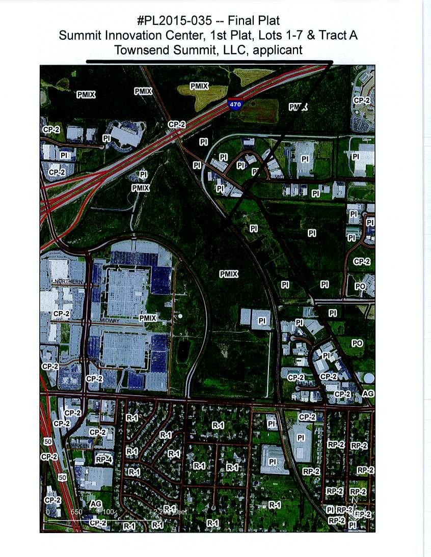
1 City Council Information Form DATE: 06/12/2015 ASSIGNED STAFF: Christina Stanton DEPARTMENT: Planning&Development TYPE OF FORM: Ordinances Form No.: 4898 APPROVALS: None ISSUE/REQUEST: AN ORDINANCE ACCEPTING FINAL PLAT ENTITLED SUMMIT INNOVATION CENTER, 1ST PLAT, LOTS 1 7 AND TRACT A, AS A SUBDIVISION TO THE CITY OF LEE S SUMMIT, MISSOURI. KEY ISSUES: This final plat application is for Summit Innovation Center, 1st Plat, Lots 1 7 and Tract A, located on the northeast corner of NW Chipman Rd. and NW Ward Rd., west of Missouri Pacific Railroad. The proposed final plat consists of 7 lots and one common area tract on acres. The proposed final plat is substantially consistent with the approved preliminary plat. PROPOSED CITY COUNCIL MOTION: FIRST MOTION: I move for a second reading of AN ORDINANCE ACCEPTING FINAL PLAT ENTITLED SUMMIT INNOVATION CENTER, 1ST PLAT, LOTS 1 7 AND TRACT A, AS A SUBDIVISION TO THE CITY OF LEE S SUMMIT, MISSOURI. SECOND MOTION: I move for adoption of AN ORDINANCE ACCEPTING FINAL PLAT ENTITLED SUMMIT INNOVATION CENTER, 1ST PLAT, LOTS 1 7 AND TRACT A, AS A SUBDIVISION TO THE CITY OF LEE S SUMMIT, MISSOURI. BACKGROUND:(including location, programs/departments affected, and process issues) IMPACT/ANALYSIS: TIMELINE Start: Finish: OTHER INFORMATION/UNIQUE CHARACTERISTICS: STAFF RECOMMMENDATION Staff recommends APPROVAL of the final plat.
2 OTHER BOARDS AND COMMISSIONS ASSIGNED: Planning Commission DATE: 06/09/2015 ACTION: Voted by Consent Agenda to approve Appl. #PL FINAL PLAT Summit Innovation Center, 1ST Plat, Lots 1 7 and Tract A; Townsend Summit, LLC, applicant COUNCIL COMMITTEE ASSIGNED: Not Applicable DATE: ACTION: List of Reference Documents Attached 1. Ordinance 2. SIC FP PC Letter 3. SIC FP 4. SIC Location Map
3 BILL NO AN ORDINANCE ACCEPTING FINAL PLAT ENTITLED SUMMIT INNOVATION CENTER, 1 ST PLAT, LOTS 1-7 AND TRACT A, AS A SUBDIVISION TO THE CITY OF LEE S SUMMIT, MISSOURI. WHEREAS, Application PL , submitted by Townsend Summit, LLC, requesting approval of the final plat entitled Summit Innovation Center, 1 st Plat, Lots 1-7 and Tract A, was referred to the Planning Commission as required by the Unified Development Ordinance No. 5209; and, WHEREAS, the Planning Commission considered the final plat on June 9, 2015, and rendered a report to the City Council recommending that the plat be approved. NOW THEREFORE, BE IT ORDAINED BY THE CITY COUNCIL OF THE CITY OF LEE S SUMMIT, MISSOURI, as follows: SECTION 1. That the final plat entitled Summit Innovation Center, 1 st Plat, Lots 1-7 and Tract A is a subdivision in Section 31, Township 48 North, Range 32 West, in Lee s Summit, Missouri more particularly described as follows: All of Lot 8, of the recorded plat of SUMMIT FAIR, SECOND PLAT, Lots 8, 10-14, and Tract C, a subdivision in Section 31, Township 48 North, Range 31 West, and Section 36, Township 48 North, Range 32 West, of the Fifth Principal Meridian, in Lee s Summit, Jackson County, Missouri, recorded August 7, 2008 and filed as Document Number 2008E in Book 122, Page 1, and all of Lot 11A of the recorded plat of SUMMIT FAIR, LOT 11A & 11B, a minor subdivision in Section 31, Township 48 North, Range 31 West, and Section 36, Township 48 North, Range 32 West, of the Fifth Principal Meridian, in Lee s Summit, Jackson County, Missouri, recorded July 29, 2011 and filed as Document Number 2011E in Book 138, page 1. SECTION 2. That the proprietor of the above described tract of land ( Proprietor ) has caused the same to be subdivided in the manner shown on the accompanying plat, which subdivision shall hereafter be known as Summit Innovation Center, 1 st Plat, Lots 1-7 and Tract A. SECTION 3. That the roads and streets shown on this plat and not heretofore dedicated to public use as thoroughfares shall be dedicated as depicted on the plat. The City Council hereby authorizes the Director of Planning and Codes Administration, on behalf of the City of Lee s Summit, Missouri, to accept the land or easements dedicated to the City of Lee s Summit for public use and shown on the accompanying plat, upon the subdivider filing and recording a final plat in accordance with Article 16, Subdivisions, Unified Development Ordinance ( UDO ) of the City, which plat shall conform to the accompanying plat, and hereby authorizes acceptance of the public improvements required by this ordinance and Article 16 of the UDO of the City, upon the Director of Public Works certifying to the Director of Planning and Codes Administration and the City Clerk that the public improvements have been constructed in accordance with City standards and specifications. Page 1
4 BILL NO SECTION 4. That the approval granted by this ordinance is done under the authority of Section of the Revised Statutes of Missouri and Section of the UDO because all subdivision-related public improvements required by the UDO have not yet been completed. In lieu of the completion and installation of the subdivision-related public improvements prior to the approval of the plat, the Proprietor has, in accordance with Section of the UDO, deposited an irrevocable letter of credit to secure the actual construction and installation of said public improvements, and the City hereby accepts same. No building permit shall be issued until the required public improvements are available to each lot for which a building permit is requested in accordance with the Design and Construction Manual. SECTION 5. That an easement shall be granted to the City of Lee s Summit, Missouri, to locate, construct and maintain or to authorize the location, construction, and maintenance of poles, wires, anchors, conduits, and/or structures for water, gas, sanitary sewer, storm sewer, surface drainage channel, electricity, telephone, cable TV, or any other necessary public utility or services, any or all of them, upon, over, or under those areas outlined or designated upon this plat as Utility Easements (U.E.) or within any street or thoroughfare dedicated to public use on this plat. Grantor, on behalf of himself, his heirs, his assigns and successors in interest, shall waive, to the fullest extent allowed by law, including, without limitation, Section , RSMo. (2006), any right to request restoration of rights previously transferred and vacation of any easement granted by this plat. SECTION 6. That building lines or setback lines are hereby established as shown on the accompanying plat and no building or portion thereof shall be constructed between this line and the street right-of-way line. SECTION 7. That the final plat substantially conforms to the approved preliminary plat and to all applicable requirements of the Code. SECTION 8. That the City Council for the City of Lee s Summit, Missouri, does hereby approve and accept, as a subdivision to the City of Lee s Summit, Missouri, the final plat entitled Summit Innovation Center, 1 st Plat, Lots 1-7 and Tract A, attached hereto and incorporated herein by reference. SECTION 9. That this ordinance shall be in full force and effect from and after the date of its passage and adoption, and approval by the Mayor. PASSED by the City Council for the City of Lee s Summit, Missouri, this day of, ATTEST: Mayor Randall L. Rhoads City Clerk Denise R. Chisum Page 2
5 BILL NO APPROVED by the Mayor of said City this day of, ATTEST: Mayor Randall L. Rhoads City Clerk Denise R. Chisum APPROVED AS TO FORM: City Attorney Brian W. Head Page 3
6
7
8
9
10
11
12
13
14
City Council Information Form
 City Council Information Form DATE: 06/17/2015 ASSIGNED STAFF: Dawn Bell DEPARTMENT: Development Center TYPE OF FORM: Other Business Form No.: 4912 APPROVALS: None ISSUE/REQUEST: AN ORDINANCE APPROVING
City Council Information Form
 City Council Information Form DATE: 08/13/2014 ASSIGNED STAFF: Robert McKay DEPARTMENT: Planning&Development TYPE OF FORM: Ordinances Form No.: 4490 APPROVALS: None ISSUE/REQUEST: AN ORDINANCE VACATING
City Council Information Form
 City Council Information Form DATE: 02/04/2015 ASSIGNED STAFF: Mark Dunning DEPARTMENT: Development Center TYPE OF FORM: Other Business Form No.: 4704 APPROVALS: None ISSUE/REQUEST: AN ORDINANCE APPROVING
City Council Information Form
 City Council Information Form DATE: 08/12/2015 ASSIGNED STAFF: Trevor Stiles DEPARTMENT: Law Department TYPE OF FORM: Ordinances Form No.: 4975 APPROVALS: law: tstiles 08/12/2015 ISSUE/REQUEST: AN ORDINANCE
City Council Information Form
 City Council Information Form DATE: 12/11/2015 ASSIGNED STAFF: Robert McKay DEPARTMENT: Planning&Development TYPE OF FORM: Public Hearing Form No.: 5132 APPROVALS: None ISSUE/REQUEST: PUBLIC HEARING Appl.
City Council Information Form
 City Council Information Form DATE: 08/12/2015 ASSIGNED STAFF: Michael Weisenborn DEPARTMENT: Development Center TYPE OF FORM: Ordinances Form No.: 4972 APPROVALS: law: tstiles 08/12/2015 ISSUE/REQUEST:
STAFF REPORT. Planning and Zoning Case 16-20FP Staff: Michael Peterman, City Planner Date: May 23, 2016
 STAFF REPORT Planning and Zoning Case 16-20FP Staff: Michael Peterman, City Planner Date: May 23, 2016 GENERAL INFORMATION Application: Applicant: Location: Existing Land Use/Zoning: Future Land Use Designation:
CITY OF LEE S SUMMIT MINOR PLAT PROCESS. Purpose of Minor Plats
 MINOR PLAT PROCESS Purpose of Minor Plats The City of Lee s Summit requires that all property be platted before a building permit is issued. Platting involves the subdivision of land into lots or tracts.
DECLARATION OF RECIPROCAL ACCESS AND UTILITY EASEMENTS
 ITEM 175-2701-C0517 Page 1 of 6 Return to: Grant Road LLC 1430 Country Manor Boulevard, Suite 3 Billings, MT 59102 DECLARATION OF RECIPROCAL ACCESS AND UTILITY EASEMENTS This Reciprocal Easement Declaration
COUNCIL AGENDA MEMO ITEM NO. III - #1
 COUNCIL AGENDA MEMO ITEM NO. III - #1 FROM: Anton Jelinek, Director of Utilities MEETING: October 24, 2017 SUBJECT: PRESENTER: Permanent Utility and Right-of-Way Easement Anton Jelinek Discussion: At the
COUNCIL COMMUNICATION
 Meeting Date: January 22, 2019 COUNCIL COMMUNICATION Agenda Item: Agenda Location: Consent Calendar Goal(s): Legal Review: 1 st Reading X 2 nd Reading Subject: An ordinance approving a Rezoning of approximately
ORDINANCE NO
 Draft No. 12-21 ORDINANCE NO. 2012-23 AN ORDINANCE ACCEPTING A RIGHT-OF-WAY AND UTILITY EASEMENT FOR WATER LINES, SEWER LINES, STORM SEWER LINES AND SUCH OTHER UTILITIES AS ARE NEEDED FROM THE CARTER JONES
City Council Information Form
 City Council Information Form DATE: 08/12/2015 ASSIGNED STAFF: Mark Dunning DEPARTMENT: Development Center TYPE OF FORM: Other Business Form No.: 4978 APPROVALS: dept: MDUNNING 08/12/2015 ISSUE/REQUEST:
City Council Information Form
 City Council Information Form DATE: 04/08/2016 ASSIGNED STAFF: Mark Dunning DEPARTMENT: Administration TYPE OF FORM: Ordinances Form No.: 5392 APPROVALS: admin: MDUNNING 04/07/2016 dept: MDUNNING 04/07/2016
ELK RAPIDS TOWNSHIP ANTRIM COUNTY, MICHIGAN ORDINANCE NO
 ELK RAPIDS TOWNSHIP ANTRIM COUNTY, MICHIGAN ORDINANCE NO. 3-2011 AN ORDINANCE TO REPLACE THE SUBDIVISION CONTROL ORDINANCE WITH A NEW SUBDIVISION DEVELOPMENT ORDINANCE, IN ACCORD WITH THE LAND DIVISION
E. 140TH AVE. VICINITY MAP SCALE: 1"=600' LAND USE TABLE NET AREA 599,946 SQFT AC. GROSS AREA 741,420 SQFT AC.
 SHEET OF PURPOSE STATEMENT: THIS PLAT IS INTENDED TO SUBDIVIDE. ACRES INTO SINGLE FAMILY ATTACHED LOTS, TRACTS, DEDICATE AND GRANT EASEMENTS. LEGAL DESCRIPTION: THE UNDERSIGNED BEING THE OWNER(S) OF A
COUNCIL COMMUNICATION
 Meeting Date: October 24, 2017 COUNCIL COMMUNICATION Agenda Item: Agenda Location: Public Hearings Work Plan # Legal Review: X 1 st Reading 2 nd Reading Subject: A public hearing regarding Zoning and a
APPLICATION FOR MAJOR SUBDIVISION APPROVAL (PRELIMINARY PLAT)
") 209 S. Main Street Marysville, Ohio 43040 Phone: (937) 645-7350 Fax: (937) 645-7351 www.marysvilleohio.org APPLICATION FOR MAJOR SUBDIVISION APPROVAL (PRELIMINARY PLAT) *** IMPORTANT INFORMATION ~ Please
209 S. Main Street Marysville, Ohio 43040 Phone: (937) 645-7350 Fax: (937) 645-7351 www.marysvilleohio.org APPLICATION FOR MAJOR SUBDIVISION APPROVAL (PRELIMINARY PLAT) *** IMPORTANT INFORMATION ~ Please
TOWN COUNCIL TOWN OF GYPSUM, STATE OF COLORADO ORDINANCE NO. 10 SERIES 2017 AN ORDINANCE AMENDING THE STRATTON FLATS PLANNED UNIT DEVELOPMENT GUIDE
 TOWN COUNCIL TOWN OF GYPSUM, STATE OF COLORADO ORDINANCE NO. 10 SERIES 2017 AN ORDINANCE AMENDING THE STRATTON FLATS PLANNED UNIT DEVELOPMENT GUIDE WHEREAS, the Town of Gypsum, Colorado ( Town ), is a
FINAL PLAT. Community Development Department 8101 Ralston Road Arvada, Colorado 80002
 FINAL PLAT Community Development Department 8101 Ralston Road Arvada, Colorado 80002 September 2015 FINAL SUBDIVISION PLAT Final Subdivision Plat Review Applications for a Final Plat shall be submitted
ARTICLE 8C SITE CONDOMINIUM DEVELOPMENT ORDINANCE
 ARTICLE 8C SITE CONDOMINIUM DEVELOPMENT ORDINANCE SECTION 8C.01 PURPOSE It is the purpose of this Ordinance to insure that plans for development within Oceola Township proposed under the provisions of
CITY OF PAPILLION MAYOR AND CITY COUNCIL REPORT MAY 16, 2018 AGENDA
 CITY OF PAPILLION MAYOR AND CITY COUNCIL REPORT MAY 16, 2018 AGENDA Subject: Type: Submitted By: A request to vacate the Final Plat for Prairie Queen First Subdivision, a subdivision legally described
MINOR SUBDIVISION PLAT
 MINOR SUBDIVISION PLAT Community Development Department 8101 Ralston Road Arvada, Colorado 80002 MINOR SUBDIVISION PLAT Subdivisions consisting of five (5) or fewer lots are eligible for the minor subdivision
AGENDA ITEM SUMMARY BUSINESS OF THE CITY COUNCIL CITY OF GOLDEN, COLORADO. Quasi Judicial Matter
 AGENDA ITEM SUMMARY BUSINESS OF THE CITY COUNCIL CITY OF GOLDEN, COLORADO Quasi Judicial Matter MEETING DATE: July 10, 2014 REPORT DATE: June 30, 2014 CASE NO: PC 14-26 DEPT. OF ORIGIN: Community and Economic
MINOR SUBDIVISION PLAT
 MINOR SUBDIVISION PLAT Community Development Department 8101 Ralston Road Arvada, Colorado 80002 September 2015 MINOR SUBDIVISION PLAT Subdivisions consisting of five (5) or fewer lots are eligible for
City Council Agenda Memo
 City Council Agenda Memo TO: FROM: Robert Hanna, City Manager Jon James, AICP Director of Planning and Development Services City Council Meeting Date: 6/11/2015 SUBJECT: Final reading and public hearing
to St. Louis County by deed recorded in Book 7954, Page 235 in the St. Louis County, Missouri
 Recommendation of Planning Commission BILL NO. 4032 ORDINANCE NO. 2015-3971 AN ORDINANCE ENACTING A CONDITIONAL USE PERMIT FOR AN ELECTRICAL SUBSTATION AT 11520 DORSETT ROAD Petition of Ameren Missouri)
COUNCIL ACTION FORM Meeting Date: September 13, 2012 Staff Contact: John Sullivan, Public Works Director
 COUNCIL ACTION FORM Meeting Date: September 13, 2012 Staff Contact: John Sullivan, Public Works Director Agenda Item: Consider vacation of a Landscape Easement granted to the City of Westwood for the construction
NOTICE OF A REGULAR MEETING OF THE ENID-GARFIELD COUNTY METROPOLITAN AREA PLANNING COMMISSION
 NOTICE OF A REGULAR MEETING OF THE ENID-GARFIELD COUNTY METROPOLITAN AREA PLANNING COMMISSION Notice is hereby given that the Enid-Garfield County Metropolitan Area Planning Commission will meet in regular
ORDINANCE NO
 DRAFT NO. 16-53 ORDINANCE NO. 2016-49 AN ORDINANCE ACCEPTING FOR DEDICATION PURPOSES FROM GARY PHILLIP BERARDINELLI A STORM SEWER EASEMENT, AND DECLARING AN EMERGENCY. WHEREAS, Gary Phillip Berardinelli
CITY AND COUNTY OF BROOMFIELD SUBDIVISION IMPROVEMENT AGREEMENT FOR (PROPERTY NAME - ALL CAPS)
") CITY AND COUNTY OF BROOMFIELD SUBDIVISION IMPROVEMENT AGREEMENT FOR (PROPERTY NAME - ALL CAPS) THIS AGREEMENT, made and entered into this day of, 20, by and between The CITY AND COUNTY OF BROOMFIELD, a
CITY AND COUNTY OF BROOMFIELD SUBDIVISION IMPROVEMENT AGREEMENT FOR (PROPERTY NAME - ALL CAPS) THIS AGREEMENT, made and entered into this day of, 20, by and between The CITY AND COUNTY OF BROOMFIELD, a
DATE: May 16, Honorable Mayor City Council Members. Laura Holey, Planner
 DATE: May 16, 2015 TO: FROM: Honorable Mayor City Council Members Laura Holey, Planner AGENDA ITEM: 11 C. Vacation of Easement 821 Corporate Drive REQUIRED ACTION: The City Council is asked to conduct
004) at its regular meeting on November 9, 2015 and voted to recommend approval of the by the Town Council; and
 at its regular meeting on November 9, 2015 and voted to recommend approval of the by the Town Council; and") ORDINANCE NO. 82 AN ORDINANCE OF THE MAYOR AND COMMON COUNCIL OF THE TOWN OF PRESCOTT VALLEY, A MUNICIPAL CORPORATION OF ARIZONA, AMENDING THE TOWN ZONING MAP ( ZMC5-003) BY CHANGING THE ZONING CLASSIFICATION
ORDINANCE NO. 82 AN ORDINANCE OF THE MAYOR AND COMMON COUNCIL OF THE TOWN OF PRESCOTT VALLEY, A MUNICIPAL CORPORATION OF ARIZONA, AMENDING THE TOWN ZONING MAP ( ZMC5-003) BY CHANGING THE ZONING CLASSIFICATION
VACATING PLATS. The following documents are provided as required by the City of Conroe for use in the above titled platting submittals:
 Public Works - Engineering Division CITY OF CONROE VACATING PLATS The following documents are provided as required by the for use in the above titled platting submittals: Submittal Questionnaire (1-page).
NON-EXCLUSIVE ROADWAY AND UTILITY EASEMENT DEED AND AGREEMENT
 RETURN TO: STOGSDILL LAW OFFICE, P.C. 505 West Main, Suite 313 Lewistown, Montana 59457 (406) 538-2623 NON-EXCLUSIVE ROADWAY AND UTILITY EASEMENT DEED AND AGREEMENT THIS EASEMENT DEED AND AGREEMENT is
JOINT ORDINANCE CITY OF WINCHESTER, KENTUCKY ORDINANCE NO CLARK COUNTY, KENTUCKY, ORDINANCE NO SUMMARY
 JOINT ORDINANCE CITY OF WINCHESTER, KENTUCKY ORDINANCE NO. 17-2014 CLARK COUNTY, KENTUCKY, ORDINANCE NO. 2004-18 SUMMARY AN ORDINANCE ENACTED JOINTLY BY CLARK COUNTY/CITY OF WINCHESTER, KENTUCKY AMENDING
ORDINANCE NO. CID-3087
 ORDINANCE NO. CID-3087 AN ORDINANCE MAKING FINDINGS AS TO THE NATURE AND ADVISABILITY OF CREATING A COMMUNITY IMPROVEMENT DISTRICT AT THE NORTHEAST CORNER OF 91 ST STREET AND METCALF AVENUE; CREATING SAID
2.3 Completion and Maintenance of Improvements
 2.3 Article 2.3 All Improvements, installations and Lot Improvements required by this Ordinance shall either be: (i) complete; or, (ii) assurance for their completion and maintenance shall be provided
APPLICATION FOR PRELIMINARY PLAT CERRO GORDO COUNTY, IOWA
 APPLICATION FOR PRELIMINARY PLAT CERRO GORDO COUNTY, IOWA Before subdividing any tract of land and previous to the filing of an Application for conditional approval of the Preliminary Plat, the subdivider
Community Development Department
 Community Development Department Easement Submission Form and Checklist Project Information Project Name: Location/street address: Applicant/Contact Information Applicant: Phone: Applicant e-mail: Owner/Grantor
Ordinance No. 94-~ AN ORDINANCE APPROVING THE PURCHASE OF BICYCLE PATH EASEMENTS
 m Ordinance No. 94-~ AN ORDINANCE APPROVING THE PURCHASE OF BICYCLE PATH EASEMENTS BE IT ORDAINED BY THE PRESIDENT AND BOARD OF TRUSTEES OF THE VILLAGE OF CHATHAM, SANGAMON COUNTY, ILLINOIS, AS FOLLOWS:
STANDARDIZED LEGAL DESCRIPTIONS AND EXHIBITS
 STANDARDIZED LEGAL DESCRIPTIONS AND EXHIBITS Public Works Department, Engineering Division June 14, 2004 UNIFIED GOVERNMENT STANDARDIZED LEGAL DESCRIPTIONS AND EXHIBITS For: Roads, Bridges, Short Span
SUBDIVISION APPLICATION
 SUBDIVISION APPLICATION Preliminary Plat Minor Plat Final Plat Amended Plat Applicant Name: Owner (if different from applicant) Name: Company: Company: Address: Address: City, State, Zip City, State, Zip
1~1~ 1i i11mmi ~m
 1~1~ 1i1111111111i11mmi111111111~m 20180521-0006702 5/ 21/ 2018 Pages: 10 F : $0. 00 2 : 11 PM Register of Deeds T20180026529 COVER SHEET TITLE OF DOCUMENT: Ordinance No. 18-17 (Creation of The Olathe
ORDINANCE NO. 782 AN ORDINANCE REGULATING THE USE AND OCCUPANCY OF THE RIGHT-OF-WAY OF THE CITY OF WASHINGTON, KANSAS.
 ORDINANCE NO. 782 AN ORDINANCE REGULATING THE USE AND OCCUPANCY OF THE RIGHT-OF-WAY OF THE CITY OF WASHINGTON, KANSAS. NOW THEREFORE, BE IT ORDAINED BY THE GOVERNING BODY OF THE CITY OF WASHINGTON, KANSAS:
TOWN OF LYONS, COLORADO ORDINANCE NO. 1017
 TOWN OF LYONS, COLORADO ORDINANCE NO. 1017 AN ORDINANCE OF THE BOARD OF TRUSTEES OF THE TOWN OF LYONS ANNEXING TO THE TOWN OF LYONS CERTAIN REAL PROPERTY OWNED BY THE TOWN OF LYONS WHEREAS, the Town of
WASHINGTON STATE COUNTY AUDITOR/RECORDER'S INDEXING FORM
 AFTER RECORDING RETURN TO: The City of Gig Harbor Attn: City Clerk 3510 Grandview St. Gig Harbor, WA 98335 WASHINGTON STATE COUNTY AUDITOR/RECORDER'S INDEXING FORM Document Title(s) (or transactions contained
City Council Information Form
 City Council Information Form DATE: 03/02/2016 ASSIGNED STAFF: Mark Dunning DEPARTMENT: Administration TYPE OF FORM: Presentation Form No.: 5318 APPROVALS: dept: MDUNNING 03/02/2016 ISSUE/REQUEST: Presentation
(Space above this line reserved for Recorder of Deeds)
") (Space above this line reserved for Recorder of Deeds) STORMWATER MANAGEMENT and BEST MANAGEMENT PRACTICES FACILITIES MAINTENANCE AGREEMENT COVER PAGE Date: Grantor: Grantee: Property Owner Owner's Address
(Space above this line reserved for Recorder of Deeds) STORMWATER MANAGEMENT and BEST MANAGEMENT PRACTICES FACILITIES MAINTENANCE AGREEMENT COVER PAGE Date: Grantor: Grantee: Property Owner Owner's Address
CITY OF MADISON, WISCONSIN
 CITY OF MADISON, WISCONSIN A SUBSTITUTE ORDINANCE Amending Secs. 4.09(13), 16.23(8)(f), 16.23(9)(e), 20.04(18)(a), 20.06, and 20.09 relating to the imposition and collection of subdivision service costs
ORDINANCE NO (PROPOSED)
") ORDINANCE NO. 1603 (PROPOSED) AN ORDINANCE OF THE CITY OF COCOA BEACH, BREVARD COUNTY, FLORIDA; AMENDING THE COCOA BEACH COMPREHENSIVE PLAN BY AMENDING THE FUTURE LAND USE MAP 2025 (FLUE 2) BY CHANGING
ORDINANCE NO. 1603 (PROPOSED) AN ORDINANCE OF THE CITY OF COCOA BEACH, BREVARD COUNTY, FLORIDA; AMENDING THE COCOA BEACH COMPREHENSIVE PLAN BY AMENDING THE FUTURE LAND USE MAP 2025 (FLUE 2) BY CHANGING
MINUTES OF THE RAPID CITY ZONING BOARD OF ADJUSTMENT March 22, 2017
 MINUTES OF THE RAPID CITY ZONING BOARD OF ADJUSTMENT March 22, 2017 MEMBERS PRESENT: Erik Braun, Racheal Caesar, Mike Golliher, John Herr, Galen Hoogestraat, Mike Quasney, Kimberly Schmidt, Justin Vangraefschepe
Memorandum: October 13, 2008 REVISED To: Trowbridge Township Planning Commission From: P. Hudson, AICP Re: Suggested New Ordinance
 1 Memorandum: October 13, 2008 REVISED 2-11-09 To: Trowbridge Township Planning Commission From: P. Hudson, AICP Re: Suggested New Ordinance Because of changes in both the Michigan Planning Enabling Act
RULES, REGULATIONS AND REQUIREMENTS RELATING TO THE APPROVAL AND ACCEPTANCE OF IMPROVEMENTS IN SUBDIVISIONS OR RE-SUBDIVISIONS
 GALVESTON COUNTY RULES, REGULATIONS AND REQUIREMENTS RELATING TO THE APPROVAL AND ACCEPTANCE OF IMPROVEMENTS IN SUBDIVISIONS OR RE-SUBDIVISIONS GALVESTON COUNTY ENGINEERING DEPARTMENT MARCH 3, 1997 Amendment
PLANNING COMMISSION REPORT Non-Public Hearing Item
 PC Staff Report 09/21/2015 Item No. 2B - 1 PLANNING COMMISSION REPORT Non-Public Hearing Item PC Staff Report 09/212015 ITEM NO. 2B: FINAL PLAT FOR MORGAN ADDITION; 800 MONTEREY WAY (MKM) : Consider a
CITY OF PAPILLION PLANNING COMMISSION STAFF REPORT MAY 31, 2017 AGENDA REVISE ZONING MAP 2017 ANNEXATION NO. 2 MISC
 I. GENERAL INFORMATION A. APPLICANT: 122 East Third St. Papillion, NE 68046 CITY OF PAPILLION PLANNING COMMISSION STAFF REPORT MAY 31, 2017 AGENDA REVISE ZONING MAP 2017 ANNEXATION NO. 2 MISC-17-0005 B.
Planning Commission Staff Report
 Planning Commission Staff Report Project: Summary Vacation of a Drainage Easement for a Drainage Canal or Ditch over the Apple Computer Inc. Campus Property Finding of Consistency with the General Plan
COUNCIL COMMUNICATION Work Plan #
 Meeting Date: March 15, 2016 COUNCIL COMMUNICATION Agenda Item: Agenda Location: Work Plan # Consent Calendar 162 Legal Review: _X_ 1 st Reading 2 nd Reading Subject: Three ordinances approving the annexation
I. Requirements for All Applications. C D W
 108-16.1. Application checklists. Checklist for Required Submissions to the Planning Board or Zoning Board of Adjustment of Monroe Township All required submissions are to be made to the Administrative
REVIEWED BY: Administrator Counsel Program Mgr.: Tiffany Schaufler Board Committee Engineer Other
 Minnehaha Creek Watershed District REQUEST FOR BOARD ACTION MEETING DATE: May 11, 2017 TITLE: Authorization to Grant a Temporary Easement to the City of Minnetrista RESOLUTION NUMBER: 17-034 PREPARED BY:
CONDOMINIUM REGULATIONS
 ARTICLE 37 CONDOMINIUM REGULATIONS SECTION 37.01. Purpose The purpose of this Article is to regulate projects that divide real property under a contractual arrangement known as a condominium. New and conversion
SAMPLE DECLARATION OF VACATION OF EASEMENT/RIGHT OF WAY. of record in the Office of the Judge of Probate of Morgan County, Alabama in Plat
 SAMPLE DECLARATION OF VACATION OF EASEMENT/RIGHT OF WAY ) KNOW ALL MEN BY THESE PRESENTS, THAT: OWNER S NAME, owner of all of the property adjacent to that certain drainage, utilities, and telecommunications
Agenda Item No. 6E May 23, Honorable Mayor and City Council Attention: Jeremy Craig, Interim City Manager
 Agenda Item No. 6E May 23, 2017 TO: FROM: SUBJECT: Honorable Mayor and City Council Attention: Jeremy Craig, Interim City Manager Shawn L. Cunningham, Director of Public Works (Staff Contact: Tim Burke,
CITY OF VICTORIA Location Map
 CITY OF VICTORIA Location Map Map Date: 2/8/2019 ± 0 0.05 0.1 0.2 0.3 0.4 mi Hawks Pointe City of Victoria, Carver County GIS CITY OF VICTORIA COUNTY OF CARVER STATE OF MINNESOTA ORDINANCE NO. XX AN
SUBMITTAL REQUIREMENTS: The number indicates the number of copies for submittal (if applicable).
.") Office Use Only Preliminary Long Plat Long Subdivision Applicant Checklist PLANNING, COMMUNITY, & ECONOMIC DEVELOPMENT DEPARTMENT PRELIMINARY LONG PLAT LONG SUBDIVISION CHECKLIST Mailing Address: P.O.
Office Use Only Preliminary Long Plat Long Subdivision Applicant Checklist PLANNING, COMMUNITY, & ECONOMIC DEVELOPMENT DEPARTMENT PRELIMINARY LONG PLAT LONG SUBDIVISION CHECKLIST Mailing Address: P.O.
Planning & Economic Development Department
 Planning & Economic Development Department SUBJECT: Second Consideration of Ordinances for 1601 Overlook Drive Glen Gate Shopping Center and Focus Development Apartments i.) First consideration of an Ordinance
CITY OF LABELLE ORDINANCE BROWARD AVE LLC PLANNED UNIT DEVELOPMENT REZONE
 CITY OF LABELLE ORDINANCE 2019-04 BROWARD AVE LLC PLANNED UNIT DEVELOPMENT REZONE AN ORDINANCE OF THE CITY OF LABELLE, FLORIDA, AMENDING THE CITY OF LABELLE ZONING MAP FOR PROPERTY LOCATED SOUTH OF BROWARD
RESOLUTION NO. R RESOLUTION APPROVING A STORM SEWER EASEMENT AGREEMENT
 RESOLUTION NO. R-50-04 RESOLUTION APPROVING A STORM SEWER EASEMENT AGREEMENT WHEREAS, the City of Wheaton has approved a residential subdivision for a property commonly known as "Parkview Estates"; and
For the City Council Meeting of February 22, 2010 Item #A10 For Introduction and Action
 For the City Council Meeting of February 22, 2010 Item #A10 For Introduction and Action Memorandum To: From: Subject: Honorable Mayor and Members of the City Council Members of the Administration & Public
COUNCIL COMMUNICATION
 Meeting Date: June 27, 2017 COUNCIL COMMUNICATION Agenda Item: Agenda Location: Consent Calendar Work Plan # Legal Review: 1 st Reading 2 nd Reading Subject: A resolution approving the grant of a perpetual
RESOLUTION NO xx
 Attachment 10 RESOLUTION NO. 2015-xx A RESOLUTION OF THE CITY COUNCIL OF THE CITY OF MORENO VALLEY, CALIFORNIA, APPROVING TENTATIVE PARCEL MAP 35679 (PA07-0084) FOR DEVELOPMENT OF THE 1,529,498 SQUARE
WHEREAS, the Petition was filed by PATRICK AND KIMBERLY SHULER for the vacation of plat on property described herein; and
 VP 15-0003 RESOLUTION 2-16 A RESOLUTION PROVIDING FOR THE VACATION OF PLAT FOR A PUBLIC UTILITY AND DRAINAGE EASEMENT UNDERLYING A PREVIOUSLY VACATED RIGHT-OF-WAY BEING A PART OF SW 28 PLACE ADJACENT TO
BRIDGETON SUBDIVISION APPLICATION CHECKLIST
 APPLICATION NAME AND # CHECKLIST COMPLETED BY: DATE: Signature and printed name BRIDGETON SUBDIVISION APPLICATION CHECKLIST TO SUBDIVISION APPLICANTS: The attached checklist is to assist you in the submission
FINAL PLAT GUIDE TO SUBDIVIDING PROPERTY. Background
 FINAL PLAT GUIDE TO SUBDIVIDING PROPERTY Background A final plat is the second step in the process of subdividing land into separate parcels for future sale or lease. Once a preliminary plat has been approved
SOUTH DAKOTA BOARD OF REGENTS. Budget and Finance ******************************************************************************
 SOUTH DAKOTA BOARD OF REGENTS Budget and Finance AGENDA ITEM: 7 U DATE: October 4-6 ****************************************************************************** SUBJECT: SDSU 6 th Street Land Sale for
65.00 Right-of-Way, Easements, Subordination Agreements and Licenses
 65.00 Subordination Agreements and Licenses Right-of-way, easements, subordination agreements and licenses are located as follows: Subject Name Page Number Single Lot Development... 65.00-1 Subdivision
Township as an area in need of redevelopment (the Redevelopment Area ) in accordance
 in accordance") ORDINANCE DIRECTING THE SPECIAL ASSESSMENT OF A PORTION OF THE COST OF A PUBLIC PARKING GARAGE AND AUTHORIZING THE EXECUTION OF A SPECIAL ASSESSMENT AGREEMENT IN CONNECTION THEREWITH WHEREAS, on October
ORDINANCE DIRECTING THE SPECIAL ASSESSMENT OF A PORTION OF THE COST OF A PUBLIC PARKING GARAGE AND AUTHORIZING THE EXECUTION OF A SPECIAL ASSESSMENT AGREEMENT IN CONNECTION THEREWITH WHEREAS, on October
VILLAGE BOARD MEETING STAFF REPORT
 Meeting: Village Board Meeting Date: 10/24/16 Agenda Item: 6h Mission Statement To provide our residents with a safe, friendly, attractive and active community by aggressively pursuing innovative ways
PRE-ANNEXATION AGREEMENT
 City of Commerce City 7887 East 60th Avenue Commerce City, Colorado 80022 p: 303.289.3683 f: 303.289.3731 c3gov.com PRE-ANNEXATION AGREEMENT PRE-ANNEXATION AGREEMENT THIS PRE-ANNEXATION AGREEMENT ( Agreement
JUSTIFICATION STATEMENT Minor Subdivision - Plat Raymond F. Kravis Center for the Performing Arts, Inc. Initial Submittal: September 11, 2018
 JUSTIFICATION STATEMENT Minor Subdivision - Plat Raymond F. Kravis Center for the Performing Arts, Inc. Initial Submittal: September 11, 2018 REQUEST On behalf of the Applicant, WGI is requesting a Minor
RECITALS. 3. On January 15, 2019 the Village Plan Commission considered recommended approval of the CSM and the Agreement.
 VILLAGE BOARD VILLAGE OF SHOREWOOD HILLS DANE COUNTY, WISCONSIN RESOLUTION NO. R-2019-1 A RESOLUTION APPROVING OF A CERTIFIED SURVEY MAP AND THE RELEASE OF CROSS EASEMENTS (DPPG, LLC) RECITALS 1. The Village
City of Yelm. Community Development Department BOUNDARY LINE ADJUSTMENT OR LARGE LOT SUBDIVISION
 City of Yelm Community Development Department BOUNDARY LINE ADJUSTMENT OR LARGE LOT SUBDIVISION Fee Date Received By File No. FEES: Boundary Line Adjustment $100.00 LARGE LOT SUBDIVISION $250.00, + $10.00/lot
1. Mayor 2. Trustees 3. Treasurer 4. Clerk 5. Village Attorney 6. Public Safety Officials 7. Village Manager
 Agenda Village of Homer Glen VILLAGE BOARD MEETING Wednesday, December 27, 2017 7:00 p.m. Village Board Room, 14240 W. 151 st Street, Homer Glen A. CALL TO ORDER B. PLEDGE OF ALLEGIANCE TO THE FLAG C.
TOWN OF OCEAN ISLE BEACH
 TOWN OF OCEAN ISLE BEACH PLANNED UNIT DEVELOPMENT ORDINANCE ADOPTED IN EFFECT FEBRUARY 13, 2001 This ordinance has been prepared by the Ocean Isle Beach Planning & Inspections Department. Section 66-55.
Certificates and Statements
 CITY OF NAPERVILLE Certificates and Statements Development Review Team Updated: 10/29/2015 Please use the decision matrix found in the Plat Review Checklist to determine which certificates and statements
MEMORANDUM CITY COUNCIL TERESA MCCLISH, COMMUNITY DEVELOPMENT DIRECTOR ROBIN DICKERSON, CITY ENGINEER
 MEMORANDUM TO: FROM: BY: CITY COUNCIL TERESA MCCLISH, COMMUNITY DEVELOPMENT DIRECTOR ROBIN DICKERSON, CITY ENGINEER SUBJECT: CONSIDERATION TO ADOPT RESOLUTIONS ACCEPTING EASEMENTS AND PUBLIC IMPROVEMENTS;
Title Number : NGL This title is dealt with by Land Registry Swansea Office.
 Title Number : NGL484798 This title is dealt with by Land Registry Swansea Office. The following extract contains information taken from the register of the above title number. A full copy of the register
DEED OF DEDICATION, BOUNDARY LINE ADJUSTMENT, CONVEYANCE, VACATION, TRUST MODIFICATION AND RELEASE (Minor Adjustment of Property Lines)
") Prepared by/return to: Reed Smith LLP 7900 Tysons One Place, Suite 500 McLean, VA 22102-5979 Attn: Robert M. Diamond, Esq. Parcel ID Nos.: 58 2 10 01 001 58 2 10 01 002 58 2 10 01 003 58 2 10 01 004 58
Prepared by/return to: Reed Smith LLP 7900 Tysons One Place, Suite 500 McLean, VA 22102-5979 Attn: Robert M. Diamond, Esq. Parcel ID Nos.: 58 2 10 01 001 58 2 10 01 002 58 2 10 01 003 58 2 10 01 004 58
City of Clever Planning & Zoning Department P.O. Box 52 Clever, MO QUALIFICATIONS FOR MINOR SUBDIVISIONS
 QUALIFICATIONS FOR MINOR SUBDIVISIONS All subdivision of land not otherwise classified as a major subdivision shall be classified as a minor subdivision and shall be subject to the procedures adopted by
when the following proceedings, among others were held and done, to-wit:
 STATE OF COLORADO ) COUNTY OF ADAMS ) At a regular meeting of the Board of County Commissioners for Adams County, Colorado, held at the Administration Building in Brighton, Colorado on the 2 nd day of
CITY OF BATAVIA. DATE: October 16, 2018 TO: FROM:
 DATE: October 16, 2018 TO: FROM: Committee of the Whole - CD Joel Strassman, Planning and Zoning Officer SUBJECT: Ordinance 18-66 - Conditional Use Permit for Medical Offices and Clinic Geneva Family Practice,
LAND SPLIT APPLICATION AND SUBMITTAL REQUIREMENTS
 LAND SPLIT APPLICATION AND SUBMITTAL REQUIREMENTS PARCELS 2.5> ACRES OR SMALLER: THIS APPLICATION IS REQUIRED TO DIVIDE LAND INTO TWO OR THREE PARCELS. PARCELS LARGER THAN 2.5 ACRES: THIS APPLICATION IS
SOUTH BROWARD DRAINAGE DISTRICT
 UTILITY PERMIT GUIDELINES 1) Provide completed Utility Permit Application. 2) Provide 3 sets of plans identifying the proposed work within the South Broward Drainage District (SBDD) easement or right-of-way.
ORDINANCE NO. Z REZONING NO
 ORDINANCE NO. Z- 3960 REZONING NO. 2018-00014 AN ORDINANCE RELATING TO ZONING: AMENDING CERTAIN ZONING REGULATIONS SHOWN ON SHEET NO. 15 OF THE ZONING DISTRICT MAP INCORPORATED BY REFERENCE BY OVERLAND
CHAPTER XIX ANNEXATION ARTICLE 1. ANNEXATION
 CHAPTER XIX ANNEXATION ARTICLE 1. ANNEXATION 19.0101 JABORSKY ADDITION: WHEREAS, The City of Belfield pursuant to Section 40-51.2-07 of the North Dakota Century Code has amended having passed a Resolution
ORDINANCE NO. 615-C.S.
 ORDINANCE NO. 615-C.S. AN ORDINANCE OF THE CITY COUNCIL OF THE CITY OF SAN GABRIEL AMENDING THE VALLEY BOULEVARD SPECIFIC PLAN AND CHANGING THE ZONE FROM SINGLE FAMILY RESIDENTIAL (R-1) FOR THE PROPERTY
City Council Agenda Item #13_ Meeting of March 6, 2017
 City Council Agenda Item #13_ Meeting of March 6, 2017 Description Recommendation Resolution vacating a sump easement and drainage and utility easements located at 1555 Linner Road. Hold the public hearing
SUBDIVISION APPLICATION CHECKLIST SKETCH PLAN PRELIMINARY PLAT FINAL PLAT
 RECEIVED STAMP SUBDIVISION APPLICATION CHECKLIST SKETCH PLAN PRELIMINARY PLAT FINAL PLAT A checklist of background information and submission requirements for processing of a sketch plan, preliminary plat
NOW, THEREFORE, BE IT ORDAINED BY THE CITY OF SAN ANGELO:
 AN ORDINANCE PROVIDING FOR ABANDONMENT AND CLOSING OF THE FOLLOWING IMPROVED ALLEY SEGMENT, TO WIT: 6,125 SQUARE FEET OF THE IMPROVED PUBLIC RIGHT-OF-WAY (ALLEY) LYING BETWEEN LOTS 5-11, BLOCK 1 IN THE
WHEREAS, it is the desire and intent of the party of the first part to convey unto
 THIS DEED OF SUBDIVISION, DEED OF CONVEYANCE and DEED OF EASEMENT, made this 24th day of August, 1984, by and between LAKEPOINTE DEVELOPMENT CORPORATION, a Virginia corporation, party of the first part;