Sketch & Legal Description of Mitigation Bank and Ingress/Egress Access Easements
|
|
|
- Penelope King
- 5 years ago
- Views:
Transcription

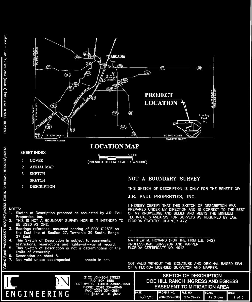
1 Appendix H: Sketch & Legal Description of Mitigation Bank and Ingress/Egress Access Easements Tippen Bay Wetland Mitigation Bank DeSoto County, Florida Prepared by: September, 2017
2
3

4
5
6
7
8
9
10
11 Original file name: Approved Permanent Access Easement.pdf PERMANENT ACCESS EASEMENT Return original or certified recorded document to: Southwest Florida Water Management District Office of General Counsel 7601 U.S. Hwy. 301 Tampa, FL THIS PERMANENT ACCESS EASEMENT ( Easement ) is given this day of, 2016, by J.R. Paul Properties, Inc. ( Grantor ), whose mailing address is 5701 Ft. Denaud Road, Labelle, Florida 33935, to the Southwest Florida Water Management District ( Grantee ), a public corporation, having an address of 2379 Broad Street, Brooksville, Florida As used herein, the term Grantor shall include any and all heirs, successors or assigns of the Grantor, and all subsequent owners of the Property (as hereinafter defined) and the term Grantee shall include any successor or assignee of Grantee. WITNESSETH WHEREAS, Grantor is the fee simple owner of certain lands situated in DeSoto County, Florida, and more specifically described in Exhibit "A" attached hereto and incorporated herein (the "Property"); and WHEREAS, Grantor has conveyed to Grantee a conservation easement on the property described in Exhibit B attached hereto and incorporated herein (the Conservation Easement Property ); and WHEREAS, Grantor has agreed to grant and convey to Grantee, a permanent nonexclusive access easement over, on, upon, and across the Property for access to the Conservation Easement Property from Farabee Road, as set forth herein. NOW, THEREFORE, in consideration of the mutual covenants, promises, terms and conditions set forth herein, together with other good and valuable consideration provided to Grantor, the adequacy and receipt of which are hereby acknowledged, Grantor hereby voluntarily grants, creates, conveys, and establishes a perpetual easement for and in favor of Grantee upon the Property described on Exhibit A which shall run with the land and be binding upon the Grantor. The scope, nature, and character of this Easement shall be as follows: Page 1 of 11
12 1. Recitals. The recitals herein are true and correct and are hereby incorporated into and made a part of this Easement. 2. Purpose. It is the purpose of this Easement to grant a permanent non-exclusive access easement over, on, upon, and across the Property for the purpose of vehicular and pedestrian ingress and egress to and from the Conservation Easement Property. 3. No Dedication. No right of access by the general public to any portion of the Property is created or conveyed by this Easement. 4. Grantee's Liability. Grantee s liability is limited as provided in Subsection (10) and Section , F.S. 5. Duration. This Easement shall remain in full force and effect in perpetuity. 6. Modification. This Easement may be amended, altered, released or revoked only by written agreement between the parties hereto or their heirs, assigns or successors-in-interest, which shall be filed in the public records in DeSoto County, Florida. 7. Improvement and Maintenance of Easement. Neither Grantor nor Grantee shall have any obligation or duty to improve, maintain, repair or pay any cost to improve, maintain, or repair the Easement on the Property described on Exhibit A, and neither Grantor nor Grantee warrants to the other that the Easement is or will remain suitable for the use of motor vehicles, all-terrain vehicles, or other motorized modes of travel without improvement, repair, or maintenance. Grantee accepts the Easement in its as is condition. 8. Use of Easement Property. Grantor may use the Easement for any purpose that does not unreasonably interfere with the uses granted herein to Grantee. Grantee shall not unreasonably interfere with Grantor s use of the Easement Property. Grantee s use of the Easement shall be at the sole risk and expense of the Grantee. 9. Fences and Gates. Grantor may fence all or a portion of the Property and place one or more gates on the Property. If a gate is installed by Grantor and Grantee uses the gate, Grantee shall close and secure the gate immediately after its use. Grantee shall not damage any fence or gate that is installed by Grantor and shall pay Grantor the cost to repair any fencing or gate that is damaged by Grantee or any of Grantee s agents, guests, licensees, or invitees. Grantor may install a lock on any gate on the Property, and if a lock is installed by Grantor, Grantor shall provide Grantee a key or combination to the lock. If immediately before a gate is opened by Grantee the gate is locked, Grantee shall immediately lock the gate after its use by Grantee. Grantee shall not install a lock on any gate on the Property unless Grantee provides Grantor a key or the combination to the lock. 10. Construction Liens. Grantor s title to and ownership of the Property is not subject to liens for improvements made by Grantee to or upon the Property, and such liability is expressly prohibited as contemplated by Section , Florida Statutes. Grantee shall not permit any lien to be placed against or upon the Property. Page 2 of 11
13 11. Governing Law. This Easement shall be interpreted, construed, governed by, and enforced in accordance with the laws of the State of Florida. All claims, disputes and other matters in question arising out of or relating to this Easement or the breach hereof, shall be decided by proceedings initiated and litigated in the state or federal courts located in or serving DeSoto County, Florida, and the parties expressly consent to the venue and jurisdiction of such courts. 13. Attorneys Fees and Costs. The prevailing party in any litigation brought to interpret or enforce this Easement or for damages for the violation of any duty created by this Easement shall be entitled to recover its reasonable attorney fees and costs from the non-prevailing party. 14. Entire Agreement. This Easement contains the entire understanding of the parties as it relates to Grantee s ingress to and egress from the property described in Exhibit B. Any prior or inconsistent agreement concerning the use of the Property is superseded by this Easement. IN WITNESS WHEREOF, J.R. PAUL PROPERTIES, INC., ( Grantor ) has hereunto set its authorized hand this day of, 20. A Florida corporation, By: Name: Title: (Print) (Signature) Signed, sealed and delivered in our presence as witnesses: By: By: (Signature) Name: Name: (Print) STATE OF FLORIDA COUNTY OF On this, 20, before me, the undersigned notary public, personally appeared, the person who subscribed to the foregoing instrument, as the (title), of J.R. Paul Properties, Inc., a Florida corporation and acknowledged that he executed the same on Page 3 of 11
14 behalf of said corporation, and the he was duly authorized to do so. He is personally known to me or has produced a (state) driver s license as identification. IN WITNESS WHEREOF, I hereunto set my hand and official seal. NOTARY PUBLIC, STATE OF FLORIDA (Signature) (Name) My Commission Expires: Page 4 of 11
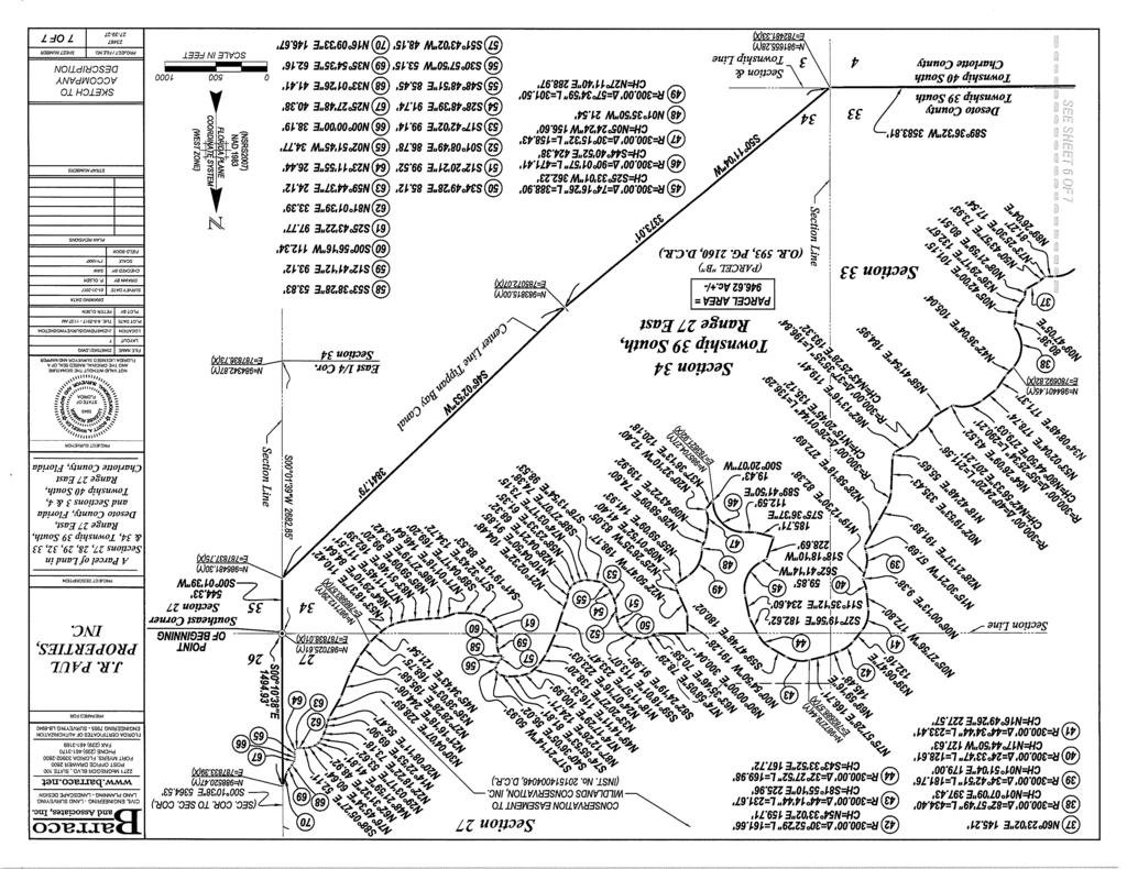
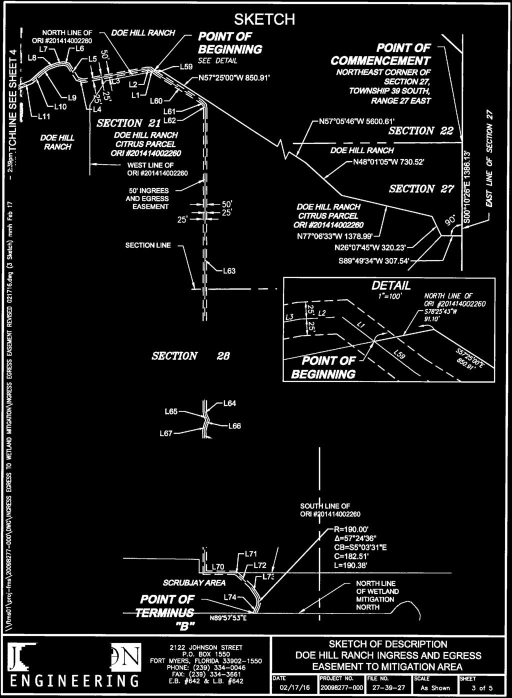
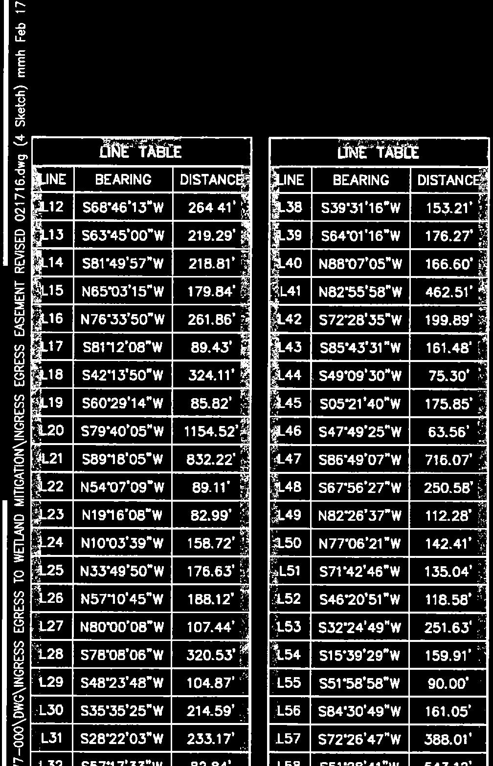
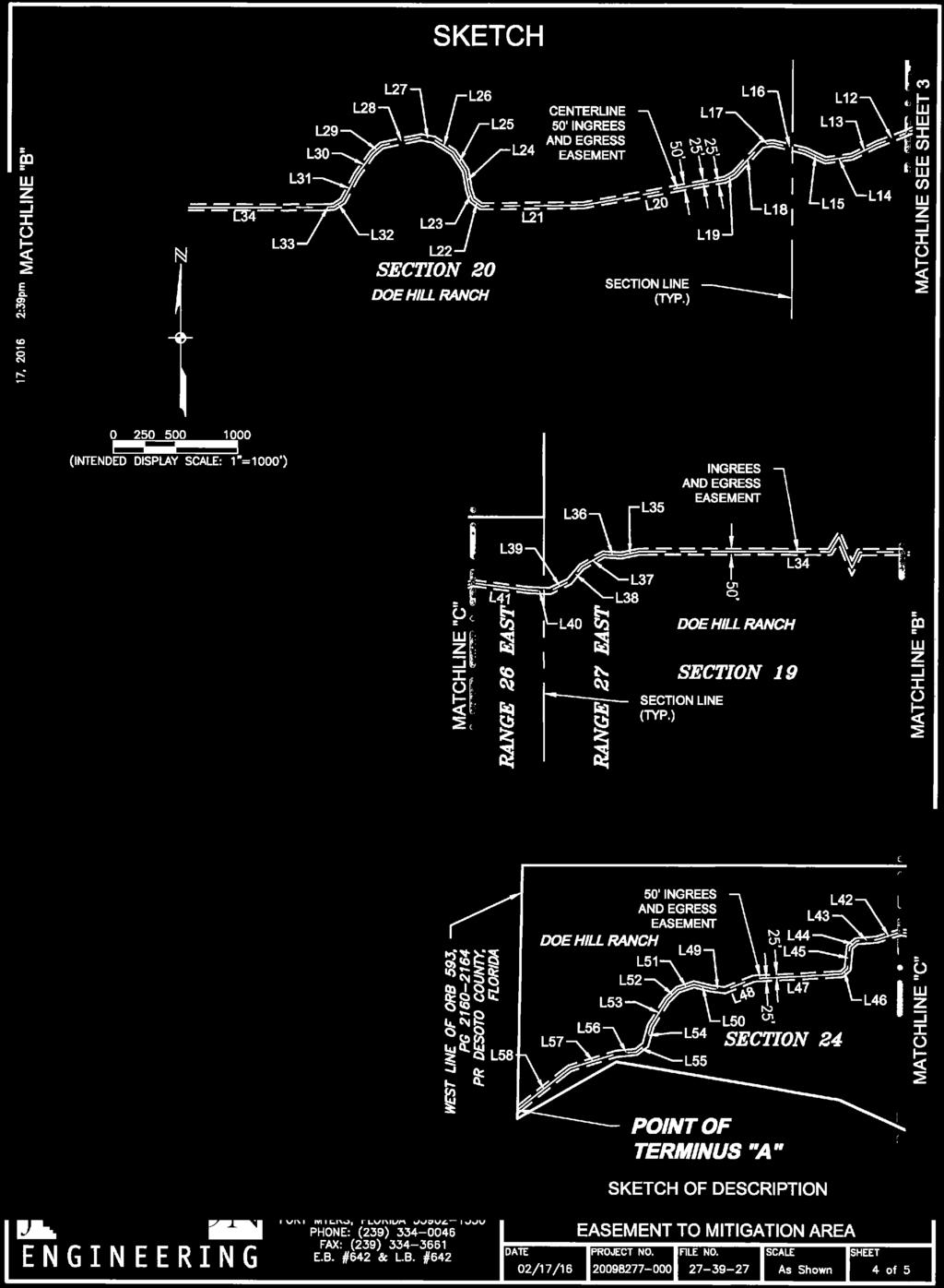
15 Exhibit A AN EASEMENT FOR INGRESS AND EGRESS LYING IN SECTION 24, TOWNSHIP 39 SOUTH, RANGE 26 EAST AND SECTIONS 19, 20, 21 AND 28, TOWNSHIP 39 SOUTH, RANGE 27 EAST, DESOTO COUNTY, FLORIDA, LYING 25 FEET ON EACH SIDE OF THE FOLLOWING DESCRIBED CENTERLINE: COMMENCE AT THE NORTHEAST CORNER OF SAID SECTION 27 AND RUN S00 10'26"E, ALONG THE EAST LINE OF SAID SECTION 27, A DISTANCE OF 1, FEET; THENCE S89 49'34"W, ALONG A LINE PERPENDICULAR TO THE EAST LINE OF SAID SECTION 27, A DISTANCE OF FEET; THENCE N26 07'45"W A DISTANCE OF FEET; THENCE N77 06'33"W A DISTANCE OF 1, FEET; THENCE N48 01'05"W A DISTANCE OF FEET; THENCE N57 05'46"W A DISTANCE OF 5, FEET; THENCE N57 25'00"W A DISTANCE OF FEET; THENCE S78 25'43"W A DISTANCE OF FEET TO THE POINT OF BEGINNING, BEING A POINT ON THE NORTH LINE OF LANDS DESCRIBED IN OFFICIAL RECORDS INSTRUMENT , OF THE PUBLIC RECORDS OF DESOTO COUNTY, FLORIDA; THENCE N52 55'59"W A DISTANCE OF FEET; THENCE S86 51'11"W A DISTANCE OF FEET; THENCE S79 17'00"W A DISTANCE OF FEET; THENCE N74 10'23"W A DISTANCE OF FEET; THENCE N33 38'26"W A DISTANCE OF FEET; THENCE N74 45'36"W A DISTANCE OF FEET; THENCE S79 23'28"W A DISTANCE OF FEET; THENCE S69 27'51"W A DISTANCE OF FEET; THENCE S53 09'35"W A DISTANCE OF FEET; THENCE S47 25'39"W A DISTANCE OF FEET; THENCE S67 07'02"W A DISTANCE OF FEET; THENCE S68 46'13"W A DISTANCE OF FEET; THENCE S63 45'00"W A DISTANCE OF FEET; THENCE S81 49'57"W A DISTANCE OF FEET; THENCE N65 03'15"W A DISTANCE OF FEET; THENCE N76 33'50"W A DISTANCE OF FEET; THENCE S81 12'08"W A DISTANCE OF FEET; THENCE S42 13'50"W A DISTANCE OF FEET; THENCE S60 29'14"W A DISTANCE OF FEET; THENCE S79 40'05"W A DISTANCE OF 1, FEET; THENCE S89 18'05"W A DISTANCE OF FEET; THENCE N54 07'09"W A DISTANCE OF FEET; THENCE N19 16'08"W A DISTANCE OF FEET; THENCE N10 03'39"W A DISTANCE OF FEET; THENCE N33 49'50"W A DISTANCE OF FEET; THENCE N57 10'45"W A DISTANCE OF FEET; THENCE N80 00'08"W A DISTANCE OF FEET; THENCE S78 08'06"W A DISTANCE OF FEET; THENCE S48 23'48"W A DISTANCE OF FEET; THENCE S35 35'25"W A DISTANCE OF FEET; THENCE S28 22'03"W A DISTANCE OF FEET; THENCE S57 17'33"W A DISTANCE OF FEET; THENCE S86 22'57"W A DISTANCE OF FEET; THENCE S89 52'30"W A DISTANCE OF 6, FEET; THENCE S77 51'31"W A DISTANCE OF FEET; THENCE N86 23'59"W A DISTANCE OF FEET; THENCE S59 58'20"W A DISTANCE OF FEET; THENCE S39 31'16"W A DISTANCE OF FEET; THENCE S64 01'16"W A DISTANCE OF FEET; THENCE N88 07'05"W A DISTANCE OF FEET; THENCE N82 55'58"W A DISTANCE OF FEET; THENCE S72 28'35"W A DISTANCE OF FEET; THENCE S85 43'31"W A DISTANCE OF FEET; THENCE S49 09'30"W A DISTANCE OF FEET; THENCE S05 21'40"W A DISTANCE OF FEET; THENCE S47 49'25"W A DISTANCE OF FEET; THENCE S86 49'07"W A DISTANCE OF FEET; THENCE Page 5 of 11
16 S67 56'27"W A DISTANCE OF FEET; THENCE N82 26'37"W A DISTANCE OF FEET; THENCE N77 06'21"W A DISTANCE OF FEET; THENCE S71 42'46"W A DISTANCE OF FEET; THENCE S46 20'51"W A DISTANCE OF FEET; THENCE S32 24'49"W A DISTANCE OF FEET; THENCE S15 39'29"W A DISTANCE OF FEET; THENCE S51 58'58"W A DISTANCE OF FEET; THENCE S84 30'49"W A DISTANCE OF FEET; THENCE S72 26'47"W A DISTANCE OF FEET; THENCE S51 28'41"W A DISTANCE OF FEET TO POINT OF TERMINUS "A", BEING ON THE WEST LINE OF OFFICIAL RECORDS BOOK 593, PAGE , OF THE PUBLIC RECORDS OF DESOTO COUNTY, FLORIDA. AND, RETURNING TO THE AFOREMENTIONED POINT OF BEGINNING, THENCE S52 55'59"E, A DISTANCE OF FEET; THENCE S58 09'15"E, A DISTANCE OF FEET; THENCE S46 18'28"E, A DISTANCE OF FEET; THENCE S07 54'10"E, A DISTANCE OF FEET; THENCE S00 07'28"E, A DISTANCE OF 4, FEET; THENCE S07 27'52"E, A DISTANCE OF FEET; THENCE S24 46'01"E, A DISTANCE OF FEET; THENCE S22 09'27"W, A DISTANCE OF FEET; THENCE S14 03'41"W, A DISTANCE OF FEET; THENCE S03 33'03"E, A DISTANCE OF FEET; THENCE S00 10'34"E, A DISTANCE OF 1, FEET; THENCE N89 55'23"E, A DISTANCE OF FEET; THENCE S59 09'29"E, A DISTANCE OF FEET; THENCE S48 08'44"E, A DISTANCE OF FEET; THENCE S33 45'49"E, A DISTANCE OF FEET; THENCE SOUTHERLY ON THE ARC OF A CURVE TO THE RIGHT HAVING: A RADIUS OF FEET, A DELTA ANGLE OF 57 24'36", A CHORD BEARING OF S05 03'31"E, AND A CHORD DISTANCE OF FEET, FOR AN ARC DISTANCE OF FEET; THENCE S23 38'47"W, A DISTANCE OF FEET TO POINT OF TERMINUS "B", BEING ON THE NORTH LINE OF WETLAND MITIGATION NORTH. THE SIDE LINES OF SAID EASEMENT TO BE LENGTHENED OR SHORTENED TO MEET THE WEST LINE OF SAID OFFICIAL RECORDS BOOK 593, PAGE AND THE NORTH LINE OF WETLAND MITIGATION NORTH, BEING A LINE PASSING THROUGH POINT OF TERMINUS "B" BEARING NORTH 89 57'53" EAST. BEARINGS ARE BASED ON THE EAST LINE OF SECTION 27, TOWNSHIP 39 SOUTH, RANGE 27 EAST, BEING S00 10'26"E. DESCRIPTION IS SUBJECT TO EASEMENTS, RESTRICTIONS, RESERVATIONS AND RIGHTS-OF-WAY OF RECORD. Page 6 of 11


17 Page 7 of 11


18 Page 8 of 11


19 Page 9 of 11


20 Page 10 of 11

21 Page 11 of 11
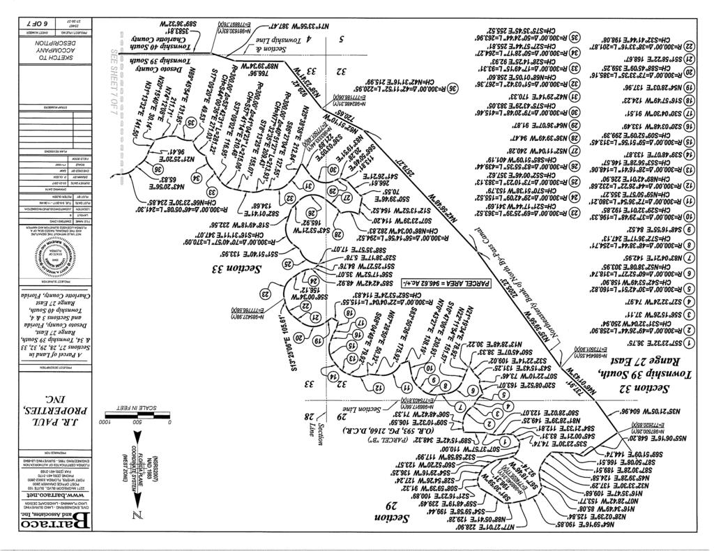
22 SHEET NUMBER CIVIL ENGINEERING - LAND SURVEYING LAND PLANNING - LANDSCAPE DESIGN 2271 McGREGOR BLVD., SUITE 100 POST OFFICE DRAWER 2800 FORT MYERS, FLORIDA PHONE (239) FAX (239) FLORIDA CERTIFICATES OF AUTHORIZATION ENGINEERING SURVEYING LB-6940 BRYAN PREPARED FOR PAUL CITRUS, INC. P.O. BOX 2357 LABELLE, FL PHONE (863) PROJECT DESCRIPTION A Parcel of Land in Sections 28 & 33, Township 39 South, Range 27 East, Desoto County, Florida NOTES: 1. ALL DISTANCES SHOWN ARE IN FEET AND DECIMALS THEREOF. UNLESS OTHERWISE NOTED DISTANCES ARE ALSO (U.S. SURVEY FEET) GROUND AND CAN BE MULTIPLIED BY TO OBTAIN GRID DISTANCES. 2 INST. No.- DENOTES INSTRUMENT NUMBER, DESOTO COUNTY PUBLIC RECORDS. 3. O.R. - DENOTES OFFICIAL RECORD BOOK, DESOTO COUNTY PUBLIC RECORDS. 4. PG. - DENOTES PAGE. 5. BEARINGS AND COORDINATE SHOWN ARE STATE PLANE FLORIDA WEST ZONE (NAD1983 (NSRS 2007)) ARE BASED ON THE EAST LINE SECTION 27 TO BEAR N00 10'38"W. 6. DESCRIPTION IS ATTACHED. N SCALE IN FEET THIS IS NOT A SURVEY PROJECT SURVEYOR 5949 STATE OF FLORIDA NOT VALID WITHOUT THE SIGNATURE AND THE ORIGINAL RAISED SEAL OF A FLORIDA LICENSED SURVEYOR AND MAPPER FILE NAME 23467SK02.DWG LAYOUT 2 LOCATION J:\23467\DWG\SURVEYING\SKETCH\ PLOT DATE TUE :47 AM PLOT BY PETER OLSEN DRAWING DATA SURVEY DATE DRAWN BY P. OLSEN CHECKED BY SCALE 1"=300' FIELD BOOK PLAN REVISIONS STRAP NUMBERS (ACCESS EXTENSION) SCOTT A. WHEELER (FOR THE FIRM - LB-6940) PROFESSIONAL SURVEYOR AND MAPPER FLORIDA CERTIFICATE NO DATE SIGNED: NOT VALID WITHOUT THE SIGNATURE AND THE ORIGINAL RAISED SEAL OF A FLORIDA LICENSED SURVEYOR AND MAPPER. SKETCH TO ACCOMPANY DESCRIPTION PROJECT / FILE NO OF 2
23 DESCRIPTION Parcel in Sections 28 & 33, Township 39 South, Range 27 East, Desoto County, Florida A tract or parcel of land lying in Sections 28 & 33, Township 39 South, Range 27 East, Desoto County, Florida, said tract or parcel of land being more particularly described as follows: COMMENCING at the Southeast corner of Section 27, Township 39 South, Range 27 East, run N00 10'38"W along the East line of said Section 27 for feet to an intersection with Easterly prolongation of the Southerly line of a Conservation Easement described in a deed recorded in Instrument No , Desoto County Records; thence run S89 57'53"W along said Easterly prolongation and continuing along said Southerly line for 6, feet to the POINT OF BEGINNING. From said Point of Beginning run S23 38'47"W for feet to a point of curvature; thence run Southerly along an arc of a curve to the left of radius feet (delta 75 38'47") (chord bearing S14 10'37"E) (chord feet) for feet to a point of tangency; thence run S52 00'00"E for feet to a point of curvature; thence run Southeasterly along an arc of a curve to the right of radius feet (delta 33 00'00") (chord bearing S35 30'00"E) (chord feet) for feet to a point of tangency; thence run S19 00'00"E for feet to an intersection with the Westerly line of a proposed conservation easement; thence run along said Westerly line of the following two (2) courses: S76 38'11"W for feet and S28 58'18"W for feet; thence run N19 00'00"W for feet to a point of curvature; thence run Northwesterly along an arc of a curve to the left of radius feet (delta 33 00'00") (chord bearing N35 30'00"W) (chord feet) for feet to a point of tangency; thence run N52 00'00"W for feet to a point of curvature; thence run Northerly along an arc of a curve to the right of radius feet (delta 75 38'47") (chord bearing N14 10'37"W) (chord feet) for feet to a point of tangency; thence run N23 38'47"E for feet to an intersection with the Southerly line of said Conservation Easement described in a deed recorded in Instrument No , Desoto County Records; thence run N89 57'53"E along said Southerly line for feet to the POINT OF BEGINNING. Containing 2.22 acres, more or less. Bearings hereinabove mentioned are State Plane for the Florida West Zone (1983/NSRS 2007) and are based on the East line of said Section 27 to bear N00 10'38"W. L:\ Tippan Bay\Survey\Descriptions\23467sk02.doc Scott A. Wheeler (For The Firm) Professional Surveyor and Mapper Florida Certificate No Post Office Drawer 2800 Fort Myers, FL Phone (239) Fax (239)
24 DESCRIPTION (CONTINUED) Page 2
WATERFORD LANDING COMMUNITY DEVELOPMENT DISTRICT REGULAR MEETING AGENDA
 WATERFORD LANDING COMMUNITY DEVELOPMENT DISTRICT REGULAR MEETING AGENDA January 31, 2019 Waterford Landing Community Development District OFFICE OF THE DISTRICT MANAGER 2300 Glades Road, Suite 410W Boca
CONSENT ACTION BY THE BOARD OF DIRECTORS OF VENETO IN MIRAMAR CONDOMINIUM ASSOCIATION, INC.
 CONSENT ACTION BY THE BOARD OF DIRECTORS OF VENETO IN MIRAMAR CONDOMINIUM ASSOCIATION, INC. The undersigned, being all of the members of the Board of Directors of Veneto in Miramar Condominium Association,
EASEMENT AGREEMENT. WHEREAS, Hall Brothers owns certain real property located in Weber County, Utah ( Hall Brothers Property );
;") When Recorded Return to: Parcel No. EASEMENT AGREEMENT THIS EASEMENT AGREEMENT ( Agreement ) is entered into this day of, 2016 by and between VALLEY DREAMS PROPERTIES, LLC, a Utah limited liability company
When Recorded Return to: Parcel No. EASEMENT AGREEMENT THIS EASEMENT AGREEMENT ( Agreement ) is entered into this day of, 2016 by and between VALLEY DREAMS PROPERTIES, LLC, a Utah limited liability company
AMENDED DEED OF CONSERVATION EASEMENT
 Prepared by: Wayne E. Flowers Lewis, Longman & Walker, P.A. 245 Riverside Ave. Suite 150 Jacksonville, FL 32202 Return recorded original to: Mitigation Marketing 1091 W. Morse Blvd. Suite 101 Winter Park,
RIGHT OF WAY AND COMMON DRIVEWAY AGREEMENT SUN8 PDC, LLC, c/o DISTRIBUTED SUN, LLC SUBDIVISION DRYDEN, NEW YORK
 RIGHT OF WAY AND COMMON DRIVEWAY AGREEMENT SUN8 PDC, LLC, c/o DISTRIBUTED SUN, LLC SUBDIVISION DRYDEN, NEW YORK THIS RIGHT OF WAY AGREEMENT ( Agreement ) is made this day of, 2017 by SCOTT PINNEY, an individual
WATER LINE & INGRESS/EGRESS EASEMENT AGREEMENT WITNESSETH:
 Prepared by and return to: Carie E. Shealy, MMC, City Clerk City of Cocoa 65 Stone Street Cocoa, Florida 32922 Parcel ID. #(s): WATER LINE & INGRESS/EGRESS EASEMENT AGREEMENT THIS EASEMENT AGREEMENT is
BILL NO (Emergency Measure) ORDINANCE NO. 5072
 ORDINANCE NO. 5072") BILL NO. 5210 (Emergency Measure) ORDINANCE NO. 5072 AN ORDINANCE AUTHORIZING THE MAYOR TO EXECUTE WITH MICHELSON-HADLEY HEIGHTS DEVELOPMENT, LLC, A CONTRACT AND QUIT CLAIM DEED CONVEYING CERTAIN PROPERTIES
BILL NO. 5210 (Emergency Measure) ORDINANCE NO. 5072 AN ORDINANCE AUTHORIZING THE MAYOR TO EXECUTE WITH MICHELSON-HADLEY HEIGHTS DEVELOPMENT, LLC, A CONTRACT AND QUIT CLAIM DEED CONVEYING CERTAIN PROPERTIES
BILL OF SALE. All of the water lines, writer mains anrl appurtenances locaterl on Exhibit "A"
 BILL OF SALE KNOW ALL MEN BY THESE PRESENTS, That on this-day of,2008, that School Board of Brevard County a Florida Corporation, hereinafter called "Sellers", and in consideration of the sum of One Dollar
LANDSCAPE AND MAINTENANCE EASEMENT. THIS LANDSCAPE AND MAINTENANCE EASEMENT, (hereinafter Easement )
") Prepared by and return to: Parcel ID # LANDSCAPE AND MAINTENANCE EASEMENT THIS LANDSCAPE AND MAINTENANCE EASEMENT, (hereinafter Easement ) is made and entered into this day of, 2009, by and between THIRD
Prepared by and return to: Parcel ID # LANDSCAPE AND MAINTENANCE EASEMENT THIS LANDSCAPE AND MAINTENANCE EASEMENT, (hereinafter Easement ) is made and entered into this day of, 2009, by and between THIRD
DECLARATION OF EASEMENTS AND COST SHARING AGREEMENT
 PREPARED BY AND AFTER RECORDING RETURN TO: James Johnston, Esq. Shutts & Bowen LLP 300 S. Orange Avenue Suite 1000 Orlando, Florida 32801 Tax Parcel I.D.s: 25-21-29-0000-00-032 25-21-29-4432-00-001 DECLARATION
COUNCIL ACTION FORM Meeting Date: September 13, 2012 Staff Contact: John Sullivan, Public Works Director
 COUNCIL ACTION FORM Meeting Date: September 13, 2012 Staff Contact: John Sullivan, Public Works Director Agenda Item: Consider vacation of a Landscape Easement granted to the City of Westwood for the construction
DEED AND DEDICATION FOR PUBLIC RIGHT OF WAY
 TO : BOARD OF DIRECTORS FROM : GARY PLATT, EXEC. DIRECTOR BUSINESS AND OPERATIONS SUBJECT : CITY OF STANWOOD CONSTRUCTION EASEMENT AND RIGHT-OF-WAY DEDICATION DATE : MARCH 17, 2009 TYPE : ACTION NEEDED
ORDINANCE NO AN ORDINANCE To Be Entitled:
 3808 AN ORDINANCE To Be Entitled: AN ORDINANCE OF THE CITY COUNCIL OF THE CITY OF FORT MYERS, FLORIDA, REZONING FROM COMMERCIAL GENERAL TO PLANNED UNIT DEVELOPMENT AND APPROVING THE DEVELOPMENT PLAN FOR
AMENDMENT TO POWER PURCHASE AGREEMENT
 AMENDMENT TO POWER PURCHASE AGREEMENT This Amendment Power Purchase and Agreement ( Amendment ) is entered into as of, 2012, by and between, (hereinafter RMW ) a Nevada limited liability company, and The
PERMANENT EASEMENT AGREEMENT
 PERMANENT EASEMENT AGREEMENT THIS PERMANENT EASEMENT AGREEMENT ( Agreement ) is made and entered into this day of, 2016 ( Effective Date ), by and between Staker & Parson Companies, a Utah corporation
MEMORANDUM. Mayor and City Council. Warren Hutmacher, City Manager. Date: February 11, 2013
 MEMORANDUM To: From: Mayor and City Council Warren Hutmacher, City Manager Date: February 11, 2013 Subject: Approval of an Intergovernmental agreement by and between the City of Dunwoody and DeKalb County
NON-EXCLUSIVE EASEMENT AGREEMENT
 Prepared by: Catherine D. Reischmann, Esq. 111 N. Orange Ave., Ste. 2000 Orlando, FL 32801 Return to: City Clerk City of Palm Coast 160 Cypress Point Parkway, Ste. B-106 Palm Coast, FL 32164 NON-EXCLUSIVE
ATTACHMENT Q DRAFT COMMON DRIVEWAY AGREEMENT
 ATTACHMENT Q DRAFT COMMON DRIVEWAY AGREEMENT RIGHT OF WAY AND COMMON DRIVEWAY AGREEMENT [Delaware River Solar LLC & NY Dryden I LLC] SUBDIVISION DRYDEN, NEW YORK THIS RIGHT OF WAY AGREEMENT ( Agreement
AGREEMENT RECITALS: Draft 3/26/2015
 AGREEMENT This Agreement is entered into this day of April, 2015, by and between the SCHOOL BOARD OF BREVARD COUNTY, FLORIDA (the "School Board") and THE CITY OF MELBOURNE, a Florida municipal corporation
EASEMENT DEED. 2) Thence N 60º12 36 W through said Parcel 1 a distance of Two Hundred Ninety- Five and 97/100 (295.97) feet to a point;
 Thence N 60º12 36 W through said Parcel 1 a distance of Two Hundred Ninety- Five and 97/100 (295.97) feet to a point;") EASEMENT DEED TALL TREES CONSTRUCTION CORP., a Maine corporation having a mailing address of 30 Preservation Drive, Falmouth, Maine 04105 (the "Grantor") for consideration paid, grants to the TOWN OF FALMOUTH,
EASEMENT DEED TALL TREES CONSTRUCTION CORP., a Maine corporation having a mailing address of 30 Preservation Drive, Falmouth, Maine 04105 (the "Grantor") for consideration paid, grants to the TOWN OF FALMOUTH,
DRAINAGE AND UTILITY EASEMENT. That Bruce Conrad, a single adult, hereinafter referred to as Grantor for good and
 DRAINAGE AND UTILITY EASEMENT KNOW ALL PERSONS BY THESE PRESENTS: That Bruce Conrad, a single adult, hereinafter referred to as Grantor for good and valuable consideration, the receipt and sufficiency
WATER CONSERVATION EASEMENT
 WHEN RECORDED RETURN TO: Washington County Water Conservancy District 533 East Waterworks Dr. St. George, Utah 84770 Space Above This Line for Recorder s Use Serial No. WATER CONSERVATION EASEMENT THIS
DECLARATION OF UNITY OF CONTROL
 PREPARED BY AND RETURN TO: Scott Backman, Esq. Dunay, Miske! and Backman, LLP 14 SE 4th Street, Suite 36 Boca Raton, FL 33432 DECLARATION OF UNITY OF CONTROL THIS DECLARATION of Unity of Control ("Declaration")
COUNCIL AGENDA MEMO ITEM NO. III - #1
 COUNCIL AGENDA MEMO ITEM NO. III - #1 FROM: Anton Jelinek, Director of Utilities MEETING: October 24, 2017 SUBJECT: PRESENTER: Permanent Utility and Right-of-Way Easement Anton Jelinek Discussion: At the
EXHIBIT 2 Page 1 of 6
 Page 1 of 6 Return to: Broward County Real Property Section 115 South Andrews Avenue, Room 501 Fort Lauderdale, FL 33301 Prepared by: Richard Weber 11240 NW 27 1 h CT Plantation, Florida 33323 Folio Number:
PIPELINE RIGHT-OF-WAY EASEMENT
 PIPELINE RIGHT-OF-WAY EASEMENT THIS RIGHT-OF-WAY EASEMENT made this day of March, 2014, by the City of Rochester Hills, a municipal corporation in the State of Michigan,, having an address at 1000 Rochester
FIFTH AMENDMENT OF DECLARATION OF DEED RESTRICTIONS AND DEDICATIONS FOR PINEHURST ESTATES (A Clatsop County, Oregon Subdivision)
") After Recording Return To: W. Louis Larson 990 Astor Street Astoria, OR 97103 FIFTH AMENDMENT OF DECLARATION OF DEED RESTRICTIONS AND DEDICATIONS FOR PINEHURST ESTATES (A Clatsop County, Oregon Subdivision)
After Recording Return To: W. Louis Larson 990 Astor Street Astoria, OR 97103 FIFTH AMENDMENT OF DECLARATION OF DEED RESTRICTIONS AND DEDICATIONS FOR PINEHURST ESTATES (A Clatsop County, Oregon Subdivision)
CORPORATE SPECIAL WARRANTY DEED FOR RIGHT OF WAY
 CORPORATE SPECIAL WARRANTY DEED FOR RIGHT OF WAY THIS INDENTURE WITNESSETH that ELI LILLY AND COMPANY, an Indiana corporation, ( Grantor ), as a gift and for no other consideration, CONVEYS ANDSPECIALLY
CONTRACT FOR SALE AND PURCHASE
 CONTRACT FOR SALE AND PURCHASE THIS CONTRACT FOR SALE AND PURCHASE ("Agreement") is entered into on this day of, 20, by and between BROWARD COUNTY, a political subdivision of the State of Florida ("COUNTY''
DISTRICT. Huntington Beach. FIM 40-40C-3 APN and
 RECORDING REQUESTED BY W HEN RECORDED MAIL TO SOUTHERN CALIFORNIA EDISON COMPANY 2131 WALNUT GROVE AVENUE 2 ND FLOOR GO3 ROSEMEAD, CA 91770 Attn: Title and Real Estate Services SPACE ABOVE THIS LINE FOR
EASEMENT AGREEMENT. WHEREAS, Ferguson is the 100% owner of the property described on Exhibit B attached hereto (the Williams Property );
;") EASEMENT AGREEMENT THIS EASEMENT AGREEMENT ( Agreement ) is entered into as of this day of, 2016, by and between CRAIG FERGUSON ( Ferguson ), and MAMIE DAVIS and JERRY MOORE ( Davis & Moore ), whose legal
EASEMENT AGREEMENT THIS EASEMENT AGREEMENT ( Agreement ) is entered into as of this day of, 2016, by and between CRAIG FERGUSON ( Ferguson ), and MAMIE DAVIS and JERRY MOORE ( Davis & Moore ), whose legal
Isles of Bartram Community Development District 475 West Town Place, Suite 114, St. Augustine, Florida Phone: Fax:
 ISLES OF BARTRAM PARI( Community Development District October 18, 2017 Isles of Bartram Community Development District 475 West Town Place, Suite 114, St. Augustine, Florida 32092 Phone: 904-940-5850 -
Environmental and Engineering Services EASEMENT INFORMATION AND EXAMPLE DOCUMENTS
 Environmental and Engineering Services Reddy Chitepu, P.E., Director EASEMENT INFORMATION AND EXAMPLE DOCUMENTS Please refer to the information below when compiling easement documents for submittal to
DECLARATION OF RESTRICTIVE COVENANT
 This instrument prepared by: D. Scott Knight Hillsborough County Aviation Authority PO Box 22287 Tampa, FL 33622 DECLARATION OF RESTRICTIVE COVENANT THIS DECLARATION OF RESTRICTIVE COVENANT (hereinafter
MEETING TYPE: Board of Commissioners - Regular. MEETING DATE: 23 May STAFF RESPONSIBLE: Matt Hubert. DEPARTMENT: Development Services Department
 MEETING TYPE: Board of Commissioners - Regular MEETING DATE: 23 May 2017 STAFF RESPONSIBLE: Matt Hubert DEPARTMENT: Development Services Department DESCRIPTION Approval of Easement Agreement To approve
ENCROACHMENT AGREEMENT
 THIS INSTRUMENT PREPARED BY: Roy K. Payne, Esq. Chief Assistant City Attorney City of Orlando 400 S. Orange Avenue Orlando, Florida 32801 (407) 246-3495 ENCROACHMENT AGREEMENT THIS ENCROACHMENT AGREEMENT,
GREENWAY EASEMENT AGREEMENT
 GREENWAY EASEMENT AGREEMENT This greenway access easement is entered into by and between the Laramie County School District Number One ( Grantor ), a corporate body organized under the laws of the State
[SPACE ABOVE THIS LINE FOR RECORDING INFORMATION]
![[SPACE ABOVE THIS LINE FOR RECORDING INFORMATION]](/thumbs/74/69889180.jpg "[SPACE ABOVE THIS LINE FOR RECORDING INFORMATION]") INSTRUMENT#: 2010398579, BK: 20216 PG: 1321 PGS: 1321-1326 11/23/2010 at 04:03:44 PM, DEPUTY CLERK:LPERTUIS Pat Frank,Clerk of the Circuit Court Hillsborough County ~l=~ntff~e' ~ F ~ E [] (~ 0 ~)) Y Donald
INSTRUMENT#: 2010398579, BK: 20216 PG: 1321 PGS: 1321-1326 11/23/2010 at 04:03:44 PM, DEPUTY CLERK:LPERTUIS Pat Frank,Clerk of the Circuit Court Hillsborough County ~l=~ntff~e' ~ F ~ E [] (~ 0 ~)) Y Donald
Cross Reference: Instrument No. A State Parcel No Parcel: TEMPORARY CONSTRUCTION EASEMENT AGREEMENT
 Cross Reference: Instrument No. A199500066899 Project: 92TU000128 State Parcel No. 49-07-18-107-004.000-801 Parcel: 8033304 Date: Version: TEMPORARY CONSTRUCTION EASEMENT AGREEMENT THIS TEMPORARY CONSTRUCTION
CITY OF INDIANAPOLIS GRANT OF PERPETUAL DRAINAGE EASEMENT AND RIGHT-OF-WAY
 CROSS REFERENCE TO DEED#: PROJECT #: DRN - INSTRUMENT NO.: PARCEL #: CITY OF INDIANAPOLIS GRANT OF PERPETUAL DRAINAGE EASEMENT AND RIGHT-OF-WAY THIS INDENTURE made this day of, 20, by and between, ("GRANTOR")
DECLARATION OF DRAINAGE EASEMENTS. Document No. Document Title. (Declarant) Recording Data Return Address
 Recording Data Return Address") Document No. DECLARATION OF DRAINAGE EASEMENTS Document Title (Declarant) Recording Data Return Address DOCUMENT PREPARED BY AND AFTER RECORDING RETURN TO: Parcel No. - - - - - - DECLARATION OF DRAINAGE
Document No. DECLARATION OF DRAINAGE EASEMENTS Document Title (Declarant) Recording Data Return Address DOCUMENT PREPARED BY AND AFTER RECORDING RETURN TO: Parcel No. - - - - - - DECLARATION OF DRAINAGE
RESOLUTION NO
 Page 1 of 9 1 2 3 4 5 6 RESOLUTION NO. 2018- A RESOLUTION OF THE BOARD OF COUNTY COMMISSIONERS OF BROWARD COUNTY, FLORIDA, ACCEPTING AN EASEMENT ON, OVER, UNDER, ACROSS, AND THROUGH A PORTION OF REAL PROPERTY
UTILITY EASEMENT WITNESSETH. WHEREAS, Grantee desires to install a storm water line through the Easement Property; and
 UTILITY EASEMENT THIS INDENTURE, made and entered into this 12 th day of March, 2013, by and between the SCHOOL BOARD OF BREVARD COUNTY, FLORIDA, hereinafter called "GRANTOR", whose post office address
CITY OF TEXARKANA, ARKANSAS STREET AND DRAINAGE EASEMENT
 CITY OF TEXARKANA, ARKANSAS STREET AND DRAINAGE EASEMENT STATE OF ARKANSAS COUNTY OF MILLER FOR and in consideration of the sum often dollars ($10.00) in hand paid by the City of Texarkana, Arkansas, the
PERMANENT DEEP TUNNEL EASEMENT AGREEMENT
 PERMANENT DEEP TUNNEL EASEMENT AGREEMENT Project Number: 75918 Project Name: Three Rivers Protection & Overflow Reduction Tunnel [3RPORT] Cross Reference Document(s): Deed Record F, page 481; Deed Book
AGREEMENT FOR TEMPORARY CONSTRUCTION EASEMENT AND PERMANENT SEWER UTILITY EASEMENT
 AGREEMENT FOR TEMPORARY CONSTRUCTION EASEMENT AND PERMANENT SEWER UTILITY EASEMENT This Agreement for Temporary Construction Easement and Permanent Sewer Utility Easement (hereinafter the "Agreement")
DECLARATION OF ELEVATED PEDESTRIAN WALKWAY EASEMENT
 AFTER RECORDING MAIL TO: Drury Southwest Broadview, LLC 101 S. Farrar Drive Cape Girardeau, Missouri 63701 Attn: Herbert J. Wedemeier (Space left blank for recording purposes) DECLARATION OF ELEVATED PEDESTRIAN
WASHINGTON STATE COUNTY AUDITOR/RECORDER'S INDEXING FORM
 AFTER RECORDING RETURN TO: The City of Gig Harbor Attn: City Clerk 3510 Grandview St. Gig Harbor, WA 98335 WASHINGTON STATE COUNTY AUDITOR/RECORDER'S INDEXING FORM Document Title(s) (or transactions contained
STORMWATER & DRAINAGE EASEMENT
 Prepared by and return to: Michael D. Chiumento III, Esq. Chiumento & Guntharp, P.A. 4 Old Kings Road North, Suite B Palm Coast, FL 32137 STORMWATER & DRAINAGE EASEMENT This Stormwater & Drainage Easement
NON-EXCLUSIVE ROADWAY AND UTILITY EASEMENT DEED AND AGREEMENT
 RETURN TO: STOGSDILL LAW OFFICE, P.C. 505 West Main, Suite 313 Lewistown, Montana 59457 (406) 538-2623 NON-EXCLUSIVE ROADWAY AND UTILITY EASEMENT DEED AND AGREEMENT THIS EASEMENT DEED AND AGREEMENT is
This document was prepared by: Albemarle County Attorney County of Albemarle 401 McIntire Road Charlottesville, Virginia 22902
 This document was prepared by: Albemarle County Attorney County of Albemarle 401 McIntire Road Charlottesville, Virginia 22902 Tax Map and Parcel Number This deed is exempt from taxation under Virginia
ATTACHMENT B GRANT DEED. This deed is in satisfaction of the Eminent Domain Action Case No. GRANT DEED
 GRANT DEED RECORDING REQUESTED BY AND WHEN RECORDED MAIL TO: County of Orange County Executive Office CEO Real Estate 333 W. Santa Ana Blvd. Bldg. 10 Santa Ana, California 92701 AND MAIL TAX STATEMENTS
PROPERTY EXCHANGE & CONVEYANCE AGREEMENT RECITALS
 PROPERTY EXCHANGE & CONVEYANCE AGREEMENT This Property Exchange and Conveyance Agreement ( Agreement ) is entered into as of the date of execution by and between Laramie Church of Christ, Inc., a Wyoming
PARKLANDS LEE COMMUNITY DEVELOPMENT DISTRICT SPECIAL MEETING AGENDA
 PARKLANDS LEE COMMUNITY DEVELOPMENT DISTRICT SPECIAL MEETING AGENDA February 9, 2017 Parklands Lee Community Development District OFFICE OF THE DISTRICT MANAGER 2300 Glades Road, Suite 410W Boca Raton,
PERPETUAL DRAINAGE EASEMENT
 PERPETUAL DRAINAGE EASEMENT THIS GRANT OF PERPETUAL DRAINAGE EASEMENT is made this day of, 2016, between [name and address] ("Grantor"), and the City of Thornton, a Colorado municipal corporation, located
See Exhibit "A", attached hereto, incorporated herein, and by this reference made a part hereof.
 Pinellas Suncoast Transit Authority HD Gateway Ulmerton 115kV Rebuild Thor #: 2801T1 Oracle #: 30000935 Site #: 108267 Land Unit: 1696232 Project #: 108267-458563 Prepared By: Bruce C. Crawford, Esq. Crawford
SOUTH BAY COMMUNITY DEVELOPMENT DISTRICT HILLSBOROUGH COUNTY SPECIAL BOARD MEETING MAY 13, :00 P.M.
 SOUTH BAY COMMUNITY DEVELOPMENT DISTRICT HILLSBOROUGH COUNTY SPECIAL BOARD MEETING MAY 13, 2016 2:00 P.M. Special District Services, Inc. The Oaks Center 2501A Burns Road Palm Beach Gardens, FL 33410 www.sbaycdd.org
DOCUMENT VET SHEET for Karen McConnaughay Chairman, Kane County Board
 DOCUMENT VET SHEET for Karen McConnaughay Chairman, Kane County Board Name of Document: Temporary Construction Easement for Grading Purposes between Geneva School District and Counzy of Kane Submitted
MARTIN COUNTY BOARD OF COUNTY COMMISSIONERS
 MARTIN COUNTY BOARD OF COUNTY COMMISSIONERS DOUG SMITH Commissioner, District 1 UTILITIES & SOLID WASTE DEPARTMENT PO Box 9000 Stuart, FL 34995-9000 John E. Polley Director Phone (772) 221-1442 Fax (772)
SIDEWALK ACCESS EASEMENT AGREEMENT
 SIDEWALK ACCESS EASEMENT AGREEMENT THIS SIDEWALK ACCESS EASEMENT AGREEMENT ( Agreement ) is made by and among WATERWALK PLACE OWNERS ASSOCIATION, a Kansas non-profit corporation ( WWP ), FOUR-G, LLC, a
Recitals. WHEREAS, Grantor owns real property ("Property"), under which Improvements (as defined in Section 1 below) will pass; and
, under which Improvements (as defined in Section 1 below) will pass; and") EASEMENT AGREEMENT This Easement Agreement ("Agreement") effective this 24 th day of April, 2017, by and between YMCA Community Campus, LLC, whose address is 3200 Spaulding Avenue, Pueblo, CO 81008 ( Grantor
EASEMENT AGREEMENT This Easement Agreement ("Agreement") effective this 24 th day of April, 2017, by and between YMCA Community Campus, LLC, whose address is 3200 Spaulding Avenue, Pueblo, CO 81008 ( Grantor
PERMISSIVE LAND USE AGREEMENT
 After recording return to: Richard B. Shattuck Attorney at Law 4102 NW Anderson Hill Road Silverdale, Washington 98383 PERMISSIVE LAND USE AGREEMENT Reference #: Grantor(s): Grantee(s): Legal Description:
MARTIN COUNTY BOARD OF COUNTY COMMISSIONERS
 MARTIN COUNTY BOARD OF COUNTY COMMISSIONERS DOUG SMITH Commissioner, District 1 UTILITIES & SOLID WASTE DEPARTMENT PO Box 9000 Stuart, FL 34995-9000 John E. Polley Director Phone (772) 221-1442 Fax (772)
COVENANT AGREEMENT BETWEEN THE CITY OF RAPID CITY AND GWH PROPERTIES, LLC TO PERMIT CERTAIN ENCROACHMENTS IN PEDESTRIAN AND UTILITY EASEMENT
 PREPARED BY: City Attorney s Office 300 Sixth Street Rapid City, SD 57702 (605) 394-4140 COVENANT AGREEMENT BETWEEN THE CITY OF RAPID CITY AND GWH PROPERTIES, LLC TO PERMIT CERTAIN ENCROACHMENTS IN PEDESTRIAN
FOR LEGAL DESCRIPTION, SEE EXHIBIT "A" ATTACHED HERETO AND MADE APART HEREOF.
 RECORDING REQUESTED BY SOUTHERN CALIFORNIA EDISON WHEN RECORDED MAIL TO SOUTHERN CALIFORNIA EDISON COMPANY Real Properties 2131 Walnut Grove Avenue, 2nd Floor Rosemead, CA 91770 Attn: Distribution/TRES
TOWNSHIP OF LOWER MERION Building & Planning Department
 Exhibit C TOWNSHIP OF LOWER MERION Building & Planning Department MEMORANDUM TO: Douglas S. Cleland, Township Manager FROM: Robert E. Duncan, Director of Building & Planning SUBJECT: 11 East Athens Avenue
Exhibit A-2. Form of Assignment of Easements and Other Real Property Interests. [Exhibit begins on the following page.]
![Exhibit A-2. Form of Assignment of Easements and Other Real Property Interests. [Exhibit begins on the following page.]](/thumbs/72/66549506.jpg "Exhibit A-2. Form of Assignment of Easements and Other Real Property Interests. [Exhibit begins on the following page.]") Exhibit A-2 Form of Assignment of Easements and Other Real Property Interests [Exhibit begins on the following page.] This instrument was prepared by and after recording return to: Jorge Diaz-Silveira,
Exhibit A-2 Form of Assignment of Easements and Other Real Property Interests [Exhibit begins on the following page.] This instrument was prepared by and after recording return to: Jorge Diaz-Silveira,
HONORABLE MAYOR AND MEMBERS OF THE CITY COUNCIL TITO HAES, ASSISTANT CITY MANAGER/PUBLIC WORKS DIRECTOR
 CONSENT ITEM D-16 TO: FROM: VIA: HONORABLE MAYOR AND MEMBERS OF THE CITY COUNCIL TITO HAES, ASSISTANT CITY MANAGER/PUBLIC WORKS DIRECTOR JAMES MAKSHANOFF, CITY MANAGER DATE: JUNE 16, 2014 SUBJECT: RESOLUTIONS
APPLICATION TO REGISTER NOTICE OF AN AGREEMENT THE LAND TITLES ACT SECTION 74
 26 th May 1981 Campeau - City of Kanata 40% Open Space Agreement APPLICATION TO REGISTER NOTICE OF AN AGREEMENT THE LAND TITLES ACT SECTION 74 TO: THE LAND REGISTRAR FOR THE LAND TITLES DIVISION OF OTTAWA-CARLETON
STORMWATER BEST MANAGEMENT PRACTICES OPERATIONS AND MAINTENANCE AGREEMENT
 STORMWATER BEST MANAGEMENT PRACTICES OPERATIONS AND MAINTENANCE AGREEMENT THIS AGREEMENT, made and entered into this day of, 20, by and between, (hereinafter the Landowner ), and the TOWNSHIP OF HEMPFIELD,
CONVEYANCE - COMMONWEALTH PROPERTY IN THE BOROUGH OF EAST STROUDSBURG, MONROE COUNTY Act of Jul. 1, 2016, P.L., No. 65 Cl.
 CONVEYANCE - COMMONWEALTH PROPERTY IN THE BOROUGH OF EAST STROUDSBURG, MONROE COUNTY Act of Jul. 1, 2016, P.L., No. 65 Cl. 85 An Act Authorizing the Department of General Services, with the approval of
CONTRACT FOR SALE AND PURCHASE
 CONTRACT FOR SALE AND PURCHASE THIS Contract for Sale and Purchase ( Contract ) is made this day of, 20, by and between the Southwest Florida Water Management District, a public corporation of the State
STANDARDIZED LEGAL DESCRIPTIONS AND EXHIBITS
 STANDARDIZED LEGAL DESCRIPTIONS AND EXHIBITS Public Works Department, Engineering Division June 14, 2004 UNIFIED GOVERNMENT STANDARDIZED LEGAL DESCRIPTIONS AND EXHIBITS For: Roads, Bridges, Short Span
TRANSFER OF DEVELOPMENT RIGHTS CONSERVATION EASEMENT
 After Recording Return to: Kitsap County Department of Community Development TDR Program Manager 614 Division St., MS-36 Port Orchard, Washington 98366 TRANSFER OF DEVELOPMENT RIGHTS CONSERVATION EASEMENT
STAFF REPORT. DATE: November 29, 2012
 STAFF REPORT DATE: November 29, 2012 TO: FROM: SUBJECT: The Honorable Mayor and City Council John Penrod, City Attorney CONSIDERATION OF APPROVING A REAL ESTATE EXCHANGE AGREEMENT BETWEEN THE CITY AND
DECLARATION OF COVENANT. Made this day of, 20, by. and, ( Owner(s) ) WITNESSETH:
 ) WITNESSETH:") DECLARATION OF COVENANT Made this day of, 20, by and, ( Owner(s) ) (names of the owners of the properties involved). WITNESSETH: WHEREAS, the Owner(s) is (are) the title owner(s) in fee simple of two contiguous
DECLARATION OF COVENANT Made this day of, 20, by and, ( Owner(s) ) (names of the owners of the properties involved). WITNESSETH: WHEREAS, the Owner(s) is (are) the title owner(s) in fee simple of two contiguous
TRANSFER OF DEVELOPMENT RIGHTS CONSERVATION EASEMENT
 After Recording Return to: Snohomish County Planning and Development Services TDR Program Manager 3000 Rockefeller Ave. M/S #604 Everett, WA 98201 Tax Parcel Numbers: TRANSFER OF DEVELOPMENT RIGHTS CONSERVATION
PERMANENT DRAINAGE EASEMENT
 City Project No. Project Name: ; Tr. # Parcel No. (LLC, Corporation, Partnership) PERMANENT DRAINAGE EASEMENT THIS AGREEMENT, made and entered into this day of, 201, by and between, a, hereinafter called
50-Foot Non-Exclusive EASEMENT AGREEMENT
 50-Foot Non-Exclusive EASEMENT AGREEMENT THIS EASEMENT AGREEMENT is dated this day of _, 20, by Parker Task Force For Human Services (hereafter referred to as "Grantor"), having an address at 20118 East
ettjt. RE/Jto sn?m"" DATE & H01JA7
 ., 525459 No. _'l'fn::ii!:lii=nr--- AT THE AeaUEst 6F: ettjt. RE/Jto sn?m"" DATE & H01JA7 THIS DEVELOPMENT AGREEMENT for the Indian Hills 6th Addition subdivision between Thompson Development, L.L. C.,
DECLARATION OF RESTRICTIVE COVENANTS (AGE RESTRICTED)
") Return recorded copy to: Development and Environmental Regulation Division 115 S. Andrews Avenue, A240 Fort Lauderdale, FL 33301 Document prepared by: DECLARATION OF RESTRICTIVE COVENANTS (AGE RESTRICTED)
Return recorded copy to: Development and Environmental Regulation Division 115 S. Andrews Avenue, A240 Fort Lauderdale, FL 33301 Document prepared by: DECLARATION OF RESTRICTIVE COVENANTS (AGE RESTRICTED)
QUITCLAIM DEED CR 202 THE STATE OF TEXAS KNOW ALL MEN BY THESE PRESENTS: COUNTY OF WILLIAMSON
 QUITCLAIM DEED CR 202 THE STATE OF TEXAS KNOW ALL MEN BY THESE PRESENTS: COUNTY OF WILLIAMSON That WILLIAMSON COUNTY, TEXAS, hereinafter referred to as Grantor, whether one or more, for and in consideration
ORDINANCE NO
 DRAFT NO. 09-90 ORDINANCE NO. 2009-81 AN ORDINANCE ACCEPTING FOR DEDICATION PURPOSES, A SANITARY SEWER EASEMENT FROM THE STATE OF OHIO FOR THE GREEK VILLAGE ON KENT STATE UNIVERSITY PROPERTY AND DECLARING
Declaration of Condominium Of Northridge Lakes -East Bay Owners' Association, Inc. Table of Contents
 1 Declaration of Condominium Of Northridge Lakes -East Bay Owners' Association, Inc. Table of Contents Section Page Amendments 9 Administration of Property 4 Annexation 6 Building Description -Original
AMENDMENT TO THE DECLARATION OF COVENANTS, CONDITIONS AND RESTRICTIONS OF VILLAGE WALK SOUTH OF VERO BEACH
 AMENDMENT TO THE DECLARATION OF COVENANTS, CONDITIONS AND RESTRICTIONS OF VILLAGE WALK SOUTH OF VERO BEACH THIS AMENDMENT TO THE DECLARATION OF COVENANTS, CONDITIONS AND RESTRICTIONS OF VILLAGE WALK SOUTH
Dact= Bk:31661 Ps: 116
 Dact= 33591 Bk:31661 Ps: 116 AMENDMENT TO THE MASTER DECLARATION OF COVENANTS, CONDITIONS AND RESTRICTIONS FOR DUNSTAN CROSSING [Submission of Project Phase IIIl CHAMBERLAIN CONSTRUCTION, INC., a Maine
DECLARATION OF RECIPROCAL ACCESS AND UTILITY EASEMENTS
 ITEM 175-2701-C0517 Page 1 of 6 Return to: Grant Road LLC 1430 Country Manor Boulevard, Suite 3 Billings, MT 59102 DECLARATION OF RECIPROCAL ACCESS AND UTILITY EASEMENTS This Reciprocal Easement Declaration
For the City Council Meeting of February 22, 2010 Item #A10 For Introduction and Action
 For the City Council Meeting of February 22, 2010 Item #A10 For Introduction and Action Memorandum To: From: Subject: Honorable Mayor and Members of the City Council Members of the Administration & Public
EXHIBIT 1. PRIVATE ROAD ACCESS EASEMENT and SHARED ROAD MAINTENANCE AGREEMENT for KENNEDY SHORES LANE. Auction Tracts 1-8
 EXHIBIT 1 PRIVATE ROAD ACCESS EASEMENT and SHARED ROAD MAINTENANCE AGREEMENT for KENNEDY SHORES LANE Auction Tracts 1-8 This Private Road Access Easement and Shared Road Maintenance Agreement for Kennedy
TAFFREPORT. Steven A. Preston, FAICP, City Manager. Jennifer Davis, Community Development Director W trm-?f>
 Community Development Department TAFFREPORT Date: To: From: January 07, 2014 Steven A. Preston, FAICP, City Manager Jennifer Davis, Community Development Director W trm-?f> By: Daren Grilley, PE, City
TOWN OF BOONSBORO DEPARTMENT OF PLANNING, ZONING & ENGINEERING
 TOWN OF BOONSBORO DEPARTMENT OF PLANNING, ZONING & ENGINEERING WWW.TOWN.BOONSBORO.MD.US 301-432-5690 PLAN CHANGE: SYCAMORE RUN RETAINING WALL, DRAINAGE, AND GRADING ALTERATIONS STAFF REPORT May 17, 2018
AGENDA UPDATE ECONOMIC DEVELOPMENT & FINANCE STANDING COMMITTEE MEETING MONDAY, AUGUST 10, 2015 III. COMMITTEE AGENDA
 AGENDA UPDATE ECONOMIC DEVELOPMENT & FINANCE STANDING COMMITTEE MEETING MONDAY, AUGUST 10, 2015 III. COMMITTEE AGENDA REVISED ITEM NO. 4 150217.ORDINANCE: VACATION VILLAGE AREAS 1 AND 2A Synopsis: A revised
THIS CONVEYANCE IS SUBJECT TO
 Page 1 of 10 Return signed document to: Property Agent Real Property Section 115 S. Andrews Avenue, Room 326 Fort Lauderdale, FL 33301 Formatted: Top: 1.19" Field Code Changed This instrument prepared
DEED OF EASEMENT & MAINTENANCE AGREEMENT FOR STORMWATER MANAGEMENT FACILITIES THIS DEED OF EASEMENT AND MAINTENANCE AGREEMENT FOR
 (The City of Chesapeake is exempt from recordation taxes pursuant to Section 58.1-811.A.3. and Grantors are exempt pursuant to Section 58.1-811.C.5. of the 1950 Code of Virginia as amended.) DEED OF EASEMENT
DECLARATION OF RESTRICTIVE COVENANTS
 DECLARATION OF RESTRICTIVE COVENANTS The Declarant,, is the fee simple owner of the certain real property located in County, Kansas, as described on Exhibit A, which is attached hereto and incorporated
SOUTH DAKOTA BOARD OF REGENTS. Committee on Budget and Finance ******************************************************************************
 SOUTH DAKOTA BOARD OF REGENTS Committee on Budget and Finance AGENDA ITEM: III O DATE: December 12-13, 2012 ****************************************************************************** SUBJECT: Resolution
PERMANENT EASEMENT AGREEMENT
 PERMANENT EASEMENT AGREEMENT This Permanent Easement Agreement ("Agreement") effective this day of, 2016, by and between Goin Straight, LLC, a Colorado limited liability company (Grantor"), whose mailing
EASEMENTS, DECLARATION OF COVENANTS, AND DECLARATION OF PRESERVATION RESTRICTIONS
 EASEMENTS, DECLARATION OF COVENANTS, AND DECLARATION OF PRESERVATION RESTRICTIONS This grant of Easements, Declaration of Covenants, and Declaration of Preservation Restrictions, executed the day of, 2008
RESOLUTION NO. A RESOLUTION AUTHORIZING EXECUTION OF AN EASEMENT AGREEMENT TO ILLINOIS BELL TELEPHONE COMPANY D.B.A. AT&T ILLINOIS
 RESOLUTION NO. A RESOLUTION AUTHORIZING EXECUTION OF AN EASEMENT AGREEMENT TO ILLINOIS BELL TELEPHONE COMPANY D.B.A. AT&T ILLINOIS BE IT RESOLVED by the Village Council of the Village of Downers Grove,
POLICY. Cancels: ^ I Approved By: Mitchell Brells, P.E. DE POL ROUTING PUBLIC ROAD DRAINAGE TO PRIVATE STORMWATER SYSTEMS
 Effective Date : 07/25/2005 Number of Pages: 2 POLICY Cancels: ^ I See Also : Approved By: Mitchell Brells, P.E. DE POL - 4003 ROUTING PUBLIC ROAD DRAINAGE TO PRIVATE STORMWATER SYSTEMS This policy establishes