Public Hearing July 17, 2012 Eau Claire Print Building, 3907 Ensor Avenue Columbia, South Carolina
|
|
|
- Warren Hicks
- 5 years ago
- Views:
Transcription
1 COLUMBIA CITY COUNCIL ANNEXATION WITH MAP AMENDMENT CASE SUMMARY 5005 WOODBRIER STREET ANNEX AND ZONE PROPERTY RG-2 AND PORTION OF 5001 WOODBRIER STREET ANNEX AND ZONE PROPERTY RS-3 Public Hearing July 17, 2012 Eau Claire Print Building, 3907 Ensor Avenue Columbia, South Carolina Subject Property: 5005 and remaining portion of 5001 Woodbrier Street; Richland County TMS: and (portion) Applicant: Wallace C. Ford Council District: 1 Census Tract: Current Zoning: RM-MD Current Use: Single Family Residential-attached Proposed Zoning: RG-2 / RS-3 Proposed Use: Single Family Residential-attached Reason for Annexation: Contiguous with existing water and available sewer service (secondary area) Staff Recommendation: Annexation with RG-2 / RS-3 zoning PC Recommendation: Approve RG-2 / RS-3 zoning (7-0) 5/7/2012 Detail: The owner of this parcel has requested to annex in order to receive new services. The parcels are contiguous to incorporated properties, and currently have existing water and available sewer service. The remaining portion of TMS should be rezoned to RS-3, and all of TMS should be zoned RG-2. This parcel is located in a Secondary annexation area as identified in the Urban Service Area plan. CITY AGENCY COMMENTS FOR ANNEXATION Krista M. Hampton, Planning Approve. & Development Services Denny Daniels, Engineering Subject parcel has available City of Columbia water and sewer service. Fire Marshal Annexation of this property would lower the ISO rating to a Class 2 from a Class 4. This action would not impact current services being provided by this department. Ruben Santiago, Deputy Police Chief of Operations Robert Anderson, Public Works It is this Department s opinion that this annexation will not require an increase of police services. The Department should have no objection to this annexation. No concerns. CITY AGENCY COMMENTS FOR MAP AMENDMENT Johnathan E. Chambers, Land Development Administrator 5005 Woodbrier Street is currently zoned RM-MD (Residential, Multi-Family Medium Density) and contains a duplex. The property contains approximately 6,800 sq. ft. of land area and complies with Richland County s density requirements. Should the property be annexed, the duplex will become a nonconforming structure (10,000 PAGE 1 OF 2
2 sq. ft. of land area required for a duplex) and could not be reestablished after a vacancy of greater than 12 consecutive months. The majority of 5001 Woodbrier Street is currently RS-3 within the City Limits and contains a single-family residence. The remaining portion of this property is zoned RM-MD and should be rezoned to RS-3. These properties are contiguous to the City Limits east, south, and west by singlefamily residences that are zoned RS-3 (Single-Family Residential). The remainder of these properties are bounded by properties that are zoned RM-MD within the County. In that these properties are occupied by a duplex and a single-family residence, RG-2 and RS-3 zoning are appropriate for these locations. PAGE 2 OF 2
3 ANNEXATION 5005 & 5001 Woodbrier Street Zoned: RM-MD 0 3,5007,000 14,000 Feet 1 inch = 16,667 feet µ Planning & Development Services R G - 1 DARTMOUTH R G - 2 DIXIE R G - 1 SUBJECT PROPERTY RAILROADS STREETS COLUMBIA CITY LIMITS PARCELS OTHER MUNICIPALITIES ZONING C-1 C-2 C-3 C-3A C-4 C-5 D-1 M-1 M-2 MX-1 MX-2 PUD-C PUD-LS PUD-LS-E PUD-LS-R PUD-R RD RD-2 RG-1 RG-1A RG-2 RG-3 RS-1 RS-1A RS-1B RS-2 RS-3 UTD PROPOSED ANNEXATION ORIGINAL PREPARATION/DATE: This map was prepared by: S. W. Hudson, III Planning & Development Services April 17, 2012 REVISION NUMBER/DATE: SUMMIT R S - 3 WOODBRIER DISCLAIMER: The City of Columbia Department of Engineering and Development Services Department data represented on this map or plan is the product of compilation, as produced by others. It is provided for informational purposes only and the City of Columbia makes no representation as to its accuracy. Its use without field verification is at the sole risk of the user. EAU CLAIRE ELLIOT ARCADIA LAKES P U D - C COLUMBIA FOREST ACRES WEST COLUMBIA ** DATA SOURCE - CITY OF COLUMBIA, GIS DIVISION
4 ORDINANCE NO Annexing 5005 Woodbrier Street and portion of 5001 Woodbrier Street Richland County TMS # and (portion) WHEREAS, a proper petition has been filed with the City Council by one hundred (100%) per cent of the property owners of the within described property under the provisions of South Carolina Code Ann. Section ; and, WHEREAS, it appears to City Council that the annexation of the property would be in the best interest of the property owners and the City of Columbia; NOW, THEREFORE, BE IT ORDAINED by the Mayor and Council of the City of Columbia, South Carolina, this _ day of, 2012, that the property described herein is hereby annexed to and becomes part of the City of Columbia effective immediately. The property known as 5005 Woodbrier Street shall be zoned RG-2 and the property known as a portion of 5001 Woodbrier Street shall be zoned RS-3, and apportioned to City Council District 1, Census Tract 106, and contains 0.20 acres. PROPERTY DESCRIPTION: Richland County TMS NO.: See Attached Exhibit "A" and (portion) Also included in the territory hereby annexed are all contiguous portions of all public rights of way, streets and highways. Requested by: Planning and Development Services Approved by: MAYOR ArrEST: City Clerk Introduced: Final Reading: Last Revised: 6/25/
5 EXHIBIT A PROPERTY DESCRIPTION ORDINANCE NO.: All those certain pieces, parcels or lots of land, with improvements thereon, if any, situate, lying and being near the City of Columbia, in the County of Richland, State ~ of South Carolina, being shown and delineated on Richland County tax Map Sheet 09309, Block 6, Lots 11 and 12. Said parcels having such boundaries and QJb measurements as are shown on said tax map sheet. ~ ~ Il~J ~ ~ ~a~ ~ ~ Qj ~ ~ w ~ Last Revised: 6/25/
6
7 ANNEXATION 5005 & 5001 Woodbrier Street Zoned: RM-MD 0 3,5007,000 14,000 Feet 1 inch = 16,667 feet µ Planning & Development Services R G - 1 DARTMOUTH R G - 2 DIXIE R G - 1 SUBJECT PROPERTY RAILROADS STREETS COLUMBIA CITY LIMITS PARCELS OTHER MUNICIPALITIES ZONING C-1 C-2 C-3 C-3A C-4 C-5 D-1 M-1 M-2 MX-1 MX-2 PUD-C PUD-LS PUD-LS-E PUD-LS-R PUD-R RD RD-2 RG-1 RG-1A RG-2 RG-3 RS-1 RS-1A RS-1B RS-2 RS-3 UTD PROPOSED ANNEXATION ORIGINAL PREPARATION/DATE: This map was prepared by: S. W. Hudson, III Planning & Development Services April 17, 2012 REVISION NUMBER/DATE: SUMMIT R S - 3 WOODBRIER DISCLAIMER: The City of Columbia Department of Engineering and Development Services Department data represented on this map or plan is the product of compilation, as produced by others. It is provided for informational purposes only and the City of Columbia makes no representation as to its accuracy. Its use without field verification is at the sole risk of the user. EAU CLAIRE ELLIOT ARCADIA LAKES P U D - C COLUMBIA FOREST ACRES WEST COLUMBIA ** DATA SOURCE - CITY OF COLUMBIA, GIS DIVISION
8
9
10 COLUMBIA CITY COUNCIL ANNEXATION WITH MAP AMENDMENT CASE SUMMARY 1.07 ACRES, NE/S KINLEY ROAD ANNEX AND REZONE PROPERTY C-3 Public Hearing July 17, 2012 Eau Claire Print Building, 3907 Ensor Avenue Columbia, South Carolina Subject Property: 1.07 acres, NE/S Kinley Road; Richland County TMS: Applicant: Odis B. Richardson, et al Council District: 1 Census Tract: Current Zoning: RU Current Use: Undeveloped Proposed Zoning: C-3 Proposed Use: Office/Commercial Reason for Annexation: Contiguous with available water and sewer service (primary area) Staff Recommendation: Annexation with C-3 zoning PC Recommendation: Approve C-3 zoning (5-0) 6/4/2012 Detail: The owner of this parcel has requested to annex in order to receive new services. The parcel is contiguous to incorporated properties, and currently has available water and sewer service. This parcel is located in a Primary annexation area as identified in the Urban Service Area plan. CITY AGENCY COMMENTS FOR ANNEXATION Krista M. Hampton, Planning Approve. & Development Services Denny Daniels, Engineering Subject parcel has available City of Columbia water and sewer service. Fire Marshal Annexation of this property would lower the ISO rating to a Class 2 from a Class 4. This action would not impact current services being provided by this department. Ruben Santiago, Deputy Police Chief of Operations It is this Department s opinion that this annexation will not require an increase of police services. The Department should have no objection to this annexation. CITY AGENCY COMMENTS FOR MAP AMENDMENT Johnathan E. Chambers, Land Development Administrator This vacant parcel is zoned RU (Rural) within Richland County. It is contiguous to the City limits north, east, and south by vacant commercial properties that are zoned PUD- LS (Planned Unit Development - Large Scale) and C-3 (General Commercial). The remainder of the parcel is bounded by residential properties that are zoned RU within Richland County. In that this vacant property is located within an area that is surrounded by various commercial uses, C-3 zoning is appropriate at this location. PAGE 1 OF 1
11 ARROW ANNEXATION 1.07 acres, NE/S Kinley Road Zoned: RU Feet 1 inch = 933 feet µ Planning & Development Services WES BLUE BIRD SET T LERS WINGARD TE R N BROAD RIVER SHADY LEON EVERGREEN GAILLARD IRMO 26 C - 1 JOHN NY LORICK JOHN HARMON C - 3 D - 1 KINLEY KENNERLY PEARSON M - 1 C - 3 P U D - L S C - 3 CENTRUM SUBJECT PROPERTY P U D - C DUTCHMAN LAKE MURRAY SILK W OR TH JASPER LYKES KIRTON LYKES RAH RAH RAILROADS STREETS COLUMBIA CITY LIMITS PARCELS OTHER MUNICIPALITIES ZONING C-1 C-2 C-3 C-3A C-4 C-5 D-1 M-1 M-2 MX-1 MX-2 PUD-C PUD-LS PUD-LS-E PUD-LS-R PUD-R RD RD-2 RG-1 RG-1A RG-2 RG-3 RS-1 RS-1A RS-1B RS-2 RS-3 UTD PROPOSED ANNEXATION ORIGINAL PREPARATION/DATE: This map was prepared by: S. W. Hudson, III Planning & Development Services May 9, 2012 REVISION NUMBER/DATE: YEARLING COLUMBIA IRMO COLUMBIANA P U D - L S PARKRIDGE WALDEN H E IGHTS NO NAME DISCLAIMER: The City of Columbia Department of Engineering and Development Services Department data represented on this map or plan is the product of compilation, as produced by others. It is provided for informational purposes only and the City of Columbia makes no representation as to its accuracy. Its use without field verification is at the sole risk of the user. 26 P A LE I V Y VALLEY VINE CROSS BO W PACES BROOK IRMO COLUMBIA CROSSBOW GREEN BOW ** DATA SOURCE - CITY OF COLUMBIA, GIS DIVISION
12 ORDINANCE NO Annexing 1.07 acres NElS Kinley Road Richland County TMS # WHEREAS, a proper petition has been filed with the City Council by one hundred (100%) per cent of the property owners of the within described property under the provisions of South Carolina Code Ann. Section ; and, WHEREAS, it appears to City Council that the annexation of the property would be in the best interest of the property owners and the City of Columbia; NOW, THEREFORE, BE IT ORDAINED by the Mayor and Council of the City of Columbia, South Carolina, this _ day of, 2012, that the property described herein is hereby annexed to and becomes part of the City of Columbia effective immediately. This property shall be zoned C-3, and apportioned to City Council District 1, Census Tract , and contains 1.07 acres. PROPERTY DESCRIPTION: See Attached Exhibit "A" Richland County TMS NO.: Also included in the territory hereby annexed are all contiguous portions of all public rights of way, streets and highways. Requested by: Planning and Development Services Approved by: MAYOR City Manager ATTEST: City Clerk Introduced: Final Reading: Last Revised: 6/25/
13 EXHIBIT A PROPERTY DESCRIPTION ORDINANCE NO.: All that certain piece, parcel or lot of land, containing 1.07 acres, more or less, with improvements thereon, if any, situate, lying and being near the City of Columbia, in the County of Richland, State of South Carolina, being shown and delineated as Parcel "0" on a bounded survey tilted "Parcel "C" at Kinley Road Boundary Survey for MACTEC" prepared by Woolpert, Inc., dated November 17,2004. Said parcel having such boundaries and measurements as are shown on said survey. Last Revised: 6/25/
14 M E M O R A N D U M Office of the City Manager TO: FROM: Department Heads Steven A. Gantt, City Manager DATE: May 9, 2012 RE: Property Address: 1.07 acres, NE/S Kinley Road Richland County TMS: Owner(s): Odis B. Richardson, et al Current Use: undeveloped Current County Zoning: RU Proposed Use: office/commercial Proposed City Zoning: C-3 Reason for Annexation: Contiguous, primary area City Council District: 1 Census Tract: The Planning & Development Services advises that the above referenced property has been offered for annexation. Attached, please find a map or drawing reflecting the property. You are directed to forward your comments and/or recommendations regarding the issue of whether to annex or not to Planning & Development Services. Planning & Development Services will compile your comments for City Council consideration. Time is of the essence and you must act promptly with regard to this matter. Planning & Development Services staff will see to it that this matter is placed on the Planning Commission s agenda. Planning & Development Services staff will notify the City Attorney of the Planning Commission s zoning recommendation by forwarding a copy of this form, completed, as soon as the Planning Commission has met. /swh Attachments cc: Joseph Jaco, Utilities and Engineering Dana Higgins, City Engineer Krista Hampton, Planning & Development Services Ken Gaines, City Attorney Missy Gentry, Public Services Director Bill Ellis, Finance Director Deborah Livingston, Community Dev. Administrator Randy Scott, Chief of Police S. Allison Baker, Parks and Recreation Director Aubrey Jenkins, Fire Chief Brenda Kyzer, Business License Administrator George Adams, Fire Marshal Angela Adams, Water Customer Service Kimberly Gathers, Columbia-Richland 911 Jerry Thompson, Building Official David Hatcher, Housing Official Robert Anderson, Solid Waste Richland County Solid Waste Collection Jan Alonso, Accounting Susan Leitner, Engineering S. W. Hudson, Planner Denny Daniels, Engineering James Johnson, Utilities Ted Morgan, Water Distribution Johnathan Chambers, Zoning Lloyd Brown, Water Distribution Carolyn Wilson, Police Planning & Research Alfreda Tindall, Richland County 911 Addressing Coordinator Planning Commission Zoning Recommendation: (Zoning classification) by on (mm/dd/yyyy). (Signature of Annexation Coordinator)
15 ARROW ANNEXATION 1.07 acres, NE/S Kinley Road Zoned: RU Feet 1 inch = 933 feet µ Planning & Development Services WES BLUE BIRD SET T LERS WINGARD TE R N BROAD RIVER SHADY LEON EVERGREEN GAILLARD IRMO 26 C - 1 JOHN NY LORICK JOHN HARMON C - 3 D - 1 KINLEY KENNERLY PEARSON M - 1 C - 3 P U D - L S C - 3 CENTRUM SUBJECT PROPERTY P U D - C DUTCHMAN LAKE MURRAY SILK W OR TH JASPER LYKES KIRTON LYKES RAH RAH RAILROADS STREETS COLUMBIA CITY LIMITS PARCELS OTHER MUNICIPALITIES ZONING C-1 C-2 C-3 C-3A C-4 C-5 D-1 M-1 M-2 MX-1 MX-2 PUD-C PUD-LS PUD-LS-E PUD-LS-R PUD-R RD RD-2 RG-1 RG-1A RG-2 RG-3 RS-1 RS-1A RS-1B RS-2 RS-3 UTD PROPOSED ANNEXATION ORIGINAL PREPARATION/DATE: This map was prepared by: S. W. Hudson, III Planning & Development Services May 9, 2012 REVISION NUMBER/DATE: YEARLING COLUMBIA IRMO COLUMBIANA P U D - L S PARKRIDGE WALDEN H E IGHTS NO NAME DISCLAIMER: The City of Columbia Department of Engineering and Development Services Department data represented on this map or plan is the product of compilation, as produced by others. It is provided for informational purposes only and the City of Columbia makes no representation as to its accuracy. Its use without field verification is at the sole risk of the user. 26 P A LE I V Y VALLEY VINE CROSS BO W PACES BROOK IRMO COLUMBIA CROSSBOW GREEN BOW ** DATA SOURCE - CITY OF COLUMBIA, GIS DIVISION
16 STATE OF SOUTH CAROLINA ) ) PETITION FOR ANNEXATION COUNTY OF RICHLAND ) The undersigned, being the owners of the property described below hereby petition the Mayor and City Council for annexation to the City of Columbia, South Carolina pursuant to S.c. Code Ann. Section , 1976, as amended. Property Description: All that certain piece, parcel or lot of land, containing 1.07 acres, more or less, with improvements thereon, ifany, situate, lying and being near the City of Columbia, in the County of Richland, State of South Carolina, being shown and delineated as Parcel "D" on a boundary survey titled "Parcel'C' at Kinley Road Boundary Survey for MACTEC", prepared by Woolpert, Inc., and dated November 17, Said parcel having such boundaries and measurements as are shown on said survey. This being the same property conveyed to Clarence Richardson by Deed recorded in the Office of the Register of Deeds for Richland County in Deed Book D-196 at Page 891. Richland County TMS: Property Address: NElS Kinley Road tfb~ ~~ ODIS B. RICARDSON, I DIVIDUALLY, AND ON BEHALF OF THE FOLLOWING OWNERS: EULA RICHARDSON WILSON, ELIZABETH RICHARDSON RUTHERFORD, VERDELL RICHARDSON REESE, QUINCY RICHARDSON, RHUDINE RICHARDSON WILSON, REGINALD A. RICHARDSON, BRENDA DILLIGARD, HOPE MARTIN, ARABELLA DENISE RICHARDSON, ESTATE OF SANDRA RICHARDSON, AND DEBORAH MAYERS WELLS Date:
17 COLUMBIA CITY COUNCIL ANNEXATION WITH MAP AMENDMENT CASE SUMMARY 1628 BROWNING ROAD ANNEX AND REZONE PROPERTY C-3 Public Hearing July 17, 2012 Eau Claire Print Building, 3907 Ensor Avenue Columbia, South Carolina Subject Property: 1628 Browning Road; Richland County TMS: Applicant: Browning Office Investment, LLC Council District: 2 Census Tract: Current Zoning: RU/OI/GC Current Use: Office complex Proposed Zoning: C-3 Proposed Use: Office complex Reason for Annexation: Contiguous with available water and sewer service (secondary area) Staff Recommendation: Annexation with C-3 zoning PC Recommendation: Approve C-3 zoning (5-0) 6/4/2012 Detail: The owner of this parcel has requested to annex in order to receive new services. The parcel is contiguous to incorporated properties, and currently has available water and sewer service. This parcel is located in a Secondary annexation area as identified in the Urban Service Area plan. CITY AGENCY COMMENTS FOR ANNEXATION Krista M. Hampton, Planning Approve. & Development Services Denny Daniels, Engineering Subject parcel has available City of Columbia water and sewer service. Fire Marshal Annexation of this property would lower the ISO rating to a Class 2 from a Class 4. This action would not impact current services being provided by this department. Ruben Santiago, Deputy Police Chief of Operations It is this Department s opinion that this annexation will not require an increase of police services. The Department should have no objection to this annexation. CITY AGENCY COMMENTS FOR MAP AMENDMENT Johnathan E. Chambers, Land Development Administrator This commercial property is zoned RU (Rural) within Richland County and contains an office building. It is contiguous to the City limits south by a commercial property that contains an office building that is zoned C-3 (General Commercial). The remainder of this property is bounded by Interstate 26, Interstate 20 and residential properties that are zoned residential within Richland County. In that this commercial property is adjacent to two major interstates and other commercial properties, C-3 zoning is appropriate at this location. PAGE 1 OF 1
18 ANNEXATION 1628 Browning Road Zoned: RU/OI 0 3,5007,000 14,000 Feet 1 inch = 16,667 feet µ Planning & Development Services NO NAME CENTER POINT ROCKLAND BERKSHIRE CANTERBURY ZIMALCREST BUSH RIVER 20 ZIMALCREST NO N AME R S - 1 NO N AME BROWNING 26 OLD BUSH RIVER NO N AME CHIPPEWA FAIRHAVEN CHICOPEE LUSTER STUCAWA MORNINGHILL BURNETTE 20 GALE HOLLINGSWORTH MENLO OLD MANOR STATLER BAKERSFIELD INNSBROOK LEYDEN DELFT B SPRING W ELL SUBJECT PROPERTY BUSH RIVER BROAD RIVER RIAR GATE R S - 2 C - 3 SHIRLINGTON ARROWWOOD RAILROADS STREETS COLUMBIA CITY LIMITS PARCELS OTHER MUNICIPALITIES ZONING C-1 C-2 C-3 C-3A C-4 C-5 D-1 M-1 M-2 MX-1 MX-2 PUD-C PUD-LS PUD-LS-E PUD-LS-R PUD-R RD RD-2 RG-1 RG-1A RG-2 RG-3 RS-1 RS-1A RS-1B RS-2 RS-3 UTD PROPOSED ANNEXATION ORIGINAL PREPARATION/DATE: This map was prepared by: S. W. Hudson, III Planning & Development Services May 7, 2012 REVISION NUMBER/DATE: FRONTAGE LATONEA LAWAND DISCLAIMER: The City of Columbia Department of Engineering and Development Services Department data represented on this map or plan is the product of compilation, as produced by others. It is provided for informational purposes only and the City of Columbia makes no representation as to its accuracy. Its use without field verification is at the sole risk of the user. D - 1 C - 3 BLACKHAWK SALUDA VIEW 26 MC SWAIN D - 1 WEST COLUMBIA LAW AND R S C - 1 WEST COLUMBIA COLUMBIA HOLLY RIDGE ** DATA SOURCE - CITY OF COLUMBIA, GIS DIVISION CAYCE
19 ORDINANCE NO Annexing 1628 Browning Road Richland County TMS # WHEREAS, a proper petition has been filed with the City Council by one hundred (100%) per cent of the property owners of the within described property under the provisions of South Carolina Code Ann. Section ; and, WHEREAS, it appears to City Council that the annexation of the property would be in the best interest of the property owners and the City of Columbia; NOW, THEREFORE, BE IT ORDAINED by the Mayor and Council of the City of Columbia, South Carolina, this _ day of, 2012, that the property described herein is hereby annexed to and becomes part of the City of Columbia effective immediately. This property shall be zoned C-3, and apportioned to City Council District 2, Census Tract 104,03, and contains acres. PROPERTY DESCRIPTION: See Attached Exhibit "A" Richland County TMS NO.: Also included in the territory hereby annexed are all contiguous portions of all public rights of way, streets and highways. Requested by: Planning and Development Services Approved by: MAYOR City Manager ATTEST: City Clerk Introduced: Final Reading: Last Revised: 6/25/
20 EXHIBIT A PROPERTY DESCRIPTION ORDINANCE NO.: All that certain piece, parcel or lot of land, with improvements thereon, if any, situate, lying and being near the City of Columbia, in the County of Richland, State of South Carolina, containing acres, more or less, being shown and delineated on Richland County Tax Map Sheet 06013, Block 1, Lot 25. Said parcel having such boundaries and measurements as are shown on said tax map sheet. Last Revised: 6/25/
21 M E M O R A N D U M Office of the City Manager TO: FROM: Department Heads Steven A. Gantt, City Manager DATE: May 9, 2012 RE: Property Address: 1628 Browning Road Richland County TMS: Owner(s): Browning Office Instment, LLC Current Use: Office complex Current County Zoning: RU/OI Proposed Use: Office complex Proposed City Zoning: C-1 Reason for Annexation: Contiguous, secondary area, new water service City Council District: 2 Census Tract: The Planning & Development Services advises that the above referenced property has been offered for annexation. Attached, please find a map or drawing reflecting the property. You are directed to forward your comments and/or recommendations regarding the issue of whether to annex or not to Planning & Development Services. Planning & Development Services will compile your comments for City Council consideration. Time is of the essence and you must act promptly with regard to this matter. Planning & Development Services staff will see to it that this matter is placed on the Planning Commission s agenda. Planning & Development Services staff will notify the City Attorney of the Planning Commission s zoning recommendation by forwarding a copy of this form, completed, as soon as the Planning Commission has met. /swh Attachments cc: Joseph Jaco, Utilities and Engineering Dana Higgins, City Engineer Krista Hampton, Planning & Development Services Ken Gaines, City Attorney Missy Gentry, Public Services Director Bill Ellis, Finance Director Deborah Livingston, Community Dev. Administrator Randy Scott, Chief of Police S. Allison Baker, Parks and Recreation Director Aubrey Jenkins, Fire Chief Brenda Kyzer, Business License Administrator George Adams, Fire Marshal Angela Adams, Water Customer Service Kimberly Gathers, Columbia-Richland 911 Jerry Thompson, Building Official David Hatcher, Housing Official Robert Anderson, Solid Waste Richland County Solid Waste Collection Jan Alonso, Accounting Susan Leitner, Engineering S. W. Hudson, Planner Denny Daniels, Engineering James Johnson, Utilities Ted Morgan, Water Distribution Johnathan Chambers, Zoning Lloyd Brown, Water Distribution Carolyn Wilson, Police Planning & Research Alfreda Tindall, Richland County 911 Addressing Coordinator Planning Commission Zoning Recommendation: (Zoning classification) by on (mm/dd/yyyy). (Signature of Annexation Coordinator)
22 ANNEXATION 1628 Browning Road Zoned: RU/OI 0 3,5007,000 14,000 Feet 1 inch = 16,667 feet µ Planning & Development Services NO NAME CENTER POINT ROCKLAND BERKSHIRE CANTERBURY ZIMALCREST BUSH RIVER 20 ZIMALCREST NO N AME R S - 1 NO N AME BROWNING 26 OLD BUSH RIVER NO N AME CHIPPEWA FAIRHAVEN CHICOPEE LUSTER STUCAWA MORNINGHILL BURNETTE 20 GALE HOLLINGSWORTH MENLO OLD MANOR STATLER BAKERSFIELD INNSBROOK LEYDEN DELFT B SPRING W ELL SUBJECT PROPERTY BUSH RIVER BROAD RIVER RIAR GATE R S - 2 C - 3 SHIRLINGTON ARROWWOOD RAILROADS STREETS COLUMBIA CITY LIMITS PARCELS OTHER MUNICIPALITIES ZONING C-1 C-2 C-3 C-3A C-4 C-5 D-1 M-1 M-2 MX-1 MX-2 PUD-C PUD-LS PUD-LS-E PUD-LS-R PUD-R RD RD-2 RG-1 RG-1A RG-2 RG-3 RS-1 RS-1A RS-1B RS-2 RS-3 UTD PROPOSED ANNEXATION ORIGINAL PREPARATION/DATE: This map was prepared by: S. W. Hudson, III Planning & Development Services May 7, 2012 REVISION NUMBER/DATE: FRONTAGE LATONEA LAWAND DISCLAIMER: The City of Columbia Department of Engineering and Development Services Department data represented on this map or plan is the product of compilation, as produced by others. It is provided for informational purposes only and the City of Columbia makes no representation as to its accuracy. Its use without field verification is at the sole risk of the user. D - 1 C - 3 BLACKHAWK SALUDA VIEW 26 MC SWAIN D - 1 WEST COLUMBIA LAW AND R S C - 1 WEST COLUMBIA COLUMBIA HOLLY RIDGE ** DATA SOURCE - CITY OF COLUMBIA, GIS DIVISION CAYCE
23 STATE OF SOUTH CAROLINA ) ) PETITION FOR ANNEXATION COUNTY OF RICHLAND ) The undersigned, being the owner(s) of the property described below hereby petition(s) the Mayor and City Council for annexation to the City of Columbia, South Carolina pursuant to S.c. Code Ann. Section , 1976, as amended. Property Description: All that certain piece, parcel or tract of land, with improvements thereon, ifany, situate, lying and being near the City of Columbia, in the County of Richland, State of South Carolina, containing acres, more or less, being shown and delineated on Richland County Tax Map Sheet 06013, Block 1, Lot 25. Said parcel having such boundaries and measurements as are shown on said tax map sheet. Richland County TMS: Property Address: 1628 Browning Road BROWNING OFFICE INSTMENT, LLC, a North Carolina limited liability company {!be;/~ /~~ '5ILL/; BY: Date: -z- Andrew C. Hooker Its: Managing Member
24 COLUMBIA CITY COUNCIL ANNEXATION WITH MAP AMENDMENT CASE SUMMARY 1742 BUSBY STREET ANNEX AND ZONE PROPERTY RG-2 Public Hearing July 17, 2012 Eau Claire Print Building, 3907 Ensor Avenue Columbia, South Carolina Subject Property: 1742 Busby Street; Richland County TMS: Applicant: City of Columbia Council District: 2 Census Tract: Current Zoning: RM-HD Current Use: Vacant lot Proposed Zoning: RG-2 Proposed Use: Vacant lot Reason for Annexation: Staff Recommendation: Contiguous with available water and sewer service (donut hole area) Annexation with RG-2 zoning PC Recommendation: Approve RG-2 zoning (5-0) 6/4/2012 Detail: The City of Columbia is the owner of this parcel. The parcel is contiguous to incorporated properties, and currently has available water and sewer service. This parcel is located in a Donut Hole annexation area as identified in the Urban Service Area plan. CITY AGENCY COMMENTS FOR ANNEXATION Krista M. Hampton, Planning Approve. & Development Services Denny Daniels, Engineering Subject parcel has available City of Columbia water and sewer service. Fire Marshal Annexation of this property would lower the ISO rating to a Class 2 from a Class 4. This action would not impact current services being provided by this department. Ruben Santiago, Deputy Police Chief of Operations Robert Anderson, Public Works It is this Department s opinion that this annexation will not require an increase of police services. The Department should have no objection to this annexation. No concerns. CITY AGENCY COMMENTS FOR MAP AMENDMENT Johnathan E. Chambers, Land Development Administrator This vacant parcel is zoned RM-HD (Multi-Family Residential, High Density) within Richland County. It is contiguous to the City limits on all sides by vacant and occupied residential properties that are zoned RG-2 (General Residential). In that this vacant residential property is located on a street that is residential, RG-2 zoning is appropriate at this location. PAGE 1 OF 1
25 ANNEXATION 1742 Busby Street Zoned: RM-HD 0 3,5007,000 14,000 Feet 1 inch = 16,667 feet µ Planning & Development Services MAULDIN FLORAN MADERA STANDISH COVAIR R S - 3 FARROW BUSBY FARROW C - 3 M - 1 SUBJECT PROPERTY CARDAMON TAPIOCA RAILROADS STREETS COLUMBIA CITY LIMITS PARCELS OTHER MUNICIPALITIES ZONING C-1 C-2 C-3 C-3A C-4 C-5 D-1 M-1 M-2 MX-1 MX-2 PUD-C PUD-LS PUD-LS-E PUD-LS-R PUD-R RD RD-2 RG-1 RG-1A RG-2 RG-3 RS-1 RS-1A RS-1B RS-2 RS-3 UTD PROPOSED ANNEXATION GUERNSEY ORIGINAL PREPARATION/DATE: This map was prepared by: S. W. Hudson, III Planning & Development Services May 3, 2012 REVISION NUMBER/DATE: BURTON HEIGHTS R G - 2 DISCLAIMER: The City of Columbia Department of Engineering and Development Services Department data represented on this map or plan is the product of compilation, as produced by others. It is provided for informational purposes only and the City of Columbia makes no representation as to its accuracy. Its use without field verification is at the sole risk of the user. RIPPLEMEYER ARCADIA LAKES LESTER D - 1 COLUMBIA FOREST ACRES R G - 1 ** DATA SOURCE - CITY OF COLUMBIA, GIS DIVISION RIPPLEMEYER WEST COLUMBIA
26 ORDINANCE NO Annexing 1742 Busby Street Richland County TMS # WHEREAS, a proper petition has been filed with the City Council by one hundred (100%) per cent of the property owners of the within described property under the provisions of South Carolina Code Ann. Section ; and, WHEREAS, it appears to City Council that the annexation of the property would be in the best interest of the property owners and the City of Columbia; NOW, THEREFORE, BE IT ORDAINED by the Mayor and Council of the City of Columbia, South Carolina, this _ day of, 2012, that the property described herein is hereby annexed to and becomes part of the City of Columbia effective immediately. This property shall be zoned RG-2 and apportioned to City Council District 2, Census Tract 109, and contains acres. PROPERTY DESCRIPTION: See Attached Exhibit "A" Richland County TMS NO.: Also included in the territory hereby annexed are all contiguous portions of all public rights of way, streets and highways. Requested by: Planning and Development Services Approved by: MAYOR to form: ATTEST: City Clerk Introduced: Final Reading: Last Revised: 6/25/
27 EXHIBIT A PROPERTY DESCRIPTION ORDINANCE NO.: All that certain piece, parcel or lot of land, with improvements thereon, if any, situate, lying and being near the City of Columbia, in the County of Richland, State of South Carolina, containing acres, more or less, being shown and delineated on Richland County Tax Map Sheet 11607, Block 7, Lot 5. Said parcel having such boundaries and measurements as are shown on said tax map sheet. Last Revised: 6/25/
28 M E M O R A N D U M Office of the City Manager TO: FROM: Department Heads Steven A. Gantt, City Manager DATE: May 4, 2012 RE: Property Address: 1742 Busby Street Richland County TMS: Owner(s): City of Columbia Current Use: vacant lot Current County Zoning: RM-HD Proposed Use: vacant lot Proposed City Zoning: RG-2 Reason for Annexation: Contiguous, donut hole area, City owned City Council District: 2 Census Tract: The Planning & Development Services advises that the above referenced property has been offered for annexation. Attached, please find a map or drawing reflecting the property. You are directed to forward your comments and/or recommendations regarding the issue of whether to annex or not to Planning & Development Services. Planning & Development Services will compile your comments for City Council consideration. Time is of the essence and you must act promptly with regard to this matter. Planning & Development Services staff will see to it that this matter is placed on the Planning Commission s agenda. Planning & Development Services staff will notify the City Attorney of the Planning Commission s zoning recommendation by forwarding a copy of this form, completed, as soon as the Planning Commission has met. /swh Attachments cc: Joseph Jaco, Utilities and Engineering Dana Higgins, City Engineer Krista Hampton, Planning & Development Services Ken Gaines, City Attorney Missy Gentry, Public Services Director Bill Ellis, Finance Director Deborah Livingston, Community Dev. Administrator Randy Scott, Chief of Police S. Allison Baker, Parks and Recreation Director Aubrey Jenkins, Fire Chief Brenda Kyzer, Business License Administrator George Adams, Fire Marshal Angela Adams, Water Customer Service Kimberly Gathers, Columbia-Richland 911 Jerry Thompson, Building Official David Hatcher, Housing Official Robert Anderson, Solid Waste Richland County Solid Waste Collection Jan Alonso, Accounting Susan Leitner, Engineering S. W. Hudson, Planner Denny Daniels, Engineering James Johnson, Utilities Ted Morgan, Water Distribution Johnathan Chambers, Zoning Lloyd Brown, Water Distribution Carolyn Wilson, Police Planning & Research Alfreda Tindall, Richland County 911 Addressing Coordinator Planning Commission Zoning Recommendation: (Zoning classification) by on (mm/dd/yyyy). (Signature of Annexation Coordinator)
29 ANNEXATION 1742 Busby Street Zoned: RM-HD 0 3,5007,000 14,000 Feet 1 inch = 16,667 feet µ Planning & Development Services MAULDIN FLORAN MADERA STANDISH COVAIR R S - 3 FARROW BUSBY FARROW C - 3 M - 1 SUBJECT PROPERTY CARDAMON TAPIOCA RAILROADS STREETS COLUMBIA CITY LIMITS PARCELS OTHER MUNICIPALITIES ZONING C-1 C-2 C-3 C-3A C-4 C-5 D-1 M-1 M-2 MX-1 MX-2 PUD-C PUD-LS PUD-LS-E PUD-LS-R PUD-R RD RD-2 RG-1 RG-1A RG-2 RG-3 RS-1 RS-1A RS-1B RS-2 RS-3 UTD PROPOSED ANNEXATION GUERNSEY ORIGINAL PREPARATION/DATE: This map was prepared by: S. W. Hudson, III Planning & Development Services May 3, 2012 REVISION NUMBER/DATE: BURTON HEIGHTS R G - 2 DISCLAIMER: The City of Columbia Department of Engineering and Development Services Department data represented on this map or plan is the product of compilation, as produced by others. It is provided for informational purposes only and the City of Columbia makes no representation as to its accuracy. Its use without field verification is at the sole risk of the user. RIPPLEMEYER ARCADIA LAKES LESTER D - 1 COLUMBIA FOREST ACRES R G - 1 ** DATA SOURCE - CITY OF COLUMBIA, GIS DIVISION RIPPLEMEYER WEST COLUMBIA
30 STATE OF SOUTH CAROLINA) ) PETITION FOR ANNEXATION COUNTY OF RICHLAND ) The undersigned, being the owner(s) of the property described below hereby petition(s) the Mayor and City Council for annexation to the City of Columbia, South Carolina pursuant to S.c. Code Ann. Section , 1976, as amended. Property Description: All that certain piece, parcel or lot of land, with improvements thereon, situate, lying and being near the City of Columbia, in the County of Richland, State of South Carolina, containing acres, more or less, being shown and delineated on Richland County Tax Map Sheet 11607, Block 7, Lot 5. Said parcel having such boundaries and measurements as are shown on said tax map sheet. Richland County TMS: Property Address: 1742 BUSBY STREET ITS: Steven A. Gantt City Manager DATE: f:_~_7_~/_l _
31 COLUMBIA CITY COUNCIL ANNEXATION WITH MAP AMENDMENT CASE SUMMARY 109 ARBORGATE CIRCLE ANNEX AND ZONE PROPERTY PUD-LS Public Hearing July 17, 2012 Eau Claire Print Building, 3907 Ensor Avenue Columbia, South Carolina Subject Property: 109 Arborgate Circle; Richland County TMS: Applicant: Clifton S. Prince and Lisa H. Westbury Council District: 1 Census Tract: Current Zoning: PDD Current Use: Single family residential Proposed Zoning: PUD-LS Proposed Use: Single family residential Reason for Annexation: Contiguous with existing water and sewer service (primary area) Staff Recommendation: Annexation with PUD-LS zoning PC Recommendation: Approve PUD-LS zoning (5-0) 6/4/2012 Detail: The owner of this parcel has requested to annex to receive city services. The parcel is contiguous to incorporated properties, and currently has existing water and sewer service. The parcel is located in a Donut Hole annexation area as identified in the Urban Service Area plan. CITY AGENCY COMMENTS FOR ANNEXATION Krista M. Hampton, Planning Approve. & Development Services Denny Daniels, Engineering Subject parcel has available City of Columbia water and sewer service. Fire Marshal Annexation of this property would lower the ISO rating to a Class 2 from a Class 4. This action would not impact current services being provided by this department. Ruben Santiago, Deputy Police Chief of Operations Robert Anderson, Public Works It is this Department s opinion that this annexation will not require an increase of police services. The Department should have no objection to this annexation. No concerns. CITY AGENCY COMMENTS FOR MAP AMENDMENT Johnathan E. Chambers, Land Development Administrator This property is zoned PDD (Planned Development District) within Richland contains a single-family residence. It is contiguous to the City limits north by a single-family residence that is zoned PUD-LS (Planned Unit Development - Large Scale). The remainder of the property is bounded by residential properties that are zoned PDD (Planned Development District) within Richland County. In that this property contains a single-family residence contiguous to properties that are zoned PDD and PUD-LS, PUD-LS zoning is appropriate at this location. PAGE 1 OF 1
32 ANNEXATION 109 Arborgate Circle Zoned: PDD Feet 1 inch = 167 feet µ Planning & Development Services ARBORVINE P U D - L S C - 1 LOST CREEK SUBJECT PROPERTY RAILROADS STREETS COLUMBIA CITY LIMITS PARCELS OTHER MUNICIPALITIES ZONING C-1 C-2 C-3 C-3A C-4 C-5 D-1 M-1 M-2 MX-1 MX-2 PUD-C PUD-LS PUD-LS-E PUD-LS-R PUD-R RD RD-2 RG-1 RG-1A RG-2 RG-3 RS-1 RS-1A RS-1B RS-2 RS-3 UTD PROPOSED ANNEXATION ORIGINAL PREPARATION/DATE: This map was prepared by: S. W. Hudson, III Planning & Development Services April 17, 2012 ARBORVIEW ARBORGATE REVISION NUMBER/DATE: DISCLAIMER: The City of Columbia Department of Engineering and Development Services Department data represented on this map or plan is the product of compilation, as produced by others. It is provided for informational purposes only and the City of Columbia makes no representation as to its accuracy. Its use without field verification is at the sole risk of the user. BROAD RIVER IRMO COLUMBIA P U D - L S - R ** DATA SOURCE - CITY OF COLUMBIA, GIS DIVISION
33 ORDINANCE NO Annexing 109 Arborgate Circle Richland County TMS # WHEREAS, a proper petition has been filed with the City Council by one hundred (100%) per cent of the property owners of the within described property under the provisions of South Carolina Code Ann. Section ; and, WHEREAS, it appears to City Council that the annexation of the property would be in the best interest of the property owners and the City of Columbia; NOW, THEREFORE, BE IT ORDAINED by the Mayor and Council of the City of Columbia, South Carolina, this _ day of, 2012, that the property described herein is hereby annexed to and becomes part of the City of Columbia effective immediately. This property shall be zoned PLID-LS, and apportioned to City Council District 1, Census Tract , and contains 0.17 acres. PROPERTY DESCRIPTION: See Attached Exhibit "A" Richland County TMS NO.: Also included in the territory hereby annexed are all contiguous portions of all public rights of way, streets and highways. Requested by: Planning and Development Services Approved by: MAYOR City Manager to form: ATTEST: City Clerk Introduced: Final Reading: Last Revised: 6/25/
34 EXHIBIT A PROPERTY DESCRIPTION ORDINANCE NO.: All that certain piece, parcel or lot of land, with improvements thereon, if any, situate, lying and being near the City of Columbia, in the County of Richland, State of South Carolina, being shown and delineated on Richland County Tax Map Sheet 05013, Block 3, Lot 18. Said parcels having such boundaries and measurements as are shown on said tax map sheet. Last Revised: 6/25/
35 M E M O R A N D U M Office of the City Manager TO: FROM: Department Heads Steven A. Gantt, City Manager DATE: April 20, 2012 RE: Property Address: 109 Arborgate Circle Richland County TMS: Owner(s): Clifton S. Prince and Lisa H. Westbury Current Use: Single family residential Current County Zoning: PDD Proposed City Zoning: PUD-LS Proposed Use: Single family residential Reason for Annexation: Contiguous, donut hole area, new services City Council District: 1 Census Tract: The Planning & Development Services advises that the above referenced property has been offered for annexation. Attached, please find a map or drawing reflecting the property. You are directed to forward your comments and/or recommendations regarding the issue of whether to annex or not to Planning & Development Services. Planning & Development Services will compile your comments for City Council consideration. Time is of the essence and you must act promptly with regard to this matter. Planning & Development Services staff will see to it that this matter is placed on the Planning Commission s agenda. Planning & Development Services staff will notify the City Attorney of the Planning Commission s zoning recommendation by forwarding a copy of this form, completed, as soon as the Planning Commission has met. /swh Attachments cc: Missy Gentry, Asst. City Manager Joseph Jaco, Utilities and Engineering Ken Gaines, City Attorney Dana Higgins, City Engineer Krista Hampton, Planning & Development Services Randy Scott, Chief of Police Robert Anderson, Public Services Director Aubrey Jenkins, Fire Chief Brenda Kyzer, Business License Administrator George Adams, Fire Marshal Angela Adams, Water Customer Service Kimberly Gathers, Columbia-Richland 911 Jerry Thompson, Building Official David Hatcher, Housing Official Bill Ellis, Finance Director Jan Alonso, Accounting Deborah Livingston, Community Dev. Administrator Susan Leitner, Engineering S. Allison Baker, Parks and Recreation Director Denny Daniels, Engineering S. W. Hudson, Planner Lloyd Brown, Water Distribution Johnathan Chambers, Zoning Ted Morgan, Water Distribution James Johnson, Utilities Richland County Solid Waste Collection Carolyn Wilson, Police Planning & Research Alfreda Tindall, Richland County 911 Addressing Coordinator Planning Commission Zoning Recommendation: (Zoning classification) by on (mm/dd/yyyy). (Signature of Annexation Coordinator)
36 ANNEXATION 109 Arborgate Circle Zoned: PDD Feet 1 inch = 167 feet µ Planning & Development Services ARBORVINE P U D - L S C - 1 LOST CREEK SUBJECT PROPERTY RAILROADS STREETS COLUMBIA CITY LIMITS PARCELS OTHER MUNICIPALITIES ZONING C-1 C-2 C-3 C-3A C-4 C-5 D-1 M-1 M-2 MX-1 MX-2 PUD-C PUD-LS PUD-LS-E PUD-LS-R PUD-R RD RD-2 RG-1 RG-1A RG-2 RG-3 RS-1 RS-1A RS-1B RS-2 RS-3 UTD PROPOSED ANNEXATION ORIGINAL PREPARATION/DATE: This map was prepared by: S. W. Hudson, III Planning & Development Services April 17, 2012 ARBORVIEW ARBORGATE REVISION NUMBER/DATE: DISCLAIMER: The City of Columbia Department of Engineering and Development Services Department data represented on this map or plan is the product of compilation, as produced by others. It is provided for informational purposes only and the City of Columbia makes no representation as to its accuracy. Its use without field verification is at the sole risk of the user. BROAD RIVER IRMO COLUMBIA P U D - L S - R ** DATA SOURCE - CITY OF COLUMBIA, GIS DIVISION
37 STATE OF SOUTH CAROLINA ) ) PETITION FOR ANNEXATION COUNTY OF RICHLAND ) The undersigned, being the owners of the property described below hereby petition the Mayor and City Council for annexation to the City of Columbia, South Carolina pursuant to S.c. Code Ann. Section ,1976, as amended. Property Description: All that certain piece, parcel or lot of land, with improvements thereon, if any, situate, lying and being near the City of Columbia, in the County of Richland, State of South Carolina, being shown and delineated on Richland County Tax Map Sheet 05013, Block 3, Lot 18. Said parcel having such boundaries and measurements as are shown on said tax map sheet. Richland County TMS: Property Address: 109 Arborgate Circle ~J.f~ DATE: if /2 CLIriOSOPRINCE DATE: _'+-'----_,'I--'---_L._v_1_L...
38 CITY COUNCIL ZONING MAP CONFIRMATION CASE SUMMARY CONFIRM THE M-1 (LIGHT INDUSTRIAL) ZONING OF RECENTLY ANNEXED PROPERTY AT 941 SPEARS CREEK COURT Public Hearing July 17, 2012 Eau Claire Print Building, 3907 Ensor Avenue Columbia, South Carolina Subject Property: 941 Spears Creek Court, TMS# Council District: 4 Proposal: Confirm M-1 zoning Present Use: Vacant Proposed Use: Restaurant Staff Recommendation: Approve PC Recommendation: Approve M-1 zoning, (5-0) 06/04/2012 Detail: This parcel was annexed using the alternative method of annexing with an interim zoning classification to be confirmed at a later date. Pursuing this method allows for a faster effective date of annexation, but is more cumbersome because of the two steps required. This action is the confirmation of the zoning of the annexed parcel. During the annexation process the interim zoning of M-1 was recommended by the Planning Commission and adopted by Council and it is recommended that it be confirmed as it is an appropriate classification at this location. PAGE 1 OF 1


39 Zoning Map Department of Planning & Development Services Confirm Zoning of Recently Annexed Property PONTIAC BUSINESS CENTER DR 941 Spears Creek Court TMS# PUD-C µ Legend INTERSTATES RAILROADS CITY LIMITS FEMA FP PUD-R M-1 ZONING MX-2 D-1 RS-1 RS-1A RS-1B RS-2 RS-3 RD RD-2 C-1 C-2 C-3 C-3A C-4 C-5 M-1 M-2 SPEARS CREEK RD RG-1 PUD-C RG-1A PUD-LS RG-2 PUD-LS-E RG-3 PUD-LS-R UTD MX-1 PUD-R OUT OF CITY M-1 DD DISTRICT DP DISTRICTS PD DISTRICT 1 inch = 280 feet ORIGINAL PREPARATION/DATE: This map was prepared by: Andrew Livengood June DISCLAIMER: The City of Columbia Department of Planning and Development Services data represented on this map or plan is the product of compilation, as produced by others. It is provided for informational purposes only and the City of Columbia makes no representation as to its accuracy. Its use without field verification is at the sole risk of the user I 20 I 20 ** DATA SOURCE - CITY OF COLUMBIA, GIS DIVISION

40
41 COLUMBIA CITY COUNCIL MAP AMENDMENT CASE SUMMARY REZONE FROM M-2 (HEAVY INDUSTRIAL) AND C-3 (GENERAL COMMERCIAL) TO M-1 (LIGHT INDUSTRIAL) AT THE W/S BROADWAY STREET AT FLORA STREET Public Hearing July 17, 2012 Eau Claire Print Building, 3907 Ensor Avenue Columbia, South Carolina Subject Property: Council District: 2 Proposal: Applicant: West Side of Broadway Street at Flora Street, TMS# , -04 and TMS# , -21 TMS# , -04; request to rezone property from M-2 (Heavy Industrial) to M-1 (Light Industrial) and TMS# , -21; request to rezone property from C-3 (General Commercial) to M-1 (Light Industrial) Richard Morton, SCE&G Present Use: Vacant Proposed Use: SCE&G Payment Center Staff Recommendation: Approve PC Recommendation: Approve, (7-0) 05/07/12 Detail: SCE&G is relocating their payment center to this location. In their due diligence period, they discovered that the development site has multiple parcels that are both in and out of the City with three different zoning classifications. To accommodate a unified development, the parcels need to be in one jurisdiction, zoned consistently, and lots consolidated. This application addresses the zoning issue. The six unincorporated lots were approved for annexation on second reading by Council on June 5, 2012 and the plat of consolidation will be submitted once annexation and rezoning processes are complete. The three zoning districts in the subject area are M-1, M-2 and C-3. It is the M-1 classification that is desired and is appropriate for this location. PAGE 1 OF 1


42 Zoning Map Department of Planning & Development Services Legend M-2 WHALEY ST Map Amendment W/S Broadway at Flora Streets TMS# , -04, -20, -21 C-1 µ INTERSTATES CITY LIMITS RAILROADS FEMA FP MAIN ST ZONING MX-2 D-1 C-1 RS-1 C-2 RS-1A C-3 RS-1B RS-2 RS-3 C-3A C-4 C-5 M-2 RD M-1 ASSEMBLY ST RD-2 M-2 RG-1 PUD-C RG-1A RG-2 RG-3 UTD PUD-LS PUD-LS-E PUD-LS-R PUD-R C-3 EVANS ST HEYWARD ST MX-1 OUT OF CITY DD DISTRICT DP DISTRICTS PD DISTRICT 1 inch = 115 feet ORIGINAL PREPARATION/DATE: This map was prepared by: PUD-R - FP Andrew Livengood May BROADWAY ST DISCLAIMER: The City of Columbia Department of Planning and Development Services data represented on this map or plan is the product of compilation, as produced by others. It is provided for informational purposes only and the City of Columbia makes no representation as to its accuracy. Its use without field verification is at the sole risk of the user. S ASSEMBLY ST M-1 M-1 FLORA ST ** DATA SOURCE - CITY OF COLUMBIA, GIS DIVISION

43
44 CITY COUNCIL MAP AMENDMENT CASE SUMMARY REZONE (portion) FROM PUD-C (COMMERCIAL PLANNED UNIT DEVELOPMENT) AND M-1 (LIGHT INDUSTRIAL) TO C-3 (GENERAL COMMERCIAL) AT 2100 TWO NOTCH ROAD (BENEDICT COLLEGE) Public Hearing July 17, 2012 Eau Claire Print Building, 3907 Ensor Avenue Columbia, South Carolina Subject Property: 2100 Two Notch Road, TMS# A (portion) Council District: 2 Proposal: Rezone from PUD-C and M-1 to C-3 Applicant: Charles Gary, agent for Benedict College Present Use: Vacant Proposed Use: Student Dormitories Staff Recommendation: Approve PC Recommendation: Approve, (6-0) 05/07/12 Detail: The subject parcels to be considered for rezoning are zoned PUD-C with a small portion of M-1. The PUD-C was established to facilitate the development of a hotel and retail complex. The economic conditions have changed making this no longer viable, while at the same time the college is in need of additional student housing. The result is this request to rezone the property to C-3 to facilitate the construction of a dormitory for Benedict. Properties to the south and west are zoned C-3. The parcel to the north will remain PUD-C and the stadium property is zoned M-1. This request is not in conflict with the comprehensive plan and staff finds no adverse impacts from this action. PAGE 1 OF 1
 CENTER ST RG-1 ERVIN ST CHESTNUT ST EDGEWOOD AVE µ RG-2")

45 Zoning Map Department of Planning & Development Services Legend INTERSTATES RAILROADS ZONING D-1 RS-1 RS-1A RS-1B RS-2 RS-3 RD RD-2 RG-1 RG-1A MX-2 C-1 C-2 C-3 C-3A C-4 C-5 M-1 M-2 PUD-C PUD-LS CITY LIMITS FEMA FP HARPER ST RG-1 ELMWOOD AVE Map Amendment and Site Plan Review PUD-C BRAHAM ST 2100 Two Notch Road TMS# A (portion) CENTER ST RG-1 ERVIN ST CHESTNUT ST EDGEWOOD AVE µ RG-2 LITTLE ST RG-2 PUD-LS-E RG-3 PUD-LS-R UTD PUD-R MX-1 OUT OF CITY DD DISTRICT DP DISTRICTS PD DISTRICT 1 inch = 280 feet TWO NOTCH RD ORIGINAL PREPARATION/DATE: This map was prepared by: Andrew Livengood June HARPER CT PUD-C M-1 DISCLAIMER: The City of Columbia Department of Planning and Development Services data represented on this map or plan is the product of compilation, as produced by others. It is provided for informational purposes only and the City of Columbia makes no representation as to its accuracy. Its use without field verification is at the sole risk of the user. RG-2 RICHLAND ST Approximate Location READ ST RS-3 RS-3 C-3 WAVERLY ST LAUREL ST C-1 ** DATA SOURCE - CITY OF COLUMBIA, GIS DIVISION

46
47
48 COLUMBIA CITY COUNCIL MAP AMENDMENT CASE SUMMARY REZONE FROM PUD-LS (LARGE SCALE PLANNED UNIT DEVELOPMENT) TO C-3 (GENERAL COMMERCIAL) AT 135 JOHN HARMON ROAD Public Hearing July 17, 2012 Eau Claire Print Building, 3907 Ensor Avenue Columbia, South Carolina Subject Property: 135 John Harmon Road, TMS# Council District: 1 Proposal: Rezone from PUD-LS to C-3 Applicant: Cameron Zurbruegg, CAM, Inc. Present Use: Vacant Proposed Use: Commercial Staff Recommendation: Approve PC Recommendation: Approve, (5-0) 06/04/12 Detail: This parcel was annexed into the City and rezoned PUD-LS from RU (Rural) on February 3, RU is a holding zoning classification that applies to rural land in Richland County and is analogous to the City s D-1 classification. This area obviously is urbanized and should not have a rural classification, so upon annexation a more appropriate classification is pursued. In the case of the subject parcel, because the only classification to which it was contiguous at the time of annexation was PUD-LS, ordinance dictated that was the only available classification. The two parcels to the north/northwest were subsequently annexed into the City on June 6, 2011 with a C-3 zoning. This has made the C-3 zoning contiguous to the subject parcel, which permits the owner to request it at this time. Had C-3 been an available option at the time of annexation, staff would have recommended that course of action and is supportive of this request. PAGE 1 OF 1


49 Zoning Map Department of Planning & Development Services Map Amendment 135 John Harmon Road TMS# µ Legend INTERSTATES RAILROADS CITY LIMITS FEMA FP C-3 ZONING D-1 MX-2 C-1 SHADY LN C-3 RS-1 C-2 RS-1A RS-1B C-3 C-3A JOHN HARMON LN RS-2 C-4 RS-3 C-5 RD M-1 RD-2 M-2 RG-1 PUD-C RG-1A PUD-LS RG-2 PUD-LS-E RG-3 PUD-LS-R UTD PUD-R MX-1 OUT OF CITY DD DISTRICT DP DISTRICTS C-1 C-3 M-1 CENTRUM DR DUTCHMAN BLVD PD DISTRICT 1 inch = 220 feet ORIGINAL PREPARATION/DATE: This map was prepared by: Andrew Livengood June KINLEY RD PUD-LS DISCLAIMER: The City of Columbia Department of Planning and Development Services data represented on this map or plan is the product of compilation, as produced by others. It is provided for informational purposes only and the City of Columbia makes no representation as to its accuracy. Its use without field verification is at the sole risk of the user. PUD-LS LAKE MURRAY BLVD ** DATA SOURCE - CITY OF COLUMBIA, GIS DIVISION

50

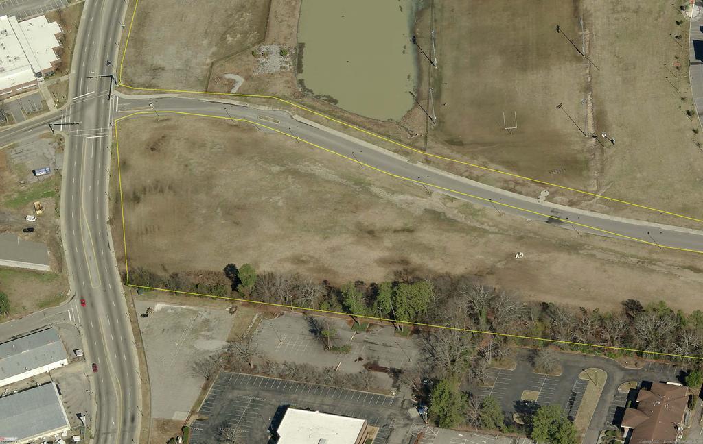
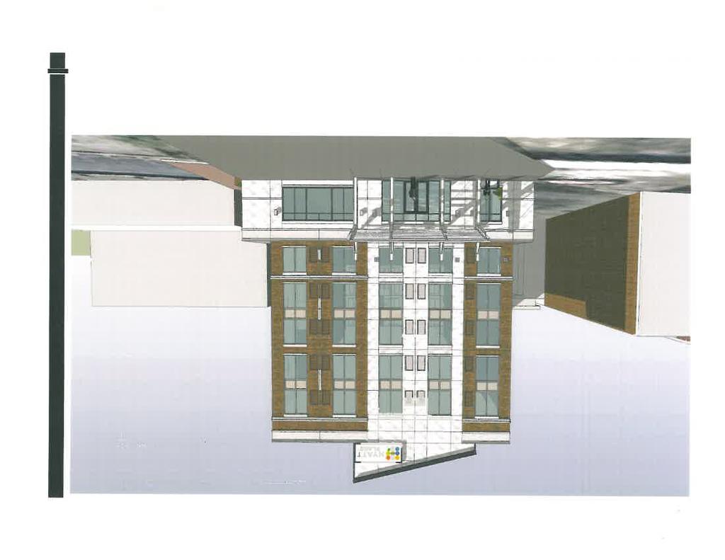
51 COLUMBIA CITY COUNCIL PUD-C AMENDMENT CASE SUMMARY AMEND THE PUD-C (COMMERCIAL PLANNED UNIT DEVELOPMENT) AT 823 GERVAIS STREET Public Hearing July 17, 2012 Eau Claire Print Building, 3907 Ensor Avenue Columbia, South Carolina Subject Property: 823 Gervais Street, TMS# Council District: 2 Proposal: Applicant: Amend the PUD-C for the construction of a 130-room hotel Winford Lindsay, Winford Lindsay Architect Present Use: Parking Lot Proposed Use: Hotel Staff Recommendation: PC Recommendation: Detail: Approve subject to staff comments Approve subject to staff comments except for those relating to landscaping beyond what is proposed by applicant; however, if additional landscaping can be achieved, PC is supportive. (5-2) 05/02/2011 This PUD-C established for this parcel includes language that any development on what is labeled as Parcel 2 is to be processed as a major amendment. This PUD was established to facilitate a mixed-use development anchored by the historic Columbia Supply Building. The original PUD was approved during the height of the real estate boom as a much larger scale development that included a total of 89,500 square feet with more contemplated on then parcel 3 to return at a later date. This previous proposal contemplated providing no parking on site; instead accommodating it through a mix of street and garage options. The downturn in the economy forced a revision to the plan which necessitated the major amendment in Changes to the development plan included permitting a different phasing of the development and a focus on the redevelopment of the Columbia Supply Building with only minor modifications, reserving the remaining parcel for future development. The original and revised plans, including building elevations and site plans were approved by Planning Commission, DDRC, and City Council. The current development plan is for a mixed-use structure fronting Gervais Street with a pedestrian connection through the parking area to Lady Street. The new proposal does not include any structures on the parcel fronting Lady Street and instead will provide onsite parking for the development, which was not provided for in the original PUD: a source of contention among some at the time. Relief from the zoning ordinance granted in the proposed language include relaxation of the landscaping requirements, reduction in parking requirements, increase in sign area, and reduced step-back for the upper floors above 50 feet. The D/DRC has reviewed and approved the revised design of the buildings with the requirement of a design of a feature to address Lady PAGE 1 OF 3
52 Staff has heard concerns about permitting the height of the building as proposed due to the historic district; however, there clearly is precedent for approval of a very similar building in the 2007 PUD where a majority of the building height was seventy-five feet instead of the proposed majority of the building at sixty-seven feet with the accent feature on Lady Street reaching seventy-five for a small area. Please note that a traffic impact and access study was completed and reviewed and approved by the City s Traffic Engineer. A copy of the study is on file in the Zoning Office. Staff recommends approval of the PUD revisions and site plans subject to the conditions listed below with landscaping, provision for screening the existing pedestrian walkway, and improvements to Gervais and Lady Streets of primary note. Case History: 06/07/07 DDRC approves Certificate of Design Approval for new construction of office 07/09/07 Planning Commission defers consideration to August 08/06/07 Planning Commission recommends approval of PUD-C 10/03/07 City Council grants second reading approval of rezoning 04/06/09 Planning Commission recommends approval of Major Amendment to permit phasing of project 06/03/09 City Council grants second reading approval of Major Amendment 04/12/12 DDRC approves Certificate of Design Approval for hotel CITY AGENCY COMMENTS FOR PUD SITE PLAN REVIEW John Fellows and Amy Moore, Planning Recommend Approval with Conditions: Landscaping shall be provided per all City landscaping ordinances and DD guidelines with regards to surface parking lot. If the proposed permanent parking lot is incapable of meeting the required landscaping the project shall provide alternate means of compliance as developed between the developer and City staff. Additionally, screening shall be required between the parking lot s west edge and the alley. Site lighting shall not exceed 14 feet in height to coordinate height with existing improvements within the district. Lighting need not be of a historical style or identical to public facilities, but shall be of a pedestrian scale with regard to height, material, design, and illumination. A variety of lighting is encouraged within pedestrian walkways, and plaza areas. Lighting of landscape features such as plants and walls is encouraged. A lighting plan shall be provided prior to construction for review by the planning department do to the nature of surrounding uses. Lady Street Streetscape Modifications of streetscape, sidewalks, lighting, street furnishings, and plantings shall maintain the design of the original streetscape. Plans shall be submitted to Forestry, Engineering and Planning for review. Irrigation within the street right of way shall be maintained throughout construction. Any mid block crossing shall be submitted for review by Forestry, Engineering and Planning for review. Design of any mid block crossing shall maintain the sprit of the Lady Street streetscape, sidewalks, lighting, street furnishings, and plantings. PAGE 2 OF 3
53 Robert Harkins, Plans Examiner Scott Rogers, Utilities David Brewer, Traffic Engineering David Koon, Fire Department Nancy Lee Trihey, Land Development Planner Sara Hollar, Forestry Tracy Mitchell - Stormwater Robert Sweatt Streets Gervais Street The existing two curb cuts on Gervais Street shall be removed and curb and sidewalks to match existing streetscape shall be installed. One ADA compliant ramp for a Taxi drop off area shall be provided if such drop off area is approved. If a Taxi drop off area is not provided additional on street parking shall be provided. Streetscape shall include brick accent band to match existing bands to the east and west. One shade tree with tree grate shall be provided. Plans shall be submitted to Forestry, Engineering, and Planning for review and approval prior to any submission to SCDOT for encroachments. Recommend Approval with Conditions: If a loading/unloading zone is provided [i.e. taxi] then it must be HC accessible. Recommend Approval with Conditions: 1) Any needed upgrade, extension or relocation of City utilities must be provided by the developer. 2) Must meet State and City of Columbia sedimentation & storm drainage regulations. 3) Any privately owned/maintained utilities or permanent structures cannot be located inside exclusive City of Columbia utility easements. Recommend Approval (based upon Traffic Impact and Access Study findings) Recommend Approval with Conditions: The Fire Department Connection shall be located within 100' from the fire hydrant. Recommend Approval with Conditions: Modify landscape plan to meet ordinance requirements to include: Shade tree within 40 of every parking space (16 spaces w/out shade tree); Tree-planting area minimum of 200 square feet (3 islands have less than 90 sf); 60% of all tree-planting areas must contain living plants (not just mulched); Street yard requirement of 1 shade tree per 40 of frontage (e.g., has only one tree along Lady 3 required); With masonry wall, 40% of standard evergreen requirement in street yard; Plant list with specs reflecting compliance with code re size/type trees & shrubs; Tree DFS (density factor for the site) calculations showing provision of 40 DFS units for the site (includes replacement of trees previously planted for Miller Valentine dev t, which Hyatt would remove to build hotel); Provision of irrigation for all required plants. Provide appropriate screening for dumpster. Recommend Approval with Conditions: The tree on Gervais street will not be removed if it interferes with the awning but may be trimmed by the City if needed. The relocation of the bump outs on Lady Street will need to be coordinated with Forestry and Beautification. We request to meet on site and review before starting work in right-of-way. The plant material to be added back must be approved by F&B and be consistent with the plant material on the other bump outs on Lady Street. The irrigation must be working through out and at the completion of the project. Recommend Approval with Conditions: Must provide pre-to-post developed hydrology analysis. Water quality and quantity must be addressed through models and controls appropriate for the site. Aim to avoid pushing water on adjacent property or road for safety. Recommend Approval. PAGE 3 OF 3


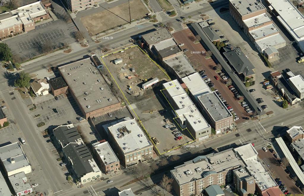
54 Zoning Map Department of Planning & Development Services C-4 PUD Amendment / Site Plan Review 823 Gervais Street TMS# LINCOLN ST µ Legend INTERSTATES RAILROADS CITY LIMITS FEMA FP PUD-C LINCOLN ST ZONING MX-2 D-1 RS-1 RS-1A RS-1B RS-2 RS-3 C-1 C-2 C-3 C-3A C-4 C-5 PUD-C GADSDEN ST LADY ST RD M-1 LINCOLN ST RD-2 M-2 RG-1 PUD-C RG-1A PUD-LS RG-2 PUD-LS-E RG-3 PUD-LS-R UTD PUD-R MX-1 OUT OF CITY DD DISTRICT DP DISTRICTS PD DISTRICT 1 inch = 115 feet ORIGINAL PREPARATION/DATE: This map was prepared by: Andrew Livengood May DD M-1 PUD-C West Gervais Historic Commercial District - DP DISCLAIMER: The City of Columbia Department of Planning and Development Services data represented on this map or plan is the product of compilation, as produced by others. It is provided for informational purposes only and the City of Columbia makes no representation as to its accuracy. Its use without field verification is at the sole risk of the user. PUD-C PUD-C GERVAIS ST West Gervais Historic Protection Area - DP GERVAIS ST NO NAME ** DATA SOURCE - CITY OF COLUMBIA, GIS DIVISION
55

56 MEMORANDUM TO: Planning Commission FROM: Amy Moore, DDRC staff CC: DATE: 4/13/12 RE: DDRC comments regarding Hyatt Place site plan At their December 8 th, 2011 meeting, the Design/Development Review Commission reviewed the hotel plans for the Hyatt Place Hotel which is proposed to be built at 823 Gervais Street, Parcel 2. This parcel stretches the entirety of the block from Gervais to Lady Streets. The lot falls both within the West Gervais Historic Commercial District as well as the City s Design District. While the hotel was conditionally approved, the D/DRC had some concerns about how the site plan might meet the intent of the Design District guidelines. Guidelines for the Design District are directed in part toward creating a pedestrian-friendly, lively, and engaging experience for visitors and residents on the district s streets; this is accomplished a variety of ways, two of which are to keep building edges along the street and placing parking lots on the interior of blocks. The D/DRC regarded this as difficult to accomplish as the hotel s proposal was to place a parking lot on Lady Street instead of extending the hotel edge to this point. A partial solution was found in the D/DRC s recommendation to the applicants to construct a wall of sorts along Lady Street which will visually serve as a building edge; this is still in process and will come back to the D/DRC for review. However, other concerns remained and the D/DRC unanimously passed a motion to convey some recommendations to the Planning Commission which has regulatory authority for the site. These comments were intended to minimize the negative impact of a surface parking lot along the street: To follow parking requirements more closely as outlines in the original PUD to minimize on-site parking; To maximize the use of compact car spaces; To minimize visibility from the street edge to the parking lot; To increase landscaping within the lot; To increase the space along the pedestrian thoroughfare along the 808 Lady Street side of the property; To look at one way parking circulation with angled parking; and To meet the tree ordinance. Design/Development Review Commission Planning Department Historic Preservation Urban Design Phone/ Fax/
57

58
59

60

61
62
63

64

65

66

67

68
69
70
71

72

73

74

75

76


77
CITY COUNCIL ANNEXATION CASE SUMMARY 941 SPEARS CREEK COURT ANNEX AND ASSIGN M-1 INTERIM ZONING
 CITY COUNCIL ANNEXATION CASE SUMMARY 941 SPEARS CREEK COURT ANNEX AND ASSIGN M-1 INTERIM ZONING 1 st Reading May 8, 2012 City Council Chambers, 3 rd Floor, City Hall, 1737 Main Street Columbia, South Carolina
PLANNING COMMISSION ANNEXATION, COMPREHENSIVE PLAN MAP AMENDMENT, AND ZONING MAP AMENDMENT CASE SUMMARY
 Subject Property: Applicant: PLANNING COMMISSION ANNEXATION, COMPREHENSIVE PLAN MAP AMENDMENT, AND ZONING MAP AMENDMENT CASE SUMMARY 385 SPEARS CREEK CHURCH ROAD ANNEX, ASSIGN LAND USE CLASSIFICATION UEMF
BOARD OF ZONING APPEALS CASE SUMMARY FOR VARIANCE REQUEST. 707 Catawba Street
 BOARD OF ZONING APPEALS CASE SUMMARY FOR VARIANCE REQUEST 707 Catawba Street November 8, 2016 at 10:00 A.M. City Council Chambers, 1737 Main Street, 3 rd Floor Columbia, South Carolina Case Number: 16-065-V
BOARD OF ZONING APPEALS CASE SUMMARY FOR VARIANCE REQUEST. 325 Veterans Road
 BOARD OF ZONING APPEALS CASE SUMMARY FOR VARIANCE REQUEST 325 Veterans Road April 11, 2017 at 10:00 A.M. City Council Chambers, 1737 Main Street, 3 rd Floor Columbia, South Carolina Case Number: 2017-0031-V
PLANNING COMMISSION MAP AND TEXT AMENDMENT CASE SUMMARY
 PLANNING COMMISSION MAP AND TEXT AMENDMENT CASE SUMMARY REZONE FROM RS-1 (SINGLE FAMILY RESIDENTIAL) TO RS-1, -DP (SINGLE FAMILY RESIDENTIAL, DESIGN PRESERVATION) AT 730 BELTLINE BOULEVARD January 6, 2014
RICHLAND COUNTY COUNCIL ZONING PUBLIC HEARING
 RICHLAND COUNTY COUNCIL ZONING PUBLIC HEARING MAY 27, 2014 RICHLAND COUNTY COUNCIL ZONING PUBLIC HEARING MAY 27, 2014 SC 215 Joyce Dickerson 176 Bill Malinowski 21 26 Torrey Rush Julie Ann Dixon!( Jim
CITY OF PAPILLION PLANNING COMMISSION STAFF REPORT MAY 27, 2015 AGENDA REVISE ZONING MAP MISC
 PLANNING COMMISSION STAFF REPORT MAY 27, 2015 AGENDA REVISE ZONING MAP MISC-15-0006 I. GENERAL INFORMATION A. APPLICANT: City of Papillion 122 East Third St. Papillion, NE 68046 B. REQUESTED ACTION: Approval
CITY COUNCIL SPECIAL MEETING THURSDAY, SEPTEMBER 1, :00 P.M. CITY COUNCIL CHAMBER, CITY HALL 2401 MARKET STREET BAYTOWN, TEXAS AGENDA
 CITY OF BAYTOWN NOTICE OF MEETING CITY COUNCIL SPECIAL MEETING THURSDAY, SEPTEMBER 1, 2016 5:00 P.M. CITY COUNCIL CHAMBER, CITY HALL 2401 MARKET STREET BAYTOWN, TEXAS 77520 AGENDA CALL TO ORDER AND ANNOUNCEMENT
Agenda Item. Item: 11a
 Agenda Item Item: 11a Issue under Consideration: Ordinance No. 2014-38 - To rezone two parcels located at 3629 and 3641 Melton Avenue approximately 320 feet east of the intersection of Highway 17 Business
CITY COUNCIL TEXT AMENDMENT CASE SUMMARY
 CITY COUNCIL TEXT AMENDMENT CASE SUMMARY AMEND THE PRIVATE DORMITORY ORDINANCE, SECTION 17-321, TO PERMIT THE USE WITH CONDITIONS IN THE C-3 (GENERAL COMMERCIAL) ZONING DISTRICT Public Hearing November
STAFF REPORT. Planning and Zoning Case 16-20FP Staff: Michael Peterman, City Planner Date: May 23, 2016
 STAFF REPORT Planning and Zoning Case 16-20FP Staff: Michael Peterman, City Planner Date: May 23, 2016 GENERAL INFORMATION Application: Applicant: Location: Existing Land Use/Zoning: Future Land Use Designation:
TOWN OF LYONS, COLORADO ORDINANCE NO. 1017
 TOWN OF LYONS, COLORADO ORDINANCE NO. 1017 AN ORDINANCE OF THE BOARD OF TRUSTEES OF THE TOWN OF LYONS ANNEXING TO THE TOWN OF LYONS CERTAIN REAL PROPERTY OWNED BY THE TOWN OF LYONS WHEREAS, the Town of
Agenda Information Sheet
 Page 90 Agenda Information Sheet December 13, 2018 Agenda Item Z-18-10 - Conduct a public hearing and consider approval of an ordinance rezoning a 33.4 tract of land out of the H. Teal Survey Abstract
REPORT TO THE SHASTA COUNTY PLANNING COMMISSION
 REPORT TO THE SHASTA COUNTY PLANNING COMMISSION PROJECT IDENTIFICATION: REGULAR AGENDA GENERAL PLAN AMENDMENT GPA18-0003 AND ZONE AMENDMENT ZA18-0004 AREA 3 - SOUTHWEST PALO CEDRO: GILBERT DRIVE CONTINUED
CITY OF PAPILLION PLANNING COMMISSION STAFF REPORT MAY 31, 2017 AGENDA REVISE ZONING MAP 2017 ANNEXATION NO. 2 MISC
 I. GENERAL INFORMATION A. APPLICANT: 122 East Third St. Papillion, NE 68046 CITY OF PAPILLION PLANNING COMMISSION STAFF REPORT MAY 31, 2017 AGENDA REVISE ZONING MAP 2017 ANNEXATION NO. 2 MISC-17-0005 B.
BOARD OF ZONING APPEALS CASE SUMMARY FOR SPECIAL EXCEPTION. NX 900 Greenlawn Drive
 BOARD OF ZONING APPEALS CASE SUMMARY FOR SPECIAL EXCEPTION NX 900 Greenlawn Drive January 9, 2018 at 10:00 A.M. City Council Chambers, 1737 Main Street, 3 rd Floor Columbia, South Carolina Case Number:
Town of Cary, North Carolina Rezoning Staff Report 14-REZ-24 Indian Wells Road Properties Town Council Meeting November 20, 2014
 Town of Cary, North Carolina Rezoning Staff Report 14-REZ-24 Indian Wells Road Properties Town Council Meeting November 20, 2014 REQUEST To amend the Town of Cary Official Zoning Map by revising a condition
R e z o n i n g A p p l i c a t i o n S u b m i s s i o n R e q u i r e m e n t s
 H O R R Y C O U N T Y P L A N N I N G & Z O N I N G 1 3 0 1 2 N D A V E., S U I T E 1 D - 0 9 C O N W A Y, S. C. 2 9 5 2 6 P H O N E : 8 4 3. 9 1 5. 5 3 4 0 F A X : 8 4 3. 9 1 5. 6 3 4 1 R e z o n i n
LOCATION MAP: AERIAL PHOTOGRAPH, 2015:
 LOCATION MAP: AERIAL PHOTOGRAPH, 2015: ORDINANCE NO. AN ORDINANCE OF THE CITY OF BRYAN, TEXAS, AMENDING CHAPTER 130, ZONING, OF THE CITY OF BRYAN CODE OF ORDINANCES, BY CHANGING THE ZONING CLASSIFICATION
contiguous to the City boundaries in the vicinities of the South Wilmington Analysis Area
 #4513 Sponsor: Council Member Harlee AN ORDINANCE TO (1) ANNEX AND REZONE THE FOLLOWING EIGHT (8) PARCELS OF LAND: (A) TERRITORY 1, BEING 800 SOUTH MARKET STREET (TAX PARCEL ID NO. 10-001.00-015), 810
CHAPTER 2 GENERAL PROVISIONS
 CHAPTER 2 GENERAL PROVISIONS 200 ZONING DISTRICTS ESTABLISHED 201 SUPPLEMENTAL DISTRICTS ESTABLISHED 202 OFFICIAL ZONING MAP ESTABLISHED 203 DISTRICT BOUNDARY DESCRIPTION and INTERPRETATION 204 LIMITATION
AGENDA ITEM. Two Separate Public Hearings relating to the Eighth Avenue S./Orange Place Enclave Annexation
 DATE PREPARED: May 20, 2015 AGENDA ITEM PREPARED BY: Marisa M. Barmby, AICP, Senior Planner Central Florida Regional Planning Council AGENDA DATE: June 1, 2015 and June 8, 2015 REQUESTED ACTION: Two Separate
PLANNING COMMISSION MEETING November 6, :00 P.M. COMMISSION ROOM/CITY HALL AGENDA
 City of Auburndale Auburndale, Florida 33823 #1 Bobby Green Plaza P. O. Box 186 Community Development Department Phone (863) 965-5530 Fax (863) 965-5507 PLANNING COMMISSION MEETING 4:00 P.M. COMMISSION
City of Grand Forks Staff Report
 City of Grand Forks Staff Report Planning and Zoning Commission March 6, 2019 City Council March 18, 2019 Agenda Item: 4-1 (Preliminary) Preliminary approval of the plat of University Place First Resubdivision
CITY OF CAMPBELL RIVER PUBLIC HEARING AGENDA
 CITY OF CAMPBELL RIVER PUBLIC HEARING AGENDA PUBLIC HEARING MEETING, Tuesday, September 6, 2016 at 6:30 PM in the City Hall Council Chambers, 301 St. Ann's Road, Campbell River, BC. Page The agenda presents
SUBDIVISION APPLICATION
 SUBDIVISION APPLICATION City of Horn Lake Planning Department 3101 Goodman Road, W Horn Lake, MS 38637 662-342-3559 Fax: 662-342-3485 Applications due the 1st working day of the month. Submit application
AGENDA. All items listed below are considered routine and will be enacted by one motion and without discussion.
 AGENDA Agenda Meeting of the Southern Pines Town Council August 5, 2015, 7:00 PM, Community Room, Southern Pines Police Department 450 West Pennsylvania Avenue 1. Manager s Comments 2. Consent Agenda All
Planning & Development 881 Senoia Road Tyrone GA, (770) Tax Map Number: Date. Date Annexation will become effective and official:
 Tax Map Number: Date. Date Annexation will become effective and official:") TOWN OF TYRONE Planning & Development 881 Senoia Road Tyrone GA, 30290 (770) 487-4038 Tax Map Number: Date Date Annexation will become effective and official: Address of subject property: Owner of Property:
TOWN OF TYRONE Planning & Development 881 Senoia Road Tyrone GA, 30290 (770) 487-4038 Tax Map Number: Date Date Annexation will become effective and official: Address of subject property: Owner of Property:
Subject: Ordinance 1657, Annexation of 3.55 acres of land at 3015 and 3001 Parker Road.
 Agenda Report 2016-12-12-09 Date: December 8, 2016 To: From: Russ Axelrod, Mayor Members, West Linn City Council Jennifer Arnold, Planning Department Through: John Boyd, Interim Community Development Director
Preliminary Plat/Final Plat Application
 Melissa Municipal Center 3411 Barker Avenue Melissa, Texas 75454 Phone: (972) 838-2036 Applicant: Date: Address: Phone: Contact: Fax: E-mail: Propose Addition Name: Acres: Existing Zoning: Propose Zoning:
PLANNING SERVICES MEMORANDUM
 PLANNING SERVICES MEMORANDUM March 27, 2017 TO: FROM: SUBJECT: City Council Brian Schweigl, Associate Planner First reading, refer to Plan Commission, and schedule a public hearing on a proposed ordinance
City of Shenandoah Development Package
 Upon completion return application to Development@shenandoahtx.us City of Shenandoah Development Package Documentation includes the following: Fee Schedule Platting Development Check List & Outline Development
1. Roll Call. 2. Minutes a. September 26, 2016 Regular Meeting. 3. Adoption of the Agenda. 4. Visitors to Be Heard
 1. Roll Call City of Vermillion Planning Commission Agenda 5:30 p.m. Regular Meeting Tuesday, October 11, 2016 Large Conference Room 2 nd Floor City Hall 25 Center Street Vermillion, SD 57069 2. Minutes
SUBDIVISION APPLICATION: RECOMBINATION PLAT or EXEMPT PLAT
 SUBDIVISION APPLICATION: RECOMBINATION PLAT or EXEMPT PLAT Pursuant to Article 7, Section 155.706 of the Unified Development Code, an owner of land within the jurisdiction of the Town (or a duly authorized
ORDINANCE N0.18-ll6. WHEREAS, City has prepared a Service Plan for said tract which is attached as Exhibit "A" to this ordinance; &
 c: 0 ORDINANCE N0.18-ll6 AN ORDINANCE ANNEXING THE HEREINAFTER DESCRIBED TERRITORY TO THE CITY OF FORT STOCKTON, PECOS COUNTY, TEXAS, AND EXTENDING THE BOUNDARY LIMITS OF SAID CITY SO AS TO INCLUDE SAID
MEMO. Planning and Inspections Department
 Planning and Inspections Department P. O. Box 70, 308 E Stadium Drive, Eden NC 27289-0070/Telephone 336-623-2110/Fax 336-623-4057 MEMO To: Honorable Mayor and City Council Thru: Brad Corcoran, City Manager
ACTION FORM BRYAN CITY COUNCIL
 ACTION FORM BRYAN CITY COUNCIL DATE OF COUNCIL MEETING: July 8, 2014 DATE SUBMITTED: June 17, 2014 DEPARTMENT OF ORIGIN: Development Services SUBMITTED BY: Maggie Dalton MEETING TYPE: CLASSIFICATION: ORDINANCE:
PROVO CITY MUNICIPAL ANNEXATION GUIDE
 COMMUNITY DEVELOPMENT PROVO CITY MUNICIPAL ANNEXATION GUIDE This guide has been prepared to outline the procedures and requirements of annexing unincorporated territory into Provo City. Annexations are
City of Fayetteville, Arkansas Page 1 of 1
 City of Fayetteville, Arkansas 113 West Mountain Street Fayetteville, AR 72701 (479) 575-8323 Legislation Text File #: 2018-0399, Version: 1 VAC 18-6148 (1901 S. HARDING PL./THOMPSON): AN ORDINANCE TO
WHEREAS, the Planning and Zoning Commission, at its meeting on July 9, 2018, recommended the approval of the zoning request by the City Council; and
 BILL NO. ORDINANCE NO. AN ORDINANCE ESTABLISHING A LI: LIGHT INDUSTRIAL DISTRICT FOR PROPERTY RECENTLY ANNEXED INTO THE CITY OF WARRENSBURG, MISSOURI, LOCATED AT THE NORTHEAST CORNER OF THE INTERSECTION
HB-S RM8-S RS9 RM18 HB-S RS9 DOCKET #: W2872. PROPOSED ZONING: RM8-S (Child Day Care Center) EXISTING ZONING: RS9 and RM8-S
 EXISTING ZONING: RS9 and RM8-S") 150' 80' RS9 UNIVERSITY PW STANLEYVILLE DR HB-S LB 123' 70' PROPOSED BELTWAY!( RM8-S S 289' NOEL DR 202' NITA AV MILL CREEK DOCKET #: W2872 PROPOSED ZONING: RM8-S (Child Day Care Center) EXISTING ZONING:
150' 80' RS9 UNIVERSITY PW STANLEYVILLE DR HB-S LB 123' 70' PROPOSED BELTWAY!( RM8-S S 289' NOEL DR 202' NITA AV MILL CREEK DOCKET #: W2872 PROPOSED ZONING: RM8-S (Child Day Care Center) EXISTING ZONING:
PLANNING COMMISSION REPORT Regular Agenda Public Hearing Item PRD TO RM15; ACRES; 2101 EXCHANGE CT (KES)
") PC Staff Report 7/22/15 Z-14-00515 Item No. 3-1 PLANNING COMMISSION REPORT Regular Agenda Public Hearing Item PC Staff Report 7/22/15 ITEM NO. 3 PRD TO RM15; 9.818 ACRES; 2101 EXCHANGE CT (KES) Z-14-00515:
PC Staff Report 7/22/15 Z-14-00515 Item No. 3-1 PLANNING COMMISSION REPORT Regular Agenda Public Hearing Item PC Staff Report 7/22/15 ITEM NO. 3 PRD TO RM15; 9.818 ACRES; 2101 EXCHANGE CT (KES) Z-14-00515:
MINUTES OF THE TOWN OF LADY LAKE REGULAR PLANNING AND ZONING BOARD MEETING LADY LAKE, FLORIDA. May 8, :30 p.m.
 MINUTES OF THE TOWN OF LADY LAKE REGULAR PLANNING AND ZONING BOARD MEETING LADY LAKE, FLORIDA May 8, 2017 5:30 p.m. The Planning and Zoning Board Meeting was held in the Town Hall Commission Chambers at
ORDINANCE NO.:
 ORDINANCE NO.: 2013-098 Authorizing the City Manager to execute a Limited Warranty Deed conveying the improvements (an approximate 300 space parking garage) known as the Bell South Parking Garage constructed
AGENDA COLLETON COUNTY COUNCIL SPECIAL MEETING FRIDAY, DECEMBER 16, :00 P.M. COUNTY COUNCIL CHAMBERS, OLD JAIL BUILDING
 AGENDA COLLETON COUNTY COUNCIL SPECIAL MEETING FRIDAY, DECEMBER 16, 2016 1:00 P.M. COUNTY COUNCIL CHAMBERS, OLD JAIL BUILDING 1. Call to Order 2. Invocation and Pledge of Allegiance 3. Roll Call 4. Old
LARAMIE COUNTY PLANNING & DEVELOPMENT DEPARTMENT
 LARAMIE COUNTY PLANNING & DEVELOPMENT DEPARTMENT Planning Building MEMORANDUM TO: FROM: Laramie County Planning Commission Nancy M. Trimble, Associate Planner DATE: November 9, 2017 TITLE: Review and action
LINCOLN COUNTY PLANNING & INSPECTIONS DEPARTMENT
 LINCOLN COUNTY PLANNING & INSPECTIONS DEPARTMENT 302 NORTH ACADEMY STREET, SUITE A, LINCOLNTON, NORTH CAROLINA 28092 704-736-8440 OFFICE 704-736-8434 INSPECTION REQUEST LINE 704-732-9010 FAX To: Board
City of Ferndale CITY COUNCIL STAFF REPORT
 SUBJECT: Final Plat Approval DATE: January 19, 2016 FROM: Haylie Miller, Assistant Planner PRESENTATION BY: Haylie Miller City of Ferndale CITY COUNCIL STAFF REPORT MEETING DATE: January 19, 2016 AGENDA
City Commission Agenda Cover Memorandum
 City Commission Agenda Cover Memorandum Originating Department: Planning & Zoning (PZ) Meeting Type: Regular Agenda Date: 03/14/2016 Advertised: Required?: Yes No ACM#: 20760 Subject: Resolution No. 86-16
RECITALS. PPAB v3 PPAB v4
 STATE OF SOUTH CAROLINA ) AGREEMENT FOR DEVELOPMENT COUNTY OF OCONEE ) FOR JOINT COUNTY INDUSTRIAL/BUSINESS ) PARK (OCONEE-PICKENS INDUSTRIAL COUNTY OF PICKENS ) PARK PROJECT MACKINAW) THIS AGREEMENT for
For Office Use Only. Permit No. Fee: $ $ per proposed lot (AN ADDITIONAL 10% CODE COMPLIANCE FEE WILL BE CHARGED)
") For Office Use Only Permit No. Fee: $1600 + $560.00 per proposed lot (AN ADDITIONAL 10% CODE COMPLIANCE FEE WILL BE CHARGED) LAND PARTITION FOREST (Conditional Use) Crook County Planning Department 300
For Office Use Only Permit No. Fee: $1600 + $560.00 per proposed lot (AN ADDITIONAL 10% CODE COMPLIANCE FEE WILL BE CHARGED) LAND PARTITION FOREST (Conditional Use) Crook County Planning Department 300
March 26, Sutter County Planning Commission
 March 26, 2003 To: Re: Sutter County Planning Commission Agenda Item #12: Public hearing on Rezoning #03-04 to change the zoning classification of two parcels totaling 324+ acres from the AG (General Agricultural)
A variance to exceed the maximum sign height by 3-feet - being a variance from the Sign Ordinance, Appendix A, Section 22.c.(1)
") City of Friendswood Memo To: From: Zoning Board of Adjustment Members Brian Rouane, Building fficial Becky Summers, Development Coordinator Date: August 21, 2018 Subject: 1765 S. Friendswood Drive The
City of Friendswood Memo To: From: Zoning Board of Adjustment Members Brian Rouane, Building fficial Becky Summers, Development Coordinator Date: August 21, 2018 Subject: 1765 S. Friendswood Drive The
AGENDA ITEM SUMMARY GLADES COUNTY BOARD OF COUNTY COMMISSIONERS
 AGENDA ITEM SUMMARY GLADES COUNTY BOARD OF COUNTY COMMISSIONERS SUBJECT: Case Number COMP17-01, Legend Moto LLC This is a Legislative Hearing. DEPARTMENT REQUEST: The Community Development Department requests
Sketch Plan 2018 Bargersville Plan Commission Application Kit
 Sketch Plan 2018 Bargersville Plan Commission Application Kit For Commercial, Industrial, and Residential Developments At least 31 days prior to the intended filing of the Primary Plat or Development Plan
PC# SUBJECT: Rezoning request from R-3, Single-Family Residential District to R-3A, Single-Family Residential District.
 Agenda Cont d. PC#2012-01 SUBJECT: Rezoning request from R-3, Single-Family Residential District to R-3A, Single-Family Residential District. LOCATION: Properties located on E. & W. Marion St., N. & S.
RM18 RS9 RM12 RS9 !( S DOCKET #: W3120 PROPOSED ZONING: GB-L EXISTING ZONING: HB-S. PETITIONER: Bank of North Carolina for property owned by Same
 DELANE DR DOCKET #: W3120 RM18 BARRY ST PROPOSED ZONING: GB-L RS9 EXISTING ZONING: HB-S IP OLD GREENSBORO RD WALES ST DENVER ST GEORGE BIG REDD CT LOUISE WILSON LN RM12!(DS MOSES LUCAS CT 585' 627' HB-S
SKAMANIA COUNTY PLANNING COMMISSION
 SKAMANIA COUNTY PLANNING COMMISSION AGENDA Tuesday, November 13, 2018 @ 6:00 PM SKAMANIA COUNTY COURTHOUSE ANNEX, LOWER MEETING ROOM 170 NW VANCOUVER AVENUE, STEVENSON, WA 98648 I. CALL TO ORDER II. III.
AGENDA COLLETON COUNTY COUNCIL REGULAR MEETING TUESDAY, FEBRUARY 5, :00 P.M. COUNTY COUNCIL CHAMBERS, OLD JAIL BUILDING
 AGENDA COLLETON COUNTY COUNCIL REGULAR MEETING TUESDAY, FEBRUARY 5, 2013 6:00 P.M. COUNTY COUNCIL CHAMBERS, OLD JAIL BUILDING 1. Call to Order 2. Invocation 3. Present Colors and Lead Pledge of Allegiance-
AGENDA ITEM SUMMARY GLADES COUNTY BOARD OF COUNTY COMMISSIONERS
 AGENDA ITEM SUMMARY GLADES COUNTY BOARD OF COUNTY COMMISSIONERS SUBJECT: Case Number COMP17-02, RFYC, LLC This is a Legislative Hearing. DEPARTMENT REQUEST: The Community Development Department requests
THE AREA PLAN COMMISSION OF ST. JOSEPH COUNTY, IN AGENDA
 THE AREA PLAN COMMISSION OF ST. JOSEPH COUNTY, IN AGENDA Tuesday, January 17, 2017 Fourth-Floor Council Chambers 3:30 p.m. County-City Building, South Bend, IN EXECUTIVE SESSION: A. Election of Officers
AN ORDINANCE TO CREATE THE ALDEN RIDGE PUD As Recommended to the Lowell Township Board by the Lowell Township Planning Commission January 11, 2016
 CHARTER TOWNSHIP OF LOWELL COUNTY OF KENT, MICHIGAN AN ORDINANCE TO CREATE THE ALDEN RIDGE PUD As Recommended to the Lowell Township Board by the Lowell Township Planning Commission January 11, 2016 At
CITY OF KENNER DEPARTMENT OF PLANNING 1610 REV. RICHARD WILSON DR. KENNER, LOUISIANA PHONE (504)
") CITY OF KENNER DEPARTMENT OF PLANNING 1610 REV. RICHARD WILSON DR. KENNER, LOUISIANA 70062 PHONE (504) 468-7280 CONDITIONAL USE APPLICATION PRE-APPLICATION MEETING It is recommended that you meet with
CITY OF KENNER DEPARTMENT OF PLANNING 1610 REV. RICHARD WILSON DR. KENNER, LOUISIANA 70062 PHONE (504) 468-7280 CONDITIONAL USE APPLICATION PRE-APPLICATION MEETING It is recommended that you meet with
ORDINANCE NO. 12, 782
 ORDNANCE NO. 12, 782 AN ORDNANCE OF THE CTY COUNCL OF THE CTY OF BAYTOWN, TEXAS, MAKNG CERTAN FNDNGS; PROVDNG FOR THE EXTENSON OF CERTAN BOUNDARY LMTS OF THE CTY OF BAYTOWN, TEXAS, AND THE ANNEXATON OF
MINOR SUBDIVISION FINAL PLAT APPLICATION Town of Apex, North Carolina
 MINOR SUBDIVISION FINAL PLAT APPLICATION Town of Apex, North Carolina This document is a public record under the North Carolina Public Records Act and may be published on the Town s website or disclosed
COUNCIL COMMUNICATION Work Plan #
 Meeting Date: March 15, 2016 COUNCIL COMMUNICATION Agenda Item: Agenda Location: Work Plan # Consent Calendar 162 Legal Review: _X_ 1 st Reading 2 nd Reading Subject: Three ordinances approving the annexation
Staff Report Annexation & Initial Zoning Case#RZ
 Staff Report Annexation & Initial Zoning Case#RZ2014-3-1 Zoning Board Public Hearing: Thursday April 3, 2014 City Council: Introduction 4/15/2014 Final 5/6/2014 Attachments: Application, Property Information
Findings and Recommendations of the Dover Planning Commission And Annexation Report Information
 PETITION FOR Annexation Plan Amendment to Comprehensive Plan Update 2003 and PETITION TO ANNEX AND ZONE PROPERTY Before The Dover City Council November 8, 2004 Owner: Equitable Owner: Location: Tax Map
Spartanburg County Planning and Development Department
 Spartanburg County Planning and Development Department MINUTES Planning and Development Commission County Council Chambers, 4:30 p.m. June 05, 2018 Members Present: Members Absent: Staff Present: Whit
CITY OF LABELLE ORDINANCE BROWARD AVE LLC PLANNED UNIT DEVELOPMENT REZONE
 CITY OF LABELLE ORDINANCE 2019-04 BROWARD AVE LLC PLANNED UNIT DEVELOPMENT REZONE AN ORDINANCE OF THE CITY OF LABELLE, FLORIDA, AMENDING THE CITY OF LABELLE ZONING MAP FOR PROPERTY LOCATED SOUTH OF BROWARD
City of Columbia ENgiNEEriNg regulations Part 12: application For NEW WatEr service table of CoNtENts Paragraph Description Page No.
 City of Columbia Engineering Regulations PART 12: APPLICATION FOR NEW WATER SERVICE Table of Contents Paragraph Description Page No. 12.1 General 12-1 12.2 Agencies Assigning Street Numbers 12-1 12.3 Required
Town of Holly Springs Town Council Meeting Agenda Cover Sheet
 Town of Holly Springs Town Council Meeting Agenda Cover Sheet Meeting Date: Feb. 19, 2019 Agenda Item #: 8c Agenda Placement: Public Hearing (Recognitions (awards, proclamations), Requests & Communications
PLANNED UNIT DEVELOPMENT (PUD) AREA PLAN/REZONING REVIEW PROCEDURE
 AREA PLAN/REZONING REVIEW PROCEDURE") PLANNED UNIT DEVELOPMENT (PUD) AREA PLAN/REZONING REVIEW PROCEDURE Professional inquiries will be made to our Township Planning Consultant, Township Engineer, and Township Attorney to get their opinions
PLANNED UNIT DEVELOPMENT (PUD) AREA PLAN/REZONING REVIEW PROCEDURE Professional inquiries will be made to our Township Planning Consultant, Township Engineer, and Township Attorney to get their opinions
THE AREA PLAN COMMISSION OF ST. JOSEPH COUNTY, IN AGENDA
 THE AREA PLAN COMMISSION OF ST. JOSEPH COUNTY, IN AGENDA Tuesday, June 20, 2017 Fourth-Floor Council Chambers 3:30 p.m. County-City Building, South Bend, IN PUBLIC HEARINGS: 1. Rezonings: A. A combined
Lake County Planning, Building and Development Department
 SUBMISSION CHECKLIST FOR SUBDIVISION FINAL PLAT Lake County Planning, Building and Development Department 500 W. Winchester Rd. Unit 101 Libertyville, Illinois 60048-1331 Telephone (847) 377-2600 E-mail:
WHEREAS, on August 5, 1999, the Town Council adopted Resolution No. 906 approving Second Amendments to the StoneRidge Development Agreement; and
 RESOLUTION NO. 1879 A RESOLUTION OF THE MAYOR AND COMMON COUNCIL OF THE TOWN OF PRESCOTT VALLEY, A MUNICIPAL CORPORATION OF ARIZONA, APPROVING AND ADOPTING A FINAL DEVELOPMENT PLAN (FDP14-002) FOR A SUBDIVISION
31, Township 29 South, Range 25 East, Polk County, Florida, as depicted by the Land Use Plan attached
 ORDINANCE NO. 2013-04 AN ORDINANCE AMENDING THE ZONING MAP OF THE CITY OF BARTOW, FLORIDA, REZONING APPROXIMATELY 2. 2 ACRES OF LAND OWNED BY BALA3I OF POLK COUNTY, LLC AND LOCATED IN SECTION 31, TOWNSHIP
LARAMIE COUNTY PLANNING & DEVELOPMENT DEPARTMENT
 LARAMIE COUNTY PLANNING & DEVELOPMENT DEPARTMENT Planning Building MEMORANDUM TO: FROM: Laramie County Planning Commission Bryan Nicholas, Associate Planner DATE: February 14, 2019 TITLE: Review and action
Spartanburg County Planning and Development Department
 Spartanburg County Planning and Development Department MINUTES Planning and Development Commission County Council Chambers, 4:30 p.m. June 6, 2017 Members Present: Members Absent: Staff Present: Whit Kennedy,
CITY OF MURFREESBORO BOARD OF ZONING APPEALS
 CITY OF MURFREESBORO BOARD OF ZONING APPEALS Regular Meeting, September 26, 2012, at 1:00 p.m. City Hall, 111 West Vine Street, Council Chambers, 1 st Floor 1. Call to order A G E N D A 2. Consideration
MCGUIRE AV 374 COUNTRY CLUB RD RANDALL ST RYANDALE RD FLOODWAY FLOODWAY FRINGE
 SILAS CREEK MCGUIRE AV OLD COUNTRY CLUB RD 249 RYANDALE RD 323 374 COUNTRY CLUB RD S 441 SEDGEFIELD LN (PVT) QUEENSBURY RD FLOODWAY FLOODWAY FRINGE RANDALL ST SOUTHWIN DR November 19, 2004 Paul E. Burke,
MEMORANDUM. Jeff Day, P.Eng. Director of Community Planning & Development January 4, George V. Harvie, Chief Administrative Officer
 E.01 MEMORANDUM The Corporation of Delta Community Planning & Development To: From: Date: Subject: File No.: cc: Mayor and Council Jeff Day, P.Eng. Director of Community Planning & Development January
LINCOLN COUNTY PLANNING & INSPECTIONS DEPARTMENT
 LINCOLN COUNTY PLANNING & INSPECTIONS DEPARTMENT 302 NORTH ACADEMY STREET, SUITE A, LINCOLNTON, NORTH CAROLINA 28092 704-736-8440 OFFICE 704-736-8434 INSPECTION REQUEST LINE 704-732-9010 FAX To: Board
Planning and Inspections Department
 Planning and Inspections Department P. O. Box 70, 308 E Stadium Drive, Eden NC 27289-0070/Telephone 336-623-2110/Fax 336-623-4057 MEMO TO: Honorable Mayor and City Council THRU: Brad Corcoran, City Manager
Presented WASILLA Date Action Taken: It)/;::;- I q /17 ALASKA. Other: Verifie
/;::;- I q /17 ALASKA. Other: Verifie") CITY OF Presented WASILLA Date Action Taken: It)/;::;- I q /17 ALASKA Other: Verifie CITY COUNCIL INFORMATIONAL MEMORANDUM IM No. 17-01: A recommendation from the Planning Commission that the City Council
CITY OF Presented WASILLA Date Action Taken: It)/;::;- I q /17 ALASKA Other: Verifie CITY COUNCIL INFORMATIONAL MEMORANDUM IM No. 17-01: A recommendation from the Planning Commission that the City Council
MEMORANDUM. City Council. David J. Deutsch City Manager. Resolution R TLBT, LLC Annapolis Road Annexation Plan. DATE: September 3, 2015
 MEMORANDUM TO: FROM: RE: City Council David J. Deutsch City Manager Resolution R-66-15 TLBT, LLC 13401 Annapolis Road Annexation Plan DATE: September 3, 2015 In accordance with the Annotated Code of Maryland,
APPLICATION PROCEDURES FOR A MAJOR SUBDIVISION PRELIMINARY PLAT
 APPLICATION PROCEDURES FOR A DEFINITION: The subdivision of a tract of land into at least three (3) residential, commercial, or industrial parcels, including the remainder of the original parcel, fronting
TO ASSIGN ALL RIGHTS, TITLE AND INTEREST IN AND TO A PORTION OF THAT CERTAIN UNCODIFIED ORDINANCE TO THE CODE OF THE COUNTY OF SPARTANBURG NO
 NO. O-6- AN ORDINANCE TO ASSIGN ALL RIGHTS, TITLE AND INTEREST IN AND TO A PORTION OF THAT CERTAIN UNCODIFIED ORDINANCE TO THE CODE OF THE COUNTY OF SPARTANBURG NO. O-3-33 CERTIFYING A PORTION OF DRAYTON
PLANNING & DEVELOPMENT
 PLANNING & DEVELOPMENT STAFF REPORT Rezoning PETITION: APPLICANT: PROPERTY OWNER: TYPE OF REQUEST: SIZE OF TRACT: LOCATION: (#17-22) Rezone from A-PUD (Agri-Business Planned Unit Development) to A-PUD
WHEREAS, the City of Camdenton Planning and Zoning Commission held a public hearing on March 14, 2017 to consider this rezoning request; and
 BILL NO. 2679-17 ORDINANCE NO. 2644-17 AN ORDINANCE AMENDING THE CODE OF THE CITY OF CAMDENTON, TITLE IV: ZONING CODE, CHAPTER 400: ZONING REGULATIONS, SECTION 400.030: DISTRICT BOUNDARIES, REZONING PROPERTY
Doug Viets - Mary Neale - Shauncy Maloy - Adrian Bellis - Edward Hemminger -
 TOWN OF FARMINGTON PLANNING BOARD RESOLUTION LETTER OF CREDIT ESTIMATE AND RECOMMENDATION TO TOWN BOARD TOTAL AMOUNT - $ 206,213.60 Phase 1, Farmington Dental Project WHEREAS, the Town of Farmington Planning
Staff Report Dunes West (Wood Park Drive & Highway 41) For reference, the Zoning Code and Land Development Regulations are available online.
 For reference, the Zoning Code and Land Development Regulations are available online.") AGENDA ITEM Staff Report Dunes West (Wood Park Drive & Highway 41) For reference, the Zoning Code and Land Development Regulations are available online. PLANNED DEVELOPMENT AMENDMENT REQUEST PUBLIC HEARING:
AGENDA ITEM Staff Report Dunes West (Wood Park Drive & Highway 41) For reference, the Zoning Code and Land Development Regulations are available online. PLANNED DEVELOPMENT AMENDMENT REQUEST PUBLIC HEARING:
CITY OF ELK GROVE CITY COUNCIL STAFF REPORT
 AGENDA ITEM NO. 9.2 CITY OF ELK GROVE CITY COUNCIL STAFF REPORT AGENDA TITLE: A public hearing to consider a Specific Plan Amendment to the Laguna Ridge Specific Plan and a Rezone of approximately 4.14
ANNEXATION IMPACT REPORT
 ANNEXATION IMPACT REPORT Project: RED MOUNTAIN RANCH ANNEXATION 17500 Hwy 6 (unincorporated Eagle County) Eagle, CO 81631 Prepared By: Town of Eagle Morgan Landers, Town Planner 200 Broadway St Eagle,
PLANNING COMMISSION REPORT Regular Agenda - Public Hearing Item
 Z-15-00469 Item No. 6A- 1 PLANNING COMMISSION REPORT Regular Agenda - Public Hearing Item PC Staff Report 11/16/15 ITEM NO. 6A GPI, RM12, & RS40 TO RM12; 14.756 ACRES; 5200 & 5300 CLINTON PKWY (SLD) Z-15-00469:
AGENDA BILL. Beaverton City Council Beaverton, Oregon BUDGET IMPACT AMOUNT BUDGETED $0
 AGENDA BILL SUBJECT: Beaverton City Council Beaverton, Oregon An Ordinance Annexing a Portion of Three Parcels Along NW 112 1 h Avenue to the City of Beaverton, Adding the Property to the Central Beaverton
City of Fayetteville, Arkansas Page 1 of 1
 City of Fayetteville, Arkansas 113 West Mountain Street Fayetteville, AR 72701 (479) 575-8323 Legislation Text File #: 2018-0148, Version: 1 VAC 18-6097 (W. OF BEECHWOOD AVE. & 15TH ST./BARRETT DEV. GROUP):
EDGERTON CITY HALL PLANNING COMMISSION MEETING REGULAR SESSION March 12, 2019
 EDGERTON CITY HALL PLANNING COMMISSION MEETING REGULAR SESSION The met in regular session with Chair John Daley calling the meeting to order at 7:00 p.m. All present participated in the Pledge of Allegiance.
ORDINANCE NO. NOW, THEREFORE, BE IT ORDAINED BY THE CITY COUNCIL OF THE CITY OF BRYAN, TEXAS:
 LOCATION MAPS: ORDINANCE NO. AN ORDINANCE OF THE CITY OF BRYAN, TEXAS, AMENDING CHAPTER 130, ZONING, OF THE CITY OF BRYAN CODE OF ORDINANCES, BY CHANGING THE ZONING CLASSIFICATION FROM AGRICULTURAL - OPEN
CITY OF WAUPACA CITY PLAN COMMISSION MEETING WEDNESDAY, FEBRUARY 14, :15 P.M. COUNCIL CHAMBERS, CITY HALL AGENDA: 1.
 CITY OF WAUPACA CITY PLAN COMMISSION MEETING WEDNESDAY, FEBRUARY 4, 208 5:5 P.M. COUNCIL CHAMBERS, CITY HALL CITY OF WAUPACA MISSION STATEMENT: The city of Waupaca s mission is to lead creatively, plan