AGENDA ITEM SUMMARY GLADES COUNTY BOARD OF COUNTY COMMISSIONERS
|
|
|
- Corey Dean
- 5 years ago
- Views:
Transcription
1 AGENDA ITEM SUMMARY GLADES COUNTY BOARD OF COUNTY COMMISSIONERS SUBJECT: Case Number COMP17-02, RFYC, LLC This is a Legislative Hearing. DEPARTMENT REQUEST: The Community Development Department requests approval of Case Number COMP BACKGROUND/SUMMARY OF REPORT: RFYC LLC is requesting a change to the Future Land Use Map (FLUM) designation of 4.61acres from Residential to Commercial. There is a companion rezoning request for a change from Residential General to Commercial General. There is also a special exception request to allow expansion of the yacht club use in the form of a boat staging basin on the subject site. The special exception will not be scheduled for a public hearing unless the plan amendment and rezoning are approved. The subject site is located south of Williams Road, west of Turkey Creek Avenue and north of Rudder Lane. PLANNING AND ZONING BOARD RECOMMENDATION: The Planning and Zoning Board recommended approval of Case Number COMP MOTION FOR APPROVAL: I move to approve adoption of AN ORDINANCE OF THE GLADES COUNTY BOARD OF COUNTY COMMISSIONERS, AMENDING THE GLADES COUNTY COMPREHENSIVE PLAN BY REVISING THE FUTURE LAND USE MAP FROM RESIDENTIAL TO COMMERCIAL FOR 4.61 ACRES OF LAND LOCATED ON RUDDER LANE AND WILLIAMS ROAD; PROPERTY OWNER RFYC LLC; CASE NUMBER COMP17-02; PROVIDING FOR INCLUSION OF ORDINANCE AND REVISED FUTURE LAND USE MAP IN THE COMPREHENSIVE PLAN; AND PROVIDING FOR AN EFFECTIVE DATE. based on the findings and analysis in the staff report dated May 1, 2017 and findings presented at the public hearing. MOTION FOR DENIAL: I move to deny the adoption of an ordinance amending the Future Land Use Map of 4.61± acres of land located south of Williams Road from Residential to Commercial, Case Number COMP17-02, for the following reasons. Request By: Meeting Date: June 13, 2017 Inga Williams, Comm. Dev. Director Agenda #
2 ORDINANCE AN ORDINANCE OF THE GLADES COUNTY BOARD OF COUNTY COMMISSIONERS, AMENDING THE GLADES COUNTY COMPREHENSIVE PLAN BY REVISING THE FUTURE LAND USE MAP FROM RESIDENTIAL TO COMMERCIAL FOR 4.61 ACRES OF LAND LOCATED ON RUDDER LANE AND WILLIAMS ROAD; PROPERTY OWNER RFYC LLC; CASE NUMBER COMP17-02; PROVIDING FOR INCLUSION OF ORDINANCE AND REVISED FUTURE LAND USE MAP IN THE COMPREHENSIVE PLAN; AND PROVIDING FOR AN EFFECTIVE DATE. WHEREAS, The Board of County Commissioners of Glades County recognizes the need to plan for orderly growth and development; and WHEREAS, Chapter 163, Florida Statutes, provides for amendments to adopted Comprehensive Plans; and WHEREAS, the County has received and reviewed a Small Scale Plan Amendment application for an amendment to the Future Land Use Map for County s Comprehensive Plan from RFYC, LLC, for property owned by RFYC, LLC, and WHEREAS, said application being reviewed by the County s Community Development Department and submitted to the Planning and Zoning Board and the Board of County Commissioners with a staff report, which determined such application to be consistent with the Comprehensive Plan and appropriate to the future land uses within the County; and WHEREAS, in a duly noticed public hearing on May 9, 2017, the Glades County Planning and Zoning Board heard the Future Land Use Map amendment and said Board recommended to the Board of County Commissioners that the application be approved; and WHEREAS, in a duly noticed public hearing on June 13, 2017, the Board of County Commissioners gave full and complete consideration of the record, consisting of the Staff Recommendation, the Planning and Zoning Board minutes and recommendation, the documents on file with the County and the testimony of all interested parties, and has found that that approval of Case# COMP17-02 is consistent with the Glades County Comprehensive Plan; and WHEREAS, the proposed amendment was reviewed in accordance with Chapter , Florida Statutes and no valid objection has been made to the proposed map amendment; and WHEREAS, after due consideration, the Board has found that the requirements and conditions of Chapter 163, Florida Statutes, as they relate to this petition have been met and that is in the best interest of Glades County that the Future Land Use Map be COMP17-02 Page 1 of 4
3 amended. NOW, THEREFORE, BE IT ORDAINED, by the Glades County Board of County Commissioners that: SECTION 1. THIS ORDINANCE shall be known as the RFYC LLC Plan Amendment to the Future Land Use Map, COMP17-02 and shall be effective within the County limits of Glades County, Florida. SECTION 2. This Small Scale Plan Amendment to the Comprehensive Plan Future Land Use Map is adopted pursuant to the provisions of Chapter , Florida Statutes. SECTION 3. The real properties identified in Exhibit A, being located south of Williams Road, which consists of a 4.61± acres, is hereby re-designated on the Future Land Use Map of the Glades County Comprehensive Plan from Residential to Commercial. SECTION 4. It is the intention of the Board of County Commissioners of Glades County, Florida, and it is hereby provided that the provision of this Ordinance and the revision of the Future Land Use Map shall become and made a part of the Glades County Comprehensive Plan. SECTION 5. In the event that any portion of this Ordinance is for any reason held invalid or unconstitutional by any court of competent jurisdiction, such portion shall be deemed a separate, distinct and independent provision, and such holding shall not affect the validity of the remaining portions of this Ordinance. SECTION 6. This ordinance shall be effective in accordance with Chapter , Florida Statutes. The foregoing Ordinance was offered by Commissioner, who moved its adoption. The motion was seconded by Commissioner, and being put to a vote, the vote was as follows: John Ahern Donald Strenth Weston Pryor Timothy Stanley Donna Storter Long [REMAINDER OF PAGE INTENTIONALLY LEFT BLANK] [NEXT PAGE FOR SIGNATURE] COMP17-02 Page 2 of 4
4 PASSED AND DULY ADOPTED by the Board of County Commissioners of Glades County Florida, during a Public Hearing, this 13th day of June, ATTEST: BOARD OF COUNTY COMMISSIONERS GLADES COUNTY, FLORIDA Sandra Brown Clerk of the Circuit Court John Ahern Chairman APPROVED AS TO FORM AND LEGAL SUFFICIENCY Richard W. Pringle County Attorney COMP17-02 Page 3 of 4
5 Exhibit A A PARCEL OF LAND BEING A PORTION OF THOSE CERTAIN PARCELS DESCRIBED IN OFFICIAL RECORDS BOOK 115, PAGE 657, AND OFFICIAL RECORDS BOOK 260, PAGE 689 OF THE PUBLIC RECORDS OF GLADES COUNTY, FLORIDA, SAID PARCEL LYING AND BEING IN SECTION 26, TOWNSHIP 42 SOUTH, RANGE 30 EAST, GLADES COUNTY, FLORIDA AND BEING MORE PARTICULARLY DESCRIBED AS FOLLOWS: BEGINNING AT THE NORTHEAST CORNER OF A SUBDIVISION KNOWN AS ADDITION NO. 1 TO TURKEY CREEK SUBDIVISION, ACCORDING TO THE PLAT THEREOF RECORDED IN PLAT BOOK 3, PAGE 94 OF THE PUBLIC RECORDS OF GLADES COUNTY, FLORIDA, SAID POINT OF BEGINNING, ALSO BEING THE SOUTHEAST CORNER OF THAT CERTAIN PARCEL OF LAND DESCRIBED IN OFFICIAL RECORDS BOOK 115, PAGE 657 OF THE PUBLIC RECORDS OF GLADES COUNTY, FLORIDA; THENCE S W, ALONG THE NORTH LINE OF SAID SUBDIVISION, SAID LINE ALSO BEING THE SOUTH LINE OF SAID OFFICIAL RECORDS BOOK 115, PAGE 657, FEET; THENCE CONTINUING ALONG SAID NORTH LINE OF SAID SUBDIVISION, N W FEET; THENCE CONTINUING ALONG SAID NORTH LINE OF SAID SUBDIVISION, S W FEET TO THE WEST BOUNDARY OF SAID SUBDIVISION; THENCE S E, ALONG THE WEST BOUNDARY OF SAID SUBDIVISION, FEET; THENCE S W, LEAVING SAID WEST LINE OF SAID SUBDIVISION, FEET INTO AN EXISTING CANAL, TO THE SOUTHWEST CORNER OF SAID LANDS DESCRIBED IN OFFICIAL RECORDS BOOK 115, PAGE 657; THENCE N W ALONG THE WESTERN BOUNDARY OF SAID LANDS, FEET TO THE NORTHWEST CORNER OF SAID LANDS; THENCE N E, ALONG THE NORTH LINE OF SAID LANDS, SAID LINE ALSO BEING THE SOUTHERLY LINE OF THE LANDS DESCRIBED IN OFFICIAL RECORDS BOOK 260, PAGE 689 OF THE PUBLIC RECORDS OF GLADES COUNTY, FLORIDA, FEET; THENCE N E, LEAVING SAID SOUTH LINE, FEET; THENCE S E, FEET TO AN INTERSECTION WITH THE WEST LINE OF THAT CERTAIN PARCEL OF LAND DESCRIBED IN OFFICIAL RECORDS BOOK 120, PAGE 222, OF THE PUBLIC RECORDS OF GLADES COUNTY, FLORIDA; THENCE S W, ALONG SAID WEST LINE, FEET TO THE SOUTHWEST CORNER OF SAID LANDS, SAID POINT LYING ON THE NORTH LINE OF THE AFOREMENTIONED PARCEL OF LAND DESCRIBED IN OFFICIAL RECORDS BOOK 115, PAGE 657 OF THE PUBLIC RECORDS OF GLADES COUNTY, FLORIDA; THENCE N E, ALONG SAID NORTH LINE, FEET TO THE NORTHEAST CORNER OF SAID LANDS, SAID POINT ALSO BEING THE SOUTHEAST CORNER OF THE AFOREMENTIONED PARCEL DESCRIBED IN OFFICIAL RECORDS BOOK 120, PAGE 222 OF THE PUBLIC RECORDS OF GLADES COUNTY, FLORIDA, SAID POINT ALSO LYING AND BEING ON THE WEST BOUNDARY OF TURKEY CREEK SUBDIVISION, ACCORDING TO THE PLAT THEREOF RECORDED IN PLAT BOOK 3, PAGE 48 OF THE PUBLIC RECORDS OF GLADES COUNTY, FLORIDA; THENCE S W, ALONG SAID WEST BOUNDARY OF SAID TURKEY CREEK SUBDIVISION, ALSO BEING THE EAST BOUNDARY OF SAID PARCEL DESCRIBED IN OFFICIAL RECORDS BOOK 115, PAGE 657 OF THE PUBLIC RECORDS OF GLADES COUNTY, FLORIDA, FEET TO THE POINT OF BEGINNING. SAID PARCEL CONTAINING A COMPUTED ACREAGE OF 4.61 ACRES MORE OR LESS. COMP17-02 Page 4 of 4
 designation of 4.")

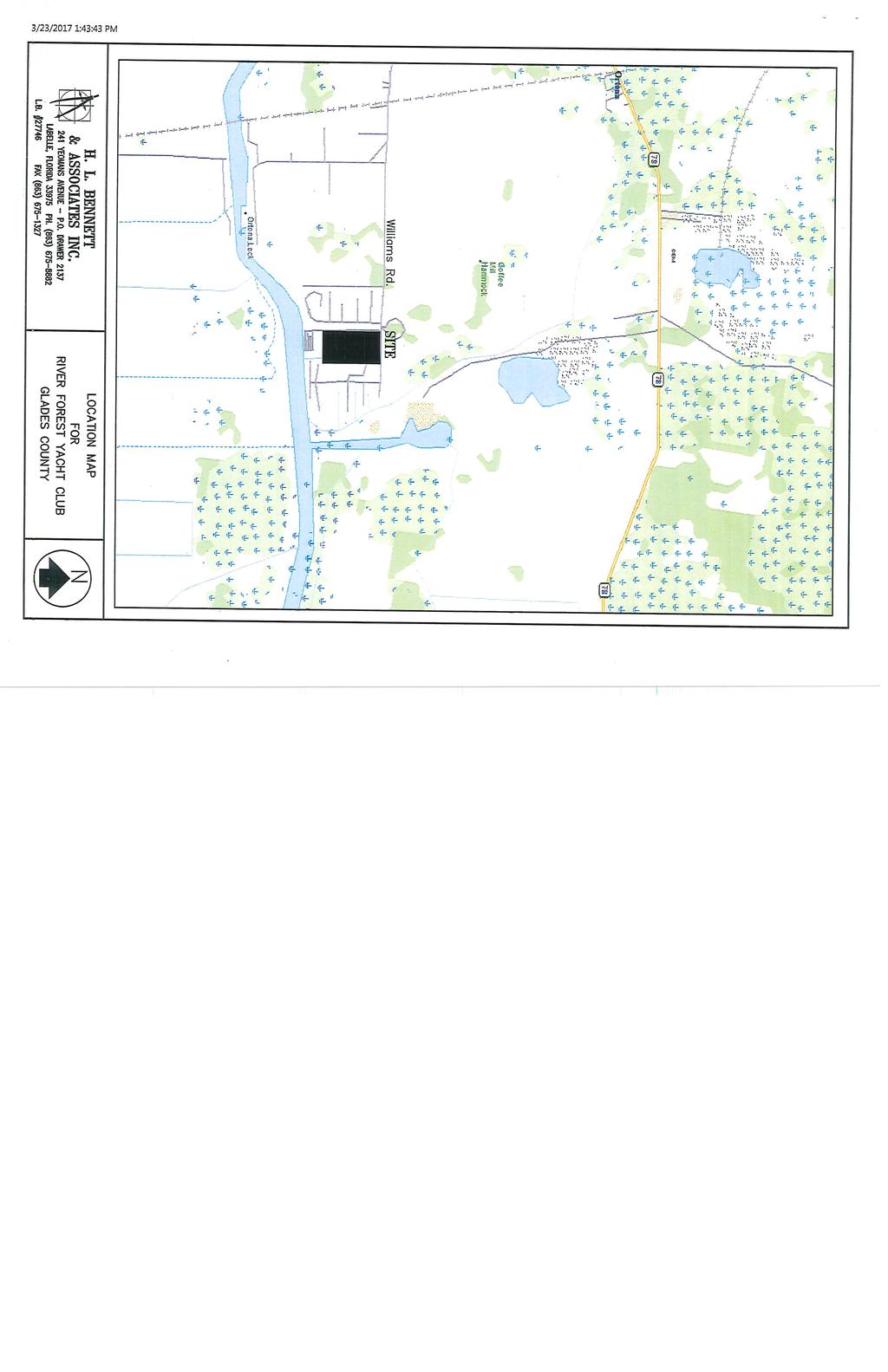
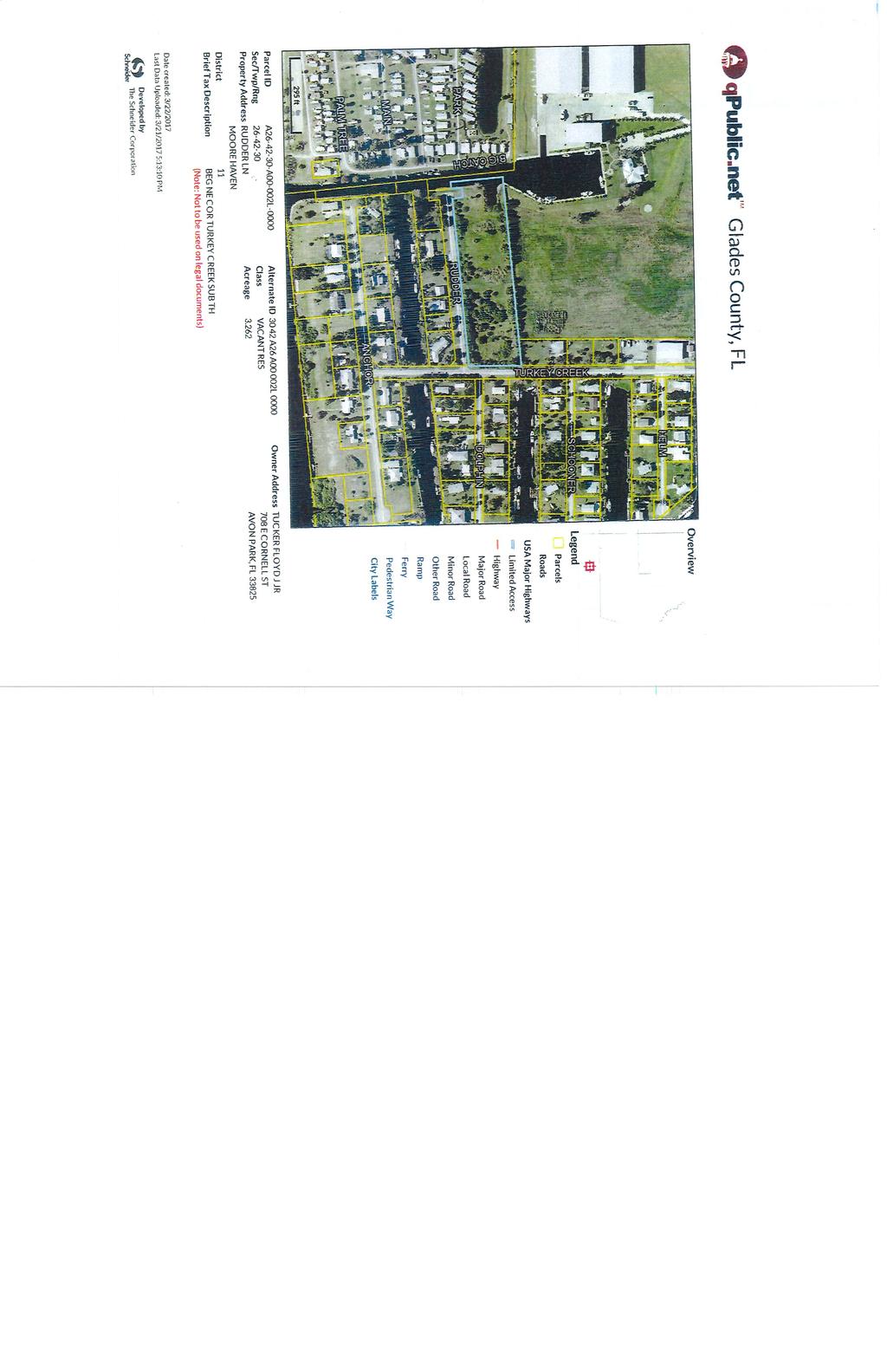
6 Glades County Staff Report and Recommendation Unified Staff Report for Small Scale Plan Amendment and Rezoning CASE NUMBERS: COMP17-02 and RZ17-02 DATE of STAFF REPORT: May 1, 2017 CASE TYPE: Application for a small scale plan amendment to the Future Land Use Map and a rezoning REQUEST: Change the Future Land Use Map (FLUM) designation of 4.61 acres from Residential to Commercial and a Rezoning from Residential General (RG) to Commercial General (C-2). APPLICANT and PROPERTY OWNER: RFYC, LLC STAFF RECOMMENDATION: Approval of the plan amendment and rezoning LOCATION: South of Williams Road, east of Turkey Creek Avenue and north of Rudder Lane. Hatched area is the subject site COMP17-02 & RZ17-02, RFYC, LLC 1
, Residential Mixed (RM), Residential General (RG), Commercial General (C-2). Hatched area is subject site Sec. 125-165.")
7 I. ZONING DISTRICT DESIGNATIONS A. Current Zoning Designations The Subject Site is zoned Residential General (RG). Surrounding Zoning Districts are Open Use Agricultural (OUA), Residential Mixed (RM), Residential General (RG), Commercial General (C-2). Hatched area is subject site Sec RG residential general district. (a) Scope and intent. This section apples to the RG residential general district. This district is intended to include lands developed and suitable for development as indicated in the comprehensive land development plan, for low to medium density urban residential use, with a compatible mixture of residential types. Special emphasis is on a compatible mixture of residential uses. DISTRICT CLASSIFICATION PARCEL AREA BUILDABLE UNITS/ACRE SETBACKS (FT) MAXIMUM BUILDING MAXIMUM LOT HEIGHT (FT) COVERAGE DIMENSIONS WIDTH (FT) FRONT REAR SIDES RG Residential General Single family 10,000 sq ft % Duplex 10,000 sq ft % Multifamily 6,222 sq ft % COMP17-02 & RZ17-02, RFYC, LLC 2

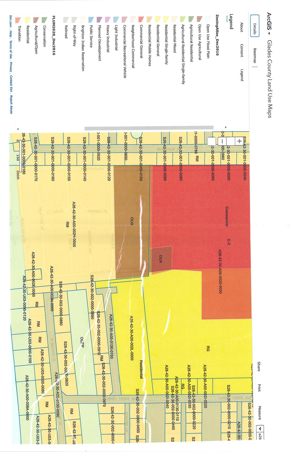
8 B. Proposed Zoning Designation Sec C-2 commercial general Scope and intent. This section applies to the C-2 commercial general district. This district is intended to create a mid-level district desirable in situations dealing with uses for which neighborhood commercial is too restrictive. Manufacturing of any type is prohibited. DISTRICT CLASSIFICATION PARCEL AREA BUILDABLE UNITS/ACRE SETBACKS (FT) MAXIMUM BUILDING HEIGHT (FT) DIMENSIONS WIDTH FRONT REAR SIDES (FT) C-2 Commercial General 22,500 sq ft % MAXIMUM LOT COVERAGE II. FUTURE LAND USE MAP DESIGNATIONS A. Existing Future Land Use Map The Subject Site is designated Residential. Surrounding designations are Commercial, Industrial, and Residential. Existing Future Land Use Map designation Policy I-1.4F: Land use definitions, densities and intensities of the Future Land Use Map series are as follows: COMP17-02 & RZ17-02, RFYC, LLC 3
9 Residential: Land areas used predominantly for housing with density of up to 7 units per acre. Uses may also include low-intensity non-residential uses such as neighborhood commercial uses including restaurants, barber shops, convenient food stores, movie rentals, houses of worship, public parks and plant nurseries; existing cemeteries; private child care centers and nonprofit private clubs of a fraternal or social character. Non residential uses shall develop at an intensity no greater than 0.25 floor area ratio and be buffered from residential uses. All non-residential uses shall be limited to a total amount of 100,000 square feet and shall not exceed 15,000 square feet at any one location for projects that are not associated with a PUD. Neighborhood retail commercial uses shall develop at an intensity no greater than 0.25 F.A.R and locate within 1,000 feet of the intersection of two arterial roads or the intersection of an arterial road and a collector road, and be appropriately buffered from residential uses. Projects greater than 150 units shall occur in the form of a Planned Unit Development, be compact, connect to central water and sewer, include a variety of residential units (single family units and multifamily units), and also include the following amenities: parks, and bicycle and pedestrian pathways that are connected in order to promote alternative modes of transportations. Projects greater than 500 units shall also include neighborhood retail uses. B. Proposed Future Land Use Map Commercial: Land areas which are predominantly connected with the sale, rental, and distribution of products, or performance of services. Densities shall be up to 24 units an acre for motel units; up to 30 units an acre for recreational vehicles; up to 0.5 floor area ratio for single story structures, with a minimum 0.4 site not covered with impervious surfaces; up to 1.0 floor area ratio for multi-story structures, with a minimum 0.4 site not covered with impervious surfaces. III. EXISTING USES The Subject Site is vacant. To the south and west is the Turkey Creek subdivision. To the west is the Meadowlark Shores RV Park. To the north is property owned by the applicant, River Forest. IV. ANALYSIS OF RELEVANT COMPREHENSIVE PLAN POLICIES Future Land Use Element Policy I-1.3B: Commercial and industrial developments shall be designed to meet the neighborhood, community or regional needs of the residents of Glades County. 1. Commercial rezoning and development will be limited based upon the commercial needs COMP17-02 & RZ17-02, RFYC, LLC 4
10 of the residents and the impacts of rezoning on adjacent lands. Additional zoning and development will be approved only upon determination by the Planning and Zoning Board (PZB) that there is a special need, or to meet the needs of transients. 2. Commercial and industrial facilities shall be required to incorporate site design characteristics which aesthetically complement the area within which they are to be located. 3. Commercial and industrial developments shall be reviewed for their impact on support facilities, including, but not limited to, roads, central water, sewage, and fire protection. When new or additional facilities are required, approval for the proposal shall be contingent upon a commitment by the developer to pay a fair share of costs. 4. Actions 1-3, above, will be incorporated into the County s Land Development Code and/or Regulations by the end of Staff Review: The subject site is located adjacent to the existing boat storage buildings and basin of the River Forest Yacht Club and will become part of their facility. The applicant proposes to dredge a second basin on the subject site that will be used as a staging basin as the existing basin is no longer adequate for the amount of boat traffic that the facility receives during peak season. The expansion of the yacht club facilities will meet community and regional needs. A boat storage facility is only allowed by special exception and the applicant has submitted a special exception application showing the basin. Access to the site will be internal except for an emergency entrance on Turkey Creek Avenue. Landscaping and buffering will be reviewed and applied as conditions through the special exception. Hours of operation will be made to match the existing hours of operation from the prior special exception (8 to 5 Monday through Saturday, 12 to 5 on Sunday. The following are minimum design requirements for development in the C-2 Zoning district. Commercial Design Requirements of Section are as follows: o A site plan indicating proposed uses and structures, driveways and parking areas, yards, buffering, a schedule for initiation and completion of development, and such other details. o Limitations on vehicular access. Except for utility and service vehicles, there shall be no vehicular access to the property through a residential district. o Site planning; limitations on operations. Site planning, design and location of structures and open spaces, and management of operations shall be such that orientation of commercial and related activities is toward the frontage on the street. There shall be no sales, service storage or display of goods or materials and no off-street loading operations, garbage or trash storage, or collection or disposal facilities visible in any portion of the property from any portion of any abutting residential district. Signs on the property shall be oriented away from any abutting residential district. Lighting of structures and premises on the property shall be so directed and shielded as to protect adjoining residential uses from nuisance effects. o Yard requirements; buffering. Yards and structural buffering shall be provided to minimize the impact of the development of any abutting residential district. The following minimum requirements may be increased to achieve a stated public purpose, but shall not be diminished: (1) Yards adjacent to streets shall be a minimum of 25 feet in depth. COMP17-02 & RZ17-02, RFYC, LLC 5
11 (2) Yards adjoining lot lines in any residential district shall be a minimum of 15 feet in minimum dimension. (3) All yards provided which abut any residential district shall be landscaped and maintained appropriate to the residential surrounds. No portion of any required yard abutting any residential district shall be used for off-street parking. (4) Where necessary to protect adjacent property in residential districts from lights, noise, or undesirable views, appropriate fences or walls may be required to be provided and maintained as required in this chapter. Policy I-1.4B: New development emphasizing employment opportunities and needed retail enterprises shall be located within proximity to Glades residents while meeting all infrastructure requirements. Such developments shall be compatible with and complement the existing architectural design and density of surrounding neighborhoods. 1. The Planning and Zoning Board (PZB) will include employment opportunities, compatibility with the surrounding community, architectural design and density as criteria in its plan review. Staff Review: This is an expansion of an existing development that already provides employment opportunities. The applicant expects four new employees will be needed after the expansion is complete. Economic Development Element Objective X-1.4: Promote and Support Economic Development and Job Creation Efforts. The County will strive to identify and attract new businesses and industries and provide a climate that promotes expansion of existing businesses and supports entrepreneurs. Policy X-1.4C: Existing business and industry are vital to the County's economy and the expansion of existing business and industry is an integral component in the diversification of the economic base. The County through the County Manager, or his designee will encourage the expansion of existing business and industry. Staff Review: The FLUM amendment and rezoning are proposed in order to allow expansion of an existing business and so the change in map designations would allow this to occur. V. ANALYSIS OF REZONING CONSIDERATIONS Existing potential 20 Single-family residential units or 46 Multi-family residential units. Potable Water Use: Potable water use is estimated at 125 gallons per capita per day (Infrastructure Element of the Comprehensive Plan). Estimating 2 persons per household, the current use of potable water could range from Under current zoning, the property could use 600 gallons per day to 11,500 gallons per day. Traffic generated at 9.57 trips per day per single-family unit would equal 191 total trips per day. Traffic generate at 6.65 trips per day per multifamily unit would equal 306± trips per day. Proposed potential COMP17-02 & RZ17-02, RFYC, LLC 6
12 200,811 square feet of commercial retail use. With a special exception, this subject site use will be limited to the yacht basin. There will be no potable water or sanitary sewer usage. There will be no impact to schools. The applicant s engineer has stated approximately 4 new employees would be hired and daily walk-in customer traffic is about 4 to 6 customers per day. The conclusion of the Trip Generation report is that trips generated by the expansion will not have an adverse impact on transportation infrastructure. Rezoning Considerations When recommending whether to rezone a classification of land, the factors listed below are used to evaluate the appropriateness of the proposed rezoning, where applicable: # EVALUATION CRITERIA STAFF FINDINGS 1 The proposed change is contrary to the established land use pattern. The proposed zoning is not contrary to the established land use pattern. There are other properties within this area that are zoned Commercial General and the subject site is an expansion of an existing use The proposed change would create an isolated district unrelated to adjacent and nearby districts The proposed change would materially alter the population pattern and thereby increase or overtax the load on public facilities, such as schools, utilities, streets, etc. Existing district boundaries are illogically drawn in relation to existing conditions on the property proposed for change. The proposed change would be contrary to the Future Land Use Map and would have an adverse effect on the Comprehensive Plan. Changed or changing conditions made the passage of the proposed amendment necessary. Changed or changing conditions will adversely influence living conditions in the neighborhood. The proposed change would not create an isolated district unrelated to adjacent and nearby districts. The proposed change is from residential to commercial. Staff concurs with the applicant s engineer, who has concluded that there are no adverse impacts to roads because of the expansion of the yacht business. There will be no impacts to public water, sewer or schools. N/A The proposed change will be consistent with the FLUM of Commercial if COMP17-02 is approved by the Board of County Commissioners. The applicants have stated that increased business make the creation of a new boat basin necessary. A change in the FLUM designation would make the proposed rezoning necessary. Potential adverse conditions can be mitigated by enhanced buffering and other site conditions as part of the Special Exception, and also during building permit site plan approval. COMP17-02 & RZ17-02, RFYC, LLC 7
13 The proposed change will create or excessively increase traffic congestion or otherwise affect public safety. The proposed change will create a drainage problem. The proposed change will seriously reduce light and air to adjacent areas. The proposed change will adversely affect property values in the adjacent area. The proposed change will be a deterrent to the improvement or development of adjacent property in accord with existing regulations. The proposed change will constitute a grant of special privilege to an individual owner as contrasted with the public welfare. There are substantial reasons why the property cannot be used in accord with existing zoning. Whether the change suggested is out of scale with the needs of the neighborhoods or the County. It is impossible to find other adequate sites in the County for the proposed use in districts already permitting such use. The traffic report by the applicant s engineer indicates that the proposed use will not create or excessively increase traffic congestion. Site planning will be required prior to development and any stormwater runoff will be required to be treated on-site. No. The proposed change is to allow the dredging of a new boat basin. No buildings will be placed on the subject site. Commercial development of the site should not decrease property values in adjacent areas. Commercial development of the site should not be a deterrent to any new homes that may be built in the Turkey Creek subdivision. The majority of those residential lots are already developed and it is a canal community whose residents are used to boat traffic. The property to the west is also developed and contains an RV Park. No. There are no substantial reasons why the property cannot be used in accord with existing zoning. No. It would be difficult to find other sites suitable for a new or expanded boat storage use. COMP17-02 & RZ17-02, RFYC, LLC 8
14 VI. GENERAL ANALYSIS The applicant is proposing to change the FLUM designation of 4.61 acres from Residential to Commercial and change the Zoning district from Residential General to Commercial General. The applicant has also submitted a Special Exception with plans for a new boat staging basin on the subject site. The subject site is adjacent to a developed residential subdivision to the east and south and an RV park to the west. Commercial development of the subject site would not prevent these uses from continuing. Existing regulations would mitigate impacts to the residential uses by requiring access to the site to be from Williams Road and requiring a landscape buffer of 10 feet consisting of a double hedge and 5 trees per 100 feet. A wall could be required and staff believes it will be necessary in order to protect the residents across Rudder Lane and Turkey Creek from increased noise. Clients of the RV Park are adjacent to the existing boat basin and so are already experiencing any impacts from such a use. Staff considers the change in FLUM designation to be consistent with the comprehensive plan policies that are relevant to this proposal. Staff considers the change in Zoning to positively meet the rezoning evaluation criteria. VII. RECOMMENDATION The plan amendment and the rezoning are consistent with the Glades County Comprehensive Plan. Staff recommends approval of the plan amendment and the rezoning and respectfully submits this staff report for your review. Inga Williams, AICP Director, Community Development Department COMP17-02 & RZ17-02, RFYC, LLC 9
15
16
17
18
19
20
21
22
23
24
25
26
27
28
29
30
31
32
33
34
35
36
37
Glades County Staff Report and Recommendation Unified Staff Report for Small Scale Plan Amendment and Rezoning
 Glades County Staff Report and Recommendation Unified Staff Report for Small Scale Plan Amendment and Rezoning CASE NUMBERS: COMP17-02 and RZ17-02 DATE of STAFF REPORT: May 1, 2017 CASE TYPE: Application
AGENDA ITEM SUMMARY GLADES COUNTY BOARD OF COUNTY COMMISSIONERS
 AGENDA ITEM SUMMARY GLADES COUNTY BOARD OF COUNTY COMMISSIONERS SUBJECT: Case Number COMP17-01, Legend Moto LLC This is a Legislative Hearing. DEPARTMENT REQUEST: The Community Development Department requests
Glades County Staff Report and Recommendation REZONING
 Glades County Staff Report and Recommendation REZONING CASE NUMBER: RZ15-01 DATE: October 2, 2015 CASE TYPE: Application for Rezoning REQUEST: J.J. Wiggins Memorial Trust is requesting a rezoning of 22.1±
ORDINANCE NO
 ORDINANCE NO. 2016 - AN ORDINANCE OF THE BOARD OF COUNTY COMMISSIONERS OF GLADES COUNTY, FLORIDA, AMENDING THE OFFICIAL ZONING MAP OF GLADES COUNTY FROM RESIDENTIAL SINGLE-FAMILY (RS) AND AGRICULTURAL
ACTION FORM BRYAN CITY COUNCIL
 ACTION FORM BRYAN CITY COUNCIL DATE OF COUNCIL MEETING: July 8, 2014 DATE SUBMITTED: June 17, 2014 DEPARTMENT OF ORIGIN: Development Services SUBMITTED BY: Maggie Dalton MEETING TYPE: CLASSIFICATION: ORDINANCE:
CITY OF LABELLE ORDINANCE BROWARD AVE LLC PLANNED UNIT DEVELOPMENT REZONE
 CITY OF LABELLE ORDINANCE 2019-04 BROWARD AVE LLC PLANNED UNIT DEVELOPMENT REZONE AN ORDINANCE OF THE CITY OF LABELLE, FLORIDA, AMENDING THE CITY OF LABELLE ZONING MAP FOR PROPERTY LOCATED SOUTH OF BROWARD
Dennis & Donna Blanchard, Agent. Dennis & Donna Blanchard/Disbrow Builders, Inc.
 Nassau County Growth Management Department 96161 Nassau Place Yulee, FL 32097 (904) 491-7328 (904) 491-3611 FAX Date of Hearing: March 3, 2015 Public Hearing Number: R15-001 BOARD MEMBERS Thomas Ford (Chairman)
Mayor Leon Skip Beeler and Members of the City Commission. Anthony Caravella, AICP, Director of Development Services
 CITY COMMISSION BRIEFING & Planning Board Report For Meeting Scheduled for November 4, 2010 Thousand Island Conservation Area Rezoning Ordinance 1519 FINAL ACTION TO: FROM: THRU: RE: Mayor Leon Skip Beeler
Midwest City, Oklahoma Zoning Ordinance
 2010 Midwest City, Oklahoma Zoning Ordinance 9/2/2010 Table of Contents Section 1. General Provisions... 5 1.1. Citation... 5 1.2. Authority... 5 1.3. Purpose... 5 1.4. Nature and Application... 5 1.5.
GLADES COUNTY, FLORIDA RESOLUTION NO
 GLADES COUNTY, FLORIDA RESOLUTION NO. 2016 - _ A RESOLUTION OF THE BOARD OF COUNTY COMMISSIONERS OF GLADES COUNTY, FLORIDA, ORDERING AND CALLING AN ELECTION ON GLADES COUNTY S AUTHORIZATION TO GRANT ECONOMIC
CITY OF BELLEVIEW PLANNING & ZONING BOARD AGENDA
 CITY OF BELLEVIEW PLANNING & ZONING BOARD AGENDA BELLEVIEW CITY HALL COMMISSION ROOM 5:30 PM IF A PERSON SHOULD DESIRE TO APPEAL ANY DECISION MADE BY THE BOARD, A VERBATIM RECORD OF THE PROCEEDINGS WHICH
ARTICLE B ZONING DISTRICTS
 ARTICLE B ZONING DISTRICTS Sec. 8-3021 Established. In order to protect the character of existing neighborhoods; to prevent excessive density of population in areas which are not adequately served with
ORDINANCE NO. NOW, THEREFORE, BE IT ORDAINED BY THE CITY COUNCIL OF THE CITY OF BRYAN, TEXAS:
 LOCATION MAPS: ORDINANCE NO. AN ORDINANCE OF THE CITY OF BRYAN, TEXAS, AMENDING CHAPTER 130, ZONING, OF THE CITY OF BRYAN CODE OF ORDINANCES, BY CHANGING THE ZONING CLASSIFICATION FROM AGRICULTURAL - OPEN
O-I (Office-Institutional) and AG-1(Agricultural)
 and AG-1(Agricultural)") PROPERTY INFORMATION ADDRESS 3503 and 3505 Bethany Bend DISTRICT, LAND LOTS 2/1 973 and 974 OVERLAY DISTRICT State Route 9 PETITION NUMBERS EXISTING ZONING O-I (Office-Institutional) and AG-1(Agricultural)
PROPERTY INFORMATION ADDRESS 3503 and 3505 Bethany Bend DISTRICT, LAND LOTS 2/1 973 and 974 OVERLAY DISTRICT State Route 9 PETITION NUMBERS EXISTING ZONING O-I (Office-Institutional) and AG-1(Agricultural)
Cover Letter with Narrative Statement
 Cover Letter with Narrative Statement March 31, 2017 rev July 27, 2017 RE: Rushton Pointe Residential Planned Unit Development Application for Public Hearing for RPUD Rezone PL2015 000 0306 Mr. Eric Johnson,
Planning Department Oconee County, Georgia
 Planning Department Oconee County, Georgia STAFF REPORT REZONE CASE #: 6985 DATE: October 31, 2016 STAFF REPORT BY: Andrew C. Stern, Planner APPLICANT NAME: Williams & Associates, Land Planners PC PROPERTY
Ordinance No. 04 Series of 2013 RECITALS
 AN ORDINANCE OF THE TOWN COUNCIL OF THE TOWN OF BASALT, COLORADO, APPROVING AMENDMENTS TO PORTIONS OF CHAPTER 16, ZONING, OF THE MUNICIPAL CODE OF THE TOWN OF BASALT, COLORADO, CREATING A NEW R-4 MIXED
4.2 RESIDENTIAL ZONING DISTRICTS
 4.2 RESIDENTIAL ZONING DISTRICTS A. Purpose: To define regulations and standards for each residential zoning district in the City. The following sections identify uses, regulations, and performance standards
Conditional Use Permit case no. CU 14-06: Bristol Village Partners, LLC
 PLANNING AND ZONING COMMISSION STAFF REPORT August 7, 2014 Conditional Use Permit case no. CU 14-06: Bristol Village Partners, LLC CASE DESCRIPTION: LOCATION: LEGAL DESCRIPTION: EXISTING LAND USE: ZONING:
City of Covington ANNEXATION & REZONING APPLICATION
 PLEASE COMPLETE THE FOLLOWING: Date Received: Received By: This Annexation Application is made pursuant to the provisions of the Official Code of Georgia Annotated 36-36-6, Article 2, Annexation Pursuant
CCC XXX Rural Neighborhood Conservation (NC)
") CCC 33.10.XXX Rural Neighborhood Conservation (NC) Purpose: Maintain low density rural residential areas and associated uses commonly found in rural areas consistent with the local character of the distinctive
CCC 33.10.XXX Rural Neighborhood Conservation (NC) Purpose: Maintain low density rural residential areas and associated uses commonly found in rural areas consistent with the local character of the distinctive
Planning Justification Report
 Planning Justification Report 103 and 105 Toronto Street Town of Markdale, Municipality of Grey Highlands Maverick Developments November 5, 2016 Zelinka Priamo Ltd. Page i TABLE OF CONTENTS Page No. 1.0
ALL ORDINANCES IN CONFLICT HEREWITH; PROVIDING FOR AN EFFECTIVE DATE.
 ORDINANCE 2013-07 AN ORDINANCE AMENDING THE CODE OF ORDINANCES OF THE TOWN OF LONGBOAT KEY, FLORIDA, BY AMENDING THE ZONING CODE, DIVISION 3, COMMERCIAL REVITALIZATION, CHAPTER 158.180, DISTRIBUTION OF
CITY OF TARPON SPRINGS Staff Report May 16, 2017
 CITY OF TARPON SPRINGS Staff Report May 16, 2017 TO: FROM: HEARING DATES: SUBJECT: MAYOR & BOARD OF COMMISSIONERS PLANNING & ZONING DEPARTMENT MAY 15, 2017 (PLANNING & ZONING BOARD) JUNE 6, 2017 (BOC 1
THE AREA PLAN COMMISSION OF ST. JOSEPH COUNTY, IN AGENDA
 THE AREA PLAN COMMISSION OF ST. JOSEPH COUNTY, IN AGENDA Tuesday, June 20, 2017 Fourth-Floor Council Chambers 3:30 p.m. County-City Building, South Bend, IN PUBLIC HEARINGS: 1. Rezonings: A. A combined
ORDINANCE WHEREAS, the adoption of this Ordinance shall not be construed as an admission that the aforesaid claim has merit or is correct; and
 ORDINANCE 12-24 AN ORDINANCE OF THE CITY OF WINTER GARDEN, FLORIDA, REPEALING ORDINANCE 12-02 AND REPLACING IT WITH THE AMENDMENTS TO ARTICLE V OF CHAPTER 118 OF THE WINTER GARDEN CODE OF ORDINANCES CONTAINED
INDIAN RIVER COUNTY, FLORIDA. The Honorable Members of the Planning and Zoning Commission DEPARTMENT HEAD CONCURRENCE
 Public Hearing Legislative INDIAN RIVER COUNTY, FLORIDA M E M O R A N D U M TO: The Honorable Members of the Planning and Zoning Commission DEPARTMENT HEAD CONCURRENCE Robert M. Keating, AICP; Community
42-Acre Parcel Rezoning and Master Plan Amendment. Danny Cagle and Patrick Stanley 6301 Duckweed Rd. Lake Worth, FL 33449
 STAFF REPORT CITY OF PARKLAND DEVELOPMENT SERVICES DEPARTMENT Date Prepared: May 2, 2014 I. Petition Description Petition No.: Project Name: Owners: RZ14-001; MPA14-002 42-Acre Parcel Rezoning and Master
Magna Metro Township Council Meeting Public Meeting Agenda. Tuesday, July 18, :00 P.M.
 Planning and Development Services 2001 S. State Street N3-600 Salt Lake City, UT 84190-4050 Phone: (385) 468-6700 Fax: (385) 468-6674 www.pwpds.slco.org Magna Metro Township Council Meeting Public Meeting
REPORT TO PLANNING & ZONING COMMISSION - CITY OF MARYLAND HEIGHTS
 APPLICATION NUMBER APPLICATION (PROJECT) NAME APPLICANT NAME PROPERTY OWNER NAME CUP16-0003 CENTRAL POWER SYSTEMS & SERVICES, INC. Central Power Systems & Services, Inc. 900 Liberty Drive, Liberty, MO
ORDINANCE NOW THEREFORE, BE IT ENACTED BY THE CITY COMMISSION OF THE CITY OF WINTER GARDEN, FLORIDA, AS FOLLOWS:
 ORDINANCE 12-02 AN ORDINANCE OF THE CITY OF WINTER GARDEN, FLORIDA, AMENDING ARTICLE V OF CHAPTER 118 OF THE WINTER GARDEN CODE OF ORDINANCES ENTITLED PLANNED UNIT DEVELOPMENTS CREATING URBAN VILLAGE PLANNED
Staff Report: Date: Applicant: Property Identification: Acreage of Request: Current Zoning of Requested Area: Requested Action: Attached:
 Staff Report: Completed by Jeff Palmer Director of Planning & Zoning Date: November 7, 2018 Applicant: Greg Smith, Oberer Land Developer agent for Ronald Montgomery ET AL Property Identification: Frontage
RESOLUTION NO. B. The proposed amendment would not be detrimental to the public interest, health, safety, convenience, or welfare of the City; and
 RESOLUTION NO. RESOLUTION OF THE PLANNING COMMISSION OF THE CITY OF SANTA ROSA RECOMMENDING TO CITY COUNCIL REZONING TO MODIFY THE EXISTING POLICY STATEMENT AND ADOPT THE BAY VILLAGE HOMES DEVELOPMENT
AN ORDINANCE TO AMEND SECTION OF THE RAPID CITY MUNICIPAL CODE TO ALLOW FOR ADMINISTRATIVE DISSOLUTION OF PLANNED DEVELOPMENTS
 Ordinance No. 6231 AN ORDINANCE TO AMEND SECTION 17.50.050 OF THE RAPID CITY MUNICIPAL CODE TO ALLOW FOR ADMINISTRATIVE DISSOLUTION OF PLANNED DEVELOPMENTS WHEREAS, the City of Rapid City has adopted a
CITY OF BONITA SPRINGS ZONING ORDINANCE NO
 CITY OF BONITA SPRINGS ZONING ORDINANCE NO. 06-05 A ZONING ORDINANCE OF THE CITY OF BONITA SPRINGS, FLORIDA; APPROVING A REQUEST BY NAPITA HOLDINGS, LLC IN REFERENCE TO BONITA ROAD LOCKUP CPD; TO REZONE
1 st Hearing: 2 nd Hearing: Publication Dates: Notices Mailed: Rezone, Special Exception and Variance APPLICANT INFORMATION PROPERTY INFORMATION
 City of Okeechobee General Services Department 55 S.E. 3 rd Avenue, Room 101 Okeechobee, Florida 34974-2903 Phone: (863) 763-3372, ext. 218 Fax: (863) 763-1686 1 Name of property owner(s): 2 Owner mailing
CITY OF PALM BEACH GARDENS CITY COUNCIL Agenda Cover Memorandum Meeting Date: November 1, 2018 Ordinance 24, 2018 / *Ordinance 25, 2018
 CITY OF PALM BEACH GARDENS CITY COUNCIL Agenda Cover Memorandum Meeting Date: November 1, 2018 Subject/Agenda Item: 11940 U.S. Highway One Small-Scale Comprehensive Plan Future Land Use Map Amendment and
CITY OF TYLER CITY COUNCIL COMMUNICATION
 CITY OF TYLER CITY COUNCIL COMMUNICATION Agenda Number: Z-2 Date: January 23, 2019 Subject: PD18-035 FAIR NANCY WOOD (2801 AND 2835 SOUTH BROADWAY AVENUE) Request that the City Council consider approving
Marion County Board of County Commissioners
 Marion County Board of County Commissioners Date: 12/29/2015 P&Z: 12/28/2015 BCC: 1/12/2016 Item Number 160113Z Type of Application Rezoning Request From: A-1 (General Agriculture) To: PUD (Planned Unit
PLANNING RATIONALE REPORT
 PLANNING RATIONALE REPORT Zoning By-law Amendment Application 2920 Danbury Way Prepared for: Bravar Custom Builders Inc. and Village View Estates Ltd. by: 6393 Roslyn Street Ottawa (Orleans), Ontario K1C
1. Multi-family dwellings, including town homes, apartments, or condominiums.
 Sec. 4-6.67 Planned Unit Development (PUD-M). a. Definition. A planned multi-family zoning district of three acres or more, consisting of townhouses, apartments, condominiums, single-family detached, single-family
RESOLUTION NO. R
 RESOLUTION NO. R-2009-0485 RESOLUTION APPROVING ZONING APPLICATION Z-2008-01745 (CONTROL NO. 2003-00062) OFFICIAL ZONING MAP AMENDMENT (REZONING) WITH A CONDITIONAL OVERLAY ZONE (COZ) APPLICATION OF Habitat
PALM BEACH COUNTY PLANNING, ZONING AND BUILDING DEPARTMENT ZONING DIVISION ZONING COMMISSION VARIANCE STAFF REPORT 06/05/2014
 PALM BEACH COUNTY PLANNING, ZONING AND BUILDING DEPARTMENT ZONING DIVISION ZONING COMMISSION VARIANCE STAFF REPORT 06/05/2014 APPLICATION NO. ZV-2013-03120 CODE SECTION REQUIRED PROPOSED VARIANCE (V1)
ORDINANCE NO L02, D. Wormser/L.R. Roberts/Et. Al Page 1 of 9 Adoption Ordinance
 ORDINANCE NO. 17- AN ORDINANCE OF THE BOARD OF COUNTY COMMISSIONERS OF MARION COUNTY, FLORIDA; ADOPTING THE FOLLOWING LARGE-SCALE AMENDMENT TO THE FUTURE LAND USE MAP SERIES AND TEXT OF THE MARION COUNTY
ORDINANCE NO. O-5-10
 ORDINANCE NO. O-5-10 AN ORDINANCE OF THE TOWN COMMISSION OF THE TOWN OF PALM BEACH SHORES, FLORIDA, AMENDING THE TOWN CODE OF ORDINANCES AT APPENDIX A. ZONING. SECTION VI. DISTRICT B REGULATIONS BY AMENDING
UPPER MOUNT BETHEL TOWNSHIP NORTHAMPTON COUNTY, PENNSYLVANIA
 UPPER MOUNT BETHEL TOWNSHIP NORTHAMPTON COUNTY, PENNSYLVANIA JOINDER DEED / LOT CONSOLIDATION TOWNSHIP REVIEW PROCESS When accepting proposed Joinder Deeds / Lot Consolidations, review the Joinder Deed
CITY OF PUNTA GORDA ORDINANCE NO.
 CITY OF PUNTA GORDA ORDINANCE NO. AN ORDINANCE OF THE CITY OF PUNTA GORDA, FLORIDA, REZONING PROPERTIES GENERALLY DESCRIBED AS 901, 1001, AND 1101 AQUI ESTA DRIVE, PUNTA GORDA, FLORIDA, AND MORE PARTICULARLY
ZONING CLASSIFICATION SUMMARY SHEET
 Growth and Resource Management Planning and Development Services 123 West Indiana Avenue Room 202 DeLand, Florida 32720-4253 Telephone (386) 943-7059 Fax (386) 626-6570 www.volusia.org ZONING CLASSIFICATION
Nassau County Department of Planning & Economic Opportunity Nassau Place Yulee, Florida 32097
 Nassau County Department of Planning & Economic Opportunity 96161 Nassau Place Yulee, Florida 32097 APPLICATION AND INSTRUCTIONS FOR FUTURE LAND USE MAP AMENDMENT (TEN (10) ACRES OR MORE) NOTICE: Florida
Staff Report: Date: Applicant: Property Identification: Acreage of Request: Current Zoning of Requested Area: Requested Action: Attached:
 Staff Report: Completed by Jeff Palmer Director of Planning & Zoning Date: November 7, 2018, Updated November 20, 2018 Applicant: Greg Smith, Oberer Land Developer agent for Ronald Montgomery ET AL Property
Planning Department Oconee County, Georgia STAFF REPORT
 Planning Department Oconee County, Georgia STAFF REPORT REZONE CASE #: 7332 DATE: November 28, 2017 STAFF REPORT BY: Gabriel Quintas, Planner APPLICANT NAME: Smith Planning Group PROPERTY OWNER: John Hadden
HB-S RM8-S RS9 RM18 HB-S RS9 DOCKET #: W2872. PROPOSED ZONING: RM8-S (Child Day Care Center) EXISTING ZONING: RS9 and RM8-S
 EXISTING ZONING: RS9 and RM8-S") 150' 80' RS9 UNIVERSITY PW STANLEYVILLE DR HB-S LB 123' 70' PROPOSED BELTWAY!( RM8-S S 289' NOEL DR 202' NITA AV MILL CREEK DOCKET #: W2872 PROPOSED ZONING: RM8-S (Child Day Care Center) EXISTING ZONING:
150' 80' RS9 UNIVERSITY PW STANLEYVILLE DR HB-S LB 123' 70' PROPOSED BELTWAY!( RM8-S S 289' NOEL DR 202' NITA AV MILL CREEK DOCKET #: W2872 PROPOSED ZONING: RM8-S (Child Day Care Center) EXISTING ZONING:
Chapter 1107: Zoning Districts
 Chapter 1107: Zoning Districts 1107.01 Establishment of Zoning Districts (a) Districts Established In order to carry out the purpose of this code, the City is hereby divided into the zoning districts established
Financial Impact Statement There are no immediate financial impacts associated with the adoption of this report.
 STAFF REPORT Planning and Development Department Subject: Application by RYC Property to rezone a portion of lands on John Murray Dr. and Megan Lynn Dr. from R2 to R3 and to enter into a Development Agreement
City of Fayetteville, Arkansas Page 1 of 1
 City of Fayetteville, Arkansas 113 West Mountain Street Fayetteville, AR 72701 (479) 575-8323 Legislation Text File #: 2015-0400, Version: 1 RZN 15-5148 (402 E. 7TH ST./NIEDERMAN): AN ORDINANCE REZONING
DIVISION 1 PURPOSE OF DISTRICTS
 ARTICLE 2 ZONING DISTRICTS AND MAP DIVISION 1 PURPOSE OF DISTRICTS Section 2.101 Zoning Districts. For the purpose of this Ordinance, the City of Richmond is hereby divided into districts as follows: DISTRICT
AGENDA ITEM. Two Separate Public Hearings relating to the Eighth Avenue S./Orange Place Enclave Annexation
 DATE PREPARED: May 20, 2015 AGENDA ITEM PREPARED BY: Marisa M. Barmby, AICP, Senior Planner Central Florida Regional Planning Council AGENDA DATE: June 1, 2015 and June 8, 2015 REQUESTED ACTION: Two Separate
LOCATION MAP: AERIAL PHOTOGRAPH, 2015:
 LOCATION MAP: AERIAL PHOTOGRAPH, 2015: ORDINANCE NO. AN ORDINANCE OF THE CITY OF BRYAN, TEXAS, AMENDING CHAPTER 130, ZONING, OF THE CITY OF BRYAN CODE OF ORDINANCES, BY CHANGING THE ZONING CLASSIFICATION
ORDINANCE City of DeBary Comprehensive Plan Amendments Page 1 of 3
 ORDINANCE 01-15 AN ORDINANCE OF THE CITY COUNCIL OF DEBARY, FLORIDA, AMENDING THE CITY S COMPREHENSIVE PLAN FUTURE LAND USE ELEMENT TEXT AMENDING COMPREHENSIVE PLAN POLICY 5.406 CONCERNING THE SOUTHEAST
BARROW COUNTY, GEORGIA
 BARROW COUNTY, GEORGIA Application For Rezoning, Special Use, and Change in Conditions BARROW COUNTY DEPARTMENT OF PLANNING AND DEVELOPMENT 30 North Broad Street Winder, Georgia 30680 770-307-3034 APPLICATION
ARTICLE 3: Zone Districts
 ARTICLE 3: Zone Districts... 3-1 17.3.1: General...3-1 17.3.1.1: Purpose and Intent... 3-1 17.3.2: Districts and Maps...3-1 17.3.2.1: Applicability... 3-1 17.3.2.2: Creation of Districts... 3-1 17.3.2.3:
Recommendations. Presented To: Planning Committee. Meeting Date: Tuesday, Feb 05, Report Date: Tuesday, Jan 15, 2008.
 Request for Recommendation an application for rezoning to permit a water bottling facility, fitness club, ancillary office uses and one dwelling unit within the existing building, south east corner of
ORDINANCE NO (PROPOSED)
") ORDINANCE NO. 1604 (PROPOSED) AN ORDINANCE OF THE CITY OF COCOA BEACH, BREVARD COUNTY, FLORIDA; AMENDING THE OFFICIAL ZONING MAP OF THE CITY OF COCOA BEACH, BY CHANGING THE ZONING DESIGNATION ON TWO PARCELS
ORDINANCE NO. 1604 (PROPOSED) AN ORDINANCE OF THE CITY OF COCOA BEACH, BREVARD COUNTY, FLORIDA; AMENDING THE OFFICIAL ZONING MAP OF THE CITY OF COCOA BEACH, BY CHANGING THE ZONING DESIGNATION ON TWO PARCELS
Community Development Department 333 Broadalbin Street SW, P.O. Box 490 Albany, OR 97321
 SUMMARY Community Development Department 333 Broadalbin Street SW, P.O. Box 490 Albany, OR 97321 STAFF REPORT Application for Tentative Partition Plat Review Planning File PA-06-17 Phone: 541-917-7550
REPORT OF THE PLANNING AND DEVELOPMENT DEPARTMENT FOR APPLICATION FOR REZONING ORDINANCE TO PLANNED UNIT DEVELOPMENT SEPTEMBER 22, 2016
 BEL REPORT OF THE PLANNING AND DEVELOPMENT DEPARTMENT FOR APPLICATION FOR REZONING ORDINANCE 2016-576 TO PLANNED UNIT DEVELOPMENT SEPTEMBER 22, 2016 The Planning and Development Department hereby forwards
AGENDA ITEM SUMMARY GLADES COUNTY BOARD OF COUNTY COMMISSIONERS
 AGENDA ITEM SUMMARY GLADES COUNTY BOARD OF COUNTY COMMISSIONERS SUBJECT: Quit Claim Deed of Mineral Rights to GCDC DEPT/DEPT REQUEST: County Attorney BACKGROUND/DETAIL OF REPORT: GCDC is in the process
ORDINANCE 2014-_. WHEREAS, Santa Rosa Island of Escambia County is unique in both usage and geography; and,
 ORDINANCE 2014-_ AN ORDINANCE RELATING TO ESCAMBIA COUNTY, FLORIDA; AMENDING CHAPTER 42, ARTICLE III, SECTIONS 42-63 AND 42-67 OF THE CODE OF ORDINANCES; DEFINING THE CORE AREA OF SANTA ROSA ISLAND; MODIFYING
8.5.1 R1, Single Detached Residential District
 8.5.1 R1, Single Detached Residential District The purpose of this district is to provide for residential development in the form of single detached dwellings. Dwelling, Single Detached Home Business,
St. Mary s County Comprehensive Zoning Ordinance Article 1. GENERAL PROVISIONS
 0 0 0 0 ARTICLE. GENERAL PROVISIONS CHAPTER 0 TITLE, PURPOSE AND ORGANIZATION Sections: 0. Title. 0. Authority. 0. Purpose. 0. Organization of the Zoning Ordinance. 0. Official Zoning Map. 0. Applicability.
Board of Zoning and Planning Members. Justin A. Milam, AICP, Planning Officer. Positive recommendation of a rezoning to City Council.
 To: From: Board of Zoning and Planning Members Justin A. Milam, AICP, Planning Officer Prepared for Meeting Dated: Tuesday, February 19, 2013 Subject: Action Requested: Master Plan Objective: BZAP review
CITY OF BONITA SPRINGS ZONING ORDINANCE NO A ZONING ORDINANCE OF THE CITY OF BONITA SPRINGS, FLORIDA;
 PARKLANDS; AMENDING CONDITION FOUR AND ADDING A DEVIATION; AMENDING ZONING ORDINANCE NO. 03-03, PALMIRA RPD/CPD F/K/A A ZONING ORDINANCE OF THE CITY OF BONITA SPRINGS, FLORIDA; u:\city Attorney\Zoning
TOWNSHIP OF UPPER MACUNGIE LEHIGH COUNTY, PENNSYLVANIA. ORDINANCE NO [To be considered for Adoption June 1, 2017]
![TOWNSHIP OF UPPER MACUNGIE LEHIGH COUNTY, PENNSYLVANIA. ORDINANCE NO [To be considered for Adoption June 1, 2017]](/thumbs/91/106428876.jpg "TOWNSHIP OF UPPER MACUNGIE LEHIGH COUNTY, PENNSYLVANIA. ORDINANCE NO [To be considered for Adoption June 1, 2017]") TOWNSHIP OF UPPER MACUNGIE LEHIGH COUNTY, PENNSYLVANIA ORDINANCE NO. 2017 05 [To be considered for Adoption June 1, 2017] AN ORDINANCE OF THE BOARD OF SUPERVISORS OF THE TOWNSHIP OF UPPER MACUNGIE, LEHIGH
TOWNSHIP OF UPPER MACUNGIE LEHIGH COUNTY, PENNSYLVANIA ORDINANCE NO. 2017 05 [To be considered for Adoption June 1, 2017] AN ORDINANCE OF THE BOARD OF SUPERVISORS OF THE TOWNSHIP OF UPPER MACUNGIE, LEHIGH
31, Township 29 South, Range 25 East, Polk County, Florida, as depicted by the Land Use Plan attached
 ORDINANCE NO. 2013-04 AN ORDINANCE AMENDING THE ZONING MAP OF THE CITY OF BARTOW, FLORIDA, REZONING APPROXIMATELY 2. 2 ACRES OF LAND OWNED BY BALA3I OF POLK COUNTY, LLC AND LOCATED IN SECTION 31, TOWNSHIP
1. Cuyler-Brownsville planned neighborhood conservation (P-N-C) districtphase I (section ). (2) Single-family semiattached dwellings;
 districtphase I (section ). (2) Single-family semiattached dwellings;") Sec. 8-3035. Planned unit development multifamily (PUD-M). A. Purpose. The PUD-M district is intended to allow a variety of residential development including single-family residential, two-family residential,
Sec. 8-3035. Planned unit development multifamily (PUD-M). A. Purpose. The PUD-M district is intended to allow a variety of residential development including single-family residential, two-family residential,
SECTION 10.7 R-PUD (RESIDENTIAL PLANNED UNIT DEVELOPMENT) ZONE
 ZONE") Article X Zones 10-20 SECTION 10.7 R-PUD (RESIDENTIAL PLANNED UNIT DEVELOPMENT) ZONE A. PURPOSE AND INTENT: The R-PUD Residential PUD Zone is intended to provide alternative, voluntary zoning procedures
Article X Zones 10-20 SECTION 10.7 R-PUD (RESIDENTIAL PLANNED UNIT DEVELOPMENT) ZONE A. PURPOSE AND INTENT: The R-PUD Residential PUD Zone is intended to provide alternative, voluntary zoning procedures
KNOXVILLE/KNOX COUNTY METROPOLITAN PLANNING COMMISSION PLAN AMENDMENT/REZONING REPORT
 KNOXVILLE/KNOX COUNTY METROPOLITAN PLANNING COMMISSION PLAN AMENDMENT/REZONING REPORT FILE #: 4-G-12-RZ 4-C-12-SP AGENDA ITEM #: 27 AGENDA DATE: 5/10/2012 POSTPONEMENT(S): 4/12/12 APPLICANT: OWNER(S):
STAFF REPORT. Community Development Director PO Box 4755 Beaverton, OR 97076
 STAFF REPORT HEARING DATE: July 7, 2010 TO: Planning Commission STAFF: Jana Fox, Assistant Planner PROPOSAL: Southeast Beaverton Office Commercial Zoning Map Amendment (ZMA2010-0006) LOCATION: The subject
CITY OF NORTH LAS VEGAS MEMORANDUM
 CITY OF NORTH LAS VEGAS MEMORANDUM TO: FROM: SUBJECT: Planning Commission Community Development and Compliance Department # 28 ) AMP-03-15; Coleman Airpark II & III - Comprehensive Plan Amendment (Public
THE AREA PLAN COMMISSION OF ST. JOSEPH COUNTY, IN AGENDA
 THE AREA PLAN COMMISSION OF ST. JOSEPH COUNTY, IN AGENDA Tuesday, January 17, 2017 Fourth-Floor Council Chambers 3:30 p.m. County-City Building, South Bend, IN EXECUTIVE SESSION: A. Election of Officers
In order to permit maximum applicability of the PUD District, PUD-1 and PUD-2 Districts are hereby created.
 ARTICLE III. PUD ned Unit Development Overlay District 205-128. Purpose. The PUD ned Unit Development Overlay District is intended to provide flexibility in the design of planned projects; to encourage
TOWNSHIP OF MOORESTOWN ORDINANCE NO
 TOWNSHIP OF MOORESTOWN ORDINANCE NO. 4-2018 AN ORDINANCE OF THE TOWNSHIP OF MOORESTOWN AMENDING CHAPTER 180 ENTITLED ZONING TO REVISE THE ZONING MAP OF THE TOWNSHIP OF MOORESTOWN FOR BLOCK 4801, LOT 12,
ARTICLE 2 ZONING DISTRICTS AND MAPS
 ARTICLE 2 ZONING DISTRICTS AND MAPS SECTION 2.100 PURPOSE OF DISTRICTS Section 2.101. For the purpose of this Ordinance, Billings Township is hereby divided into districts as follows: DISTRICT NAME SYMBOL
REPORT TO PLANNING & ZONING COMMISSION - CITY OF MARYLAND HEIGHTS
 APPLICATION NUMBER APPLICATION (PROJECT) NAME APPLICANT NAME PROPERTY OWNER NAME CUP16-0013 POHLMAN, LLC Pohlman, LLC 140 Long Road, Chesterfield, Missouri 63005 JDDC, Ltd. 8677 Tyler Boulevard, Mentor,
1. Standards for planned shopping business centers shall be as follows: Shopping Center Standards. Type Characteristics Size
 Sec. 4-6.69 Planned Unit Development Business (PUD-B). a. Definition: A planned, multi-use development classified as either a neighborhood, community, or regional shopping business or Waterfront Urban
SAVANNAH ZONING BOARD OF APPEALS MPC STAFF REPORT
 SAVANNAH ZONING BOARD OF APPEALS MPC STAFF REPORT PETITIONER: FILE NO: ADDRESS: Timothy Kinsey, Fortitude Design 421 East Bolton Street Savannah, GA 31410 DATE: Nature of Request The petitioner, Timothy
DEPARTMENT OF PLANNING JEFFERSON PARISH, LOUISIANA
 DEPARTMENT OF PLANNING JEFFERSON PARISH, LOUISIANA SUBDIVISION REPORT DOCKET NO: ES-89-15-PF SUMMARY NO: COUNCIL DISTRICT 2 Paul D. Johnston COUNCIL AT LARGE: A Chris Roberts B Elton M. Lagasse ADVERTISING
DEVELOPMENT DEPARTMENT STAFF REPORT DRESDEN HEIGHTS PHASE II DCI
 DEVELOPMENT DEPARTMENT Meeting Date: January 10, 2019 Item #: PZ2019-393 Project Name: Applicant and Owner: Proposed Development: Requests: STAFF REPORT DRESDEN HEIGHTS PHASE II DCI Dresden Heights Phase
ARTICLE 14 PLANNED UNIT DEVELOPMENT (PUD) DISTRICT
 DISTRICT") ARTICLE 14 PLANNED UNIT DEVELOPMENT (PUD) DISTRICT Section 14.01 Intent. It is the intent of this Article to allow the use of the planned unit development (PUD) process, as authorized by the Michigan Zoning
ARTICLE 14 PLANNED UNIT DEVELOPMENT (PUD) DISTRICT Section 14.01 Intent. It is the intent of this Article to allow the use of the planned unit development (PUD) process, as authorized by the Michigan Zoning
The requested rezoning would be consistent with the City of Wilmington Focus Area of Welcoming Neighborhoods and Public Spaces.
 ITEM PH3 OFFICE OF THE CITY MANAGER (910) 341-7810 FAX(910)341-5839 TDD (910)341-7873 1/6/2015 City Council City Hall Wilmington, North Carolina 28401 Dear Mayor and Councilmembers: Attached for your consideration
(b) The location of principal and accessory buildings on the lot and the relationship of each structure to the other.
 The location of principal and accessory buildings on the lot and the relationship of each structure to the other.") ARTICLE XIX SITE PLAN Sec. 20-1900 Site Plan Review Procedure - Intent The site plan review procedures are instituted to provide an opportunity for the Township Planning Commission to review the proposed
ARTICLE XIX SITE PLAN Sec. 20-1900 Site Plan Review Procedure - Intent The site plan review procedures are instituted to provide an opportunity for the Township Planning Commission to review the proposed
City of Pinellas Park, Florida APPLICATION FOR TEMPORARY USE PERMIT (Section , Land Development Code)
") GENERAL INFORMATION City of Pinellas Park, Florida APPLICATION FOR TEMPORARY USE PERMIT (Section 18-1530.14, Land Development Code) Application must be completed in full and submitted to the Zoning Division
GENERAL INFORMATION City of Pinellas Park, Florida APPLICATION FOR TEMPORARY USE PERMIT (Section 18-1530.14, Land Development Code) Application must be completed in full and submitted to the Zoning Division
PLANNING REPORT Gordon Street City of Guelph. Prepared on behalf of Ontario Inc. March 17, Project No. 1507
 PLANNING REPORT 1131 Gordon Street City of Guelph Prepared on behalf of 1876698 Ontario Inc. March 17, 2016 Project No. 1507 423 Woolwich Street, Suite 201, Guelph, Ontario, N1H 3X3 Phone (519) 836-7526
ORDINANCE NO LOCATED AT ROAD AND PROPERPT SOUTH TO 1-70 BETWEEN 23 ROAD AND BOOKCLIFF RANCHES SUBDIVISION
 RECEPTIONS 2859566 10/29/18 1:52:59 PM,1 of 11 Recording: $63.00, Sheila Reiner, Mesa County, CO. CITY OF GRAND JUNCTION, COLORADO CUERKAND RECORDER ORDINANCE NO. 4822 AN ORDINANCE AMENDING THE COMPREHENSIVE
PLANNING COMMISSION REPORT Regular Agenda Public Hearing Item
 CUP-15-00474 Item No. 5-1 PC Staff Report 11/16/15 ITEM NO. 5 PLANNING COMMISSION REPORT Regular Agenda Public Hearing Item CONDITIONAL USE PERMIT FOR PUBLIC WHOLESALE WATER SUPPLY DISTRICT NO. 25; E 1300
ORDINANCE NO AMENDING CHAPTER 94 OF THE CODE OF ORDINANCES OF THE ORDINANCE, TEXAS), AS HERETOFORE AMENDED, BY AMENDING; RELATING
, AS HERETOFORE AMENDED, BY AMENDING; RELATING") ORDINANCE NO. 3513 AN OF THE CITY OF FARMERS BRANCH, TEXAS ORDINANCE AMENDING CHAPTER 94 OF THE CODE OF ORDINANCES OF THE CITY OF FARMERS BRANCH ( THE COMPREHENSIVE ZONING ORDINANCE, TEXAS), AS HERETOFORE
ORDINANCE NO. 3513 AN OF THE CITY OF FARMERS BRANCH, TEXAS ORDINANCE AMENDING CHAPTER 94 OF THE CODE OF ORDINANCES OF THE CITY OF FARMERS BRANCH ( THE COMPREHENSIVE ZONING ORDINANCE, TEXAS), AS HERETOFORE
CITY OF COCOA BEACH DEPARTMENT OF DEVELOPMENT SERVICES PLANNING BOARD BRIEFING Meeting Date: April 3, 2017 Agenda Item: C.1
 REQUEST: Comprehensive Plan Amendment and Rezoning request to change the Future Land Use from High Density Residential & Professional to General Commercial and change the Zoning designation from RM-2 Multifamily-
ORDINANCE WHEREAS, the Planning and Zoning Board of the City of Belleview has been designated as the Local Planning Agency; and
 Page 1 of 9 ORDINANCE 2019-03 AN ORDINANCE OF THE CITY OF BELLEVIEW, FLORIDA RELATING TO AN AMENDMENT OF 8.87 +/- ACRES OF LAND TO THE CITY OF BELLEVIEW COMPREHENSIVE PLAN; AMENDING THE FUTURE LAND USE
CITY OF WEST PALM BEACH ZONING BOARD OF APPEALS
 CITY OF WEST PALM BEACH ZONING BOARD OF APPEALS Meeting Date: November 2, 2017 Zoning Board of Appeals Case No. 3356 Dr. Alice Moore Apartments Variances Location Aerial I. REQUEST Site is outlined in
Town of Cary, North Carolina Rezoning Staff Report 14-REZ-20 Habitat for Humanity Evans Road Town Council Meeting October 16, 2014
 Town of Cary, North Carolina Rezoning Staff Report 14-REZ-20 Habitat for Humanity Evans Road Town Council Meeting October 16, 2014 REQUEST To amend the Town of Cary Official Zoning Map by rezoning 0.53
ARTICLE 15 - PLANNED UNIT DEVELOPMENT
 Section 15.1 - Intent. ARTICLE 15 - PLANNED UNIT DEVELOPMENT A PUD, or Planned Unit Development, is not a District per se, but rather a set of standards that may be applied to a development type. The Planned