PLANNING COMMISSION ANNEXATION, COMPREHENSIVE PLAN MAP AMENDMENT, AND ZONING MAP AMENDMENT CASE SUMMARY
|
|
|
- Lucas Collins
- 5 years ago
- Views:
Transcription
 AND ZONE PROPERTY PUD-R (PLANNED UNIT DEVELOPMENT - RESIDENTIAL) September 14, 2015 at 4:00pm City Council Chambers, 3 rd Floor, 1737 Main Street, Columbia, SC 29201")
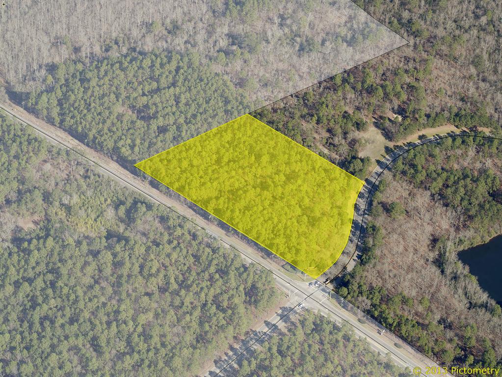
1 Subject Property: Applicant: PLANNING COMMISSION ANNEXATION, COMPREHENSIVE PLAN MAP AMENDMENT, AND ZONING MAP AMENDMENT CASE SUMMARY 385 SPEARS CREEK CHURCH ROAD ANNEX, ASSIGN LAND USE CLASSIFICATION UEMF (URBAN EDGE MULTI-FAMILY) AND ZONE PROPERTY PUD-R (PLANNED UNIT DEVELOPMENT - RESIDENTIAL) September 14, 2015 at 4:00pm City Council Chambers, 3 rd Floor, 1737 Main Street, Columbia, SC Spears Creek Church Road, TMS# (p) Woodcreek Development, LLC Council District: 4 Census Tract: County Land Use Plan: Neighborhood Proposed Land Use Plan: UEMF (Urban Edge Multi-Family) County Zoning: PDD Proposed Zoning: PUD-R Current Land Use: Undeveloped Proposed Use: Multi-Family Reason for Annexation: Donut Hole, Owner Requests City Sewer Services Staff Recommendation: Annex, assign UEMF Land Use Classification and PUD-R Zoning CASE HISTORY Planning Commission: 09/14/15 Richland County PDD to PUD-R PENDING APPLICATION REQUEST Applicant is requesting annexation in order to connect and receive City services. City services are currently available to the property. CURRENT PARCEL CHARACTERISTICS/CONDITIONS The subject parcel is 5.13 acres and located on the north corner of Spears Creek Church Road and Woodcreek Farms Road. Only a portion of this parcel is currently being annexed. PLANS, POLICIES, AND LAND USE Urban Service Area Subject parcel is in a Donut Hole as identified in the Urban Service Area Map Principles and Goals of the Urban Service Area 1
2 The Urban Service Area identifies those areas it wishes to provide with urban services. Primary emphasis will be given to annexing developed areas adjoining the city limits and islands of unincorporated territory surrounded by the city. Primary, secondary, and long-range annexation priorities for specific areas may be identified. Secondary areas may include higher value properties which assist the City in achieving a more balanced economic base. Donut Holes are unincorporated areas that are completely surrounded by the City of Columbia and/or another municipality. These areas pose a number of challenges to the City that can be addressed through annexation. They can often cause inefficiencies in the delivery of services due to confusion about jurisdiction. Also, if the land is in a jurisdiction with a different approach to code enforcement, these areas can negatively impact the quality of life for adjacent City residents. Such inefficiencies and the costs to taxpayers are germane to City and County property both, which results in a greater impact to City residents since they pay City and County taxes. The Columbia Plan 2018: Comprehensive Plan Land Use Classification Staff recommends subject parcel be designated Urban Edge Multi-Family (UEMF) in The Columbia Plan 2018 Future Land Use Map. Urban Core Multi-family is primarily a single-use infill or redevelopment type consisting of multi-family subdivisions in the core areas of the city. The development is most common after They are characterized by the subdivision of partial or whole blocks within core neighborhoods for redevelopment with multiple multifamily buildings. The buildings in these developments should address the existing city streets and new streets should be designed to continue the grid network found in the adjacent areas. They may include shared community facilities like pools, clubhouses, and recreation centers. Primary Types: Multi-family high-rise Multi-family small to large Secondary Types: Single-family attached Multi-family small to large mixed use Tertiary Types: Small format business/employment Small format civic/institutional Parking structures and lots PROPOSED ZONING DISTRICT SUMMARY The parcel is currently zoned PDD (Planned Development) in Richland County. The surrounding lots are zoned PUD-R (Planned Unit Development, Residential), C-1 (Office and nstitutional), and RG-2 (General Residential, High Density) in the City of Columbia. The intent of planned unit development districts is to derive the benefits of efficiency, economy and flexibility by encouraging unified development of large sites. It is the intent of this article to allow development of large sites subject to specific regulations concerning permitted uses, but only subject to regulations concerning lot area, building coverage, yard spaces and building height insofar as the ity ouncil shall deem appropriate to fulfill the intent of this article, upon presentation of certification from the owners, developers or other parties at interest in the development of such sites that they will adhere to development policies which will fulfill the intent of this article. The PUD-R district is intended to accommodate residential uses, with nonresidential uses integrated into the design of such districts as secondary uses. STAFF RECOMMENDATION Recommend approval of resolution assigning UEMF land use classification. Recommend to City Council the adoption of an ordinance assigning UEMF land use classification and recommendation to City Council to apply PUD-R zoning. 2
3

4 Future Land Use Map Department of Planning & Development Services Legend CITY LIMITS PARCELS NE/S Spearks Creek Church Road TMS# (p) FLU: UEMF UCMR-1 - Urban Core Mixed Residential-1 UCMR-2 - Urban Core Mixed Residential-2 UEMR - Urban Edge Mixed Residential UEMF - Urban Edge Multi-Family UCR-1 - Urban Core Residential Small Lot UCR-2 - Urban Core Residential Large Lot UER-1 - Urban Edge Residential Small Lot UER-2 - Urban Edge Residential Large Lot SUBJECT PARCEL UCAC-1 - Urban Core Neighborhood Activity Center UCAC-2 - Urban Core Community Activity Center UEAC-1 Urban Edge Community Activity Center UCAC-3 Urban Core Regional Activity Center UEAC-2 - Urban Edge Regional Activity Center WOODCREEK FARMS AC-1 - Neighborhood Activity Corridor AC-2 - Community Activity Corridor AC-3 - Regional Activity Corridor EC - Employment Campus IND - Industrial SPEARS CREEK CHURCH UER-2 TU - Transportation & Utilities SD-1 - Sports/Amusement District SD-2 - Civic/Institutional Districts SD-3 - Central Business District A c r e s SD-4 - Riverbanks Zoo and Garden SD-5 - Universities/Colleges SD-6 - Fort Jackson I Feet ORIGINAL PREPARATION/DATE: This map was prepared by: D. Eisenbraun July 11, 2015 UEMF EARTH CITY OF COLUMBIA PLANNING DEPARTMENT THIS MAP IS THE PRODUCT OF COMPILATION, OR WAS PRODUCED BY OTHERS. IT IS FOR INFORMATION ONLY AND THE CITY OF COLUMBIA MAKES NO REPRESENTATIONS AS TO ITS ACCURACY OR USE WITHOUT FIELD VERIFICATION IS AT THE SOLE RISK OF THE USER. UEAC-1 ** DATA SOURCE - CITY OF COLUMBIA, GIS DIVISION

5 Zoning Map Department of Planning & Development Services Legend CITY LIMITS PARCELS PENDING ANNEXATION NE/S Spearks Creek Church Road TMS# (p) ZONED: PDD - FP - FP D-1 C-1 RS-1 RS-1A RS-1B C-2 C-3 C-3A RG-2 RS-2 C-4 RS-3 RD RD-2 C-5 M-1 M-2 - FP SUBJECT PARCEL RG-1 PUD-C RG-1A PUD-LS RG-2 PUD-LS-E RG-3 PUD-LS-R UTD MX-1 MX-2 PUD-R OUT OF CITY Ft Jackson Overlay I Feet ORIGINAL PREPARATION/DATE: This map was prepared by: A c r e s WOODCREEK FARMS PUD-R D. Eisenbraun July 28, 2015 C-1 DISCLAIMER: The City of Columbia Department of Planning and Development Services data represented on this map or plan is the product of compilation, as produced by others. It is provided for informational purposes only and the City of Columbia makes no representation as to its accuracy. Its use without field verification is at the sole risk of the user. M-1 RG-2 SPEARS CREEK CHURCH EARTH C-2 C-3 PEACH GROVE PUD-R PUD-C ** DATA SOURCE - CITY OF COLUMBIA, GIS DIVISION
6 A RESOLUTION OF THE CITY OF COLUMBIA PLANNING COMMISSION RES: COMP PLAN RECOMMENDING AMENDING THE CITY OF COLUMBIA COMPREHENSIVE PLAN 2018 FUTURE LAND USE MAP TO INCLUDE THE PROPERTY AT 385 SPEARS CREEK CHURCH ROAD INTO THE CITY OF COLUMBIA. WHEREAS, the City of Columbia and community at large recognize the value of planning for future development and growth; and, WHEREAS, City Council approved Ordinance No.: on October 1, 2008 adopting the City of Columbia Comprehensive Plan (The Columbia Plan 2018) in accordance with the South Carolina Comprehensive Planning Act of 1994 (Title 6, Chapter 29 of the SC Code); and, WHEREAS, City Council approved Ordinance No.: on February 17, 2015 amending the City of Columbia Comprehensive Plan 2018 deleting the "Existing and Future Land Use Components of the Physical Area Development Element of The Columbia Plan: 2018" and replaced it with "Plan Columbia Land Use Plan Putting the Pieces Together", along with all the maps and policies contained therein; and, WHEREAS, 385 Spears Creek Church Road filed for petition July 29, 2015 and was not included within Plan Columbia Land Use Plan Putting the Pieces in Place adopted by City Council on February 17, 2015, and shall be assigned the designated future land use classifications of Urban Edge Multi-Family, and the Future Land Use Map shall be amended accordingly; and, WHEREAS, the City of Columbia Planning Commission has provided input and recommendations in response to the public input and findings; NOW, THEREFORE BE IT RESOLVED by the City of Columbia Planning Commission this, the Fourteenth day of September, 2015, that the property to be annexed at 385 Spears Creek Church Road, be assigned the designated future land use classifications of Urban Edge Multi-Family, and the Future Land Use Map be amended accordingly, along with all the maps and policies contained therein is recommended for adoption to City Council. Richard H. Cohn, Sr. Planning Commission Chairman Date
PLANNING COMMISSION ANNEXATION, COMPREHENSIVE PLAN MAP AMENDMENT, AND ZONING MAP AMENDMENT CASE SUMMARY
 PLANNING COMMISSION ANNEXATION, COMPREHENSIVE PLAN MAP AMENDMENT, AND ZONING MAP AMENDMENT CASE SUMMARY 7316, 7320, 7324, AND 7340 GARNERS FERRY ROAD ANNEX, ASSIGN LAND USE CLASSIFICATION AC-2 (COMMUNITY
BOARD OF ZONING APPEALS CASE SUMMARY FOR VARIANCE REQUEST. 707 Catawba Street
 BOARD OF ZONING APPEALS CASE SUMMARY FOR VARIANCE REQUEST 707 Catawba Street November 8, 2016 at 10:00 A.M. City Council Chambers, 1737 Main Street, 3 rd Floor Columbia, South Carolina Case Number: 16-065-V
BOARD OF ZONING APPEALS CASE SUMMARY FOR VARIANCE REQUEST. 325 Veterans Road
 BOARD OF ZONING APPEALS CASE SUMMARY FOR VARIANCE REQUEST 325 Veterans Road April 11, 2017 at 10:00 A.M. City Council Chambers, 1737 Main Street, 3 rd Floor Columbia, South Carolina Case Number: 2017-0031-V
Public Hearing July 17, 2012 Eau Claire Print Building, 3907 Ensor Avenue Columbia, South Carolina
 COLUMBIA CITY COUNCIL ANNEXATION WITH MAP AMENDMENT CASE SUMMARY 5005 WOODBRIER STREET ANNEX AND ZONE PROPERTY RG-2 AND PORTION OF 5001 WOODBRIER STREET ANNEX AND ZONE PROPERTY RS-3 Public Hearing July
CITY COUNCIL ANNEXATION CASE SUMMARY 941 SPEARS CREEK COURT ANNEX AND ASSIGN M-1 INTERIM ZONING
 CITY COUNCIL ANNEXATION CASE SUMMARY 941 SPEARS CREEK COURT ANNEX AND ASSIGN M-1 INTERIM ZONING 1 st Reading May 8, 2012 City Council Chambers, 3 rd Floor, City Hall, 1737 Main Street Columbia, South Carolina
PLANNING COMMISSION MAP AND TEXT AMENDMENT CASE SUMMARY
 PLANNING COMMISSION MAP AND TEXT AMENDMENT CASE SUMMARY REZONE FROM RS-1 (SINGLE FAMILY RESIDENTIAL) TO RS-1, -DP (SINGLE FAMILY RESIDENTIAL, DESIGN PRESERVATION) AT 730 BELTLINE BOULEVARD January 6, 2014
CITY COUNCIL TEXT AMENDMENT CASE SUMMARY
 CITY COUNCIL TEXT AMENDMENT CASE SUMMARY AMEND THE PRIVATE DORMITORY ORDINANCE, SECTION 17-321, TO PERMIT THE USE WITH CONDITIONS IN THE C-3 (GENERAL COMMERCIAL) ZONING DISTRICT Public Hearing November
RICHLAND COUNTY COUNCIL ZONING PUBLIC HEARING
 RICHLAND COUNTY COUNCIL ZONING PUBLIC HEARING MAY 27, 2014 RICHLAND COUNTY COUNCIL ZONING PUBLIC HEARING MAY 27, 2014 SC 215 Joyce Dickerson 176 Bill Malinowski 21 26 Torrey Rush Julie Ann Dixon!( Jim
Findings and Recommendations of the Dover Planning Commission And Annexation Report Information
 PETITION FOR Annexation Plan Amendment to Comprehensive Plan Update 2003 and PETITION TO ANNEX AND ZONE PROPERTY Before The Dover City Council November 8, 2004 Owner: Equitable Owner: Location: Tax Map
BOARD OF ZONING APPEALS CASE SUMMARY FOR SPECIAL EXCEPTION. NX 900 Greenlawn Drive
 BOARD OF ZONING APPEALS CASE SUMMARY FOR SPECIAL EXCEPTION NX 900 Greenlawn Drive January 9, 2018 at 10:00 A.M. City Council Chambers, 1737 Main Street, 3 rd Floor Columbia, South Carolina Case Number:
THE AREA PLAN COMMISSION OF ST. JOSEPH COUNTY, IN AGENDA
 THE AREA PLAN COMMISSION OF ST. JOSEPH COUNTY, IN AGENDA Tuesday, June 20, 2017 Fourth-Floor Council Chambers 3:30 p.m. County-City Building, South Bend, IN PUBLIC HEARINGS: 1. Rezonings: A. A combined
Indicates Council-recommended changes Introduced by: Mr. Tackett Date of introduction: June 14, 2016 SUBSTITUTE NO. 1 TO ORDINANCE NO.
 Indicates Council-recommended changes Introduced by: Mr. Tackett Date of introduction: June 14, 2016 SUBSTITUTE NO. 1 TO ORDINANCE NO. 16-067 TO AMEND NEW CASTLE COUNTY CODE CHAPTER 40 (ALSO KNOWN AS THE
CONTRA COSTA LOCAL AGENCY FORMATION COMMISSION EXECUTIVE OFFICER'S REPORT August 12, 2015 (Agenda)
") CONTRA COSTA LOCAL AGENCY FORMATION COMMISSION EXECUTIVE OFFICER'S REPORT PROPONENTS ACREAGE & LOCATION Laurel Place/Pleasant View Annexation to the City of Concord Curt Blomstrand, Lenox Homes landowner/petitioner
CONTRA COSTA LOCAL AGENCY FORMATION COMMISSION EXECUTIVE OFFICER'S REPORT PROPONENTS ACREAGE & LOCATION Laurel Place/Pleasant View Annexation to the City of Concord Curt Blomstrand, Lenox Homes landowner/petitioner
ORDINANCE NO day of September, 1983, the Board of. County Commissioners did adopt Ordinance 83-19, an Ordinance
 ORDINANCE NO 85-14 AN ORDINANCE AMENDING ORDINANCE NO. 83-19. THIS ORDINANCE RE-ZONES AND,RE-CLASSIFIES THE PROPERTY HEREIN AFTER DESCRIBED, IN NASSAU COUNTY, FLORIDA, ON THE SOUTH END OF AMELIA ISLAND,
CITY OF PAPILLION PLANNING COMMISSION STAFF REPORT MAY 27, 2015 AGENDA REVISE ZONING MAP MISC
 PLANNING COMMISSION STAFF REPORT MAY 27, 2015 AGENDA REVISE ZONING MAP MISC-15-0006 I. GENERAL INFORMATION A. APPLICANT: City of Papillion 122 East Third St. Papillion, NE 68046 B. REQUESTED ACTION: Approval
ITEM #6 & 6A. Application #LEGP
 CHANGE OF ZONING FROM SR LOW DENSITY SINGLE FAMILY SUBURBAN RESIDENTIAL TO R2/PD LOW TO MODERATE DENSITY RESIDENTIAL/PLANNED DEVELOPMENT AND APPROVAL OF A PRELMINARY DEVELOPMENT PLAN Application #LEGP-001557-2014
Planning Department Oconee County, Georgia
 Planning Department Oconee County, Georgia STAFF REPORT REZONE CASE #: 6985 DATE: October 31, 2016 STAFF REPORT BY: Andrew C. Stern, Planner APPLICANT NAME: Williams & Associates, Land Planners PC PROPERTY
LAND USE ASSUMPTIONS REPORT POTENTIAL FUTURE DEVELOPMENT WEST WHITELAND TOWNSHIP, CHESTER COUNTY, PA
 LAND USE ASSUMPTIONS REPORT POTENTIAL FUTURE DEVELOPMENT WEST WHITELAND TOWNSHIP, CHESTER COUNTY, PA Adopted June 17, 2015 by Township Resolution No. 2015-30 Prepared by Theurkauf Design & Planning, LLC
Buildable Lands Analysis within the Overall UGB Expansion Process
 CHAPTER 3. BUILDABLE LANDS ANALYSIS The buildable lands inventory is intended to identify lands that are available for development within the UGB. The inventory is sometimes characterized as supply of
The summary of zoning regulations for each site is provided in the same order (and using the same names for each site) as the RFEI.
 as the RFEI.") Lincoln City Zoning/regulatory Overview This paper provides a summary of zoning regulations for the eight properties included in Lincoln City s Request for Expressions of Interest (RFEI). The complete
Lincoln City Zoning/regulatory Overview This paper provides a summary of zoning regulations for the eight properties included in Lincoln City s Request for Expressions of Interest (RFEI). The complete
CONTRA COSTA LOCAL AGENCY FORMATION COMMISSION EXECUTIVE OFFICER'S REPORT. May 12, 2010 (Agenda)
") CONTRA COSTA LOCAL AGENCY FORMATION COMMISSION EXECUTIVE OFFICER'S REPORT LAFCO 10-01: Annexation 174 to Central Contra Costa Sanitary District (CCCSD) PROPONENT: CCCSD by Resolution No. 2009-027 adopted
CONTRA COSTA LOCAL AGENCY FORMATION COMMISSION EXECUTIVE OFFICER'S REPORT LAFCO 10-01: Annexation 174 to Central Contra Costa Sanitary District (CCCSD) PROPONENT: CCCSD by Resolution No. 2009-027 adopted
PLANNING COMMISSION Thursday, September 5, :00 p.m. Council Chambers, Administration Building 100 Ribaut Road, Beaufort, South Carolina
 PLANNING COMMISSION Thursday, September 5, 2013 6:00 p.m. Council Chambers, Administration Building 100 Ribaut Road, Beaufort, South Carolina In accordance with South Carolina Code of Laws, 1976, Section
Load Growth Matters May 24, 2018
 Load Growth Matters May 24, 2018 Territorial Act Review Peter Floyd 2 Disclaimer This presentation of the Georgia Territorial Act is a overview of many areas of the Act that apply to many cities. The presentation
Future Land Use Categories & Nodes December 23, Future Land Use Categories
 Future Land Use Categories & Nodes December 23, 2015 A note regarding nodes: Descriptions for nodes are located in the general recommendations handout. Node locations are set in part by the Auburn Interactive
Planning Department Oconee County, Georgia STAFF REPORT
 Planning Department Oconee County, Georgia STAFF REPORT REZONE CASE #: 7332 DATE: November 28, 2017 STAFF REPORT BY: Gabriel Quintas, Planner APPLICANT NAME: Smith Planning Group PROPERTY OWNER: John Hadden
COUNTY OF LINCOLN, NORTH CAROLINA
 COUNTY OF LINCOLN, NORTH CAROLINA 302 NORTH ACADEMY STREET, SUITE A, LINCOLNTON, NORTH CAROLINA 28092 PLANNING AND INSPECTIONS DEPARTMENT 704-736-8440 OFFICE 704-732-9010 FAX To: George Wood, county manager
CONTRA COSTA LOCAL AGENCY FORMATION COMMISSION EXECUTIVE OFFICER'S REPORT. January 8, 2014 (Agenda)
") CONTRA COSTA LOCAL AGENCY FORMATION COMMISSION EXECUTIVE OFFICER'S REPORT : Rodeo Marina Annexation to Rodeo Sanitary District (RSD) PROPONENT: RSD by Resolution No. 2011-01 adopted April 12, 2011 ACREAGE
CONTRA COSTA LOCAL AGENCY FORMATION COMMISSION EXECUTIVE OFFICER'S REPORT : Rodeo Marina Annexation to Rodeo Sanitary District (RSD) PROPONENT: RSD by Resolution No. 2011-01 adopted April 12, 2011 ACREAGE
PALM BEACH COUNTY PLANNING, ZONING AND BUILDING DEPARTMENT ZONING DIVISION ZONING COMMISSION VARIANCE STAFF REPORT 8/5/2010
 PALM BEACH COUNTY PLANNING, ZONING AND BUILDING DEPARTMENT ZONING DIVISION ZONING COMMISSION VARIANCE STAFF REPORT 8/5/2010 APPLICATION NO. CODE SECTION REQUIRED PROPOSED VARIANCE ZV-2010-00658 V1 3.E.1.C.2.a.1
PLANNING COMMISSION REPORT Regular Agenda - Public Hearing Item
 Z-15-00469 Item No. 6A- 1 PLANNING COMMISSION REPORT Regular Agenda - Public Hearing Item PC Staff Report 11/16/15 ITEM NO. 6A GPI, RM12, & RS40 TO RM12; 14.756 ACRES; 5200 & 5300 CLINTON PKWY (SLD) Z-15-00469:
ARTICLE 3: Zone Districts
 ARTICLE 3: Zone Districts... 3-1 17.3.1: General...3-1 17.3.1.1: Purpose and Intent... 3-1 17.3.2: Districts and Maps...3-1 17.3.2.1: Applicability... 3-1 17.3.2.2: Creation of Districts... 3-1 17.3.2.3:
Metropolitan Planning Commission. DATE: April 5, 2016
 TO: FROM: Metropolitan Planning Commission MPC Staff DATE: April 5, 2016 SUBJECT: Petition of Nine Line Inc. Robert McCorkle, Agent PIN: 2-1034-01-002 380.5 Acres Aldermanic District: 5 (Shabazz) County
PROPERTY EVALUATION: HWY 82, OLD SNOWMASS CONOCO
 PROPERTY EVALUATION: 26800 HWY 82, OLD SNOWMASS CONOCO Date: 7/30/2018 Address: 26800 Hwy 82(Snowmass Conoco) Zoning: B-2 General Business Jurisdiction: Pitkin County Area: 1.66 Acres, 72,449sf Parcel
REZONING APPLICATION INSTRUCTIONS
 REZONING APPLICATION INSTRUCTIONS All required information, as stated on the Rezoning Application Checklist, must be included to qualify as a complete application. Upon receipt, staff will review the application
Appendix S I. H. 20 OVERLAY DISTRICT. LAST UPDATE: December 10, 2013 CASE NUMBER: TA ORDINANCE Number
 Appendix S I. H. 20 OVERLAY DISTRICT LAST UPDATE: December 10, 2013 CASE NUMBER: TA131201 ORDINANCE Number 9655 2013 Unified Development Code Grand Prairie, Texas Planning Department S.1 INTRODUCTION The
RM18 RS9 RM12 RS9 !( S DOCKET #: W3120 PROPOSED ZONING: GB-L EXISTING ZONING: HB-S. PETITIONER: Bank of North Carolina for property owned by Same
 DELANE DR DOCKET #: W3120 RM18 BARRY ST PROPOSED ZONING: GB-L RS9 EXISTING ZONING: HB-S IP OLD GREENSBORO RD WALES ST DENVER ST GEORGE BIG REDD CT LOUISE WILSON LN RM12!(DS MOSES LUCAS CT 585' 627' HB-S
Department of Development
 Department of Development Town Government Academy October 1 st, 2013 Fishers Launch Tonight s Agenda Introductions History Tools & Fundamentals Processes Planning Downtown Planning and Redevelopment 2
RESOLUTION NO ( R)
") RESOLUTION NO. 2013-06- 088 ( R) A RESOLUTION OF THE CITY COUNCIL OF THE CITY OF McKINNEY, TEXAS, APPROVING THE LAND USE ASSUMPTIONS FOR THE 2012-2013 ROADWAY IMPACT FEE UPDATE WHEREAS, per Texas Local
RESOLUTION NO. 2013-06- 088 ( R) A RESOLUTION OF THE CITY COUNCIL OF THE CITY OF McKINNEY, TEXAS, APPROVING THE LAND USE ASSUMPTIONS FOR THE 2012-2013 ROADWAY IMPACT FEE UPDATE WHEREAS, per Texas Local
JOINT RESOLUTION AMENDING JOINT RESOLUTION AS TO ORDERLY ANNEXATION: THE TOWN OF STILLWATER AND CITY OF STILLWATER
 JOINT RESOLUTION AMENDING JOINT RESOLUTION AS TO ORDERLY ANNEXATION: THE TOWN OF STILLWATER AND CITY OF STILLWATER WHEREAS, the Town of Stillwater and the City of Stillwater, Washington County, Minnesota,
FUTURE LAND USE. City of St. Augustine Comprehensive Plan EAR-Based Amendments
 FUTURE LAND USE City of St. Augustine Comprehensive Plan EAR-Based Amendments Future Land Use Element FLU Goal To create an environment within the City and adjacent areas in which its residents have the
Glades County Staff Report and Recommendation Unified Staff Report for Small Scale Plan Amendment and Rezoning
 Glades County Staff Report and Recommendation Unified Staff Report for Small Scale Plan Amendment and Rezoning CASE NUMBERS: COMP17-02 and RZ17-02 DATE of STAFF REPORT: May 1, 2017 CASE TYPE: Application
CONTRA COSTA LOCAL AGENCY FORMATION COMMISSION EXECUTIVE OFFICER'S REPORT. September 15, 2010 (Agenda)
") CONTRA COSTA LOCAL AGENCY FORMATION COMMISSION EXECUTIVE OFFICER'S REPORT : Northeast Area Annexation to Delta Diablo Sanitation District (DDSD) PROPONENT: City of Pittsburg Resolution No. 09-11357 adopted
CONTRA COSTA LOCAL AGENCY FORMATION COMMISSION EXECUTIVE OFFICER'S REPORT : Northeast Area Annexation to Delta Diablo Sanitation District (DDSD) PROPONENT: City of Pittsburg Resolution No. 09-11357 adopted
TO ASSIGN ALL RIGHTS, TITLE AND INTEREST IN AND TO A PORTION OF THAT CERTAIN UNCODIFIED ORDINANCE TO THE CODE OF THE COUNTY OF SPARTANBURG NO
 NO. O-6- AN ORDINANCE TO ASSIGN ALL RIGHTS, TITLE AND INTEREST IN AND TO A PORTION OF THAT CERTAIN UNCODIFIED ORDINANCE TO THE CODE OF THE COUNTY OF SPARTANBURG NO. O-3-33 CERTIFYING A PORTION OF DRAYTON
PALM BEACH COUNTY PLANNING, ZONING AND BUILDING DEPARTMENT ZONING DIVISION
 PALM BEACH COUNTY PLANNING, ZONING AND BUILDING DEPARTMENT ZONING DIVISION Application No.: Z-2016-00663 Application Name: Autism School Control No.: 2014-00133 Applicant: Dayna2, LLC Owners: Dayna2, LLC
City of Columbia ENgiNEEriNg regulations Part 12: application For NEW WatEr service table of CoNtENts Paragraph Description Page No.
 City of Columbia Engineering Regulations PART 12: APPLICATION FOR NEW WATER SERVICE Table of Contents Paragraph Description Page No. 12.1 General 12-1 12.2 Agencies Assigning Street Numbers 12-1 12.3 Required
PLANNED UNIT DEVELOPMENT (PUD)
") SECTION 38.01. ARTICLE 38 PLANNED UNIT DEVELOPMENT (PUD) Purpose The purpose of this Article is to implement the provisions of the Michigan Zoning Enabling Act, Public Act 110 of 2006, as amended, authorizing
SECTION 38.01. ARTICLE 38 PLANNED UNIT DEVELOPMENT (PUD) Purpose The purpose of this Article is to implement the provisions of the Michigan Zoning Enabling Act, Public Act 110 of 2006, as amended, authorizing
1. Roll Call. 2. Minutes a. September 26, 2016 Regular Meeting. 3. Adoption of the Agenda. 4. Visitors to Be Heard
 1. Roll Call City of Vermillion Planning Commission Agenda 5:30 p.m. Regular Meeting Tuesday, October 11, 2016 Large Conference Room 2 nd Floor City Hall 25 Center Street Vermillion, SD 57069 2. Minutes
CITY OF PAPILLION PLANNING COMMISSION STAFF REPORT MAY 31, 2017 AGENDA REVISE ZONING MAP 2017 ANNEXATION NO. 2 MISC
 I. GENERAL INFORMATION A. APPLICANT: 122 East Third St. Papillion, NE 68046 CITY OF PAPILLION PLANNING COMMISSION STAFF REPORT MAY 31, 2017 AGENDA REVISE ZONING MAP 2017 ANNEXATION NO. 2 MISC-17-0005 B.
STAFF SUMMARY OF Z17-10 CONDITIONAL ZONING DISTRICT APPLICATION
 STAFF SUMMARY OF Z17-10 CONDITIONAL ZONING DISTRICT APPLICATION APPLICATION SUMMARY Case Number: Z17-10 Request: Conditional B-2 Zoning District in order to expand an existing retail and warehousing business
Northfield, Minnesota Land Development Code
 Northfield, Minnesota Land Development Code August 2, 2011 Revised April 17, 2012 Revised June 19, 2012 Revised April 16, 2013 Revised November 19, 2013 Revised April 7, 2015 Table of Contents Article
ESTES VALLEY STORMWATER MANAGEMENT PROGRAM
 ESTES VALLEY STORMWATER MANAGEMENT PROGRAM Phase I. Stormwater Master Plan Phase II. Stormwater Utility Feasibility Study Board of Realtors Meeting May 3, 2018 Stormwater Master Plan Summary Stormwater
Seaway Plaza FOR SALE N US Highway 1, Fort Pierce FL $1,299,000
 FOR SALE $1,299,000 Property Details PRICE $1,299,000 GROSS INCOME $104,697.72 BUILDING SIZE 19,183 sf BUILDING TYPE Commercial Shopping Center ACREAGE.92 AC Contemporary concrete block plaza has great
Montreal Road District Secondary Plan [Amendment #127, October 9, 2013]
![Montreal Road District Secondary Plan [Amendment #127, October 9, 2013]](/thumbs/72/66783104.jpg "Montreal Road District Secondary Plan [Amendment #127, October 9, 2013]") [Amendment #127, October 9, 2013] 1.0 General The following policies are applicable to the Montreal Road District as set out in Schedule 1. 1.1 District Objectives The objective of this Plan is to guide
[Amendment #127, October 9, 2013] 1.0 General The following policies are applicable to the Montreal Road District as set out in Schedule 1. 1.1 District Objectives The objective of this Plan is to guide
LAFCO APPLICATION NO LINDE CHANGE OF ORGANIZATION TO KEYES COMMUNITY SERVICES DISTRICT
 EXECUTIVE OFFICER S AGENDA REPORT MARCH 27, 2019 TO: FROM: SUBJECT: LAFCO Commissioners Javier Camarena, Assistant Executive Officer LAFCO APPLICATION NO. 2019-01 LINDE CHANGE OF ORGANIZATION TO KEYES
UDO Advisory Committee Meeting #3 August 18, 2011
 UDO Advisory Committee Meeting #3 August 18, 2011 Today s s Agenda Welcome Recap of Meeting #2 Overview of Strategy Statement Overview of Zoning Districts What changes and what stays the same? Break Putting
ORDINANCE City of DeBary Comprehensive Plan Amendments Page 1 of 3
 ORDINANCE 01-15 AN ORDINANCE OF THE CITY COUNCIL OF DEBARY, FLORIDA, AMENDING THE CITY S COMPREHENSIVE PLAN FUTURE LAND USE ELEMENT TEXT AMENDING COMPREHENSIVE PLAN POLICY 5.406 CONCERNING THE SOUTHEAST
PALM BEACH COUNTY PLANNING, ZONING AND BUILDING DEPARTMENT ZONING DIVISION
 PALM BEACH COUNTY PLANNING, ZONING AND BUILDING DEPARTMENT ZONING DIVISION Application No.: W-2014-00288 Application Name: O Reilly Auto Parts Control No.: 2013-00286 Applicant: Hutton Growth Blue Sky
COUNTY OF LINCOLN, NORTH CAROLINA
 COUNTY OF LINCOLN, NORTH CAROLINA 302 NORTH ACADEMY STREET, SUITE A, LINCOLNTON, NORTH CAROLINA 28092 PLANNING AND INSPECTIONS DEPARTMENT 704-736-8440 OFFICE 704-732-9010 FAX To: George Wood County Manager
TOWN OF KIAWAH ISLAND. TOWN COUNCIL PUBLIC HEARING Kiawah Island Municipal Center Council Chambers AGENDA. CalitoOrder: II.
 Ordinance Ordinance TOWN OF KIAWAH ISLAND 21 BEACH WALKER DRIVE KIAWAH ISLAND. Sc 29455 (843) 768-9166 FAX (843) 768-4764 Mayor Craig E. Weaver TOWN COUNCIL PUBLIC HEARING Kiawah Island Municipal Center
RESOLUTIONNO
 RESOLUTIONNO. 128-2017 RESOLUTION ACCEPTING PETITION AND APPROVING ANNEXATION UNDER OA-276 SARTELL/LESAUK TOWNSHIP 389 15th Street North, SARTELL PARCEL #17.09726.0003 WHEREAS, the city of Sartell and
AGENDA ITEM SUMMARY GLADES COUNTY BOARD OF COUNTY COMMISSIONERS
 AGENDA ITEM SUMMARY GLADES COUNTY BOARD OF COUNTY COMMISSIONERS SUBJECT: Case Number COMP17-01, Legend Moto LLC This is a Legislative Hearing. DEPARTMENT REQUEST: The Community Development Department requests
Chapter 2 Land Use. State of Land Use
 Ch2 6/21/2016 1 Chapter 2 Land Use The responsibility of a municipality to manage and regulate land use is rooted in its need to protect the health, safety, and welfare of local citizens. Although only
PROVO CITY MUNICIPAL ANNEXATION GUIDE
 COMMUNITY DEVELOPMENT PROVO CITY MUNICIPAL ANNEXATION GUIDE This guide has been prepared to outline the procedures and requirements of annexing unincorporated territory into Provo City. Annexations are
ARTICLE 3 ZONING DISTRICTS AND ZONING MAP. Table of Contents
 ARTICLE 3 ZONING DISTRICTS AND ZONING MAP Table of Contents 3-1 Establishment of Zoning Districts... 1 A. General Use Zoning Districts... 1 B. Conditional Zoning Districts... 3 C. Overlay Zoning Districts...
Kitsap County Department of Community Development
 Kitsap County Department of Community Development Staff Report and Recommendation Annual Comprehensive Plan Amendment Process for 2018 George s Corner LAMIRD Boundary Adjustment Report Date 7/16/2018 Hearing
A G E N D A. REGULAR MEETING NOVEMBER 12, :00 p.m.
 A G E N D A KERN COUNTY PLANNING COMMISSION Chambers of the Board of Supervisors Kern County Administrative Center 1115 Truxtun Avenue, Bakersfield, California REGULAR MEETING NOVEMBER 12, 2015-7:00 p.m.
RESOLUTION NO CITY OF BONITA SPRINGS, FOR PROCESSING ZONING AND PROVIDING FOR AN
 FLORIDA; CREATING AN ADMINISTRATIVE CODE TO A RESOLUTION OF THE CITY OF BONITA SPRINGS, RESOLUTION NO. 11-073 U:City CIerkDocumentsADMINI5TRATIVE CODESRES-1 1-073-ZONING VERIFICATION LETTER PROCESS.doc
Marion County Board of County Commissioners
 Marion County Board of County Commissioners Date: 12/2/2015 P&Z: 11/30/2015 BCC: 12/16/2015 Item Number 151210SU Type of Application Special Use Permit Request To establish a Clay Electric Co-Operative
TOWN COUNCIL TOWN OF GYPSUM, STATE OF COLORADO ORDINANCE NO. 10 SERIES 2017 AN ORDINANCE AMENDING THE STRATTON FLATS PLANNED UNIT DEVELOPMENT GUIDE
 TOWN COUNCIL TOWN OF GYPSUM, STATE OF COLORADO ORDINANCE NO. 10 SERIES 2017 AN ORDINANCE AMENDING THE STRATTON FLATS PLANNED UNIT DEVELOPMENT GUIDE WHEREAS, the Town of Gypsum, Colorado ( Town ), is a
STANDARDS FOR EVALUATING PROPOSALS
 STANDARDS FOR EVALUATING PROPOSALS Amended by Resolution No. 2011-1; February 2, 2011 Pursuant to Government Code Section 56375, Santa Cruz LAFCO has established standards for the evaluation of proposals.
SUBJECT PARCEL(S) Property Owner(s) TMS Number Approximate Acreage Carolina Park Development, LLC
 Property Owner(s) TMS Number Approximate Acreage Carolina Park Development, LLC") Staff Report Special Planning Commission Meeting November 19, 2014 For reference, the Zoning Code and Land Development Regulations are available online. AGENDA ITEM 5c. SKETCH PLAN APPROVAL REQUEST: Request
Staff Report Special Planning Commission Meeting November 19, 2014 For reference, the Zoning Code and Land Development Regulations are available online. AGENDA ITEM 5c. SKETCH PLAN APPROVAL REQUEST: Request
Appendix A: Guide to Zoning Categories Prince George's County, Maryland
 Appendix A: Guide to Zoning Categories Prince George's County, Maryland RESIDENTIAL ZONES 1 Updated November 2010 R-O-S: Reserved Open Space - Provides for permanent maintenance of certain areas of land
Highland Green Estates Neighbourhood Area Structure Plan
 Highland Green Estates Neighbourhood Area Structure Plan Original Outline Plan approved by Council: March 10, 1997 Outline Plan amended by Council: March 24, 1997 Converted to a Neighbourhood Area Structure
COUNTY OF LINCOLN, NORTH CAROLINA 302 NORTH ACADEMY STREET, SUITE A, LINCOLNTON, NORTH CAROLINA 28092
 COUNTY OF LINCOLN, NORTH CAROLINA 302 NORTH ACADEMY STREET, SUITE A, LINCOLNTON, NORTH CAROLINA 28092 PLANNING AND INSPECTIONS DEPARTMENT 704-736-8440 OFFICE 704-732-9010 FAX To: Alex Patton, Board of
Mount Airy Planning Commission March 26, Staff Report
 Mount Airy Planning Commission March 26, 2018 Staff Report Special Exception Request Mixed Use Development in CC District Recommendation to Board of Appeals CASE MA-A-18-01 Applicant: Location: Zoning:
3210 Fernandina Rd, Columbia, SC 29210
 445 - W i M R e a l ( B 407 - COMMERCIAL PROPERTY REPORT 3210 Fernandina Rd, Columbia, SC 29210 P r e s e n t e d b y Thomas Webb REALTOR South Carolina Real Estate License: 100704 W o rk : ( 803 ) 5456
COUNTY OF LINCOLN, NORTH CAROLINA
 COUNTY OF LINCOLN, NORTH CAROLINA 302 NORTH ACADEMY STREET, SUITE A, LINCOLNTON, NORTH CAROLINA 28092 PLANNING AND INSPECTIONS DEPARTMENT 704-736-8440 OFFICE 704-732-9010 FAX To: Alex Patton, Board of
2013 APPLICATION FOR URBAN GROWTH AREA AMENDMENT TO PIERCE COUNTY COMPREHENSIVE PLAN
 2013 APPLICATION FOR URBAN GROWTH AREA AMENDMENT TO PIERCE COUNTY COMPREHENSIVE PLAN An Urban Growth Area Amendment (UGA) is a proposed change or revision to the designated Comprehensive Urban Growth Area
ARTICLE 15 - PLANNED UNIT DEVELOPMENT
 Section 15.1 - Intent. ARTICLE 15 - PLANNED UNIT DEVELOPMENT A PUD, or Planned Unit Development, is not a District per se, but rather a set of standards that may be applied to a development type. The Planned
SUBJECT: CONSIDERATION OF CENTRAL PARK VILLAGE BREA ENTITLEMENT DOCUMENTS FOR A PROPOSED MIXED USE PROJECT AT W.
 City of Brea Agenda Item: 18 COUNCIL COMMUNICATION Date: July 17, 2012 TO: FROM: Honorable Mayor and City Council City Manager SUBJECT: CONSIDERATION OF CENTRAL PARK VILLAGE BREA ENTITLEMENT DOCUMENTS
EXHIBIT D. WRITTEN DESCRIPTION For. TOWNSEND VILLAGE PUD December 23, 2015 (Revised)
") I. PROJECT DESCRIPTION EXHIBIT D WRITTEN DESCRIPTION For TOWNSEND VILLAGE PUD December 23, 2015 (Revised) A. This 7.2 acre single-family residential project is located on the East side of Townsend Boulevard,
I. PROJECT DESCRIPTION EXHIBIT D WRITTEN DESCRIPTION For TOWNSEND VILLAGE PUD December 23, 2015 (Revised) A. This 7.2 acre single-family residential project is located on the East side of Townsend Boulevard,
HB-S RM8-S RS9 RM18 HB-S RS9 DOCKET #: W2872. PROPOSED ZONING: RM8-S (Child Day Care Center) EXISTING ZONING: RS9 and RM8-S
 EXISTING ZONING: RS9 and RM8-S") 150' 80' RS9 UNIVERSITY PW STANLEYVILLE DR HB-S LB 123' 70' PROPOSED BELTWAY!( RM8-S S 289' NOEL DR 202' NITA AV MILL CREEK DOCKET #: W2872 PROPOSED ZONING: RM8-S (Child Day Care Center) EXISTING ZONING:
150' 80' RS9 UNIVERSITY PW STANLEYVILLE DR HB-S LB 123' 70' PROPOSED BELTWAY!( RM8-S S 289' NOEL DR 202' NITA AV MILL CREEK DOCKET #: W2872 PROPOSED ZONING: RM8-S (Child Day Care Center) EXISTING ZONING:
Subject: Ordinance 1657, Annexation of 3.55 acres of land at 3015 and 3001 Parker Road.
 Agenda Report 2016-12-12-09 Date: December 8, 2016 To: From: Russ Axelrod, Mayor Members, West Linn City Council Jennifer Arnold, Planning Department Through: John Boyd, Interim Community Development Director
Zoning Districts Agriculture Low Density Rural Residential Moderate Density Rural Residential High Density Rural Residential Manufactured Home Park
 Zoning 201 Zoning Districts Agriculture Low Density Rural Residential Moderate Density Rural Residential High Density Rural Residential Manufactured Home Park Commercial Lakeside Commercial Rural Transitional
Minimum Side Yard** Minor Street, Residential Street, or Marginal Access Street. Access Easement
 Sec. 4-6.1 Development Standards for Dwellings. requirements for lot area and lot width are set forth in the following schedule for each district. Where a district density standard has been established,
COUNTY OF LINCOLN, NORTH CAROLINA
 COUNTY OF LINCOLN, NORTH CAROLINA 302 NORTH ACADEMY STREET, SUITE A, LINCOLNTON, NORTH CAROLINA 28092 PLANNING AND INSPECTIONS DEPARTMENT 704-736-8440 OFFICE 704-732-9010 FAX To: Alex Patton, Board of
42-Acre Parcel Rezoning and Master Plan Amendment. Danny Cagle and Patrick Stanley 6301 Duckweed Rd. Lake Worth, FL 33449
 STAFF REPORT CITY OF PARKLAND DEVELOPMENT SERVICES DEPARTMENT Date Prepared: May 2, 2014 I. Petition Description Petition No.: Project Name: Owners: RZ14-001; MPA14-002 42-Acre Parcel Rezoning and Master
RESOLUTION NO. R2010-
 RESOLUTION NO. R2010- A RESOLUTION OF THE CITY OF MANTECA CITY COUNCIL AUTHORIZING SUBMITTAL OF APPLICATION TO THE SAN JOAQUIN LOCAL AGENCY FORMATION COMMISSION IN THE MATTER OF REORGANIZATION, INCLUDING
IN THE OFFICE OF ADMINISTRATIVE HEARINGS CASE NUMBER S SNYDER DEVELOPMENT CORPORATION THIRD ASSESSMENT DISTRICT DATE HEARD: JULY 2, 2014
 IN THE OFFICE OF ADMINISTRATIVE HEARINGS CASE NUMBER 2014-0039-S SNYDER DEVELOPMENT CORPORATION THIRD ASSESSMENT DISTRICT DATE HEARD: JULY 2, 2014 ORDERED BY: DOUGLAS CLARK HOLLMANN ADMINISTRATIVE HEARING
Background. November 15, 2017 Streamside at Heatherwoode PUD-R Rezoning Public Hearing Information Sheet Page 1 City of Springboro, Ohio
 Background and Rezoning Process Summary Proposed Streamside at Heatherwoode Residential Subdivision 1360 South Main Street (SR 741) Rezoning from R-1, Estate-Type Residential District, to PUD-R, Planned
LOCAL AGENCY FORMATION COMMISSION REGULAR MEETING AGENDA. Wednesday, October 13, :00 a.m.
 LOCAL AGENCY FORMATION COMMISSION REGULAR MEETING AGENDA Wednesday, October 13, 2004 9:00 a.m. Board of Supervisors Hearing Room, Room 381B Kenneth Hahn Hall of Administration 500 West Temple Street, Los
Comprehensive Plan 2015 to 2030 STATE OF LAND USE
 Chapter 2 Land Use The responsibility of a municipality to manage and regulate land use is rooted in its need to protect the health, safety, and welfare of local citizens. Although only acting as one section
Second Reading and Adoption of Zone Text Amendment Ordinance 1/15/19
 Second Reading and Adoption of Zone Text Amendment Ordinance LA PALMA CITY COUNCIL JANUARY 15, 2019 1 RECOMMENDATION It is recommended that the City Council conduct the second reading and adopt an Ordinance
COLUMBIA COUNTY BOARD OF COUNTY COMMISSIONERS POST OFFICE BOX 1529 LAKE CITY, FLORIDA
 COLUMBIA COUNTY BOARD OF COUNTY COMMISSIONERS POST OFFICE BOX 1529 LAKE CITY, FLORIDA 32056-1529 COLUMBIA COUNTY SCHOOL BOARD ADMINISTRATIVE COMPLEX 372 WEST DUVAL STREET LAKE CITY, FLORIDA 32055 County
PALM BEACH COUNTY PLANNING, ZONING AND BUILDING DEPARTMENT ZONING DIVISION
 PALM BEACH COUNTY PLANNING, ZONING AND BUILDING DEPARTMENT ZONING DIVISION Application No.: Z2003-094 Control No.: 2003-094 Petitioner: Mark A. & Susan L. Reinhold Owner: Mark A. & Susan L. Reinhold Agent:
REPORT TO THE SHELBY COUNTY PLANNING COMMISSION From the Department of Development Services Planning Services. February 4, 2019
 REPORT TO THE SHELBY COUNTY PLANNING COMMISSION From the Department of Development Services Planning Services February 4, 2019 Case No. Request for Rezoning Approval From E-1 to E-2 SD This is a request
PC Staff Report 11/18/2013 Z Item No. 1-1
 Z-13-00401 Item No. 1-1 PLANNING COMMISSION REPORT Regular Agenda - Public Hearing Item PC Staff Report 11/18/2013 ITEM NO. 1: Z-13-00401 IG (General Industrial) District TO CS (Strip Commercial) District;
PALM BEACH COUNTY PLANNING, ZONING AND BUILDING DEPARTMENT ZONING DIVISION ZONING COMMISSION VARIANCE STAFF REPORT 06/05/2014
 PALM BEACH COUNTY PLANNING, ZONING AND BUILDING DEPARTMENT ZONING DIVISION ZONING COMMISSION VARIANCE STAFF REPORT 06/05/2014 APPLICATION NO. ZV-2013-03120 CODE SECTION REQUIRED PROPOSED VARIANCE (V1)
7224 Nall Ave Prairie Village, KS 66208
 Real Results - Income Package 10/20/2014 TABLE OF CONTENTS SUMMARY RISK Summary 3 RISC Index 4 Location 4 Population and Density 5 RISC Influences 5 House Value 6 Housing Profile 7 Crime 8 Public Schools
MEMORANDUM! AGENDA ITEM #IV.C
 MEMORANDUM AGENDA ITEM #IV.C DATE: DECEMBER 07, 2018 TO: FROM: COUNCIL MEMBERS STAFF SUBJECT: LOCAL GOVERNMENT COMPREHENSIVE PLAN PROPOSED AND ADOPTED AMENDMENT CONSENT AGENDA Pursuant to the 1974 Interlocal
FORA Board Consistency Determinations Summary
 FORA Board Consistency Determinations Summary BOARD ACTION SUMMARIES Occurance (mm/dd/yy) Summary 1997 Approved Consistency of Marina Municipal Airport Redevelopment Plan: 2nd Finding of Consistency with