AGENDA ITEM SUMMARY GLADES COUNTY BOARD OF COUNTY COMMISSIONERS
|
|
|
- Lorin Quinn
- 5 years ago
- Views:
Transcription
1 AGENDA ITEM SUMMARY GLADES COUNTY BOARD OF COUNTY COMMISSIONERS SUBJECT: Case Number COMP17-01, Legend Moto LLC This is a Legislative Hearing. DEPARTMENT REQUEST: The Community Development Department requests approval of Case Number COMP BACKGROUND/SUMMARY OF REPORT: Legend Moto LLC is requesting a change to the Future Land Use Map (FLUM) designation of 3.4 acres from Residential to Commercial. There is a companion rezoning request for a change from Residential Mixed to Commercial General. There is also a special exception request to allow a specialized motor vehicle dealership for off-road recreational vehicles, allterrain vehicles, and four wheelers on the east half of the subject site. The special exception will not be scheduled for a public hearing unless the plan amendment and rezoning are approved. The subject site is located south of U.S. Hwy 27, east of Wagon Trail and west of Saddle Lane. PLANNING AND ZONING BOARD RECOMMENDATION: The Planning and Zoning Board recommended approval of Case Number COMP MOTION FOR APPROVAL: I move to approve adoption of AN ORDINANCE OF THE GLADES COUNTY BOARD OF COUNTY COMMISSIONERS, AMENDING THE GLADES COUNTY COMPREHENSIVE PLAN BY REVISING THE FUTURE LAND USE MAP FROM RESIDENTIAL TO COMMERCIAL FOR 3.4 ACRES OF LAND; CONSISTING OF LOTS 28A, 28B, 29A, AND 29B OF GLADES LITTLE RANCHES, GLADES COUNTY PLAT BOOK 3, PAGE 22; LOCATED ON U.S. HWY 27; PROPERTY OWNER LEGEND MOTO LLC; CASE NUMBER COMP17-01; PROVIDING FOR INCLUSION OF ORDINANCE AND REVISED FUTURE LAND USE MAP IN THE COMPREHENSIVE PLAN; AND PROVIDING FOR AN EFFECTIVE DATE. based on the findings and analysis in the staff report dated April 3, 2017 and findings presented at the public hearing. MOTION FOR DENIAL: I move to deny the adoption of an ordinance amending the Future Land Use Map designation of lots 28a, 28b, 29a, and 29b of Glades Little Ranches Glades County Plat Book 3, Page 22 from Residential to Commercial, Case Number COMP17-01, for the following reasons. Request By: Meeting Date: May 9, 2017 Inga Williams, Comm. Dev. Director Agenda #
2 ORDINANCE AN ORDINANCE OF THE GLADES COUNTY BOARD OF COUNTY COMMISSIONERS, AMENDING THE GLADES COUNTY COMPREHENSIVE PLAN BY REVISING THE FUTURE LAND USE MAP FROM RESIDENTIAL TO COMMERCIAL FOR 3.4 ACRES OF LAND; CONSISTING OF LOTS 28A, 28B, 29A, AND 29B OF GLADES LITTLE RANCHES, GLADES COUNTY PLAT BOOK 3, PAGE 22; LOCATED ON U.S. HWY 27; PROPERTY OWNER LEGEND MOTO LLC; CASE NUMBER COMP17-01; PROVIDING FOR INCLUSION OF ORDINANCE AND REVISED FUTURE LAND USE MAP IN THE COMPREHENSIVE PLAN; AND PROVIDING FOR AN EFFECTIVE DATE. WHEREAS, The Board of County Commissioners of Glades County recognizes the need to plan for orderly growth and development; and WHEREAS, Chapter 163, Florida Statutes, provides for amendments to adopted Comprehensive Plans; and WHEREAS, the County has received and reviewed a Small Scale Plan Amendment application for an amendment to the Future Land Use Map for County s Comprehensive Plan from Legend Moto LLC for property owned by Legend Moto LLC, and WHEREAS, said application being reviewed by the County s Community Development Department and submitted to the Planning and Zoning Board and the Board of County Commissioners with a staff report, which determined such application to be consistent with the Comprehensive Plan and appropriate to the future land uses within the County; and WHEREAS, in a duly noticed public hearing on April 11, 2017, the Glades County Planning and Zoning Board heard the Future Land Use Map amendment and said Board recommended to the Board of County Commissioners that the application be approved; and WHEREAS, in a duly noticed public hearing on May 9, 2017, the Board of County Commissioners gave full and complete consideration of the record, consisting of the Staff Recommendation, the Planning and Zoning Board recommendation, the documents on file with the County and the testimony of all interested parties and has found that that approval of Case# COMP17-01 is consistent with the Glades County Comprehensive Plan; and WHEREAS, the proposed amendment was reviewed in accordance with Chapter , Florida Statutes and no valid objection has been made to the proposed map amendment; and WHEREAS, after due consideration, the Board has found that the requirements and conditions of Chapter 163, Florida Statutes, as they relate to this petition have been met and that is in the best interest of Glades County that the Future Land Use Map be 1 COMP17-01
3 amended. NOW, THEREFORE, BE IT ORDAINED, by the Glades County Board of County Commissioners that: SECTION 1. THIS ORDINANCE shall be known as the Legend Moto LLC Plan Amendment to the Future Land Use Map, COMP17-01 and shall be effective within the County limits of Glades County, Florida. SECTION 2. This Small Scale Plan Amendment to the Comprehensive Plan Future Land Use Map is adopted pursuant to the provisions of Chapter , Florida Statutes. SECTION 3. The real properties identified in Exhibit A, being located south of and adjacent to U.S. 27, which consists of a 3.4± acres, is hereby re-designated on the Future Land Use Map of the Glades County Comprehensive Plan from Residential to Commercial. SECTION 4. It is the intention of the Board of County Commissioners of Glades County, Florida, and it is hereby provided that the provision of this Ordinance and the revision of the Future Land Use Map shall become and made a part of the Glades County Comprehensive Plan. SECTION 5. In the event that any portion of this Ordinance is for any reason held invalid or unconstitutional by any court of competent jurisdiction, such portion shall be deemed a separate, distinct and independent provision, and such holding shall not affect the validity of the remaining portions of this Ordinance. SECTION 6. This ordinance shall be effective in accordance with Chapter , Florida Statutes. The foregoing Ordinance was offered by Commissioner, who moved its adoption. The motion was seconded by Commissioner, and being put to a vote, the vote was as follows: John Ahern Donald Strenth Weston Pryor Timothy Stanley Donna Storter Long [REMAINDER OF PAGE INTENTIONALLY LEFT BLANK] [NEXT PAGE FOR SIGNATURE] COMP
4 PASSED AND DULY ADOPTED by the Board of County Commissioners of Glades County Florida, during a Public Hearing, this 9th day of May, ATTEST: BOARD OF COUNTY COMMISSIONERS GLADES COUNTY, FLORIDA Sandra Brown Clerk of the Circuit Court John Ahern Chairman APPROVED AS TO FORM AND LEGAL SUFFICIENCY Richard W. Pringle County Attorney COMP
5 Exhibit A Lots 28A, 28B, 29A, and 29B, Glades Little Ranches, according to the plat thereof in Plat Book 3, Page 22, Public Records of Glades County, Florida. COMP
")

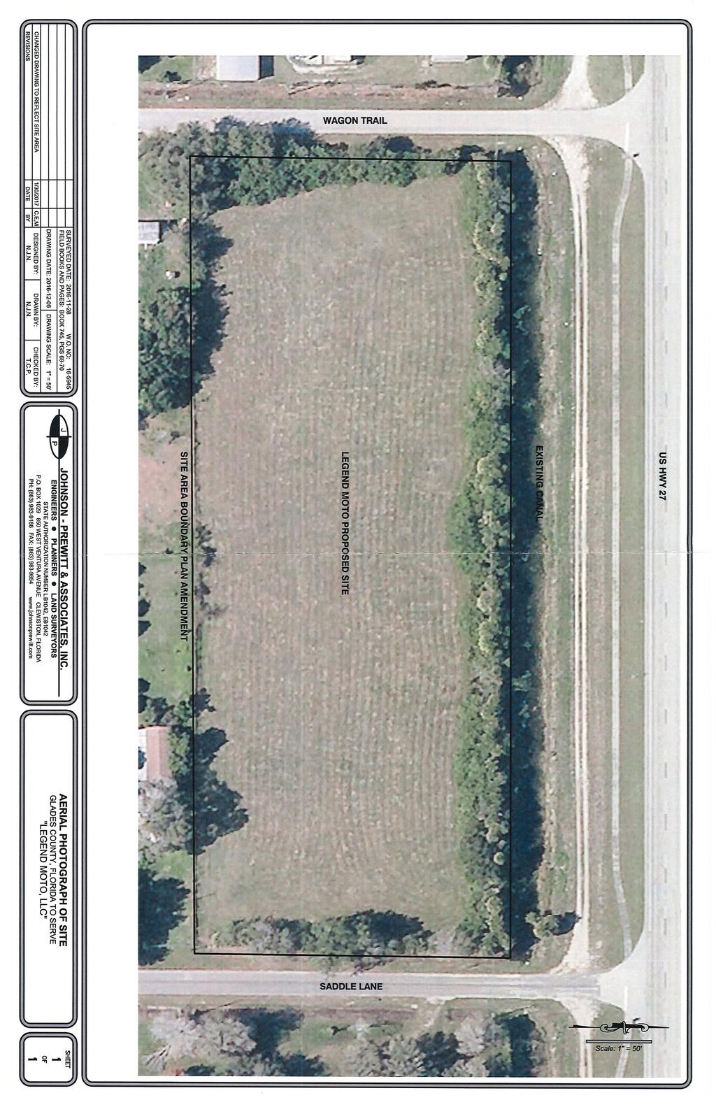
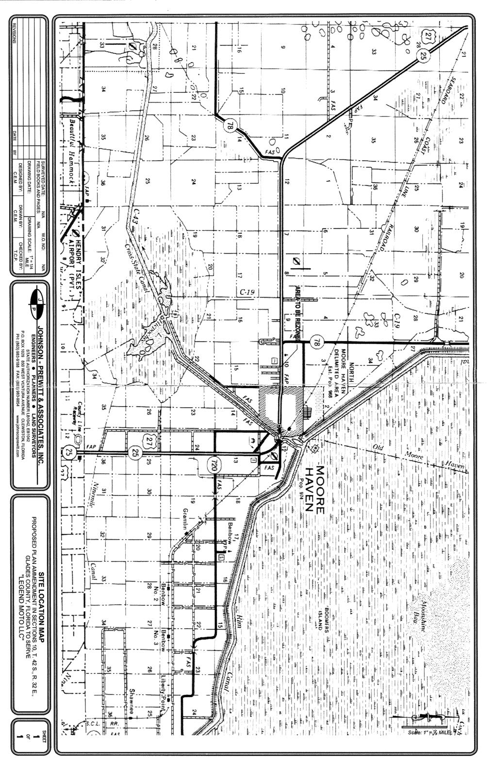
6 Glades County Staff Report and Recommendation Unified Staff Report for Small Scale Plan Amendment and Rezoning CASE NUMBERS: COMP17-01 and RZ17-01 DATE of STAFF REPORT: April 3, 2017 CASE TYPE: Application for a small scale plan amendment to the Future Land Use Map and a rezoning REQUEST: Change the Future Land Use Map (FLUM) designation of 3.4 acres from Residential to Commercial and a Rezoning from Residential Mixed to Commercial General. APPLICANT and PROPERTY OWNER: Legend Moto LLC STAFF RECOMMENDATION: Approval of the plan amendment and rezoning LOCATION: South of U.S. Hwy 27, east of Wagon Trail and west of Saddle Lane. COMP17-01 & RZ17-01, Legend Moto LLC 1
7 I. ZONING DISTRICT DESIGNATIONS A. Current Zoning Designations The Subject Site is zoned Residential Mixed (RM). Surrounding Zoning Districts are Commercial General (C-2), Planned Development (PD), Residential General (RG) and RM. The PD to the right of the subject site allows a church and church related facilities. The PD to the north is for development of an RV Resort with 250 lots and 6.1 acres of mixed commercial along US 27. Hatched area is subject site Residential Mixed (RM) Scope and intent. This section applies to the RM residential mixed district. The residential mixed zoning district permits the continued mixing of conventional residences and mobile homes; however, certain other existing uses, are hereby made nonconforming in an attempt to up-grade and improve such areas. No further property in the county will be zoned RM. To that end, and after the effective date of the ordinance from which these regulations are derived, the county shall accept no application for zoning of property to RM. The RM zoning district boundaries shall remain as shown on the official zoning maps at the date of adoption of the ordinance from which this article is derived unless a portion of such district is changed to another district classification under this article. All new residential construction in RM districts shall meet residential general standards for lot, area and other requirements except use. COMP17-01 & RZ17-01, Legend Moto LLC 2

8 DISTRICT CLASSIFICATION RM Residential Mixed PARCEL AREA DIMENSIONS WIDTH (FT) BUILDABLE UNITS/ACRE SETBACKS (FT) FRONT REAR SIDES MAXIMUM BUILDING HEIGHT (FT) Single family 10,000 sq ft % Duplex 10,000 sq ft % Mobile home 10,000 sq ft % Multifamily 10,000 sq ft % MAXIMUM LOT COVERAGE B. Proposed Zoning Designation Commercial General Scope and intent. This section applies to the C-2 commercial general district. This district is intended to create a mid-level district desirable in situations dealing with uses for which neighborhood commercial is too restrictive. Manufacturing of any type is prohibited. DISTRICT CLASSIFICATION PARCEL AREA BUILDABLE UNITS/ACRE SETBACKS (FT) MAXIMUM BUILDING HEIGHT (FT) DIMENSIONS WIDTH FRONT REAR SIDES (FT) C-2 Commercial General 22,500 sq ft % MAXIMUM LOT COVERAGE COMP17-01 & RZ17-01, Legend Moto LLC 3

9 II. FUTURE LAND USE MAP DESIGNATIONS A. Existing Future Land Use Map The Subject Site is designated Residential. Surrounding designations are Commercial, Institutional, and Residential. Existing Future Land Use Map designation Policy I-1.4F: Land use definitions, densities and intensities of the Future Land Use Map series are as follows: Residential: Land areas used predominantly for housing with density of up to 7 units per acre. Uses may also include low-intensity non-residential uses such as neighborhood commercial uses including restaurants, barber shops, convenient food stores, movie rentals, houses of worship, public parks and plant nurseries; existing cemeteries; private child care centers and nonprofit private clubs of a fraternal or social character. Non residential uses shall develop at an intensity no greater than 0.25 floor area ratio and be buffered from residential uses. All non-residential uses shall be limited to a total amount of 100,000 square feet and shall not exceed 15,000 square feet at any one location for projects that are not associated with a PUD. Neighborhood retail commercial uses shall develop at an intensity no greater than 0.25 F.A.R and locate within 1,000 feet of the intersection of two arterial roads or the intersection of an arterial road and a collector road, and be appropriately buffered from residential uses. COMP17-01 & RZ17-01, Legend Moto LLC 4
10 Projects greater than 150 units shall occur in the form of a Planned Unit Development, be compact, connect to central water and sewer, include a variety of residential units (single family units and multifamily units), and also include the following amenities: parks, and bicycle and pedestrian pathways that are connected in order to promote alternative modes of transportations. Projects greater than 500 units shall also include neighborhood retail uses. B. Proposed Future Land Use Map Proposed Future Land Use Map designation Commercial: Land areas which are predominantly connected with the sale, rental, and distribution of products, or performance of services. Densities shall be up to 24 units an acre for motel units; up to 30 units an acre for recreational vehicles; up to 0.5 floor area ratio for single story structures, with a minimum 0.4 site not covered with impervious surfaces; up to 1.0 floor area ratio for multi-story structures, with a minimum 0.4 site not covered with impervious surfaces. III. EXISTING USES The Subject Site is vacant. The property to the west contains self-storage units. The property to the east is vacant. To the south and southwest are single-family homes. Across U.S. 27 is vacant. COMP17-01 & RZ17-01, Legend Moto LLC 5
11 IV. ANALYSIS OF RELEVANT COMPREHENSIVE PLAN POLICIES Future Land Use Element Policy I-1.3B: Commercial and industrial developments shall be designed to meet the neighborhood, community or regional needs of the residents of Glades County. 1. Commercial rezoning and development will be limited based upon the commercial needs of the residents and the impacts of rezoning on adjacent lands. Additional zoning and development will be approved only upon determination by the Planning and Zoning Board (PZB) that there is a special need, or to meet the needs of transients. 2. Commercial and industrial facilities shall be required to incorporate site design characteristics which aesthetically complement the area within which they are to be located. 3. Commercial and industrial developments shall be reviewed for their impact on support facilities, including, but not limited to, roads, central water, sewage, and fire protection. When new or additional facilities are required, approval for the proposal shall be contingent upon a commitment by the developer to pay a fair share of costs. 4. Actions 1-3, above, will be incorporated into the County s Land Development Code and/or Regulations by the end of Staff Review: This site is located in close proximity to the City of Moore Haven boundary and is a large parcel with 245 feet of depth and 610 feet of frontage on U.S. 27. It provides enough acreage that a commercial center or multiple, single-use commercial business can be constructed. It is near a population center and is accessible from a major arterial road and so could provide services to the County s permanent and transient population. The applicants have submitted a Special Exception request to develop the east half of the property with a retail and wholesale dealership that specializes in off-road recreational vehicles. The remainder of the site could develop with permitted C-2 uses. Design standards and building standards for the site can be incorporated into the Special Exception approval and landscaping standards can be enhanced in order to decrease any adverse impacts on adjacent residential uses. Commercial Design Requirements of Section are as follows: o A site plan indicating proposed uses and structures, driveways and parking areas, yards, buffering, a schedule for initiation and completion of development, and such other details. o Limitations on vehicular access. Except for utility and service vehicles, there shall be no vehicular access to the property through a residential district. o Site planning; limitations on operations. Site planning, design and location of structures and open spaces, and management of operations shall be such that orientation of commercial and related activities is toward the frontage on the street. There shall be no sales, service storage or display of goods or materials and no off-street loading operations, garbage or trash storage, or collection or disposal facilities visible in any portion of the property from any portion of any abutting residential district. Signs on the property shall be oriented away from any abutting residential district. Lighting of structures and premises on the property shall be so directed and shielded as to protect adjoining residential uses from nuisance effects. COMP17-01 & RZ17-01, Legend Moto LLC 6
12 o Yard requirements; buffering. Yards and structural buffering shall be provided to minimize the impact of the development of any abutting residential district. The following minimum requirements may be increased to achieve a stated public purpose, but shall not be diminished: (1) Yards adjacent to streets shall be a minimum of 25 feet in depth. (2) Yards adjoining lot lines in any residential district shall be a minimum of 15 feet in minimum dimension. (3) All yards provided which abut any residential district shall be landscaped and maintained appropriate to the residential surrounds. No portion of any required yard abutting any residential district shall be used for off-street parking. (4) Where necessary to protect adjacent property in residential districts from lights, noise, or undesirable views, appropriate fences or walls may be required to be provided and maintained as required in this chapter. Policy I-1.4B: New development emphasizing employment opportunities and needed retail enterprises shall be located within proximity to Glades residents while meeting all infrastructure requirements. Such developments shall be compatible with and complement the existing architectural design and density of surrounding neighborhoods. 1. The Planning and Zoning Board (PZB) will include employment opportunities, compatibility with the surrounding community, architectural design and density as criteria in its plan review. Staff Review: The property owners are proposing to use the east half of the property for a specialized motor vehicle dealership. They anticipate needing 4 employees for this business. Plan review for the project will occur during the Special Exception review and again, with more detail, at the time a building permit has been submitted. Policy I-1.6A: New land developments adjacent to existing and proposed arterial roads shall provide land for a frontage road or shall design the ingress and egress of the development to minimize the need for multiple access points. 1. The Planning and Zoning Board (PZB) will use this as a criterion in reviewing plans. The County Engineer will review all such proposals and will make recommendations to the PZB. Staff Review: Entry to the site will most likely occur from Saddle Lane as the Department of Transportation does not approve of direct access to highway systems unless there is no other option. Policy I-1.6B: Strip commercial land use adjacent to arterials will be discouraged and mixed-use developments near arterials using cluster techniques will be encouraged. 1. The Planning and Zoning Board (PZB) will only recommend the approval for commercial developments, of sufficient size that enable internal circulation patterns, to developments that minimize the need for multiple access points. Smaller commercial developments should only be recommended for approval if they are located to serve an established neighborhood, or at the intersection of arterial and/or collector roads. The County Engineer will review all such proposals and make recommendations concerning this criterion to the PZB. Staff Review: The definition of strip commercial development from The Latest Illustrated Book of Development Definitions is, Commercial or retail uses, usually one-story high and one-store COMP17-01 & RZ17-01, Legend Moto LLC 7
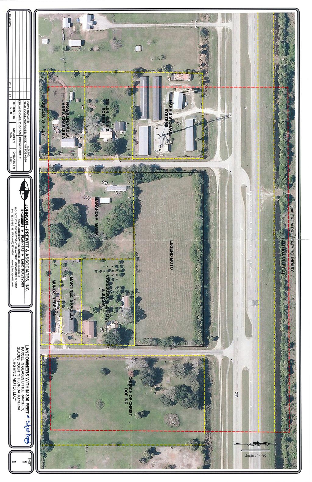
13 deep, that front on a major street. Strip commercial development is typically characterized by street-frontage parking lots serving individual stores or strips of stores. Strip commercial developments differ from central business districts and shopping centers in at least two of the following characteristics: (1) there are no provisions for pedestrian access between individual uses; (2) the uses are only one-store deep; (3) the buildings are arranged linearly rather than clustered; and (4) there is no design integration among individual uses. Developed properties usually identified as strip commercial typically have less depth than this parcel contains, which forces parking to the front of the building. During the Special Exception review, conditions can be applied that will ensure that there is design integration among any developments on the site and pedestrian access between uses. V. ANALYSIS OF REZONING CONSIDERATIONS Buildout Potential Existing potential is 14 Residential Units Potable Water Use: Potable water use is estimated at 125 gallons per capita per day (Infrastructure Element of the Comprehensive Plan). Under current zoning, the property could use 1,750 gallons per day. Traffic generated at 6.65 trips per day for multifamily would be 93± trips per day. Proposed potential is 11,761 square feet of proposed special exception use, plus what could be built on the west half of the property. The applicant s engineer has estimated the usage only using the proposed Specialized Auto Dealership. This could generate 60 gallons per day. This would increase with development of the west half of the property. The applicant s engineer has generated the number of trips per day to the site based on the proposed use, not for development of the entire site. The proposed use could generate 393 average weekday trips per day. U.S. Highway 27 is at a Level of Service A, and the applicant s engineer states that development of this site for commercial will not degrade that level of service. Rezoning Considerations When recommending whether to rezone a classification of land, the factors listed below are used to evaluate the appropriateness of the proposed rezoning, where applicable: # EVALUATION CRITERIA STAFF FINDINGS The proposed change is The proposed zoning is not contrary to the established contrary to the established land land use pattern. The property to the west is zoned use pattern. Commercial General and is developed with a commercial use. The property to the east is zoned Planned 1 Development and is approved for a church use, but is vacant. The land to the north is zoned Planned Development and is approved for an RV Park and commercial center, but is vacant. COMP17-01 & RZ17-01, Legend Moto LLC 8
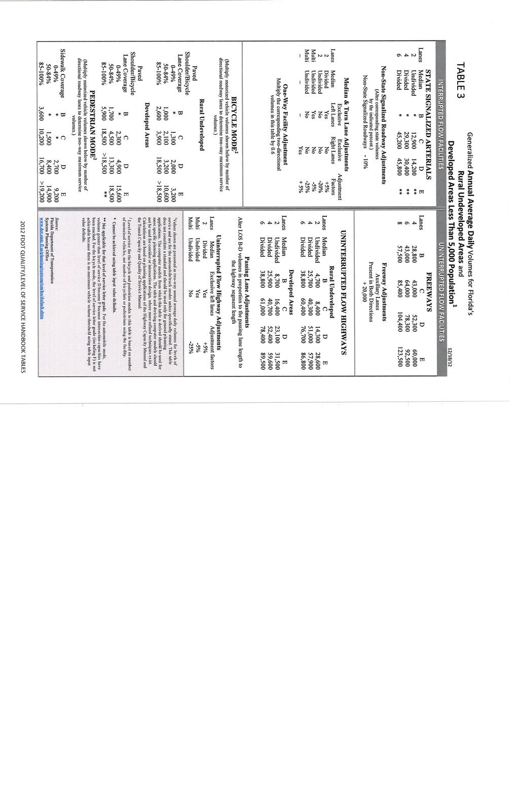
14 Developed residential uses are located south and southwest of the site. These would be most impacted by the proposed development The proposed change would create an isolated district unrelated to adjacent and nearby districts The proposed change would materially alter the population pattern and thereby increase or overtax the load on public facilities, such as schools, utilities, streets, etc. Existing district boundaries are illogically drawn in relation to existing conditions on the property proposed for change. The proposed change would be contrary to the Future Land Use Map and would have an adverse effect on the Comprehensive Plan. Changed or changing conditions made the passage of the proposed amendment necessary. Changed or changing conditions will adversely influence living conditions in the neighborhood. The proposed change will create or excessively increase traffic congestion or otherwise affect public safety. The proposed change will create a drainage problem. The proposed change will seriously reduce light and air to adjacent areas. The proposed change would not create an isolated district unrelated to adjacent and nearby districts. The proposed change is from residential to commercial. The applicant s engineer has indicated no decrease to the Level of Service on U.S. 27. The proposed use would not overtax the water utility. N/A The proposed change will be consistent with the FLUM of Commercial if COMP17-01 is approved by the Board of County Commissioners. A change in the FLUM designation would make the proposed rezoning necessary. An increase of traffic on Saddle Lane or Wagon Trail could adversely influence living conditions for neighboring property owners. Other conditions can be mitigated by enhanced buffering and other site conditions as part of the Special Exception, and also during building permit site plan approval. The traffic report by the applicant s engineer indicates that the proposed use will not create or excessively increase traffic congestion on U.S. 27. Site planning will be required prior to development and any stormwater runoff will be required to be treated on-site. No. COMP17-01 & RZ17-01, Legend Moto LLC 9
15 The proposed change will adversely affect property values in the adjacent area. The proposed change will be a deterrent to the improvement or development of adjacent property in accord with existing regulations. The proposed change will constitute a grant of special privilege to an individual owner as contrasted with the public welfare. There are substantial reasons why the property cannot be used in accord with existing zoning. Whether the change suggested is out of scale with the needs of the neighborhoods or the County. It is impossible to find other adequate sites in the County for the proposed use in districts already permitting such use. Commercial development of the site should not decrease property values in adjacent areas. Commercial development of the site will not be a deterrent to development of a church on the adjacent property. All adjacent residential lots and the majority of neighboring residential lots are already developed. No. There are no substantial reasons why the property cannot be used in accord with existing zoning. No. There are undeveloped C-2 properties nearby. It is unknown whether they would be adequate for the proposed use. The applicant is proposing to change the FLUM designation of 3.4 acres from Residential to Commercial and a change the Zoning District from Residential Mixed to C-2. Although the applicants have submitted a Special Exception, the plan amendment and rezoning must be reviewed as if the property will be developed under the uses currently permitted by the C-2 zoning and current regulations required for commercial development. The subject site is adjacent to a currently developed commercial use on the left, which is mini storage warehouses. The property on the right side is vacant but has approval to develop with a Church and related church uses. Commercial development of the subject site would not prevent this use from developing or impede the use of that property for a church use. To the south of the subject site is a residential neighborhood, and the majority of the properties are already developed. The residential neighborhood would probably be the most impacted by commercial vehicle use at the entrances of either Rodeo Road or Wagon Trail because the subject site will be accessed from one or both of those roads. The safety of residential traffic will need to be addressed by the Florida Department of Transportation when they review plans for this development. Other impacts could affect the adjacent residential uses, such as noise from delivery trucks and the unloading of cargo, and light glare. Landscaping, with a fence or wall, can reduce noise and light glare. COMP17-01 & RZ17-01, Legend Moto LLC 10
16 Shielding and directing lights into the property can reduce light glare. Any opportunity to mitigate impacts to adjacent residential properties will be applied to the development. The property is large enough, with enough depth, for the development of a commercial center and not a strip commercial development. A new commercial center will contribute to the tax base of the County and provide greater employment opportunities for some county residents. VI. RECOMMENDATION The plan amendment and the rezoning are consistent with the Glades County Comprehensive Plan. Staff recommends approval of the plan amendment and the rezoning and respectfully submits this staff report for your review. Inga Williams, AICP Director, Community Development Department COMP17-01 & RZ17-01, Legend Moto LLC 11
17
18
19
20
21
22
23
24
25
26
27
28
29
30
31
32
33
34
35
36
37
38
39
40
41
42
43
44
45
46
47
48
AGENDA ITEM SUMMARY GLADES COUNTY BOARD OF COUNTY COMMISSIONERS
 AGENDA ITEM SUMMARY GLADES COUNTY BOARD OF COUNTY COMMISSIONERS SUBJECT: Case Number COMP17-02, RFYC, LLC This is a Legislative Hearing. DEPARTMENT REQUEST: The Community Development Department requests
Glades County Staff Report and Recommendation Unified Staff Report for Small Scale Plan Amendment and Rezoning
 Glades County Staff Report and Recommendation Unified Staff Report for Small Scale Plan Amendment and Rezoning CASE NUMBERS: COMP17-02 and RZ17-02 DATE of STAFF REPORT: May 1, 2017 CASE TYPE: Application
Glades County Staff Report and Recommendation REZONING
 Glades County Staff Report and Recommendation REZONING CASE NUMBER: RZ15-01 DATE: October 2, 2015 CASE TYPE: Application for Rezoning REQUEST: J.J. Wiggins Memorial Trust is requesting a rezoning of 22.1±
ORDINANCE NO
 ORDINANCE NO. 2016 - AN ORDINANCE OF THE BOARD OF COUNTY COMMISSIONERS OF GLADES COUNTY, FLORIDA, AMENDING THE OFFICIAL ZONING MAP OF GLADES COUNTY FROM RESIDENTIAL SINGLE-FAMILY (RS) AND AGRICULTURAL
Dennis & Donna Blanchard, Agent. Dennis & Donna Blanchard/Disbrow Builders, Inc.
 Nassau County Growth Management Department 96161 Nassau Place Yulee, FL 32097 (904) 491-7328 (904) 491-3611 FAX Date of Hearing: March 3, 2015 Public Hearing Number: R15-001 BOARD MEMBERS Thomas Ford (Chairman)
CITY OF LABELLE ORDINANCE BROWARD AVE LLC PLANNED UNIT DEVELOPMENT REZONE
 CITY OF LABELLE ORDINANCE 2019-04 BROWARD AVE LLC PLANNED UNIT DEVELOPMENT REZONE AN ORDINANCE OF THE CITY OF LABELLE, FLORIDA, AMENDING THE CITY OF LABELLE ZONING MAP FOR PROPERTY LOCATED SOUTH OF BROWARD
UPPER MOUNT BETHEL TOWNSHIP NORTHAMPTON COUNTY, PENNSYLVANIA
 UPPER MOUNT BETHEL TOWNSHIP NORTHAMPTON COUNTY, PENNSYLVANIA JOINDER DEED / LOT CONSOLIDATION TOWNSHIP REVIEW PROCESS When accepting proposed Joinder Deeds / Lot Consolidations, review the Joinder Deed
REPORT OF THE PLANNING AND DEVELOPMENT DEPARTMENT FOR APPLICATION FOR REZONING ORDINANCE TO PLANNED UNIT DEVELOPMENT SEPTEMBER 22, 2016
 BEL REPORT OF THE PLANNING AND DEVELOPMENT DEPARTMENT FOR APPLICATION FOR REZONING ORDINANCE 2016-576 TO PLANNED UNIT DEVELOPMENT SEPTEMBER 22, 2016 The Planning and Development Department hereby forwards
Chapter 1107: Zoning Districts
 Chapter 1107: Zoning Districts 1107.01 Establishment of Zoning Districts (a) Districts Established In order to carry out the purpose of this code, the City is hereby divided into the zoning districts established
Mayor Leon Skip Beeler and Members of the City Commission. Anthony Caravella, AICP, Director of Development Services
 CITY COMMISSION BRIEFING & Planning Board Report For Meeting Scheduled for November 4, 2010 Thousand Island Conservation Area Rezoning Ordinance 1519 FINAL ACTION TO: FROM: THRU: RE: Mayor Leon Skip Beeler
Metropolitan Planning Commission. DATE: April 5, 2016
 TO: FROM: Metropolitan Planning Commission MPC Staff DATE: April 5, 2016 SUBJECT: Petition of Nine Line Inc. Robert McCorkle, Agent PIN: 2-1034-01-002 380.5 Acres Aldermanic District: 5 (Shabazz) County
Midwest City, Oklahoma Zoning Ordinance
 2010 Midwest City, Oklahoma Zoning Ordinance 9/2/2010 Table of Contents Section 1. General Provisions... 5 1.1. Citation... 5 1.2. Authority... 5 1.3. Purpose... 5 1.4. Nature and Application... 5 1.5.
ACTION FORM BRYAN CITY COUNCIL
 ACTION FORM BRYAN CITY COUNCIL DATE OF COUNCIL MEETING: July 8, 2014 DATE SUBMITTED: June 17, 2014 DEPARTMENT OF ORIGIN: Development Services SUBMITTED BY: Maggie Dalton MEETING TYPE: CLASSIFICATION: ORDINANCE:
Planning Department Oconee County, Georgia
 Planning Department Oconee County, Georgia STAFF REPORT REZONE CASE #: 6985 DATE: October 31, 2016 STAFF REPORT BY: Andrew C. Stern, Planner APPLICANT NAME: Williams & Associates, Land Planners PC PROPERTY
Cover Letter with Narrative Statement
 Cover Letter with Narrative Statement March 31, 2017 rev July 27, 2017 RE: Rushton Pointe Residential Planned Unit Development Application for Public Hearing for RPUD Rezone PL2015 000 0306 Mr. Eric Johnson,
INDIAN RIVER COUNTY, FLORIDA. The Honorable Members of the Planning and Zoning Commission DEPARTMENT HEAD CONCURRENCE
 Public Hearing Legislative INDIAN RIVER COUNTY, FLORIDA M E M O R A N D U M TO: The Honorable Members of the Planning and Zoning Commission DEPARTMENT HEAD CONCURRENCE Robert M. Keating, AICP; Community
ALL ORDINANCES IN CONFLICT HEREWITH; PROVIDING FOR AN EFFECTIVE DATE.
 ORDINANCE 2013-07 AN ORDINANCE AMENDING THE CODE OF ORDINANCES OF THE TOWN OF LONGBOAT KEY, FLORIDA, BY AMENDING THE ZONING CODE, DIVISION 3, COMMERCIAL REVITALIZATION, CHAPTER 158.180, DISTRIBUTION OF
Conditional Use Permit case no. CU 14-06: Bristol Village Partners, LLC
 PLANNING AND ZONING COMMISSION STAFF REPORT August 7, 2014 Conditional Use Permit case no. CU 14-06: Bristol Village Partners, LLC CASE DESCRIPTION: LOCATION: LEGAL DESCRIPTION: EXISTING LAND USE: ZONING:
ADMINISTRATIVE HEARING STAFF REPORT
 ADMINISTRATIVE HEARING STAFF REPORT Providence Place Apartments Utility Box No. 2 Conditional Use Petition PLNPCM2011-00426 309 East 100 South September 22, 2011 Planning and Zoning Division Department
GLADES COUNTY, FLORIDA RESOLUTION NO
 GLADES COUNTY, FLORIDA RESOLUTION NO. 2016 - _ A RESOLUTION OF THE BOARD OF COUNTY COMMISSIONERS OF GLADES COUNTY, FLORIDA, ORDERING AND CALLING AN ELECTION ON GLADES COUNTY S AUTHORIZATION TO GRANT ECONOMIC
4.2 RESIDENTIAL ZONING DISTRICTS
 4.2 RESIDENTIAL ZONING DISTRICTS A. Purpose: To define regulations and standards for each residential zoning district in the City. The following sections identify uses, regulations, and performance standards
ORDINANCE City of DeBary Comprehensive Plan Amendments Page 1 of 3
 ORDINANCE 01-15 AN ORDINANCE OF THE CITY COUNCIL OF DEBARY, FLORIDA, AMENDING THE CITY S COMPREHENSIVE PLAN FUTURE LAND USE ELEMENT TEXT AMENDING COMPREHENSIVE PLAN POLICY 5.406 CONCERNING THE SOUTHEAST
Please be advised that the Town does not enforce private covenants or deed restrictions. I. SUBJECT ADDRESS: Zoning District. Palm Beach County:
 ZONING APPLICATION TOWN OF PALM BEACH () This application includes requests for: Site Plan Review Special Exception Variance TO BE HEARD BY THE TOWN COUNCIL ON AFTER 9:30 A.M., IN THE TOWN OF PALM BEACH
ARTICLE B ZONING DISTRICTS
 ARTICLE B ZONING DISTRICTS Sec. 8-3021 Established. In order to protect the character of existing neighborhoods; to prevent excessive density of population in areas which are not adequately served with
Marion County Board of County Commissioners
 Marion County Board of County Commissioners Date: 12/29/2015 P&Z: 12/28/2015 BCC: 1/12/2016 Item Number 160113Z Type of Application Rezoning Request From: A-1 (General Agriculture) To: PUD (Planned Unit
SUBJECT: CUP ; Conditional Use Permit - Telegraph Road Vehicle Sales / Storage
 2 Board of Supervisors Robert Bob Thomas, Jr., Chairman Laura A. Sellers, Vice Chairman Meg Bohmke Jack R. Cavalier Wendy E. Maurer Paul V. Milde, III Gary F. Snellings August 24, 2016 Anthony J. Romanello,
Financial Impact Statement There are no immediate financial impacts associated with the adoption of this report.
 STAFF REPORT Planning and Development Department Subject: Application by RYC Property to rezone a portion of lands on John Murray Dr. and Megan Lynn Dr. from R2 to R3 and to enter into a Development Agreement
REPORT OF THE PLANNING AND DEVELOPMENT DEPARTMENT FOR APPLICATION FOR REZONING ORDINANCE TO PLANNED UNIT DEVELOPMENT AUGUST 20, 2015
 BEL REPORT OF THE PLANNING AND DEVELOPMENT DEPARTMENT FOR APPLICATION FOR REZONING ORDINANCE TO PLANNED UNIT DEVELOPMENT AUGUST 20, 2015 The Planning and Development Department hereby forwards to the Planning
SECTION 874 SITE PLAN REVIEW
 SECTION 874 SITE PLAN REVIEW When a site plan review is required by this Division or Chapters 17.72 or 17.30 of the Fresno County Ordinance Code, the following procedure shall apply: A. SITE PLAN The purpose
ORDINANCE NO LOCATED AT ROAD AND PROPERPT SOUTH TO 1-70 BETWEEN 23 ROAD AND BOOKCLIFF RANCHES SUBDIVISION
 RECEPTIONS 2859566 10/29/18 1:52:59 PM,1 of 11 Recording: $63.00, Sheila Reiner, Mesa County, CO. CITY OF GRAND JUNCTION, COLORADO CUERKAND RECORDER ORDINANCE NO. 4822 AN ORDINANCE AMENDING THE COMPREHENSIVE
ORDINANCE NO. O-5-10
 ORDINANCE NO. O-5-10 AN ORDINANCE OF THE TOWN COMMISSION OF THE TOWN OF PALM BEACH SHORES, FLORIDA, AMENDING THE TOWN CODE OF ORDINANCES AT APPENDIX A. ZONING. SECTION VI. DISTRICT B REGULATIONS BY AMENDING
Ordinance No. 04 Series of 2013 RECITALS
 AN ORDINANCE OF THE TOWN COUNCIL OF THE TOWN OF BASALT, COLORADO, APPROVING AMENDMENTS TO PORTIONS OF CHAPTER 16, ZONING, OF THE MUNICIPAL CODE OF THE TOWN OF BASALT, COLORADO, CREATING A NEW R-4 MIXED
ORDINANCE NO. NOW, THEREFORE, BE IT ORDAINED BY THE CITY COUNCIL OF THE CITY OF BRYAN, TEXAS:
 LOCATION MAPS: ORDINANCE NO. AN ORDINANCE OF THE CITY OF BRYAN, TEXAS, AMENDING CHAPTER 130, ZONING, OF THE CITY OF BRYAN CODE OF ORDINANCES, BY CHANGING THE ZONING CLASSIFICATION FROM AGRICULTURAL - OPEN
REZONING APPLICATION INSTRUCTIONS
 REZONING APPLICATION INSTRUCTIONS All required information, as stated on the Rezoning Application Checklist, must be included to qualify as a complete application. Upon receipt, staff will review the application
CITY OF TYLER CITY COUNCIL COMMUNICATION
 CITY OF TYLER CITY COUNCIL COMMUNICATION Agenda Number: Z-2 Date: January 23, 2019 Subject: PD18-035 FAIR NANCY WOOD (2801 AND 2835 SOUTH BROADWAY AVENUE) Request that the City Council consider approving
CITY OF NORTH LAS VEGAS MEMORANDUM
 CITY OF NORTH LAS VEGAS MEMORANDUM TO: FROM: SUBJECT: Planning Commission Community Development and Compliance Department # 28 ) AMP-03-15; Coleman Airpark II & III - Comprehensive Plan Amendment (Public
City of Valdosta Land Development Regulations
 Chapter 206 Section 206-1 Base Zoning Districts Standards for Uses, Structures, and Property Development (B) (C) Principal Uses and Structures. Principal uses and structures permitted in each base zoning
DIVISION 1 PURPOSE OF DISTRICTS
 ARTICLE 2 ZONING DISTRICTS AND MAP DIVISION 1 PURPOSE OF DISTRICTS Section 2.101 Zoning Districts. For the purpose of this Ordinance, the City of Richmond is hereby divided into districts as follows: DISTRICT
CITY OF ELK GROVE CITY COUNCIL STAFF REPORT
 AGENDA ITEM NO. 9.2 CITY OF ELK GROVE CITY COUNCIL STAFF REPORT AGENDA TITLE: A public hearing to consider a Specific Plan Amendment to the Laguna Ridge Specific Plan and a Rezone of approximately 4.14
PLANNING RATIONALE REPORT
 PLANNING RATIONALE REPORT Zoning By-law Amendment Application 2920 Danbury Way Prepared for: Bravar Custom Builders Inc. and Village View Estates Ltd. by: 6393 Roslyn Street Ottawa (Orleans), Ontario K1C
City of Fraser Residential Zoning District
 City of Fraser Residential Zoning District The one-family districts are established to provide principally for one-family dwellings at varying densities. The specific interest of these districts is to
31, Township 29 South, Range 25 East, Polk County, Florida, as depicted by the Land Use Plan attached
 ORDINANCE NO. 2013-04 AN ORDINANCE AMENDING THE ZONING MAP OF THE CITY OF BARTOW, FLORIDA, REZONING APPROXIMATELY 2. 2 ACRES OF LAND OWNED BY BALA3I OF POLK COUNTY, LLC AND LOCATED IN SECTION 31, TOWNSHIP
VILLAGE OF DOWNERS GROVE PLAN COMMISSION VILLAGE HALL COUNCIL CHAMBERS 801 BURLINGTON AVENUE. June 2, :00 p.m. AGENDA
 VILLAGE OF DOWNERS GROVE PLAN COMMISSION VILLAGE HALL COUNCIL CHAMBERS 801 BURLINGTON AVENUE June 2, 2014 7:00 p.m. AGENDA 1. Call to Order 2. Roll Call a. Pledge of Allegiance 3. Approval of Minutes April
FREQUENTLY USED PLANNING & ZONING TERMS
 City Of Mustang FREQUENTLY USED PLANNING & ZONING TERMS Abut: Having property lines, street lines, or zoning district lines in common. Accessory Structure: A structure of secondary importance or function
BARROW COUNTY, GEORGIA
 BARROW COUNTY, GEORGIA Application For Rezoning, Special Use, and Change in Conditions BARROW COUNTY DEPARTMENT OF PLANNING AND DEVELOPMENT 30 North Broad Street Winder, Georgia 30680 770-307-3034 APPLICATION
TOWNSHIP OF UPPER MACUNGIE LEHIGH COUNTY, PENNSYLVANIA. ORDINANCE NO [To be considered for Adoption June 1, 2017]
![TOWNSHIP OF UPPER MACUNGIE LEHIGH COUNTY, PENNSYLVANIA. ORDINANCE NO [To be considered for Adoption June 1, 2017]](/thumbs/91/106428876.jpg "TOWNSHIP OF UPPER MACUNGIE LEHIGH COUNTY, PENNSYLVANIA. ORDINANCE NO [To be considered for Adoption June 1, 2017]") TOWNSHIP OF UPPER MACUNGIE LEHIGH COUNTY, PENNSYLVANIA ORDINANCE NO. 2017 05 [To be considered for Adoption June 1, 2017] AN ORDINANCE OF THE BOARD OF SUPERVISORS OF THE TOWNSHIP OF UPPER MACUNGIE, LEHIGH
TOWNSHIP OF UPPER MACUNGIE LEHIGH COUNTY, PENNSYLVANIA ORDINANCE NO. 2017 05 [To be considered for Adoption June 1, 2017] AN ORDINANCE OF THE BOARD OF SUPERVISORS OF THE TOWNSHIP OF UPPER MACUNGIE, LEHIGH
CITY OF BONITA SPRINGS ZONING ORDINANCE NO
 CITY OF BONITA SPRINGS ZONING ORDINANCE NO. 06-05 A ZONING ORDINANCE OF THE CITY OF BONITA SPRINGS, FLORIDA; APPROVING A REQUEST BY NAPITA HOLDINGS, LLC IN REFERENCE TO BONITA ROAD LOCKUP CPD; TO REZONE
CITY OF HENDERSON TABLE OF CONTENTS. Section 101: Purpose... 1 Section 102: Authority... 1 GENERAL REGULATIONS APPLIED TO ALL DISTRICTS
 TABLE OF CONTENTS ARTICLE 100: PURPOSE AND AUTHORITY Section 101: Purpose... 1 Section 102: Authority... 1 ARTICLE 200: GENERAL REGULATIONS APPLIED TO ALL DISTRICTS Section 201: Jurisdiction and Zoning
City of Covington ANNEXATION & REZONING APPLICATION
 PLEASE COMPLETE THE FOLLOWING: Date Received: Received By: This Annexation Application is made pursuant to the provisions of the Official Code of Georgia Annotated 36-36-6, Article 2, Annexation Pursuant
REPORT TO PLANNING & ZONING COMMISSION - CITY OF MARYLAND HEIGHTS
 APPLICATION NUMBER APPLICATION (PROJECT) NAME APPLICANT NAME PROPERTY OWNER NAME CUP16-0003 CENTRAL POWER SYSTEMS & SERVICES, INC. Central Power Systems & Services, Inc. 900 Liberty Drive, Liberty, MO
CITY OF TARPON SPRINGS Staff Report May 16, 2017
 CITY OF TARPON SPRINGS Staff Report May 16, 2017 TO: FROM: HEARING DATES: SUBJECT: MAYOR & BOARD OF COMMISSIONERS PLANNING & ZONING DEPARTMENT MAY 15, 2017 (PLANNING & ZONING BOARD) JUNE 6, 2017 (BOC 1
PLANNING COMMISSION STAFF REPORT
 PLANNING COMMISSION STAFF REPORT MEETING DATE: 19 January 2017 APPLICANT: South Salt Lake City PROJECT NUMBER: T-17-002 REQUEST: APPLICANT: PREPARED BY: Recommendation to the South Salt Lake City Council
REPORT OF THE PLANNING AND DEVELOPMENT DEPARTMENT FOR APPLICATION FOR REZONING ORDINANCE TO PLANNED UNIT DEVELOPMENT MAY 18, 2017
 BEL REPORT OF THE PLANNING AND DEVELOPMENT DEPARTMENT FOR APPLICATION FOR REZONING ORDINANCE 2016-805 TO PLANNED UNIT DEVELOPMENT MAY 18, 2017 The Planning and Development Department hereby forwards to
SPECIAL USE FOR A PLANNED UNIT DEVELOPMENT (P.U.D.), REZONING, and COMPREHENSIVE PLAN AMENDMENT APPLICATION PACKET
, REZONING, and COMPREHENSIVE PLAN AMENDMENT APPLICATION PACKET") SPECIAL USE FOR A PLANNED UNIT DEVELOPMENT (P.U.D.), REZONING, and COMPREHENSIVE PLAN AMENDMENT APPLICATION PACKET VILLAGE OF HANOVER PARK DEVELOPMENT COMMISSION Village of Hanover Park Department of Community
SPECIAL USE FOR A PLANNED UNIT DEVELOPMENT (P.U.D.), REZONING, and COMPREHENSIVE PLAN AMENDMENT APPLICATION PACKET VILLAGE OF HANOVER PARK DEVELOPMENT COMMISSION Village of Hanover Park Department of Community
i? Subiect: DATE: April 21,2009,., AGENDA ITEM NO. Consent Agenda [7 Regular Agenda Public Hearing Countv Administrator's Siqnature
 DATE: April 21,2009,., AGENDA ITEM NO. Consent Agenda [7 Regular Agenda Public Hearing A Countv Administrator's Siqnature i? Subiect: Zoning Case No. (Q) ZILU-2-3-09 (Pinellas County Planning Director)
REPORT OF THE PLANNING AND DEVELOPMENT DEPARTMENT FOR APPLICATION FOR REZONING ORDINANCE TO PLANNED UNIT DEVELOPMENT MAY 8, 2014
 BEL REPORT OF THE PLANNING AND DEVELOPMENT DEPARTMENT FOR APPLICATION FOR REZONING ORDINANCE TO PLANNED UNIT DEVELOPMENT MAY 8, 2014 The Planning and Development Department hereby forwards to the Planning
Division Development Impact Review.
 Division 51-4.800. Development Impact Review. SEC. 51-4.801. PURPOSE. The general objectives of this division are to promote and protect the health, safety, and general welfare of the public through the
Planning Justification Report
 Planning Justification Report 103 and 105 Toronto Street Town of Markdale, Municipality of Grey Highlands Maverick Developments November 5, 2016 Zelinka Priamo Ltd. Page i TABLE OF CONTENTS Page No. 1.0
PERMITTED USES: Within the MX-1 Mixed Use Neighborhood District the following uses are permitted:
 6.25 MX-1 - MIXED USE NEIGHBORHOOD 6.25.1 INTENT: The purpose of the MX-1 Mixed Use Neighborhood District is to accommodate the development of a wide-range of residential and compatible non-residential
Marion County Board of County Commissioners
 Marion County Board of County Commissioners Date: 12/2/2015 P&Z: 11/30/2015 BCC: 12/16/2015 Item Number 151210SU Type of Application Special Use Permit Request To establish a Clay Electric Co-Operative
ARTICLE 3: Zone Districts
 ARTICLE 3: Zone Districts... 3-1 17.3.1: General...3-1 17.3.1.1: Purpose and Intent... 3-1 17.3.2: Districts and Maps...3-1 17.3.2.1: Applicability... 3-1 17.3.2.2: Creation of Districts... 3-1 17.3.2.3:
ORDINANCE NOW THEREFORE, BE IT ENACTED BY THE CITY COMMISSION OF THE CITY OF WINTER GARDEN, FLORIDA, AS FOLLOWS:
 ORDINANCE 12-02 AN ORDINANCE OF THE CITY OF WINTER GARDEN, FLORIDA, AMENDING ARTICLE V OF CHAPTER 118 OF THE WINTER GARDEN CODE OF ORDINANCES ENTITLED PLANNED UNIT DEVELOPMENTS CREATING URBAN VILLAGE PLANNED
PALM BEACH COUNTY PLANNING, ZONING AND BUILDING DEPARTMENT ZONING DIVISION ZONING COMMISSION VARIANCE STAFF REPORT 06/05/2014
 PALM BEACH COUNTY PLANNING, ZONING AND BUILDING DEPARTMENT ZONING DIVISION ZONING COMMISSION VARIANCE STAFF REPORT 06/05/2014 APPLICATION NO. ZV-2013-03120 CODE SECTION REQUIRED PROPOSED VARIANCE (V1)
REPORT OF THE PLANNING AND DEVELOPMENT DEPARTMENT FOR APPLICATION FOR REZONING ORDINANCE TO PLANNED UNIT DEVELOPMENT APRIL 21, 2016
 BEL REPORT OF THE PLANNING AND DEVELOPMENT DEPARTMENT FOR APPLICATION FOR REZONING ORDINANCE TO PLANNED UNIT DEVELOPMENT APRIL 21, 2016 The Planning and Development Department hereby forwards to the Planning
ARTICLE 14 PLANNED UNIT DEVELOPMENT (PUD) DISTRICT
 DISTRICT") ARTICLE 14 PLANNED UNIT DEVELOPMENT (PUD) DISTRICT Section 14.01 Intent. It is the intent of this Article to allow the use of the planned unit development (PUD) process, as authorized by the Michigan Zoning
ARTICLE 14 PLANNED UNIT DEVELOPMENT (PUD) DISTRICT Section 14.01 Intent. It is the intent of this Article to allow the use of the planned unit development (PUD) process, as authorized by the Michigan Zoning
CITY OF NAPLES STAFF REPORT
 Meeting of 05/13/15 Conditional Use Petition 15-CU3 CITY OF NAPLES STAFF REPORT To: Planning Advisory Board From: Planning Department Subject: Conditional Use Petition 15-CU3 Petitioner: Hazelden Betty
ZONING CLASSIFICATION SUMMARY SHEET
 Growth and Resource Management Planning and Development Services 123 West Indiana Avenue Room 202 DeLand, Florida 32720-4253 Telephone (386) 943-7059 Fax (386) 626-6570 www.volusia.org ZONING CLASSIFICATION
RM18 RS9 RM12 RS9 !( S DOCKET #: W3120 PROPOSED ZONING: GB-L EXISTING ZONING: HB-S. PETITIONER: Bank of North Carolina for property owned by Same
 DELANE DR DOCKET #: W3120 RM18 BARRY ST PROPOSED ZONING: GB-L RS9 EXISTING ZONING: HB-S IP OLD GREENSBORO RD WALES ST DENVER ST GEORGE BIG REDD CT LOUISE WILSON LN RM12!(DS MOSES LUCAS CT 585' 627' HB-S
CITY OF WEST PALM BEACH ZONING BOARD OF APPEALS
 CITY OF WEST PALM BEACH ZONING BOARD OF APPEALS Meeting Date: November 2, 2017 Zoning Board of Appeals Case No. 3356 Dr. Alice Moore Apartments Variances Location Aerial I. REQUEST Site is outlined in
AN ORDINANCE TO AMEND SECTION OF THE RAPID CITY MUNICIPAL CODE TO ALLOW FOR ADMINISTRATIVE DISSOLUTION OF PLANNED DEVELOPMENTS
 Ordinance No. 6231 AN ORDINANCE TO AMEND SECTION 17.50.050 OF THE RAPID CITY MUNICIPAL CODE TO ALLOW FOR ADMINISTRATIVE DISSOLUTION OF PLANNED DEVELOPMENTS WHEREAS, the City of Rapid City has adopted a
CITY OF COCOA BEACH DEPARTMENT OF DEVELOPMENT SERVICES PLANNING BOARD BRIEFING Meeting Date: April 3, 2017 Agenda Item: C.1
 REQUEST: Comprehensive Plan Amendment and Rezoning request to change the Future Land Use from High Density Residential & Professional to General Commercial and change the Zoning designation from RM-2 Multifamily-
ARTICLE 2 ZONING DISTRICTS AND MAPS
 ARTICLE 2 ZONING DISTRICTS AND MAPS SECTION 2.100 PURPOSE OF DISTRICTS Section 2.101. For the purpose of this Ordinance, Billings Township is hereby divided into districts as follows: DISTRICT NAME SYMBOL
PLANNING COMMISSION STAFF REPORT. Merrimac PLNSUB Planned Development 38 West Merrimac November 9, Request. Staff Recommendation
 PLANNING COMMISSION STAFF REPORT Merrimac PLNSUB2011-00374 Planned Development 38 West Merrimac November 9, 2011 Planning and Zoning Division Department of Community and Economic Development Applicant:
THE AREA PLAN COMMISSION OF ST. JOSEPH COUNTY, IN AGENDA
 THE AREA PLAN COMMISSION OF ST. JOSEPH COUNTY, IN AGENDA Tuesday, January 17, 2017 Fourth-Floor Council Chambers 3:30 p.m. County-City Building, South Bend, IN EXECUTIVE SESSION: A. Election of Officers
Applications will be received on business days between 9:00 AM and 3:00 PM
 Special Use Permit Application Douglas County Board of Commissioners Douglas County, Georgia Applications will be received on business days between 9:00 AM and 3:00 PM Date of Application: Application
8.5.1 R1, Single Detached Residential District
 8.5.1 R1, Single Detached Residential District The purpose of this district is to provide for residential development in the form of single detached dwellings. Dwelling, Single Detached Home Business,
Article 3. SUBURBAN (S-) NEIGHBORHOOD CONTEXT
 NEIGHBORHOOD CONTEXT") Article 3. SUBURBAN (S-) NEIGHBORHOOD CONTEXT this page left intentionally blank Contents ARTICLE 3. SUBURBAN (S-) NEIGHBORHOOD CONTEXT DIVISION 3.1 NEIGHBORHOOD CONTEXT DESCRIPTION...3.1-1 Section 3.1.1
Article 3. SUBURBAN (S-) NEIGHBORHOOD CONTEXT this page left intentionally blank Contents ARTICLE 3. SUBURBAN (S-) NEIGHBORHOOD CONTEXT DIVISION 3.1 NEIGHBORHOOD CONTEXT DESCRIPTION...3.1-1 Section 3.1.1
619. Planned Development District (PD)
") 619. Planned Development District (PD) Intent. The purpose of the Planned Development District (sometimes hereinafter referred to as PD) is to provide opportunities to create more desirable environments
619. Planned Development District (PD) Intent. The purpose of the Planned Development District (sometimes hereinafter referred to as PD) is to provide opportunities to create more desirable environments
Washington County, Minnesota Ordinances
 Washington County, Minnesota Ordinances Ordinance No. 153 Text Amendment to the Washington County Development Code - Chapter One, Section 2 and Chapter Two, Part 1, Part 2, Part 3, of the Development Code
1. Multi-family dwellings, including town homes, apartments, or condominiums.
 Sec. 4-6.67 Planned Unit Development (PUD-M). a. Definition. A planned multi-family zoning district of three acres or more, consisting of townhouses, apartments, condominiums, single-family detached, single-family
CITY OF BONITA SPRINGS ZONING ORDINANCE NO
 CITY OF BONITA SPRINGS ZONING ORDINANCE NO. 04-16 A ZONING ORDINANCE OF THE CITY OF BONITA SPRINGS, FLORIDA; APPROVING A REQUEST BY CUSSON S CPD TO REZONE FROM AGRICULTURE (AG-2) AND COMMERCIAL PLANNED
ARTICLE XI CONDITIONAL USE PERMITS
 ARTICLE XI CONDITIONAL USE PERMITS 11.1 Purpose. The City of Hailey recognizes that certain uses possess unique and special characteristics with respect to their location, design, size, method of operation,
ARTICLE 7 R-1 ONE FAMILY RESIDENTIAL DISTRICT
 ARTICLE 7 R-1 ONE FAMILY RESIDENTIAL DISTRICT SECTION 700 STATEMENT OF PURPOSE This district classification is designed to be the most restrictive of the residential districts intended to encourage an
CCC XXX Rural Neighborhood Conservation (NC)
") CCC 33.10.XXX Rural Neighborhood Conservation (NC) Purpose: Maintain low density rural residential areas and associated uses commonly found in rural areas consistent with the local character of the distinctive
CCC 33.10.XXX Rural Neighborhood Conservation (NC) Purpose: Maintain low density rural residential areas and associated uses commonly found in rural areas consistent with the local character of the distinctive
THE AREA PLAN COMMISSION OF ST. JOSEPH COUNTY, IN AGENDA
 THE AREA PLAN COMMISSION OF ST. JOSEPH COUNTY, IN AGENDA Tuesday, June 20, 2017 Fourth-Floor Council Chambers 3:30 p.m. County-City Building, South Bend, IN PUBLIC HEARINGS: 1. Rezonings: A. A combined
CHAPTER XVIII SITE PLAN REVIEW
 CHAPTER XVIII SITE PLAN REVIEW Section 18.1 Section 18.2 Description and Purpose. The purpose of this chapter is to provide standards and procedures under which applicants would submit, and the Township
Staff Report: Date: Applicant: Property Identification: Acreage of Request: Current Zoning of Requested Area: Requested Action: Attached:
 Staff Report: Completed by Jeff Palmer Director of Planning & Zoning Date: November 7, 2018 Applicant: Greg Smith, Oberer Land Developer agent for Ronald Montgomery ET AL Property Identification: Frontage
ARTICLE 8 R-2 MULTIPLE FAMILY RESIDENTIAL DISTRICT
 ARTICLE 8 R-2 MULTIPLE FAMILY RESIDENTIAL DISTRICT SECTION 800 STATEMENT OF PURPOSE This district classification is designed to permit the greatest density of residential uses allowed within the Township,
THE CITY OF RAYMORE, MISSOURI Single-Family Residential Zoning Districts
 THE CITY OF RAYMORE, MISSOURI Single-Family Residential Zoning Districts REGULATIONS COMMON TO ALL DISTRICTS: Uses permitted in each district include detached single-family dwellings, manufactured homes
Community Development Department 333 Broadalbin Street SW, P.O. Box 490 Albany, OR 97321
 SUMMARY Community Development Department 333 Broadalbin Street SW, P.O. Box 490 Albany, OR 97321 STAFF REPORT Application for Tentative Partition Plat Review Planning File PA-06-17 Phone: 541-917-7550
CITY OF ROHNERT PARK CITY COUNCIL AGENDA REPORT
 Mission Statement We Care for Our Residents by Working Together to Build a Better Community for Today and Tomorrow. CITY OF ROHNERT PARK CITY COUNCIL AGENDA REPORT ITEM NO. 12 Meeting Date: February 14,
SECTION 10.7 R-PUD (RESIDENTIAL PLANNED UNIT DEVELOPMENT) ZONE
 ZONE") Article X Zones 10-20 SECTION 10.7 R-PUD (RESIDENTIAL PLANNED UNIT DEVELOPMENT) ZONE A. PURPOSE AND INTENT: The R-PUD Residential PUD Zone is intended to provide alternative, voluntary zoning procedures
Article X Zones 10-20 SECTION 10.7 R-PUD (RESIDENTIAL PLANNED UNIT DEVELOPMENT) ZONE A. PURPOSE AND INTENT: The R-PUD Residential PUD Zone is intended to provide alternative, voluntary zoning procedures
AGENDA ITEM SUMMARY GLADES COUNTY BOARD OF COUNTY COMMISSIONERS
 AGENDA ITEM SUMMARY GLADES COUNTY BOARD OF COUNTY COMMISSIONERS SUBJECT: Quit Claim Deed of Mineral Rights to GCDC DEPT/DEPT REQUEST: County Attorney BACKGROUND/DETAIL OF REPORT: GCDC is in the process
ORDINANCE NO. BE IT ORDAINED BY THE BOARD OF COUNTY COMMISSIONERS OF SARASOTA COUNTY, FLORIDA:
 ORDINANCE NO. AN ORDINANCE OF SARASOTA COUNTY, FLORIDA, (ZONING ORDINANCE AMENDMENT NO. 45) AMENDING SARASOTA COUNTY ORDINANCE NO. 2003-052 (AS AMENDED FROM TIME TO TIME) CODIFIED AS APPENDIX A OF THE
CITY OF PALM BEACH GARDENS CITY COUNCIL Agenda Cover Memorandum Meeting Date: November 1, 2018 Ordinance 24, 2018 / *Ordinance 25, 2018
 CITY OF PALM BEACH GARDENS CITY COUNCIL Agenda Cover Memorandum Meeting Date: November 1, 2018 Subject/Agenda Item: 11940 U.S. Highway One Small-Scale Comprehensive Plan Future Land Use Map Amendment and
In order to permit maximum applicability of the PUD District, PUD-1 and PUD-2 Districts are hereby created.
 ARTICLE III. PUD ned Unit Development Overlay District 205-128. Purpose. The PUD ned Unit Development Overlay District is intended to provide flexibility in the design of planned projects; to encourage
SECTION CLASSIFICATION OF ZONES For the purpose of this Code the following primary land use zoning districts are hereby established:
 ARTICLE 4 ZONING DISTRICTS SECTION 4.010 CLASSIFICATION OF ZONES For the purpose of this Code the following primary land use zoning districts are hereby established: Primary Zones Abbreviated Designation
CHAPTER 14 PLANNED UNIT DEVELOPMENTS
 9-14-1 9-14-1 CHAPTER 14 PLANNED UNIT DEVELOPMENTS SECTION: 9-14-1: Purpose 9-14-2: Governing Provisions 9-14-3: Minimum Area 9-14-4: Uses Permitted 9-14-5: Common Open Space 9-14-6: Utility Requirements
MPC STAFF REPORT REZONING MAP AMENDMENT ALDERMANIC DISTRICT 1 COUNTY COMMISSION DISTRICT 5 April 3, 2013 MPC FILE NUMBER.
 MPC STAFF REPORT REZONING MAP AMENDMENT ALDERMANIC DISTRICT 1 COUNTY COMMISSION DISTRICT 5 April 3, 2013 MPC FILE NUMBER. 13-000929-ZA REZONING SUMMARY Report Status Initial Report Petitioner/Property
RP-2, RP-3, RP-4, AND RP-5 PLANNED RESIDENTIAL DISTRICTS
 6.10 - RP-2, RP-3, RP-4, AND RP-5 PLANNED RESIDENTIAL DISTRICTS 6.10.1 GENERAL DESCRIPTION: 6.10.1.1 The regulations established in this Section are intended to provide optional methods of land development