$ 345,000 to $1,950,000
|
|
|
- Conrad Carter
- 5 years ago
- Views:
Transcription


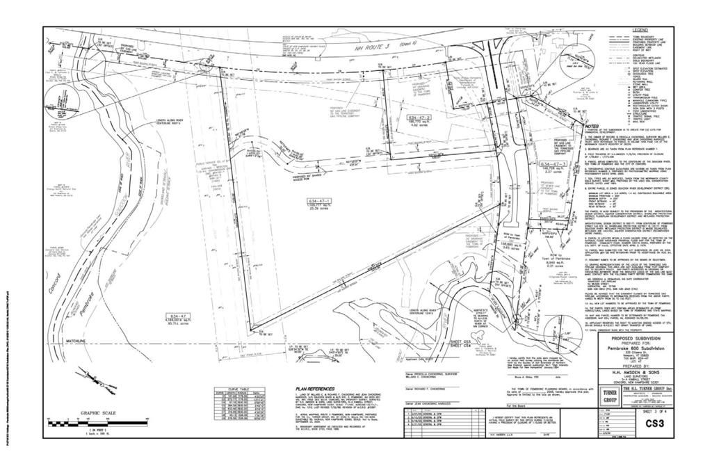
1 Pembroke Street Pembroke, NH /- Acres Hard to find large development parcel at lighted intersection of Route 3 and Route 106 in Pembroke NH. From 3 to /- acres available. Flexible zoning could allow for many types and/or uses. Perfect for retail, office, industrial, corporate complex, or possible affordable housing. $ 345,000 to $1,950,000 Close to Interstate 93 Lighted Intersection Public Water/Sewer & Natural Gas Flexible Zoning Uses Much Engineering Done Multiple Sizes & Pricing Options Scott Reiff Direct: Scott.Reiff@Verani.com Corporate Office: Additional Info:
2 General Information *Property address: Pembroke Street, Pembroke, NH (for GPS & mapping systems use 599 Pembroke Street, Pembroke NH 03275) * Property Type: Land (Commercial/Industrial) Access and Directions to property: Take the US-3 South exit (#13) off of I-93. At end of ramp turn right onto US-3/Manchester Street/Korea Veterans Memorial Bridge. Continue to follow US-3 for 2.3 miles. The property is on the right. Full description of Lot or Property: Hard to find large development parcel at lighted intersection of Route 3 and Route 106 in Pembroke NH. From 3 acres to /- acres available. Parcel(s) are located at lighted intersection and already have much engineering. Zoning could allow for many various types of activities and/or uses. Perfect for retail, office or corporate complex. There has been discussions about multifamily and/or affordable housing for the area, too. 3-5 acres available intersection of new Kline Way as well as other lot sizes that are able to be designed. Demographics excellent for medical facility, distribution, service, etc. Public water/sewer and natural gas. For additional info go to Lot #:Map 634, Lot 47 Price: $1,950,000 for entire lot. Now offering lot(s) from 3-5+ acres for $115,000 per acre. Site Data * Lot Size: acres * Frontage: Primary Road: Approx. 2, Secondary Road: * Sewage: Municiple Gas: Propane Natural * Water: Well Municipal * Zoning: Multiple zones: Commercial / light industry (C-I), Limited Office - (LO), with majority being Suncook river Development (SRD) Permitted Uses: * Traffic count report: closest number: 15,000 where: Route 3 just South of Beacon Hill Road Additional Information * Taxes: $5,699 per year. For year:2016 *Property is in current use. * Deed: Book: 3153 Page: 1099 Date: Not available: Area: o Other businesses: Dunkin Donuts, Meat House, Associated Grocers o Transportation:located on intersection of Route 3 and Route 106, close to I-93 o Local improvements: o Other area notables: deemed reliable, but we make no representation or warranties, expressed or implied, as to accuracy of the information.

3
4
5


6
7

8

9
10
11
12
13

14
15
16 Property Location: PEMBROKE ST MAP ID: 634/ / 47/ / Bldg Name: State Use: 6000 Vision ID: 2353 Account # Bldg #: 1 of 1 Sec #: 1 of 1 Card 1 of 1 Print Date: 06/14/ :25 el Description CURRENT OWNER TOPO. UTILITIES STRT./ROAD LOCATION CURRENT ASSESSMENT P P G DEVELOPMENT, LLC 4 Rolling 2 Public Water 1 Paved 3 Rural Description Code Appraised Value Assessed Value ATTN: GORDON WELCH 3 Public Sewer FARM ,800 10, HIGHVIEW CIRCLE FOREST ,000 6,030 PEMBROKE, NH FOREST ,600 2,860 UNPROD , MANCHESTER, NH Additional Owners: Other ID: TIF Taxpayer Req Flood Plain Admin Review For Sale GIS ID: RECORD OF OWNERSHIP P P G DEVELOPMENT, LLC P P G DEVELOPMENT, LLC P P G DEVELOPMENT, LLC P P G DEVELOPMENT, LLC P P G DEVELOPMENT, LLC PEMBROKE 600 CORP SUPPLEMENTAL DATA Abatement D.O.B. VISION $2,950,000 2/17: MLS#43 ASSOC PID# Total 677,200 19,489 BK-VOL/PAGE SALE DATE q/u v/i SALE PRICE V.C. PREVIOUS ASSESSMENTS (HISTORY) 3572/ /06/2017 U V 35 Yr. Code Assessed Value Yr. Code Assessed Value Yr. Code Assessed Value 3551/ /11/2017 U V , , , / /27/2016 U V , , , / /04/2009 U V 1N , , , / /05/2009 U V 600,700 1L / /12/2008 U V 1N Total: 19,489 Total: 19,654 Total: 19,654 EXEMPTIONS OTHER ASSESSMENTS This signature acknowledges a visit by a Data Collector or Assessor Year Type Description Amount Code Description Number Amount Comm. Int. NBHD/ SUB E/A *ACCESS **INFLUENCE OF PROPERTY LINE 5/7/ /288 ACCESS DEED 5/12/ /1761 CONTROL OF ACCESS DEED 9/4/ /1099 ACCESS DEED 5/28/13 QUARTERLY COMP, NO CHANGE - RR 4/15/16 NO CHANGE - CB YES Total: ASSESSING NEIGHBORHOOD NBHD Name Street Index Name Tracing Batch NOTES 2/17: FS ASKING $2,950,000 OR $1,900,000 IF SUBDIVIDED 4/17: LLA FOR ROADWAY REMOVED 2.95 AC FROM HRDW CAT; LOT NOW AC:MH Appraised Bldg. Value (Card) Appraised XF (B) Value (Bldg) Appraised OB (L) Value (Bldg) Appraised Land Value (Bldg) Special Land Value Total Appraised Parcel Value Valuation Method: APPRAISED VALUE SUMMARY Net Total Appraised Parcel Value 677,200 BUILDING PERMIT RECORD VISIT/ CHANGE HISTORY Permit ID Issue Date Type Description Amount Insp. Date % Comp. Date Comp. Comments Date Type IS ID Cd. Purpose/Result 04/04/ /15/ /11/ /28/ /19/2009 MH CB MH RR TH CU-Land Review/Change Quarterly - Ext view only CU-Land Review/Change Vac Land Field Reveiw-Reval , ,200 Adjustment: 0 C B # Use Code Use Description FARM FARM WP U HW U UNPRO Zone D Front Depth C-1A C-1A C-1A C-1A C-1A Units AC AC AC AC AC LAND LINE VALUATION SECTION Unit I. Acre C. ST. Special Pricing Price Factor S.A. Disc Factor Idx Adj. Notes- Adj Spec Use Spec Calc 75, SOU 1.00 CU , CF=PSNH EASEMENT/TOPOCU , WET CU , CU4 55 7, CU3 18 S Adj Fact Adj. Unit Price , , , , , Land Value 75, , ,000 93,600 22,800 Total Card Land Units: AC Parcel Total Land Area: AC Total Land Value: 677,200
17 Ttl. Gross Liv/Lease Area: Property Location: PEMBROKE ST MAP ID: 634/ / 47/ / Bldg Name: State Use: 6000 Vision ID: 2353 Account # Bldg #: 1 of 1 Sec #: 1 of 1 Card 1 of 1 Print Date: 06/14/ :25 el Description CONSTRUCTION DETAIL CONSTRUCTION DETAIL (CONTINUED) Element Cd. Ch. Description Element Cd. Ch. Description Model 00 Vacant Code 6000 MIXED USE Description FARM Percentage 100 Code COST/MARKET VALUATION Adj. Base Rate: Net Other Adj: 0.00 Replace Cost 0 AYB EYB 0 Dep Code Remodel Rating Year Remodeled Dep % Functional Obslnc External Obslnc Cost Trend Factor 1 Condition % Complete Overall % Cond Apprais Val Dep % Ovr 0 Dep Ovr Comment Misc Imp Ovr 0 Misc Imp Ovr Comment Cost to Cure Ovr 0 Cost to Cure Ovr Comment OB-OUTBUILDING & YARD ITEMS(L) / XF-BUILDING EXTRA FEATURES(B) Description Sub Sub Descript L/B Units Unit Price Yr Gde Dp Rt Cnd %Cnd Apr Value No Photo On Record Code BUILDING SUB-AREA SUMMARY SECTION Description Living Area Gross Area Eff. Area Unit Cost Undeprec. Value

18
19
20
21
22
23 INFORMATIONAL LINKS AVAILABLE FOR PROPERTY/AREA Pembroke, NH Tax Map: nh.com/plan.asp Zoning Map: nh.com/contact.asp Zoning Definitions: nh.com/documents/towncodechapter143.pdf Demographic Profile: Traffic Reports:
Town of Raymond, Maine Notice of Public Sale of Tax Acquired Property
 Town Raymond, Maine Notice Public Sale Tax Acquired Property OFFICIAL NOTICE Please take notice that the Town Raymond will conduct a public sale the following properties in Raymond, subject to the following
Bldg #: 1 of 1 Sec #: 1 of 1 Card 1 of 1 Print Date: 11/06/ :31 ld i ti UTILITIES STRT./ROAD LOCATION CURRENT ASSESSMENT HANOVER, TOWN OF
 Property Location: GREENSBORO RD MAP ID: 5/ 8/ / / Bldg Name: State Use: 93R Vision ID: 779 Account # Bldg #: of Sec #: of Card of Print Date: /6/4 7:3 CURRENT OWNER TOPO. ld i ti UTILITIES STRT./ROAD
Bldg Name: State Use: 1090 Vision ID: 2422 Account # 07Average RES LAND 109,100 DUXBURY, MA Total 1,522,000 1,522,000 RECORD OF OWNERSHIP
 Bldg #: Card Print Date: //8 : CURRENT OWNER el TOPO. Description -- UTILITIES STRT./ROAD LOCATION CURRENT ASSESSMENT Water Arterial Description Code Appraised Value Assessed Value 8No Sewer Paved,88,4,88,4
Description Code Appraised Value Assessed Value THE 108 MATTAPOISETT NK ROAD N. Res Dwell. Res Land
 Bldg #: 3 Card 3 Print Date: /29/27 2:35 CURRENT OWNER TOPO. UTILITIES STRT./ROAD LOCATION CURRENT ASSESSMENT FIELD HORACE F III & KAREN J TRUS Appraised Value Assessed Value THE 8 MATTAPOISETT NK ROAD
RES LAND 172,500 RAYNHAM, MA , 101. Total 7,331,300 7,331,300 BK-VOL/PAGE SALE DATE q/u v/i SALE PRICE V.C. PREVIOUS ASSESSMENTS (HISTORY)
") Property Location: CONNO AVE MAP ID:3/ 99/ / / State :2C Vision ID: 22 Account # 399 Bldg #: of 4 Sec #: of Card of 4 Print Date:/24/2 7: CURRENT OWNER TOPO. UTILITIES STRT./ROAD LOCATION CURRENT ASSESSMENT
Property Location: CONNO AVE MAP ID:3/ 99/ / / State :2C Vision ID: 22 Account # 399 Bldg #: of 4 Sec #: of Card of 4 Print Date:/24/2 7: CURRENT OWNER TOPO. UTILITIES STRT./ROAD LOCATION CURRENT ASSESSMENT
Bldg Name: State Use: 101 Vision ID: 2381 Account # 5 Private Well 1 Paved Description Code Appraised Value Assessed Value Res Land.
 Property Location: QUINN RD MAP ID: / 32/ A/ / Bldg Name: State : Vision ID: 238 Account # Bldg #: Card Print Date: 6/2/28 3: cel 62 Sec #: CURRENT OWNER TOPO. UTILITIES STRT./ROAD LOCATION CURRENT ASSESSMENT
COMMERC. COMMERC. 648,100 LIVERPOOL, NY COM LAND. 561,100 Additional Owners: Other ID: COMMERC.
 Property Location: 46 ELM ST MAP ID: 2/ 65/ 75A/ / State : Vision ID: 9883 Account # Bldg #: 3 Card 3 Print Date: /3/27 :48 cel 2-65-75- Sec #: CURRENT OWNER TOPO. UTILITIES STRT./ROAD LOCATION CURRENT
Bldg Name: State Use: 1090 Vision ID: 1790 Account #
 Bldg #: of 3 Sec #: of Card of 3 Print Date: /27/28 3:25 CURRENT OWNER TOPO. UTILITIES STRT./ROAD LOCATION CURRENT ASSESSMENT Appraised Value Assessed Value 269,4 269,4 36 85 CYPRESS ST RES LAND TISBURY,
50 Route 111 ( 5 Ledge Road), Windham, NH
, Windham, NH") 5 Route 111 ( 5 Ledge Road), Windham, NH ~For Lease~ Berkshire Hathaway Verani Commercial Office/Retail/Industrial Space Highly visible location with road frontage on both Route 111 and Ledge Road. Easy
5 Route 111 ( 5 Ledge Road), Windham, NH ~For Lease~ Berkshire Hathaway Verani Commercial Office/Retail/Industrial Space Highly visible location with road frontage on both Route 111 and Ledge Road. Easy
COM LAND 62,600 MANSFIELD, MA ,700 Additional Owners: Other ID:
 Vision ID: 836 Account # 836 Bldg #: of 3 Sec #: of Card of 4 Print Date:/6/29 22:36 CURRENT OWNER TOPO. UTILITIES STRT./ROAD LOCATION CURRENT ASSESSMENT 4 Rolling 2 Public Water Paved Appraised Value
Bldg Name: State Use: 1090 Vision ID: 39 Account #
 Bldg #: 1 of 3 Sec #: 1 of 1 Card 1 of 3 Print Date: 11/27/218 8:48 CURRENT OWNER TOPO. UTILITIES STRT./ROAD LOCATION CURRENT ASSESSMENT Appraised Value Assessed Value CONWAY ERIN R 1,681,8 1,681,8 6 6
TOWN OF SKOWHEGAN, MAINE NOTICE OF FORECLOSURE SALE
 TOWN OF SKOWHEGAN, MAINE NOTICE OF FORECLOSURE SALE The Board of Selectmen of the Town of Skowhegan is accepting bids for the purchase of the municipality s interest in three (3) tax-acquired properties.
VISION DV Map # GIS ID:
 Property Location: 36 BERLIN ROAD MAP ID: / / 7B/ / Bldg Name: State : Bldg #: 4 Card 4 Print Date: 9/6/6 :57 el 94 Sec #: CURRENT OWNER TOPO. UTILITIES STRT./ROAD LOCATION CURRENT ASSESSMENT Public Water
VISION Historic Dis GIS ID: 22-33
 Property Location: 6 SOUTH ST MAP ID: 22/ / 33/ / ldg Name: State : ldg #: of 4 Sec #: of Card of 4 Print Date: /26/22 23:44 CURRENT OWNER TOPO. UTILITIES STRT./ROAD LOCATION CURRENT ASSESSMENT ERERIAN
COM LAND 44,200 MANSFIELD, MA BK-VOL/PAGE SALE DATE q/u v/i SALE PRICE V.C. PREVIOUS ASSESSMENTS (HISTORY) 75/ 33
 75/ 33") Property ocation: 3 WINTHROP AVE MAP ID:2/ 9/ / / State :3 Vision ID: 78 Account # 78 Bldg #: of 3 Sec #: of Card of 3 Print Date:/27/27 4:2 CURRENT OWNER TOPO. UTIITIES STRT./ROAD OCATION CURRENT ASSESSMENT
Property ocation: 3 WINTHROP AVE MAP ID:2/ 9/ / / State :3 Vision ID: 78 Account # 78 Bldg #: of 3 Sec #: of Card of 3 Print Date:/27/27 4:2 CURRENT OWNER TOPO. UTIITIES STRT./ROAD OCATION CURRENT ASSESSMENT
Bldg Name: State Use: 108 Vision ID: 1950 UTILITIES STRT./ROAD LOCATION CURRENT ASSESSMENT RES EXCES. 259,960 CROMWELL, CT Additional Owners:
 Property Location: 6&8 PINEY RIDGE ROAD MAP ID: 3/ 47/ 3-/ / Bldg Name: State : 8 Vision ID: 9 Account # Bldg #: of 3 Sec #: of Card of 3 Print Date: /4/ 4: CURRENT OWNER el TOPO. UTILITIES STRT./ROAD
PROPERTY INFORMATION PACKAGE #
 PROPERTY INFORMATION PACKAGE #14-165 Mortgagee s Foreclosure AUCTION 1,658+/-SF, 3BR, 2BA SINGLE FAMILY HOME Close to Main Routes, Center of Town & Public Transportation 49 COTTAGE ST., MANSFIELD, MA Tuesday,
Bldg Name: State Use: 3840 Vision ID: 1043 Account #
 Bldg #: of 6 Sec #: of ard of 6 Print Date: /27/28 9:6 URRENT OWNER TOPO. UTILITIES STRT./ROAD LOATION URRENT ASSESSMENT ode Appraised Value Assessed Value 926,2 926,2 36 25 S. BAYSHORE DR SUITE 28 OM
The LAUNDRY CENTER OF CAPE COD. For Sale! that incorporates ultra violet light cleansing. EQUIPMENT, EMPLOYEES & OPPORTUNITY
 CAREY COMMERCIAL, INC. BUSINESS & INVESTMENT PROPERTY 46 MAIN STREET HYANNIS, MA 26 Contact: Cecelia Carey 58-79-89 Ext. 5 cecelia@careycommercial.com The LAUNDRY CENTER OF CAPE COD For Sale! 897 Route
Bldg Name: State Use: 101 Vision ID: Account # Sec #: 1 of 1 UTILITIES STRT./ROAD LOCATION CURRENT ASSESSMENT 4 Heavy 2 Typical
 Property Location: 485 MOUNTIN ROD MP ID: D6/ 37/ 485/ / ldg Name: State : Vision ID: 2759 ccount # ldg #: 2 Card 3 Print Date: 4/2/26 :45 CURRENT OWNER el TOPO. Description 37 485 Sec #: UTILITIES STRT./ROD
UNDERSTANDING YOUR PROPERTY RECORD CARD
 UNDERSTANDING YOUR PROPERTY RECORD CARD OBJECTIVE: At first glance, the real estate property assessment record card can be intimidating. There is a wealth of information that can be difficult to read and
264 North Broadway, Unit 106, Salem, NH
 264 North Broadway, Unit 106, Salem, NH ~For Sale ~ Berkshire Hathaway Verani Commercial Division is pleased to announce the availability of Unit 106 located in the Breckenridge Plaza. This 1,466+/- SF
2 Range Road, Salem, NH 03079
 2 Range Road, Salem, NH 03079 Berkshire Hathaway Verani Commercial Division is pleased to announce the availability of high profile commercial/retail space at 2 Range Road in Salem, NH. This property is
50 Route 111 ( 5 Ledge Road), Windham, NH
, Windham, NH") 50 Route 111 ( 5 Ledge Road), Windham, NH ~For Lease~ Prudential Verani Commercial Services is pleased to announce Office/Retail/Industrial Space Highly visible location with road frontage on both Route
50 Route 111 ( 5 Ledge Road), Windham, NH ~For Lease~ Prudential Verani Commercial Services is pleased to announce Office/Retail/Industrial Space Highly visible location with road frontage on both Route
NEW LONDON, NEW HAMPSHIRE 375 MAIN STREET NEW LONDON, NH
 TOWN OF NEW LONDON, NEW HAMPSHIRE 375 MAIN STREET NEW LONDON, NH 03257 WWW.NL-NH.COM READING YOUR PROPERTY RECORD CARD Vision Appraisal Technology 1.) Property Location: The actual physical location of
26 Ermer Road ~ 2nd Floor~ Salem, NH 03097
 26 Ermer Road ~ 2nd Floor~ Salem, NH 03097 Berkshire Hathaway Verani is pleased to announce the availability of an open concept retail/office suite located on the second floor at 26 Ermer Road in Salem,
Commercial Development Land Londonderry, NH
 Commercial Development Land Londonderry, NH Exit 5 retail, high exposure land. 1.081 acres +/- located at lighted intersection at Rt 28 & new Vista Ridge Rd. Vista Ridge is a new large residential complex
1B Commons Drive ~ Unit 9B~ Londonderry, NH
 1B Commons Drive ~ Unit 9B~ Londonderry, NH Berkshire Hathaway Verani Commercial Services is pleased to announce the availability of ~For Sale~ 978+/- SF office / retail space Multiple private offices
Highly Visible Commercial Land
 Highly Visible Commercial Land W. US Hwy 90 @ Real Terrace, Lake City, FL Presented by: Charlie Sparks BROKER 386-755-0808 charlie@charliesparks.com Sale Price: $1,899,000 Zoning: Commercial Intensive
Commercial Lot For Sale
 Commercial Lot For Sale US Hwy 129 @ I-10, Live Oak, FL Presented by: Charlie Sparks BROKER 386-755-0808 charlie@charliesparks.com Price: $550,000 Lot Size: 5.89 Acres Zoning: Commercial Highway FOR MORE
DECEMBER 22, 2015 AT 5:30 PM WORK SESSION AGENDA
 MONROE COUNTY COUNCIL Monroe County Courthouse Room 306 100 W Kirkwood Avenue Bloomington, IN 47404 Phone: (812) 349-7312 Fax: (812) 349-2982 Cheryl Munson, President Shelli Yoder, Vice President Ryan
AREIS Online Report TOLEDO CITY - TOLEDO CSD EVANS PAUL B & ELIZABETH A C / ,700 74, W SYLVANIA AVE TOLEDO, OH ,500
 AREIS Online Report Parcel: Assessor: 1886007 03900003 Taxing District: TOLEDO CITY - TOLEDO CSD Frontage: 45 Depth: 129 Owner: EVANS PAUL B & ELIZABETH A Class/Landuse: Values(100%): C / 429 Acres: TLA:
Professional Office Building
 Professional Office Building 197 SW Waterford Court, Lake City, FL Presented by: Charlie Sparks BROKER 386-755-0808 charlie@charliesparks.com Sale Price: $579,000 Zoning: Commercial Land Size: 3.04 Acres
Residential Development Tract For Sale! Potential for Multi-Family Housing
 Residential Development Tract For Sale! Potential for Multi-Family Housing E Baya Avenue, Lake City, FL Presented by: Charlie Sparks BROKER 386-755-0808 charlie@charliesparks.com Sale Price: $325,000 Total
$950/mo Modified Gross
 1B Commons Drive ~ Unit 13A~ Londonderry, NH, For Lease Berkshire Hathaway Verani Commercial Division is pleased to announce the availability of Unit 13A at 1B Commons Drive, Londonderry, New Hampshire.
15 Tanguay Avenue, Nashua, NH
 15 Tanguay Avenue, Nashua, NH Berkshire Hathaway Verani Realty Commercial Division is pleased to announce the availability of executive office suites, with individual mailing addresses, at 15 Tanguay Ave.
Commercial Land For Sale 1081 & 1083 Campbell Avenue West Haven, Connecticut
 Commercial Land For Sale 1081 & 1083 Campbell Avenue West Haven, Connecticut Available:.50 acres DEMOGRAPHICS Radius Population Avg. Household Median Age Income 1 mile 20,433 $58,170 30.5 3 miles 124,773
FOR SALE THE FOLLOWING PROPERTY IS BEING OFFERED FOR SALE BY THE STATE OF NORTH CAROLINA BRISTOL DRIVE, STATESVILLE, NC SPO FILE #049-WF
 FOR SALE THE FOLLOWING PROPERTY IS BEING OFFERED FOR SALE BY THE STATE OF NORTH CAROLINA BRISTOL DRIVE, STATESVILLE, NC SPO FILE #049-WF Open for bids beginning April 24 ending on May 8, 2017. LOCATION:
HENDERSON STEVE A 1220 DR MLK JR BLVD 430, Restaurant, Cafeteria or Bar PENDLETON AVE CORRID 1/2
 8----.-3 HENDERSON STEVE A 22 DR MLK JR BLVD 3, taurant, Cafeteria or Bar PENDLETON AVE CORRID 2 Parcel Number 8----.-3 Local Parcel Number 8-2-2 Tax ID: 8-2-2 Routing Number K-P Property Class 3 taurant,
Great Hwy Frontage in Growing Area 3752 W US Hwy 90, Lake City, FL
 Great Hwy Frontage in Growing Area 3752 W US Hwy 90, Lake City, FL Presented by: Charlie Sparks BROKER 386-755-0808 charlie@charliesparks.com Sale Price: $595,000 Zoning: CHI Frontage: 225 ft. on Hwy 90
Development Site For Sale SW SR 47, Lake City, FL
 Development Site For Sale SW SR 47, Lake City, FL Presented by: Scott Stewart 386-867-3498 scott@sdstewart.com Sale Price: $2,500,000 Zoning: Commercial Intensive Building Size: 2,353 SF Lot Size: 13.14
KINGSTON ASSESSING OFFICE
 Map: R3 Lot: 18 Sub: Card: 1 of 3 5 ROADSTONE RD KINGSTON OWNER INFORMATION SALES HISTORY Date Book Page Type Price Grantor PO BOX 89 Printed: 4/22/214 PLAISTOW, NH 3865-89 2/17/14 KCPU 3/4/13 KCPU 11/13/9
Multi-Family. Expire Date List Type Excl Right to Sell VAR/DUAL COMM Y/N. Limited Service Y/N. Bonus Y/N No County. Area. Zoning Flood Plain Y/N No
 Multi-Family Co-list Agent Name Co-list Agent 2 Name List Price List Expire List Type Excl Right to Sell VAR/DUAL COMM Y/N No Limited Service Y/N Entry Only Y/N No BA Comm % Bonus Y/N No County No Area
KINGSTON ASSESSING OFFICE
 Map: 0000U4 Lot: 000218 Sub: 000000 Card: 1 of 1 4 TWELFTH ST KINGSTON OWNER INFORMATION SALES HISTORY BENNET, HARRY Date Book Page Type Price Grantor 08/19/2009 5043 2950 U I 51 67,000 FEDERAL HOME LOAN
AUTO SALVAGE YARD AND SCRAP METAL BUSINESS WITH REAL ESTATE
 AUTO SALVAGE YARD AND SCRAP METAL BUSINESS WITH REAL ESTATE Auto Salvage and recycling business and real estate for sale. 40 yr old business available turn key or real estate & business only (with all
$ 325, Dunster Ave, Greenville, NH Scott Reiff VERANI x 2199
 8 Dunster Ave, Greenville, NH 03048 ~FOR SALE ~ Berkshire Hathaway Verani Commercial Division is please to announce the availability of 8 Dunster Ave. in Greenville, NH. If you are looking for a unique
16 Manning Street ~Unit 108~ Derry, NH 03038
 16 Manning Street ~Unit 108~ Derry, NH 03038 Berkshire Hathaway Verani Commercial Services is pleased to announce the availability of Unit 108 at the Granary on Manning Street in Derry, NH. This 912 +/-
PEABODY COMMERCIAL PROPERTY RECORD CARD. Situs : 18 CROWNINSHIELD ST Map ID: A Class: Apartments - More than Eight Un
 7 Situs : 8 CROWNINSHIELD ST Map ID: 74-65A Class: s - More than Eight Un CURRENT OWNER CROWNINSHIELD APARTMENT ASSOC % STUART COMINS MANAGER 8 CROWNINSHIELD ST MA 96 Property Notes GENERAL INFORMATION
55 Bridge Street, Manchester, NH 03101
 55 Bridge Street, Manchester, NH 03101 ~ FOR SALE OR LEASE~ Berkshire Hathaway Commercial Division is pleased to announce the availability of an updated and upscale building now for sale/lease at 55 Bridge
Commercial Property for Sale 118 Plains Road Milford, Connecticut
 Commercial Property for Sale 118 Plains Road Milford, Connecticut Available: Former Mobil Gas Station & Convenience Store DEMOGRAPHICS Radius Population Avg. Household Median Age Income 1 mile 7,590 $114,144
Restaurant For Sale or Lease 1319 Cedar Dr La Marque, TX Sale - $200,000 $1876 / Month Gross. Cell: Dwayne Morris.
 Restaurant For Sale or Lease 1319 Cedar Dr La Marque, TX 77568 Jj Sale - $200,000 $1876 / Month Gross LOCATION 1319 Cedar Drive, La Marque, TX SE Corner of Cedar Dr. and Foreman St. Between I-45 and Hwy
Land/Lot For Sale Data Input
 * = Required Field Land/Lot For Sale Data Input Listing Contract Information General Property Info Adult 55 Gated Horse Property Seasonal On leased Land *Sub Property Type *Property ID No: *Listing *Expiration
Prime Restaurant/Retail Space 344 Washington Avenue North Haven, Connecticut
 Prime Restaurant/Retail Space 344 Washington Avenue North Haven, Connecticut Available: 4,200 SF DEMOGRAPHICS Radius 1 mile 3 miles 5 miles Population 3,735 34,538 98,346 Avg. Household Income $84,373
21 AC LESTINA COMMERCIAL SITE AT BRAIDWOOD
 21 AC LESTINA COMMERCIAL SITE AT BRAIDWOOD For more information contact: 815-741-2226 mgoodwin@bigfarms.com County: Will Township: Reed-Custer Township Gross Land Area: 21.7 Acres Property Type: Vacant
Parcel #90 Development Sites Haigis Parkway at I-95 (Maine Turnpike) Exit 42. Scarborough, Maine SOLD. 2.8 acres. 3 acres 2.
 Exit 42. Scarborough, Maine SOLD. 2.8 acres. 3 acres 2.") Parcel #90 Development Sites Haigis Parkway at I-95 (Maine Turnpike) Exit 42 Scarborough, Maine Route 1 SOLD 2.8 acres 6.5 3 acres 2.6 to 29 acres I-95 8.8acres Building Sites Available from $219,000 to
Parcel #90 Development Sites Haigis Parkway at I-95 (Maine Turnpike) Exit 42 Scarborough, Maine Route 1 SOLD 2.8 acres 6.5 3 acres 2.6 to 29 acres I-95 8.8acres Building Sites Available from $219,000 to
COMMERCIAL OPPORTUNITY. Schmitt Real Estate Co Overseas Highway, Tavernier, FL. Brian c. schmitt. Features: Year Built:
 COMMERCIAL OPPORTUNITY 91731 Overseas Highway, Tavernier, FL Features: Location: Space: Year Built: Taxes: Price: MLS#: Schmitt Real Estate Co. Commercial property for sale with 150' on US1 and 95' on
5.816 Acres On I-45 For Sale La Marque, TX 77568
 5.816 Acres On I-45 For Sale La Marque, TX 77568 Price Reduced To: $2.50/SF = $633,362 Features 5.816 Acres ( Dividable ), 344 FT Frontage On I-45 315 Ft Frontage on FM 519 Two Plats 1.11 Acres & 4.706
38 AC MILLSDALE RD. SW Corner of Millsdale Road & Bridge Rd Elwood IL. For more information contact: Mark Goodwin
 38 AC MILLSDALE RD For more information contact: 1-815-741-2226 mgoodwin@bigfarms.com Goodwin & Associates Real Estate, LLC is an AGENT of the SELLERS. County: Will Township: Jackson Gross Land Area: 38.5
Retail Or Industrial Land For Sale
 Retail Or Industrial Land For Sale 345 /2 Newfield St. (Rt 3), Middletown, Ct 8.3 Acres (Includes Brick Ranch & Barns) & Tuttle Rd 2 Parcels With Double Access On Newfield St. (5.6 Acres)& Tuttle Rd. (2.65
Land. Effective Frontage. Effective Depth. Factor Base Rate Adjusted Rate Estimated Value Influence Factor Land Value. Acreage / Sq. Ft.
 Parcel Number 91539 County Marion, IN Township WAYNE Corporation District Plat Map Alt Parcel 49-5-36-17-6.-982 Property Class 463 Tax District 982 Neighborhood 9175671-9-175c-1 Ownership Name WESTWOOD
Bethel Woods. Commercial Land 20.72± Acres. For more information: Anthony Maronitis
 For Sale, Lease or Build to Suit Commercial Land 20.72± Acres Bethel Woods 1337 W 5th St, Marysville, Ohio 43040 Property Features 20.72± acre development Can be subdivided Zoned Traffic Oriented Commercial
High Point Retail Opportunity
 2012 N Main St High Point, NC 27262 PROPERTY HIGHLIGHTS 1.8 Acre Desirable Retail Site Existing 11,908+/- RSF Retail Space- Former Rite Aid Outstanding Location! High Traffic Counts Phone: Fax: 336-886-4269
C A M A...C A R D...(Hardwick Township.../...Warren County)
") C A M A...C A R D...(Hardwick Township.../...Warren County) *** Links:... Map Page Map Book Google Map Vital Geo GIS Map Deed Last Scanned http://www.munwebstor.us/maps219/page3.pdf http://www.municipalassessornj.com/publisher/mapbook/219/mapbook/index.html
C A M A...C A R D...(Hardwick Township.../...Warren County) *** Links:... Map Page Map Book Google Map Vital Geo GIS Map Deed Last Scanned http://www.munwebstor.us/maps219/page3.pdf http://www.municipalassessornj.com/publisher/mapbook/219/mapbook/index.html
W James Street Lancaster, PA 17603
 300-308 W James Street Lancaster, PA 17603 For Sale $1,395,000 Apartment Building Restaurant & Equipment Liquor License Building Information Building Size: 9,700 +/- SF Total 4,700 +/- SF Restaurant Exterior:
 Page 1 of 2 Summary Parcel ID 884730152002 Alternate ID 580830 Property Address 5600 Harbor Dr Sioux City Sec/Twp/Rng 30-88-47 Brief Legal Description LL-SC COMM 88-47 A TCT N & W OF C & N W RR CONTAINING
Portofino Plaza Lease Space
 FOR LEASE $14.00/psf Property Details LEASE RATE LEASE SPACE(S) LEASE TERMS BUILDING SIZE BUILDING TYPE ACREAGE $14.00/psf 7,333 sf 3-5 years 34,000 SF Neighborhood Center 4.00 AC The Portofino Plaza is
Strip Center For Lease 3360 Shaver, Pasadena, TX
 Strip Center For Lease 3360 Shaver, Pasadena, TX Lease: $1.25 - $1.50/SF Features 20,146 SF Total Space 1000 SF Minimum Space Remodeled in 2011 Signing Leases Now Space Delivered in Vanilla Box Condition
Lancaster Ave Center 801 Lancaster Ave, Reading PA 19607
 up to 45,112 SF Retail/Service Bay Space Lancaster Ave Center, Reading PA 19607 Property Features Modern automotive showroom, shop and office area for automotive sales, repair and servicing Spacious parking
Property Summary. Location Overview. Property Summary. Property Overview. Georgesville Road Investment Portfolio
 For Sale Investment Portfolio 63,633 SF Georgesville Road Investment 435, 487, 491 Georgesville Road, Columbus, Ohio 43228 Property Features Two Retail Properties and one self storage business Situated
THE MAJOR FORTUNES IN AMERICA HAVE BEEN MADE IN LAND. ~JOHN D. ROCKEFELLER ACRES ROCHESTER ROAD ROAD TWIN BRIDGES, MT 59754
 THE MAJOR FORTUNES IN AMERICA HAVE BEEN MADE IN LAND. ~JOHN D. ROCKEFELLER 90.13 ACRES ROCHESTER ROAD ROAD TWIN BRIDGES, MT 59754 OFFERED AT: $199,000 Big spaces, clean air & big scenery, Montanas fresh
TOWN OF ELIOT PLANNING BOARD SUBDIVISION APPLICATION
 TOWN OF ELIOT PLANNING BOARD SUBDIVISION APPLICATION This application shall conform in all respects to the Land Subdivision Standards of Chapter 41 of the Planning Board of the Town of Eliot code of ordinances.
1 of 6 6/11/ :05 AM
 of 6 6//20 0:0 AM Summary Sale & Lease Info Currently Active For Sale () Stats & Trends This Property Nearby Properties City Index Asking Price $/SF $3.7 $62.6 $2.34 Property Details Primary Property Type:
OAKBROOK SUBDIVISION! 48.7 ACRES! JEFFERSON ST., BROOKSVILLE, FL
 General Map OAKBROOK SUBDIVISION! 48.7 ACRES! JEFFERSON ST., BROOKSVILLE, FL! General Map Asking Price: $99,! Size: 48.7 acres! Zoning: C/PDP for 15 SF lots (41 x11 ) & 66, sf of retail commercial.! Utilities:
Property Information. Date: 4/12/2016. Parcel ID: R Site Address: 81 N Olde Park Pl Eagle Warmest Regards,
 Property Information Date: 4/12/2016 Parcel ID: R4549500180 Site Address: 81 N Olde Park Pl Eagle 83616 Warmest Regards, The TitleOne Team TitleOne Corporation www.titleonecorp.com Notice: This report
****NOT FOR PUBLIC DISTRIBUTION: MEMBERS ONLY**** Vacant Land 241 Sparkling Water Cir List: $1,199, Active Sunrise Beach, MO 65079
 Listing ****NOT FOR PUBLIC DISTRIBUTION: MEMBERS ONLY**** Vacant Land 241 Sparkling Water Cir List: $1,199,900 3505215 Active Sunrise Beach, MO 65079 County: Camden Area: I MM Area: Osage Bus Name: MM
FOR SALE $2,249,000 DAVIE MEDICAL OFFICE BUILDING 7705 DAVIE ROAD EXT. DAVIE, FL 33024
 FOR SALE $2,249,000 DAVIE MEDICAL OFFICE BUILDING 7705 DAVIE ROAD EXT. DAVIE, FL 33024 11,979 Sq. Ft. Building Lot size 0.70 AC Zoning: B-2 Built in 1975 Property Type: Medical Office Six Apartments Units
Commercial Investment Property
 Commercial Investment Property Children Are Special Daycareschool 700 E. Sharon Ave Moses Lake $1,500,000 Children Are Special Daycareschool is established and very successful. They are licensed for 87
Features. High-traffic, Commercial location! $1,250,000 N. US-31 SOUTH MARK HAGAN
 N. US-31 SOUTH TRAVERSE CITY, MI 49684 OFFERED AT: High-traffic, Commercial location! $1,250,000 Features Prime Commercial location with 450 of US-31 road frontage Located next to TC RV, & has municipal
FOR SALE STATE RD. 70 AND S JENKINS RD, FT PIERCE, FL 34947
 FOR SALE STATE RD. 70 AND S JENKINS RD, FT PIERCE, FL 34947 4.5 AC Development Site Sabal Chase ORANGE BLOSSOM MALL Portofino Landings Treasure Cay LAND: LAND USE: ZONING: UTILITIES: PRICE: 4.5 +/- Acres
Bexar CAD. Property Search Results > FIRST X REALTY LP for Year Property. Values. Taxing Jurisdiction. Account. Location.
 Bexar CAD Property Search Results > 515399 FIRST X REALTY LP for Year 2015 Property Account Property ID: 515399 Legal Description: NCB 12912 BLK 4 LOT E 100 FT OF 9 Geographic ID: 12912 004 0090 Agent
PROPERTY INFORMATION PACKAGE #
 PROPERTY INFORMATION PACKAGE #13-1436 Mortgagee s Foreclosure AUCTION 23,323+/-SF, 2-STORY RETAIL/OFFICE BUILDING ON 2.32+/-AC. Map 200, Lot 21 - Zoning: Business District A New Construction - Residential
TURN KEY BUSINESS WITH REAL ESTATE
 TURN KEY BUSINESS WITH REAL ESTATE AUTO BODY REPAIRS AND SALES NEWPORT NH Profitable 38 yr. business Selling below cost. 5 acres, up to 45 available 3900 SF building. Real estate and business $395,000
Gentlemen s Club For Sale 1240 & 1244 I-45 La Marque, TX $7,499,900.00
 Gentlemen s Club For Sale 1240 & 1244 I-45 La Marque, TX 77568 $7,499,900.00 Features Sexual Oriented Business Nude Dancing Sale includes: Real Estate, Business & License Land 16.941 Acres 737,950 SF 3
PUTNAM COUNTY PROPERTY APPRAISER 2011 Certified Tax Roll APPRAISAL DATA CARD PRINTED 09/20/ :01:04 CARD 1 OF 1 Parcel Owner Mailing
 Locator Map PUTNAM COUNTY PROPERTY APPRAISER 011 Certified Tax Roll APPRAISAL DATA CARD PRINTED 09/0/01 1:01:0 CARD 1 OF 1 Parcel Owner Mailing 911 Legal -09--07-090-00 NATIONAL CITY BANK C/O NATIONAL
FOR SALE W. Broad Street, Columbus, Ohio 43204
 FOR SALE 3225 W. Broad Street, Columbus, Ohio 43204 3,440 Sq. Ft. Office Building on 0.132-Acre Parcel of Land. Currently Subdivided into 6 Office Suites. Short Term Leases Can Accommodate an Owner Occupant
03/01/ /01/2014. Trending. Trending. Prod. Factor. Depth Factor. Base Rate. Square Feet
 85-06-0-400-049.000-0 SWYGART HARRY & AVIS E L / E METTLER 1 / 415 ADMINISTRATIVE INFORMATION OWNERSHIP Tax ID 0090047000 Printed 09/09/2016 Card No. 1 of PARCEL NUMER TRANSFER OF OWNERSHIP 85-06-0-400-049.000-0
Reduced Sale Price: $1,100,000
 21,000 +/- SF on 3.5 Acres 600 of Frontage on Hwy 50 with 12,500 ADT Nearly 75,000 people within 5 Miles One of the fastest growing communities in the St. Louis MSA 1173 Fortune Blvd. Shiloh, IL 62269
650 Empire St. 650 Empire St, Fairfield, CA 94533
 650 Empire St 650 Empire St Property Details Price: $528,000 Curb Appeal Exposure Downtown Fairfield close to restaurants, cafe, and public transportation. On site parking. View the full listing here:
FOR SALE Acres 420,000 SF = $1, THE BROWN COMPANY
 Real Estate Brokers & Consultants FOR SALE 9.64 Acres 420,000 SF = $1,220.00 LOCATION Pansy Street Pansy and Fairmont Pkwy Pasadena, TX 77505 5 miles West of Beltway 8.25 miles North of Fairmont Parkway
Parcel ID Address Index Order Card MONDIAL PW Owner 1 of 2. Summary. Commercial. Year Built Commercial History
 Page 1 of 4 Portage County, Ohio generated on 4:14:17 PM EDT Parcel ID Address Index Order Card 35-031-00-00-010-005 600 MONDIAL PW Owner 1 of 2 Property Location 600 MONDIAL PW Tax District 35 STREETSBORO-STREETSBORO
Prime Restaurant Location
 Just Listed for Lease Prime Restaurant Location For Lease $4,500/Month NNN Formerly Kentucky Fried Chicken Available January 1, 2016 1550 State Hwy. 248, Branson, MO Prime Location! Free-standing building
Property Information Package
 Property Information Package 2 Interior Lots at Indian Lake Subdivision in Carroll County, TN (2) Lot 123 (Plat Cab B, Slide 235-B) 1 Lot 47 (Plat Cab B, Slide 232-A) 2 CRS Property Report for 257 SNAP
VACANT LAND/MULTI-FAMILY Data Input Form SWMRIC (All Required Fields in Gray)
") MLS # Assigned by Computer County Name: Tax ID: (Enter Tax ID without hyphens, ex: 111868900036000) Check if New or Under Construction Mailing Address: Street # - Modifier: - Direction: Street Name: Suffix:
MLS # Assigned by Computer County Name: Tax ID: (Enter Tax ID without hyphens, ex: 111868900036000) Check if New or Under Construction Mailing Address: Street # - Modifier: - Direction: Street Name: Suffix:
Westwood Manor Homes FOR SALE & 2209 S 33rd St., 2210 S 34th St. Fort Pierce FL $499,000/each
 FOR SALE $499,000/each Property Details PRICE BUILDING SIZE NO. OF ROOMS BUILDING TYPE $499,000/each 4,324 SF (all) 8 bed / 8 bath Residential Excellent large family homes available for purchase (all vacant)
SILVER CROSS 83 ACRES
 SILVER CROSS 83 ACRES For more information contact: 1-815-741-2226 mgoodwin@bigfarms.com Goodwin & Associates Real Estate, LLC is an AGENT of the SELLERS. County: Will Township: New Lenox Gross Land Area:
Vacant Corner Lot in Golden Gate
 FOR SALE $79,000 Property Details PRICE $79,000 PARCEL ID 37-38-41-007-032-00070-7 LAND SIZE 11,000 sf Great corner vacant lot in the Golden Gate area of Stuart. Site is comprised of 4 lots with the with
105 parkway drive - unit c lease
 105 parkway drive - unit c lease table of contents section I property brochure & market data property flyer additional photos section II property maps location map aerial imagery map survey standard site
RAM. full service car lot for sale. Real Estate Asset Management S. Decatur BLVD. las vegas, nevada 89102
 RAM PRESENTED BY Information herein has been obtained from sources deemed reliable, however its accuracy cannot be guaranteed. The user is required to conduct their own due diligence and verification.
O'REILLY AUTO PARTS, ADJOINING PARCEL FOR DEVELOPMENT
 Market Positioning and Pricing Analysis O'REILLY AUTO PARTS, ADJOINING PARCEL FOR 1315 W Hobsonway Blythe, CA 92225 P R E S E N T E D B Y Bruce Haulley Associate Palm Springs Office Tel: (909) 456-3400
General Information. Residential Land/Boat Docks. Min SqFt Liv Area Restr. : # of Parcels : County : See Table. For Lease : Yes No.
 Residential Land/Boat Docks INSTRUCTIONS: Area: Street Number: CP : Street Name: Compass Point County : See Table Folio # : Folio # for 2nd Parcel : City: See Table State: FL Zip Code Zip4 Legal Zoning