OFFICIAL AGENDA PLANNING & ZONING COMMISSION CITY OF STARKVILLE, MISSISSIPPI
|
|
|
- Roy Gordon
- 5 years ago
- Views:
Transcription
1 OFFICIAL AGENDA PLANNING & ZONING COMMISSION CITY OF STARKVILLE, MISSISSIPPI MEETING OF TUESDAY, JANUARY 14, 2013 CITY HALL - COURT ROOM, 101 E. LAMPKIN STREET, 5:30 PM I. CALL TO ORDER II. III. IV. PLEDGE OF ALLEGIANCE AND MOMENT OF SILENCE ROLL CALL CONSIDERATION OF THE OFFICIAL AGENDA V. CITIZEN COMMENTS VII. VIII. OLD BUSINESS NEW BUSINESS A. RZ 13-14: Request by Garden Properties, LLC, to rezone 4.97 acres/parcel 102H from R-1 Single Family to R-3A Single Family Medium Density; Ward 4. B. PP 13-07: Request by Cottages at Starkville Station, LLC, for approval of a 22 lot Preliminary Plat for the Cottages at Starkville Station in an R-5 Zone; Ward 4. IX. CONSIDERATION FOR APPROVAL OF THE DECEMBER 10, 2013, MEETING MINUTES X. PLANNER S REPORT XI. ADJOURN The City of Starkville is accessible to persons with disabilities. Please call the ADA Coordinator, Mr. Joyner Williams, at (662) , ext. 121, at least forty-eight (48) hours in advance for any services requested.
 SUBJECT: RZ 13-14: Rezoning Request to Rezone 4.")
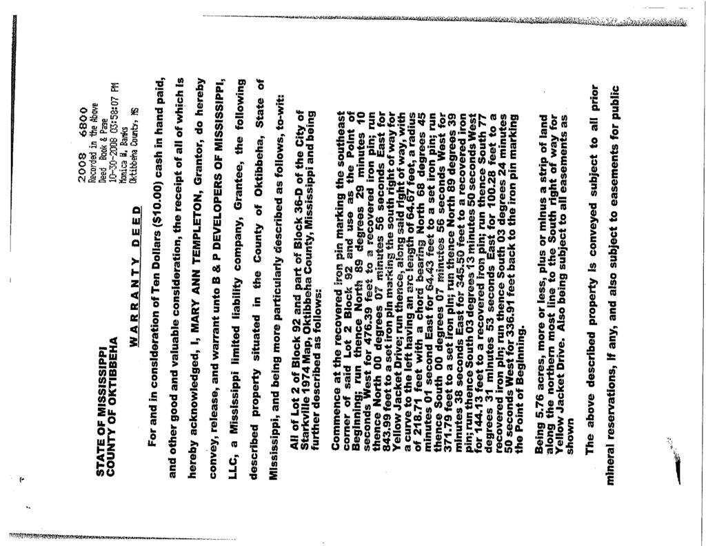
2 THE CITY OF STARKVILLE COMMUNITY DEVELOPMENT DEPT CITY HALL, 101 E. LAMPKIN STREET STARKVILLE, MISSISSIPPI STAFF REPORT TO: Members of the Planning & Zoning Commission FROM: Buddy Sanders ( ext. 119) SUBJECT: RZ 13-14: Rezoning Request to Rezone 4.97 Acres from R-1 Single Family to R-3A Single Family Medium Density off Yellow Jacket Drive DATE: January 10, 2013 BACKGROUND INFORMATION: In October 2008, Mary Ann Templeton sold 5.76 acres to B & P Developers of Mississippi, LLC. Please see Attachment 1. In Deed Book 2008, pages 6801 and 6802, restrictive covenants require all structures to be detached and single family structures, minimum heated floor area of 1,500 square feet, be 70% brick, and a wooden fence along the east boundary of each phase. Other restrictive covenants are also required of the Deed mentioned above. On November 13, 2008, 0.79 acre of 5.76 acres was sold from B & P Developers of Mississippi, LLC, to Robert L. Boyd and Priscilla B. Boyd, creating the boundaries of the current subject 4.97 acre property; Deed Book 2008, page In March 2009, B & P Developers of Mississippi, LLC, requested a rezoning (RZ 09-01) of parcel 102H from R-1 Single Family to R-3 Multi Family. The Planning Commission unanimously recommended approval of the request by B & D Developers of Mississippi, LLC, at their April 14, 2009, Hearing. The Board of Aldermen denied the subject Rezoning request on April 21, 2009, with a vote of 4-3. In July of 2009, B & P Developers of Mississippi, LLC, submitted a second request for a rezoning of parcel 102H from R-1 Single Family to R-3A Single Family Medium Density. The Planning and Zoning Commission recommended denial of the rezoning request to the Board of Aldermen at their August 11, 2009, Hearing. On September 25, 2013, B & P Developers of Mississippi, LLC transferred ownership of parcel 102H became the property of Frank W. Brewer, Sr.; Deed Book 2013, page Also on September 25, 2013, ownership of parcel 102H was divided between Frank W. Brewer, Sr., and Larry T. Herndon; Deed Book 2013, page On November 11, 2013, ownership of 4.97 acres was transferred from Frank W. Brewer, Sr., and Larry T. Herndon to Garden Properties, LLC.
3 The Garden Properties, LLC, property has been listed for sale by Starkville Properties. Staff called Ms. Teresa Brooks who was the listing agent, and Ms. Brooks stated that the property owner decided to take the property off the market and that she would be removing the real estate sign in the near future. NOTIFICATION: Notification by mail to adjacent property owners within 300 feet of parcel 102H took place on December 27, and a notification sign was also placed on Yellow Jacket Drive on the same day. An ad was placed and published in the December 30, 2013, Starkville Daily News. AREA: The subject area is a 4.97 acre flag lot that is now an open field, zoned R-1 Single Family. To the north and east, properties are zoned R-1 Single Family and are single family/residential in use. Property to the south and west are zoned R-1 Single Family but are civic in use with Starkville High School s athletic facilities (allowed as a Conditional Use). Access to the subject property comes off Yellow Jacket Drive with a storage unit business in a B-1 Buffer District, multi-family housing in an R-3 Multi-Family, and C-2 zoning districts north of Yellow Jacket Drive. The applicant has submitted a proposed plat, Attachment 2, illustrating what the possible layout of the subdivision may be. It is important to note that the proposed subdivision, if the applicant s request for a Rezoning is approved, will be required to go through the Development Review Committee, and changes will be required. Please see Attachments 2, 3, 4, and 5. REZONING REQUEST: The applicant is requesting to rezone 4.97 acres from R-1 Single Family to R-3A Single Family Medium Density to allow for garden homes to be constructed. Under the City of Starkville s Permitted and Conditional Use chart in Article VIII, Section M, a single family, detached dwelling is listed as a permitted use in an R-3A zoning district. The minimum lot area allowed in an R-3A zone is 5,000 square feet, which would allow for construction of garden homes. If approved, parcel 102H will become the second R-3A zoned property in the City. Differences between R-1 and R-3A zones are: R-1 Single Family: These [R-1 residential] districts are intended to be composed mainly of single-family residential properties along with appropriate neighborhood facilities, with their character protected by requiring certain minimum yard and area standards to be met. [The following regulations apply to R-1 districts:] 1. See chart for permitted uses. 2. See chart for uses which may be permitted as a special exception. 3. Required lot area and width, yards, building areas and height for 2
4 residences: (a) (b) (c) (d) (e) (f) Minimum lot area: 10,000 square feet. Minimum lot width at the building line: 75 feet. Minimum depth of front yard: 30 feet. Minimum depth of rear yard: 35 feet. Minimum width of each side yard: ten feet. Maximum height of structure: 45 feet. 4. Off-street parking requirements: See Article VIII of this ordinance for requirements for other uses. R-3A Single-Family, Medium-Density: A. Intent. These districts are intended to be composed of single-family dwellings. Appropriate neighborhood supporting facilities are provided for, and the district's open residential character is protected by requiring minimum yard and area standards. R-3A zoning districts shall be more restrictive than the R-3 (multi-family) district but less restrictive than the R-1 (single-family) district. B. Required lot area and width, yards, building areas and height for singlefamily dwellings: Front setback: 25 feet. Side setback: 5 feet. Rear setback: 20 feet. Minimum lot area: 5,000 square feet. Minimum width at building line: 50 feet. Maximum building height: 45 feet. C. Off-street parking. A minimum of three off-street parking spaces shall be provided for each dwelling unit. D. Permitted and conditional uses shall be as follows: 1. The following uses are permitted by right in the R-3A zoning district: a. Single-family dwelling. b. Garden. c. Home occupation 2. The following uses are allowed by conditional use in the R-3A zoning district: a. Church or place of worship. b. Golf course, not including commercial driving ranges; need not be enclosed within structure. c. Public utilities. d. Recreational facilities. E. Comprehensive plan. The R-3A zoning district shall be considered a medium density residential land use classification allowing a maximum gross density of eight dwelling units per acre, as allowed per Table 32 of the City's comprehensive plan 3
5 An R-3A zoning district is considered a medium density residential development. Per Table 32 of the Starkville Comprehensive Plan, a medium density development allows 4 to 8 dwelling units per acre. The maximum gross density that would allow by a zoning change for the subject 4.97 acre lot is 39 single family dwelling units. Please see Attachment 6. The proposed subdivision drawing provided by the applicant illustrates 23 single family lots on 4.97 acres, with a gross density of 4.6 dwelling units per acre. Net density is listed as 3.55 units per acre. However, please note that the drawing is preliminary and is subject to change. STATE REZONING CRITERIA: Per Title 17, Chapter 1, of the Mississippi Code of 1972, as amended, and Appendix A, Article IV, Section A, of the City of Starkville s Code of Ordinances, the Official Zoning Map may be amended only when one or more of the following conditions prevail: 1. Error. There is a Manifest Error in the ordinance and a Public Need to correct the error: There are no errors in need of correction with either the ordinance or zoning map. 2. Change in conditions. Changed or changing conditions in an existing area, or in the planning area generally, or the increased or increasing need for commercial or manufacturing sites or additional subdivision of open land into urban building sites make a change in the ordinance necessary and desirable, and in accord with the public need for orderly and harmonious growth. Consistency with Comprehensive Plan: The Starkville Comprehensive Plan supports infill development to achieve greater utilization of existing municipal service and reduce the need for cost of extension of services. Please see Attachment 7. Land Use Compatibility: While the Starkville High School property to the west and south is zoned R-1 and active recreational/educational facilities are a Conditional Use in an R-1 zone, the same active recreational/educational facilities are also a Conditional Use in an R-3A zone. However, the athletic events and athletic uses will be a more intense use than the proposed garden home subdivision. The R-1 zoned property to the east and north is properly zoned and the use is single family detached homes, which have a lower density than the garden home subdivision being proposed by the applicant. 4
6 To mitigate the effect of existing civic uses on the potential subject development, a buffer yard is recommended. A buffer yard would also mitigate any potential effects on the existing adjacent single family homes. Changed Conditions: The Garden Properties, LLC, property, along with adjacent properties to the east, south and west, are classified as R-1 in the , 2000, 2012, and 2013 zoning maps. Zoning changes to the north and along Yellow Jacket Drive have taken place. These changes are: Zoning Map: R Zoning Map: R Zoning Map: R-3, B-1 & C Zoning Map: R-3, B-1 & C-2 Adequate Public Facilities: Electrical, water, and sewer lines are available in the area. Access for the property is off Yellow Jacket Drive, which is classified as a collector street. Average Daily Traffic (ADT) counts for Yellow Jacket Drive are listed below and in Attachment 8: Site ID ADT ADT ADT ADT ADT ADT ADT ADT ADT ADT Source: Natural Environment: There are no known environmental issues regarding the site. 5
7 Economic Effects: Orderly Development: Public Need: There would be an increase in property tax revenue due to the increase in property value over the current use due to the creation of multiple single family homes. Temporary jobs would be created from construction of a proposed development. Any development proposal for the subject property would be required to conform to the City s land development regulations and would require review by the City s Development Review Committee prior to the commencement of any construction activities. The proposed Rezoning would allow additional housing options for Starkville and would be an infill development, what the Starkville Comprehensive Plan supports. The applicant has submitted a market analysis as their support that there is need in Starkville for a new garden home community. See Attachment 9. PUBLIC INPUT: Community Development has received s and calls concerning the proposed Rezoning to R- 3A, with most of the communications being against the proposed Rezoning. The Pleasant Acres Neighborhood is concerned that an adjacent garden home development would negatively affect their area, which is a traditional neighborhood in an R-1 zoning district. Community Development has received four s against the proposed zoning change. Staff has received one in favor of the zoning change to R-3A. Please see Attachment 10. Mr. Clinton Graves of 812 Pine Circle and Ms. Betty Templeton of 800 Lindley Avenue called Community Development and stated that they were against the Garden Properties, LLC, Rezoning request. STAFF RECOMMENDATION: Based on the above findings, staff recommends approval of the requested zoning change from R-1 Single Family to R-3A Single Family Medium Density of 4.97 acres with the following conditions: 1.) A Type B buffer yard (20 feet wide, 80 planting units per 100 feet) with the exception of the entrance area from Yellow Jacket Drive to the south property line of 102H ) All restrictive covenants in Deed Book 2008, page 6800, are required. The restrictive covenants in Deed Book 2008, page 6800, are: 6
8 A. LAND USE AND BUILDING TYPE: No residence shall be erected on the above-described property except structures constructed of at least 70% brick. B. DWELLING SIZE AND DESIGN: No dwelling size less than 1,500 square feet of heated and cooled area shall be permitted on any developed lot, exclusive of all open porches and storage. All residences shall have an attached double car garage unless the property is rezoned by the City of Starkville to R-3A, in which event front door parking shall be allowed and no garages of any type shall be required. All residences shall have lawn sprinkler systems, landscaping, and sodding of the front and back yards at completion of each residence. D. FENCING: As each phase of the development is initiated, the developer shall construct a wooden privacy fence along the east boundary of each phase. 7
9 Attachment 1
10
11
12
13
14
15 Attachment 2
16
17 Attachment 3
18 ECKFORD RZ13-14 Area Zoning PECAN MS 12 PECAN MS 12 CANAL JACKSON HOWARD YELLOW JACKET Subject Property PINE BARNETT LINDLEY Zoning Areas B-1 Buffer District C-1 Neighborhood Commercial C-2 General Business M-1 Manufacturing R-1 Single Family R-3 Multi-Family R-4-A Single Family High Density R-5 Multi-Family, High-Density. R-6 Mobile Homes/MHP/MHS Feet City of Starkville
19 Attachment 4
20 ECKFORD RZ13-14 Aerial PECAN MS 12 PECAN MS 12 CANAL JACKSON HOWARD YELLOW JACKET Subject Property PINE BARNETT LINDLEY. Feet City of Starkville 2014
21 Attachment 5


22 View From Yellow Jacket Drive North


23 East South

24 West
25 Attachment 6
26 s. Residential growth will be contained and directed into areas where both public water supply and sanitary sewer service can be provided prior to, or as a function of, the development. t. The location of new residential developments should be encouraged to occur in a compact pattern rather than strip or sprawl type development. u. The negative effects of residential sprawl should be minimized through infilling of vacant land. v. Multiple-family developments should be encouraged in areas adequately served by public water supply and sanitary sewer facilities and those sections of the city possessing excellent accessibility, including pedestrian access, to primary thoroughfares, recreational areas, employment centers, shopping facilities, educational facilities, and other community facilities. w. Residential land uses should be properly buffered from incompatible land uses. Higher density residential developments could be used as buffers between commercial/office and low density residential land uses. Adequate buffers should also be provided between residential areas of significantly different densities and from existing pollutions. x. Zoning regulations which provide opportunities for innovation in the design of residential environments shall be encouraged (more planned developments, like PUDs). y. The conservation, rehabilitation, or renewal of existing residential areas shall be encouraged when necessary to maintain a sound residential environment. If a sound residential environment cannot be maintained, then a transition to other suitable uses should be encouraged. z Non-residential land uses should be encouraged within residential neighborhoods only when they provide necessary convenience activities which does not require a service area greater than that of the neighborhood. aa. The need for low and moderate income housing should be recognized through a policy of providing a number of developments throughout the city rather than a policy advocating large concentrations of such housing types. A large portion of the city has been planned for future residential growth and this Plan encourages a wide variety of residential dwelling types to meet the diverse needs of the current and future population of Starkville. The following policies are recommended for developing residential areas: Table 32 Recommended Gross Density, Type of Dwelling Unit, and Utility Standard for Various Types of Residential Development in Starkville CATEGORY GROSS DOMINANT TYPE OF USUAL DENSITY DWELLING UNITS ZONING AGRICULTURE 1 unit per acre Single-family (detached) A-1 LOW 1 4 DUs per acre Single family (detached) R-E, R-1 DENSITY MEDIUM 4-8 DUs per acre Single family and two family; R-2, R-3 DENSITY MF at the greatest densities of this range 87
27 HIGH 8-15 DUs per acre Single-family, zero lot line sf, two- R-4, R-5 DENSITY family, three-family, four-family and multiple family, cluster Note: Higher densities could be achieved through the Planned Unit Development Process. Low Density Goal a. Low Density Urban Residential development should occur at densities greater than one and less than four dwelling units per acre. The dominant dwelling type should be the single-family unit with occasional two-family development at appropriate locations. Cluster development which maintains an overall density of 1 to 4 dwelling units per acre is encouraged. Sanitary sewer services and public water supplies are required for developments in this category. Policies a. The principal land uses intended for this category include single-family detached dwellings. b. Suitable secondary uses, subject to control of potential adverse impacts on household residential uses and public facilities, are activities in the following general use group. (1) Public and private non-profit community services that do not have an extensive impact (like large campus high schools and large church complexes). (2) Utility installations. (3) Low impact non-structural recreational uses in flood prone areas (passive recreation) (4) Customary home occupations (low intensity uses only, i.e., office, sales, etc.) c. The R-E and R-1 districts should dominate the LDR categories. Densities at the high end of the density range should be encouraged to be achieved through the provisions of a Planned Unit Development. Exceptions to Residential Designations The need may arise for commercial services in the more remote areas of the city which are classified LDR. This exception permits limited convenience commercial services in a residential land use category (rezoning to Neighborhood Commercial). This exception is strictly construed so as to serve entire neighborhoods, and not individual subdivisions. The use of this exception to zone commercial property at the entrance of each new subdivision would constitute a misuse of this exception. Consideration may be given to accommodating small-scale offices for transitional purposes and convenience retail activities based on the locational and other criteria contained in this section; conformance of these uses with the Future Land Use Map is not required. The applicable criteria are as follows. 1. Small-scale office activities used principally for transition and buffering between residential uses and incompatible non-residential activities may be considered on their merits in accordance with the following guidelines and criteria. 88
28 Attachment 7
29 Objectives a. To identify the appropriate density of urban residential development in relation to adjacent densities and land uses, capability of existing and proposed utilities, capability of existing/proposed thoroughfares, consistency with community goals, and the natural character of the site and map it on the Future Land Use map. b. To protect the integrity and stability of existing residential areas from encroachment by incompatible land uses and identify the proper spatial relationship between various residential land uses. c. To encourage the creation of unified neighborhoods throughout the community. d. To provide a choice of housing types suitable to surrounding land uses. e. To encourage renewal and stabilization activities in older neighborhoods where it is determined that residential uses are still appropriate. Policies a. Appropriate infilling of developable vacant land should be encouraged and promoted in order to achieve greater utilization of existing municipal services and facilities, to reduce the need for the costly extension of services. b. New residential development should be encouraged and supported in areas contiguous to existing development, where extension of municipal services can be accomplished in an orderly and efficient manner. Leap frog development should be discouraged. c. The intensity of residential development should be appropriately related to the ability of the land to accommodate that development without jeopardizing the health or safety of future occupants, and without adversely affecting the surrounding built and natural environment. d. In residential areas essential services which should be provided as development occurs include roadway access (both local roads and facilities serving the development), public water for both domestic use and fire protection, sanitary sewers, and storm drainage facilities. e. Stable residential areas should be protected and preserved. Stable residential areas will be protected from disruptive uses such as incompatible higher density residential structures, and encroaching industrial and commercial uses. f. Routine maintenance by private property owners is encouraged and the overall condition of the property should be upgraded where necessary to preserve stable development. When necessary, the city shall utilize code enforcement to protect and preserve stable residential areas. Vacant land adjoining stable areas or occupied land to be redeveloped should be utilized for residential, public, or semi-public development. g. Densities of new residential development shall be compatible with surrounding residential areas and a buffer will be provided when there is a significant difference in densities. Reuse of existing residential structures will be designed to occur at a density compatible with surrounding structures. Existing commercial uses and other uses incompatible with the residential character of stable areas are encouraged to be phased out and replaced with compatible uses, except for appropriate planned mixed use areas. h. Proposed residential development which has a significantly different size, height, or mass from adjacent existing development will be discouraged if the proposed differences detract from the use and privacy of the adjacent development. i. Special care should be taken to protect existing historical areas and promote the preservation of the city's unique historical assets. 85
30 j. Maintenance and improvements to the public infrastructure should receive attention necessary to help maintain the stable areas. k. Transitional areas are typically characterized by older housing stock, deferred maintenance, conversions from single-family uses to more intensive uses, and the introduction of incompatible uses. Public and private efforts should focus on upgrading the condition of those residential areas which are in transition. Specific efforts to include area residents in these planning efforts should be made. Transitional residential areas will be protected from disruptive uses such as encroaching industrial and non neighborhood commercial uses. l. Improvement of property through reconstruction and/or an extensive maintenance program by individual owners is encouraged. When necessary, the City shall utilize strict code enforcement to protect and revitalize transitional residential areas. m. Vacant land adjoining transitional areas or occupied land to be redeveloped should be utilized for residential, public, or semi-public development unless specific revitalization plans, adopted by the Planning & Zoning Commission and the Mayor and Board of Aldermen, dictate otherwise. Revitalization plans may consist of a neighborhood plan, historic overlay district, or an economic redevelopment plan. n. Existing commercial and industrial uses and other uses incompatible with the residential character of transitional areas are encouraged to be phased out and replaced with compatible uses. o. Urban residential development should be located on sites offering a diversity of both man-made and natural physical features. Public utility services must be provided for urban residential areas prior to development or as a function of the development. These services should possess adequate capacity, flow, and pressure for the type and density of the potential residential development. Residential land uses should be adequately buffered from incompatible land uses such as industry, commercial centers, agricultural areas, or other potentially incompatible activities (like higher density residential areas). Incompatibility should be determined by: 1. differences in the intensity of each use; 2. the physical relationships among each use; and 3. the external effects generated by each use. Residential areas of substantially different densities should also be adequately buffered by open space or transitional residential uses of an intermediate density. Urban residential development should preserve or create a completely unified neighborhood, having safe, convenient access to school(s), churches, park sites, and other community activity centers and encourage pedestrian and bike access. Small local shopping facilities oriented to the every day needs of the neighborhood residents may be encouraged at appropriate locations. p. Residential development should be located in proximity to major thoroughfares or transit facilities providing direct access to employment, shopping and recreation centers. Urban residential areas should be bounded, but not penetrated by major thoroughfares in order to preserve a unified neighborhood and to provide an interconnection of neighborhoods. The design for traffic circulation in residential developments should provide adequate ingress and egress to neighborhoods without encouraging through traffic. q. Residential development shall be prohibited in areas subject to flooding. r. Residential densities should be compatible with the natural capability of the site to accommodate such development. Soil conditions, geological features, drainage characteristics, and topography should be evaluated as to their effects on density. 86
31 s. Residential growth will be contained and directed into areas where both public water supply and sanitary sewer service can be provided prior to, or as a function of, the development. t. The location of new residential developments should be encouraged to occur in a compact pattern rather than strip or sprawl type development. u. The negative effects of residential sprawl should be minimized through infilling of vacant land. v. Multiple-family developments should be encouraged in areas adequately served by public water supply and sanitary sewer facilities and those sections of the city possessing excellent accessibility, including pedestrian access, to primary thoroughfares, recreational areas, employment centers, shopping facilities, educational facilities, and other community facilities. w. Residential land uses should be properly buffered from incompatible land uses. Higher density residential developments could be used as buffers between commercial/office and low density residential land uses. Adequate buffers should also be provided between residential areas of significantly different densities and from existing pollutions. x. Zoning regulations which provide opportunities for innovation in the design of residential environments shall be encouraged (more planned developments, like PUDs). y. The conservation, rehabilitation, or renewal of existing residential areas shall be encouraged when necessary to maintain a sound residential environment. If a sound residential environment cannot be maintained, then a transition to other suitable uses should be encouraged. z Non-residential land uses should be encouraged within residential neighborhoods only when they provide necessary convenience activities which does not require a service area greater than that of the neighborhood. aa. The need for low and moderate income housing should be recognized through a policy of providing a number of developments throughout the city rather than a policy advocating large concentrations of such housing types. A large portion of the city has been planned for future residential growth and this Plan encourages a wide variety of residential dwelling types to meet the diverse needs of the current and future population of Starkville. The following policies are recommended for developing residential areas: Table 32 Recommended Gross Density, Type of Dwelling Unit, and Utility Standard for Various Types of Residential Development in Starkville CATEGORY GROSS DOMINANT TYPE OF USUAL DENSITY DWELLING UNITS ZONING AGRICULTURE 1 unit per acre Single-family (detached) A-1 LOW 1 4 DUs per acre Single family (detached) R-E, R-1 DENSITY MEDIUM 4-8 DUs per acre Single family and two family; R-2, R-3 DENSITY MF at the greatest densities of this range 87
32 Attachment 8


33 Source: Mississippi Department of Transportation Site:
34 Attachment 9
35
36
37
38
39
40
41
42
43
44
45
46
47
48
49
50
51
52
53
54
55
56
57
58
59
60
61 Attachment 10
62
63
64
65
66
67
68
69
70
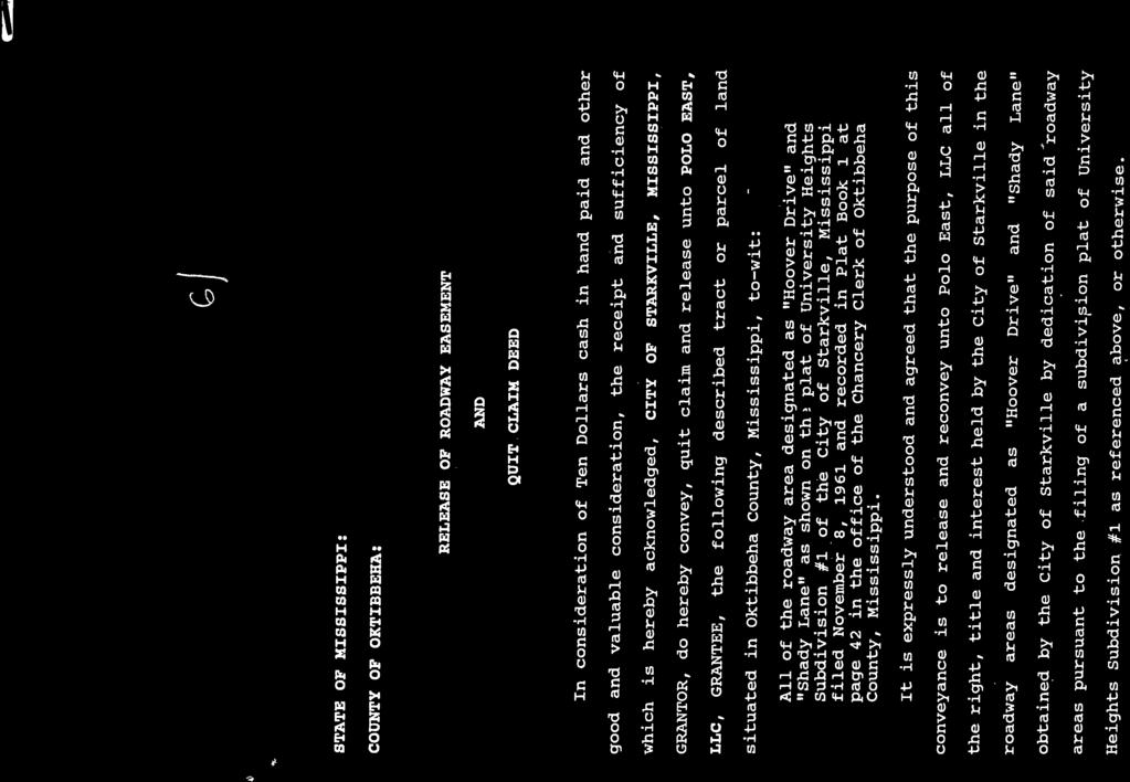
71 THE CITY OF STARKVILLE COMMUNITY DEVELOPMENT DEPT CITY HALL, 101 E. LAMPKIN STREET STARKVILLE, MISSISSIPPI STAFF REPORT TO: Members of the Planning & Zoning Commission FROM: Buddy Sanders City Planner ( ext. 119) CC: PP Cottages At Starkville Station DATE: December 10, 2014 BACKGROUND INFORMATION: Cottages at Starkville Station, LLC, is requesting Preliminary Plat approval of a 22 lot subdivision west of the Starkville Station RV Park. Please see Attachments 1 and 2. Zoning for the property is R-5 (Multi-Family, High-Density). Lot requirements for an R-5 zone are: Required lot area and width, yards, building areas, and height for residences: (a) (b) (c) (d) (e) (f) Minimum lot area, per unit: 1,800 square feet. Minimum lot width at building line: Single-family and multi-family dwelling of less than eight units: 50 feet. Townhouse dwelling: 16 feet. Multi-family dwellings of eight units or more: 100 feet. Minimum depth of front yard: 25 feet. Minimum width of side yard: Five feet. Minimum depth of rear yard: 20 feet. Maximum height of structure: 45 feet. Lots, as illustrated, of the proposed Cottages at Starkville Station meet the requirements of an R-5 zoning district. Please note that the areas illustrated as Right of Way in the PP Area Zoning and PP Aerial maps is not Public Right of Way. In 1998 the City issued a Release of Roadway Easement and Quit Claim Deed for both Hoover Drive and Shady Lane. Please see Attachment 3. PLAT PROPOSAL General Information The applicant is requesting Preliminary Plat approval of a 22 lot subdivision totaling 4.03 acres. Please see Attachment 4.
72 Easements and Dedications The proposed lots will front an extension of RV Way and a new street to be named Station Lane. RV Way takes access off Lincoln Green Street. There is an existing 10-foot sewer/utility easement along the western property line and an existing gas/utility easement along the northern property line. The applicant will have 10-foot utility easements fronting all new streets of the proposed subdivision, and electrical, water, and sewer services are available. Findings and Comments The Cottages at Starkville Station Preliminary Plat was reviewed by the Development Review Committee on December 19. There are no significant concerns regarding the subject Preliminary Plat, but the Engineering Division did note that upstream storm water will need to be routed through the development in some fashion without it going through the detention facility. CONCLUSIONS Staff recommends approval of the Cottages at Starkville Station Preliminary Plat. It is recommended that the following conditions be issued with recommendation of approval: 1. Additional easements may be required. 2. Upstream storm water will need to be routed through the development in some fashion without it going through the detention facility. 3. Infrastructure drawings will be required upon Preliminary Plat approval prior to construction. 2
73 Attachment 1
74 PP13-07 Aerial Hwy 12 Southdale Blackjack Rd River Rd. Subject Property. Feet City of Starkville 2014
75 Attachment 2
76 PP13-07 Area Zoning Hwy 12 Southdale Blackjack Rd River Rd. Subject Property Zoning Areas R-3 Multi-Family R-5 Multi-Family, High-Density B-1 Buffer District C-2 General Business R-1 Single Family. Feet City of Starkville
77 Attachment 3

78
79
80 Attachment 4
81
82 UNAPPROVED MINUTES OF THE PLANNING & ZONING COMMISSION MEETING OF DECEMBER 10, 2013 THE CITY OF STARKVILLE, MISSISSIPPI The Planning & Zoning Commission of the City of Starkville, Mississippi, held its regularly scheduled meeting in the City Hall Courtroom at 101 E. Lampkin Street, Starkville, Mississippi, commencing at 5:30 PM. The meeting was called to order by Commission Chair Jerry Emison. Present were Commissioners Michael Brooks, Jerry Emison, Dora Herring, James Hicks, Ira Loveless, John Moore, and Jeremy Murdock. Attending the Commissioners were City Attorney Chris Latimer, City Planner Buddy Sanders, Director of Finance Taylor Adams, and Recording Secretary Bill Green. A CONSIDERATION OF THE WRITTEN AGENDA Commission Chair Jerry Emison brought a suggestion before the Commission, to consider the placement of the Approval of the Minutes to before the Planner s Report and after New Business instead of its current placement at the front of the Agenda, so that citizens attending the meeting would not be inconvenienced by having to wait for their needs to be heard. Upon the motion of Commissioner Herring to amend the written Agenda as suggested, seconded by Commissioner Moore, the Commission voted unanimously to approve the written Agenda dated December 10, 2013, as amended. CITIZEN COMMENTS Chair Emison asked if any member of the public cared to address the Commission, reminding them that there is a public hearing on the Agenda and comments regarding proposed items would be called for at the appropriate time. No citizen comments were received. NEW BUSINESS RZ 13-13: A PUBLIC HEARING REQUESTED BY THE CITY OF STARKVILLE TO REZONE ACRES WEST OF THE INTERSECTION OF SOUTH MONTGOMERY STREET AND WEDGEWOOD ROAD FROM A-1 AGRICULTURAL TO B-1 BUFFER DISTRICT, WARD 3 Chair Emison opened the Public Hearing and asked the City Planner to introduce item RZ 13-13, a Public Hearing requested by the City of Starkville to rezone acres west of the intersection of South Montgomery Street and Wedgewood Road from A-1 Agricultural to B-1 Buffer District, Ward 3. Page 1 of 6
83 City Planner Buddy Sanders stated that Ramsey Partners, LP, is requesting the rezoning change because of their plans to place an assisted-living facility in the proposed location. The surrounding areas (across the street) consist of subdivisions and a country club, which are zoned R-1 and R-4. For a zoning change in Mississippi to occur, one of two criteria has to apply: Manifest Error in Mapping or Change of Condition. There are no mapping errors, and although zoning hasn t changed, conditions have changed: the residential subdivisions in the area have been developed over the past 20 years, a new traffic light at South Montgomery Street and Poor House Road was installed (the only traffic light existing outside the city limits), water and electrical lines are already available along South Montgomery, and city sewer lines are available southeast of subject site; thus, the criterion for change in zoning applies. While the facility is commercial in nature, it is primarily residential, and Mr. Sanders stated that the zoning change was appropriate for these acres. The Staff recommends approval of this request for a zoning change from A-1 to B-1 with the following conditions: 1. The acres will be required to be a separate parcel as described in attachment four, the land title survey. [This phrase was added after the minutes were completed.] 2. A copy is to be provided of the Recorded Deed to Community Development. 3. Use of the property is limited to a retirement/assisted-living use. Chair Emison called for discussion on the Public Hearing. The applicant, Saunders Ramsey, spoke of the need for a retirement community in Starkville, and on the behalf of the developer, they have identified that it falls within a five-mile radius of the hospital, and the location of the development meets demographic needs. Chair Emison called for questions, and there being none, he called for the public to speak on this matter. Alex Harris, who owns a home and land around the proposed area, is supportive of the development but has three questions regarding what was mentioned at the last board meeting: 1) Is this development consistent with the development of South Montgomery in changing the zone to light commercial; 2) Has the increase of traffic been taken into consideration fully; 3) Has a Certificate of Need been granted to the developer by the State of Mississippi. Also, Mr. Harris noted that at the November meeting, this board suggested that the Applicant contact the surrounding neighbors regarding this development, and he asked if this step had been taken. Chair Emison called for others who want to speak on this matter in a Public Hearing. Cindy Harris, wife of Alex Harris, came forward asking if others had been notified of the meeting regarding the Applicant s rezoning request. Mr. Sanders responded saying that everyone within 300 feet of all the Ramsey s property had been notified, which is beyond the requirement of 160 feet of the rezoning area. In addition, there was a notification of Public Hearing published in the Starkville Daily News 15 days prior to the hearing, and a sign was placed on the property of the proposed rezoning area; all the requirements for notification have been met. Rob Tatum, the developer of the assisted-living project, answered Mr. Harris s third question, stating that there is no Certificate of Need, as required by the State of Mississippi, but a site approval was granted from the Mississippi Department of Health. Page 2 of 6
84 Saunders Ramsey addressed the concerns regarding the development: the development is for retirement use only; the traffic study was taken into account and has shown that the traffic in the Wedgewood area is a Level A, the best possible. Regarding future use, widening of South Montgomery is planned, and the development is to allow more than enough buffer for widening to occur. The development welcomes a limited use for retirement and assisted living only. Upon the recommendation by the Staff to approve the requested zoning change from A-1 Agricultural to B-1 Buffer of acres, Chair Emison suggested that a fourth condition be met in addition to the three recommended by Staff: 4) Staff should establish the clear legal definition of the plat that conforms to the site as it has been identified before this matter goes before the Board of Alderman. City Attorney Latimer observed that a legal description already exists on the land survey for the property and would suffice for the fourth condition. After discussion and clarification regarding whether condition one would change if the Applicant should request rezoning as a plat versus subdividing a parcel, Commissioner Hicks suggested that the phrase as described in attachment four, the land title survey be added to condition one, which was supported by Mr. Latimer. Commissioner Murdock moved to recommend approval of the rezoning request of RZ on the basis of Change of Condition in the neighborhood and Public Need, with the three conditions asserted by the Staff and amended by the Commission, which was seconded by Commissioner Brooks. The motion carried unanimously. FP 13-06B: A PUBLIC HEARING REQUESTED FOR AN ADDITIONAL LOT TO THE MILL AT MSU, LOCATED AT THE INTERSECTION OF MILL AND RUSSELL STREETS, T-6 ZONING DISTRICT, WARD 4 Next there came before the Commission item FP 13-06B: a public hearing regarding a request for an additional lot to The Mill at MSU, located at the intersection of Mill and Russell Streets, T-6 Zoning District, Ward 4. Chair Emison, recused himself from this portion of the meeting and left the room after turning the meeting over to Commissioner Herring, who opened the Public Hearing. City Planner Buddy Sanders presented the request of an addition of a lot, Lot 1A, to The Mill at MSU. Mr. Sanders stated that although the Board of Aldermen have already approved the Final Plat, with conditions, there were some changes to the lot due to an imminent deadline in financing, and therefore re-approval is required. Staff recommends approval with the same conditions, Item 11 being the only change. Commissioner Herring called for a spokesperson on behalf of the Applicant, and Mark Castleberry came forward to answer questions. Commissioner Hicks asked if the designation of the Final Plat had been added to the Plat; Mr. Castleberry answered in the affirmative that the designation had been added. After discussion, Mr. Latimer summarized that the Applicant is expressly recognizing Page 3 of 6
85 Lot 1A as a separate and distinct piece of property, and to avoid leaving Lot 1B undesignated from the result of the subdivision of Lot 1, he recommended that Lot 1B be recognized as a new piece of property as well. Commissioner Herring called for the public to speak, and after no comments were brought forth, the Public Hearing was closed. Following the Staff recommendation to recognize Lot 1A and 1B together in the revised Final Plat, Commissioner Murdock expressed concerns about the long-term implications for the potential development of land facing Russell Street if the land were separated from the protection of the Cooley Building s National Historic Register status. After discussion among the Commissioners, the Applicant, the City Attorney, the City Planner, and the Director of Finance, it was agreed that a new legal description combining Lot 1A and 1B as Lot 1 would eliminate concern. Commissioner Hicks raised concern regarding proper procedure with last-minute changes, and City Attorney Latimer recommended that a clean document be created that reflects the revised legal reconfiguration of the combined lots, without the delineation of the dividing line, before submitting the proposal to the Board of Aldermen. Commissioner Murdock made a motion to approve, with the revision of the legal description of the Final Plat to recognize Lot 1 reconfigured as a combination of Lot 1A and Lot 1B with no delineation. Commissioner Brooks seconded the motion, which passed unanimously. After the vote, Chair Emison reentered the room, and Commissioner Herring relinquished control of the meeting. CONSIDERATION/RECONSIDERATION FOR APPROVAL OF THE MINUTES OF THE MEETINGS OF JULY 24, 2013; AUGUST 13, 2013; SEPTEMBER 10, 2013; OCTOBER 8, 2013; AND NOVEMBER 12, 2013 Chair Emison called for a motion to reconsider approval of the July 24, 2013, minutes. Commissioner Loveless made the motion, with Commissioner Moore seconding, and the Commission voted unanimously to reconsider the minutes of July 24, Suggested changes to the minutes were: 1) to add subsequently excused in the first paragraph on page 1 after Mr. Murdock s name; 2) to remove through Maxine Hamilton at the end of the first paragraph of page 2; 3) to replace the word us with the Commission in the fourth paragraph on page 2; 4) to delete the letter t in the last paragraph on page 2; and 5) to delete the words after the word Table in the last sentence before the Planner s Report. Commissioner Loveless moved to approve the minutes as amended, seconded by Commissioner Moore, and the resulting vote was unanimous with the exception of Commissioner Murdock, who abstained. Page 4 of 6
86 A motion was called for to reconsider approval of the August 13, 2013, minutes. Commissioner Murdock made the motion, with Commissioner Moore seconding, and the Commission unanimously voted to reconsider the approval. Suggested changes for the minutes were: 1) to move the first item of new business to the end of the New Business; 2) to amend the first line of the third paragraph on page 2 to read presented the matter concerning Mr. Robert Rogers s request instead of presented the matter for Mr. Roberts Rogers ; 3) to delete the third paragraph on page 3; 4) to delete the word Apparently from the last sentence of what is now the third paragraph on page 3; 5) to add The motion carried unanimously among Commissioners present. to the end of the first full paragraph on page 3; 6) to delete the paragraph beginning After much discussion, and no finding of errors. Commissioner Murdock moved to accept the minutes as amended, which was seconded by Commissioner Hicks, and the Commission voted unanimously to approve the minutes of August 13, 2013, as amended, with the proviso that Staff will note who made the motions and voted. Chair Emison called for a motion to reconsider approval of the minutes of September 10, Commissioner Hicks made the motion, with Commissioner Moore seconding, which was unanimously approved by the Commission. Suggested changes for the minutes were: 1) to change on page 2, the fourth paragraph, the words has confusion in to disagrees with ; 2) on page 3, paragraph 2, to add the word to between the words over and the and to add the phrase and departed the meeting at the end of the sentence. 3) add item number CU to the Mill Development Parking Deck and delete conditional before exception ; 4) to ensure that the first two instructions in the fifth paragraph on page 2 were inserted into the list of conditions; 5) to remove all references to Conditional Use in the CU section and delete the number 6 on page 4 in the last requirement and adjusting the introductory text as The relevant criteria for the Use by Exception is in the Transect Section ; 6) to change the name from Dell Partner Architects to Dale Partner Architects in the last paragraph on page 4; 7) to change, in the third paragraph on page 5, private parking garage to public parking garage ; 8) to change the phrase from 37 to 50 feet to from 50 feet to 37 feet in the first numbered paragraph on page 6. Commissioner Murdock moved to approve the minutes as amended, seconded by Commissioner Hicks, and the resulting vote was unanimous. Chair Emison introduced the minutes from October 8, 2013, to be considered for approval. Suggested changes to the minutes were: 1) to add and departed the hearing room after the word deliberation in the first paragraph on page 2. Commissioner Murdock moved to approve the minutes as amended, seconded by Commissioner Hicks, and the resulting vote was unanimous. Chair Emison introduced the minutes from November 12, 2013, to be considered for approval. Suggested changes to the minutes were: 1) to change, in the third heading on page 1, the words AN ORDER APPROVING to CONSIDERATION OF ; 2) to add on page 3 the following sentence to the end of the last paragraph: The Commission took no action on the October 8 minutes pending a comprehensive review by City Staff of the accuracy and completeness of these and other Page 5 of 6
87 minutes. ; 3) to delete the last sentence before the heading on page 3; 4) to delete the sentence that begins with City Attorney Latimer suggested that statistics and empirical evidence should be... on page 2 in the second paragraph; 5) to delete the last sentence on page 4. Commissioner Hicks moved to approve the minutes from November 12, 2013, as amended, seconded by Commissioner Moore, and the resulting vote was unanimous, with Commissioner Murdock abstaining. PLANNER S REPORT Commissioner Herring asked Mr. Sanders if he had researched the Zoning at the Research Park, and he responded in the affirmative, and that after his findings, he and Mr. Adams indicated a desire to move forward with possible rezoning based on the discovery at the beginning of the year. ADJOURNMENT Commissioner Emison called for a motion to adjourn. Commissioner Herring made the motion, seconded by Commissioner Hicks, to adjourn the meeting at 7:23 PM. The next regularly scheduled meeting will be Tuesday, January 14, 2013, at 5:30 PM in the City Hall Courtroom. Page 6 of 6
A. CONSIDERATION OF THE UNAPPROVED MINUTES OF NOVEMBER 13, 2018
 I. CALL TO ORDER OFFICIAL AGENDA PLANNING & ZONING COMMISSION CITY OF STARKVILLE, MISSISSIPPI MEETING OF TUESDAY, DECEMBER 11, 2018 1ST FLOOR CITY HALL COURT ROOM 110 WEST MAIN STREET AT 5:30 PM II. III.
A. Consideration of the unapproved December 8, 2015 minutes B. Consideration of the unapproved January 12, 2016 minutes
 OFFICIAL AGENDA PLANNING & ZONING COMMISSION CITY OF STARKVILLE, MISSISSIPPI MEETING OF TUESDAY, April 12, 2016 CITY HALL - COURT ROOM, 110 West Main Street, 5:30 PM I. CALL TO ORDER II. III. IV. PLEDGE
OFFICIAL AGENDA PLANNING & ZONING COMMISSION CITY OF STARKVILLE, MISSISSIPPI
 OFFICIAL AGENDA PLANNING & ZONING COMMISSION CITY OF STARKVILLE, MISSISSIPPI MEETING OF TUESDAY, March 11, 2014 CITY HALL - COURT ROOM, 101 E. LAMPKIN STREET, 5:30 PM I. CALL TO ORDER II. III. IV. PLEDGE
A. CONSIDERATION OF THE UNAPPROVED MINUTES OF DECEMBER 11, 2018
 I. CALL TO ORDER OFFICIAL AGENDA PLANNING & ZONING COMMISSION CITY OF STARKVILLE, MISSISSIPPI MEETING OF TUESDAY, JANUARY 8, 2018 1ST FLOOR CITY HALL COURT ROOM 110 WEST MAIN STREET AT 5:30 PM II. III.
3.1. OBJECTIVES FOR RESIDENTIAL LAND USE DESIGNATIONS GENERAL OBJECTIVES FOR ALL RESIDENTIAL DESIGNATIONS
 3. RESIDENTIAL LAND USE DESIGNATIONS INTRODUCTION The Residential land use designations provide for housing and other land uses that are integral to, and supportive of, a residential environment. Housing
Planning Department Oconee County, Georgia
 Planning Department Oconee County, Georgia STAFF REPORT REZONE CASE #: 6985 DATE: October 31, 2016 STAFF REPORT BY: Andrew C. Stern, Planner APPLICANT NAME: Williams & Associates, Land Planners PC PROPERTY
ARTICLE 15 - PLANNED UNIT DEVELOPMENT
 Section 15.1 - Intent. ARTICLE 15 - PLANNED UNIT DEVELOPMENT A PUD, or Planned Unit Development, is not a District per se, but rather a set of standards that may be applied to a development type. The Planned
ARTICLE B ZONING DISTRICTS
 ARTICLE B ZONING DISTRICTS Sec. 8-3021 Established. In order to protect the character of existing neighborhoods; to prevent excessive density of population in areas which are not adequately served with
Appendix J - Planned Unit Development (PUD)
") Appendix J - Planned Unit Development (PUD) Intent and Purpose The purpose of the PUD is: 1. To provide development that is consistent with the Comprehensive Land Use Plan and promote the goals and objectives
Appendix J - Planned Unit Development (PUD) Intent and Purpose The purpose of the PUD is: 1. To provide development that is consistent with the Comprehensive Land Use Plan and promote the goals and objectives
Midwest City, Oklahoma Zoning Ordinance
 2010 Midwest City, Oklahoma Zoning Ordinance 9/2/2010 Table of Contents Section 1. General Provisions... 5 1.1. Citation... 5 1.2. Authority... 5 1.3. Purpose... 5 1.4. Nature and Application... 5 1.5.
PIN , Part 1, Plan SR-713 in Lot 2, Concession 5, Township of McKim (1096 Dublin Street, Sudbury)
") STAFF REPORT Applicant: Dalron Construction Limited Location: PIN 02124-0103, Part 1, Plan SR-713 in Lot 2, Concession 5, Township of McKim (1096 Dublin Street, Sudbury) Official Plan and Zoning By-law:
STAFF REPORT Applicant: Dalron Construction Limited Location: PIN 02124-0103, Part 1, Plan SR-713 in Lot 2, Concession 5, Township of McKim (1096 Dublin Street, Sudbury) Official Plan and Zoning By-law:
Town of Waxhaw Board of Commissioners. Waxhaw Police Department Community Meeting Room Tuesday January 12, 2016
 Town of Waxhaw Board of Commissioners Waxhaw Police Department Community Meeting Room Tuesday January 12, 2016 Petition RZ-003994-2015 A request by the Town of Waxhaw Planning & Community Development Department,
PLANNED UNIT DEVELOPMENT (PUD)
") SECTION 38.01. ARTICLE 38 PLANNED UNIT DEVELOPMENT (PUD) Purpose The purpose of this Article is to implement the provisions of the Michigan Zoning Enabling Act, Public Act 110 of 2006, as amended, authorizing
SECTION 38.01. ARTICLE 38 PLANNED UNIT DEVELOPMENT (PUD) Purpose The purpose of this Article is to implement the provisions of the Michigan Zoning Enabling Act, Public Act 110 of 2006, as amended, authorizing
EDGERTON CITY HALL PLANNING COMMISSION MEETING REGULAR SESSION March 12, 2019
 EDGERTON CITY HALL PLANNING COMMISSION MEETING REGULAR SESSION The met in regular session with Chair John Daley calling the meeting to order at 7:00 p.m. All present participated in the Pledge of Allegiance.
Glades County Staff Report and Recommendation REZONING
 Glades County Staff Report and Recommendation REZONING CASE NUMBER: RZ15-01 DATE: October 2, 2015 CASE TYPE: Application for Rezoning REQUEST: J.J. Wiggins Memorial Trust is requesting a rezoning of 22.1±
THE REDEVELOPMENT PLAN
 PAGE 37 THE REDEVELOPMENT PLAN FUTURE LAND USE The Silver Terrace Redevelopment Area is currently designated as Redevelopment Area #4 on the City of Delray Beach Future Land Use Map (FLUM). This designation
FUTURE LAND USE. City of St. Augustine Comprehensive Plan EAR-Based Amendments
 FUTURE LAND USE City of St. Augustine Comprehensive Plan EAR-Based Amendments Future Land Use Element FLU Goal To create an environment within the City and adjacent areas in which its residents have the
CHAPTER 14 PLANNED UNIT DEVELOPMENTS
 9-14-1 9-14-1 CHAPTER 14 PLANNED UNIT DEVELOPMENTS SECTION: 9-14-1: Purpose 9-14-2: Governing Provisions 9-14-3: Minimum Area 9-14-4: Uses Permitted 9-14-5: Common Open Space 9-14-6: Utility Requirements
A. CONSIDERATION OF THE UNAPPROVED MINUTES SEPTEMBER 12, 2017 B. CONSIDERATION OF THE UNAPPROVED MINUTES NOVEMBER 1, 2017
 I. CALL TO ORDER OFFICIAL AGENDA PLANNING & ZONING COMMISSION CITY OF STARKVILLE, MISSISSIPPI MEETING OF TUESDAY, NOVEMBER 14, 2017 CITY HALL - COURT ROOM, 110 WEST MAIN STREET AT 5:30 PM II. III. IV.
TOWN OF ORO VALLEY PLANNING & ZONING COMMISSION MEETING DATE: December 6, 2011
 PLANNING & ZONING COMMISSION MEETING DATE: December 6, 2011 TO: FROM: SUBJECT: PLANNING & ZONING COMMISSION Matt Michels, Senior Planner mmichels@orovalleyaz.gov; tel. 229-4822 Public Hearing: Rancho de
The following regulations shall apply in the R-E District:
 "R-E" RESIDENTIAL ESTATE DISTRICT (8/06) The following regulations shall apply in the R-E District: 1. Uses Permitted: The following uses are permitted. A Zoning Certificate may be required as provided
6. RESIDENTIAL ZONE REGULATIONS
 6. RESIDENTIAL ZONE REGULATIONS PART 6A PURPOSE OF CHAPTER (1) The purpose of this Chapter is to provide detailed regulations and requirements that are relevant only to residential zones and specific residential
ARTICLE 3: Zone Districts
 ARTICLE 3: Zone Districts... 3-1 17.3.1: General...3-1 17.3.1.1: Purpose and Intent... 3-1 17.3.2: Districts and Maps...3-1 17.3.2.1: Applicability... 3-1 17.3.2.2: Creation of Districts... 3-1 17.3.2.3:
THE AREA PLAN COMMISSION OF ST. JOSEPH COUNTY, IN AGENDA
 THE AREA PLAN COMMISSION OF ST. JOSEPH COUNTY, IN AGENDA Tuesday, June 20, 2017 Fourth-Floor Council Chambers 3:30 p.m. County-City Building, South Bend, IN PUBLIC HEARINGS: 1. Rezonings: A. A combined
RP-2, RP-3, RP-4, AND RP-5 PLANNED RESIDENTIAL DISTRICTS
 6.10 - RP-2, RP-3, RP-4, AND RP-5 PLANNED RESIDENTIAL DISTRICTS 6.10.1 GENERAL DESCRIPTION: 6.10.1.1 The regulations established in this Section are intended to provide optional methods of land development
Marion County Board of County Commissioners
 Marion County Board of County Commissioners Date: 12/29/2015 P&Z: 12/28/2015 BCC: 1/12/2016 Item Number 160113Z Type of Application Rezoning Request From: A-1 (General Agriculture) To: PUD (Planned Unit
PLANNING COMMISSION REPORT Regular Agenda -Public Hearing Item
 PDP-13-00518 Item No. 3B- 1 PLANNING COMMISSION REPORT Regular Agenda -Public Hearing Item PC Staff Report 2/24/14 ITEM NO. 3B PRELIMINARY DEVELOPMENT PLAN FOR HERE @ KANSAS; 1101 INDIANA ST (SLD) PDP-13-00518:
Financial Impact Statement There are no immediate financial impacts associated with the adoption of this report.
 STAFF REPORT Planning and Development Department Subject: Application by RYC Property to rezone a portion of lands on John Murray Dr. and Megan Lynn Dr. from R2 to R3 and to enter into a Development Agreement
Town of Cary, North Carolina Rezoning Staff Report 14-REZ-31 Cary Park PDD Amendment (Waterford II) Town Council Meeting January 15, 2015
 Town Council Meeting January 15, 2015") Town of Cary, North Carolina Rezoning Staff Report 14-REZ-31 Cary Park PDD Amendment (Waterford II) Town Council Meeting January 15, 2015 REQUEST To amend the Town of Cary Official Zoning Map by amending
Town of Cary, North Carolina Rezoning Staff Report 14-REZ-31 Cary Park PDD Amendment (Waterford II) Town Council Meeting January 15, 2015 REQUEST To amend the Town of Cary Official Zoning Map by amending
Chapter 1107: Zoning Districts
 Chapter 1107: Zoning Districts 1107.01 Establishment of Zoning Districts (a) Districts Established In order to carry out the purpose of this code, the City is hereby divided into the zoning districts established
Article Optional Method Requirements
 Article 59-6. Optional Method Requirements [DIV. 6.1. MPDU DEVELOPMENT IN RURAL RESIDENTIAL AND RESIDENTIAL ZONES Sec. 6.1.1. General Requirements... 6 2 Sec. 6.1.2. General Site and Building Type Mix...
REZONING APPLICATION INSTRUCTIONS
 REZONING APPLICATION INSTRUCTIONS All required information, as stated on the Rezoning Application Checklist, must be included to qualify as a complete application. Upon receipt, staff will review the application
ACTION FORM BRYAN CITY COUNCIL
 ACTION FORM BRYAN CITY COUNCIL DATE OF COUNCIL MEETING: July 8, 2014 DATE SUBMITTED: June 17, 2014 DEPARTMENT OF ORIGIN: Development Services SUBMITTED BY: Maggie Dalton MEETING TYPE: CLASSIFICATION: ORDINANCE:
Hal Simmons Planning Director Boise City Planning and Development Services. CAR / 1689 South Entertainment Avenue
 MEMORANDUM MEMO TO: FROM: Mayor and Boise City Council Hal Simmons Planning Director Boise City Planning and Development Services DATE: November 15, 2008 RE: CAR08-00019 / 1689 South Entertainment Avenue
REPORT OF THE PLANNING AND DEVELOPMENT DEPARTMENT FOR APPLICATION FOR REZONING ORDINANCE TO PLANNED UNIT DEVELOPMENT SEPTEMBER 22, 2016
 BEL REPORT OF THE PLANNING AND DEVELOPMENT DEPARTMENT FOR APPLICATION FOR REZONING ORDINANCE 2016-576 TO PLANNED UNIT DEVELOPMENT SEPTEMBER 22, 2016 The Planning and Development Department hereby forwards
Appendix A: Guide to Zoning Categories Prince George's County, Maryland
 Appendix A: Guide to Zoning Categories Prince George's County, Maryland RESIDENTIAL ZONES 1 Updated November 2010 R-O-S: Reserved Open Space - Provides for permanent maintenance of certain areas of land
Article 7: Residential Land Use and Development Requirements
 Article 7: Residential Land Use and Section 701: Statement of Intent (A) (B) (C) The intent of Article 7 is to develop certain land use and development requirements for the residential uses within Cumru
9. REZONING NO Vicinity of the northwest corner of 143 rd Street and Metcalf Avenue
 9. REZONING NO. 2002-15 Vicinity of the northwest corner of 143 rd Street and Metcalf Avenue 1. APPLICANT: Andrew Schlagel is the applicant for this request. 2. REQUESTED ACTION: The applicant is requesting
Nassau County Department of Planning & Economic Opportunity Nassau Place Yulee, Florida 32097
 Nassau County Department of Planning & Economic Opportunity 96161 Nassau Place Yulee, Florida 32097 APPLICATION AND INSTRUCTIONS FOR FUTURE LAND USE MAP AMENDMENT (TEN (10) ACRES OR MORE) NOTICE: Florida
ORDINANCE NO. 208 BE IT ORDAINED BY THE CITY COUNCIL OF THE CITY OF UNIVERSITY HEIGHTS, JOHNSON COUNTY, IOWA:
 ORDINANCE NO. 208 AN ORDINANCE AMENDING ORDINANCE NO. 79 (ZONING) TO CREATE A COMMERCIAL HOTEL ZONE AND PERMIT DEVELOPMENT PURSUANT TO A COMMERCIAL HOTEL PUD BE IT ORDAINED BY THE CITY COUNCIL OF THE CITY
PLANNING COMMISSION REPORT Regular Agenda - Public Hearing Item
 Z-11-25-09; Z-11-26-09; Z-11-28-09 Item No. 2-1 PC Staff Report 3/28/11 PLANNING COMMISSION REPORT Regular Agenda - Public Hearing Item ITEM NO. 2A RM32 TO MU;.19 ACRES; 1340 TENNESSEE ST (MJL) Z-1-1-11:
PLANNING COMMISSION STAFF REPORT
 PLANNING COMMISSION STAFF REPORT West Capitol Hill Zoning Map Amendment Petition No. PLNPCM2011-00665 Located approximately at 548 W 300 North Street, 543 W 400 North Street, and 375 N 500 West Street
PLANNED UNIT DEVELOPMENT & SUBDIVISION STAFF REPORT Date: April 18, 2019
 PLANNED UNIT DEVELOPMENT & SUBDIVISION STAFF REPORT Date: April 18, 2019 DEVELOPMENT NAME SUBDIVISION NAME Springhill Village Subdivision Springhill Village Subdivision LOCATION 4350, 4354, 4356, 4358,
CLEARFIELD CITY COUNCIL AGENDA AND SUMMARY REPORT July 31, 2018 SPECIAL POLICY SESSION
 CLEARFIELD CITY COUNCIL AGENDA AND SUMMARY REPORT July 31, 2018 SPECIAL POLICY SESSION Meetings of the City Council of Clearfield City may be conducted via electronic means pursuant to Utah Code Ann. 52-4-207
UPPER MOUNT BETHEL TOWNSHIP NORTHAMPTON COUNTY, PENNSYLVANIA
 UPPER MOUNT BETHEL TOWNSHIP NORTHAMPTON COUNTY, PENNSYLVANIA JOINDER DEED / LOT CONSOLIDATION TOWNSHIP REVIEW PROCESS When accepting proposed Joinder Deeds / Lot Consolidations, review the Joinder Deed
Staff Report: Date: Applicant: Property Identification: Acreage of Request: Current Zoning of Requested Area: Requested Action: Attached:
 Staff Report: Completed by Jeff Palmer Director of Planning & Zoning Date: November 7, 2018, Updated November 20, 2018 Applicant: Greg Smith, Oberer Land Developer agent for Ronald Montgomery ET AL Property
Staff Report: Date: Applicant: Property Identification: Acreage of Request: Current Zoning of Requested Area: Requested Action: Attached:
 Staff Report: Completed by Jeff Palmer Director of Planning & Zoning Date: November 7, 2018 Applicant: Greg Smith, Oberer Land Developer agent for Ronald Montgomery ET AL Property Identification: Frontage
GENERAL DESCRIPTION STAFF RECOMMENDATION IMPLEMENTATION REQUIREMENTS
 Application No.: 891418 Applicant: AREA-WIDE MAP AMENDMENT Rezone two parcels from Moderate Density Single Family (MSF) to Neighborhood Center (NC) and Employment Center (EC). Charles Bitton GENERAL DESCRIPTION
SUBDIVISION, PLANNED UNIT DEVELOPMENT, ZONING AMENDMENT, & SIDEWALK WAIVER STAFF REPORT Date: July 19, 2018
 SUBDIVISION, PLANNED UNIT DEVELOPMENT, ZONING AMENDMENT, & SIDEWALK WAIVER STAFF REPORT Date: July 19, 2018 NAME SUBDIVISION NAME LOCATION West Mobile Properties, LLC U.S. Machine Subdivision 556, 566,
MINUTES. May 1, Chairman Smith called the City Plan Commission Meeting to order at 7 p.m.in the City Council Chambers.
 MINUTES May 1, 2018 Chairman Smith called the City Plan Commission Meeting to order at 7 p.m.in the City Council Chambers. The following Commission members were in attendance: Michael Smith, Chairman Ken
DEVELOPMENT DEPARTMENT STAFF REPORT THE PARK AT 5 TH
 DEVELOPMENT DEPARTMENT STAFF REPORT ARB Meeting Date: July 3, 2018 Item #: _PZ2018-293_ THE PARK AT 5 TH Request: Site Address: Project Name: Parcel Number: Applicant: Proposed Development: Current Zoning:
PLANNED UNIT DEVELOPMENT & SUBDIVISION STAFF REPORT Date: July 20, 2017
 PLANNED UNIT DEVELOPMENT & SUBDIVISION STAFF REPORT Date: July 20, 2017 DEVELOPMENT NAME SUBDIVISION NAME LOCATION Rangeline Crossing III Subdivision Rangeline Crossing III Subdivision 5289 Halls Mill
ZONING AMENDMENT, PLANNED UNIT DEVELOPMENT & SUBDIVISION STAFF REPORT Date: March 5, 2009
 ZONING AMENDMENT, PLANNED UNIT DEVELOPMENT & SUBDIVISION STAFF REPORT Date: March 5, 2009 NAME SUBDIVISION NAME LOCATION Kentress Morrisette Booker T. Washington Highlands Subdivision, First Addition,
CITY PLANNING COMMISSION COMPREHENSIVE PLAN AND REVIEW CRITERIA
 Page 3 CITY PLANNING COMMISSION COMPREHENSIVE PLAN AND REVIEW CRITERIA COMPREHENSIVE PLAN: The City Planning Commission uses the Comprehensive Plan as a guide in all land use matters. The Plan is available
(a) Commercial uses on Laurel Avenue, abutting the TRO District to the
 Commercial uses on Laurel Avenue, abutting the TRO District to the") 32X Zoning Code 150.36 TRANSITIONAL RESIDENTIAL OVERLAY DISTRICT. (A) Intent and purpose. (1) It is the intent of the Transitional Residential Overlay District (hereinafter referred to as the "TRO District")
32X Zoning Code 150.36 TRANSITIONAL RESIDENTIAL OVERLAY DISTRICT. (A) Intent and purpose. (1) It is the intent of the Transitional Residential Overlay District (hereinafter referred to as the "TRO District")
NOTICE OF MEETING AND AGENDA FOR THE PLANNING COMMISSION OF SPRINGVILLE, UTAH... JANUARY 23, 2018
 NOTICE OF MEETING AND AGENDA FOR THE PLANNING COMMISSION OF SPRINGVILLE, UTAH............................ JANUARY 23, 2018 Notice is hereby given that the Planning Commission will hold a public meeting
ARTICLE 14 PLANNED UNIT DEVELOPMENT (PUD) DISTRICT
 DISTRICT") ARTICLE 14 PLANNED UNIT DEVELOPMENT (PUD) DISTRICT Section 14.01 Intent. It is the intent of this Article to allow the use of the planned unit development (PUD) process, as authorized by the Michigan Zoning
ARTICLE 14 PLANNED UNIT DEVELOPMENT (PUD) DISTRICT Section 14.01 Intent. It is the intent of this Article to allow the use of the planned unit development (PUD) process, as authorized by the Michigan Zoning
Planning Commission Application Summary
 Planning Commission Application Summary Project Name: Ballard Property Rezone Address: 12773 & 12775 South 300 East, 415 East Pheasant View Dr. Current Zoning: RA1 (Residential 40,000 sq. ft. minimum)
WEST BOUNTIFUL PLANNING COMMISSION
 Mayor Kenneth Romney City Engineer/ Zoning Administrator Ben White City Recorder Cathy Brightwell WEST BOUNTIFUL PLANNING COMMISSION 550 North 800 West West Bountiful, Utah 84087 Phone (801) 292-4486 FAX
ORDINANCE NO. NOW, THEREFORE, BE IT ORDAINED BY THE CITY COUNCIL OF THE CITY OF BRYAN, TEXAS:
 LOCATION MAPS: ORDINANCE NO. AN ORDINANCE OF THE CITY OF BRYAN, TEXAS, AMENDING CHAPTER 130, ZONING, OF THE CITY OF BRYAN CODE OF ORDINANCES, BY CHANGING THE ZONING CLASSIFICATION FROM AGRICULTURAL - OPEN
PLANNING COMMISSION Thursday, September 5, :00 p.m. Council Chambers, Administration Building 100 Ribaut Road, Beaufort, South Carolina
 PLANNING COMMISSION Thursday, September 5, 2013 6:00 p.m. Council Chambers, Administration Building 100 Ribaut Road, Beaufort, South Carolina In accordance with South Carolina Code of Laws, 1976, Section
DISCUSSION DRAFT 1 INTRODUCTORY PROVISIONS
 1 INTRODUCTORY PROVISIONS 1.1 GENERAL...3 Title 3 Authority 3 Applicability 3 Purpose 3 Regulatory Scope 4 Compliance 4 Fines and Penalties 4 Conflicting Provisions 5 Meaning & Intent 5 Text & Graphics
SECTION 10.7 R-PUD (RESIDENTIAL PLANNED UNIT DEVELOPMENT) ZONE
 ZONE") Article X Zones 10-20 SECTION 10.7 R-PUD (RESIDENTIAL PLANNED UNIT DEVELOPMENT) ZONE A. PURPOSE AND INTENT: The R-PUD Residential PUD Zone is intended to provide alternative, voluntary zoning procedures
Article X Zones 10-20 SECTION 10.7 R-PUD (RESIDENTIAL PLANNED UNIT DEVELOPMENT) ZONE A. PURPOSE AND INTENT: The R-PUD Residential PUD Zone is intended to provide alternative, voluntary zoning procedures
CITY OF FARMERSVILLE CITIZEN ADVISORY COMMITTEE AGENDA November 17, :30 P.M. 1, COUNCIL CHAMBERS, CITY HALL
 I. PRELIMINARY MATTERS CITY OF FARMERSVILLE CITIZEN ADVISORY COMMITTEE AGENDA November 17, 2014 6:30 P.M. 1, COUNCIL CHAMBERS, CITY HALL Call to Order, Roll Call, Prayer and Pledge of Allegiance Welcome
Town of Cary, North Carolina Rezoning Staff Report 14-REZ-24 Indian Wells Road Properties Town Council Meeting November 20, 2014
 Town of Cary, North Carolina Rezoning Staff Report 14-REZ-24 Indian Wells Road Properties Town Council Meeting November 20, 2014 REQUEST To amend the Town of Cary Official Zoning Map by revising a condition
DESOTO COUNTY PLANNING AND ZONING DEPARTMENT STAFF REPORT
 DESOTO COUNTY PLANNING AND ZONING DEPARTMENT STAFF REPORT REQUEST: PROPERTY OWNER: APPLICANT: AGENT: SE 2014-02 Felix & Maria Zapata Felix & Maria Zapata Same N/A PROPERTY: 35-38-24-0116-0010-0090 TOTAL
ZONING AMENDMENT & SUBDIVISION STAFF REPORT Date: November 3, 2016
 ZONING AMENDMENT & SUBDIVISION STAFF REPORT Date: November 3, 2016 APPLICANT NAME SUBDIVISION NAME David Shumer 5955 Airport Subdivision CITY COUNCIL DISTRICT District 6 5955 Airport Boulevard, 754 Linlen
PLANNING COMMISSION REPORT Regular Agenda - Public Hearing Item
 Z-14-00056 Item No. 1-1 PLANNING COMMISSION REPORT Regular Agenda - Public Hearing Item PC Staff Report 4/21/2014 ITEM NO. 1: RSO TO CN1;.126 ACRES; 512 & 514 LOCUST ST (DRG) Z-14-00056: Consider a request
PALM BEACH COUNTY PLANNING, ZONING AND BUILDING DEPARTMENT ZONING DIVISION
 PALM BEACH COUNTY PLANNING, ZONING AND BUILDING DEPARTMENT ZONING DIVISION Application No.: Z-2014-01627 Application Name: Dazco Center Control No.: 2003-00040 Applicant: 4730 Hypoluxo LLC Owners: 4730
ADUs and You! Common types of ADUs include mother-in-law suite, garage apartments and finished basements.
 ADUs and You! Accessory Dwelling Units Town of Lyons Accessory Dwelling Units (ADUs) are a form of housing that can be an important tool for diversifying and increasing the local housing stock. Lyons lost
Bethel Romanian Church - Rezone, RZ
 / Planning and Zoning Staff Report Bethel Romanian Church - Rezone, RZ2018-0023 Hearing Date: November 15, 2018 Development Services Department Owners: Bethel Romanian Church, Corp. Applicant: Viorel Botos
Staff Report PLANNED DEVELOPMENT. Salt Lake City Planning Commission. From: Lauren Parisi, Associate Planner; Date: December 14, 2016
 Staff Report PLANNING DIVISION COMMUNITY & NEIGHBORHOODS To: Salt Lake City Planning Commission From: Lauren Parisi, Associate Planner; 801-535-7932 Date: December 14, 2016 Re: 1611 South 1600 East PLANNED
PLANNING COMMISSION REPORT Regular Agenda Public Hearing Item
 PC Staff Report 11/12/12 Item No. 2B- 1 PLANNING COMMISSION REPORT Regular Agenda Public Hearing Item ITEM NO. 2B: A TO GPI; 110 ACRES; E OF K-10 & N OF W 6 TH ST (MKM) : Consider a request to rezone approximately
PART 3 RESIDENTIAL ZONING DISTRICTS. Designation of Residential Zoning Districts and Purpose Statements.
 PART 3 S Section 301. Designation of and Purpose Statements. See Table 3-1 herein this Section for the designations and purpose statements of the respective Residential Zoning Districts which are shown
THE AREA PLAN COMMISSION OF ST. JOSEPH COUNTY, IN AGENDA
 THE AREA PLAN COMMISSION OF ST. JOSEPH COUNTY, IN AGENDA Tuesday, January 17, 2017 Fourth-Floor Council Chambers 3:30 p.m. County-City Building, South Bend, IN EXECUTIVE SESSION: A. Election of Officers
PLANNING AND ZONING DEPARTMENT
 Town of Minturn Development Review Process: Guide To Planned Unit Developments (Concept Plan) This guide describes the Planned Unit Development Process. This guide should be utilized in conjunction with
4.2 RESIDENTIAL ZONING DISTRICTS
 4.2 RESIDENTIAL ZONING DISTRICTS A. Purpose: To define regulations and standards for each residential zoning district in the City. The following sections identify uses, regulations, and performance standards
Chapter 10: Implementation
 Chapter 10: Introduction Once the Comprehensive Plan has been adopted by the City of Oakdale, the City can begin to implement the goals and strategies to make this vision a reality. This chapter will set
CITY OF ALBERT LEA PLANNING COMMISSION ADVISORY BOARD
 CITY OF ALBERT LEA PLANNING COMMISSION ADVISORY BOARD 9/1/2015, 5:30 p.m. City Council Chambers AGENDA A. CALL TO ORDER AND ROLL CALL B. APPROVAL OF THE AGENDA C. APPROVAL OF MINUTES 1. PC Minutes from
Town of Cary, North Carolina Rezoning Staff Report 12-REZ-27 Morris Branch Town Council Public Hearing January 24, 2013
 Town of Cary, North Carolina Rezoning Staff Report 12-REZ-27 Morris Branch Town Council Public Hearing January 24, 2013 REQUEST To amend the Town of Cary Official Zoning Map to rezone approximately 9.0
Cover Letter with Narrative Statement
 Cover Letter with Narrative Statement March 31, 2017 rev July 27, 2017 RE: Rushton Pointe Residential Planned Unit Development Application for Public Hearing for RPUD Rezone PL2015 000 0306 Mr. Eric Johnson,
PLANNING REPORT THE CORPORATION OF THE TOWN OF COBOURG
 THE CORPORATION OF THE TOWN OF COBOURG PLANNING REPORT TO: Planning & Sustainability Advisory Committee FROM: Desta McAdam, MCIP, RPP Planner I Development DATE OF MEETING: May 8 th, 2018. REPORT TITLE/SUBJECT:
Watertown City Council
 City of Watertown Watertown City Council 2/14/2017 Agenda Item: Riverpointe Subdivision 2 nd Replat Request for Action: Sketch Plan Department: Planning Request for Action Request: Paxmar, LLC (Applicant)
1.0 Introduction. November 9, 2017
 November 9, 2017 Andrew Bone, Planner III Regional Planning Policy and Strategic Initiatives Halifax Regional Municipality 40 Alderney Drive Dartmouth, NS, B2Y 2N5 Subject: Application to amend the Bedford
ZONING BOARD OF APPEALS Quality Services for a Quality Community
 ZONING BOARD OF APPEALS Quality Services for a Quality Community MEMBERS Brian Laxton Chair Caroline Ruddell Vice Chair Konrad Hittner Patrick Marchman Eric Muska John Robison Travis Stoliker Alternate
The Planning Commission. DATE: July 19, 2016
 TO: FROM: The Planning Commission MPC Staff DATE: SUBJECT: Petition of Chatham Savannah Authority for the Homeless Cindy Kelley, Agent Saffold Properties L.P. (John Saffold), Owner Aldermanic District:
Metropolitan Planning Commission. DATE: April 5, 2016
 TO: FROM: Metropolitan Planning Commission MPC Staff DATE: April 5, 2016 SUBJECT: Petition of Nine Line Inc. Robert McCorkle, Agent PIN: 2-1034-01-002 380.5 Acres Aldermanic District: 5 (Shabazz) County
Approved 58 Unit Residential Condo Development for Sale. For Sale: Price Upon Request
 Approved 58 Unit Residential Condo Development for Sale 185 Thorpe Street Fairfield, 06824 For Sale: Price Upon Request u u u u Approved 58 Unit Residential Condo Development For Sale on 6.7 Acres in Fairfield
Land Use, Transportation, and Infrastructure Committee of Denver City Council FROM: Scott Robinson, Senior City Planner DATE: December 6, 2018 RE:
 Community Planning and Development Planning Services 201 W. Colfax Ave., Dept. 205 Denver, CO 80202 p: 720.865.2915 f: 720.865.3052 www.denvergov.org/cpd TO: Land Use, Transportation, and Infrastructure
ARLINGTON COUNTY, VIRGINIA
 ARLINGTON COUNTY, VIRGINIA County Board Agenda Item Meeting of September 18, 2004 DATE: August 19, 2004 SUBJECTS: A. GP-297-04-1 GENERAL LAND USE PLAN AMENDMENT from Service Commercial (Personal and business
Condominium Unit Requirements.
 ARTICLE 19 CONDOMINIUM REGULATIONS Section 19.01 Purpose. The purpose of this Article is to regulate projects that divide real property under a contractual arrangement known as a condominium. New and conversion
Conditional Use Permit case no. CU 14-06: Bristol Village Partners, LLC
 PLANNING AND ZONING COMMISSION STAFF REPORT August 7, 2014 Conditional Use Permit case no. CU 14-06: Bristol Village Partners, LLC CASE DESCRIPTION: LOCATION: LEGAL DESCRIPTION: EXISTING LAND USE: ZONING:
Members of the City of Brantford Committee of Adjustment. 1.0 TYPE OF REPORT Committee of Adjustment Decision Regarding an Application for Consent
 DATE: October 18 th 2017 REPORT NO. CD2017-168 TO: Members of the City of Brantford Committee of Adjustment FROM: Brandon Kashin, Current Development Planner 1.0 TYPE OF REPORT Committee of Adjustment
Request. Recommendation. Recommended Motion. Planning Division Department of Community and Economic Development
 PLANNING COMMISSION STAFF REPORT Legislative Item 900 South 900 East Rezone Zoning Map Amendment PLNPCM2010-00360 700 East 900 East, 700 South 900 South December 12, 2012 Applicant: City Council Luke Garrott
Glades County Staff Report and Recommendation Unified Staff Report for Small Scale Plan Amendment and Rezoning
 Glades County Staff Report and Recommendation Unified Staff Report for Small Scale Plan Amendment and Rezoning CASE NUMBERS: COMP17-02 and RZ17-02 DATE of STAFF REPORT: May 1, 2017 CASE TYPE: Application
Paul D. Ralph, BES, RPP, MCIP, Commissioner, Development Services Department
 Public Report To: From: Report Number: Development Services Committee Paul D. Ralph, BES, RPP, MCIP, Commissioner, Development Services Department DS-16-50 Date of Report: April 14, 2016 Date of Meeting:
Berry/University Form Based Code and Urban Residential Development
 Berry/University Form Based Code and Urban Residential Development Presented to the City Council by the Planning and Development Department October 11, 2016 Purpose Review proposed Berry/University formbased
1. Roll Call. 2. Minutes a. September 24, 2018 Special Joint Meeting with Clay County Planning Commission. 3. Adoption of the Agenda
 1. Roll Call City of Vermillion Planning Commission Agenda 5:30 p.m. Regular Meeting Tuesday, October 9, 2018 City Council Chambers 2 nd Floor City Hall 25 Center Street Vermillion, SD 57069 2. Minutes
INDIAN RIVER COUNTY, FLORIDA. The Honorable Members of the Planning and Zoning Commission DEPARTMENT HEAD CONCURRENCE
 Public Hearing Legislative INDIAN RIVER COUNTY, FLORIDA M E M O R A N D U M TO: The Honorable Members of the Planning and Zoning Commission DEPARTMENT HEAD CONCURRENCE Robert M. Keating, AICP; Community
Planned Residence District (PR) To review a plan to construct 11 single family homes on approximately 4.01 acres.
 To review a plan to construct 11 single family homes on approximately 4.01 acres.") STAFF REPORT PLANNING & ZONING COMMISSION Village Green Municipal Building, Council Chambers 47 Hall Street Wednesday, March 13, 2019 7:00 P.M. 1. FINAL DEVELOPMENT PLAN REVIEW Applicant: Romanelli and
STAFF REPORT PLANNING & ZONING COMMISSION Village Green Municipal Building, Council Chambers 47 Hall Street Wednesday, March 13, 2019 7:00 P.M. 1. FINAL DEVELOPMENT PLAN REVIEW Applicant: Romanelli and