A. CONSIDERATION OF THE UNAPPROVED MINUTES SEPTEMBER 12, 2017 B. CONSIDERATION OF THE UNAPPROVED MINUTES NOVEMBER 1, 2017
|
|
|
- Baldwin Underwood
- 5 years ago
- Views:
Transcription

1 I. CALL TO ORDER OFFICIAL AGENDA PLANNING & ZONING COMMISSION CITY OF STARKVILLE, MISSISSIPPI MEETING OF TUESDAY, NOVEMBER 14, 2017 CITY HALL - COURT ROOM, 110 WEST MAIN STREET AT 5:30 PM II. III. IV. PLEDGE OF ALLEGIANCE AND MOMENT OF SILENCE ROLL CALL CONSIDERATION OF THE OFFICIAL AGENDA V. CONSIDERATION FOR APPROVAL OF MINUTES A. CONSIDERATION OF THE UNAPPROVED MINUTES SEPTEMBER 12, 2017 B. CONSIDERATION OF THE UNAPPROVED MINUTES NOVEMBER 1, 2017 VI. VII. CITIZEN COMMENTS NEW BUSINESS A. AA REQUEST FOR AN ADMINISTRATIVE APPEAL FROM DENIAL OF THE USE OF EIFS FOR 550 RUSSELL STREET IN A T-5 DISTRICT WITH THE PARCEL NUMBER 101D B. AA REQUEST FOR AN ADMINISTRATIVE APPEAL FROM DENIAL OF THE PLACEMENT OF A SECONDARY BUILDING AT 35 JARNIGAN STREET IN A T-4 DISTRICT WITH THE PARCEL NUMBER 101D C. CU REQUEST FOR CONDITIONAL USE TO ALLOW FOR A PARKING LOT AT 609 GILLESPIE STREET IN AN C-2 ZONE WITH THE PARCEL NUMBER 101D D. RZ REQUEST TO REZONE 2 LOTS LOCATED AT 2003 AND 2005 HICKORY STREET FROM R-1 TO C-2 WITH THE PARCEL NUMBERS 102F AND 102F E. PROPOSED SIGN ORDINANCE AMENDMENT VIII. IX. PLANNER S REPORT ADJOURN
2
3 UNAPPROVED MINUTES OF THE REGULAR MEETING OF THE PLANNING AND ZONING COMMISSION CITY OF STARKVILLE, MISSISSIPPI SEPTEMBER 12, 2017 Be it remembered, that, the members of the Planning and Zoning Commission of the City of Starkville, met at their regularly scheduled meeting on September 12, 2017 at 5:30 p.m. in the Courtroom of City Hall, located at 110 West Main Street, Starkville, MS. There being present were Michael Brooks, Chairman, Ward 4, Jason Camp, Ward 1, Tom Walker, Ward 3, Alexis Gregory, Ward 5, Jeremiah Dumas, Ward 6, and Tommy Verdell Jr., Ward 7. Absent from the meeting was Jim McReynolds, Ward 2, who let Chairman Brooks know he was on his way. Attending the Commissioners were City Planner Daniel Havelin, Assistant City Planner Emily Corban, Community Development Director Buddy Sanders, and City Attorney Chris Latimer. Commission Chairman Michael Brooks opened the meeting with the Pledge of Allegiance followed by a moment of silence. CONSIDERATION OF THE OFFICIAL AGENDA There came for consideration, the matter of the approval of the motion to approve the Official Agenda of the Planning and Zoning Commission of September 12, 2017 as presented. OFFICIAL AGENDA PLANNING & ZONING COMMISSION CITY OF STARKVILLE, MISSISSIPPI MEETING OF TUESDAY, SEPTEMBER 12, 2017 CITY HALL - COURT ROOM, 110 West Main Street, 5:30 PM I. CALL TO ORDER II. PLEDGE OF ALLEGIANCE AND MOMENT OF SILENCE III. ROLL CALL IV. CONSIDERATION OF THE OFFICIAL AGENDA V. CONSIDERATION FOR APPROVAL OF MINUTES A. Reconsideration of the Unapproved minutes for August 08, 2017 VI. CITIZEN COMMENTS VII. NEW BUSINESS A. PP FP Request for Preliminary and Final Plat approval for subdividing a acre parcel into 6 lots located on 100 Mercantile Lane in a T-6 District with the parcel number 101D
4 B. RZ Request to rezone three lots located on Mill Street from R-2 to T-5 with the parcel numbers 101d , 101d , and 101d C. PP Request for Preliminary Plat approval for combining and subdividing several lots. The lots are located at 104 and 105 Camp Avenue and 703, 703½, 705 and 705½ University Drive in a T5 zoning district with the parcel numbers 101C , 101C , 101D , 101D , 101D , and 101D VIII. IX. PLANNER S REPORT ADJOURN After discussion and upon the motion of Commissioner Gregory duly seconded by Commissioner Camp, the motion to approve the official agenda of the Planning and Zoning Commission for September 12, 2017 received unanimous approval. CONDSIDERATION FOR APPROVAL OF THE MINUTES OF THE MEETING OF August 08, 2017 After discussion and upon the motion of Commissioner Dumas duly seconded by Commissioner Verdell the motion to approve the Minutes as amended of the August 08, 2017 Planning and Zoning Commission received unanimous approval. CITIZEN COMMENTS The Chair opened up the meeting for Citizen Comments. Seeing there were none, the Commission moved to New Business. Commissioner McReynolds entered the room at 5:37 pm. NEW BUSINESS A. CONSIDERATION OF PP FP REQUEST FOR PRELIMINARY AND FINAL PLAT APPROVAL FOR SUBDIVIDING A ACRE PARCEL INTO 6 LOTS LOCATED ON 100 MERCANTILE LANE IN A T-6 DISTRICT WITH THE PARCEL NUMBER 101D City Planner Daniel Havelin presented the request by Saunders Ramsey on behalf of Mark Castleberry for Preliminary and Final Plat approval for subdividing a parcel into 6 lots. The subdivision is named The Mill at MSU. The subdivision is located at 100 Mercantile Lane in a T-6 district with the parcel number 101D This is a modification of an existing plat. The reason for the replatting came from the need to modify lot sizes. In the previously approved final plat, lot 3 totaled 1.19 acres. In the replatting, Lot 3 has been divided into two lots: Lot 3A with.74 acres and lot 3 with.55 acres.
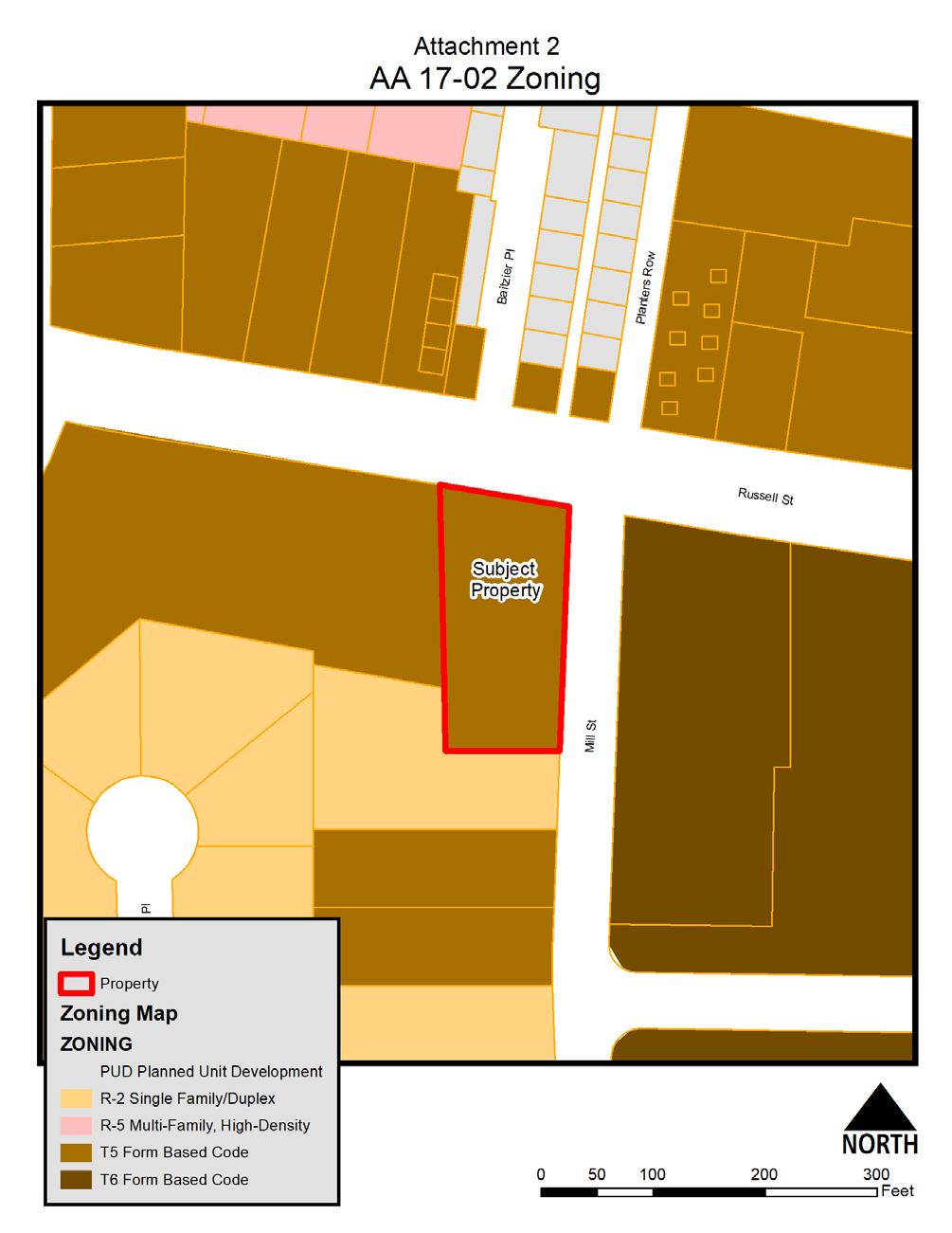
5 Saunders Ramsey came forward to speak in favor of the request. After discussion and upon the motion of Commissioner Dumas, duly seconded by Commissioner Gregory, the motion to approve PP was unanimously approved. After discussion and upon the motion of Commissioner Dumas, duly seconded by Commissioner Gregory, the motion to approve FP was unanimously approved with the following conditions: 1. The final plat shall meet the minimum standards for the State of Mississippi, as required by and of the Mississippi Code of 1972, as amended. 2. The final plat shall meet the minimum requirements for ZONE or DISTRICT dimensions. 3. All public utilities are currently in place as verified by the owner and engineer of record. 4. Erosion control vegetation shall be established on all disturbed areas. 5. Sidewalk construction shall conform to the City s Sidewalk Ordinance and ADA standards. 6. A bond or surety in the amount of 150% of the current cost of the proposed sidewalk and any other infrastructure improvements shall be provided prior to signing of the final plat. 7. The applicant shall provide two paper copies of the recorded plat to the City, along with a digital copy in AutoCAD format in standard state plane coordinates. 8. The final plat shall be recorded at the Office of the Oktibbeha County Chancery Clerk within thirty (30) days of the approval by the Mayor and Board of Aldermen. 9. Change the signature line of Mayor, City of Starkville, MS to reflect new mayor s name B. CONSIDERATION OF RZ REQUEST TO REZONE THREE LOTS LOCATED ON MILL STREET FROM R-2 TO T-5 WITH THE PARCEL NUMBERS 101D , 101D , AND 101D City Planner Daniel Havelin presented the request by William Reeves to rezone three lots located on Mill Street from R-2 to T-5 with the parcel numbers 101D , 101D , and 101D The property to the North is zoned T-5 and is currently a mixed-use project under construction. The property to the West is zoned R-2 and is currently Single-family. The property to the East is zoned T-6 and is currently Conference Center/Parking Garage. The property to the South is zoned T-4 and is currently a single-family home. 58 property owners of record within 300 feet of the subject property were notified directly by mail of the request. A public hearing notice was published in the Starkville Daily News on August 17, 2017 and a placard was posted on the property concurrent with publication of the notice. As of this date, the
6 Planning Office has received two phone calls inquiring about the request and one in favor of the request. A rezoning can only take place is one of the following conditions prevail Error: There is a Manifest Error in the ordinance and a Public Need to correct the There is No Error. Change in Condition: On January 12, 2012, the Board of Aldermen adopted Form Based Code for MS Highway 182, Main Street, University Drive, Lampkin Street, and Russell Street. As a result, 84 parcels were rezoned to either T District or Civic District. The subject parcel is adjacent to a T6 District parcel to the east On March 15, 2016, one parcel on Hartness Street was rezoned from R- 3 to T-5 On August 8, 2016, one parcel at the corner of University and North Montgomery was rezoned from C-2 to T-5. On January 1, 2017, one parcel at Jarnigan Street and was rezoned from R-5 to T-4. On April 4, 2017, one parcel at 114 Mill Street was rezoned from R-2 to T-4. The Commission Chair then opened up the public hearing and called for comments regarding the above request. Comments were received from the following individuals: William Reeves came forward to speak in favor of his request. Calling for and receiving no other comments, the Commission Chair closed the public hearing. After discussion and upon the motion of Commissioner Dumas, duly seconded by Commissioner Walker, the motion to approve RZ was unanimously approved. C. CONSIDERATION OF PP REQUEST FOR PRELIMINARY PLAT APPROVAL FOR COMBINING AND SUBDIVIDING SEVERAL LOTS. THE LOTS ARE LOCATED AT 104 AND 105 CAMP AVENUE AND 703, 703½, 705 AND 705½ UNIVERSITY DRIVE IN A T5 ZONING DISTRICT WITH THE PARCEL NUMBERS 101C , 101C , 101D , 101D , 101D , AND 101D City Planner Daniel Havelin presented the request by Walker Associates on behalf of Hal and Mary Ann Fuller, Betty Bell, and Harry Bell for Preliminary Plat approval for
7 combining and subdividing several lots into 4 lots. The proposed subdivision is named Veranda at the Cotton District. The proposed subdivision is located in a T5 zoning district. The existing lots in the proposed subdivision are located at 104 and 105 Camp Avenue and 703, 703½, 705 and 705½ University Drive. The subdivision has a gross acreage of +/ acres with a total of 4 lots. The proposed development has a gross density of 0.54 lots per acre. Lots 2, 3 and 4 are proposed to be Apartments and will be maintained by the developer. Lot 1 is designed as Residential (Flats) and will also include Commercial/Office space. A total of 312 residential units are being proposed by the developer acres of the proposed preliminary plat are shown as right-of-way for proposed public streets. Frank Summers came forward to speak in favor of the request. After discussion and upon the motion of Commissioner Dumas, duly seconded by Commissioner Walker, the motion to approve PP was unanimously approved. VIII. ADJOURN ADJOURN There came for consideration, the matter of the approval of the motion to adjourn until 5:30 p.m. on October 10, 2017, in the courtroom of City Hall located at 110 West Main Street, Starkville MS. After discussion, and upon the motion of Commissioner Dumas duly seconded by Commissioner Verdell, the motion to adjourn until 5:30 p.m. on October 10, 2017, in the courtroom of City Hall located at 110 West Main Street, Starkville MS, was unanimously approved. Mike Brooks, Commission Chair Daniel Havelin, City Planner
8
9 UNAPPROVED MINUTES OF THE SPECIAL CALL MEETING OF THE PLANNING AND ZONING COMMISSION CITY OF STARKVILLE, MISSISSIPPI NOVEMBER 01, 2017 Be it remembered, that, the members of the Planning and Zoning Commission of the City of Starkville, met at Special Call meeting on November 1, 2017 at 5:30 p.m. in the Courtroom of City Hall, located at 110 West Main Street, Starkville, MS. There being present were Michael Brooks, Chairman, Ward 4, Jim McReynolds, Ward 2, Tom Walker, Ward 3, Jeremiah Dumas, Ward 6, and Tommy Verdell Jr., Ward 7. Absent from the meeting was Jason Camp, Ward 1, and Alexis Gregory, Ward 5. Attending the Commissioners were City Planner Daniel Havelin, Assistant City Planner Emily Corban, Community Development Director Buddy Sanders, and City Attorney Chris Latimer, who joined the meeting by phone. Commission Chairman Michael Brooks opened the meeting with the Pledge of Allegiance followed by a moment of silence. CONSIDERATION OF THE OFFICIAL AGENDA There came for consideration, the matter of the approval of the motion to approve the Official Agenda of the Planning and Zoning Commission of November 01, 2017 as presented. OFFICIAL AGENDA PLANNING & ZONING COMMISSION CITY OF STARKVILLE, MISSISSIPPI MEETING OF TUESDAY, NOVEMBER 01, 2017 CITY HALL - COURT ROOM, 110 West Main Street, 5:30 PM I. CALL TO ORDER II. PLEDGE OF ALLEGIANCE AND MOMENT OF SILENCE III. ROLL CALL IV. CONSIDERATION OF THE OFFICIAL AGENDA V. CITIZEN COMMENTS VI. VIII. NEW BUSINESS A. FP REQUEST FOR FINAL PLAT APPROVAL FOR SUBDIVIDING +/ ACRE PARCEL INTO 16 LOTS. LOCATED AT THE EAST END OF TURNBERRY LANE AND CYPRESS POINT ROAD IN A R-4 ZONE WITH THE PARCEL NUMBER PLANNER S REPORT
10 IX. ADJOURN After discussion and upon the motion of Commissioner Walker duly seconded by Commissioner McReynolds, the motion to approve the official agenda of the Planning and Zoning Commission for November 1, 2017 received unanimous approval. CITIZEN COMMENTS The Chair opened up the meeting for Citizen Comments. Seeing there were none, the Commission moved to New Business. NEW BUSINESS A. CONSIDERATION OF FP REQUEST FOR FINAL PLAT APPROVAL FOR SUBDIVIDING +/ ACRE PARCEL INTO 16 LOTS. LOCATED AT THE EAST END OF TURNBERRY LANE AND CYPRESS POINT ROAD IN A R-4 ZONE WITH THE PARCEL NUMBER City Planner Daniel Havelin presented the request by Frank Jones Development for Final Plat approval for subdividing a +/ acre parcel into 16 lots. The proposed subdivision is named Country Club Estates Phase 3-B. The proposed subdivision is located in an R-4 Zone. The subdivision has a gross density of 1.46 units per acre. The stormwater drainage easement, repair, and/or replacement shall be the sole responsibility of the Owner s Association and not the City of Starkville. They City of Starkville disclaims any dedication, acceptance, interest, responsibility, and ownership of the stormwater drainage easement territory. The preliminary plat was approved by the Board of Alderman on September 17, A modified version of the preliminary plat was approved by the Board of Alderman on August 15, After discussion and upon the motion of Commissioner Dumas, duly seconded by Commissioner Walker, the motion to approve FP was unanimously approved with the following conditions: 1. The final plat shall meet the minimum standards for the State of Mississippi, as required by and of the Mississippi Code of 1972, as amended. 2. The final plat shall meet the minimum requirements for R-4 Zone dimensions. 3. All public utilities are currently in place and meet requirements as verified by the owner and engineer of record. 4. Prior to the execution of the Final Plat, erosion control shall be installed to the City s and MDEQ standards. 5. Sidewalk construction shall conform to the City s Sidewalk Ordinance and ADA standards. 6. The applicant shall provide adequate and satisfactory test reports for roadways, curbs and all drainage structures and facilities.
11 7. The covenants shall include provisions for the maintenance of common areas/stormwater management and the City Attorney s standard hold-harmless indemnification clause. 8. A bond or surety in the amount as determined by the City Engineer for infrastructure improvements shall be provided prior to approval by the Mayor and Board of Aldermen. 9. Financial assurance for the cost of the final layer of asphalt shall be determined by and provided to the City Engineer prior to approval by the Mayor and Board of Aldermen. 10. The roadways shall not be accepted by the City until at least 85% of all lots located on have been developed and received Certificates of Occupancy. The performance agreement shall remain in effect until such time. 11. The applicant shall execute the standard performance agreement ( developer contract ) for the financial guarantee of the completion of the final requirements for acceptance of the streets and infrastructure and the Board of Aldermen shall authorize the Mayor to execute same. 12. The applicant shall provide two paper copies of the recorded plat to the City, along with a digital copy in AutoCAD format in standard state plane coordinates. 13. The applicant shall provide as-built drawings of all infrastructure improvements (water, sewer, storm drainage, roadways, sidewalks, etc.) in AutoCAD format as well as a paper copy that is signed and sealed by a licensed design professional, guaranteeing accuracy. 14. The final plat shall be recorded at the Office of the Oktibbeha County Chancery Clerk within thirty (30) days of the approval by the Mayor and Board of Aldermen. 15. All required street signage shall be in place prior to the execution of the Final Plat. 16. Stormwater drainage easement maintenance, repair, and/or replacement shall be the sole responsibility of the Owners Association and not the City of Starkville. The City of Starkville disclaims any dedication, acceptance, interest, responsibility, and ownership of the stormwater drainage easement territory. 17. Add the following additional text to dedication section of the Final Plat, Stormwater drainage easement maintenance, repair, and/or replacement shall be the sole responsibility of the Owners Association and not the City of Starkville. The City of Starkville disclaims any dedication, acceptance, interest, responsibility, and ownership of the stormwater drainage easement territory. VIII. ADJOURN
12 ADJOURN The Commission adjourned until 5:30 p.m. on November 14, 2017, in the courtroom of City Hall located at 110 West Main Street, Starkville MS. Mike Brooks, Commission Chair Daniel Havelin, City Planner
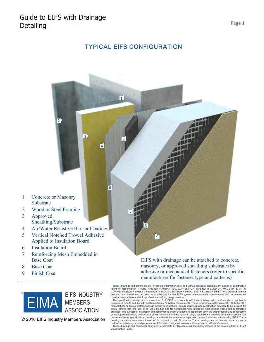
13 THE CITY OF STARKVILLE PLANNING DEPARTMENT PLANNING AND ZONING COMMISSION CITY HALL, 110 WEST MAIN STREET STARKVILLE, MISSISSIPPI STAFF REPORT To: Members of the Planning & Zoning Commission From: Daniel Havelin, City Planner ( ext. 3136) Emily Corban, Assistant City Planner ( ext. 3138) Subject: AA Request for an Administrative Appeal from denial of the use of EIFS for 550 Russell Street in a T-5 District with the parcel number 101D Date: November 14, 2017 The purpose of this report is to provide information regarding the request by Mark Castleberry of Castle Properties for an Administrative Appeal for 550 Russell Street in a T- 5 District with the property #101D Please see attachments 1-6. BACKGROUND INFORMATION: The applicant is appealing the decision by the Community Development Department to not allow the use of EIFS (exterior insulation and finish systems) on the 2 nd and 3 rd floor of a building currently under construction. The project is located in a T-5 District. The regulation of façade material can be found in the definition section of the T-District regulations under Façade. CODE SECTION DENIAL WAS BASED FROM: APPENDIX A ZONING, ARTICLE VII. DISTRICT REGULATIONS, Sec. T. Transect districts, 7. - DEFINITIONS. Façade the exterior wall of any building oriented toward or set along a Frontage Line. The following materials are allowed for use on a building façade: brick, wood, fiber cement siding, stucco and natural stone. (see Elevation) ADMINISTRATIVE APPEAL REQUIREMENTS: APPENDIX A ZONING, ARTICLE VII. DISTRICT REGULATIONS, Sec. T. Transect districts 1.4 ADMINISTRATIVE REVIEW (a) This Section specifically provides for the administrative approval or denial of site and/or building plans. (b) Administrative reviews of site and/or building plans shall be reviewed within 30 calendar days of receipt of a complete application submittal package to the Planning Office. (c) Any decision regarding an approval or denial of a site and/or building plan shall state, in writing, the reasons for the approval or denial, within 30 calendar days of receipt of the complete application submittal package to the Planning Office. (d) If the Planning Office denies any site and/or building plan, the applicant may appeal the decision to the Planning and Zoning Commission so long as the appeal is
14 submitted within 30 days of the denial. The Planning and Zoning Commission shall review the application de novo. i. The appeal must be filed with the Planning Office for submittal to the Planning and Zoning Commission. ii. The following procedures shall apply to all appeals: a. The appeal shall state specific relief sought and reasons for such relief. b. It shall be the applicant's responsibility to provide sufficient justification for approval of the appeal. c. The City Planner shall prepare a report evaluating the applicant's appeal for the Planning and Zoning Commission within 30 days of the filing of the appeal. If the Planning and Zoning Commission fails to act upon the appeal within 90 days of the filing of the appeal, the appeal will be deemed denied and subject to further appeal as set out in subsection (g). d. In reviewing the appeal, the Planning and Zoning Commission shall consider all technical evaluation and relevant factors presented by the applicant and City staff. e. The Planning and Zoning Commission may attach such conditions to the granting of the appeal as it deems necessary to further the purpose of this Form Based Code. f. If the appeal is approved, it shall be granted upon findings by the Planning and Zoning Commission that the following standards have been met: i. That failure to approve the appeal could result in exceptional hardship to the applicant; and ii. That approving the appeal will not result in any threats to public safety, extraordinary public expense, create nuisances, cause fraud or victimization of the public; and iii. That the necessity for the appeal is not the result of conditions which have been self-imposed by the applicant; and iv. That the approval of the appeal is the minimum necessary for the applicant to continue with the project. g. If the appeal is not approved, the decision of the Planning and Zoning Commission may be appealed to the Mayor and Board of Aldermen. The appeal shall be filed in writing by the applicant within 10 working days of the denial by the Planning and Zoning Commission and shall be filed with the Planning Office. The appeal shall be heard at the next regularly scheduled meeting of the Mayor and Board of Aldermen following receipt of the notice of appeal.

15
16

17 Attachment 3- Site Plan Graphic
18 Attachment 4- Letter of Appeal

19 Attachment 5- Applicant Statement
20

21 Attachment 6- Product Information from Applicant
22
23

24
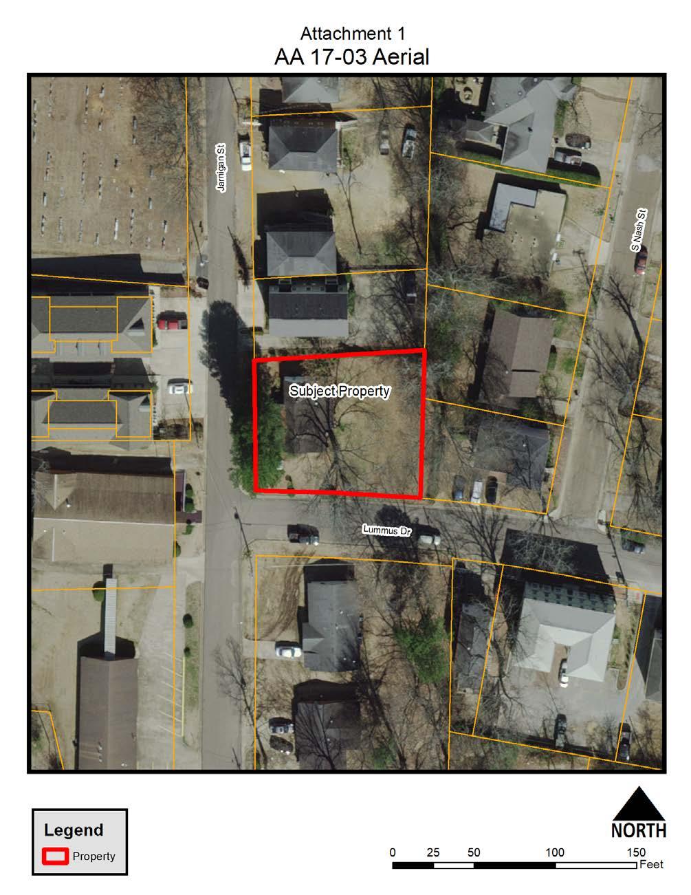
25 THE CITY OF STARKVILLE PLANNING DEPARTMENT PLANNING AND ZONING COMMISSION CITY HALL, 110 WEST MAIN STREET STARKVILLE, MISSISSIPPI STAFF REPORT To: Members of the Planning & Zoning Commission From: Daniel Havelin, City Planner ( ext. 3136) Emily Corban, Assistant City Planner ( ext. 3138) Subject: AA Request for an Administrative Appeal from denial of the placement of a secondary building at 35 Jarnigan Street in a T-4 District with the parcel number 101D Date: November 14, 2017 The purpose of this report is to provide information regarding the request by Dwight Harding for an Administrative Appeal for 35 Jarnigan Street in a T-4 District with the property #101D Please see attachments 1-4. BACKGROUND INFORMATION: The applicant is appealing the decision by the Community Development Department to not allow the placement of a secondary building on a lot that is less than 150 in depth. A lot less than 150 in depth can only have one primary and one outbuilding located on the lot. The Applicant is proposing to move an existing house from 104 Lummus and place it in the backyard of 35 Jarnigan Street which already has an existing house. CODE SECTION DENIAL WAS BASED FROM: APPENDIX A ZONING, ARTICLE VII. DISTRICT REGULATIONS, Sec. T. Transect districts, Specific to T4 Districts 6.2 Lot Occupation a) For Lots less than one-hundred and fifty (150) feet deep, one (1) Primary Building and one (1) Outbuilding may be built on each Lot Definitions. Primary Building: the main building on a Lot. Secondary Building: any ancillary building on a Lot. Outbuilding: A building usually located toward the rear of the same Lot as a Primary Building such as a garage, carport, or workshop and may include an Accessory Unit. 2 - General to all Transect Districts 2.4 Building Form e) The footprint of any Outbuilding shall not exceed 576 square feet.
26 ADMINISTRATIVE APPEAL REQUIREMENTS: APPENDIX A ZONING, ARTICLE VII. DISTRICT REGULATIONS, Sec. T. Transect districts 1.4 ADMINISTRATIVE REVIEW (a) This Section specifically provides for the administrative approval or denial of site and/or building plans. (b) Administrative reviews of site and/or building plans shall be reviewed within 30 calendar days of receipt of a complete application submittal package to the Planning Office. (c) Any decision regarding an approval or denial of a site and/or building plan shall state, in writing, the reasons for the approval or denial, within 30 calendar days of receipt of the complete application submittal package to the Planning Office. (d) If the Planning Office denies any site and/or building plan, the applicant may appeal the decision to the Planning and Zoning Commission so long as the appeal is submitted within 30 days of the denial. The Planning and Zoning Commission shall review the application de novo. i. The appeal must be filed with the Planning Office for submittal to the Planning and Zoning Commission. ii. The following procedures shall apply to all appeals: a. The appeal shall state specific relief sought and reasons for such relief. b. It shall be the applicant's responsibility to provide sufficient justification for approval of the appeal. c. The City Planner shall prepare a report evaluating the applicant's appeal for the Planning and Zoning Commission within 30 days of the filing of the appeal. If the Planning and Zoning Commission fails to act upon the appeal within 90 days of the filing of the appeal, the appeal will be deemed denied and subject to further appeal as set out in subsection (g). d. In reviewing the appeal, the Planning and Zoning Commission shall consider all technical evaluation and relevant factors presented by the applicant and City staff. e. The Planning and Zoning Commission may attach such conditions to the granting of the appeal as it deems necessary to further the purpose of this Form Based Code. f. If the appeal is approved, it shall be granted upon findings by the Planning and Zoning Commission that the following standards have been met: i. That failure to approve the appeal could result in exceptional hardship to the applicant; and ii. That approving the appeal will not result in any threats to public safety, extraordinary public expense, create nuisances, cause fraud or victimization of the public; and
27 iii. That the necessity for the appeal is not the result of conditions which have been self-imposed by the applicant; and iv. That the approval of the appeal is the minimum necessary for the applicant to continue with the project. g. If the appeal is not approved, the decision of the Planning and Zoning Commission may be appealed to the Mayor and Board of Aldermen. The appeal shall be filed in writing by the applicant within 10 working days of the denial by the Planning and Zoning Commission and shall be filed with the Planning Office. The appeal shall be heard at the next regularly scheduled meeting of the Mayor and Board of Aldermen following receipt of the notice of appeal.
28

29
30 Attachment 3- Site Plan
31 Attachment 4- Letter of Appeal
32
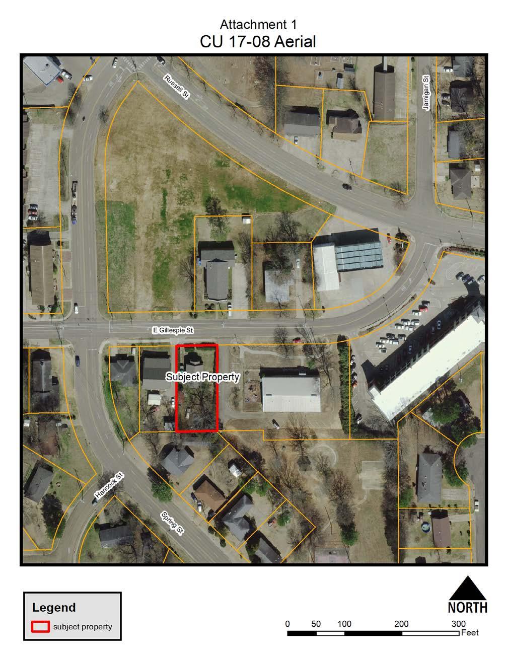
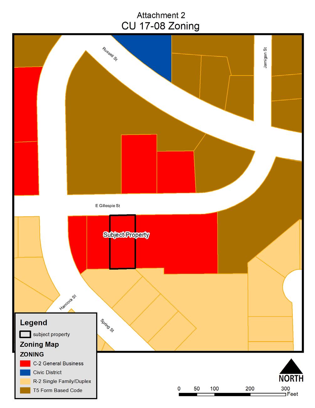
33 The purpose of this report is to provide information regarding the Conditional Use Request by First Church of Christ to allow for a parking lot to be located at 609 Gillespie Street in an C-2 zone with the property #101D Please see attachments 1-4. BACKGROUND INFORMATION The applicant is seeking a Conditional Use to construct a parking lot to be used for church parking. The property is zoned C-2 and in order to construct a Parking Lots & Garages, a Conditional Use is required per the City of Starkville s Permitted and Conditional Use Chart. Scale and intensity of use. The applicant has provided a conceptual site plan which seems to meet the City s land development requirements and is proportionate to the area. On- or off-site improvement needs. Sidewalks will be required in the right of way. A complete site plan review will be conducted by the Development Review Committee to insure compliance with land development regulations prior to issuing of permits. On-site amenities proposed to enhance the site. There are no amenities being proposed THE CITY OF STARKVILLE PLANNING DEPARTMENT PLANNING AND ZONING COMMISSION CITY HALL, 110 WEST MAIN STREET STARKVILLE, MISSISSIPPI STAFF REPORT To: Members of the Planning & Zoning Commission From: Daniel Havelin, City Planner ( ext. 3136) Emily Corban, Assistant City Planner ( ext. 3138) Subject: CU Request for Conditional Use to allow for a parking lot at 609 Gillespie Street in an C-2 zone with the parcel number 101D Date: Site issues. There are no known site issues regarding the intended use of the site The table below provides the zoning and land uses adjacent to the subject property: Direction Zoning Current Use North T-5/C-2 Apartments/church East C-2 Park Community Center South R-2 Single-Family Home West C-2 Single-Family Home ALLOWED USES UNDER THE PERMITTED (PU) AND CONDITIONAL USE(CU) CHART The following uses are permitted by right in the C-2 zoning district: 1. Accessory dwelling unit 2. Assisted Living Facility 3. Bed & Breakfast Inn 4. Boarding/Rooming House
34 5. Dormitory 6. Personal Care/Group Home 7. Child Care 8. Government Facilities 9. Institutional and Heath Care Facilities 10. Parks & Recreation, Active 11. Parks & Recreation, Passive 12. Public Spaces 13. Transportation 14. Utilities 15. Business Offices 16. Conference/Convention Center 17. Eating & Drinking Establishments 18. Funeral Home 19. General Retail & Services 20. Personal Services 21. Recreation and Entertainment, Indoor 22. Vehicular Sales & Service 23. Visitor Accommodations & Services 24. Trades & Skilled Services 25. Warehousing & Distribution 26. Wholesale Services The following uses are allowed by conditional use in the C-2 zoning district: 1. Dwelling, live/work 2. Dwelling, single family, detached 3. Dwelling, multi-family 4. Dwelling, 3 & 4-family 5. Dwelling, 2-family 6. Fraternity/Sorority House 7. Manufactured Home 8. Community Services 9. Education Facilities 10. Places of Worship 11. Wireless Communication Towers 12. Car Title Loan, Payday Advance or Loan Business 13. Parking Lots & Garages 14. Recreation and Entertainment, Outdoor 15. Manufacturing, light 16. Farm Support NOTIFICATION 21 property owners of record within 300 feet of the subject property were notified directly by mail of the request. A public hearing notice was published in the Starkville Daily News on Monday October 30, 2017 and a placard was posted on the property. As of this date, the Planning Office has received one is support of this request.
35 ANALYSIS Appendix A, Article VI, Section I of the City s Code of Ordinances provides five specific criteria for conditional use review and approval: 1. Land use compatibility. The proposed use as a Parking Lots & Garages could be considered a compatible use with adjacent properties. The proposed parking lot is located across the street from the existing church. The property is currently zoned C-2. The 2016 Comprehensive plan has the areas placetype listed as urban corridor. 2. Sufficient site size and adequate site specifications to accommodate the proposed use. The site is adequately sized to accommodate the proposed use. 3. Proper use of mitigative techniques. None proposed 4. Hazardous waste. No hazardous waste or materials would be generated, used or stored at the site 5. Compliance with applicable laws and ordinances. The applicant is responsible for obtaining all the property permitting required by City. Requested Conditions: 1. The applicant shall have six months from time of Conditional Use approval to obtain site plan approval by the City s Development Review Committee.
36
37
38 Attachment 3 Proposed Parking lot
39 Attachment 4- in support of the request
40
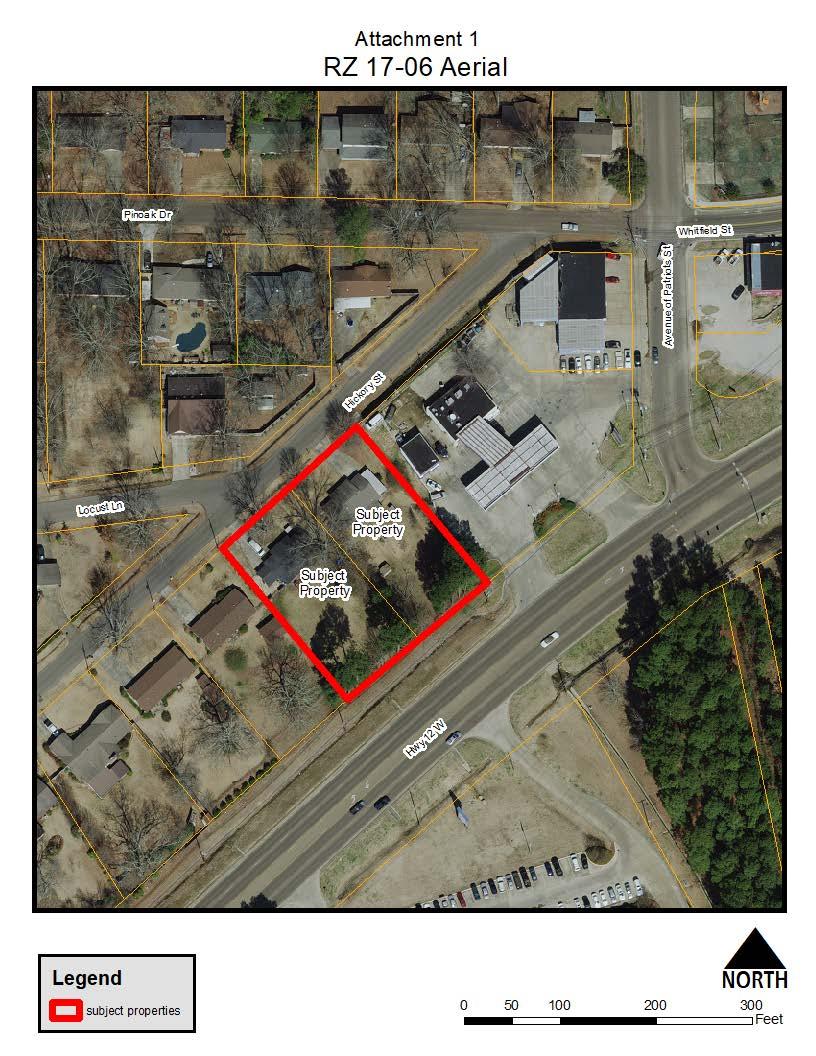
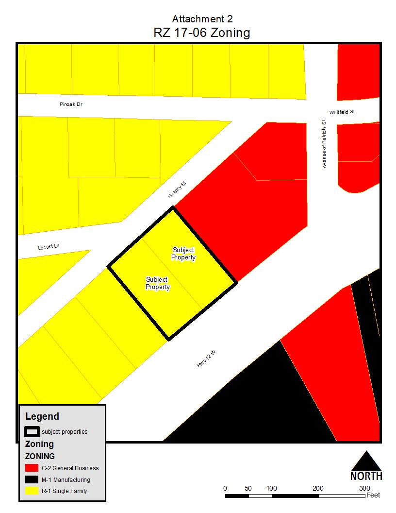
41 THE CITY OF STARKVILLE PLANNING DEPARTMENT PLANNING AND ZONING COMMISSION CITY HALL, 110 WEST MAIN STREET STARKVILLE, MISSISSIPPI STAFF REPORT To: Members of the Planning & Zoning Commission From: Daniel Havelin, City Planner ( ext. 3136) Emily Corban, Assistant City Planner ( ext. 3138) Subject: RZ Request to Rezone 2 lots located at 2003 and 2005 Hickory Street from R-1 to C-2 with the parcel numbers 102F and 102F Date: November 14, 2017 The purpose of this report is to provide information regarding the request by Mitchener Rentals, LLC and Danielle V. Kelly to rezone 2 lots located at 2003 and 2005 Hickory Street from R-1 Single Family to C-2 General Business with the property #102F and 102F Please see attachments 1-7. BACKGROUND INFORMATION: The applicant is seeking to rezone from R-1 Single Family to C-2 General Business based on changed or changing conditions in the existing area, or in the planning area generally, that make the change in the ordinance necessary & desirable, & in accord with the public need for orderly & harmonious growth. Development plans for the property are unknown to City Staff at this time. The applicant previously was set to appear before the Planning and Zoning Commission on August 8, The applicant requested that the item be removed from consideration at that scheduled public hearing. Zoning Change Subject Property Properties 1960s Current 2000 Map 1970s Map Map Map 102F F R-1 R-1 R-1 R-1 Zoning Change Adjacent Properties Properties 1960s Current 2000 Map 1970s Map Map Map North R-1 R-1 R-1 R-1 East M-1 C-2 C-2 C-2 South M-1 M-1 M-1 M-1 West R-1 R-1 R-1 R-1 Zoning and land uses adjacent to the subject property Direction Zoning Current Use North R-1 Single Family Residence C Store and Vehicular C-2 East Service South M Business Center West R-1 Single Family Residence
42 NOTIFICATION: 30 property owners of record within 300 feet of the subject property were notified directly by mail of the request. A public hearing notice was published in the Starkville Daily News October 5, 2017 and a placard was posted on the property 15 or more days prior to the hearing. As of this date, the Planning Office has received six phone calls, two in office visits, and five letters against the request. The Planning Office has also received 2 phone calls inquiring about the request. The Planning Office has received one letter in support of the request. This includes all correspondence from the previous submittal. REZONING REQUEST: The subject property rezoning request is from R-1 Single Family to C-2 General Business. The Differences between zones are: Current Zoning District: Sec. C. - R-1 residence zoning district regulations. These [R-1 residential] districts are intended to be composed mainly of single-family residential properties along with appropriate neighborhood facilities, with their character protected by requiring certain minimum yard and area standards to be met. [The following regulations apply to R-1 districts:] 1. See chart for permitted uses. 2. See chart for uses which may be permitted as a special exception. 3. Required lot area and width, yards, building areas and height for residences: a) Minimum lot area: 10,000 square feet. b) Minimum lot width at the building line: 75 feet. c) Minimum depth of front yard: 30 feet. d) Minimum depth of rear yard: 35 feet. e) Minimum width of each side yard: Ten feet. f) Maximum height of structure: 45 feet. 4. Off-street parking requirements: See article VIII of this ordinance for requirements for other uses. Proposed Zoning District: Sec. L. - C-2 business (general business) zoning district regulations. These [C-2 general business] districts are intended to be composed of the wide range of commercial goods and services to support community needs. Under special conditions some light industrial and distribution uses are also permitted. Usually located along arterial streets or near the intersection of two or more arterials, these districts are usually large and within convenient driving distance of the entire community. The district regulations provide for certain minimum yard and area standards to be met to assure adequate open space and compatibility with surrounding districts. [The following regulations apply in the C-2 districts:]
43 1. See chart for uses permitted. 2. See chart for uses which may be permitted as an exception. 3. Minimum lot size: It is the intent of this ordinance that lots of sufficient size be used for any business or service use and to provide adequate parking and loading space in addition to the space required for the other normal operations of the business or service. 4. Minimum yard size: Front, 20 feet; rear, 20 feet; side, a total of 20 feet, but one side shall be sufficient in width to provide vehicular access to the rear. On any lot [in] which the side lot line adjoins a residential district, the side yard on that side shall not be less than required by the residential district. 5. Maximum height of building or structures: 45 feet. 6. Off-street parking: One space for each 200 square feet of retail or office building area. See article VIII of this ordinance for requirements for other uses. 7. Off-street loading and unloading: The required rear or side yard may be used for loading and unloading. 8. All building facades that are visible from public right-of-way or adjacent property zoned residential shall meet these requirements. a) The following materials are allowed for use on a building façade: brick, wood, fiber cement siding, stucco, natural stone, and split faced concrete masonry units that are tinted and textured. Architectural metal panels may be used as long as the panels make up less than 40 percent of an individual façade. b) The following materials are not allowed for use on a building facade: smooth faced concrete masonry units, vinyl siding, tilt-up concrete panels, non-architectural steel panels (R Panels), and EIFS (exterior insulation and finish systems). EIFS is permitted to be used for trim and architectural accents. c) The primary facade colors shall be low reflectance, subtle, neutral or earth tones. The use of high intensity, metallic flake, or fluorescent colors is prohibited. d) All parking lots adjacent to public right-of-way shall be paved either entirely or with a combination of the following: asphalt, concrete, porous pavement, concrete pavers, or brick pavers. Gravel can be used temporarily as a parking surface for a period on no longer than 12 months upon the approval of the community development director. All temporary gravel lots must provide ADA accessible parking and access ways in accordance with the ADA guidelines. (Ord. No , )
44 Permitted and Conditional Uses: The following uses are permitted by right in the C-2 zoning district: 1. Accessory dwelling unit 2. Assisted Living Facility 3. Bed & Breakfast Inn 4. Boarding/Rooming House 5. Dormitory 6. Personal Care/Group Home 7. Child Care 8. Government Facilities 9. Institutional and Heath Care Facilities 10. Parks & Recreation, Active 11. Parks & Recreation, Passive 12. Public Spaces 13. Transportation 14. Utilities 15. Business Offices 16. Conference/Convention Center 17. Eating & Drinking Establishments 18. Funeral Home 19. General Retail & Services 20. Personal Services 21. Recreation and Entertainment, Indoor 22. Vehicular Sales & Service 23. Visitor Accommodations & Services 24. Trades & Skilled Services 25. Warehousing & Distribution 26. Wholesale Services The following uses are allowed by conditional use in the C-2 zoning district: 1. Dwelling, live/work 2. Dwelling, single family, detached 3. Dwelling, multi-family 4. Dwelling, 3 & 4-family 5. Dwelling, 2-family 6. Fraternity/Sorority House 7. Manufactured Home 8. Community Services 9. Education Facilities 10. Places of Worship 11. Wireless Communication Towers 12. Car Title Loan, Payday Advance or Loan Business 13. Parking Lots & Garages 14. Recreation and Entertainment, Outdoor 15. Manufacturing, light 16. Farm Support
45 STATE REZONING CRITERIA Per Title 17, Chapter 1, of the Mississippi Code of 1972, as amended, and Appendix A, Article IV, Section A, of the City of Starkville Code of Ordinances, the Official Zoning Map may be amended only when one or more of the following conditions prevail: 1. Error: There is a Manifest Error in the ordinance and a Public Need to correct the error: No Error 2. Change in conditions: Changed or changing conditions in an existing area, or in the planning area generally, or the increased or increasing need for commercial or manufacturing sites or additional subdivision of open land into urban building sites make a change in the ordinance necessary and desirable, and in accord with the public need for orderly and harmonious growth. New or Expanded commercial developments west of Louisville Street along Highway 12 (unless noted dates shown are for site plan approval not opening date) AT&T Retail Store Cellular South Tractor Supply Barnes Crossing Auto Sales Dollar Tree Kroger- Expanded in 2014 Panda Express Academy Sports- Opened in 2017 Consistency with Comprehensive Plan: The proposed rezoning would generally be not consistent with the goals, objectives and policies found in the City s Comprehensive Plan. The property s place type is shown as Suburban Single Family. Land Use Compatibility: The proposed rezoning would be compatible with property to the east, but not compatible with property to the west and north.
46
47
48 Attachment 3- Letters Against the Request
49
50
51
52
53 Attachment 4- Letter for the request
54

55 Attachment 5
56 Attachment 6 Attachment 7
57 THE CITY OF STARKVILLE PLANNING DEPARTMENT PLANNING AND ZONING COMMISSION CITY HALL, 110 WEST MAIN STREET STARKVILLE, MISSISSIPPI STAFF REPORT To: Members of the Planning & Zoning Commission From: Daniel Havelin, City Planner ( ext. 3136) Emily Corban, Assistant City Planner ( ext. 3138) Subject: Proposed Sign Ordinance Amendment Date: November 14, 2017 The purpose of this report is to provide information for proposed amendments to Appendix A- Zoning, Article IX- Signage. SUMMARY OF PROPOSED ORDINANCE AMENDMENTS: 1. Modifying the physical size of banners for approved special event advertising on Main Street. The current requirements limit the size of all banners to 24 square feet. The proposed change increases the size to a maximum of 90 square feet with specific requirements for managing wind load and the location of eyelets for mounting the banner. 2. Removal and Replacement of current Billboard requirements. All existing billboards will be declared legal non-conforming billboards. Existing billboards will be placed into two types (I and II) categories. Type I are billboards that are subject to the requirements of state law. Type II are billboards that are not subject to the requirements of state law. 3. Removal of billboards from the amortization clause that governs all other sign types within the City. The removal schedule of Type II billboards is located in the proposed Section J (E) 4. Removal and Replacement of references to the Administrative Adjudication Process and Administrative Hearing Officer. 5. Modifying the variance process for signs. Dimensional variances will be heard by the Board of Adjustment and Appeals. All other variances will be heard by the Planning and Zoning Commission. Final approval and appeals will be heard by the Board of Aldermen. NOTIFICATION: A public hearing notice was published in the Starkville Daily News October 3, As of this date, the Planning Office has received no phone calls against the request. The Board of Aldermen will hold the first public hearing on the proposed amendments on November 21, 2017 and a second public hearing on the proposed amendments on December 5, PROPOSED ORDINANCE AMENDMENT: See Attachment 1
58 Attachment 1
59 ARTICLE IX. - SIGNAGE Sec. A. - Purpose and intent. The regulations and requirements herein set forth shall be the minimum requirements to promote the health, safety and general welfare of the public and to protect the character of the City of Starkville. The purpose and intent of these regulations is to create the legal frame work for a comprehensive and balanced system of signage to improve and enhance the aesthetic environment of the city and to avoid the visual clutter that is potentially harmful to traffic and to the appearance of the community. The Mayor and Board of Aldermen of the City of Starkville find that the regulations set forth herein will improve the visual appearance of the city by limiting the number and size of signs within the corporate limits, consistent with constitutional guarantees, while continuing to provide an effective means of communication. (Ord. No , 1, ) Sec. B. - General. For words, terms and phrases used in this article that are not defined in section C, below, or elsewhere in the City's Code of Ordinances, the city planner shall have the authority and power to interpret or define such words, terms and phrases. In making such interpretations or definitions, the city planner may consult secondary sources related to the planning and legal professions, such as "Black's Law Dictionary" (West Publishing Company, St. Paul, Minn., most current edition), "The Latest Illustrated Book of Development Definitions" by Harvey S. Moskowitz and Carl G. Lindbloom (Center for Urban Policy Research, Rutgers University. N.J. 2007, or most current edition), for technical words, terms, phrases and graphics, or any "Webster's Dictionary" for other words, terms and phrases. (Ord. No , 2, ) Sec. C. - Definitions. Amortization means a method of eliminating nonconforming uses by requiring the termination of the nonconforming use after a specified period of time. Animated sign means any sign or part of a sign that changes physical position or flashes, moves, or otherwise changes at intervals of no less than once every ten seconds. Awning sign means any sign attached to, in any manner, or otherwise made a part of any awning or awninglike structure which projects beyond a building or extends along and projects beyond the wall of the building, generally designed and constructed to provide protection from the weather; sometimes referred to as a "canopy sign". Balloon means a bag inflated with a gas, such as helium, that causes it to rise and float in the atmosphere, intended to be used for advertising or as an attention-getting device. Banner means a display, informational sign or other advertising device constructed of cloth, canvas, fabric, wood, foam-core or fiber-board, or other temporary material, with or without a structural frame, and intended for a limited period of display and used to advertise an event, product, business or service. Bench sign means a sign located on any part of the surface of a bench or seat placed on or adjacent to a public right-of-way. Bypass sign means a sign located along a federal or state highway where the posted speed limit is at least 55 mph, to assist the travelling public. These types of signs shall be ground signs supported totally by a solid base of masonry, brick, or other material, which base is not less than 80 percent of the total sign area width and which is of a finished or decorative type construction. Any metal or nonmasonry Page 1
60 structural components of the sign shall be painted a flat or matte color to blend aesthetically with other outdoor fixtures and furnishings. The area beneath and around the sign shall be landscaped with plants, ground cover and materials so as to complement the site and integrate the monument sign with buildings, parking areas, surrounding vegetation and natural features of the landscape. Bypass signs are only allowed by right in C-2 zoning districts. Construction site identification sign means a temporary sign erected on the site or premises where construction is taking place during the period of such construction, indicating the names of the design professionals, general contractor, subcontractors, suppliers, owners, sponsors, supporters, financiers, and similar individuals and groups having a role or interest with respect to the structure or project. Copy area means the area of space on any face of the sign to be used for advertising purposes, including the spaces between open-type letter and figures, including the background structure, or other decoration or addition which is an integral part of the sign. Sign supports shall be excluded in determining the area of a sign. The largest face of a multi-faced sign shall be used in calculating the area of a sign to determine compliance with this article. The area of a wall sign shall be measured within a single, continuous perimeter of any straight-line geometric figure which encloses the extreme limits of the advertising message. Curved, spherical, or any other shaped sign shall be computed on the basis of actual surface area. The copy area of signs composed of individual letters, numerals, or other devices shall be the sum of the area of the smallest rectangle or other geometric figures encompassing each said letter or devices. The calculation for a double-faced sign shall be so constructed that the perimeter of both faces coincides and are parallel and not more than 24 inches apart. Discontinued sign means any sign which no longer identifies an activity conducted or present on the premises where the sign is located. Directional sign means any sign of a noncommercial nature which directs the reader to the location of public institutions, historical areas, emergency shelters, public parks, public buildings, organizations identified by Section 26 U.S.C. 501(c)(3) of the United States Internal Revenue Code. Directional signs are permitted in all zoning districts and in no instance will a directional sign be allowed to be placed in the public right-of-way. Electronic message board sign means any sign that uses changing light to form a sign message wherein the sequence of message and the rate of change is electronically programmed and can be modified by electronic processes. Electric message boards shall change no less than once every ten seconds. Flag means any fabric or flexible material attached to or designed to be flown from a flagpole or other similar structure. No more than three flags of a national, state, religious, educational, fraternal or civic organization shall be displayed. Flashing sign means any sign, which, by method or manner of illumination, flashes on or off or winks or blinks with varying light intensity, shows motion, or creates the illusion of motion or revolves in a manner to create the illusion of being on or off. Flashing signs shall not be confused with electronic message boards. Flashing signs are not permitted in any zoning district. Illuminated sign means a sign illuminated in any manner by an artificial light source such as a spotlight or internally through a translucent background. Transparent backgrounds or surfaces are not allowed to be used in the construction of an illuminated sign. A neon tube shall be classified as an illuminated sign if it is nonchanging and nonflashing. Inflatable display means any display used for advertising or attention-getting purposes, whether a specific advertising message is used or not, that is held in a rigid or semi-rigid state by a pressurized gas such as air or nitrogen, etc. Inflatable displays are prohibited by this article, except for holiday decorations in residentially-zoned areas. Kiosk means a freestanding structure upon which temporary information and/or posters, notices and announcements are posted. A kiosk may incorporate a public pay phone, a trash receptacle and may include a small electronic message board sign. Its design should reflect the character of the surrounding area. Kiosks are allowed in all commercial and PUD zoning districts. Page 2
A. CONSIDERATION OF THE UNAPPROVED MINUTES OF DECEMBER 11, 2018
 I. CALL TO ORDER OFFICIAL AGENDA PLANNING & ZONING COMMISSION CITY OF STARKVILLE, MISSISSIPPI MEETING OF TUESDAY, JANUARY 8, 2018 1ST FLOOR CITY HALL COURT ROOM 110 WEST MAIN STREET AT 5:30 PM II. III.
A. CONSIDERATION OF THE UNAPPROVED MINUTES OF NOVEMBER 13, 2018
 I. CALL TO ORDER OFFICIAL AGENDA PLANNING & ZONING COMMISSION CITY OF STARKVILLE, MISSISSIPPI MEETING OF TUESDAY, DECEMBER 11, 2018 1ST FLOOR CITY HALL COURT ROOM 110 WEST MAIN STREET AT 5:30 PM II. III.
A. Consideration of the unapproved December 8, 2015 minutes B. Consideration of the unapproved January 12, 2016 minutes
 OFFICIAL AGENDA PLANNING & ZONING COMMISSION CITY OF STARKVILLE, MISSISSIPPI MEETING OF TUESDAY, April 12, 2016 CITY HALL - COURT ROOM, 110 West Main Street, 5:30 PM I. CALL TO ORDER II. III. IV. PLEDGE
ORDINANCE NUMBER
 ORDINANCE NUMBER 2011-02 AN ORDINANCE REPEALING AND REPLACING ORDINANCE NUMBER 2008-10, REGULATING THE CONSTRUCTION AND AESTHETIC IMPACT OF SIGNS WITHIN THE CORPORATE LIMITS OF THE CITY OF STARKVILLE,
City of Jasper Sign Ordinance
 City of Jasper Sign Ordinance DIVISION 4. SIGNS Sec. 230 Permits Required (a) A sign permit shall be obtained from the Sign Administrator prior to the erection or placement of a sign, except those signs
1. Animated: A sign or part of a sign that moves or appears to move.
 ZONING ORDINANCE, ARTICLE 16, SIGNS PAGE 16:1 ARTICLE 16 SIGNS 3-360 Purpose and Intent The purpose of this article is to promote and protect the public health, safety, and welfare by regulating outdoor
Zoning Ordinance Chapter 9
 CHAPTER 9 SIGNAGE SECTION 9.0 PURPOSE A. The purpose of this Ordinance is to establish comprehensive provisions that will eliminate confusing, distracting and unsafe signs located on private property;
TITLE NINE - SUPPLEMENTAL REGULATIONS Chapter Signs. CHAPTER 1179 Signs. (1) Promote attractive and high value residential districts.
 Promote attractive and high value residential districts.") Village of Boston Heights OH, Planning and Zoning Code, Sign Regulations 1 TITLE NINE - SUPPLEMENTAL REGULATIONS Chapter 1179. Signs. CHAPTER 1179 Signs 1179.01 Purposes 1179.02 Definitions 1179.03 General
Village of Boston Heights OH, Planning and Zoning Code, Sign Regulations 1 TITLE NINE - SUPPLEMENTAL REGULATIONS Chapter 1179. Signs. CHAPTER 1179 Signs 1179.01 Purposes 1179.02 Definitions 1179.03 General
ARTICLE 9: Sign Standards
 ARTICLE 9: Sign Standards... 9-1 17.9.1: General...9-1 17.9.1.1: Purpose and Intent... 9-1 17.9.1.2: Applicability... 9-1 17.9.1.3: Severability... 9-1 17.9.1.4: Prohibited Signs... 9-2 17.9.2: Types of
Article 18. Sign Regulations
 Article 18. Sign Regulations Section 18.01 Purpose and Intent Section 18.02 Use Regulations Section 18.03 Classification of Signs Section 18.04 Structural Types Section 18.05 General Standards Section
SIGNS MASTER SIGN PROGRAM
 SIGNS MASTER SIGN PROGRAM How to apply for a Master Sign Program What is the purpose of a Master Sign Program? A Master Sign Program (MSP) is used to create standard sign design guidelines for projects
Article 9 Signs and Billboards
 Article 9 Signs and Billboards Section 9.01 Intent and Purpose The intent of this article is to regulate the type, number, physical dimensions, erection and placement of signs in Arbela Township. The purpose
No sign shall interfere with vehicular or pedestrian safety in any manner.
 Chapter 1170 Signs 1170.01 PURPOSE AND INTENT The purpose of these sign regulations is to encourage the proper development and use of signage and to permit and regulate signs in such a way as to support
Sign, Canopy: A sign attached to the underside of a canopy.
 SECTION 15 SIGNS 15.1 Purpose: The requirements established herein are designed to regulate sign structures in order to insure light, air, and open space; to reduce hazards at intersections; to prevent
Excerpt from Town of West Greenwich, RI Zoning Ordinance Amended by Town Council September 12, 2007, and September 10, 2008
 ARTICLE IV SIGN REGULATIONS Section 1. Purpose and intent. The purpose of this Article is to: A. Improve pedestrian and traffic safety; B. Encourage the effective use of signs as a means of communication
PLANNING COMMISSION Thursday, September 5, :00 p.m. Council Chambers, Administration Building 100 Ribaut Road, Beaufort, South Carolina
 PLANNING COMMISSION Thursday, September 5, 2013 6:00 p.m. Council Chambers, Administration Building 100 Ribaut Road, Beaufort, South Carolina In accordance with South Carolina Code of Laws, 1976, Section
CHAPTER 154: SIGNS. Section
 CHAPTER 154: SIGNS Section 154.01 Permit required 154.02 Where prohibited 154.03 Street decorations 154.04 Approval by state 154.05 Purpose 154.06 Definitions 154.07 General sign and street graphics regulations
OFFICIAL AGENDA PLANNING & ZONING COMMISSION CITY OF STARKVILLE, MISSISSIPPI
 OFFICIAL AGENDA PLANNING & ZONING COMMISSION CITY OF STARKVILLE, MISSISSIPPI MEETING OF TUESDAY, JANUARY 14, 2013 CITY HALL - COURT ROOM, 101 E. LAMPKIN STREET, 5:30 PM I. CALL TO ORDER II. III. IV. PLEDGE
CHAPTER 7. SIGNS TABLE OF CONTENTS ARTICLE 1. GENERAL Sec INTENT Sec NUMBER OF SIGNS AND SURFACE AREA...
 CHAPTER 7. SIGNS TABLE OF CONTENTS ARTICLE 1. GENERAL... 2 Sec. 7.1.1. INTENT.... 2 Sec. 7.1.2. NUMBER OF SIGNS AND SURFACE AREA.... 2 Sec. 7.1.3. DEFINITIONS.... 4 ARTICLE 2. REQUIREMENTS... 8 Sec. 7.2.1.
CHAPTER 26 PLANNING AND ZONING ARTICLE VII. MOBILE HOMES AND RECREATIONAL VEHICLE (RV) PARKS. Recreational Vehicle (RV) Park Development Standards
 PARKS. Recreational Vehicle (RV) Park Development Standards") CHAPTER 26 PLANNING AND ZONING ARTICLE VII. MOBILE HOMES AND RECREATIONAL VEHICLE (RV) PARKS. Section 26-VII-1. Section 26-VII-2. Section 26-VII-3. Section 26-VII-4. Section 26-VII-5. Purpose Permitted
CHAPTER 26 PLANNING AND ZONING ARTICLE VII. MOBILE HOMES AND RECREATIONAL VEHICLE (RV) PARKS. Section 26-VII-1. Section 26-VII-2. Section 26-VII-3. Section 26-VII-4. Section 26-VII-5. Purpose Permitted
ARTICLE XII SIGNAGE REGULATIONS
 ARTICLE XII Section 1. Section 2. Section 3. Section 4. Section 5. PURPOSE OF SIGNAGE REGULATIONS SIGN DEFINITIONS GENERAL SIGN STANDARDS SIGN STANDARDS BY TYPE PERMANENT SIGN STANDARDS Section 6. PROHIBITED
MEMORANDUM. DATE: August 31, Honorable Mayor and City Councilmembers Patrick Klaers, City Administrator. Matthew Bachler, Associate Planner
 NEW BUSINESS 8B MEMORANDUM DATE: August 31, 2015 TO: FROM: Honorable Mayor and City Councilmembers Patrick Klaers, City Administrator Matthew Bachler, Associate Planner SUBJECT: Planning Case #15-016 Applicant:
ARTICLE 14 PLANNED UNIT DEVELOPMENT (PUD) DISTRICT
 DISTRICT") ARTICLE 14 PLANNED UNIT DEVELOPMENT (PUD) DISTRICT Section 14.01 Intent. It is the intent of this Article to allow the use of the planned unit development (PUD) process, as authorized by the Michigan Zoning
ARTICLE 14 PLANNED UNIT DEVELOPMENT (PUD) DISTRICT Section 14.01 Intent. It is the intent of this Article to allow the use of the planned unit development (PUD) process, as authorized by the Michigan Zoning
Section XXIV Signs (including Banners, Flags, and Temporary Signs)
") Section XXIV Signs (including Banners, Flags, and Temporary Signs) A. Guiding Principle Allow for adequate information to be conveyed without compromising the rural character of Rochester. B. Specific
Section XXIV Signs (including Banners, Flags, and Temporary Signs) A. Guiding Principle Allow for adequate information to be conveyed without compromising the rural character of Rochester. B. Specific
UPPER MOUNT BETHEL TOWNSHIP NORTHAMPTON COUNTY, PENNSYLVANIA
 UPPER MOUNT BETHEL TOWNSHIP NORTHAMPTON COUNTY, PENNSYLVANIA JOINDER DEED / LOT CONSOLIDATION TOWNSHIP REVIEW PROCESS When accepting proposed Joinder Deeds / Lot Consolidations, review the Joinder Deed
TITLE XV: LAND USAGE 150.BUILDING REGULATIONS 151.FLOOD DAMAGE PREVENTION 153.[RESERVED] 154.COMPREHENSIVE PLAN 155.SUBDIVISION AND ZONING CODE
![TITLE XV: LAND USAGE 150.BUILDING REGULATIONS 151.FLOOD DAMAGE PREVENTION 153.[RESERVED] 154.COMPREHENSIVE PLAN 155.SUBDIVISION AND ZONING CODE](/thumbs/86/94109177.jpg "TITLE XV: LAND USAGE 150.BUILDING REGULATIONS 151.FLOOD DAMAGE PREVENTION 153.[RESERVED] 154.COMPREHENSIVE PLAN 155.SUBDIVISION AND ZONING CODE") 1 TITLE XV: LAND USAGE Chapter 150.BUILDING REGULATIONS 151.FLOOD DAMAGE PREVENTION 152.SIGN AND BILLBOARD REGULATIONS 153.[RESERVED] 154.COMPREHENSIVE PLAN 155.SUBDIVISION AND ZONING CODE 2006 S-2 1 2
1 TITLE XV: LAND USAGE Chapter 150.BUILDING REGULATIONS 151.FLOOD DAMAGE PREVENTION 152.SIGN AND BILLBOARD REGULATIONS 153.[RESERVED] 154.COMPREHENSIVE PLAN 155.SUBDIVISION AND ZONING CODE 2006 S-2 1 2
CHAPTER 13 SIGNS 13-1
 SECTION 13.1 PURPOSE AND INTENT The purpose of this Chapter is to promote traffic safety, public safety, and the conservation of property values through the application of reasonable controls over the
RESIDENTIAL DISTRICTS
 RESIDENTIAL DISTRICTS RESIDENTIAL DISTRICTS The residential district standards have been revised to reflect on-the-ground development conditions, while continuing to respect the use patterns established
ARTICLE 20 SIGN REGULATIONS
 ARTICLE 20 SIGN REGULATIONS Section 20.01 Purpose The purpose of this Article is to regulate the size, placement, and general appearance of all privately owned signs and billboards in order to promote
Chapter 10 Signs CHAPTER 10 SIGNS
 CHAPTER 10 SIGNS Section 1000.00 Section 1000.01 Signs Purpose The purpose of this Chapter is to promote and protect the public health, convenience and safety by regulating existing and proposed signs
ORDINANCE NO
 TOWNSHIP OF ANDOVER, COUNTY OF SUSSEX, STATE OF NEW JERSEY ORDINANCE NO. 2014-04 AN ORDINANCE OF THE TOWNSHIP OF ANDOVER, COUNTY OF SUSSEX, AND STATE OF NEW JERSEY TO AMEND CHAPTER 190, ZONING, ARTICLE
ARTICLE 3 DEFINITIONS
 Sections: 3-1 Rules of Construction 3-2 Definitions ARTICLE 3 DEFINITIONS SECTION 3-1 RULES OF CONSTRUCTION 3-101. a. The language set forth in these regulations shall be interpreted in accordance with
1. Cuyler-Brownsville planned neighborhood conservation (P-N-C) districtphase I (section ). (2) Single-family semiattached dwellings;
 districtphase I (section ). (2) Single-family semiattached dwellings;") Sec. 8-3035. Planned unit development multifamily (PUD-M). A. Purpose. The PUD-M district is intended to allow a variety of residential development including single-family residential, two-family residential,
Sec. 8-3035. Planned unit development multifamily (PUD-M). A. Purpose. The PUD-M district is intended to allow a variety of residential development including single-family residential, two-family residential,
FREQUENTLY USED PLANNING & ZONING TERMS
 City Of Mustang FREQUENTLY USED PLANNING & ZONING TERMS Abut: Having property lines, street lines, or zoning district lines in common. Accessory Structure: A structure of secondary importance or function
FOR SALE COMMERCIAL BEACHSIDE LOT
 FOR SALE COMMERCIAL BEACHSIDE LOT 1100 South Patrick Dr., Satellite Beach, Florida 32937.69 Acres, Zoning C-Commercial Lot is Cleared Numerous Allowable Intended Uses (see zoning on next page) High Visibility
I. Requirements for All Applications. C D W
 108-16.1. Application checklists. Checklist for Required Submissions to the Planning Board or Zoning Board of Adjustment of Monroe Township All required submissions are to be made to the Administrative
Except as authorized in section with respect to non-conforming signs, all signs shall be in compliance with the provisions of this chapter.
 ARTICLE XV. SIGNS DIVISION 1. GENERAL SIGN REGULATIONS 155.300. General signs regulations. Purpose: a. The purpose of Article XV is to establish reasonable and impartial regulations for all signs in order
AN ORDINANCE TO AMEND SECTION OF THE RAPID CITY MUNICIPAL CODE TO ALLOW FOR ADMINISTRATIVE DISSOLUTION OF PLANNED DEVELOPMENTS
 Ordinance No. 6231 AN ORDINANCE TO AMEND SECTION 17.50.050 OF THE RAPID CITY MUNICIPAL CODE TO ALLOW FOR ADMINISTRATIVE DISSOLUTION OF PLANNED DEVELOPMENTS WHEREAS, the City of Rapid City has adopted a
FENCE ORDINANCE. THE CITY OF MADISON Madison, Mississippi. Effective October 21, 2008
 FENCE ORDINANCE OF THE CITY OF MADISON Madison, Mississippi Effective October 21, 2008 AN ORDINANCE REGULATING AND CONTROLLING THE SIZE, LOCATION, CHARACTER, APPEARANCE, PURPOSE, CONTENT AND OTHER PERTINENT
DRAFT PARK COUNTY US HIGHWAY 89 SOUTH EAST RIVER ROAD OLD YELLOWSTONE TRAIL ZONING DISTRICT REGULATIONS
 Formatting: Changes recommended by the Board and accepted by the County Commission are formatted in RED: Changes made by the Park County Commission are formatted in YELLOW highlight: and changes made by
ARTICLE 15 - PLANNED UNIT DEVELOPMENT
 Section 15.1 - Intent. ARTICLE 15 - PLANNED UNIT DEVELOPMENT A PUD, or Planned Unit Development, is not a District per se, but rather a set of standards that may be applied to a development type. The Planned
ARTICLE I. IN GENERAL. To encourage the effective use of signs as a means of communication in the city;
 ARTICLE I. IN GENERAL Section 46-1. Applicability. All signs erected or maintained after March 1, 2013; except official, traffic, street signs, and those signs which are displayed inside of a business
Village of Lincolnwood Plan Commission
 Village of Lincolnwood Plan Commission Meeting Thursday, January 3, 2019 7:00 P.M. in the Council Chambers Room Lincolnwood Village Hall - 6900 North Lincoln Avenue 1. Call to Order/Roll Call 2. Pledge
SUBDIVISION APPLICATION
 SUBDIVISION APPLICATION City of Horn Lake Planning Department 3101 Goodman Road, W Horn Lake, MS 38637 662-342-3559 Fax: 662-342-3485 Applications due the 1st working day of the month. Submit application
ARTICLE 20 SIGNS. SIGN, AREA: The entire area of all sign faces, cumulatively, including sign faces on which no copy is currently displayed.
 ARTICLE 20 SIGNS 7 TCC 1-20 (a) Purpose. The purpose of the article is to provide regulation and control of the location, size, content and placement of signs throughout the County in order to promote
CITY OF HENDERSON TABLE OF CONTENTS. Section 101: Purpose... 1 Section 102: Authority... 1 GENERAL REGULATIONS APPLIED TO ALL DISTRICTS
 TABLE OF CONTENTS ARTICLE 100: PURPOSE AND AUTHORITY Section 101: Purpose... 1 Section 102: Authority... 1 ARTICLE 200: GENERAL REGULATIONS APPLIED TO ALL DISTRICTS Section 201: Jurisdiction and Zoning
Part 4, C-D Conservation District
 The Township is divided into the districts set forth by this chapter and as shown by the district boundaries on the Official Zoning District Map. The zoning districts are: C-D Conservation District A-1
BYRON TOWNSHIP ZONING APPLICATION
 BYRON TOWNSHIP ZONING APPLICATION Phone: (616) 878-9104 * Fax: (616) 878-3980 * Website: www.byrontownship.org This application will not be accepted if incomplete. APPLICATION FOR & REQUIRED COPIES Private
ORDINANCE NO
 ORDINANCE NO. 17-029 AN ORDINANCE OF THE CITY COMMISSION OF THE CITY OF FORT PIERCE, FLORIDA AMENDING THE PROVISIONS OF FORT PIERCE CODE OF ORDINANCES CHAPTER 15 SIGNS AND BILLBOARDS, SEC 1 DEFINITIONS
CHAPTER 5. Signs. It is further the intent of this section to prohibit signs which:
 CHAPTER 5 Signs 12-5-1 Purpose 12-5-2 Permitted Signs 12-5-3 Prohibited Signs 12-5-4 Computation of Number and Square Footage of Signs 12-5-5 District Regulations 12-5-6 Maintenance and Removal 12-5-7
MINUTES. May 1, Chairman Smith called the City Plan Commission Meeting to order at 7 p.m.in the City Council Chambers.
 MINUTES May 1, 2018 Chairman Smith called the City Plan Commission Meeting to order at 7 p.m.in the City Council Chambers. The following Commission members were in attendance: Michael Smith, Chairman Ken
CITY PLANNING COMMISSION COMPREHENSIVE PLAN AND REVIEW CRITERIA
 Page 3 CITY PLANNING COMMISSION COMPREHENSIVE PLAN AND REVIEW CRITERIA COMPREHENSIVE PLAN: The City Planning Commission uses the Comprehensive Plan as a guide in all land use matters. The Plan is available
OFFICIAL AGENDA PLANNING & ZONING COMMISSION CITY OF STARKVILLE, MISSISSIPPI
 OFFICIAL AGENDA PLANNING & ZONING COMMISSION CITY OF STARKVILLE, MISSISSIPPI WORK SESSION MEETING OF TUESDAY, OCTOBER 25, 2011 BUILDING DEPT (2 ND FLOOR), 101 E. LAMPKIN STREET, 5:30 PM I. CALL TO ORDER
Condominium Unit Requirements.
 ARTICLE 19 CONDOMINIUM REGULATIONS Section 19.01 Purpose. The purpose of this Article is to regulate projects that divide real property under a contractual arrangement known as a condominium. New and conversion
Certified Survey Map (CSM) Submittal Updated: 6/29/18
 Submittal Updated: 6/29/18") Certified Survey Map (CSM) Submittal Updated: 6/29/18 Town of Middleton 7555 W. Old Sauk Road Verona, WI 53593-9700 Phone: 608-833-5887 Fax: 608-833-8996 info@town.middleton.wi.us The Town of Middleton
Certified Survey Map (CSM) Submittal Updated: 6/29/18 Town of Middleton 7555 W. Old Sauk Road Verona, WI 53593-9700 Phone: 608-833-5887 Fax: 608-833-8996 info@town.middleton.wi.us The Town of Middleton
ARTICLE 15. RULES, REGULATIONS AND DEFINITIONS
 ARTICLE 15. RULES, REGULATIONS AND DEFINITIONS Section 1. Interpretation and Construction: The following rules and regulations regarding interpretation and construction of the Ulysses-Grant County, Kansas,
ORDINANCE NO NOW, THEREFORE, BE IT ENACTED BY THE CITY OF WINTER GARDEN, FLORIDA, AS FOLLOWS:
 ORDINANCE NO. 11-13 AN ORDINANCE OF THE CITY COMMISSION OF THE CITY OF WINTER GARDEN, FLORIDA, AMENDING CHAPTER 118, ARTICLE VI, DIVISION 7, SECTION 118-1297 OF THE WINTER GARDEN CODE OF ORDINANCES RELATING
ORDINANCE NO. 208 BE IT ORDAINED BY THE CITY COUNCIL OF THE CITY OF UNIVERSITY HEIGHTS, JOHNSON COUNTY, IOWA:
 ORDINANCE NO. 208 AN ORDINANCE AMENDING ORDINANCE NO. 79 (ZONING) TO CREATE A COMMERCIAL HOTEL ZONE AND PERMIT DEVELOPMENT PURSUANT TO A COMMERCIAL HOTEL PUD BE IT ORDAINED BY THE CITY COUNCIL OF THE CITY
CITY OF MORRO BAY SIGN PERMIT. Public Services Department Planning Division 955 Shasta Avenue Morro Bay, CA (805)
") Introduction The City s Sign Ordinance, Title 17.68 of the City of Morro Bay Municipal Code, contains regulations for the various types of signs allowed. The Sign Ordinance of the City of Morro Bay is
Introduction The City s Sign Ordinance, Title 17.68 of the City of Morro Bay Municipal Code, contains regulations for the various types of signs allowed. The Sign Ordinance of the City of Morro Bay is
Sec HC - Highway commercial district.
 Sec. 36-422. - HC - Highway commercial district. (1) Purpose. This district is intended for commercial uses which depend upon high visibility, generate high traffic volumes, or cater to the traveling public.
PLANNING AND ZONING DEPARTMENT
 Town of Minturn Development Review Process: Guide To Planned Unit Developments (Concept Plan) This guide describes the Planned Unit Development Process. This guide should be utilized in conjunction with
CHARLOTTE CODE. PART 1: PURPOSE AND PART 2: MIXED USE DISTRICTS (MX-1, MX-2, and MX-3) CHAPTER 11:
 CHAPTER 11:") PART 1: PURPOSE AND PART 2: MIXED USE DISTRICTS (MX-1, MX-2, and MX-3) Section 11.101. Purpose. CHAPTER 11: CONDITIONAL ZONING DISTRICTS PART 1: PURPOSE The Conditional Zoning Districts allow for the establishment
PART 1: PURPOSE AND PART 2: MIXED USE DISTRICTS (MX-1, MX-2, and MX-3) Section 11.101. Purpose. CHAPTER 11: CONDITIONAL ZONING DISTRICTS PART 1: PURPOSE The Conditional Zoning Districts allow for the establishment
ARTICLE 12 PLANNED UNIT DEVELOPMENT DISTRICTS (PUDS) Sec Intent CHARTER TOWNSHIP OF BRIGHTON ZONING ORDINANCE
 Sec Intent CHARTER TOWNSHIP OF BRIGHTON ZONING ORDINANCE") ARTICLE 12 PLANNED UNIT DEVELOPMENT DISTRICTS (PUDS) Sec. 12-01 Intent 1 2 (a) The intent of this Article is to permit the coordinated development on larger sites, protect significant natural features
ARTICLE 12 PLANNED UNIT DEVELOPMENT DISTRICTS (PUDS) Sec. 12-01 Intent 1 2 (a) The intent of this Article is to permit the coordinated development on larger sites, protect significant natural features
SEE PAGE 4 FOR 2018 CALENDAR OF MEETINGS CITY OF BROOKFIELD PLAN COMMISSION AND PLAN REVIEW BOARD PROCEDURES AND APPLICATION CHECKLIST
 SEE PAGE 4 FOR 2018 CALENDAR OF MEETINGS CITY OF BROOKFIELD PLAN COMMISSION AND PLAN REVIEW BOARD PROCEDURES AND APPLICATION CHECKLIST Procedures Form PLN-60; Rev. 2-6-18 All individuals requesting to
ARTICLE 9 SIGNS. Accordingly, it is deemed necessary and in the public interest to regulate signs. To this end, this Article:
 ARTICLE 9 SIGNS 9.00 PREAMBLE 9.00-A Principles The provisions of this Article recognize that: 1. There is a significant relationship between the manner in which signs are displayed and public safety and
EDGERTON CITY HALL PLANNING COMMISSION MEETING REGULAR SESSION March 12, 2019
 EDGERTON CITY HALL PLANNING COMMISSION MEETING REGULAR SESSION The met in regular session with Chair John Daley calling the meeting to order at 7:00 p.m. All present participated in the Pledge of Allegiance.
ARTICLE 9 SPECIFICATIONS FOR DOCUMENTS TO BE SUBMITTED
 ARTICLE 9 SPECIFICATIONS FOR DOCUMENTS TO BE SUBMITTED SECTION 950 GENERALLY All applications shall be properly signed and filed by the owner or, with the owner s specific written consent, a contract purchaser
Sec Planned unit development (PUD) zoning district requirements and procedures.
 zoning district requirements and procedures.") Sec. 10-6.696. Planned unit development (PUD) zoning district requirements and procedures. (a) Purpose and intent of district. The planned unit development (PUD) zoning district is intended to provide
Sec. 10-6.696. Planned unit development (PUD) zoning district requirements and procedures. (a) Purpose and intent of district. The planned unit development (PUD) zoning district is intended to provide
ARTICLE V SIGN REGULATIONS
 ARTICLE V SIGN REGULATIONS Section 5-1. Purpose The purpose of this Article is to protect the dual interest of the public and the advertiser. The regulations herein are designed to protect public safety
ARTICLE 11. NAMEPLATES AND SIGNS Signs in all districts.
 //Culpeper County, Virginia/CODE OF ORDINANCES COUNTY OF CULPEPER, VIRGINIA Codified through Ordinance of November 7, 2007. (Supplement No. 3)/APPENDIX A ZONING ORDINANCE*/ARTICLE 11. NAMEPLATES AND SIGNS
PUD, HPUD, OSC Rezoning & Conceptual Plan Application (Planned Unit Development, Haggerty Road Planned Unit Development, Open Space Community)
") Township Use Only RZ #: Date: Hearing Date: Fee Paid: PUD, HPUD, OSC Rezoning & Conceptual Plan Application (Planned Unit Development, Haggerty Road Planned Unit Development, Open Space Community) Project
Township Use Only RZ #: Date: Hearing Date: Fee Paid: PUD, HPUD, OSC Rezoning & Conceptual Plan Application (Planned Unit Development, Haggerty Road Planned Unit Development, Open Space Community) Project
SPECIAL ZONING DISTRICTS
 SPECIAL ZONING DISTRICTS 5.01 5.99 RESERVED 5.100 PLANNED DEVELOPMENTS: Purpose: This district is intended to accommodate unified design of residential, commercial, office, professional services, retail
Town of Truckee. Contents. Article I - Development Code Enactment and Applicability. Chapter Purpose and Effect of Development Code...
 Town of Truckee TITLE 18 - DEVELOPMENT CODE Article I - Development Code Enactment and Applicability Chapter 18.01 - Purpose and Effect of Development Code... I-3 18.01.010 - Title... I-3 18.01.020 - Purposes
Signs along highways shall meet all of the requirements of the zoning districts in which they are located.
 SECTION 39 SIGNS 39.1 INTENT 39.1.1 The intent of this section is to regulate signs as defined hereinafter, to protect the safety of users of the streets and highways, to assure compatibility with uses
City of Henderson Updated 2/20/2018 TABLE OF CONTENTS. Section 101: Purpose...1 Section 102: Authority...1
 TABLE OF CONTENTS ARTICLE 100: PURPOSE AND AUTHORITY Section 101: Purpose...1 Section 102: Authority...1 ARTICLE 200: GENERAL REGULATIONS APPLIED TO ALL DISTRICTS Section 201: Jurisdiction and Zoning Map...2
APPLICATION OF THIS CHAPTER RELATIONSHIP OF THIS CHAPTER TO STATE LAW... 4
 CHAPTER 21.11: SIGNS 21.11.010 PURPOSE... 3 21.11.020 APPLICATION OF THIS CHAPTER... 3 21.11.030 RELATIONSHIP OF THIS CHAPTER TO STATE LAW... 4 21.11.040 COMPUTATIONS AND RULES OF MEASUREMENT... 4 A. Determining
GC General Commercial District
 Section 712. GC General Commercial District 712.1 Intent of District. It is the intent of this section that the GC Zoning District be developed and reserved for general business purposes. The regulations
CHAPTER 4 IMPACT FEES
 Change 1, March 11, 2014 12-6 SECTION 12-401. Title, authority, applicability. 12-402. Definitions. 12-403. Intent and purposes. 12-404. Basis for fees. 12-405. Use of fees. 12-406. Fee calculations. 12-407.
APPLICATION REVIEW CHECKLISTS
 APPLICATION REVIEW CHECKLISTS The following must be submitted with and are part of each application. No application is complete until all required documentation has been submitted to the Community Development
II. What Type of Development Requires Site Plan Review? There are five situations where a site plan review is required:
 I. What is a Site Plan Review? Site Plan Review is a process where the construction of new buildings, new additions, and certain types of canopies and/or tax-exempt institutions are reviewed by the City
Subchapter 5 Zoning Districts and Limitations
 Subchapter 5 Zoning Districts and Limitations 35.5.1 Rural Districts Sections: 35.5.1.1 Purpose. 35.5.1.2 Permitted Uses. 35.5.1.3 General Regulations. 35.5.1.1 Purpose. The purpose of a Rural District
SCHEDULE B. Comprehensive Mixed Use Sign and Awning Package Replacing Section VI.P.3 of the Redevelopment Plan As amended January 22, 2013
 SCHEDULE B Comprehensive Mixed Use Sign and Awning Package Replacing Section VI.P.3 of the Redevelopment Plan As amended January 22, 2013 3. Mixed Use District a. All dwellings shall clearly display the
CHAPTER 5 ZONING SECTION 5.1 PURPOSE
 CHAPTER 5 ZONING SECTION 5.1 PURPOSE The purpose of this Chapter is to regulate the nature and extent of uses of land, and of buildings and structures thereon, in order to promote the purposes of this
PLANNED DEVELOPMENT DISTRICT STANDARDS. Cadence Site
 PLANNED DEVELOPMENT DISTRICT STANDARDS Cadence Site A Planned Development District 1. Statement of General Facts, Conditions and Objectives Property Size: Approximately 57.51 Acres York County Tax Map
1. Approval of Plans and Specifications/Architectural Review Procedure.
 COMMERCE CROSSING Protective Covenants WHEREAS, the undersigned City of Kaukauna, a Wisconsin Municipal Corporation, hereinafter City, is the owner of the following described lands collectively known as
CHAPTER XVIII SITE PLAN REVIEW
 CHAPTER XVIII SITE PLAN REVIEW Section 18.1 Section 18.2 Description and Purpose. The purpose of this chapter is to provide standards and procedures under which applicants would submit, and the Township
-MENDOCINO COUNTY PLANNING AND BUILDING SERVICES- DIVISION OF LAND REGULATIONS TITLE 17
 ARTICLE VI -- GENERAL REGULATIONS AND PROVISIONS Sec. 17-50. Sec. 17-51 General Plan. Sec. 17-52 Lot and Block Design and Configuration. Sec. 17-53 Lot Access. Sec. 17-54 Private Roads. Sec. 17-55 Water
PROCEDURE. Chapter 12: Subdivision Regulations
 SECTION 14-600 ADMINISTRATIVE REPLAT PROCEDURE 14-601 INTENT These procedures are to provide an abbreviated process for Replat applications that demonstrate compliance with the criteria contained herein.
ARLINGTON COUNTY, VIRGINIA
 ARLINGTON COUNTY, VIRGINIA County Board Agenda Item Meeting of April 25, 2009 DATE: April 14, 2009 SUBJECTS: A. Amendments to the Arlington County Zoning Ordinance, Section 20. (Appendix A), CP-FBC Columbia
RE: 6. GILL/GREEN COMPREHENSIVE PLAN AMENDMENT, REZONING AND PRELIMINARY PLAT
 commission memo DATE: Thursday - August 9, 2018 TO: Marion Planning & Zoning Commission FROM: David N. Hockett, AICP Principal Planner RE: 6. GILL/GREEN COMPREHENSIVE PLAN AMENDMENT, REZONING AND PRELIMINARY
ARTICLE 909. PD 909. PD 909 was established by Ordinance No , passed by the Dallas City Council on April 23, (Ord.
 ARTICLE 909. PD 909. SEC. 51P-909.101. LEGISLATIVE HISTORY. PD 909 was established by Ordinance No. 29330, passed by the Dallas City Council on April 23, 2014. (Ord. SEC. 51P-909.102. PROPERTY LOCATION
(a) Commercial uses on Laurel Avenue, abutting the TRO District to the
 Commercial uses on Laurel Avenue, abutting the TRO District to the") 32X Zoning Code 150.36 TRANSITIONAL RESIDENTIAL OVERLAY DISTRICT. (A) Intent and purpose. (1) It is the intent of the Transitional Residential Overlay District (hereinafter referred to as the "TRO District")
32X Zoning Code 150.36 TRANSITIONAL RESIDENTIAL OVERLAY DISTRICT. (A) Intent and purpose. (1) It is the intent of the Transitional Residential Overlay District (hereinafter referred to as the "TRO District")
ANIMATED SIGN: Any sign which uses movement or change of light to depict action or to create a special effect or scene.
 Chapter 18.76 Sections: 18.76.010 Definitions. 18.76.020 General Provisions. 18.76.030 Conformance Requirements. 18.76.040 Zoning Requirements. 18.76.050 Enforcement and Penalties. 18.76.060 Non-Conformance.
TABLE OF CONTENTS. 1.1 Official Title Effective date Authority
 Chapter 1: GENERAL PROVISIONS TABLE OF CONTENTS 1.1 Official Title... 1-1 1.2 Effective date... 1-1 1.3 Authority... 1-1 1.3.1 General Authority... 1-1 1.3.2 References to North Carolina General Statutes...
ARTICLE V SUPPLEMENT REGULATIONS
 ARTICLE V SUPPLEMENT REGULATIONS SECTION 5.1 PURPOSE It is the purpose of this article of this ordinance to provide regulations and requirements that supplement the provisions contained under the respective
ARTICLE XII Sign Regulations
 Application # Zoning District Date received Village Of Cuba Fee Paid 17 East Main Street Planning Board Approval Cuba,NY 14727 Date Issued 585-968-1560 Instructions: 1 Application MUST be submitted 48
May 12, Chapter RH HILLSIDE RESIDENTIAL ZONES REGULATIONS Sections:
 May 12, 2017 Chapter 17.13 RH HILLSIDE RESIDENTIAL ZONES REGULATIONS Sections: 17.13.010 Title, intent, and description. 17.13.020 Required design review process. 17.13.030 Permitted and conditionally
Operating Standards Attachment to Development Application
 Planning & Development Services 2255 W Berry Ave. Littleton, CO 80120 Phone: 303-795-3748 Mon-Fri: 8am-5pm www.littletongov.org Operating Standards Attachment to Development Application 1 PLANNED DEVELOPMENT
City of Pinellas Park, Florida APPLICATION FOR TEMPORARY USE PERMIT (Section , Land Development Code)
") GENERAL INFORMATION City of Pinellas Park, Florida APPLICATION FOR TEMPORARY USE PERMIT (Section 18-1530.14, Land Development Code) Application must be completed in full and submitted to the Zoning Division
GENERAL INFORMATION City of Pinellas Park, Florida APPLICATION FOR TEMPORARY USE PERMIT (Section 18-1530.14, Land Development Code) Application must be completed in full and submitted to the Zoning Division
ARTICLE C. ZONING TEXT, DISTRICT CLASSIFICATIONS AND BOUNDARIES
 ARTICLE C. ZONING TEXT, DISTRICT CLASSIFICATIONS AND BOUNDARIES Sec. 10-2054. ZONING TEXT, DISTRICT CLASSIFICATIONS AND BOUNDARIES. In order to regulate the location of structures, the height and bulk