PLANNING COMMISSION Thursday, September 5, :00 p.m. Council Chambers, Administration Building 100 Ribaut Road, Beaufort, South Carolina
|
|
|
- Annabella Barton
- 5 years ago
- Views:
Transcription
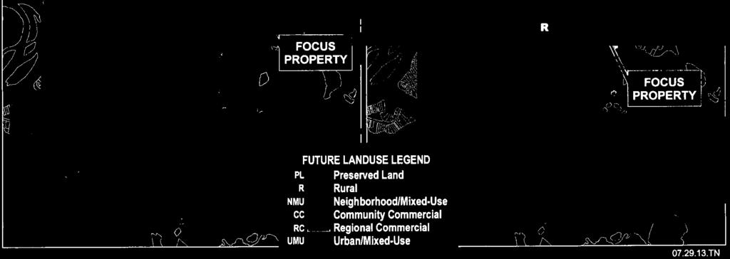
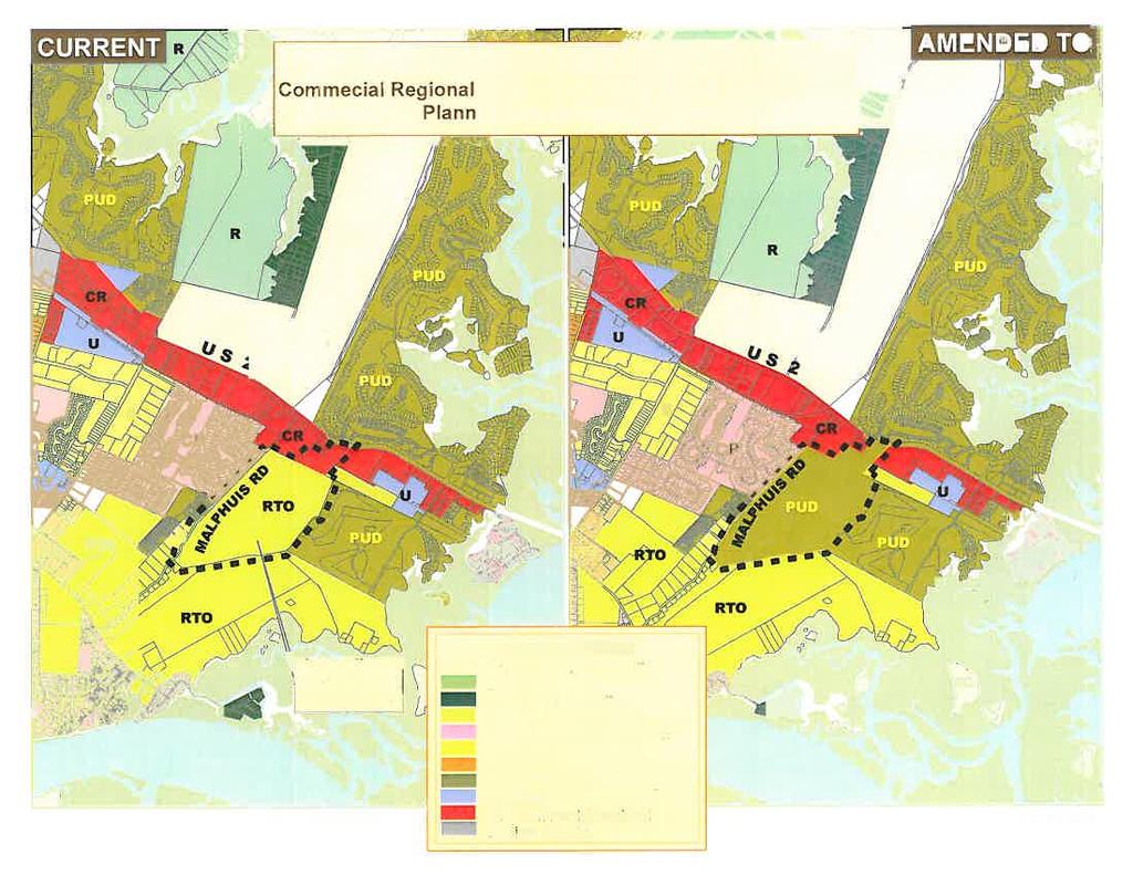
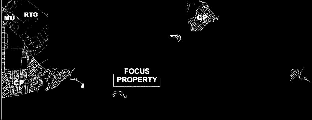
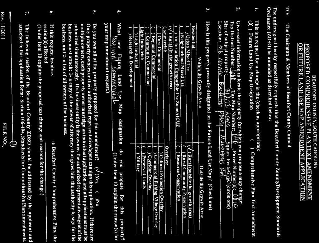
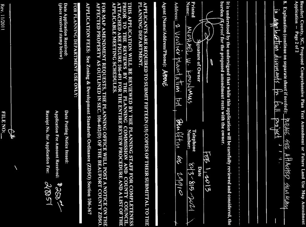
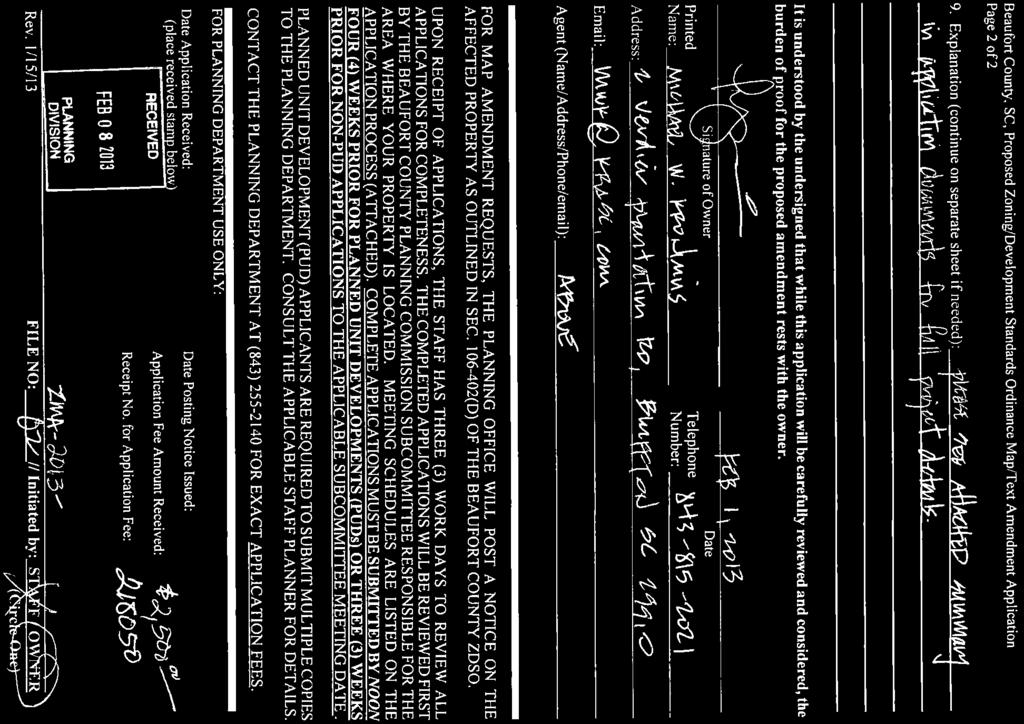
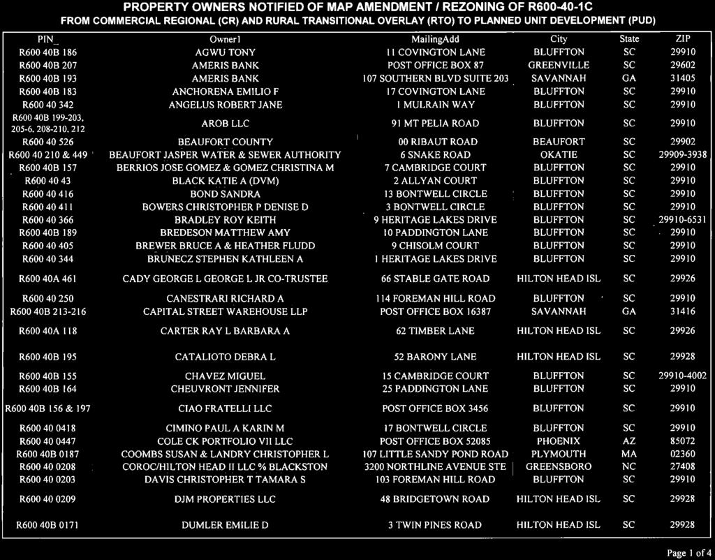
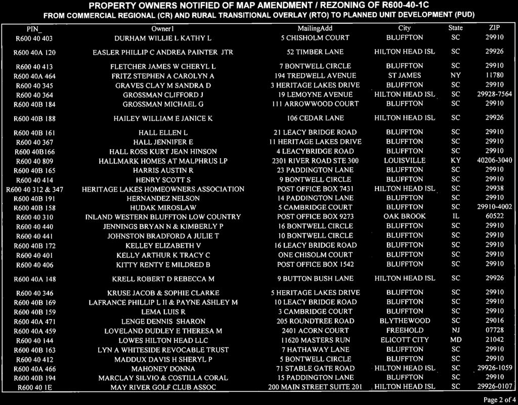
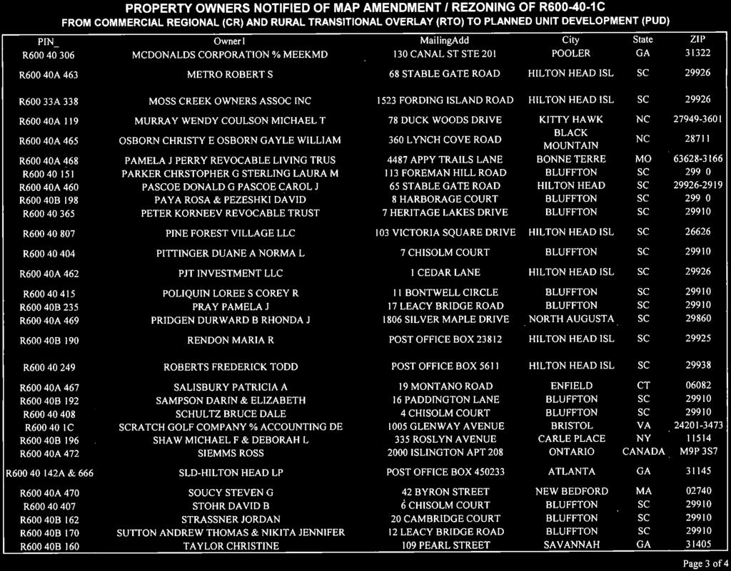
1 PLANNING COMMISSION Thursday, September 5, :00 p.m. Council Chambers, Administration Building 100 Ribaut Road, Beaufort, South Carolina In accordance with South Carolina Code of Laws, 1976, Section (d), as amended, all local media was duly notified of the time, date, place and agenda of this meeting. 1. COMMISSIONER S WORKSHOP 5:30 P.M. Planning Office, Room 115, County Administration Building 2. REGULAR MEETING - 6:00 P.M. Council Chambers 3. CALL TO ORDER 6:00 P.M. 4. PLEDGE OF ALLEGIANCE 5. REVIEW OF MINUTES - June 3, 2013 (backup) 6. CHAIRMAN S REPORT 7. PUBLIC COMMENT ON NON-AGENDA ITEMS 8. PUBLIC HEARING AND RECOMMENDATIONS ON SOUTHERN BEAUFORT COUNTY MAP AMENDMENTS FOR R C-0000 ( ACRES AT THE SOUTHEAST CORNER OF BLUFFTON PARKWAY AND MALPHRUS ROAD); OWNER: SCRATCH GOLF LLC, APPLICANT/AGENT: MICHAEL KRONIMUS (backup): A. Future Land Use Map / Request from Regional Commercial and Rural to Regional Commercial; B. Zoning Map Amendment / Rezoning Request from Commercial Regional and Rural with a Transitional Overlay to Planned Unit Development (PUD). 9. TEXT AMENDMENTS TO THE BEAUFORT COUNTY ZONING AND DEVELOPMENT STANDARDS ORDINANCE/ZDSO: ARTICLE XII. SUBDIVISION DESIGN, DIVISION 3 TYPE OF SUBDIVISION; ARTICLE XIII. SUBDIVISION AND LAND DEVELOPMENT STANDARDS, DIVISION 2 STREET STANDARDS; AND ARTICLE XV. SIGNS, DIVISION 2 STANDARDS (ADDS ADDITIONAL REQUIREMENTS FOR SUBDIVISIONS, STREET DESIGNS AND SIGNS); APPLICANT: STAFF (backup) 10. OTHER BUSINESS A. Discussion regarding eliminating subcommittee meetings B. Next Meeting Monday, October 7, 2013, at 6:00 p.m. 11. ADJOURNMENT COUNTY COUNCIL OF BEAUFORT COUNTY BEAUFORT COUNTY PLANNING DIVISION Multi-Government Center 100 Ribaut Road, Room 115 Post Office Drawer 1228, Beaufort SC Phone: (843) FAX: (843)
2 COUNTY COUNCIL OF BEAUFORT COUNTY BEAUFORT COUNTY PLANNING DIVISION Multi-Government Center 100 Ribaut Road, Room 115 Post Office Drawer 1228, Beaufort SC Phone: (843) FAX: (843) The regular meeting of the Beaufort County Planning Commission (hereinafter Commission ) was held on Monday, June 3, 2013, in County Council Chambers, the Beaufort County Administration Building at 100 Ribaut Road, Beaufort, South Carolina. Members Present: Mr. Robert Semmler, Chairman Mr. John Thomas, Vice Chairman Ms. Jennifer Bihl Mr. Charles Brown Ms. Diane Chmelik Ms. Mary LeGree Mr. Ronald Petit Mr. Edward Riley III Mr. Randolph Stewart Members Absent: None Staff Present: Mr. Anthony J. Criscitiello, Planning Director Ms. Barbara Childs, Admin. Asst. to Planning Director CALL TO ORDER: Chairman Robert Semmler called the meeting to order at approximately 6:00 p.m. PLEDGE OF ALLEGIANCE: Mr. Semmler led those assembled in the Council Chambers with the pledge of allegiance to the U.S.A. flag. REVIEW OF MINUTES: The Commission reviewed their May 2, 2013, meeting minutes. No changes were noted, except the changes agreed upon earlier by the Chairman to correct the date of the meeting in the first paragraph of the minutes. Motion: Vice-Chairman John Thomas made a motion, and Mr. Charles Brown seconded the motion, to accept the May 2, 2013, minutes as corrected. The motion was carried unanimously (FOR: Bihl, Brown, Chmelik, LeGree, Petit, Riley, Semmler, Stewart, and Thomas). CHAIRMAN S REPORT: Mr. Semmler had nothing to report, except the Braves were ahead. PUBLIC COMMENT for items other than agenda items: None were received. PORT ROYAL ISLAND COUNTY ZONING MAP AMENDMENT / REZONING REQUEST FOR MARSH VIEW SUBDIVISION (R A, AND ; 38 RESIDENTIAL LOTS AND ASSOCIATED COMMON AREAS TOTALING ACRES; OFF DORCHESTER DRIVE AND TOMOTLEY, WHITEHALL AND MCCALLEY COURTS, IN THE GRAYS HILL AREA), TO BE REZONED FROM RURAL (R) TO RURAL-RESIDENTIAL (RR); OWNER: FACTORY CREEK LANDING GROUP LLP, APPLICANT/AGENT: STEVEN TULLY
3 June 3, 2013, Beaufort County Planning Commission meeting minutes Page 2 of 2 Mr. Anthony Criscitiello briefed the Commissioners. He noted that this was a map amendment to correct the zoning from Rural to Rural Residential. The 1999 ZDSO created the Rural Residential zone and the properties met the criteria for Rural-Residential zoning. The applicant received a letter from the Planning Department noting the error in the zoning; however, the applicant is asking that the zoning map reflect that the properties are zoned Rural-Residential. Public Comment: None were received, including from the applicant who was present in the audience. Commission discussion included a clarification from the applicant as to the purpose for the map change--to accommodate banking requirements. Motion: Mr. Thomas made a motion, and Ms. Chmelik seconded the motion, to recommend approval to County Council of the Port Royal Island County Zoning Map Amendment / Rezoning Request for the Marsh View Subdivision (R A, and ; 38 residential lots and associated common areas totaling acres; off Dorchester Drive and Tomotley, Whitehall and McCalley Courts, in the Grays Hill area), to be rezoned from Rural (R) to Rural-Residential (RR). No further discussion occurred. The motion was carried unanimously (FOR: Bihl, Brown, Chmelik, LeGree, Petit, Riley, Semmler, Stewart and Thomas). OTHER BUSINESS: Mr. Semmler noted that the next Commission meeting was Monday, July 1, 2013, at 6:00 p.m. ADJOURNMENT: Motion: Mr. Ronald Petit made a motion, and Mr. Charles Brown seconded the motion, to adjourn the meeting. The motion was carried unanimously ((FOR: Bihl, Brown, Chmelik, LeGree, Petit, Riley, Semmler, Stewart and Thomas). The meeting was adjourned at approximately 6:06 p.m. SUBMITTED BY: Barbara Childs, Admin. Assistant to the Planning Director APPROVED: September 5, 2013 Robert Semmler, Beaufort County Planning Commission Chairman

4
5


6
7
8
9
10

11


12


13


14

15


16
17

18
19
20
21
22

23
 Type of Subdivision, Subdivision Design, and")
24 MEMORANDUM To: From: Beaufort County Planning Commission Anthony J. Criscitiello, Planning & Development Director Date: August 22, 2013 Subject: Proposed Amendments to the Zoning & Development Standards Ordinance (ZDSO) Type of Subdivision, Subdivision Design, and Signs ZDSO Sections: Article XII. Subdivision Design, Division 3- Type of Subdivision; Article XIII. Subdivision and Land Development Standards, Division 2 Street Standards; and Article XV. Signs, Division 2 Standards. Summary of the Proposed Amendment: The proposed amendments will allow a new type of subdivision. This is in response to an evolving market trend which the planning department contemplates as a legitimate reason to create these text amendments. The text amendments would accomplish three things: first would be to broaden the concept of what can be considered a subdivision, i.e., a commercial subdivision; the second would allow the County Transportation Engineer additional latitude to consider other methods to provide essential site access where supported by a traffic impact analysis; and the third will allow for signs to be permitted in shopping centers that are developed as a commercial subdivision. Source of Proposed Amendment: The origin of this proposal came from the Development Agreement Subcommittee of the Natural Resources Committee of the Beaufort County Council. Justification: There is an increasing trend from major national retailers in commercial shopping centers to want to own the land the stores reside upon and the parking areas that support the stores. Consequently, shopping center developers and their major retailers want the flexibility to use the subdivision and site plan review process to integrate the two processes together without creating conflicts between zoning standards and subdivision regulations. Often internal setback and buffer yard requirements would cancel out the unified site plan concept inherent in a commercial subdivision within a shopping center. This proposed set of text amendments are designed to remedy that problem. Proposed Amendments: (proposed deletions to the text are shown as strike-through and proposed additions to the text are underlined). Recommendation: The Beaufort County Planning staff recommends approval for the herein attached sections of the Beaufort County ZDSO. Text Amendment for Subdivisions Types, Design & Signs / Page 1 of 5
25 Sec Scope. Sec Major Subdivision. Sec Minor Subdivision. Sec Rural small lot subdivision. Sec Commercial subdivision. Secs Reserved Sec Scope. Article XII. Subdivision Design Division 3. Types of Subdivisions There are three four types of subdivision permitted under this chapter: major, minor, and rural small lot, and commercial. Refer to article III of this chapter regarding review procedures for major or minor subdivisions Sec Commercial Subdivision. (a) Commercial subdivisions are land developments that include master planning and subdividing into two or more lots any tract or parcel of land located in commercial regional, commercial suburban, research and development, light industry, and industrial park districts. These subdivisions are limited to commercial and/or industrial uses only. This type of subdivision includes all of the following: (1) Separate ownership of lots, coupled with undivided interest in common property; (2) Restrictive land use covenants or easements that govern use of both the common area and separate ownership interests; and (3) Management of common property and enforcement of restrictions by a property owners association. (b) A master development plan for the commercial subdivision, which shall show buildout of the project, including proposed lots and outparcels, shall be submitted for Conceptual Development Plan review and approval by the DRT. The master development plan shall be accompanied by a traffic impact analysis (TIA) and include a master signage plan depicting signage to be used by the owners of lots in the commercial subdivision. (c) Commercial subdivisions shall be subject to restrictive land use covenants or easements, which provide for the installation, maintenance, and shared use of infrastructure and common areas among the lots depicted in a commercial subdivision master development plan. Such restrictive covenants or easements shall provide for shared access, ingress, egress, parking, common area ownership and maintenance, utility and stormwater infrastructure, signage in accordance with the master signage plan and landscaping among the lots in the commercial subdivision. Said restrictive land use covenants or easements shall comply with the ZDSO and shall be recorded concurrent with the sale or transfer of any lot within the commercial subdivision. Text Amendment for Subdivisions Types, Design & Signs / Page 2 of 5
26 (d) Except for outparcels, individual lots within a commercial subdivision are exempt from the open space and density, lot and building intensity, and bufferyard and landscaping standards of Article VI; the site capacity and resource protection standards in Article VII, except for tree protection and removal; and parking standards in Article XIII. The intent being that the commercial development will meet these standards as a whole during review of the master development plan, and that subsequent to subdivision, the lots depicted in the master development plan for a commercial subdivision shall be used and shall operate together as a single master planned development. Where applicable; however, individual lots within a commercial subdivision shall meet the Corridor Overlay District Guidelines in Appendix B, except that perimeter buffer requirements (see Appendix B, Sec. 5.A.2.d) shall not apply between individual lots in the commercial subdivision. (e) Amendments to the commercial subdivision, including but not limited to the size, dimension and number of lots depicted therein, shall be approved by the DRT. (f) The original developer of a commercial subdivision may or may not actually develop the entire project to completion. As a special exception to the subdivision process outlined in this Chapter, the developer of a commercial subdivision may sell or transfer ownership of lots within the commercial subdivision in accordance with the following procedures and provisions: (1) Prior to the sale or transfer of lots, the developer shall build any necessary off-site improvements for the development, including those identified in the traffic impact analysis (TIA), water/sewer extensions to the site, etc., or the developer may elect to provide surety in the amount of 125% of the cost estimates for such improvements in accordance with Article XIII, Division 7 (Performance Guarantees). (2) Property covenants and restrictions (see subsection (c) above), must accompany the sale or transfer of any lot within the commercial subdivision restricting the new owner to the development shown on the approved master development plan; (3) The developer shall submit to the ZDA a sworn affidavit from the prospective purchaser of a lot wherein the purchaser waives his or her right to the guarantee of the installation of required improvements afforded through this Chapter for the subdivision of land, and further states that he or she understands that a final development plan application must be submitted and approved, and a development permit issued by the County in accordance with the procedures in Article III (Administrative Procedures) prior to commencement of any development on the lot; (4) The developer shall submit a plat for certification for recording to the ZDA and subsequently record such plat prior to sale or transfer of any lot in the commercial subdivision. Secs Reserved Text Amendment for Subdivisions Types, Design & Signs / Page 3 of 5
27 Article XIII. Subdivision and Land Development Standards Division 2. Street Standards Sec Access. (a) Access to county, state and federal thoroughfares. In subdivisions, access to county, state, and federal thoroughfares shall be provided as follows: (1) Street, driveway, or other access separation along county, state, and federal highways shall be in accordance with the SCDOT, Access and Roadside Management Standards, and county-approved access management plans. In no event, however, shall individual driveways and nonresidential curb cuts be permitted at spacing less than follows: a. Major arterial road (divided four-lane): 1,500 feet. b. Arterial road (two-lane): 800 feet. c. Collector road and all others: 400 feet. (2) Where existing conditions warrant, individual driveways and nonresidential curb cut spacing described in subsection(a)(1) above may be varied by the Beaufort County Traffic Engineer to provide essential site access where supported by an approved traffic impact analysis. (23) If a road can be provided for lots (parcels), they shall be required, rather than permitting the stripping of lots (parcels) along the road frontage with individual and direct access to the roadway. The rural subdivision (subdivision II of division 4 of articles Xii of this chapter) is specifically designed to eliminate stripping of lots. If a property cannot be provided access through adjoining properties, a temporary access may be permitted as provided in subsection (b) of this section. (34) Where a new internal road cannot be provided due to the depth and/or configuration of a parcel, lots (parcels) created along public road rights-of-way shall utilize shared access drives to meet the separation standards in subsection (1). (45) Where lots (parcels) within a major subdivision are created along unpaved public road rights-of-way, the developer shall be required to either pave the portion of the road that fronts the lots per county standards or provide in escrow to the county an amount equal to the paving of that portion of the road. (Note: The remainder of Sec is unaffected.) Text Amendment for Subdivisions Types, Design & Signs / Page 4 of 5
28 Article XV. Signs Division 2. Standards Sec General sign requirements. Sec On-premises signs. Sec Shopping centers, commercial subdivisions or multiple-tenant buildings. Sec Off-premises signs. Sec Illumination. Sec Signage requirements for corridor overlay district. Secs Reserved Sec Shopping centers, commercial subdivisions or multiple-tenant buildings. (a) Identification sign. Shopping centers, commercial subdivisions, malls and multipletenant buildings may erect either one 80-square-foot freestanding ground sign, which may be used as an identification sign, directory listing, or combination thereof, on each street or highway frontage except where the frontage exceeds 500 feet. An additional sign may be allowed provided it does not exceed 80 square feet in area, and the total area of all freestanding signs do not exceed the maximum allowable area as specified in subsection (b) of this section. (b) Total maximum allowable area. The total maximum allowable area shall be as follows: (1) For shopping centers, commercial subdivisions, and/or multiple-tenant buildings fronting on one street or highway, the maximum total freestanding area is 160 square feet. (2) For shopping centers, commercial subdivisions, and/or multiple-tenant buildings fronting on two streets or highways, the maximum total freestanding area is 240 square feet. (3) Individual businesses within a shopping center, commercial subdivision and/or multipletenant building may erect wall and/or projecting signs consistent with section (4) Individual businesses within a complex and individual lots within a commercial subdivision (excluding outparcels) shall not be allowed to have separate freestanding signs. Sec Off-premises signs. (a) Generally. Standards for off-premises signs are as follows: (1) Except for commercial subdivisions subject to the provisions of section , and except as provided for in subsections (a)(7) and (8) of this section, all commercial, offpremises signs are banned in the areas of the county to which this chapter applies. (Note: The remainder of Sec is unaffected. Subsections (a)(7) & (8) are added for reference only.) (7) Back-to-back signs and V-sign structures shall be considered as one sign for purposes of spacing requirements. (8) In order to provide information and directional aid to the general public, directional signs may be erected upon approval of the county only within 300 feet of intersections of major traveled thoroughfares and secondary roads to identify businesses, services, organizations, agencies, facilities, and activities located down the secondary road. Such directional signs shall not be utilized to identify uses on the major traveled thoroughfare. Text Amendment for Subdivisions Types, Design & Signs / Page 5 of 5
PLANNING COMMISSION Monday, May 2, :00 p.m. Council Chambers, Administration Building 100 Ribaut Road, Beaufort, South Carolina
 COUNTY COUNCIL OF BEAUFORT COUNTY BEAUFORT COUNTY PLANNING DIVISION Beaufort County Government Robert Smalls Complex Administration Building, 100 Ribaut Road, Room 115 Mailing: Post Office Drawer 1228,
ARTICLE 759. PD 759. PD 759 was established by Ordinance No , passed by the Dallas City Council on June 27, (Ord. Nos.
 ARTICLE 759. PD 759. SEC. 51P-759.101. LEGISLATIVE HISTORY. PD 759 was established by Ordinance No. 26871, passed by the Dallas City Council on June 27, 2007. (Ord. Nos. 26871; 29304) SEC. 51P-759.102.
ORDINANCE NO. O-5-10
 ORDINANCE NO. O-5-10 AN ORDINANCE OF THE TOWN COMMISSION OF THE TOWN OF PALM BEACH SHORES, FLORIDA, AMENDING THE TOWN CODE OF ORDINANCES AT APPENDIX A. ZONING. SECTION VI. DISTRICT B REGULATIONS BY AMENDING
Section 1: US 19 Overlay District
 Section 1: US 19 Overlay District Section 1.1 Intent and Purpose The purpose of the US Highway 19 Overlay District is to manage access to land development along US Highway 19 in a manner that preserves
A. CONSIDERATION OF THE UNAPPROVED MINUTES OF NOVEMBER 13, 2018
 I. CALL TO ORDER OFFICIAL AGENDA PLANNING & ZONING COMMISSION CITY OF STARKVILLE, MISSISSIPPI MEETING OF TUESDAY, DECEMBER 11, 2018 1ST FLOOR CITY HALL COURT ROOM 110 WEST MAIN STREET AT 5:30 PM II. III.
b) Tangerine Corridor Overlay District 1) Tangerine Corridor District Regulations
 Tangerine Corridor Overlay District 1) Tangerine Corridor District Regulations") Attachment 1 Tangerine Road Corridor Overlay District Section 27.10.D.3.f.vi.b Initiation of Code Amendment September 2, 2014, Planning and Zoning Commission b) Tangerine Corridor Overlay District 1) Tangerine
Attachment 1 Tangerine Road Corridor Overlay District Section 27.10.D.3.f.vi.b Initiation of Code Amendment September 2, 2014, Planning and Zoning Commission b) Tangerine Corridor Overlay District 1) Tangerine
EDGERTON CITY HALL PLANNING COMMISSION MEETING REGULAR SESSION March 12, 2019
 EDGERTON CITY HALL PLANNING COMMISSION MEETING REGULAR SESSION The met in regular session with Chair John Daley calling the meeting to order at 7:00 p.m. All present participated in the Pledge of Allegiance.
Village of Lincolnwood Plan Commission
 Village of Lincolnwood Plan Commission Meeting Thursday, January 3, 2019 7:00 P.M. in the Council Chambers Room Lincolnwood Village Hall - 6900 North Lincoln Avenue 1. Call to Order/Roll Call 2. Pledge
AN ORDINANCE TO AMEND SECTION OF THE RAPID CITY MUNICIPAL CODE TO ALLOW FOR ADMINISTRATIVE DISSOLUTION OF PLANNED DEVELOPMENTS
 Ordinance No. 6231 AN ORDINANCE TO AMEND SECTION 17.50.050 OF THE RAPID CITY MUNICIPAL CODE TO ALLOW FOR ADMINISTRATIVE DISSOLUTION OF PLANNED DEVELOPMENTS WHEREAS, the City of Rapid City has adopted a
Marion County Board of County Commissioners
 Marion County Board of County Commissioners Date: 12/29/2015 P&Z: 12/28/2015 BCC: 1/12/2016 Item Number 160113Z Type of Application Rezoning Request From: A-1 (General Agriculture) To: PUD (Planned Unit
1. Cuyler-Brownsville planned neighborhood conservation (P-N-C) districtphase I (section ). (2) Single-family semiattached dwellings;
 districtphase I (section ). (2) Single-family semiattached dwellings;") Sec. 8-3035. Planned unit development multifamily (PUD-M). A. Purpose. The PUD-M district is intended to allow a variety of residential development including single-family residential, two-family residential,
Sec. 8-3035. Planned unit development multifamily (PUD-M). A. Purpose. The PUD-M district is intended to allow a variety of residential development including single-family residential, two-family residential,
Opening Ceremonies 1. Welcome/Introductions Sharla Bynum 2. Serious Moment of Reflection/Pledge of Allegiance Portia Mila
 South Salt Lake City Council REGULAR MEETING AGENDA Public notice is hereby given that the South Salt Lake City Council will hold a Regular Meeting on Wednesday, August 22, 2018 in the City Council Chambers,
Chapter 100 Planned Unit Development in Corvallis Urban Fringe
 100.100 Scope and Purpose. Chapter 100 Planned Unit Development in Corvallis Urban Fringe (1) All applications for land divisions in the Urban Residential (UR) and Flood Plain Agriculture (FPA) zones within
St. Mary s County Comprehensive Zoning Ordinance Article 1. GENERAL PROVISIONS
 0 0 0 0 ARTICLE. GENERAL PROVISIONS CHAPTER 0 TITLE, PURPOSE AND ORGANIZATION Sections: 0. Title. 0. Authority. 0. Purpose. 0. Organization of the Zoning Ordinance. 0. Official Zoning Map. 0. Applicability.
SUBJECT PARCEL(S) Property Owner(s) TMS Number Approximate Acreage Carolina Park Development, LLC
 Property Owner(s) TMS Number Approximate Acreage Carolina Park Development, LLC") Staff Report Special Planning Commission Meeting November 19, 2014 For reference, the Zoning Code and Land Development Regulations are available online. AGENDA ITEM 5c. SKETCH PLAN APPROVAL REQUEST: Request
Staff Report Special Planning Commission Meeting November 19, 2014 For reference, the Zoning Code and Land Development Regulations are available online. AGENDA ITEM 5c. SKETCH PLAN APPROVAL REQUEST: Request
1. Roll Call. 2. Minutes a. September 24, 2018 Special Joint Meeting with Clay County Planning Commission. 3. Adoption of the Agenda
 1. Roll Call City of Vermillion Planning Commission Agenda 5:30 p.m. Regular Meeting Tuesday, October 9, 2018 City Council Chambers 2 nd Floor City Hall 25 Center Street Vermillion, SD 57069 2. Minutes
ORDINANCE NO. 208 BE IT ORDAINED BY THE CITY COUNCIL OF THE CITY OF UNIVERSITY HEIGHTS, JOHNSON COUNTY, IOWA:
 ORDINANCE NO. 208 AN ORDINANCE AMENDING ORDINANCE NO. 79 (ZONING) TO CREATE A COMMERCIAL HOTEL ZONE AND PERMIT DEVELOPMENT PURSUANT TO A COMMERCIAL HOTEL PUD BE IT ORDAINED BY THE CITY COUNCIL OF THE CITY
Village of Glenview Zoning Board of Appeals
 Village of Glenview Zoning Board of Appeals STAFF REPORT August 20, 2012 TO: Chairman and Zoning Board of Appeals Commissioners FROM: Planning and Economic Development Department CASE #: Z2012-025 LOCATION:
CITY OF COCOA BEACH DEPARTMENT OF DEVELOPMENT SERVICES PLANNING BOARD BRIEFING Meeting Date: April 3, 2017 Agenda Item: C.1
 REQUEST: Comprehensive Plan Amendment and Rezoning request to change the Future Land Use from High Density Residential & Professional to General Commercial and change the Zoning designation from RM-2 Multifamily-
ARTICLE 14 PLANNED UNIT DEVELOPMENT (PUD) DISTRICT
 DISTRICT") ARTICLE 14 PLANNED UNIT DEVELOPMENT (PUD) DISTRICT Section 14.01 Intent. It is the intent of this Article to allow the use of the planned unit development (PUD) process, as authorized by the Michigan Zoning
ARTICLE 14 PLANNED UNIT DEVELOPMENT (PUD) DISTRICT Section 14.01 Intent. It is the intent of this Article to allow the use of the planned unit development (PUD) process, as authorized by the Michigan Zoning
RESOLUTION NO. RESOLUTION APPROVING ZONING PETITION 84-71, Special Exception. WHEREAS, the Board of County Commissioners, as the governing
 /. ;C- C, i RESOLUTION NO. R-@+-l2?8 RESOLUTION APPROVING ZONING PETITION 84-71, Special Exception WHEREAS, the Board of County Commissioners, as the governing body, pursuant to the authority vested in
PUBLIC NOTICE & AGENDA PLAN COMMISSION City Hall Forum State Street, Beloit, WI :00 PM Wednesday, November 07, 2018
 PUBLIC NOTICE & AGENDA PLAN COMMISSION City Hall Forum - 100 State Street, Beloit, WI 53511 7:00 PM Wednesday, November 07, 2018 1. CALL TO ORDER AND ROLL CALL 2. MINUTES 2.a. Consideration of the Minutes
A. CONSIDERATION OF THE UNAPPROVED MINUTES OF DECEMBER 11, 2018
 I. CALL TO ORDER OFFICIAL AGENDA PLANNING & ZONING COMMISSION CITY OF STARKVILLE, MISSISSIPPI MEETING OF TUESDAY, JANUARY 8, 2018 1ST FLOOR CITY HALL COURT ROOM 110 WEST MAIN STREET AT 5:30 PM II. III.
ARTICLE 15. RULES, REGULATIONS AND DEFINITIONS
 ARTICLE 15. RULES, REGULATIONS AND DEFINITIONS Section 1. Interpretation and Construction: The following rules and regulations regarding interpretation and construction of the Ulysses-Grant County, Kansas,
ARTICLE 3 DEFINITIONS
 Sections: 3-1 Rules of Construction 3-2 Definitions ARTICLE 3 DEFINITIONS SECTION 3-1 RULES OF CONSTRUCTION 3-101. a. The language set forth in these regulations shall be interpreted in accordance with
FREQUENTLY USED PLANNING & ZONING TERMS
 City Of Mustang FREQUENTLY USED PLANNING & ZONING TERMS Abut: Having property lines, street lines, or zoning district lines in common. Accessory Structure: A structure of secondary importance or function
Eric Larson, Division Director Environmental Engineering 2. PRESENTATION / RECAP MAY 2, 2016 MEETING OF THE PLANNING COMMISSION
 D. PAUL SOMMERVILLE CHAIRMAN GERALD W. STEWART VICE CHAIRMAN COUNCIL MEMBERS CYNTHIA M. BENSCH RICK CAPORALE GERALD DAWSON BRIAN E. FLEWELLING STEVEN G. FOBES ALICE G. HOWARD WILLIAM L. MCBRIDE STEWART
Spartanburg County Planning and Development Department
 Spartanburg County Planning and Development Department MINUTES Planning and Development Commission County Council Chambers, 4:30 p.m. June 6, 2017 Members Present: Members Absent: Staff Present: Whit Kennedy,
NORTH OGDEN PLANNING COMMISSION MEETING MINUTES. February 18, 2015
 NORTH OGDEN PLANNING COMMISSION MEETING MINUTES February 18, 2015 The North Ogden Planning Commission convened in a regular meeting on February 18, 2015 at 6:30 p.m. in the North Ogden City Municipal Building,
JOINT PLANNING BOARD APPLICATION FORM
 JOINT PLANNING BOARD APPLICATION FORM TOWNSHIP OF RIVER VALE 406 RIVERVALE ROAD RIVER VALE, NJ 07675 The application, with supporting documentation, must be filed with the Administrative Officer to the
PLANNING AND ZONING DEPARTMENT
 Town of Minturn Development Review Process: Guide To Planned Unit Developments (Concept Plan) This guide describes the Planned Unit Development Process. This guide should be utilized in conjunction with
ORDINANCE WHEREAS, the adoption of this Ordinance shall not be construed as an admission that the aforesaid claim has merit or is correct; and
 ORDINANCE 12-24 AN ORDINANCE OF THE CITY OF WINTER GARDEN, FLORIDA, REPEALING ORDINANCE 12-02 AND REPLACING IT WITH THE AMENDMENTS TO ARTICLE V OF CHAPTER 118 OF THE WINTER GARDEN CODE OF ORDINANCES CONTAINED
-MENDOCINO COUNTY PLANNING AND BUILDING SERVICES- DIVISION OF LAND REGULATIONS TITLE 17
 ARTICLE VI -- GENERAL REGULATIONS AND PROVISIONS Sec. 17-50. Sec. 17-51 General Plan. Sec. 17-52 Lot and Block Design and Configuration. Sec. 17-53 Lot Access. Sec. 17-54 Private Roads. Sec. 17-55 Water
ARTICLE 15 - PLANNED UNIT DEVELOPMENT
 Section 15.1 - Intent. ARTICLE 15 - PLANNED UNIT DEVELOPMENT A PUD, or Planned Unit Development, is not a District per se, but rather a set of standards that may be applied to a development type. The Planned
4. No subdivision shall contain a lot that is less than the minimum dimensions set out in the applicable zoning district regulations.
 Article 8 Subdivisions Part 1 Major and Minor Subdivisions Section 161: Purpose The intent of these regulations is to protect the public health, safety and welfare by providing for the orderly growth and
SECTION 7000 LAND DEVELOPMENT REQUIREMENTS
 SECTION 7000 LAND DEVELOPMENT REQUIREMENTS 7000 LAND DEVELOPMENT REQUIREMENTS... 1 7001 LEGISLATIVE AUTHORITY... 1 7001.1 LAND DEVELOPMENT... 1 7001.1.1 Title 40, Idaho Code... 1 7001.1.2 Idaho Code 40-1415
MINUTES. SUBJECT: Approval of Minutes Regular Meeting December 8, 2015
 MINUTES The Town of Manteo Planning and Zoning Board met in Regular Session on Tuesday, January 12, 2016 at 6:00 p.m. at the Meeting Room at the Manteo Town Hall 407 Budleigh Street, Manteo, NC The following
Year. Simply Dental PUD. Town of Fishers Planned Development Ordinance No v
 Simply Dental PUD v. 02.03.14 Town of Fishers Planned Development Ordinance No. 010614 1.01 Declaration, Purpose and Intent, and Permitted Uses Declaration Ordinance No. 010614 (this Ordinance") Adopted:
SECTION 10.7 R-PUD (RESIDENTIAL PLANNED UNIT DEVELOPMENT) ZONE
 ZONE") Article X Zones 10-20 SECTION 10.7 R-PUD (RESIDENTIAL PLANNED UNIT DEVELOPMENT) ZONE A. PURPOSE AND INTENT: The R-PUD Residential PUD Zone is intended to provide alternative, voluntary zoning procedures
Article X Zones 10-20 SECTION 10.7 R-PUD (RESIDENTIAL PLANNED UNIT DEVELOPMENT) ZONE A. PURPOSE AND INTENT: The R-PUD Residential PUD Zone is intended to provide alternative, voluntary zoning procedures
Application: Z Owner: D & S Schulz Enterprises Ltd. Address: 196 Cariboo Rd Applicant: Siegfried Schulz. RU6 - Two Dwelling Housing
 REPORT TO COUNCIL Date: October 3, 2016 RIM No. 1250-30 To: From: City Manager Community Planning Department (TY) Application: Z16-0018 Owner: D & S Schulz Enterprises Ltd Address: 196 Cariboo Rd Applicant:
ASPEN GLEN PUD. Eighth Amended PUD Guidelines
 ASPEN GLEN PUD Eighth Amended PUD Guidelines A. Applicability Statement To carry out the purposes and provisions of the Garfield County Zoning Regulations, as amended, The Aspen Glen Club Planned Unit
Regular Meeting and Public Hearing of the Zoning Subcommittee
 Regular Meeting and Public Hearing of the Zoning Subcommittee Tuesday, September 05, 2017 7:00 PM Council Chambers, City Hall, 2nd Floor, 27 West Main Street, New Britain, Connecticut NOTICE - The Common
FRANKLIN COUNTY PLANNING BOARD. May 8, 2018
 FRANKLIN COUNTY PLANNING BOARD May 8, 2018 The Franklin County Planning Board held its regular monthly meeting on Tuesday, May 8, 2018 in the Franklin County Administration Building, Commissioners Meeting
TOWNSHIP OF MANALAPAN ORDINANCE NO
 TOWNSHIP OF MANALAPAN ORDINANCE NO. 2018-14 AN ORDINANCE OF THE TOWNSHIP COMMITTEE OF THE TOWNSHIP OF MANALAPAN, COUNTY OF MONMOUTH, STATE OF NEW JERSEY, AMENDING AND SUPPLEMENTING CHAPTER 95, DEVELOPMENT
PUD, HPUD, OSC Rezoning & Conceptual Plan Application (Planned Unit Development, Haggerty Road Planned Unit Development, Open Space Community)
") Township Use Only RZ #: Date: Hearing Date: Fee Paid: PUD, HPUD, OSC Rezoning & Conceptual Plan Application (Planned Unit Development, Haggerty Road Planned Unit Development, Open Space Community) Project
Township Use Only RZ #: Date: Hearing Date: Fee Paid: PUD, HPUD, OSC Rezoning & Conceptual Plan Application (Planned Unit Development, Haggerty Road Planned Unit Development, Open Space Community) Project
PLANNED UNIT DEVELOPMENT (PUD) AREA PLAN/REZONING REVIEW PROCEDURE
 AREA PLAN/REZONING REVIEW PROCEDURE") PLANNED UNIT DEVELOPMENT (PUD) AREA PLAN/REZONING REVIEW PROCEDURE Professional inquiries will be made to our Township Planning Consultant, Township Engineer, and Township Attorney to get their opinions
PLANNED UNIT DEVELOPMENT (PUD) AREA PLAN/REZONING REVIEW PROCEDURE Professional inquiries will be made to our Township Planning Consultant, Township Engineer, and Township Attorney to get their opinions
FUTURE LAND USE MAP AMENDMENT AND ZONE CHANGE STAFF REPORT
 2017-14-LUM & 2017-79-Z-CO / WB Page 1 of 12 UTURE LAND USE MAP AMENDMENT AND ZONE CHANGE STA REPORT Docket Numbers: 2017-14-LUM and 2017-79-Z-CO/WB Public Hearing Date: November 16, 2017 Pre-Application
Nassau County Department of Planning & Economic Opportunity Nassau Place Yulee, Florida 32097
 Nassau County Department of Planning & Economic Opportunity 96161 Nassau Place Yulee, Florida 32097 APPLICATION AND INSTRUCTIONS FOR FUTURE LAND USE MAP AMENDMENT (TEN (10) ACRES OR MORE) NOTICE: Florida
Meeting Announcement and Agenda Mt. Pleasant Zoning Board of Appeals. Wednesday, April 25, :00 p.m. City Hall Commission Chamber
 Meeting Announcement and Agenda Mt. Pleasant Zoning Board of Appeals Wednesday, April 25, 2018-7:00 p.m. City Hall Commission Chamber I. Roll Call: Assmann, Berkshire, Friedrich, Orlik, Raisanen, White
CHAPTER SUBDIVISION AND PARTITION REQUIREMENTS
 CHAPTER 17.172 SUBDIVISION AND PARTITION REQUIREMENTS Section Title Page 17.172.010 Purpose 2 17.172.020 General Definitions 2 Article I. General Regulations 17.172.040 Considerations for Approval or Denial
I. Requirements for All Applications. C D W
 108-16.1. Application checklists. Checklist for Required Submissions to the Planning Board or Zoning Board of Adjustment of Monroe Township All required submissions are to be made to the Administrative
REPORT OF THE PLANNING AND DEVELOPMENT DEPARTMENT FOR APPLICATION FOR REZONING ORDINANCE TO PLANNED UNIT DEVELOPMENT MAY 18, 2017
 BEL REPORT OF THE PLANNING AND DEVELOPMENT DEPARTMENT FOR APPLICATION FOR REZONING ORDINANCE 2016-805 TO PLANNED UNIT DEVELOPMENT MAY 18, 2017 The Planning and Development Department hereby forwards to
ARTICLE IV: DEVELOPMENT STANDARDS
 ARTICLE IV: DEVELOPMENT STANDARDS IV-53 409 PRIVATE STREETS A private street means any way that provides ingress to, or egress from, property by means of vehicles or other means, or that provides travel
Town of Norwich, Vermont SUBDIVISION REGULATIONS
 Town of Norwich, Vermont SUBDIVISION REGULATIONS Adopted: August 6, 2002 Amended: February 8, 2006 Prepared by Norwich Planning Commission with the assistance of: Burnt Rock Inc. A ssociates in Community
PUD Ordinance - Caravelle #2 of 2002
 PUD Ordinance - Caravelle #2 of 2002 CASCADE CHARTER TOWNSHIP Ordinance # 2 of 2002 AN ORDINANCE TO AMEND THE CASCADE CHARTER TOWNSHIP ZONING ORDINANCE AND ZONING MAP TO ESTABLISH THE Caravelle Village
Nassau County Single Land Split Application
 NASSAU COUNTY DEPARTMENT OF PLANNING AND ECONOMIC OPPORTUNITY FLORIDA Nassau County Single Land Split Application Taco E. Pope, AICP, Director 96161 Nassau Place Yulee, Florida 32097 (904) 530-6300 APPLICATION
THE AREA PLAN COMMISSION OF ST. JOSEPH COUNTY, IN AGENDA
 THE AREA PLAN COMMISSION OF ST. JOSEPH COUNTY, IN AGENDA Tuesday, June 20, 2017 Fourth-Floor Council Chambers 3:30 p.m. County-City Building, South Bend, IN PUBLIC HEARINGS: 1. Rezonings: A. A combined
ORDINANCE NUMBERb5"- 03
 ORDINANCE NUMBERb5"- 03 AMENDMENTS TO THE MASON COUNTY DEVELOPMENT REGULATIONS AND TITLE 16 (PLATS AND SUBDIVISIONS) REGARDING BOUNDARY LINE ADJUSTMENTS. AN ORDINANCE amending the Mason County Development
Subdivision and Land Development Regulations. Jefferson County, West Virginia
 Subdivision and Land Development Regulations Jefferson County, West Virginia Adopted October 9, 2008 Amended April 16, 2015 Amendment Reference This document contains additions and amendments approved
Staff Planner Carolyn A.K. Smith
 Applicant Property Owner, Pamela K. & Steven A. Gray Public Hearing April 13, 2016 City Council Election District Princess Anne Agenda Item 8 Request Modification of Proffers (Modification to the proffer
Midwest City, Oklahoma Zoning Ordinance
 2010 Midwest City, Oklahoma Zoning Ordinance 9/2/2010 Table of Contents Section 1. General Provisions... 5 1.1. Citation... 5 1.2. Authority... 5 1.3. Purpose... 5 1.4. Nature and Application... 5 1.5.
Lincoln County Board of Commissioner s Agenda Item Cover Sheet
 Lincoln County Board of Commissioner s Agenda Item Cover Sheet Board Meeting Date: Agenda Item Type: Consent Agenda: Public Hearing: Regular Agenda: Presentation Time (est): Submitting Person: Phone Number/Ext:
CITY OF SPRINGDALE, OHIO SPRINGDALE BUILDING DEPARTMENT SPRINGFIELD PIKE SPRINGDALE, OHIO TELEPHONE: (513)
") CITY OF SPRINGDALE, OHIO SPRINGDALE BUILDING DEPARTMENT 11700 SPRINGFIELD PIKE SPRINGDALE, OHIO 45246 TELEPHONE: (513) 346-5730 SUBMISSION REQUIREMENTS AND INSTRUCTIONS FOR FINAL PUD/TRANSITION DISTRICT
CITY OF SPRINGDALE, OHIO SPRINGDALE BUILDING DEPARTMENT 11700 SPRINGFIELD PIKE SPRINGDALE, OHIO 45246 TELEPHONE: (513) 346-5730 SUBMISSION REQUIREMENTS AND INSTRUCTIONS FOR FINAL PUD/TRANSITION DISTRICT
THE COUNTY BOARD OF SUPERVISORS OF THE COUNTY OF DOUGLAS DOES ORDAIN AS FOLLOWS:
 8.1 SUBDIVISION CONTROL ORDINANCE THE COUNTY BOARD OF SUPERVISORS OF THE COUNTY OF DOUGLAS DOES ORDAIN AS FOLLOWS: SECTION I. GENERAL INTERPRETATION This ordinance shall not repeal, impair or modify private
9. REZONING NO Vicinity of the northwest corner of 143 rd Street and Metcalf Avenue
 9. REZONING NO. 2002-15 Vicinity of the northwest corner of 143 rd Street and Metcalf Avenue 1. APPLICANT: Andrew Schlagel is the applicant for this request. 2. REQUESTED ACTION: The applicant is requesting
ARTICLE VI. SUBDIVISION STANDARDS, PUBLIC
 ARTICLE VI. SUBDIVISION STANDARDS, PUBLIC IMPROVEMENTS, AND DESIGN REQUIREMENTS ARTICLE VI. SUBDIVISION STANDARDS, PUBLIC IMPROVEMENTS, AND DESIGN REQUIREMENTS DIVISION 1. GENERAL PROVISIONS Sec. 21-6100.
Proposed Overland Park Kansas Ordinance RE-1 Residential Estates Community
 18.171 RE-1 Residential Estate Community 18.171.010 Statement of intent. The zoning of property as RE-1, (Residential Estates Community, 1 dwelling unit per Gross acre density), is intended to provide
Subdivision and Land Development Regulations. Jefferson County, West Virginia
 Subdivision and Land Development Regulations Jefferson County, West Virginia Adopted October 9, 2008 Amended September 29, 2016 Amendment Reference This document contains additions and amendments approved
RP-2, RP-3, RP-4, AND RP-5 PLANNED RESIDENTIAL DISTRICTS
 6.10 - RP-2, RP-3, RP-4, AND RP-5 PLANNED RESIDENTIAL DISTRICTS 6.10.1 GENERAL DESCRIPTION: 6.10.1.1 The regulations established in this Section are intended to provide optional methods of land development
MINUTES OF THE TOWN OF LADY LAKE REGULAR PLANNING AND ZONING BOARD MEETING LADY LAKE, FLORIDA. May 8, :30 p.m.
 MINUTES OF THE TOWN OF LADY LAKE REGULAR PLANNING AND ZONING BOARD MEETING LADY LAKE, FLORIDA May 8, 2017 5:30 p.m. The Planning and Zoning Board Meeting was held in the Town Hall Commission Chambers at
INDIAN RIVER COUNTY, FLORIDA. The Honorable Members of the Planning and Zoning Commission DEPARTMENT HEAD CONCURRENCE
 Public Hearing Legislative INDIAN RIVER COUNTY, FLORIDA M E M O R A N D U M TO: The Honorable Members of the Planning and Zoning Commission DEPARTMENT HEAD CONCURRENCE Robert M. Keating, AICP; Community
City of Oshkosh Zoning Update
 City of Oshkosh Zoning Update The Zoning Rewrite Process Commenced in June of 2013 with selection of Vandewalle and Associates as zoning rewrite consultants. Consultants, City Staff, Plan Commission, and
Sec Planned unit development (PUD) zoning district requirements and procedures.
 zoning district requirements and procedures.") Sec. 10-6.696. Planned unit development (PUD) zoning district requirements and procedures. (a) Purpose and intent of district. The planned unit development (PUD) zoning district is intended to provide
Sec. 10-6.696. Planned unit development (PUD) zoning district requirements and procedures. (a) Purpose and intent of district. The planned unit development (PUD) zoning district is intended to provide
CITY OF SPRINGDALE, OHIO SPRINGDALE BUILDING DEPARTMENT SPRINGFIELD PIKE SPRINGDALE, OHIO TELEPHONE: (513)
") CITY OF SPRINGDALE, OHIO SPRINGDALE BUILDING DEPARTMENT 11700 SPRINGFIELD PIKE SPRINGDALE, OHIO 45246 TELEPHONE: (513) 346-5730 SUBMISSION REQUIREMENTS AND INSTRUCTIONS FOR MINOR REVISIONS TO PUD/TRANSITION
CITY OF SPRINGDALE, OHIO SPRINGDALE BUILDING DEPARTMENT 11700 SPRINGFIELD PIKE SPRINGDALE, OHIO 45246 TELEPHONE: (513) 346-5730 SUBMISSION REQUIREMENTS AND INSTRUCTIONS FOR MINOR REVISIONS TO PUD/TRANSITION
TOWN OF OCEAN ISLE BEACH
 TOWN OF OCEAN ISLE BEACH PLANNED UNIT DEVELOPMENT ORDINANCE ADOPTED IN EFFECT FEBRUARY 13, 2001 This ordinance has been prepared by the Ocean Isle Beach Planning & Inspections Department. Section 66-55.
Spartanburg County Planning and Development Department
 Spartanburg County Planning and Development Department MINUTES Planning and Development Commission County Council Chambers, 4:30 p.m. June 05, 2018 Members Present: Members Absent: Staff Present: Whit
APPLICATION PROCEDURES FOR A MAJOR SUBDIVISION PRELIMINARY PLAT
 APPLICATION PROCEDURES FOR A DEFINITION: The subdivision of a tract of land into at least three (3) residential, commercial, or industrial parcels, including the remainder of the original parcel, fronting
CITY OF SPRINGDALE, OHIO SPRINGDALE BUILDING DEPARTMENT SPRINGFIELD PIKE SPRINGDALE, OHIO TELEPHONE: (513)
") CITY OF SPRINGDALE, OHIO SPRINGDALE BUILDING DEPARTMENT 11700 SPRINGFIELD PIKE SPRINGDALE, OHIO 45246 TELEPHONE: (513) 346-5730 SUBMISSION REQUIREMENTS AND INSTRUCTIONS FOR DEVELOPMENT PLAN APPROVAL An
CITY OF SPRINGDALE, OHIO SPRINGDALE BUILDING DEPARTMENT 11700 SPRINGFIELD PIKE SPRINGDALE, OHIO 45246 TELEPHONE: (513) 346-5730 SUBMISSION REQUIREMENTS AND INSTRUCTIONS FOR DEVELOPMENT PLAN APPROVAL An
ARTICLE 143. PD 143.
 ARTICLE 143. PD 143. SEC. 51P-143.101. LEGISLATIVE HISTORY. PD 143 was established by Ordinance No. 17685, passed by the Dallas City Council on February 2, 1983. Ordinance No. 17685 amended Ordinance No.
1101 MAIN STREET ANDREWS NC PHONE FAX MAYOR NANCY J. CURTIS MEMORANDUM
 1101 MAIN STREET ANDREWS NC 28901 PHONE 828-321-3113 FAX 828-321-4159 MAYOR NANCY J. CURTIS ALDERMAN RAY FRAZIER ALDERMAN JERRY PULLIUM ALDERMAN GARY JAMES ALDERMAN PHIL HORTON MEMORANDUM March 7, 2017
ARTICLE 887. PD 887. Valley View - Galleria Area Special Purpose District
 ARTICLE 887. PD 887. Valley View - Galleria Area Special Purpose District SEC. 51P-887.101. LEGISLATIVE HISTORY. PD 887 was established by Ordinance No. 29032, passed by the Dallas City Council on June
Cover Letter with Narrative Statement
 Cover Letter with Narrative Statement March 31, 2017 rev July 27, 2017 RE: Rushton Pointe Residential Planned Unit Development Application for Public Hearing for RPUD Rezone PL2015 000 0306 Mr. Eric Johnson,
CLEARFIELD CITY COUNCIL AGENDA AND SUMMARY REPORT July 31, 2018 SPECIAL POLICY SESSION
 CLEARFIELD CITY COUNCIL AGENDA AND SUMMARY REPORT July 31, 2018 SPECIAL POLICY SESSION Meetings of the City Council of Clearfield City may be conducted via electronic means pursuant to Utah Code Ann. 52-4-207
Appendix A. Definitions
 Definitions 1. Terms Defined. Words contained in this are those having a special meaning relative to the purposes of this Ordinance. Words not listed in this section shall be defined by reference to: (1)
R E S O L U T I O N. 2. Development Data Summary:
 R E S O L U T I O N WHEREAS, the Prince George s County Planning Board has reviewed Special Permit Application No. SP-170001, Mama s Care Assisted Living Facility, requesting to expand an existing congregate
STRABAN TOWNSHIP PLANNING COMMISSION Alan Zepp, George Mauser, Patt Kimble, Sharon Hamm, John Boblits
 STRABAN TOWNSHIP PLANNING COMMISSION Alan Zepp, George Mauser, Patt Kimble, Sharon Hamm, John Boblits The Straban Township Planning Commission met this date, as publicly advertised, at 7:00 p.m. in the
PALM BEACH COUNTY ENGINEERING DEPARTMENT. ZONING COMMISSION SUBDIVISION VARIANCE STAFF REPORT October 1, 2015
 PALM BEACH COUNTY ENGINEERING DEPARTMENT ZONING COMMISSION SUBDIVISION VARIANCE STAFF REPORT October 1, 2015 APPLICATION NO. CODE REQUIRED PROPOSED VARIANCE SECTION SD-147 11.E.9.B.2 When lots are platted
Request Modification of Proffers Modification of Conditions (Bulk Storage Yard) Staff Recommendation Approval. Staff Planner Marchelle Coleman
 Staff Recommendation Approval. Staff Planner Marchelle Coleman") Applicant & Property Owner Public Hearing October 10, 2018 City Council Election District Princess Anne Agenda Item 6 Request Modification of Proffers Modification of Conditions (Bulk Storage Yard) Staff
Applicant & Property Owner Public Hearing October 10, 2018 City Council Election District Princess Anne Agenda Item 6 Request Modification of Proffers Modification of Conditions (Bulk Storage Yard) Staff
PLANNING COMMISSION REPORT REGULAR AGENDA
 PP-4-4-11 Item No. 9-1 PLANNING COMMISSION REPORT REGULAR AGENDA PC Staff Report 06/22/11 ITEM NO 9: PRELIMINARY PLAT; KASOLD WATER TOWER ADDITION; SE OF TAM O SHANTER & KASOLD DR (MKM) PP-4-4-11: Consider
Summary of Recommended Changes to the Town of Ballston Zoning Law and Key Items for Ongoing Discussion
 Summary of Recommended Changes to the Town of Ballston and Key Items for Ongoing Discussion Major Themes Incorporated to Bring Zoning into Consistency with Comprehensive Plan 1. Removed PUDD as allowable
The requested rezoning would be consistent with the City of Wilmington Focus Area of Welcoming Neighborhoods and Public Spaces.
 ITEM PH3 OFFICE OF THE CITY MANAGER (910) 341-7810 FAX(910)341-5839 TDD (910)341-7873 1/6/2015 City Council City Hall Wilmington, North Carolina 28401 Dear Mayor and Councilmembers: Attached for your consideration
ZONING AMENDMENT & SUBDIVISION STAFF REPORT Date: November 3, 2016
 ZONING AMENDMENT & SUBDIVISION STAFF REPORT Date: November 3, 2016 APPLICANT NAME SUBDIVISION NAME David Shumer 5955 Airport Subdivision CITY COUNCIL DISTRICT District 6 5955 Airport Boulevard, 754 Linlen
MIXED USE DEVELOPMENT AGREEMENT
 MIXED USE DEVELOPMENT AGREEMENT THIS MIXED USE DEVELOPMENT AGREEMENT (hereinafter "Agreement") made and entered into this day of, 2007, pursuant to Section 205-30 of the Zoning Ordinances of the City of
ORDINANCE NO AN ORDINANCE OF THE CITY OF SOUTH SALT LAKE CITY COUNCIL AMENDING CHAPTER SUBDIVISION AND DEVELOPMENT STANDARDS
 ORDINANCE NO. 2018- AN ORDINANCE OF THE CITY OF SOUTH SALT LAKE CITY COUNCIL AMENDING CHAPTER 15.12 -- SUBDIVISION AND DEVELOPMENT STANDARDS WHEREAS, the City Council is authorized by state law to enact
Article 2 Application Type and Standards Requirements
 Article 1 Article 2 Division 1 Application Type and Standards Requirements General Provisions Sec. 2.1.1 Division 2 Division 3 Division 4 Division 5 Division 6 Division 7 Division 8 Division 9 Sec. 2.9.1
Village of Glenview Plan Commission
 Village of Glenview Plan Commission STAFF REPORT June 24, 2014 TO: Chairman and Plan Commissioners CASE #: P2014-026 FROM: Community Development Department CASE MANAGER: Tony Repp, Planner SUBJECT: Final
PLANNED DEVELOPMENT DISTRICT STANDARDS. Cadence Site
 PLANNED DEVELOPMENT DISTRICT STANDARDS Cadence Site A Planned Development District 1. Statement of General Facts, Conditions and Objectives Property Size: Approximately 57.51 Acres York County Tax Map
NASSAU COUNTY BUILDING DEPARTMENT MOBILE/MANUFACTURED HOME APPLICATION CHECKLIST
 Permit # Ap# NASSAU COUNTY BUILDING DEPARTMENT MOBILE/MANUFACTURED HOME APPLICATION CHECKLIST New Replacement Single Wide Double Wide Triple Wide Quad Mftr d Add INSTRUCTIONS: Complete Section A only.
ORDINANCE NO AN ORDINANCE AMENDING THE CODE OF ORDINANCES OF THE CITY OF PORT ARANSAS, TEXAS, BY ADOPTING A NEW CHAPTER
 ORDINANCE NO. 2008-09 AN ORDINANCE AMENDING THE CODE OF ORDINANCES OF THE CITY OF PORT ARANSAS, TEXAS, BY ADOPTING A NEW CHAPTER TWENTY-SIX CONCERNING IMPACT FEES FOR ROADWAY FACILITIES; INCORPORATING
MEETING MINUTES GRAND HAVEN CHARTER TOWNSHIP PLANNING COMMISSION JULY 6, 2015
 MEETING MINUTES GRAND HAVEN CHARTER TOWNSHIP PLANNING COMMISSION JULY 6, 2015 I. CALL TO ORDER LaMourie called the meeting of the Grand Haven Charter Township Planning Commission to order at 7:30 p.m.