FUTURE LAND USE. City of St. Augustine Comprehensive Plan EAR-Based Amendments
|
|
|
- Barnard Ball
- 5 years ago
- Views:
Transcription
1 FUTURE LAND USE City of St. Augustine Comprehensive Plan EAR-Based Amendments
2 Future Land Use Element FLU Goal To create an environment within the City and adjacent areas in which its residents have the opportunity to maximize the potential for economic benefit, and the enjoyment of natural resources, while minimizing the threat to health, safety and welfare posed by hazards, nuisances, incompatible land uses, and environmental degradation. FLU Objective 1 The Future Land Use Map and subsequent amendments to it shall be adopted and implemented in a manner consistent with topography, soil conditions, and the availability of facilities and services to support such development. The measurable targets for this objective are: (1) the number of development proposals reviewed for compliance with the Future Land Use Plan as implemented by the city's development regulations contained in the City Code; and (2) approval of large scale comprehensive plan amendments by DCA, and adoption of small scale comprehensive plan amendments by the City according to the requirements contained in the Rules and Florida Statutes, and consistent with the adopted Comprehensive Plan. FLU Policy 1.1 The City shall continue to implement the adopted comprehensive plan by including all land development regulations governing the use of land in the City Code. All applications for development shall be subject to site plan review by the City. Site plan review shall consist of review of the development proposal for compliance with all applicable chapters of the City Code including but not limited to land development regulations relating to: zoning and on-site parking; environmental protection and conservation overlay zones; concurrency management and on-site storm drainage; signs; landscaping; subdivisions; building code and coastal construction code; utilities - potable water, sanitary sewer, solid waste and city storm sewer; archaeology; and flood control. Building permits shall not be issued which result in a reduction of the level of service for the affected public facilities below the adopted levels of service standards. Ordinances amending the City Code shall be codified at least annually. The City Code shall be on display for the public in the City Clerk's office. FLU Policy 1.2 This Plan incorporates two (2) planning periods (2015 and 2030), of which policies, unless otherwise specified, shall apply through the year The Five-Year Schedule of Capital Improvements, adopted as part of the annual capital budget process shall initially apply through the year 2015, and be annually extended thereafter. The following maps are adopted as part of the Future Land Use Map series in the element indicated, and shall Future Land Use Element 2
3 be applicable through the year 2010 and available for public view in the Planning and Building Division: Future Land Use Element Future Land Use; Soils; Topography; Floodplains Coastal Management Element Conservation Overlay Zones; Areas Subject to Coastal Flooding; Water Dependent and Water Related Uses; Public Access to the Coastal Areas; Vegetative Communities; and Wildlife Habitat. Traffic Circulation Element Stormwater Management Element Potable Water Element Aquifer Recharge Element Traffic Circulation; Topography Potable Water Wellfield Aquifer Recharge Areas. Policy 1.3 The City shall maintain the following densities and intensities of land use for the Future Land Use classifications indicated. These densities and intensities shall be implemented by zoning district regulations adopted in the City Code and shall apply to all new development and all redevelopment in the City. Calculations of densities and intensities of use are based on net developable land, not gross acreage. Developable land includes all land contained within the boundaries of a parcel except lands within a public right-of-way; marshlands, swamps, or other environmentally sensitive lands where local, State, or Federal regulations otherwise prohibit development; and natural or man-made bodies of water such as ponds, lakes and reservoirs. Residential Low Density This district is intended to apply to those neighborhoods designated for single-family dwellings and single-family type uses, as well as those uses compatible with low density single-family uses such as churches, child care centers, etc., so as to create and maintain a stable low intensity residential character. Schools may be permitted in this district if it is determined via public hearing that they are compatible with the existing neighborhood, and adequate ingress and egress exists. In addition, the City shall encourage, to the maximum extent possible, the location of Future Land Use Element 3
4 schools in conjunction with public facilities such as parks, libraries and community centers; however, the actual location of schools will be based on a collaborative effort by the School Board and the City based on principles and guidelines. Maximum of 8 single family dwellings per acre. Residential Low Density Mixed Use This district is intended to apply to those neighborhoods designated for single and multiple-family dwellings and uses, as well as those nonresidential uses compatible with and complementary to low density residential uses, so as to create and maintain a mixed low density residential character. Residential Uses Maximum of 8 units per acre (minimum of 5,450 square feet of lot area for single-family dwelling units and for multiple-family dwelling units, 10,890 square feet for the first two units and 5,400 square feet of lot area for each additional unit). Non-residential Uses A maximum of fifty percent (50%) of the Residential Low Density Mixed Use land use designation shall be allocated for nonresidential uses. Nonresidential uses shall be limited to low intensity commercial, institutional (including schools), recreational and open land. The City shall incorporate guidelines within its land development regulations to permit certain nonresidential uses as a zoning exception to ensure compatibility with existing residential areas and land use patterns. Maximum height restriction of 50 feet; maximum lot coverage of 50%. Residential Medium Density This district is intended to apply to those neighborhoods designated for multiple-family dwellings and uses, as well as those nonresidential uses compatible and complementary with medium density residential uses, so as to create and maintain a diverse medium intensity residential character. Residential Uses Maximum of 16 units per acre (minimum of 5,450 square feet of lot area for single-family dwelling units and for multiple-family dwelling units, 7,250 Future Land Use Element 4
5 square feet of lot area for the first 2 units and 1,750 square feet of lot area for each additional unit). Non-residential Uses A maximum of thirty percent (30%) of the Residential Medium Density land use designation shall be allocated for nonresidential uses. Nonresidential uses shall be limited to low intensity commercial, institutional (including schools), recreational and open land. The City shall incorporate guidelines within its land development regulations to permit certain nonresidential uses as a zoning exception to ensure compatibility with existing residential areas and land use patterns. Minimum lot area of 5,450 square feet; maximum height restriction of 35 feet; maximum lot coverage of 35%. Residential Medium Density Mixed Use This district is intended to apply to those neighborhoods designated for mixed residential and commercial uses so as to create a medium intensity residential and low intensity commercial mix of uses. Residential Uses See Residential Medium Density Other Uses A maximum of fifty percent (50%) of the Residential Medium Density Mixed Use land use designation shall be allocated for nonresidential uses. Nonresidential uses shall be limited to low intensity industrial (light manufacturing, processing, packaging and fabricating), low intensity commercial, institutional (including schools), recreational and open land. The City shall incorporate guidelines within its land development regulations to permit certain nonresidential uses as a zoning exception to ensure compatibility with existing residential areas and land use patterns. Low intensity industrial uses shall not be permitted near schools. Maximum lot coverage of 50%; maximum height restriction of 50 feet. Historic Preservation This district is intended to provide primarily residential uses that will encourage the preservation and restoration of historic structures in the district. This district is also intended to provide a mix of residential uses and compatible nonresidential uses that will encourage the restoration and Future Land Use Element 5
6 reproduction of historic structures and maintain the historic and low intensive ambiance of the neighborhood, and pedestrian scale of the neighborhood. For All Uses Minimum lot area of 1,750 square feet; maximum lot coverage of 70%; maximum height restriction of 35 feet. Commercial Low Intensity This district is intended to apply to areas where small groups of low intensity commercial uses may be appropriately located to serve within convenient traveling distance from one (1) or several neighborhoods. The district is not intended for use by medium intensity commercial uses such as service stations, vehicle repair and sales, etc. but low traffic generating commercial uses are encouraged. In addition, professional and business offices, compatible tourist accommodations and similar uses are encouraged. Residential Uses Single family Residential Eight single family dwelling units per acre (minimum lot area is 5,450 square feet). Not more than fifty percent (50%) of the Commercial Low Intensity designation shall be permitted for residential use. Multiple family Residential Maximum of 16 units per acre (minimum of 5,450 square feet of lot area for single-family dwelling units and for multiple-family dwelling units, 7,250 square feet of lot area for the first 2 units and 1,750 square feet of lot area for each additional unit). Other uses Maximum lot coverage of 60%; maximum height restriction of 35 feet. Commercial Medium Intensity This district is intended to apply where adequate traffic circulation capacity is available to provide medium intensity automotive oriented commercial and service uses and related facilities, and to areas where adequate lot depth is available to provide meaningful development for service-oriented automotive uses, tourist accommodations, attractions and supporting Future Land Use Element 6
7 facilities. It is not intended that this district become or be used for strip commercial purposes. Residential Uses Single family Residential Eight single family dwelling units per acre (minimum lot area is 5,450 square feet). Not more than fifty percent (50%) of the Commercial Low Intensity designation shall be permitted for residential use. Multiple family Residential Maximum of 16 units per acre (minimum of 5,450 square feet of lot area for single family dwelling units and for multiple family dwelling units, 7,250 square feet of lot area for the first two units and 1,750 square feet of lot area for each additional unit). Other uses Minimum lot area must equal 15,000 square feet; maximum lot coverage of 70%; maximum height restriction of 35 feet. Industrial Non-residential uses This district is intended to allow light manufacturing and related service, storage and commercial uses. Maximum lot coverage of 80%; maximum height restriction of 35 feet. Marine Industrial Non-residential uses This district is intended to allow light manufacturing and related service, storage and commercial uses. This district is also intended to allow marine related industrial and business activities to facilitate the continuation of the historic marina industry within the City. Maximum lot coverage of 80%; maximum height restriction of 35 feet. Marine related uses approved as a Planned Unit Development (PUD): maximum lot coverage 50%; maximum height restriction of 50 feet. Open Land (Very Low Density Residential) Future Land Use Element 7
8 This district is intended to apply to areas which are sparsely developed and including uses as normally found in environmentally sensitive areas away from urban activity. It is intended that substantial residential, commercial or industrial development shall not be permitted in the district. Single Family dwelling including mobile home Two dwelling units per acre; maximum lot coverage of 10%; maximum height restriction of 35 feet. Other Uses Appropriate activities and land uses within environmentally sensitive areas, include but are not limited to, water related activities and uses, and passive recreation activities and uses. Maximum lot coverage of 20%; maximum height restriction of 35 feet. Recreation/Open Space The density and intensity will adhere to the most restrictive adjacent land use designation. Maximum lot coverage of 60%; maximum height restriction of 35 feet. Public/Semi-Public It is the intent of this district that certain lands, which are owned by federal, state or local government or are associated with the government and are used for a purpose which is particularly and peculiarly related to governmental functions, shall be designated Public/Semi-Public. The density and intensity will adhere to the most restrictive adjacent land use designation. Maximum lot coverage of 60%; maximum height restriction of 35 feet. FLU Policy 1.4 The City shall maintain a building inspector on staff to inspect all construction associated with development orders issued to ensure compliance with the provisions of the development order. Future Land Use Element 8
9 FLU Policy 1.5 The City shall adhere to the review process as contained in Chapters 163 and 166 Florida Statutes for land use plan amendments, rezonings and revisions to City development regulations. FLU Policy 1.6 The City shall ensure, in accordance with the provisions of Section (8) Florida Statutes, and consistent with applicable law, that nothing contained in this Plan including, but not limited to, the Future Land Use Map and the Land Use Element, shall be interpreted to limit or modify the rights of: (a) any person to complete development of any Development of Regional Impact which has received a final local development order approved pursuant to Chapter 380, Florida Statutes prior to the effective date of this Plan Amendment; or (b) any person to complete a development which has been properly issued a final local development order and development has commenced and is continuing in good faith prior to the effective date of this Plan Amendment; or (c) any person to complete a development in accordance with vested rights for such completion under applicable Federal or State; constitutional, statutory, or common law. FLU Policy 1.7 Any person may seek a City determination of vested rights to complete a development in accordance with previously effective laws, ordinances, or regulations; including but not limited to this Comprehensive Plan, using procedures set forth in the City Land Development Code. FLU Policy 1.8 Procedures for application review, including a method of appealing decisions on applications for amendment to the City of St. Augustine Comprehensive Plan, shall be established in the City of St. Augustine Code of Ordinances. FLU Policy 1.9 (Note: this is old FLU Policy 6.1) The City shall adhere to the review process as contained in Chapters 163 and 166 Florida Statutes for land use plan amendments, rezonings and revisions to City development regulations. FLU Policy 1.10 In accordance with Ch , Florida Statutes, the City of St. Augustine shall encourage the preservation of working waterfronts as a means of maintaining the maritime industry and the City s maritime heritage. Future Land Use Element 9
10 FLU Objective 2 Encourage the redevelopment and renewal of blighted areas. The measurable targets for this objective are: (1) the number of category 1, 2, 3 and 4 buildings citywide as measured by the land use and building condition survey or other mechanism that may be deemed appropriate; and (2) the occupancy status of the commercial buildings along King Street, West King Street, San Marco Avenue, Anastasia Boulevard and Ponce de Leon Boulevard. FLU Policy 2.1 Continue to implement a land use and building condition survey or other appropriate mechanism every five years. Data compilation and analysis will be completed within one (1) year of the completion of the surveys. FLU Policy 2.2 As blighted areas are identified, the City shall develop a master plan for community revitalization that identifies best available data for monitoring progress toward meeting plan goals. FLU Policy 2.3 Maintain a Code Enforcement Officer on staff to investigate violations of the City Code. FLU Objective 3 Reduce uses which are inconsistent with the Future Land Use plan. The measurable target for this objective is the number of nonconforming uses citywide as measured by the land use and building condition survey. FLU Policy 3.1 Identify existing nonconforming land uses in all areas of the city, including the coastal high hazard area and coastal planning area, during the land use and building condition survey conducted every five years. Continue to enforce the existing provisions of the City Code related to discouraging and phasing out existing nonconforming uses. FLU Objective 4 Encourage the use of innovative and sustainable land development practices that maximize the use of existing services and facilities, such as planned unit developments and other mixed land use development techniques, infill development, redevelopment, wastewater reuse and solid waste recycling. The measurable target for this objective is the continued presence of innovative land development regulations in the City Code. FLU Policy 4.1 In order to eliminate reliance on transportation facilities, maintain the mixed use zoning districts associated with the Open Land, Residential Future Land Use Element 10
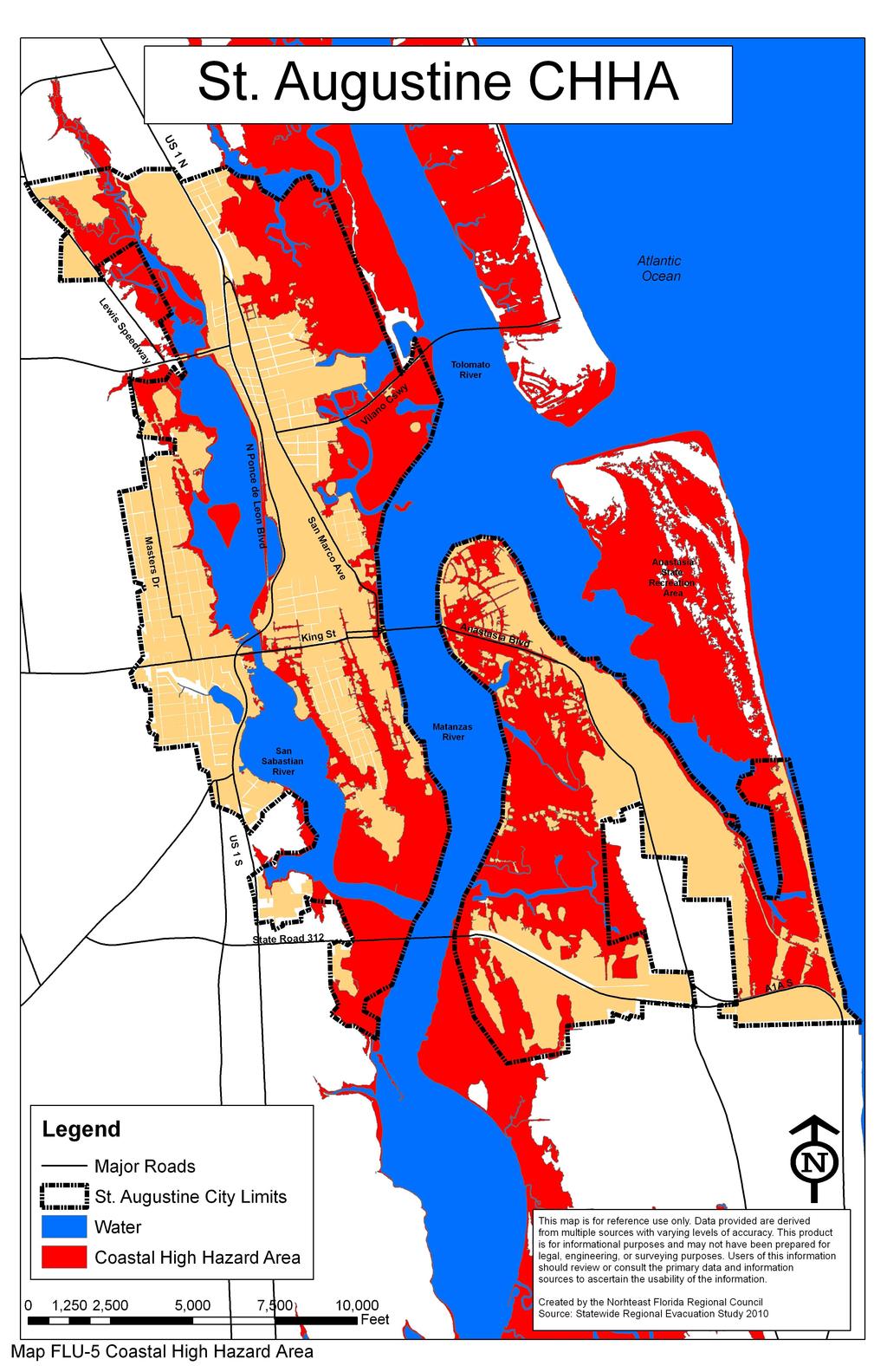
11 Low Density/Mixed Use, Residential Medium Density, Residential Medium Density/Mixed Use, Commercial Low Intensity and Commercial Medium Intensity land use classifications where the intent is to create mixes of uses. Continue to allow commercial uses within each sector to serve the residential districts within each sector. Close proximity of commercial service areas encourages pedestrian activity, and also serves the needs of special groups that do not readily have access to transportation facilities. In addition to promoting walkability, the city should coordinate with the Jacksonville Transportation Authority regarding the location of Park and Ride facilities, and should promote transit-oriented development and other sustainable development practices. FLU Objective 5 The City shall ensure the protection of natural resources as indicated in detail in the Goals, Objectives and Policies section of the Conservation and Coastal Management Element. The measurable target for this objective is the number of development proposals for development in a conservation overlay zone reviewed as required by the City's development regulations. FLU Objective 6 The City shall ensure that coastal area population densities are coordinated with the St. Johns County and the Northeast Florida Regional Statewide Regional Evacuation Study Program. This objective is implemented by FLU Policy The measurable target for this objective is land use classifications in the coastal high hazard areas established by the Northeast Florida Regional Hurricane Evacuation Study, which may be revised periodically to reflect best available data. FLU Policy 6.1 The City shall use the following land use classifications in the coastal high hazard areas as depicted in the Coastal High Hazard Area Map adopted as part of the Future Land Use Map Series for future land use map amendments and annexations: Residential Low Density, Residential Low Density/Mixed Use, Public/Semi-public, Recreation/Open Space and Open Land. Future Land Use Element 11
12 FLU Objective 7 The City will act to discourage the proliferation of urban sprawl. The measurable targets for this objective are: (1) review of proposed annexations according to the requirements of Chapter 171 Florida Statutes; (2) approval of large scale land use plan amendments by the Department of Community Affairs; (3) approval of small scale land use plan amendments as required by Rule 9J-5 and Chapter 163 Florida Statutes; and (4) the continued enforcement of City development regulations which implement this objective. FLU Policy 7.1 Annexations will be reviewed according to the requirements contained in Chapter 171 Florida Statutes. This policy implements FLU Objective 11. FLU Policy 7.2 The City will continue to enforce the City Code which requires developers to connect to the city's sanitary sewer system if. The City shall pursue the elimination of all septic tanks within the City and the City s sewer service area by the year FLU Policy 7.3 Encourage, through a graduated fee schedule for water and wastewater connections, new development or redevelopment in areas where adequate transportation and public utilities exist or are already planned. By developing in areas where utilities are existing, developers are not required to pay line extension costs for utilities. FLU Policy 7.4 Public facilities and utilities shall be located to maximize the efficiency of services provided, minimize their cost, and minimize their impacts on the natural environment by locating public facilities on land having the appropriate land use classification for the proposed use. FLU Policy 7.5 Future extension of City roads shall promote compact and contiguous patterns of development. FLU Policy 7.6 The City will continue to make provision for innovative techniques such as Planned Unit Developments (PUD), zero lot line development and cluster housing through the rezoning process established in the City Code, and by allowing condominium types of ownership for both residential and commercial development. FLU Objective 8 Continue to monitor the needs of the public utility systems and provide land for utilities facilities as necessary. The measurable target for this Future Land Use Element 12
13 objective is that the public utility system has the property required for needed facilities identified in the plan. FLU Policy 8.1 The City will maintain the existing 1,500 feet protective easements around the potable water well fields. FLU Policy 8.2 Maintain the adopted level of service standards for the service districts for sanitary sewer and potable water services. FLU Policy 8.3 The City shall maintain those lands presently allocated for public facilities or utilities with a Public/semi-public land use classification. Future Land Use Element 13
14
15
16
17
18
19
CHAPTER Committee Substitute for Committee Substitute for Senate Bill No. 2188
 CHAPTER 2004-372 Committee Substitute for Committee Substitute for Senate Bill No. 2188 An act relating to land development; amending s. 197.502, F.S.; providing for the issuance of an escheatment tax
REPORT OF THE PLANNING AND DEVELOPMENT DEPARTMENT FOR APPLICATION FOR REZONING ORDINANCE TO PLANNED UNIT DEVELOPMENT SEPTEMBER 22, 2016
 BEL REPORT OF THE PLANNING AND DEVELOPMENT DEPARTMENT FOR APPLICATION FOR REZONING ORDINANCE 2016-576 TO PLANNED UNIT DEVELOPMENT SEPTEMBER 22, 2016 The Planning and Development Department hereby forwards
1 Chapter 4 FUTURE LAND USE ELEMENT Section 4.1. Background information. 4.1.A. Land use profile. Indiantown possesses a unique and valuable mix of ph
 1 Chapter 4 FUTURE LAND USE ELEMENT Section 4.1. Background information. 4.1.A. Land use profile. Indiantown possesses a unique and valuable mix of physical and man-made resources centered on the Okeechobee
TREASURE COAST REGIONAL PLANNING COUNCIL M E M O R A N D U M
 TREASURE COAST REGIONAL PLANNING COUNCIL M E M O R A N D U M To: Council Members AGENDA ITEM 5F From: Date: Subject: Staff July 16, 2010 Council Meeting Local Government Comprehensive Plan Review Draft
REPORT OF THE PLANNING AND DEVELOPMENT DEPARTMENT FOR APPLICATION FOR REZONING ORDINANCE TO PLANNED UNIT DEVELOPMENT MAY 8, 2014
 BEL REPORT OF THE PLANNING AND DEVELOPMENT DEPARTMENT FOR APPLICATION FOR REZONING ORDINANCE TO PLANNED UNIT DEVELOPMENT MAY 8, 2014 The Planning and Development Department hereby forwards to the Planning
Required and optional elements of comprehensive plan; studies and surveys.
 163.3177 Required and optional elements of comprehensive plan; studies and surveys. (1) The comprehensive plan shall provide the consist of materials in such descriptive form, written or graphic, as may
PUTNAM COUNTYCOMPREHENSIVE PLAN
 COMPREHENSIVE PLAN EXHIBIT AA COMPREHENSIVE PLAN A. Future Land Use Element Goals, Objectives, Policies This section proposed objectives and policies, which will assist Putnam County Commissioners and
Midwest City, Oklahoma Zoning Ordinance
 2010 Midwest City, Oklahoma Zoning Ordinance 9/2/2010 Table of Contents Section 1. General Provisions... 5 1.1. Citation... 5 1.2. Authority... 5 1.3. Purpose... 5 1.4. Nature and Application... 5 1.5.
Future Land Use Element
 Summary of changes to the Goals, Objectives and Policies This element was updated to include the changes recommended in the 2006/2007 EAR and to reorganize the chapter to bring the land use classification
TOOELE COUNTY LAND USE ORDINANCE CHAPTER 31 Page 1
 CHAPTER 31 PLANNED COMMUNITY ZONE (P-C) Section 31-1 Definitions. 31-2 Purpose. 31-3 Land use districts. 31-4 P-C zone area minimum requirements. 31-5 Permitted uses. 31-6 Conditional uses. 31-7 Planning
HOUSING ELEMENT. 3. group and foster home construction. 1. increase the supply of new affordable housing with: a regional housing trust fund;
 Goal 8.0. Facilitate an adequate supply of decent, safe, and sanitary housing in suitable neighborhoods, including housing for special needs populations; available in a range of housing types, architectural
REPORT OF THE PLANNING AND DEVELOPMENT DEPARTMENT FOR APPLICATION FOR REZONING ORDINANCE TO PLANNED UNIT DEVELOPMENT MAY 18, 2017
 BEL REPORT OF THE PLANNING AND DEVELOPMENT DEPARTMENT FOR APPLICATION FOR REZONING ORDINANCE 2016-805 TO PLANNED UNIT DEVELOPMENT MAY 18, 2017 The Planning and Development Department hereby forwards to
SECTION 1 INTRODUCTION TO THE PANAMA CITY BEACH COMPREHENSIVE GROWTH DEVELOPMENT PLAN
 1. PURPOSE SECTION 1 INTRODUCTION TO THE PANAMA CITY BEACH COMPREHENSIVE GROWTH DEVELOPMENT PLAN The purpose of the City of Panama City Beach's Comprehensive Growth Development Plan is to establish goals,
Appendix A: Guide to Zoning Categories Prince George's County, Maryland
 Appendix A: Guide to Zoning Categories Prince George's County, Maryland RESIDENTIAL ZONES 1 Updated November 2010 R-O-S: Reserved Open Space - Provides for permanent maintenance of certain areas of land
BROWARD COUNTY LAND USE PLAN 2016 TEXT AMENDMENT PCT 16-6
 SECTION 2: POLICIES GENERAL BROWARD COUNTY LAND USE PLAN 2016 TEXT AMENDMENT PCT 16-6 POLICY 2.1.1 Broward County shall maintain a balanced Land Use Plan to implement a regional vision including the provision
Application to Amend the Bay County Zoning Map (Please type or print clearly)
") Application to Amend the Bay County Zoning Map (Please type or print clearly) File No.: Date Received: A) Applicant Information Owners Authorized name: agent: Mailing Mailing address: address: E-mail:
Application to Amend the Bay County Zoning Map (Please type or print clearly) File No.: Date Received: A) Applicant Information Owners Authorized name: agent: Mailing Mailing address: address: E-mail:
1. Future Land Use FLU6.6.8 Land uses within the Rural Service Area portion of the Wekiva Study Area shall be limited to very low and low intensity
 1. Future Land Use FLU6.6.8 Land uses within the Rural Service Area portion of the Wekiva Study Area shall be limited to very low and low intensity uses to the greatest extent possible. Existing land uses
SECTION 4 ZONING DISTRICTS
 SECTION 4 ZONING DISTRICTS Sec. 4-1 Establishment of Districts. In order to protect the character of existing neighborhoods, to prevent excessive density of population in areas which are not adequately
Nassau County Department of Planning & Economic Opportunity Nassau Place Yulee, Florida 32097
 Nassau County Department of Planning & Economic Opportunity 96161 Nassau Place Yulee, Florida 32097 APPLICATION AND INSTRUCTIONS FOR FUTURE LAND USE MAP AMENDMENT (TEN (10) ACRES OR MORE) NOTICE: Florida
CITY OF PORT ORCHARD
 CITY OF PORT ORCHARD ZONING DESIGNATIONS (Adapted from POMC Chapter 20.34 Zoning Districts, as adopted 6/13/2017) 20.34.110 Greenbelt zone (Gb). (1) Purpose. It is the purpose of the greenbelt zone to
The following regulations shall apply in the R-E District:
 "R-E" RESIDENTIAL ESTATE DISTRICT (8/06) The following regulations shall apply in the R-E District: 1. Uses Permitted: The following uses are permitted. A Zoning Certificate may be required as provided
TREASURE COAST REGIONAL PLANNING COUNCIL M E M O R A N D U M
 TREASURE COAST REGIONAL PLANNING COUNCIL M E M O R A N D U M To: Council Members AGENDA ITEM 6A From: Date: Subject: Staff May 20, 2011 Council Meeting Local Government Comprehensive Plan Review Draft
ARTICLE B ZONING DISTRICTS
 ARTICLE B ZONING DISTRICTS Sec. 8-3021 Established. In order to protect the character of existing neighborhoods; to prevent excessive density of population in areas which are not adequately served with
ORDINANCE NO:
 ORDINANCE NO: 2016-05 AN ORDINANCE OF THE CITY OF DAYTONA BEACH SHORES, VOLUSIA COUNTY FLORIDA, RELATING TO COMPREHENSIVE PLANNING; AMENDING THE CITY OF DAYTONA BEACH SHORES COMPREHENSIVE PLAN, AMENDING
Chapter 100 Planned Unit Development in Corvallis Urban Fringe
 100.100 Scope and Purpose. Chapter 100 Planned Unit Development in Corvallis Urban Fringe (1) All applications for land divisions in the Urban Residential (UR) and Flood Plain Agriculture (FPA) zones within
ARTICLE 14 PLANNED UNIT DEVELOPMENT (PUD) DISTRICT
 DISTRICT") ARTICLE 14 PLANNED UNIT DEVELOPMENT (PUD) DISTRICT Section 14.01 Intent. It is the intent of this Article to allow the use of the planned unit development (PUD) process, as authorized by the Michigan Zoning
ARTICLE 14 PLANNED UNIT DEVELOPMENT (PUD) DISTRICT Section 14.01 Intent. It is the intent of this Article to allow the use of the planned unit development (PUD) process, as authorized by the Michigan Zoning
Town of Yucca Valley GENERAL PLAN 1
 Town of Yucca Valley GENERAL PLAN 1 This page intentionally left blank. 3 HOUSING ELEMENT The Housing Element is intended to guide residential development and preservation consistent with the overall values
City File ZM th Street North St. Petersburg, FL Central Avenue, Suite 1600 St. Petersburg, FL 33701
 Staff Report to the St. Petersburg Community Planning & Preservation Commission Prepared by the Planning & Development Services Department, Urban Planning and Historic Preservation Division For Public
Future Land Use Element
 Vision Statement: Continue Coral Gables vision and mission as a community that is attractive to live, work, play and visit. Goals, Objectives and Policies: Goal FLU-1. Protect, strengthen, and enhance
HOUSING ELEMENT GOALS, OBJECTIVES, AND POLICIES
 HOUSING ELEMENT GOALS, OBJECTIVES, AND POLICIES GOAL 1: To promote the preservation and development of high-quality, balanced, and diverse housing options for persons of all income levels throughout the
LEE COUNTY, FLORIDA DEPARTMENT OF COMMUNITY DEVELOPMENT ZONING DIVISION STAFF REPORT. A. Applicant: Ronald Principato/ Principato Accessory Apartment
 LEE COUNTY, FLORIDA DEPARTMENT OF COMMUNITY DEVELOPMENT ZONING DIVISION STAFF REPORT TYPE OF CASE: CASE NUMBER: SPECIAL EXCEPTION SEZ2010-00002 HEARING EXAMINER DATE: JUNE 30, 2010 I. APPLICATION SUMMARY:
FRESHWATER WETLANDS PROTECTION IN NEW JERSEY Tools for Municipal Action
 FRESHWATER WETLANDS PROTECTION IN NEW JERSEY Tools for Municipal Action The Freshwater Wetlands Protection Act INTENT OF FRESHWATER WETLANDS LAW The New Jersey legislature passed the Freshwater Wetlands
Marion County Board of County Commissioners
 Marion County Board of County Commissioners Date: 6/4/217 P&Z: 9/25/217 BCC Transmittal: 1/17/217 BCC Adopt: TBD Amendment No: 217-L6 Type of Application Large-Scale Comp Plan Amendment Request: Change
City of Largo, FL: Comprehensive Development Code Chapter 5: Land Use Classifications
 Section 5.1 Land Use Classification System 5.1.1 Relationship to State Growth Management Requirements Chapter 163 of the Florida Statutes provides enabling legislation for local governments to ensure that
City of Coral Gables Planning and Zoning Staff Report
 City of Coral Gables Planning and Zoning Staff Report Applicant: Application: Public Hearing: Date & Time: Location: City of Coral Gables Giralda Restaurant Row Overlay Zoning Code Text Amendment Planning
ZONING CLASSIFICATION SUMMARY SHEET
 Growth and Resource Management Planning and Development Services 123 West Indiana Avenue Room 202 DeLand, Florida 32720-4253 Telephone (386) 943-7059 Fax (386) 626-6570 www.volusia.org ZONING CLASSIFICATION
Plans shall be drawn at a readable scale, signed, and sealed by a Florida Registered Engineer. The application package shall include:
 CHAPTER 400. SECTION 403. PERMIT TYPES AND APPLICATIONS SITE DEVELOPMENT 403.3. Preliminary Site Plans (PSP) A. Intent and Purpose PSPs are used to identify existing site conditions and demonstrate general
HOUSING ELEMENT GOALS, OBJECTIVES, & POLICIES
 HOUSING ELEMENT GOALS, OBJECTIVES, & POLICIES GOAL H-1: ENSURE THE PROVISION OF SAFE, AFFORDABLE, AND ADEQUATE HOUSING FOR ALL CURRENT AND FUTURE RESIDENTS OF WALTON COUNTY. Objective H-1.1: Develop a
Salem Township Zoning Ordinance Page 50-1 ARTICLE 50.0: PUD PLANNED UNIT DEVELOPMENT
 Salem Township Zoning Ordinance Page 50-1 ARTICLE 50.0 PLANNED UNIT DEVELOPMENT Section 50.01 Purpose The provisions of this Article provide enabling authority and standards for the submission, review,
ATTACHMENT #1 SUMMARY CHART
 ATTACHMENT #1 SUMMARY CHART Item # Amendment To: Nature of Proposed Amendment PCM201801 PCM201802 PCM201803 PCM201804 LMA201802 LMA201803 LMA201804 PCT201801 PCT201802 PCT201803 FUTURE LAND USE MAP Parkway
REPORT OF THE PLANNING AND DEVELOPMENT DEPARTMENT FOR APPLICATION FOR REZONING ORDINANCE TO PLANNED UNIT DEVELOPMENT AUGUST 20, 2015
 BEL REPORT OF THE PLANNING AND DEVELOPMENT DEPARTMENT FOR APPLICATION FOR REZONING ORDINANCE TO PLANNED UNIT DEVELOPMENT AUGUST 20, 2015 The Planning and Development Department hereby forwards to the Planning
ARTICLE XXI GENERAL SITE DEVELOPMENT PLAN REQUIREMENTS
 1 2 3 4 5 6 7 8 9 10 11 12 13 14 15 16 17 18 19 20 21 22 23 24 25 ARTICLE XXI GENERAL SITE DEVELOPMENT PLAN REQUIREMENTS Section 21.1 Purpose and Intent... 2 Section 21.2 Administrative Site Plan Review
GADSDEN COUNTY COMPREHENSIVE PLAN
 GADSDEN COUNTY COMPREHENSIVE PLAN 2015-2025 GADSDEN COUNTY BOARD OF COUNTY COMMISSIONERS Eric Hinson, District 1 Anthony O. Viegbesie, Phd., District 2 Gene Morgan, District 3 Brenda A. Holt, District
CITY OF PALM BEACH GARDENS CITY COUNCIL Agenda Cover Memorandum Meeting Date: November 1, 2018 Ordinance 24, 2018 / *Ordinance 25, 2018
 CITY OF PALM BEACH GARDENS CITY COUNCIL Agenda Cover Memorandum Meeting Date: November 1, 2018 Subject/Agenda Item: 11940 U.S. Highway One Small-Scale Comprehensive Plan Future Land Use Map Amendment and
TAMARAC, FLORIDA LAND DEVELOPMENT CODE. ADOPTION DRAFT July 2018 DRAFT
 TAMARAC, FLORIDA LAND DEVELOPMENT CODE ADOPTION July 2018 Chapter 10: Table of Contents Article 1. General Provisions... 1 10-1.1 Title... 1 10-1.2 Effective Date... 1 10-1.3 Authority... 1 10-1.4 Purpose...
Nassau County 2030 Comprehensive Plan. Future Land Use Element (FL) Goals, Objectives and Policies. Goal
 Goals, Objectives and Policies. Goal") (FL) Goal Effectively manage growth by encouraging and accommodating land uses which create a sound revenue base and offer diverse opportunities for a wide variety of living, working, shopping, and leisure
(FL) Goal Effectively manage growth by encouraging and accommodating land uses which create a sound revenue base and offer diverse opportunities for a wide variety of living, working, shopping, and leisure
Be linked by an internal circulation system (i.e., walkways, streets, etc.) to other structures within the IPUD;
 to other structures within the IPUD;") 2. HALIFAX ACTIVITY CENTER A. DESCRIPTIONS OF FUTURE LAND USE DESIGNATIONS Each of the future land use designations specified by Phase I of the Halifax Activity Center Plan, and the relationship of these
2. HALIFAX ACTIVITY CENTER A. DESCRIPTIONS OF FUTURE LAND USE DESIGNATIONS Each of the future land use designations specified by Phase I of the Halifax Activity Center Plan, and the relationship of these
BY BOARD OF COUNTY COMMISSIONERS AN ACT TO BE ENTITLED
 BY BOARD OF COUNTY COMMISSIONERS ORDINANCE NO. AN ACT TO BE ENTITLED AN ORDINANCE AMENDING THE PASCO COUNTY LAND DEVELOPMENT CODE, ARTICLE 700, BY REPEALING EXISTING SECTION 702, ENVIRONMENTALLY SENSITIVE
MEMORANDUM. Douglas Hutchens, Interim City Manag~ August 4, 2016 / Greg Rice, Director of Planning & Development
 Agenda Item: Meeting Date: PH-1 8/18/16 TO: THROUGH: DATE: FROM: SUBJECT: PRESENTER: RECOMMENDATION: BUDGET IMP ACT: PAST ACTION: NEXT ACTION: ATTACHMENTS: BACKGROUND: City Commission MEMORANDUM Douglas
Chapter 10: Implementation
 Chapter 10: Introduction Once the Comprehensive Plan has been adopted by the City of Oakdale, the City can begin to implement the goals and strategies to make this vision a reality. This chapter will set
TREASURE COAST REGIONAL PLANNING COUNCIL M E M O R A N D U M. To: Regional Planning Council Members AGENDA ITEM 5D
 TREASURE COAST REGIONAL PLANNING COUNCIL M E M O R A N D U M To: Regional Planning Council Members AGENDA ITEM 5D From: Date: Subject: Staff March 20, 2009 Regional Planning Council Meeting Local Government
CHAPTER 10 Planned Unit Development Zoning Districts
 CHAPTER 10 Planned Unit Development Zoning Districts Section 10.1 Intent and Purpose The Planned Unit Development (PUD) districts are intended to offer design flexibility for projects that further the
PINELLAS COUNTY COMPREHENSIVE PLAN
 PINELLAS COUNTY COMPREHENSIVE PLAN Future Land Use Map (FLUM) Category Descriptions and Rules Amended March 17, 2009 (Ordinance 09-17) Amended March 16, 2010 (Ordinance 10-18) Amended October 26, 2010
City of South Miami Comprehensive Plan
 City of South Miami Comprehensive Plan The City Commission of the City of South Miami, Florida adopted the Comprehensive Plan on January 18, 1989 for submittal to the Florida Department of Community Affairs
ARTICLE 15 - PLANNED UNIT DEVELOPMENT
 Section 15.1 - Intent. ARTICLE 15 - PLANNED UNIT DEVELOPMENT A PUD, or Planned Unit Development, is not a District per se, but rather a set of standards that may be applied to a development type. The Planned
INTRODUCTION Future Land Use Element
 EXHIBIT A INTRODUCTION Future Land Use Element The purpose of the Future Land Use Element is to examine the existing land uses and to determine present and future land use needs such as the amount of land
MARION COUNTY COMPREHENSIVE PLAN 2035
 FUTURE LAND USE ELEMENT APPENDIX A This Appendix A functions as a support to the Future Land Use Goals, Objectives and Policies. Each section within this Appendix serves as a regulatory policy in the Marion
SECTION 16. "PUD" PLANNED UNIT DEVELOPMENT OVERLAY DISTRICT
 SECTION 6. "PUD" PLANNED UNIT DEVELOPMENT OVERLAY DISTRICT Subsection. Purpose. This district is established to achieve the coordinated integration of land parcels and large commercial and retail establishments
Comprehensive Plan /24/01
 IV The is a central component of the Comprehensive Plan. It is an extension of the general goals and policies of the community, as well as a reflection of previous development decisions and the physical
ARTICLE 9: VESTING DETERMINATION, NONCONFORMITIES AND VARIANCES. Article History 2 SECTION 9.01 PURPOSE 3
 ARTICLE 9 VESTING DETERMINATIONS, NONCONFORMITIES, AND VARIANCES Table of Contents Article History 2 SECTION 9.01 PURPOSE 3 SECTION 9.02 LOT OF RECORD AND VESTING DETERMINATIONS FOR NONCONFORMING DEVELOPMENTS
EVALUATION AND APPRAISAL REPORT OF THE CITY OF FELLSMERE COMPREHENSIVE PLAN APPENDIX D HOUSING ELEMENT
 OBJECTIVE H-A-1: ALLOW AFFORDABLE HOUSING AND ADEQUATE SITES FOR VERY LOW, LOW, AND MODERATE INCOME HOUSING. The City projects the total need for very low, low, and moderate income-housing units for the
The Countywide Rules. Amended through May 31, 2016
 The Countywide Rules Amended through May 31, 2016 The Countywide Rules This document prepared and maintained by in its capacity as the Pinellas Planning Council 310 Court Street Clearwater, Florida 33756-5137
MEMORANDUM. Critical Areas Ordinance Density Requirements
 COUNTY COMMISSIONERS Creating Solutions for Our Future Cathy Wolfe District One Sandra Romero District Two Karen Valenzuela District Three PLANNING DEPARTMENT Scott Clark Director MEMORANDUM TO: FROM:
 PROJECT NARRATIVE AVENIR PCD MISCELLANEOUS AMENDMENT November 27, 2018 Urban Planning and Design Landscape Architecture Communication Graphics Request Avenir Development, LLC and Avenir Holdings, LLC,
ADUs and You! Common types of ADUs include mother-in-law suite, garage apartments and finished basements.
 ADUs and You! Accessory Dwelling Units Town of Lyons Accessory Dwelling Units (ADUs) are a form of housing that can be an important tool for diversifying and increasing the local housing stock. Lyons lost
City of Coral Gables Planning and Zoning Staff Report
 City of Coral Gables Planning and Zoning Staff Report Applicant: Application: Public Hearing: Date & Time: Location: City of Coral Gables Zoning Code Text Amendment Giralda Plaza Overlay District Planning
HOUSING ELEMENT OF THE CITY OF PEMBROKE PINES COMPREHENSIVE PLAN ADOPTION DOCUMENT
 HOUSING ELEMENT OF THE CITY OF PEMBROKE PINES COMPREHENSIVE PLAN RULES 9J-5.010, FAC City of Pembroke Pines, Florida ADOPTION DOCUMENT HOUSING ELEMENT HOUSING ELEMENT ADOPTION DOCUMENT VI. GOALS, OBJECTIVES
ARTICLE 1 Development Code Applicability
 CITY OF GRASS VALLEY MUNICIPAL CODE - TITLE 17 - DEVELOPMENT CODE ARTICLE 1 Development Code Applicability Chapter 17.10 - Purpose and Applicability of Development Code... 1-3 17.10.010 - Purposes of the
Nassau County 2030 Comprehensive Plan. Housing Element (H) Goals, Objectives and Policies. Goal
 Goals, Objectives and Policies. Goal") (H) Goal Assist the private sector to provide and maintain an adequate inventory of decent, safe and sanitary housing in suitable neighborhoods at affordable costs to meet the need of the present and future
(H) Goal Assist the private sector to provide and maintain an adequate inventory of decent, safe and sanitary housing in suitable neighborhoods at affordable costs to meet the need of the present and future
Chapter 1107: Zoning Districts
 Chapter 1107: Zoning Districts 1107.01 Establishment of Zoning Districts (a) Districts Established In order to carry out the purpose of this code, the City is hereby divided into the zoning districts established
TALLAHASSEE-LEON COUNTY 2030 COMPREHENSIVE PLAN
 TALLAHASSEE-LEON COUNTY 2030 COMPREHENSIVE PLAN The Tallahassee-Leon County Comprehensive Plan was adopted on July 16, 1990. The plan horizon for the Tallahassee-Leon County Comprehensive Plan is 2030.
ORDINANCE NOW THEREFORE, BE IT ENACTED BY THE CITY COMMISSION OF THE CITY OF WINTER GARDEN, FLORIDA, AS FOLLOWS:
 ORDINANCE 12-02 AN ORDINANCE OF THE CITY OF WINTER GARDEN, FLORIDA, AMENDING ARTICLE V OF CHAPTER 118 OF THE WINTER GARDEN CODE OF ORDINANCES ENTITLED PLANNED UNIT DEVELOPMENTS CREATING URBAN VILLAGE PLANNED
5.03 Type III (Quasi-Judicial) Decisions
 Decisions") 5.03 Type III (Quasi-Judicial) Decisions 5.03 General Requirements A. The purpose of this Section is to identify what types of actions are considered Type III decisions. Type III decisions involve significant
5.03 Type III (Quasi-Judicial) Decisions 5.03 General Requirements A. The purpose of this Section is to identify what types of actions are considered Type III decisions. Type III decisions involve significant
Gadsden County Planning Commission Agenda Report
 Gadsden County Planning Commission Agenda Report Date of Meeting: June 16, 2016 To: From: Subject: Honorable Chairperson and Members of the Planning Commission Allara Mills Gutcher, AICP, Planning & Community
DIVISION 1 PURPOSE OF DISTRICTS
 ARTICLE 2 ZONING DISTRICTS AND MAP DIVISION 1 PURPOSE OF DISTRICTS Section 2.101 Zoning Districts. For the purpose of this Ordinance, the City of Richmond is hereby divided into districts as follows: DISTRICT
REPORT OF THE PLANNING AND DEVELOPMENT DEPARTMENT FOR APPLICATION FOR REZONING ORDINANCE TO PLANNED UNIT DEVELOPMENT APRIL 21, 2016
 BEL REPORT OF THE PLANNING AND DEVELOPMENT DEPARTMENT FOR APPLICATION FOR REZONING ORDINANCE TO PLANNED UNIT DEVELOPMENT APRIL 21, 2016 The Planning and Development Department hereby forwards to the Planning
CHAPTER 14 PLANNED UNIT DEVELOPMENTS
 9-14-1 9-14-1 CHAPTER 14 PLANNED UNIT DEVELOPMENTS SECTION: 9-14-1: Purpose 9-14-2: Governing Provisions 9-14-3: Minimum Area 9-14-4: Uses Permitted 9-14-5: Common Open Space 9-14-6: Utility Requirements
Rule 80. Preservation of Primary Agricultural Soils Revised and approved by the Land Use Panel during its public meeting on January 31, 2006.
 Rule 80. Preservation of Primary Agricultural Soils Revised and approved by the Land Use Panel during its public meeting on January 31, 2006. (A) Purpose. In accordance with 10 V.S.A. Sections 6025(b)
FUTURE LAND USE ELEMENT PLAN IMPLEMENTATION REQUIREMENTS
 PLAN IMPLEMENTATION REQUIREMENTS I. INTRODUCTION The describes the appropriate location for future land uses and promulgates the policies regulating the location and development of all land uses. It also
Chapter Planned Residential Development Overlay
 Chapter 19.29 Planned Residential Development Overlay Sections 010 Purpose 020 Scope 030 Definitions 030 Minimum Size 040 Allowable Uses 050 Minimum Development Standards 060 Density Bonus 070 Open Space
APPLICATION REVIEW CHECKLISTS
 APPLICATION REVIEW CHECKLISTS The following must be submitted with and are part of each application. No application is complete until all required documentation has been submitted to the Community Development
PALM BEACH COUNTY PLANNING, ZONING AND BUILDING DEPARTMENT ZONING DIVISION
 PALM BEACH COUNTY PLANNING, ZONING AND BUILDING DEPARTMENT ZONING DIVISION Application No.: Z-2014-01627 Application Name: Dazco Center Control No.: 2003-00040 Applicant: 4730 Hypoluxo LLC Owners: 4730
SENATE, No STATE OF NEW JERSEY. 217th LEGISLATURE INTRODUCED SEPTEMBER 8, 2016
 SENATE, No. 0 STATE OF NEW JERSEY th LEGISLATURE INTRODUCED SEPTEMBER, 0 Sponsored by: Senator BOB SMITH District (Middlesex and Somerset) Senator CHRISTOPHER "KIP" BATEMAN District (Hunterdon, Mercer,
4. facilitate the construction of streets, utilities and public services in a more economical and efficient manner;
 PVPC MODEL BYLAW BY-RIGHT CLUSTER ZONING BYLAW Prepared by Pioneer Valley Planning Commission Revised: October 2001 1.00 Development 1.01 Development Allowed By Right Development in accordance with this
b. providing adequate sites for new residential development
 DIVISION 2.200 SECTION 2.201 INTRODUCTION A. Purpose The purpose of the Housing Element is to establish the goal, objectives, and policies to guide housing development within Polk County over the next
PLANNED UNIT DEVELOPMENT (PUD)
") SECTION 38.01. ARTICLE 38 PLANNED UNIT DEVELOPMENT (PUD) Purpose The purpose of this Article is to implement the provisions of the Michigan Zoning Enabling Act, Public Act 110 of 2006, as amended, authorizing
SECTION 38.01. ARTICLE 38 PLANNED UNIT DEVELOPMENT (PUD) Purpose The purpose of this Article is to implement the provisions of the Michigan Zoning Enabling Act, Public Act 110 of 2006, as amended, authorizing
3.1. OBJECTIVES FOR RESIDENTIAL LAND USE DESIGNATIONS GENERAL OBJECTIVES FOR ALL RESIDENTIAL DESIGNATIONS
 3. RESIDENTIAL LAND USE DESIGNATIONS INTRODUCTION The Residential land use designations provide for housing and other land uses that are integral to, and supportive of, a residential environment. Housing
City of Sanibel. Planning Department STAFF REPORT
 City of Sanibel Planning Department STAFF REPORT Planning Commission Meeting: July 23, 2013 Planning Commission Agenda Item: No 7b. Application Number: 13-7438DP Applicant Name: Attorney Beverly Grady
INDIAN RIVER COUNTY, FLORIDA. The Honorable Members of the Planning and Zoning Commission DEPARTMENT HEAD CONCURRENCE
 Public Hearing Legislative INDIAN RIVER COUNTY, FLORIDA M E M O R A N D U M TO: The Honorable Members of the Planning and Zoning Commission DEPARTMENT HEAD CONCURRENCE Robert M. Keating, AICP; Community
Article 7: Residential Land Use and Development Requirements
 Article 7: Residential Land Use and Section 701: Statement of Intent (A) (B) (C) The intent of Article 7 is to develop certain land use and development requirements for the residential uses within Cumru
AN ORDINANCE AMENDING AND SUPPLEMENTING THE REVISED GENERAL ORDINANCES OF THE CITY OF BAYONNE THE, CHAPTER 33 PLANNING AND DEVELOPMENT REGULATIONS
 AN ORDINANCE AMENDING AND SUPPLEMENTING THE REVISED GENERAL ORDINANCES OF THE CITY OF BAYONNE THE, CHAPTER 33 PLANNING AND DEVELOPMENT REGULATIONS WHEREAS, pursuant to N.J.S.A. 40:48-2, the Legislature
U-HAUL OF ORLANDO AN NEXATION
 September 18, 2018 Staff Report to the Municipal Planning Board A N X 2 0 1 8-10004 G M P 2 0 1 8-1 0 0 1 4, Z O N 2 0 1 8-10007 I T E M # 1 U-HAUL OF ORLANDO AN NEXATION Location Map S U M M A R Y Applicant
Title 6 - Local Government Provisions Applicable to Special Purpose Districts and Other Political Subdivisions
 Title 6 - Local Government Provisions Applicable to Special Purpose Districts and Other Political Subdivisions CHAPTER 29. SOUTH CAROLINA LOCAL GOVERNMENT COMPREHENSIVE PLANNING ENABLING ACT OF 1994 1994
(b) The location of principal and accessory buildings on the lot and the relationship of each structure to the other.
 The location of principal and accessory buildings on the lot and the relationship of each structure to the other.") ARTICLE XIX SITE PLAN Sec. 20-1900 Site Plan Review Procedure - Intent The site plan review procedures are instituted to provide an opportunity for the Township Planning Commission to review the proposed
ARTICLE XIX SITE PLAN Sec. 20-1900 Site Plan Review Procedure - Intent The site plan review procedures are instituted to provide an opportunity for the Township Planning Commission to review the proposed
REZONING APPLICATION INSTRUCTIONS
 REZONING APPLICATION INSTRUCTIONS All required information, as stated on the Rezoning Application Checklist, must be included to qualify as a complete application. Upon receipt, staff will review the application
EXHIBIT D. WRITTEN DESCRIPTION For. TOWNSEND VILLAGE PUD December 23, 2015 (Revised)
") I. PROJECT DESCRIPTION EXHIBIT D WRITTEN DESCRIPTION For TOWNSEND VILLAGE PUD December 23, 2015 (Revised) A. This 7.2 acre single-family residential project is located on the East side of Townsend Boulevard,
I. PROJECT DESCRIPTION EXHIBIT D WRITTEN DESCRIPTION For TOWNSEND VILLAGE PUD December 23, 2015 (Revised) A. This 7.2 acre single-family residential project is located on the East side of Townsend Boulevard,
2. LAND USE DESIGNATIONS AND PRINCIPLES FOR DEVELOPMENT
 2. LAND USE DESIGNATIONS AND PRINCIPLES FOR DEVELOPMENT General areas have been designated for specific types of land use on the Future Land Use Map and are described in this section. In order to satisfy
General Index. General Index
 General Index A aesthetics... iv, v, 1, 4, 8, 45, 91, 105, 146, 181, 293, 302 agreements developer s binding... 169, 176, 209, 262, 267, 272, 281, 282, 293 interlocal...164, 165, 249 water and sewer...
IRS FORM 8283 SUPPLEMENTAL STATEMENT DONATION OF CONSERVATION EASEMENT
 Name(s) shown on income tax return Identifying Number Robert T. Landowner 021-34-1234 Susan B. Landowner 083-23-5555 IRS FORM 8283 SUPPLEMENTAL STATEMENT DONATION OF CONSERVATION EASEMENT On November 12,
PALM BEACH COUNTY PLANNING, ZONING AND BUILDING DEPARTMENT ZONING DIVISION
 PALM BEACH COUNTY PLANNING, ZONING AND BUILDING DEPARTMENT ZONING DIVISION Application No.: CA-2012-00688 Control No.: 2011-00552 Applicant: Garry Bernardo Owners: Garry Bernardo Agent: Frogner Consulting,