OFFICIAL AGENDA PLANNING & ZONING COMMISSION CITY OF STARKVILLE, MISSISSIPPI
|
|
|
- Winfred Marsh
- 5 years ago
- Views:
Transcription
1 OFFICIAL AGENDA PLANNING & ZONING COMMISSION CITY OF STARKVILLE, MISSISSIPPI MEETING OF TUESDAY, March 11, 2014 CITY HALL - COURT ROOM, 101 E. LAMPKIN STREET, 5:30 PM I. CALL TO ORDER II. III. IV. PLEDGE OF ALLEGIANCE AND MOMENT OF SILENCE ROLL CALL CONSIDERATION OF THE OFFICIAL AGENDA V. CONSIDERATION FOR APPROVAL OF THE JANUARY 14, 2014 MINUTES VI. VII. VIII. CITIZEN COMMENTS OLD BUSINESS NEW BUSINESS A. RZ 13-08: Rezoning request by the Catholic Diocese of Jackson to Rezone properties located at or near 102 North Nash Street or Lots 16, 17, and 18 of Block 28 from R-1 Single Family to B-1 Buffer District. B. RZ 14-02: Rezoning request by the Cottages at Starkville Station, LLC to Rezone 4.03 acres at the end of R.V. Way from R-5 Multi-Family High Density to R-4A Single Family High Density. C. PP 14-01: Request for Preliminary Plat approval of a 22-lot, 4.03 acre single family subdivision. IX. PLANNER REPORT X. ADJOURN The City of Starkville is accessible to persons with disabilities. Please call the ADA Coordinator, Mr. Joyner Williams, at (662) , ext. 121 at least forty-eight (48) hours in advance for any services requested.
2 UNAPPROVED MINUTES OF THE PLANNING & ZONING COMMISSION MEETING OF JANUARY 14, 2014 THE CITY OF STARKVILLE, MISSISSIPPI The Planning & Zoning Commission of the City of Starkville, Mississippi, held its regularly scheduled meeting in the City Hall Courtroom at 101 E. Lampkin Street, Starkville, Mississippi, commencing at 5:30 PM. The meeting was called to order by Commission Chair Jerry Emison. Present were Commissioners Michael Brooks, Jerry Emison, Dora Herring, James Hicks, Ira Loveless, John Moore, and Jeremy Murdock. Attending the Commissioners were City Attorney Chris Latimer, City Planner Buddy Sanders, CAO Taylor Adams, and Recording Secretary Bill Green. A CONSIDERATION OF THE WRITTEN AGENDA The Commission considered the matter of approval of the written agenda dated January 14, Upon the motion of Commissioner Hicks, which was seconded by Commissioner Moore, the Commission voted unanimously to approve the written agenda as presented. CITIZEN COMMENTS Chair Emison asked if any member of the public cared to address the Commission, reminding them of the Public Hearing on the Agenda and that comments regarding proposed items would be called for at the appropriate time. No citizen comments were received. NEW BUSINESS RZ 13-14: Request by Garden Properties, LLC, to rezone 4.97 acres, parcel 102H , from R-1 Single Family to R-3A Single Family Medium Density; Ward 4. Chair Emison asked the City Planner to introduce item RZ 13-14, a Public Hearing noticed by the City of Starkville to rezone 4.97 acres, parcel 102H , from R-1 Single Family to R-3A Single Family Medium Density; Ward 4. City Planner Buddy Sanders stated that the Applicant is requesting to rezone 4.97 acres from R-1 Single Family to R-3A Single Family Medium Density to allow for garden homes to be constructed. Under the City of Starkville s Code of Ordinances Permitted and Conditional Use Chart in Appendix A, Article VIII, Section M, a single-family detached dwelling is listed as a permitted use in an R-3A zoning district. The minimum lot area allowed in an R-3A zone is 5,000 Page 1 of 9
3 square feet, which would allow for construction of garden homes. The subject area is currently an open field; to the north and east, properties are zoned R-1 Single Family and are single family/residential in use. Properties to the south and west are zoned R-1 Single Family but are civic in use, with Starkville High School s athletic facilities allowed as a Conditional Use, and to the north of Yellow Jacket Drive are C-2 zoning districts, a storage unit business in a B-1 Buffer District, and multi-family housing in an R-3 Multi-Family Zone. In order for a zoning change in Mississippi to occur, one of two criteria has to apply: Manifest Error in the Zoning Map or Change in Condition. No mapping errors exist in the proposed zone, and Mr. Sanders presented a historical series of zoning maps to illustrate zoning changes in the vicinity of the subject property. The subject property, along with adjacent properties to the east, south, and west, is classified as R- 1 in the , 2000, 2012, and 2013 zoning maps. The zoning changes to the north and along Yellow Jacket Drive are illustrated on the following maps: Zoning Map: R Zoning Map: R Zoning Map: R-3, B-1 & C Zoning Map: R-3, B-1 & C-2 Electrical, water, and sewer lines are available in the area. Access for the property is off Yellow Jacket Drive, which is classified as a collector street. Staff is unaware of any environmental issues at the site. There would be an increase in property tax revenue due to the increase in property value over the current use due to the creation of multiple single family homes. Temporary jobs would be created from construction of a proposed development. Any development proposal for the subject property would be required to conform to the City s land development regulations and would require review by the City s Development Review Committee prior to the commencement of any construction activities. The proposed Rezoning would allow additional housing options for Starkville and would be an infill development, which is supported by the Starkville Comprehensive Plan. The Applicant has submitted a market analysis illustrating the need for a new garden home community in Starkville. Community Development has received s and calls concerning the proposed Rezoning to R- 3A, with most of the communications being against the proposed Rezoning. The Pleasant Acres neighborhood is concerned that an adjacent garden home development would negatively affect their area, which is a traditional neighborhood in an R-1 zoning district. Community Development has received four s against the proposed zoning change. Staff has received one in favor of the zoning change to R-3A. Mr. Clinton Graves of 812 Pine Circle and Ms. Betty Templeton of 800 Lindley Avenue called Community Development and stated that they were against the Rezoning request by Garden Properties, LLC. Page 2 of 9
4 Staff recommends, based on the above findings, approval of the requested zoning change from R- 1 Single Family to R-3A Single Family Medium Density of 4.97 acres with the following conditions: 1) A Type B buffer yard (20 feet wide, 80 planting units per 100 feet) will be required, with the exception of the entrance area from Yellow Jacket Drive to the south property line of 102H ) All restrictive covenants in Deed Book 2008, page 6800, will be required. Chair Emison asked for clarification on whether the restrictive covenants in the Staff s conditions of approval would be made an enforceable responsibility of the City. Mr. Latimer stated that he would further research and verify in the interim (between the meetings of the Planning & Zoning Commission and the Board of Aldermen), whether the privity of covenants solely belonged to the landowners and successors of the landowners who made the agreement. Mr. Latimer requested a precise record showing the parcels that changed from R-3 to C-2 and R- 1 to B-1 so that the Commission could make an informed decision regarding evidence of change in the neighborhood. Mr. Sanders provided maps that illustrated that the only evidence of change happened in two properties that changed from R-3 to C-2 in 2007 and from R-1 to B-1 somewhere between 2000 and 2007 (due to a filing issue, Staff is unable to provide the exact date at this time). Commissioner Herring noted that since the 20-foot setback could count as the required 20-foot buffer, there would essentially be no buffer because the back yard would be the 20-foot buffer and that the only real requirement is the planting of trees in the back yard. Commissioner Loveless noted that in an from one of the neighbors in Pleasant Acres, an existing sewer drainage problem was mentioned, and he asked if the proposed development would tie in to the problematic one in Pleasant Acres. Mr. Sanders redirected the response to be answered by proper Staff. Mr. Murdock inquired about the number of maximum units per acre for an R-3A and was given the response by Mr. Sanders of eight units per acre. A discussion ensued about the number of units for the subject property, and it was determined that the report s information of 39 units is in error. Further discussion determined (with Dr. Herring s input reminding the Commission that after taking out the buffer, the roads, the retention, and common area, and making a calculation based on what is left), the subject property could be divided into not more than 24 units. Commissioner Herring noted that Table 32 of the comprehensive plan, where the amount of units per acre in an R-3 is referenced, should have read per usable land for lots per acre. Mr. Murdock suggested that at some point the wording be cleaned up. Mr. Emison stated that the Commission should base its decision on what is currently on the books. After no further questions by Commissioners, Chair Emison opened the Public Hearing. Page 3 of 9
5 The first citizen to speak was John Moore, a local attorney representing Garden Properties, LLC, owners of record and developers of the property. Mr. Moore stated that zoning map changes are not the only reflection of change in the area, and urged the Commission to notice the actual changes in the area, as well, when determining a verdict on rezoning, and mentioned that the closer one gets to Hwy 12, the more logical the trend is toward higher density, indicated by overall activity in the area. He suggested that when reviewing changes in the vicinity, a broader area beyond what actually touches Pleasant Acres should be considered. Regarding traffic, he stated that there has been an 800-car reduction in traffic due to another cut-through road, Yellow Jacket Extended, so 23 additional homeowners would not affect current flow adversely. Also, a covenant was omitted from the City Planner s report, which stated that no rentals would be allowed, and he asked to add it to the conditions of the report. Mr. Moore noted that only four lots of Pleasant Acres would back up to the proposed development and would have nominal impact on the neighborhood. Out of the 94 residents, 45 have less square footage than the 1500-square-foot minimum requirement of the subject property. The average assessed value of homes in Pleasant Acres is 117 thousand, compared to 190 thousand for the subject property. Regarding the Pleasant Acres residents petition against the development, Mr. Moore noted the following inaccuracies: 1) The petition states that the proposed development is for multi-family units; the homes to be developed are single family; and 2) The rezoning change affects Pleasant Acres; the rezoning request is not to rezone Pleasant Acres. He asked the Board to incorporate the report and consider the rezoning request. Commissioner Herring noted that the sample comparable garden homes listed in the report included homes with garages and buried lines and that most all were 100 percent brick. In 3-A homes, there are no such requirements and, thus, are not comparable. The second citizen to speak was Robert Boyd, who delivered petitions from Pleasant Acres residents stating their opposition to the proposed zoning change, citing the following reasons for their dissent: 1) Increase in traffic; 2) Decrease in property value; 3) Lack of evidence for demand for R-3A; and 4) Lack of Sidewalks, which should be required. Mr. Boyd stated that the Pleasant Acres residents request denial of the proposed zoning change, because the rezoning requirements haven t been met. The third citizen to speak was Thomas Bourgeois, who voiced his opposition to the proposed zoning change. The fourth citizen to voice a complaint was Kristin Dechert, who gave the following as her rebuttal to Mr. John Moore: Page 4 of 9
6 1) If a broad scope regarding change in surrounding area is being considered as a basis for a decision to rezone, then the same broader scope must also be extended in considering that more than the four bordering properties would be affected by the proposed rezoning; 2) Today s values can t be compared to 1950s prices; 3) The garden homes listed as comparables are zoned R-1; and 4) Public Need can t be cited as a reason for developing the property as R-3A, because a nearby property zoned as such has not yet been developed. She also stated that she is not against medium-density housing, but when a medium density zone is placed in the middle of a very large area of low density, stipulations need to be placed on such development, such as enforcing restrictive covenants already in place, as well as the buffering restrictions, so that the potential for uncertainties can be reduced. She requested a denial of the proposed rezoning to maintain the stability of the area. The fifth citizen was Clinton Graves, who maintained that he was contesting only the change in zoning, not the development of the property. The following are his reasons for opposition: 1) Increased density would affect the school, as well as the subdivision; 2) Howard Drive would potentially be used as a through drive, which would affect the value of the property in this highly desirable neighborhood. He also mentioned that the school board voted to oppose the change in density in the neighborhood, because of the hazardous situation created by the increase in traffic. The sixth citizen was Marty Haug, who voiced his opposition to the development, stating that the neighborhood is not Highway 12 and that the adjacent area shouldn t be zoned as such. The seventh citizen was Craig Piper, who requested that the Board consider the residents living in Pleasant Acres, and that the area was zoned R-1 for a reason. The eighth citizen to speak was Abby Poe, who opposed based on her concern for future residents of the garden homes in the R-3A zone, because they would be without a sufficient yard; therefore, their needs wouldn t be met. The ninth citizen to voice opposition was John Gaskin, whose concern was for the added burden of sewer and traffic upon the already distressed infrastructure created by the higher-density zone. He suggested that smart development is needed. Chair Emison asked for others to respond, and since there were none, he called for the Applicant to have an opportunity to respond. Mr. Moore responded on two points: 1) The undeveloped property hasn t been developed by choice, not by lack of demand; and 2) The property values of Pleasant Acres will not decrease because of a higher-value property adjoining the neighborhood. Value hasn t been decreased by Sherwood Commons and the hundreds of apartments on South Montgomery. Page 5 of 9
7 At the conclusion of Mr. Moore s response, Chair Emison closed the Public Hearing and opened deliberation from the Commission. He introduced the deliberation by stating that a certain set of findings needed to be met in order to go forward with a rezoning: 1) Error in Mapping (of which no error has been found); or 2) Change in Conditions and Public Need. City Attorney Latimer clarified that the burden of proof by the Applicant is a clear and convincing evidentiary standard, which is more than a preponderance of evidence (50 percent plus one), but less than beyond all reasonable doubt. Mr. Latimer clarified four points in the consideration of rezoning: 1) The Applicant has advised that a broad view of the word neighborhood needs to be taken into consideration, and the neighborhood has advised a narrow view. Legally, both views are acceptable and are at the Commission s discretion to avail; 2) How far back to look for change in neighborhood is also within the Commission s discretion, lawfully; 3) The law is clear that both past rezonings (buffer district and the Mexican restaurant) can be evidence of Change in Conditions, as well as contextual changes (changes that are visibly evident); and 4) The City has complied with state statute and ordinance by giving requisite notice. In regard to making a decision based on Change in Conditions, Chair Emison queried whether once a property s rezoning request had been denied by a previous board, if further changes in condition have to occur for approval. Mr. Latimer answered in the affirmative, but that since this is a different proposal from a different applicant, an argument could be made that this rule doesn t apply. Mr. Loveless queried whether LLCs are considered a transparent entity or pass-through entity, i.e., the people of the LLC are actually the owners as opposed to the legal entity of an LLC, and City Attorney Latimer answered that the law is protective of LLCs, and to prove that an entity is a sham or pass-through entity would be difficult. Commissioner Herring stated that the duty of the Commission is to protect and preserve neighborhoods. The express purpose of the Comprehensive Plan is to protect older neighborhoods in particular. Acknowledging positive comments from Mr. Moore, she voiced concern with doubling the density in that area. She stated that the success of a garden home neighborhood is the aesthetic of garages and 100 percent brick homes with buried utilities; the absence of these qualities associated with the R-3A properties proposed would create a cluttered look. The density and the abovementioned affects the land use. Chair Emison raised concern about the potential for spot zoning and the possibility of a ripple effect emanating from this one spot and that from a planning standpoint, creating an unnecessarily Page 6 of 9
8 heterogeneous situation is undesirable. He expressed his difficulty in reaching the threshold of finding change in the neighborhood. Commissioner Herring commented that in the past, because of safety reasons, the Board has been reluctant to rezone in situations where access is limited, such as in this case, with only one means of ingress/egress. Commissioner Murdock remarked that no matter what standard of area is to be considered, in this specific case the area is small and not enough change exists to justify rezoning based on Change in Conditions. Chair Emison called for more discussion, and as there was none, Commissioner Murdock moved to deny the rezoning request based on lack of Change in Conditions, with Commissioner Herring seconding the motion. The motion to recommend denial of changing the zone from R-1 to R-3A passed 5-1, with Commissioner Moore voting no. After the vote, Chair Emison called for a fiveminute recess. PP 13-07: Request by Cottages at Starkville Station, LLC, for approval of a 22 lot Preliminary Plat for the Cottages at Starkville Station in an R-5 Zone; Ward 4. After the recess, Chair Emison called the meeting to reconvene, and City Planner Buddy Sanders presented the next item of New Business, a request by Cottages at Starkville Station, LLC, for approval of a 22 lot Preliminary Plat for the Cottages at Starkville Station in an R-5 Zone; Ward 4. All the requirements for property in an R-5 zone have been met. The tax parcels and city map show the area as right-of-way, but it was vacated by the City by deed in All the property is owned by the Applicant. Mr. Sanders noted that before the issue has reached the final Plat stage, because of an existing gas line, the Applicant would need a waiver for the 20-foot buffer yard required on the north side by the landscape ordinance for the abutment of two or more areas of different density uses. Chair Emison asked about the location of the road access, and he noted that four years ago, when the issue came up about rezoning what is now the RV Park, he had voiced concerns about the traffic on Lincoln Green Road, which still holds true in this situation, as well. Backup will occur because of capacity. Mr. Sanders stated that Engineering had reviewed the traffic and voiced no concern about the traffic flow. Mr. Loveless concurred that traffic is already backed, and to negotiate the turn from Lincoln Green Road onto Blackjack is challenging. After discussing possible traffic options, Chair Emison stated that public interest would be sacrificed because of the traffic. Commissioner Herring observed that in an R-5 zone, the lots are required to be 50 feet wide if the development is for single-family dwellings of less than 8 units, whereas the plat states the lots are 38 feet wide. Page 7 of 9
9 Mr. Latimer informed the Commission of the following options from the Commission s Ordinance on Preliminary Plat Approval: 1) The Commission can recommend approval; or 2) The Board can recommend approval only if certain conditions are met. If approval is recommended with certain conditions, it is incumbent on the Commission to state the conditions and to state the reasons for them, and can require the Applicant to bring back the plat incorporating those conditions to be reviewed again at a preliminary stage; or 3) The Board can recommend disapproval and state reasons why the action was recommended for disapproval and, if possible, make recommendations for how the plat can be approved. If the Board makes a recommendation for disapproval, the Applicant has two options: 1) The Applicant can return the plat to the Commission, having amended the plat with the Commission s recommendations; or 2) The Applicant can go straight to the Board of Aldermen, despite having received a recommendation for disapproval. After discussion about the definition of the phrase 8 unit, single-family dwelling, Chair Emison recommended that the Applicant meet with Staff to work out any ambiguity of meaning of the phrase. Since the plat presently contemplates a layout that conflicts with the City s minimum lot requirements, and any approval of the plat by the Commission would be in violation of the City s regulations, the Applicant withdrew the plat request in favor of returning to the Commission at a later time. Commissioner Hicks requested that the vicinity map street names be in a bigger font. Chair Emison asked for consideration of the installation of a right-turn-only island construct at the corner of RV Way and Lincoln Green Road. Commissioner Hicks reminded the Commission that consideration needs to be taken for the RVs that require extra room for navigating the turn. Chair Emison suggested a traffic light be installed. After the discussion, the Applicant officially withdrew the plat approval. CONSIDERATION FOR APPROVAL OF THE MINUTES OF THE MEETING OF DECEMBER 10, 2013 Chair Emison called for consideration for approval of the December 10, 2013, minutes. Mr. Latimer suggested the following change to the minutes: On the last paragraph of the first page, second line, to change the word requested to noticed. Commissioner Herring moved to approve the minutes as amended, seconded by Commissioner Loveless, and the resulting vote for accepting the minutes as revised was unanimous. Chair Emison Page 8 of 9
10 asked to be on record as having recused himself from participating in any revisions of the minutes that might concern the Mill at MSU. PLANNER S REPORT City Planner Buddy Sanders reported that regarding proceeding with the zoning change for the Research Park, he and Mr. Adams will be meeting with Joey Deason, COO of Golden Triangle Development Link. Representatives who operate businesses inside the park will be contacted to apprise them of recent developments. A letter will go out to MSU, OCEDA, TVA, and C Spire, giving them time to contact us beforehand; and after 30 days, appropriate steps will be taken to proceed with the rezoning. Commissioner Herring asked whether all the properties were being considered for rezoning, and Mr. Sanders responded that all the properties except for the condominiums, 300 Traditions, were being considered for rezoning to Planned Office. ADJOURNMENT Commissioner Emison called for a motion to adjourn. Commissioner Murdock made the motion, seconded by Commissioner Hicks, and the Commission voted unanimously to adjourn the meeting at 8:11 PM. The next regularly scheduled meeting will be Tuesday, February 11, 2014, at 5:30 PM in the City Hall Courtroom. Jerry Emison, Chair Buddy Sanders, City Planner Page 9 of 9
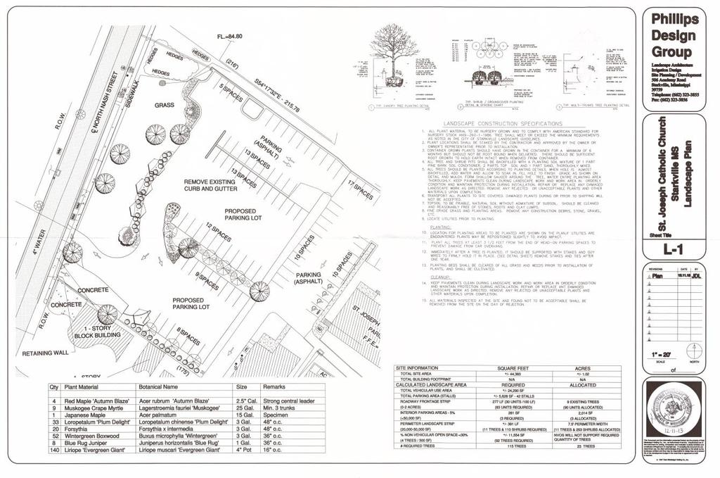
11 THE CITY OF STARKVILLE COMMUNITY DEVELOPMENT DEPT CITY HALL, 101 E. LAMPKIN STREET STARKVILLE, MISSISSIPPI ST AFF REPORT TO: Members of the Planning & Zoning Commission FROM: Buddy Sanders ( ext. 119) CC: Catholic Diocese of Jackson, Applicant SUBJECT: RZ 13-08: Rezoning request for property located at or near 102 North Nash Street or Lots 16, 17 and 18 of Block 28 DATE: February 7, 2014 BACKGROUND: The applicant s request came before the Planning & Zoning Commission at the July 24, 2013, Special Call meeting. During the hearing, neighbors in the Nash Street area expressed concerns pertaining to storm-water runoff and traffic. Questions came up regarding the number of parking spaces, number of cars at church services/events, gravel, landscaping, and site design. The Catholic Diocese of Jackson s request for a Rezoning was tabled until additional information could be provided. Since the July 24, 2013, hearing, the applicant has submitted a site plan/landscape plan illustrating 29 parking spaces and required landscaping. Please see Attachment 4. The applicant also submitted storm water documents. Please see Attachment 5. NOTIFICATION: Notification by mail to adjacent property owners within 300 feet of the subject parcels took place on January 24, 2014, and a notification sign was also placed on North Nash Street. An ad was placed and published in the January 27, 2014, Starkville Daily News. AREA: The subject property is located north of the intersection of North Nash Street and University Drive, or more specifically, Lots 16, 17, and 18 of Block 28, City of Starkville (highlighted in blue on Attachment 1). Currently the properties are vacant, but single-family homes were once located on the subject lots. There is elevation difference between the lots, as well as along North Nash Street. Older growth trees are located on the properties (see Attachment 3). There are multiple zoning districts and uses, adjacent to the subject properties. Saint Joseph Catholic Church is located to the east, in a T-5 zoning district. Located to the south are a convenience store, rental unit(s), and offices facing University Drive, which are also in a T-5 zoning district. To the west are multi- and single-family uses in T-5, C-2, and R-3 zones. The property to the north is owned by the applicant and has a parking lot that was approved by Exception in 1994; it is zoned R-1.
12 The North Nash Street Historic District (which is highlighted in yellow on Attachments 1 and 2) is located to the west of the subject properties. Homes in this area were constructed during the 1930s and were the primary reason that North Nash Street was designated as a historic district. City zoning maps show the subject properties have been zoned R-1 Single Family since the 1970s with nearby properties being zoned C-2 General Business, R-3 Multi Family and R-1 Single Family. The T-5 District has been in existence since REZONING REQUEST: The Catholic Diocese of Jackson is requesting a zoning change from R-1 Single Family to B-1 Buffer District to allow the construction of a parking lot between St. Joseph Catholic Church and North Nash Street (see Attachment 1). Differences between R-1 and B-1 zones are: R-1 Single Family: These [R-1 residential] districts are intended to be composed mainly of Single-family residential properties along with appropriate neighborhood facilities, with their character protected by requiring certain minimum yard and area standards to be met. B-1 Buffer District: These [B-1 buffer] districts are intended to be composed mainly of compatible mixed commercial and residential uses. Although usually located between residential and commercial areas, these districts may in some instances be freestanding in residential areas. Limited commercial uses are permitted that can in this district be compatible with nearby residential uses. The character of the district is protected by requiring that certain yard and area requirements be met. STATE REZONING CRITERIA: Per Title 17, Chapter 1, of the Mississippi Code of 1972, as amended, and Appendix A, Article IV, Section A, of the City of Starkville Code of Ordinances, the Official Zoning Map may be amended only when one or more of the following conditions prevail: 1. Error: There is a Manifest Error in the ordinance and a Public Need to correct the error. There are no errors in need of correction with either the ordinance or zoning map. 2. Change in Conditions. Changed or changing conditions in an existing area, or in the planning area generally, or the increased or increasing need for commercial or manufacturing sites or additional subdivision of open land into urban building sites make a change in the ordinance necessary and desirable, and in accord with the public need for orderly and harmonious growth. Consistency with Comprehensive Plan. Page 8 of the Comprehensive Plan gives guidance to parking lot design, which the Applicant s plans meet: 2
13 Reduce the amount of impervious surface allowed in developments (adopt standards that encourage things like allowing narrower local streets, and encourage the use of permeable but stable parking areas). Encourage more, but smaller, parking lots. People generally will not walk more than 300 feet to a destination so these smaller lots would encourage more shoppers. Use landscaping liberally in between these smaller lots. Absolutely forbid clear cutting of trees and inappropriate land grading for development in non-agricultural areas. Restrict clearing to the minimum area needed for the building footprint, construction access and safety setbacks. Trees to be kept should be clearly marked. This reduces storm water management costs and adds to the value of the land. Page 45 of the Comprehensive Plan also expresses the need to protect Nash Street: Nash Street needs special attention, but not to improve the road to accommodate the traffic increases. This is a residential area that needs protection from additional traffic in the form of traffic calming devices or re-routing to divert traffic to other streets. Changes to internal streets on campus may assist in this effort. Right now, the route from College View Drive to Nash (and vice versa) and onto University Drive apparently saves drivers some time. Also, Nash connects Highway 182 with University and is a convenient cut-through. Although interconnectivity is generally a good thing, residential neighborhood streets should be spared becoming a collector or arterial at the expense of the safety and quality of life of the residents. Land Use Compatibility: A parking lot would be compatible with existing adjacent land uses. To the north is an existing parking lot that was approved by Special Exception in To the east is the St. Joseph Catholic Church. There are commercial and multi-family uses to the south and singleand multi-family uses to the west. Changed Conditions: The most recent change in the zoning classification is the creation of the T-5 zone in February 2013, which allowed higher density and mixed uses to the south and east of the subject properties. In addition, in 1994 a parking lot was approved by Exception and was constructed on the adjacent north property, therefore allowing the same use as what is proposed by the applicant for the subject properties. Adequate Public Facilities: Access to public streets is available, along with electrical, water and sewer lines. Natural Environment: There are several existing older and large canopy trees on the property, and the church property sits on a higher elevation than some of surrounding properties. In the last Public Hearing, supporting evidence was submitted of a water-runoff issue in the past along North Nash Street. The applicant has submitted documentation, Attachment 5, stating that the 3
14 amount of impervious surface materials will be less with the proposed parking lot, then when to preexisting homes were present on the subject lots. The City Engineering Staff has reviewed storm water and site plan information and has the following comments: It is suggested that the driveway entering the street be approximately 10 to 15 feet of concrete apron to prevent the gravel from the parking lot from entering the public roadway. It is suggested to either have turnarounds at the end of each dead end driveway or provide a north/south connector from each drive to allow for easier and safer exit in the instances where all the parking spaces on that aisle are full. Per the provided storm water calculations, the post development runoff volume for the twoand 10-year storm events is less than or equal to the predevelopment runoff volumes for those same storm events. Historically, the inlets located on Nash Street have had issues with flooding during heavy rain events. These inlets drain the water from Nash Street roadway, as well as a large majority of the Catholic church campus. It is suggested, if the Catholic church is agreeable, to provide an additional inlet and corresponding pipe, which would be located on the Catholic church property near the northwest corner of the site that will collect and convey the water from the Catholic church campus to the existing inlet and storm sewer instead of discharging this storm water into the roadway. Economic Effects: The proposed parking lot would be for a non-profit organization and would not have an effect of additional property taxes. Some jobs may be created from the construction of the proposed parking lot. Orderly Development: Any development proposal for the subject property would be required to conform to the City s land development regulations and would require review by the City s Development Review Committee prior to the commencement of any construction activities. Public Need: The construction of a parking lot would allow for additional off-street parking, creating a safer parking option. STAFF RECOMMENDATION: If the Planning and Zoning Commission decides to approve the applicant s Rezoning request from R-1 Single Family to B-1 Buffer, Staff recommends the following conditions: 1) North Nash Street traffic flow recommendations: a.) Access to parking lot from North Nash Street should be right-turn in only -or- b.) No access allowed from North Nash Street. 2) Existing trees should be preserved and proper measures should be used during and after construction to protect existing trees. 3) If property is ever developed, current trees on the subject properties shall not be cut. 4) Storm water runoff should be addressed to the satisfaction of the City Engineer. 4
15 Attachment 1 5

16 6
17 Attachment 2 7

18 8
19 Attachment 3 9


20 North View East View 10


21 South View West View 11

22 North Nash Street View (East) 12
23 Attachment 4 13
24 Attachment 5 14
25 15
26 16
27 17
28 18
29 19
30 20
31 21
32 22
33 23
34 24
35 25
36 26
37 27
38 THE CITY OF STARKVILLE COMMUNITY DEVELOPMENT DEPT CITY HALL, 101 E. LAMPKIN STREET STARKVILLE, MISSISSIPPI STAFF REPORT TO: Members of the Planning & Zoning Commission FROM: Buddy Sanders ( ext. 119) CC: Cottages at Starkville Station, LLC, Applicant SUBJECT: RZ 14-02: Rezoning request of 4.03 acres located west of the Starkville Station RV Park or at the end of R.V. Way. DATE: March 6, 2014 BACKGROUND/AREA: The applicant is seeking to Rezone 4.03 acres from R-5 Multi-Family High Density to R-4A Single Family High Density to allow for the construction of a 22-lot garden home community. Please see Attachment 4. The subject property is located west of the Starkville Station R.V. Park or at the end of R.V. Way. The applicant s property is vacant and once was a residential area. Please see Attachments 2 and 3. Hoover Drive and Shady Lane served as access for the area at one time, but the City issued a Release of Roadway Easement and Quit Claim Deed, for the two roads on April 23, 1998, Deed Book 956, page 336. A subdivision plat for the subject property was reviewed at the January 8, 2014 Planning and Zoning Commission meeting. Questions regarding the R-5 zoning district and lot width were discussed in the meeting, and the Preliminary Plat request was withdrawn by the applicant. The applicant has applied for the subject Rezoning for R-4A, to allow for a smaller lot width. The applicant has also submitted a revised Preliminary Plat, to meet the requirements of a R-4A development is on the Planning and Zoning Agenda for consideration. The earliest zoning map that staff has available illustrates the subject properties being R-2 Single Family. The 1982 zoning map lists the subject properties as being zoned R-5, which is the current zoning district today. Please see Attachments 1, 2, and 3. Zoning Change Subject Property: 1960s-1970s 1982 Map 2000 Map Current Map Map R-2 R-5 R-5 R-5
39 Zoning Change Adjacent Properties: Properties 1960s-1970s 1982 Map 2000 Map Current Map Map North C-2 C-2 C-2 C-2 East R-2 R-5 R-5 C-2 South R-2 R-5 R-5 R-5 West R-1 & R-2A R-1 & R-3 R-3 R-3 Adjacent Land Uses: Direction North East South West Use Commercial & Residential R.V. Park Apartments Condos NOTIFICATION: Notification by mail to adjacent property owners within 300 feet of the subject parcels took place on February 20, 2014, and a notification sign was also placed at the end of R.V. Way. An ad was placed and published in the February 24, 2014, Starkville Daily News. REZONING REQUEST: The subject rezoning requests are from R-5 Multi-Family High Density to R-4A Single Family High Density. Differences between R-5 and R-4A zones are: R-5 Multi-Family: These [R-5 residential] districts are intended to be composed mainly of multifamily dwellings, although a wide range of dwelling types is also permitted. Mobile homes, mobile home parks, and mobile home subdivisions are also permitted under certain special conditions. Appropriate supporting facilities to accommodate higher density multifamily districts are permitted and the character of this residential district is protected by requiring certain yard and area standards to be met. [The following regulations apply to R-5 districts:] 1. See chart for permitted uses. 2. See chart for uses which may be permitted as a special exception. 3. Required lot area and width, yards, building areas and height for residences: (a) Minimum lot area, per unit: 1,800 square feet. (b) Minimum lot width at building line: Single-family & multifamily dwelling of less than eight units: 50 Townhouse dwelling: 16 feet. Multifamily dwellings of eight units or more: 100 feet. (c) Minimum depth of front yard: 25 feet. 2
40 R-4A Multi-Family: Please see Attachment 7. (d) Minimum width of side yard: Five feet. (e) Minimum depth of rear yard: 20 feet. (f) Maximum height of structure: 45 feet. Mobile homes on individual lots shall comply with the provisions of article VII, section E. Mobile home parks and mobile home subdivisions shall comply with provisions of article VII, section H.4. Off-street parking requirements: See article VIII of this ordinance for requirements for other uses. Maximum density requirements for both R-5 and R-4 are the same, at 15 units per acre. The proposed gross density of the Cottages at Starkville Station project is 5.46 units per acre. STATE REZONING CRITERIA: Per Title 17, Chapter 1, of the Mississippi Code of 1972, as amended, and Appendix A, Article IV, Section A, of the City of Starkville Code of Ordinances, the Official Zoning Map may be amended only when one or more of the following conditions prevail: 1. Error: There is a Manifest Error in the ordinance and a Public Need to correct the error: There are no errors in need of correction with either the ordinance or zoning map. 2. Change in conditions. Changed or changing conditions in an existing area, or in the planning area generally, or the increased or increasing need for commercial or manufacturing sites or additional subdivision of open land into urban building sites make a change in the ordinance necessary and desirable, and in accord with the public need for orderly and harmonious growth. Consistency with Comprehensive Plan: The Starkville Comprehensive Plan supports infill development to achieve greater utilization of existing municipal service, reduce the need for cost of extension of services, and provide housing options. Please see Attachment 6. Land Use Compatibility: An R-4A development would be compatible with adjacent uses in that the proposed Cottages at Starkville Station single family units would mix well with existing single family residential areas to the north and the density of the proposed Cottages at Starkville Station development would fit with the Polo Apartments to the south and the Bella Grove Condominiums to the west yet would 3
41 be a medium density development, by having a 5.46 units per acre. A medium density development is 4-8 units per acre; high density is 8-15 units per acre. Changed Conditions: There has been a significant change at the intersection on South Montgomery Street and Yellow Jacket Drive since 2007 with the multi-family/condo developments of Annabella and Belle Grove to the west. Please see Attachment 5. The Starkville Station R.V. Park to the west was Rezoned from R-5 to C-2 in Please see above under Background/Area for zoning change information. Adequate Public Facilities: Water, sewer, and electrical lines are available. Properties have access to Lincoln Green Road by way of R.V. Way Please see below for Mississippi Department of Transportation Average Daily Traffic (ADT) totals two closest MDOT traffic count sites: SITE ID (Blackjack Road in front of The Hampton Inn) ADT ADT ADT ADT ADT ADT ADT ADT ADT ADT SITE ID (Blackjack Road behind the USDA Research Lab) ADT ADT ADT ADT ADT ADT ADT ADT ADT ADT
42 The City is considering making Lincoln Green Road one way going south. Natural Environment: There are no known environmental issues. A R-4A development requires 20% of the proposed development to be open space. The applicant is also proposing to have a bio retention area as part of the development. Buffer yards would be required on the east, west, and south property lines. The applicant is encouraged to seek a Waiver from the Tree Advisory Board for the buffer yard required along the north property line due to an underground gas transmission line. Economic Effects: Orderly Development: There would be an economic gain to the City of Starkville in the form of increased property tax revenue, sales tax revenue being spent at local merchants, and creation of jobs from temporary construction. Any development proposal for the subject property would be required to conform to the City s land development regulations and would require review by the City s Development Review Committee prior to the commencement of any construction activities. The Cottages at Starkville Station Preliminary Plat has been reviewed by the Development Review Committee. Public Need: The proposed Rezoning would allow additional housing options for Starkville and would be an infill development, what the Starkville Comprehensive Plan supports. STAFF RECOMMENDATION: If the Planning and Zoning Commission decides to approve the Applicant s Rezoning request from R-3 Multi-Family to C-1 Neighborhood Commercial, Staff recommends the following conditions: 1) The developer is to utilize bio-retention as a means of storm water management with a plan to be submitted to and approved by the City Planner and Engineer during the Development Review process. 2) A Waiver is required from the Starkville Tree Advisory Board for the required north buffer yard. 3) Development is limited to 22 lots for single family homes 5
43 Attachment 1 6

44 7
45 Attachment 2 8

46 9
47 Attachment 3 10

48 11
49 Attachment 4 12

50 13
51 Attachment 5 14
52 15
53 Attachment 6 16
54 17
55 18
56 19
57 Attachment 7 20
58 21
59 22
60 23

61 THE CITY OF STARKVILLE COMMUNITY DEVELOPMENT DEPT CITY HALL, 101 E. LAMPKIN STREET STARKVILLE, MISSISSIPPI STAFF REPORT TO: Members of the Planning & Zoning Commission FROM: Buddy Sanders City Planner ( ext. 119) CC: PP Cottages At Starkville Station, LLC DATE: March 7, 2014 BACKGROUND INFORMATION: Cottages at Starkville Station, LLC, is requesting Preliminary Plat approval of a 22 lot subdivision west of the Starkville Station RV Park. Please see Attachments 1 and 2. Zoning for the property is R-5 (Multi-Family, High-Density). A subdivision plat for the subject property was reviewed at the January 8, 2014 Planning and Zoning Commission meeting. Questions regarding the R-5 zoning district and lot width were discussed in the meeting, and the Preliminary Plat request was withdrawn by the applicant. The applicant has requested a Rezoning to R-4A to allow for a lot width less than 50 in width. Please see Attachment 3. There are no minimum lot size requirements in a R-4A zone. Conditions of a R-4A development are in Attachment 4. Please note that the areas illustrated as Right of Way in the PP Area Zoning and PP Aerial maps is not Public Right of Way. In 1998 the City issued a Release of Roadway Easement and Quit Claim Deed for both Hoover Drive and Shady Lane. Please see Attachment 5. PLAT PROPOSAL General Information The applicant is requesting Preliminary Plat approval of a 22 lot subdivision totaling 4.03 acres. Please see Attachment 4. Easements and Dedications The proposed lots will front an extension of RV Way and a new street to be named Station Lane. RV Way takes access off Lincoln Green Street. There is an existing 10-foot sewer/utility easement along the western property line and an existing gas/utility easement along the northern property line.
62 The applicant will have 10-foot utility easements fronting all new streets of the proposed subdivision, and electrical, water, and sewer services are available. Findings and Comments The Cottages at Starkville Station Preliminary Plat was reviewed by the Development Review Committee on December 19 and February 27. There are no significant concerns regarding the subject Preliminary Plat, but the Engineering Division did note that upstream storm water will need to be routed through the development in some fashion without it going through the detention facility and a slight adjustment in the turning radius at the end of R.V. Way. Three off-street parking spaces per lot is required of a R-4A development. In order to reduce the amount of impervious surface area, a pervious surface parking area, such as grasscrete, be used for at least the third parking space. CONCLUSIONS Staff recommends approval of the Cottages at Starkville Station Preliminary Plat. It is recommended that the following conditions be issued with recommendation of approval: 1. Additional easements may be required. 2. Upstream storm water will need to be routed through the development in some fashion without it going through the detention facility. 3. Infrastructure drawings will be required upon Preliminary Plat approval prior to construction. 4. Parking spaces are to illustrated and surface type listed. The third parking space per lot is to be pervious. 5. Rezoning approval to a R-4A Single Family High Density zoning district is required. 2
63 Attachment 1 3

64 4
65 Attachment 2 5
66 6
67 Attachment 3 7
68 8
69 Attachment 4 9
70 10
71 11
72 12
73 Attachment 5 13
74 14
75 15
A. Consideration of the unapproved December 8, 2015 minutes B. Consideration of the unapproved January 12, 2016 minutes
 OFFICIAL AGENDA PLANNING & ZONING COMMISSION CITY OF STARKVILLE, MISSISSIPPI MEETING OF TUESDAY, April 12, 2016 CITY HALL - COURT ROOM, 110 West Main Street, 5:30 PM I. CALL TO ORDER II. III. IV. PLEDGE
OFFICIAL AGENDA PLANNING & ZONING COMMISSION CITY OF STARKVILLE, MISSISSIPPI
 OFFICIAL AGENDA PLANNING & ZONING COMMISSION CITY OF STARKVILLE, MISSISSIPPI MEETING OF TUESDAY, JANUARY 14, 2013 CITY HALL - COURT ROOM, 101 E. LAMPKIN STREET, 5:30 PM I. CALL TO ORDER II. III. IV. PLEDGE
A. CONSIDERATION OF THE UNAPPROVED MINUTES OF NOVEMBER 13, 2018
 I. CALL TO ORDER OFFICIAL AGENDA PLANNING & ZONING COMMISSION CITY OF STARKVILLE, MISSISSIPPI MEETING OF TUESDAY, DECEMBER 11, 2018 1ST FLOOR CITY HALL COURT ROOM 110 WEST MAIN STREET AT 5:30 PM II. III.
A. CONSIDERATION OF THE UNAPPROVED MINUTES OF DECEMBER 11, 2018
 I. CALL TO ORDER OFFICIAL AGENDA PLANNING & ZONING COMMISSION CITY OF STARKVILLE, MISSISSIPPI MEETING OF TUESDAY, JANUARY 8, 2018 1ST FLOOR CITY HALL COURT ROOM 110 WEST MAIN STREET AT 5:30 PM II. III.
ZONING AMENDMENT, PLANNED UNIT DEVELOPMENT & SUBDIVISION STAFF REPORT Date: August 8, 2013
 ZONING AMENDMENT, PLANNED UNIT DEVELOPMENT & SUBDIVISION STAFF REPORT Date: August 8, 2013 NAME SUBDIVISION NAME PV-Magnolia, LLC Twelve Trees Subdivision LOCATION 2860, 2862 and 2866 Pleasant Valley Road
ZONING AMENDMENT & SUBDIVISION STAFF REPORT Date: July 9, 2015
 ZONING AMENDMENT & SUBDIVISION STAFF REPORT Date: July 9, 2015 APPLICANT NAME 2513 Dauphin Street, Inc. SUBDIVISION NAME Audubon Place Extension No. 3, Resubdivision of Lots 1-5 LOCATION 2513 Dauphin Street
ZONING AMENDMENT & SUBDIVISION STAFF REPORT Date: June 18, 2015
 ZONING AMENDMENT & SUBDIVISION STAFF REPORT Date: June 18, 2015 APPLICANT NAME SUBDIVISION NAME EAA LLC / Eryka Rogers Aaiden Place Subdivision LOCATION 2480 Government Boulevard (North side of Government
ZONING AMENDMENT & SUBDIVISION STAFF REPORT Date: March 1, 2018
 #13 SUB-000406-2018 & ZON-000407-2018 ZONING AMENDMENT & SUBDIVISION STAFF REPORT Date: March 1, 2018 NAME SUBDIVISION NAME LOCATION Creekside @ Kooiman Dairy Creekside @ Kooiman Dairy Subdivision (South
ZONING AMENDMENT, SUBDIVISION & SIDEWALK WAIVER REQUEST STAFF REPORT Date: November 16, 2006
 ZONING AMENDMENT, SUBDIVISION & SIDEWALK WAIVER REQUEST STAFF REPORT Date: November 16, 2006 NAME SUBDIVISION NAME Terhaar & Cronley Investment Partnership P & E Subdivision LOCATION 4210 and 4218 Halls
CITY OF ALBERT LEA PLANNING COMMISSION ADVISORY BOARD
 CITY OF ALBERT LEA PLANNING COMMISSION ADVISORY BOARD 9/1/2015, 5:30 p.m. City Council Chambers AGENDA A. CALL TO ORDER AND ROLL CALL B. APPROVAL OF THE AGENDA C. APPROVAL OF MINUTES 1. PC Minutes from
EDGERTON CITY HALL PLANNING COMMISSION MEETING REGULAR SESSION March 12, 2019
 EDGERTON CITY HALL PLANNING COMMISSION MEETING REGULAR SESSION The met in regular session with Chair John Daley calling the meeting to order at 7:00 p.m. All present participated in the Pledge of Allegiance.
CHAPTER 26 PLANNING AND ZONING ARTICLE VII. MOBILE HOMES AND RECREATIONAL VEHICLE (RV) PARKS. Recreational Vehicle (RV) Park Development Standards
 PARKS. Recreational Vehicle (RV) Park Development Standards") CHAPTER 26 PLANNING AND ZONING ARTICLE VII. MOBILE HOMES AND RECREATIONAL VEHICLE (RV) PARKS. Section 26-VII-1. Section 26-VII-2. Section 26-VII-3. Section 26-VII-4. Section 26-VII-5. Purpose Permitted
CHAPTER 26 PLANNING AND ZONING ARTICLE VII. MOBILE HOMES AND RECREATIONAL VEHICLE (RV) PARKS. Section 26-VII-1. Section 26-VII-2. Section 26-VII-3. Section 26-VII-4. Section 26-VII-5. Purpose Permitted
PLANNED UNIT DEVELOPMENT & SUBDIVISION STAFF REPORT Date: April 18, 2019
 PLANNED UNIT DEVELOPMENT & SUBDIVISION STAFF REPORT Date: April 18, 2019 DEVELOPMENT NAME SUBDIVISION NAME Springhill Village Subdivision Springhill Village Subdivision LOCATION 4350, 4354, 4356, 4358,
Town of Windham. Planning Department 8 School Road Windham, ME voice fax
 Town of Windham Planning Department 8 School Road Windham, ME 04062 voice 207.894.5960 fax 207.892.1916 MEMO DATE: September 3, 2013 TO: Tony Plante, Town Manager FROM: Ben Smith, Assistant Town Planner
A favorable recommendation to the City Council is requested.
 To: Sycamore Plan Commission From: Brian Gregory, City Manager Date: November 9, 2017 Re: November 13, 2017 Plan Commission Meeting The Plan Commission has one action item and three workshop items. I.
BOARD OF ADJUSTMENT MEETING CITY OF ST. PETE BEACH
 BOARD OF ADJUSTMENT MEETING CITY OF ST. PETE BEACH 155 Corey Avenue St. Pete Beach, Florida Wednesday, 11/15/2017 2:00 p.m. Call to Order Pledge of Allegiance Roll Call 1. Changes to the Agenda Agenda
THE AREA PLAN COMMISSION OF ST. JOSEPH COUNTY, IN AGENDA
 THE AREA PLAN COMMISSION OF ST. JOSEPH COUNTY, IN AGENDA Tuesday, June 20, 2017 Fourth-Floor Council Chambers 3:30 p.m. County-City Building, South Bend, IN PUBLIC HEARINGS: 1. Rezonings: A. A combined
SUBDIVISION, PLANNING APPROVAL, & REZONING STAFF REPORT Date: June 4, 2015
 SUBDIVISION, PLANNING APPROVAL, & REZONING STAFF REPORT Date: June 4, 2015 APPLICANT NAME SUBDIVISION NAME DEVELOPMENT NAME LOCATION Board of Water & Sewer Commissioners of the City of Mobile MAWSS MLK
SUBDIVISION, PLANNED UNIT DEVELOPMENT, ZONING AMENDMENT, & SIDEWALK WAIVER STAFF REPORT Date: July 19, 2018
 SUBDIVISION, PLANNED UNIT DEVELOPMENT, ZONING AMENDMENT, & SIDEWALK WAIVER STAFF REPORT Date: July 19, 2018 NAME SUBDIVISION NAME LOCATION West Mobile Properties, LLC U.S. Machine Subdivision 556, 566,
APPLICANT NAME SUBDIVISION NAME DEVELOPMENT NAME LOCATION. CITY COUNCIL DISTRICT Council District 4 PRESENT ZONING PROPOSED ZONING
 SUBDIVISION, PLANNED UNIT DEVELOPMENT, PLANNING APPROVAL, ZONING AMENDMENT, & SIDEWALK WAIVER REQUEST STAFF REPORT Date: February 17, 2010 APPLICANT NAME SUBDIVISION NAME DEVELOPMENT NAME LOCATION David
Town of Cary, North Carolina Rezoning Staff Report 14-REZ-31 Cary Park PDD Amendment (Waterford II) Town Council Meeting January 15, 2015
 Town Council Meeting January 15, 2015") Town of Cary, North Carolina Rezoning Staff Report 14-REZ-31 Cary Park PDD Amendment (Waterford II) Town Council Meeting January 15, 2015 REQUEST To amend the Town of Cary Official Zoning Map by amending
Town of Cary, North Carolina Rezoning Staff Report 14-REZ-31 Cary Park PDD Amendment (Waterford II) Town Council Meeting January 15, 2015 REQUEST To amend the Town of Cary Official Zoning Map by amending
Boise City Planning & Zoning Commission Minutes November 3, 2014 Page 1
 Page 1 PUD14-00020 / 2 NORTH HOMES, LLC Location: 2818 W. Madison Avenue CONDITIONAL USE PERMIT FOR A FOUR UNIT PLANNED RESIDENTIAL DEVELOPMENT ON 0.28 ACRES LOCATED AT 2818 & 2836 W. MADISON AVENUE IN
ZONING AMENDMENT & SUBDIVISION STAFF REPORT Date: November 3, 2016
 ZONING AMENDMENT & SUBDIVISION STAFF REPORT Date: November 3, 2016 APPLICANT NAME SUBDIVISION NAME David Shumer 5955 Airport Subdivision CITY COUNCIL DISTRICT District 6 5955 Airport Boulevard, 754 Linlen
City and Borough of Sitka Planning and Zoning Commission Minutes of Meeting. November 17, 2009
 City and Borough of Sitka Planning and Zoning Commission Minutes of Meeting Present: Don Alexander (Chairman), Richard Parmelee (Member), William Stortz (Member), Karen Dhillon (Member), Wells Williams
Town of Waxhaw Board of Commissioners. Waxhaw Police Department Community Meeting Room Tuesday January 12, 2016
 Town of Waxhaw Board of Commissioners Waxhaw Police Department Community Meeting Room Tuesday January 12, 2016 Petition RZ-003994-2015 A request by the Town of Waxhaw Planning & Community Development Department,
SUBDIVISION, PLANNED UNIT DEVELOPMENT, PLANNING APPROVAL, ZONING AMENDMENT, & SIDEWALK WAIVER REQUEST STAFF REPORT Date: February 17, 2010
 SUBDIVISION, PLANNED UNIT DEVELOPMENT, PLANNING APPROVAL, ZONING AMENDMENT, & SIDEWALK WAIVER REQUEST STAFF REPORT Date: February 17, 2010 APPLICANT NAME SUBDIVISION NAME DEVELOPMENT NAME LOCATION David
ZONING BOARD OF APPEALS MINUTES MAY 28, 2013
 ZONING BOARD OF APPEALS MINUTES MAY 28, 2013 The meeting was called to order by Acting Chairman Edward Kolar at 7:33 p.m. Board Members Gregory Constantino, Barbara Fried, Meg Maloney and John Micheli
MINUTES JOINT MEETING LINCOLN COUNTY and SIOUX FALLS PLANNING COMMISSIONS 7:00 pm July 14, 2010
 MINUTES JOINT MEETING LINCOLN COUNTY and SIOUX FALLS PLANNING COMMISSIONS 7:00 pm July 14, 2010 Commissioners Room - Lincoln County Court House A joint meeting of Lincoln County and Sioux Falls Planning
DEWITT CHARTER TOWNSHIP 1401 W. HERBISON ROAD, DeWITT, MI PLANNING COMMISSION MINUTES MONDAY, APRIL 7, 2008
 DEWITT CHARTER TOWNSHIP 1401 W. HERBISON ROAD, DeWITT, MI PLANNING COMMISSION MINUTES MONDAY, APRIL 7, 2008 The regularly scheduled meeting of the DeWitt Charter Township Planning Commission was called
PLANNING COMMISSION MINUTES - CITY OF INVER GROVE HEIGHTS. Tuesday, May 20, :00 p.m. City Hall Chambers Barbara Avenue
 PLANNING COMMISSION MINUTES - CITY OF INVER GROVE HEIGHTS Tuesday, 7:00 p.m. City Hall Chambers - 8150 Barbara Avenue Chair Hark called the Planning Commission meeting to order at 7:00 p.m. Commissioners
1. Roll Call. 2. Minutes a. September 26, 2016 Regular Meeting. 3. Adoption of the Agenda. 4. Visitors to Be Heard
 1. Roll Call City of Vermillion Planning Commission Agenda 5:30 p.m. Regular Meeting Tuesday, October 11, 2016 Large Conference Room 2 nd Floor City Hall 25 Center Street Vermillion, SD 57069 2. Minutes
RP-2, RP-3, RP-4, AND RP-5 PLANNED RESIDENTIAL DISTRICTS
 6.10 - RP-2, RP-3, RP-4, AND RP-5 PLANNED RESIDENTIAL DISTRICTS 6.10.1 GENERAL DESCRIPTION: 6.10.1.1 The regulations established in this Section are intended to provide optional methods of land development
ZONING AMENDMENT, PLANNED UNIT DEVELOPMENT & SUBDIVISION STAFF REPORT Date: March 5, 2009
 ZONING AMENDMENT, PLANNED UNIT DEVELOPMENT & SUBDIVISION STAFF REPORT Date: March 5, 2009 NAME SUBDIVISION NAME LOCATION Kentress Morrisette Booker T. Washington Highlands Subdivision, First Addition,
ZONING AMENDMENT, PLANNED UNIT DEVELOPMENT & PLANNING APPROVAL STAFF REPORT Date: June 7, 2007
 ZONING AMENDMENT, PLANNED UNIT DEVELOPMENT & PLANNING APPROVAL STAFF REPORT Date: June 7, 2007 NAME LOCATION Johnny Randall Cotton and Angela K. Cotton 4800 Tufts Road (West side of Tufts Road, 50 ± North
May 21, ACHD Board of Commissioners Stacey Yarrington, Planner II DRH /DRH
 Development Services Department May 21, 2013 TO: FROM: SUBJECT: ACHD Board of Commissioners Stacey Yarrington, Planner II DRH13-00106/DRH13-00108 Executive Summary: This is a design review application
WESTMINSTER PARK SUBDIVISION
 WESTMINSTER PARK SUBDIVISION Engineering Comments: FINAL PLAT COMMENTS (should be addressed prior to submitting the FINAL PLAT for review and/or signature by the City Engineer): A. Provide all of the required
ELK RAPIDS TOWNSHIP ANTRIM COUNTY, MICHIGAN ORDINANCE NO
 ELK RAPIDS TOWNSHIP ANTRIM COUNTY, MICHIGAN ORDINANCE NO. 3-2011 AN ORDINANCE TO REPLACE THE SUBDIVISION CONTROL ORDINANCE WITH A NEW SUBDIVISION DEVELOPMENT ORDINANCE, IN ACCORD WITH THE LAND DIVISION
TO: Glynn County Board of Commissioners. Eric Landon, Planner II. ZM2773 Peppertree Crossing Phase II
 COMMUNITY DEVELOPMENT DEPARTMENT Planning and Zoning Division 1725 Reynolds Street, Suite 200, Brunswick, GA 31520 Phone: 912-554-7428/Fax: 1-888-252-3726 TO: Glynn County Board of Commissioners MEMO FROM:
Village of Cazenovia Zoning Board of Appeals August 12, 2014
 Village of Cazenovia Zoning Board of Appeals August 12, 2014 FINAL - 1 - Village of Cazenovia Zoning Board of Appeals August 12, 2014 5 10 Members Present: Phil Byrnes, Chair; Sally Ryan; William Keiser;
Zoning Board of Appeals
 Zoning Board of Appeals Minutes (meeting taped) Monthly meeting: Thursday, July 15, 2010 in the City Hall Aldermanic Chambers. The meeting was called to order at 6:35 p.m. Without objection the chair called
ZONING AMENDMENT, PLANNED UNIT DEVELOPMENT & SUBDIVISION STAFF REPORT Date: September 15, 2011
 ZONING AMENDMENT, PLANNED UNIT DEVELOPMENT & SUBDIVISION STAFF REPORT Date: September 15, 2011 NAME SUBDIVISION NAME LOCATION Stratford, L.L.C. Grelot Office Park Subdivision North side of Grelot Road,
Midwest City, Oklahoma Zoning Ordinance
 2010 Midwest City, Oklahoma Zoning Ordinance 9/2/2010 Table of Contents Section 1. General Provisions... 5 1.1. Citation... 5 1.2. Authority... 5 1.3. Purpose... 5 1.4. Nature and Application... 5 1.5.
PLANNED UNIT DEVELOPMENT & SUBDIVISION STAFF REPORT Date: November 17, 2016
 PLANNED UNIT DEVELOPMENT & SUBDIVISION STAFF REPORT Date: November 17, 2016 DEVELOPMENT NAME SUBDIVISION NAME LOCATION Autonation Ford of Mobile Autonation Ford of Mobile Subdivision 901, 909, and 925
1. Cuyler-Brownsville planned neighborhood conservation (P-N-C) districtphase I (section ). (2) Single-family semiattached dwellings;
 districtphase I (section ). (2) Single-family semiattached dwellings;") Sec. 8-3035. Planned unit development multifamily (PUD-M). A. Purpose. The PUD-M district is intended to allow a variety of residential development including single-family residential, two-family residential,
Sec. 8-3035. Planned unit development multifamily (PUD-M). A. Purpose. The PUD-M district is intended to allow a variety of residential development including single-family residential, two-family residential,
Staff Report PLANNING DIVISION COMMUNITY & ECONOMIC DEVELOPMENT. Alley Closure
 Staff Report PLANNING DIVISION COMMUNITY & ECONOMIC DEVELOPMENT To: From: Salt Lake City Planning Commission Doug Dansie, 801-535-6182, doug.dansie@slcgov.com Date: March 23, 2016 Re: PLNPCM2015-00941
UPPER MOUNT BETHEL TOWNSHIP NORTHAMPTON COUNTY, PENNSYLVANIA
 UPPER MOUNT BETHEL TOWNSHIP NORTHAMPTON COUNTY, PENNSYLVANIA JOINDER DEED / LOT CONSOLIDATION TOWNSHIP REVIEW PROCESS When accepting proposed Joinder Deeds / Lot Consolidations, review the Joinder Deed
Committed to Service
 Committed to Service Paul Woods, President Rebecca W. Arnold, Vice President Sara M. Baker, Commissioner Jim D. Hansen, Commissioner Kent Goldthorpe, Commissioner August 25, 2017 Development Services TO:
ZONING AMENDMENT & SUBDIVISION STAFF REPORT Date: July 3, 2014
 ZONING AMENDMENT & SUBDIVISION STAFF REPORT Date: July 3, 2014 APPLICANT NAME SUBDIVISION NAME LOCATION Georgia Crown Distributing Subdivision Georgia Crown Distributing Subdivision Southwest corner of
PLANNED UNIT DEVELOPMENT & SUBDIVISION STAFF REPORT Date: July 20, 2017
 PLANNED UNIT DEVELOPMENT & SUBDIVISION STAFF REPORT Date: July 20, 2017 DEVELOPMENT NAME SUBDIVISION NAME LOCATION Rangeline Crossing III Subdivision Rangeline Crossing III Subdivision 5289 Halls Mill
TOWN OF MINNESOTT BEACH PLANNING BOARD MEETING August 6, 2009
 TOWN OF MINNESOTT BEACH PLANNING BOARD MEETING August 6, 2009 MEMBERS PRESENT: Tim Fowler, Buddy Belangia, Bill Schmidt, Dave Gaskins, and Mac Rubel via telephone. Valerie Calcavecchia arrived after the
Minutes of the Proceedings Laramie County Planning Commission Prepared by the Laramie County Planning & Development Office Laramie County Wyoming
 Minutes of the Proceedings Laramie County Planning Commission Prepared by the Laramie County Planning & Development Office Laramie County Wyoming Thursday, April 10, 2014 140410 00 The Laramie County Planning
M E M O R A N D U M. Meeting Date: April 19, Item No. H-2. Mark Hafner, City Manager. Michele Berry, Planner II
 M E M O R A N D U M Meeting Date: April 19, 2016 Item No. H-2 To: From: Subject: Mark Hafner, City Manager Michele Berry, Planner II PUBLIC HEARING: Consider an ordinance approving a Specific Use Permit
Community Dev. Coord./Deputy City Recorder
 1 2 3 4 5 6 7 8 9 10 11 12 13 14 15 16 17 18 19 20 21 22 23 24 25 26 27 28 29 30 31 32 33 34 35 36 37 38 39 40 41 42 43 44 45 46 NORTH OGDEN PLANNING COMMISSION MEETING MINUTES December 18, 2013 The North
Official Minutes of MARION COUNTY BOARD OF COUNTY COMMISSIONERS. December 20, 2017
 Official Minutes of MARION COUNTY BOARD OF COUNTY COMMISSIONERS December 20, 2017 CALL TO ORDER: The Marion County Board of County Commissioners met in a special session in Commission Chambers at 2:02
Planning Department Oconee County, Georgia
 Planning Department Oconee County, Georgia STAFF REPORT REZONE CASE #: 6985 DATE: October 31, 2016 STAFF REPORT BY: Andrew C. Stern, Planner APPLICANT NAME: Williams & Associates, Land Planners PC PROPERTY
Marion County Board of County Commissioners
 Marion County Board of County Commissioners Date: 12/29/2015 P&Z: 12/28/2015 BCC: 1/12/2016 Item Number 160113Z Type of Application Rezoning Request From: A-1 (General Agriculture) To: PUD (Planned Unit
PLANNING AND ZONING COMMISSION ZONE CHANGE
 PLANNING AND ZONING COMMISSION ZONE CHANGE DOÑA ANA COUNTY COMMUNITY DEVELOPMENT DEPARTMENT Doña Ana County Government Center 845 N. Motel Blvd. Las Cruces, New Mexico 88007 Telephone: (575) 647-7350 MEETING
9. REZONING NO Vicinity of the northwest corner of 143 rd Street and Metcalf Avenue
 9. REZONING NO. 2002-15 Vicinity of the northwest corner of 143 rd Street and Metcalf Avenue 1. APPLICANT: Andrew Schlagel is the applicant for this request. 2. REQUESTED ACTION: The applicant is requesting
CHAPTER 14 PLANNED UNIT DEVELOPMENTS
 9-14-1 9-14-1 CHAPTER 14 PLANNED UNIT DEVELOPMENTS SECTION: 9-14-1: Purpose 9-14-2: Governing Provisions 9-14-3: Minimum Area 9-14-4: Uses Permitted 9-14-5: Common Open Space 9-14-6: Utility Requirements
ARTICLE 15 - PLANNED UNIT DEVELOPMENT
 Section 15.1 - Intent. ARTICLE 15 - PLANNED UNIT DEVELOPMENT A PUD, or Planned Unit Development, is not a District per se, but rather a set of standards that may be applied to a development type. The Planned
Financial Impact Statement There are no immediate financial impacts associated with the adoption of this report.
 STAFF REPORT Planning and Development Department Subject: Application by RYC Property to rezone a portion of lands on John Murray Dr. and Megan Lynn Dr. from R2 to R3 and to enter into a Development Agreement
ORDINANCE NO. NOW, THEREFORE, BE IT ORDAINED BY THE CITY COUNCIL OF THE CITY OF BRYAN, TEXAS:
 LOCATION MAPS: ORDINANCE NO. AN ORDINANCE OF THE CITY OF BRYAN, TEXAS, AMENDING CHAPTER 130, ZONING, OF THE CITY OF BRYAN CODE OF ORDINANCES, BY CHANGING THE ZONING CLASSIFICATION FROM AGRICULTURAL - OPEN
DATE: February 28, Marilynn Lewis, Principal Planner
 DATE: February 28, 2007 TO: FROM: RE: Salt Lake City Planning Commission Marilynn Lewis, Principal Planner Planning Commission Hearing for Petition 400-06-41 Zoning Map Amendment to Rezone 6 Properties,
1. Roll Call. 2. Minutes a. September 24, 2018 Special Joint Meeting with Clay County Planning Commission. 3. Adoption of the Agenda
 1. Roll Call City of Vermillion Planning Commission Agenda 5:30 p.m. Regular Meeting Tuesday, October 9, 2018 City Council Chambers 2 nd Floor City Hall 25 Center Street Vermillion, SD 57069 2. Minutes
O-I (Office-Institutional) and AG-1(Agricultural)
 and AG-1(Agricultural)") PROPERTY INFORMATION ADDRESS 3503 and 3505 Bethany Bend DISTRICT, LAND LOTS 2/1 973 and 974 OVERLAY DISTRICT State Route 9 PETITION NUMBERS EXISTING ZONING O-I (Office-Institutional) and AG-1(Agricultural)
PROPERTY INFORMATION ADDRESS 3503 and 3505 Bethany Bend DISTRICT, LAND LOTS 2/1 973 and 974 OVERLAY DISTRICT State Route 9 PETITION NUMBERS EXISTING ZONING O-I (Office-Institutional) and AG-1(Agricultural)
Request from Chad DeWaard for a Special Land Use Permit to Operate a Home-Based Business on property located at Cascade Road SE
 LOWELL CHARTER TOWNSHIP PLANNING COMMISSION REGULAR MEETING AND PUBLIC HEARINGS PRESENT: Blough, Batchelor, Simmonds, Clements, Edwards TOWNSHIP PLANNER: Tim Johnson CITIZENS IN ATTENDANCE: 13 The Regular
KENT PLANNING COMMISSION BUSINESS MEETING AUGUST 4, John Gargan Amanda Edwards Doria Daniels Peter Paino
 KENT PLANNING COMMISSION BUSINESS MEETING AUGUST 4, 2015 MEMBERS PRESENT: STAFF PRESENT: Anthony Catalano John Gargan Amanda Edwards Doria Daniels Peter Paino Jennifer Barone, Development Engineer Eric
Approved 58 Unit Residential Condo Development for Sale. For Sale: Price Upon Request
 Approved 58 Unit Residential Condo Development for Sale 185 Thorpe Street Fairfield, 06824 For Sale: Price Upon Request u u u u Approved 58 Unit Residential Condo Development For Sale on 6.7 Acres in Fairfield
ACTION FORM BRYAN CITY COUNCIL
 ACTION FORM BRYAN CITY COUNCIL DATE OF COUNCIL MEETING: July 8, 2014 DATE SUBMITTED: June 17, 2014 DEPARTMENT OF ORIGIN: Development Services SUBMITTED BY: Maggie Dalton MEETING TYPE: CLASSIFICATION: ORDINANCE:
1. Call to Order 2. Roll Call 3. Approval of Minutes: a. November 15, 2016 Planning Commission Meeting
 PLANNING COMMISSION MEETING AGENDA REGULAR MEETING TUESDAY, JANUARY 17, 2017 6:30 PM Regular Meeting 1. Call to Order 2. Roll Call 3. Approval of Minutes: a. November 15, 2016 Planning Commission Meeting
Zoning Board of Appeals Minutes
 Zoning Board of Appeals Minutes (meeting taped) Monthly meeting: Thursday, July 16, 2009 in the City Hall aldermanic chambers. The meeting was called to order at 6:35 p.m. By roll call, members present:
Proposed Meadow Wood East Site Condominium Development Questions & Answers
 Proposed Meadow Wood East Site Condominium Development Questions & Answers 1. Why a condominium rather than a plat? Development under the Condominium Act (Public Act 59 of 1978) is a far less cumbersome
RESTRICTIONS PLAT RESTRICTIONS
 RESTRICTIONS WHEREAS Hewitt-Boggs Co. hereinafter called Developer. Is the owner Of land in Stow, Summit County, Ohio which it intends to develop into a single family residential community. WHEREAS, Developer
DRAFT Smithfield Planning Board Minutes Thursday, May 7, :00 P.M., Town Hall, Council Room
 DRAFT Smithfield Planning Board Minutes Thursday, May 7, 2015 6:00 P.M., Town Hall, Council Room Members Present: Chairman Eddie Foy Vice-Chairman Stephen Upton Daniel Sanders Gerald Joyner Mark Lane Jack
Meeting Announcement and Agenda Mt. Pleasant Zoning Board of Appeals. Wednesday, April 25, :00 p.m. City Hall Commission Chamber
 Meeting Announcement and Agenda Mt. Pleasant Zoning Board of Appeals Wednesday, April 25, 2018-7:00 p.m. City Hall Commission Chamber I. Roll Call: Assmann, Berkshire, Friedrich, Orlik, Raisanen, White
DEPARTMENT OF PLANNING JEFFERSON PARISH, LOUISIANA
 DEPARTMENT OF PLANNING JEFFERSON PARISH, LOUISIANA ZONING/COMPREHENSIVE PLAN TEXT STUDY REPORT DOCKET NO.: TXT-1-15 MINOR SUBDIVISION REGULATIONS ADVERTISING DATES: 12/24/14 12/31/14 1/7/15 SUMMARY NO.:
Village of Glenview Zoning Board of Appeals
 Village of Glenview Zoning Board of Appeals STAFF REPORT August 20, 2012 TO: Chairman and Zoning Board of Appeals Commissioners FROM: Planning and Economic Development Department CASE #: Z2012-025 LOCATION:
MINUTES JOINT MEETING LINCOLN COUNTY and SIOUX FALLS PLANNING COMMISSIONS 7:00 pm August 10, 2011
 MINUTES JOINT MEETING LINCOLN COUNTY and SIOUX FALLS PLANNING COMMISSIONS 7:00 pm August 10, 2011 Commissioners Room - Lincoln County Court House A joint meeting of the Lincoln County and Sioux Falls Planning
M E M O R A N D U M. Meeting Date: May 1, Item No. H-4. Steve Polasek, Interim City Manager. David Hawkins, Senior Planner
 M E M O R A N D U M Meeting Date: May 1, 2012 Item No. H-4 To: From: Subject: Steve Polasek, Interim City Manager David Hawkins, Senior Planner PUBLIC HEARING: Consider an ordinance approving a planned
MAPLE GROVE PLANNING COMMISSION May 26, 2015
 MAPLE GROVE PLANNING COMMISSION CALL TO ORDER A meeting of the Maple Grove Planning Commission was held at 7:00 p.m. on at the Maple Grove City Hall, Hennepin County, Minnesota. Chair Colson called the
MEETING MINUTES GRAND HAVEN CHARTER TOWNSHIP PLANNING COMMISSION APRIL 18, 2016
 MEETING MINUTES GRAND HAVEN CHARTER TOWNSHIP PLANNING COMMISSION APRIL 18, 2016 I. CALL TO ORDER Kantrovich called the meeting of the Grand Haven Charter Township Planning Commission to order at 7:30 p.m.
PLANNING COMMISSION Minutes
 MEETING DATE: Monday January 22, 2018 MEETING TIME: 6:00 PM MEETING LOCATION: City Council Chambers, 448 E. First Street, Suite 190, Salida, CO Present: Mandelkorn, Follet, Denning, Thomas, Farrell, Bomer,
TOWN OF ORO VALLEY PLANNING & ZONING COMMISSION MEETING DATE: December 6, 2011
 PLANNING & ZONING COMMISSION MEETING DATE: December 6, 2011 TO: FROM: SUBJECT: PLANNING & ZONING COMMISSION Matt Michels, Senior Planner mmichels@orovalleyaz.gov; tel. 229-4822 Public Hearing: Rancho de
M E M O R A N D U M. Meeting Date: October 23, Item No. F-1. Planning and Zoning Commission. Daniel Turner, Planner I
 M E M O R A N D U M Meeting Date: October 23, 2017 Item No. F-1 To: From: Subject: Planning and Zoning Commission Daniel Turner, Planner I PUBLIC HEARING: Consider a recommendation of a of Planned Development
ZONING AMENDMENT STAFF REPORT Date: September 15, 2016
 ZONING AMENDMENT STAFF REPORT Date: September 15, 2016 NAME LOCATION Clear Water, LLC 3490 Hurricane Bay Road (Northeast corner of Hurricane Bay Road and Hurricane Bay Lane) CITY COUNCIL DISTRICT District
BARRE TOWN PLANNING COMMISSION MINUTES
 BARRE TOWN PLANNING COMMISSION MINUTES The Town of Barre held its regular meeting on Wednesday, beginning at 7:00 p.m. at the Municipal Building, Lower Websterville, to consider the following: Members
EXHIBIT A. City of Corpus Christi Annexation Guidelines
 City of Corpus Christi Annexation Guidelines Purpose: The purpose of this document is to describe the City of Corpus Christi s Annexation Guidelines. The Annexation Guidelines provide the guidance and
VILLAGE OF HINSDALE ZONING BOARD OF APPEALS MINUTES OF THE MEETING October 15, 2014
 0 0 0 0 VILLAGE OF HINSDALE ZONING BOARD OF APPEALS MINUTES OF THE MEETING October, 0. CALL TO ORDER Chairman Bob called the regularly scheduled meeting of the Zoning Board of Appeals to order on Wednesday,
SUBJECT: Application for Planned Unit Development and Rezoning 1725 Winnetka Road
 TO: FROM: CHAIRMAN BILL VASELOPULOS AND MEMBERS OF THE PLAN & ZONING COMMISSION STEVE GUTIERREZ DIRECTOR OF COMMUNITY DEVELOPMENT MEETING DATE: September 5, 2017 SUBJECT: Application for Planned Unit Development
ZONING BOARD OF APPEALS MINUTES JUNE 14, Chairman Garrity thanked ZBA Member Michael Waterman for his many years of service on the ZBA.
 ZONING BOARD OF APPEALS MINUTES JUNE 14, 2011 The meeting was called to order by Chairman Richard Garrity at 7:30 p.m. Board Members Gregory Constantino, Barbara Fried, Edward Kolar, Mary Ozog, Dale Siligmueller
PLANNED UNIT DEVELOPMENTS
 PLANNED UNIT DEVELOPMENTS SECTION 9.01 DESCRIPTION AND PURPOSE. A. The purpose of a planned unit development (PUD) is to permit greater flexibility in development than is generally possible under standard
MINUTES of the Vernal City PLANNING COMMISSION Vernal City Council Chambers 447 East Main Street August 13, 2009
 MINUTES of the Vernal City PLANNING COMMISSION Vernal City Council Chambers 447 East Main Street Members Present: Freida Parker, Shirley Wilkins, Gordon Seitz, Eric Olsen, Sonja Norton, Troy Allred Alternates
Staff Report to the North Ogden Planning Commission
 Staff Report to the North Ogden Planning Commission SYNOPSIS / APPLICATION INFORMATION Application Request: Consideration and action on an administrative application for final approval for the Legacy North
Also present were Bill Mann, Senior Planner and Senior Secretary Amber Lehman.
 held Monday, August 26, 2013, at 7:00 P.M. in the Council Chambers, 11 North 3 rd Street, Jacksonville Beach, Florida Call to Order The meeting was called to order by Chairman Greg Sutton. Roll Call Greg
REZONING APPLICATION INSTRUCTIONS
 REZONING APPLICATION INSTRUCTIONS All required information, as stated on the Rezoning Application Checklist, must be included to qualify as a complete application. Upon receipt, staff will review the application
MEETING MINUTES GRAND HAVEN CHARTER TOWNSHIP PLANNING COMMISSION JULY 6, 2015
 MEETING MINUTES GRAND HAVEN CHARTER TOWNSHIP PLANNING COMMISSION JULY 6, 2015 I. CALL TO ORDER LaMourie called the meeting of the Grand Haven Charter Township Planning Commission to order at 7:30 p.m.
ARTICLE 24 PRIVATE ROAD, SHARED PRIVATE DRIVEWAY AND ACCESS EASEMENT STANDARDS
 ARTICLE 24 PRIVATE ROAD, SHARED PRIVATE DRIVEWAY AND ACCESS EASEMENT STANDARDS SECTION 24.00 INTENT AND PURPOSE The standards of this Article provide for the design, construction and maintenance of private
13-2 SUBDIVISION PLANS AND PLATS REQUIRED EXCEPTIONS Subdivision Plats Required To be Recorded
 ARTICLE XIII SUBDIVISIONS 13-1 INTENT AND PURPOSE 13-1-1 Intent: It is the intent of the County Commission through the adoption of this Article to more fully avail itself of the power granted under 17-27-601
Planning and Zoning Commission STAFF REPORT
 TO: FROM: Planning and Zoning Commission STAFF REPORT CASA GRANDE PLANNING AND ZONING COMMISSION James Gagliardi, AICP, City Planner MEETING DATE: September 1, 2016 REQUEST AGENDA # Request by Marshall
Zoning Board of Appeals
 Zoning Administrator City of Dearborn Economic and Community Development 16901 Michigan Avenue, Suite 6 Dearborn, Michigan 48126 General Information Zoning Board of Appeals The Dearborn Zoning Ordinance