EDMOND PLANNING COMMISSION 20 S. Littler, Edmond, Oklahoma Tuesday, June 7, :30 p.m.
|
|
|
- Lilian Mathews
- 5 years ago
- Views:
Transcription

1 City of Edmond NOTICE OF PUBLIC MEETING The City of Edmond encourages participation from all its citizens. To request an accommodation due to a disability, please allow at least 48 hours prior to the scheduled meeting. Contact the ADA Coordinator by phone: , TDD: , or ADAcoordinator@edmondok.com. Notice: Members of the Planning Commission will gather prior to the regular meeting in the Planning and Public Works Building, Room #127 beginning at 4:55 p.m. this time for dinner. No Planning Commission business will be discussed or acted upon at this time. This is an informal gathering and members of the public and press are welcome to attend. Meals will only be provided to members of the Planning Commission and staff. AGENDA EDMOND PLANNING COMMISSION 20 S. Littler, Edmond, Oklahoma Tuesday, June 7, :30 p.m. CITY COUNCIL WORKSHOP 1. Call to Order: 2. Approval of Minutes: May 17, Case #Z Public Hearing and Consideration of Edmond Plan Amendment from Single Family to Commercial Planned Unit Development ( E-1 uses) on 3.21 acres and from Single Family to Multi-family Residential Planned Unit Development on acres (to include 252 apartments and 70 single family lots) generally located south of Danforth Road and east I-35, north of Arbor Creek Summit. (Danforth Crossing Happy Land, LLC) 4. Case #Z Public Hearing and Consideration of Rezoning from G-A General Agricultural to Commercial Planned Unit Development ( E-1 uses) on 3.21 acres and rezoning from G-A General Agricultural to Multi-family Residential Planned Unit Development on acres (to include 252 apartments and 70 single family lots) generally located south of Danforth Road and east I-35, north of Arbor Creek Summit. (Danforth Crossing Happy Land, LLC) 5. Case #SP Public Hearing and Consideration of Site Plan Approval for an office building located on the east side of Bryant Avenue, one eight-mile south of 9th Street. (Ferrell-Johnson Wealth Management Office) 6. Case #SP Public Hearing and Consideration of Site Plan Modification regarding the ground signs for Bank of Oklahoma and Starbucks, to include a variance for off-site signs located on the northwest corner of Danforth Road and Kelly Avenue. (Bank of Oklahoma/Starbucks)
2 7. Case #SP Public Hearing and Consideration of Site Plan approval for the Garage Condo s located on the northeast corner of Technology Drive and 33rd Street. (Chris Carllson - Enterprise Holding, LLC) 8. Case #PR Public Hearing and Consideration of Preliminary Plat for the Garage Condos located on the northeast corner of Technology Drive and 33rd Street. (Chris Carllson) 9. Case #PR Consideration of Final Plat for Covell Village Professional Park located south of Covell Road and east of Covell Village Drive. (Damon Johnson) 10. Case #SP Public Hearing and Consideration of Site Plan approval for office buildings located south of Covell Road and east of Covell Village Drive. (Damon Johnson - Covell Village Professional Park) 11. Case #Z Public Hearing and Consideration of Rezoning from G-A General Agricultural to R-1 Rural Estate District, generally located south of Coffee Creek Road, approximately a quarter of a mile west of Midwest Boulevard. (Jill Smith) 12. Case #PR Public Hearing and Consideration of Preliminary Plat approval for the Highgarden Addition Phase 1 with private streets located a quarter of a mile south of Sorghum Mill Road and east of Douglas Boulevard. (Highgarden Development, LLC) 13. Discussion and Consideration of scheduling an Edmond Plan IV Update Workshop 14. New Business - (In accordance with the Open Meeting Act, new business is defined as any matter not known about or which could not have been reasonably foreseen prior to the time of posting of the agenda.) 15. Adjournment.
3 Planning Commission 2. Meeting Date: 06/07/2016 From: Bob Schiermeyer Department: Planning/Zoning RE: Approval of Minutes: May 17, 2016 Information Minutes Attachments
4 Edmond Planning Commission 86 May 17, 2016 EDMOND PLANNING COMMISSION MEETING Tuesday, May 17, :30 P.M. The Edmond Planning Commission Meeting was called to order by Chairperson Barry K. Moore at 5:30 p.m., Tuesday February 16, 2016, in the City Council Chambers at 20 South Littler. Other members present were Robert Rainey, Bill Moyer, Mark Hoose and Kenneth Wohl. Present for the City were Robert L. Schiermeyer, City Planner; Kristi McCone, City Planner; Steve Manek, City Engineer; and Steve Murdock, City Attorney. The first item on the agenda was the approval of the May 3, 2016 minutes. Motion by Rainey, seconded by Hoose, to approve the minutes as written. Motion carried by a vote of 5-0 as follows: AYES: Rainey, Hoose, Moyer, Wohl and Chairperson Moore NAYS: None The next item on the agenda was Case #PR Public Hearing and Consideration of Preliminary Plat for 2 nd and Saints Addition, located on the north side of East 2 nd Street and east of Saints Boulevard. (St. George Holdings, LLC) Jason Emmett with Cedar Creek Engineering is requesting preliminary plat approval for a 4.4 acre tract on east Second Street, east of the Hargrove Orthopedic Solutions. This property is projected for commercial zoning on the Edmond Plan but is not zoned at this time. The owner s engineers have been working on a drainage solution and would like to proceed with the plat to demonstrate that all the requirements can be met and that the offsite drainage pipe requirement can be accomplished. The Knights of Columbus own the land to the north and a narrow access east of the subject property. The driveway to most of their property contains a low water crossing at this time. With the detention improvements, on the subject property and the grading and fill needed for the subject property a new drainage structure will need to be installed on the Knights of Columbus access drive. They have generally agreed to the improvement and will provide a temporary construction easement to the developer for the offsite improvements. The drainage plans that have been reviewed are more detailed than they would be with a standard preliminary plat in order to work out this solution with the adjoining neighbor. Access to the property will be from Saints Boulevard. An office building is planned on the property which will contain one lot and one block. City sewer and water are available. There will be fill dirt placed on the property to prepare the site and that will need to come from an approved land disturbance permit location, if located in the City of Edmond. Randel Shadid represented the applicant. No one spoke in opposition. Motion by Rainey, seconded by Moyer, to approve this request. Motion carried by a vote of 5-0 as follows:
5 Edmond Planning Commission 87 May 17, 2016 AYES: NAYS: Rainey, Moyer, Hoose, Wohl and Chairperson Moore None The next item on the agenda was Case #Z Public Hearing and Consideration of Edmond Plan Amendment from G-A General Agricultural to Commercial Planned Unit Development ( E-1 Level 1 uses) on 3.21 acres and rezoning from G-A General Agricultural to Multi-family Residential Planned Unit Development on acres (to include 252 apartments and 70 single family lots) generally located south of Danforth Road and east I-35, north of Arbor Creek Summit. (Danforth Crossing Happy Land, LLC) Continued to the June 7, 2016 Planning Commission meeting. Motion by Moyer, seconded by Wohl, to approve this continuance. Motion carried by a vote of 5-0 as follows: AYES: Moyer, Wohl, Hoose, Rainey and Chairperson Moore NAYS: None The next item on the agenda was Case # Z Public Hearing and Consideration of Rezoning from G-A General Agricultural to Commercial Planned Unit Development ( E-1 Level 1 uses) on 3.21 acres and rezoning from G-A General Agricultural to Multi-family Residential Planned Unit Development on acres (to include 252 apartments and 70 single family lots) generally located south of Danforth Road and east I-35, north of Arbor Creek Summit. (Danforth Crossing Happy Land, LLC) Continued to the June 7, 2016 Planning Commission meeting. Motion by Wohl, seconded by Rainey, to approve this continuance. Motion carried by a vote of 5-0 as follows: AYES: Wohl, Rainey, Moyer, Hoose and Chairperson Moore NAYS: None The next item on the agenda was Case # Z Public Hearing and Consideration of Edmond Plan Amendment for Town Square Commons, LLC from A Single Family to Residential Planned Unit Development, located north of Danforth Road and one half-mile west of Sooner Road. (Caleb McCaleb, Town Square Commons, LLC) The following general planning considerations represent some of the factors evaluated in reviewing justifications for Plan Map Amendments. 1. Infrastructure: Water and sewer are available along Danforth Road and within the existing Town Square Addition to serve 309 more lots. Traffic studies are required when the development would add 100 vehicles more during the peak traffic times. Mr. McCaleb has provided three outlets to Danforth Road from Town Square to provide for traffic alternatives and distribution. Town Square I, 40
6 Edmond Planning Commission 88 May 17, 2016 lots, Town Square II, 53 lots, Town Square III, 24 lots. There will be a total of 426 lots in this total development. 2. Traffic: Danforth Road is planned to be a major arterial street based on the Master Transportation Plan. Right-of-way requirements will apply on Danforth Road and bicycle facilities as shown on the Bike Master Plan would be constructed with the paving improvements. With Covell improvements starting this summer west of I-35 and west of Sooner Road, additional traffic would be expected along Danforth Road until Covell Road is completed. 3. Existing zoning pattern: North A Single Family South A Single Family and Urban Estate East Urban Estate, one acre lots West Single Family 4. Land Use: North Undeveloped South Developed with acreage lots East Developed with acreage lots West Urban Lot sizes 5. Density: 3.86 units per acre, considering the entire 80 acre ownership 6. Land ownership pattern: North Larger tract ownerships South Acreage lots East Acreage lots West Urban lots 7. Physical features: Rolling terrain, native trees. 8. Special conditions: There is a 20 acre tract adjacent that will be developed by Francis Tuttle Vo-tech. Skyview Drive may not connect to the east. There is another 20 acre tract to the northeast that is a different owner at this time and may develop with different lot sizes dependi ng on the utility availability. 9. Location of Schools and School Land: Not directly a factor, the nearest elementary school is Centennial on Coltrane Road, north of Coffee Creek Road. Francis Tuttle has indicated that there will be a connection to the high school for classes that will be offered in the future. 10. Compatibility to Edmond Plan: The reason this application is a PUD is because the owner wishes to get variances in the setbacks for the alley type lots. The density planned is not affected by the property bei ng zoned as a PUD
7 Edmond Planning Commission 89 May 17, Site Plan Review: No site plan but there will be a preliminary and final plat. Caleb McCaleb was present representing the project. Jim Sutton residing at 3300 Owl Creek in the Woody Creek Addition indicated that they are not handling the runoff properly on the existing development. Some of the water that was clear is not green in color. He indicated that there was already at least 15,000 vehicles traveling Danforth Road and a substantial backup at Sooner Road and Danforth Road. Todd Connolly on Church Street in the Old Town Addition indicated that Church Street should not be continued to the north and is not designed to handle high volumes of traffic. The traffic within the neighborhood is not satisfactory. Kathy Ball who also lives on Church Street indicated that it was advertised that Church Street would be a cul-de-sac and there should not be a continuation into the new portion of Town Square. Charles Prater on Durango Way in Olde Edmond Addition also indicated that there was an agreement that Church Street would not continue. Brad Mason on White Oak Drive in Mason Hills indicated that there is too much traffic, lights and noise and any further development should be discouraged. He indicated that the thought the project was a quality project but the impact at this time cannot be handled. James Anderson on Church Street indicated that he was concerned about traffic and insisted that Church Street remain a cul-de-sac. John Papahronis who resides in Olde Edmond Addition objected to the project. Chairperson Barry K. Moore indicated that there were a lot of questions from citizens, he asked McCaleb if he would have a Community Connections meeting and McCaleb said he would. Motion by Rainey, seconded by Hoose, to approve the continuation of this request to the June 21 st Planning Commission meeting. Motion carried by a vote of 5-0 as follows: AYES: Rainey, Hoose, Wohl, Moyer and Chairperson Moore NAYS: None The next item on the agenda was Case # Z Public Hearing and Consideration of Rezoning from A Single Dwelling to Residential Planned Unit Development, located north of Danforth and one half-mile west of Sooner Road. (Caleb McCaleb-Town Square Commons, LLC) Caleb McCaleb is requesting 80 acres of single family PUD zoning allowing variations in setbacks for 146 of the 309 lots proposed. With the existing three phases of Town Square there will be 426 lots. This addition is north of the existing Town Square Addition, east of Olde Edmond Addition, west of the Leawood Addition and south of a project planned as the Lakes at Cross Timbers. Francis Tuttle Vo-tech owns 20 acres of undeveloped property west of Leawood Addition and north of Danforth Road. With this development there would be three access points into Town Square from Danforth Road. A stub out street has been shown to the north to connect with the future Lakes at Cross Timbers. Streets in the Olde Edmond Addition will not connect because they are private and Olde Edmond is a gated addition. Francis Tuttle will be able to use the collector type street planned along the west side of their property. The current PUD plan identifies a connection to Skyview Drive in Leawood.
8 Edmond Planning Commission 90 May 17, 2016 A hundred and forty six of the lots in the northwest portion of the property will have alleys. This will allow garages in the rear yard and there will not be a 20 foot setback from the property line, accounting for one of the variances in the PUD. There will be 20 foot setback/buffer adjacent to the Old Towne Addition on the west, next to Old Edmond Addition. Garbage trucks will not use the alleys they are not large enough, residential pick up will be from the street following the typical service. Most of the utilities are in the street. Some of the alleys dead-end, which works for homeowners access but not solid waste access. None of the lots are less than 6, 000 square feet the minimum in A Single Family zoning. The developer describes the density as 3.86 units per acre. Some of the homes will have a zero rear yard setback, 10 foot front yard setback and a zero side yard setback. There will be a 10 foot setback on the corner lots. The non-alley lots will have a 20 foot front setback and a modified rear yard setback of 10 feet. A traffic study should be required at least with the final plat. A traffic signal may be justified on Danforth Road. Motion by Rainey, seconded by Hoose, to approve the continuation of this request to the June 21 st Planning Commission meeting. Motion carried by a vote of 5-0 as follows: AYES: Rainey, Hoose, Wohl, Moyer and Chairperson Moore NAYS: Members: None The next item on the agenda was Case #ES Public Hearing and Consideration of street easement closing on Skyview Drive, generally located on the west side of the Leawood Addition, one-quarter mile north of Danforth Road, and west of Sooner Road. (Beryl Jones and Timothy McGraw) The property owners on the north and south sides of Skyview Drive, west of Leawood Drive, in the Leawood Addition, would like to close the street for public access. There may be a benefit to maintaining a utility easement in the 60 feet of right-of-way for electric distribution, and possible waterline distribution in the future. Leawood residents operate with water wells at this point; someday they may request public waterlines. The area to be closed is 60 feet by 325 feet along the side yards of the applicants properties. A fence may need to be placed on the west end of Skyview Drive, if it is closed, to communicate that the road cannot be used. Edmond Electric does serve this Addition, and there is also phone and gas service. This type of request is not new to the city; there have been numerous streets that have been closed. Francis Tuttle Vo-Tech has purchased 20 acres of land west of Leawood that extends north to the Skyview Drive area. A rezoning application has been submitted by Caleb McCaleb for a single-family development, incorporating some cottage-type zero lot line lots with alleys generally to the west of this location. Some of the previous streets that have been closed include the following: Most Additions that have private streets do not connect, such as Olde Edmond, which could have connected to Town Square, but since the streets were private there is no connection.
9 Edmond Planning Commission 91 May 17, 2016 Walnut Hill Addition, connecting to Iron Horse Ranch, also a private street Addition. Copperfield Addition, south of West Edmond Road, west of Kelly Avenue, connecting with Chisholm Lake, both Public Streets. Woodhill Addition, with acreage lots connecting to the Oak Tree Park Addition at Coffee Creek and Kelly, as well as the Sorghum Mill Addition, also connecting to Oak Tree Park. Thornbrooke Addition, connecting to acreage lots in Old Farm Estates at 33 rd and Bryant. Forest Oaks Addition, connecting to Tall Oaks III, east of Bryant. Bradbury Corner, connecting to Thunderhead Hills. Ketch Acres, connecting to Pebble Creek. The street continuation issue is usually discussed based on private streets developing next to public streets, or where the densities are substantially different on the adjoining areas. Michael Scott spoke for the application. He indicated that he was not opposed to Town Square or Francis Tuttle but Leawood Addition was negatively impacted with a street connection. The developer has too many lots, over 400 for Town Square, there is the possibility to connect to the Lakes at Cross Timbers to the north with another 400 lots and then there is a 100,000 square foot facility planned at Francis Tuttle. Even though these projects will be built over a number of years it is understood that some traffic would be encouraged to come through Leawood Addition from the high school on Covell Road. No similar additions have had this much traffic, designed to extend through a rural lot addition. An exhibit was presented indicating that Francis Tuttle does not connect through any residential neighborhood in Oklahoma City at their existing campuses. In fact, one location they go to great lengths to have their own separate access. The City of Edmond has closed many similar streets and should close Skyview Drive as requested. Jay Evans from Francis Tuttle indicated that two access points were requested for students. David Barnes a resident of Leawood indicated that he works for the County Emergency Management Office and the response to the site at Francis Tuttle or Town Square Commons will be from Danforth Road. The development details are not objected to in terms of Francis Tuttle building or the lots and the PUD Standards in Town Square Addition. The safety of persons in Leawood is critical and the streets will not hold up as long if there is regular traffic through the development. Motion by Hoose, seconded by Moyer, to approve this request. Motion carried by a vote of 3-2 as follows:
10 Edmond Planning Commission 92 May 17, 2016 AYES: Moyer, Wohl and Chairperson Moore NAYS: Hoose and Rainey The next item on the agenda was Case # Z Public Hearing and Consideration of Edmond Plan Amendment from Single Family Planned Unit Development to Commercial PUD located on the northeast corner of Coffee Creek and Douglas Boulevard and the northeast corner of Covell Road and Douglas Boulevard and amending the Edmond Plan from Commercial PUD to Residential PUD south of Coffee Creek Road, a quarter of a mile east of Douglas Boulevard. (Woodland Park II, Matt Austin, Woodland Park Edmond, LLC) The following general planning considerations represent some of the factors evaluated in reviewing justifications for Plan Map Amendments. 1. Infrastructure: The original Woodland Park developer extended public water along Covell Road, along Air Depot Boulevard and west to the water supply towers on I-35. Sanitary sewer lines were also extended offsite from Woodland Park through the Thunder Canyon Addition to the Coffee Creek Wastewater Treatment Plant. Those utilities have been connected by several developers along those streets. Water and sewer are generally available to the 1,240 acre Woodland Park project, except the southeast portion of the property which will not be a gravity flow sewer. This condition has been understood from the original approval. 2. Traffic: Covell Road, Douglas Boulevard and Post Road are arterial streets that do need to meet the Master Transportation Plan for right-of-way. 3. Existing zoning pattern: The zoning requests are adjoining the land uses planned in the Wood Land Park PUD. North PUD South G-A and R-1 East G-A Stonegate Addition West Acreage lots, R-1 and G-A District 4. Land Use: North Undeveloped South Acreage lots East Acreage lots West Acreage lots 5. Density: Single family, 6 units per acre for the residential. For the two commercials sites density is not applicable. 6. Land ownership pattern: Other than the changes for the school property and the sale 19.2 acres, west of Post Road at Coffee Creek to Mr. Matherly the ownership parcels have stayed the same.
11 Edmond Planning Commission 93 May 17, 2016 North South East West Woodland Park Individual acreage ownerships Individual acreage ownerships Individual acreage ownerships 7. Physical features: Rolling wooded terrain 8. Special conditions: No sewer on the southeastern part of the properly without a lift station. Septic tanks preferred. Wastewater solution/aerobic systems for 30,000 square foot net residential lots. 9. Location of Schools and School Land: 50 acre undeveloped tract, southeast corner of Coffee Creek Road and Douglas Boulevard. 10. Compatibility to Edmond Plan: Represents a new policy direction for the Edmond Plan. 11. Site Plan Review: Plats would be required for residential and site plans for commercial. Motion by Rainey, seconded by Moyer, to approve this request. Motion carried by a vote of 5-0 as follows: AYES: Rainey, Moyer, Hoose, Wohl and Chairperson Moore NAYS: None The next item on the agenda was Case #Z Public Hearing and Consideration of Rezoning from Single Family Planned Unit Development to Commercial PUD located on the northeast corner of Coffee Creek and Douglas Boulevard and the northeast corner of Covell Road and Douglas Boulevard and rezoning from Commercial PUD to Residential PUD, south of Coffee Creek Road, a quarter of a mile east of Douglas Boulevard. (Matt Austin, Woodland Park Edmond, LLC) Several months ago Matt Austin the current developer of Woodland Park wanted to change to add two commercial corners and to exclude some of the retail in favor of residential east of the new school site at Douglas Boulevard and Coffee Creek Road. The original request involved a mile long area of commercial zoning from Douglas Boulevard to Post Road on the north side of Covell Road. That request has been amended to exclude all the land except acres on the northeast corner of Covell Road and Douglas Boulevard and 8.26 acres on the northeast corner of Coffee Creek Road and Douglas Boulevard. The original theory of the Woodland Park PUD is that the commercial would be located in the center of the 1,240 acre project. In 1950 homes were planned in 2007 it is likely that there will be less homes developed in this project. Land has been sold to the school district at Coffee Creek Road and Douglas Boulevard since 2007 and another owner has bought 20 acres at Post Road and Coffee Creek Road and there is a substantial area of aerobic type lots not available to city sewer in the
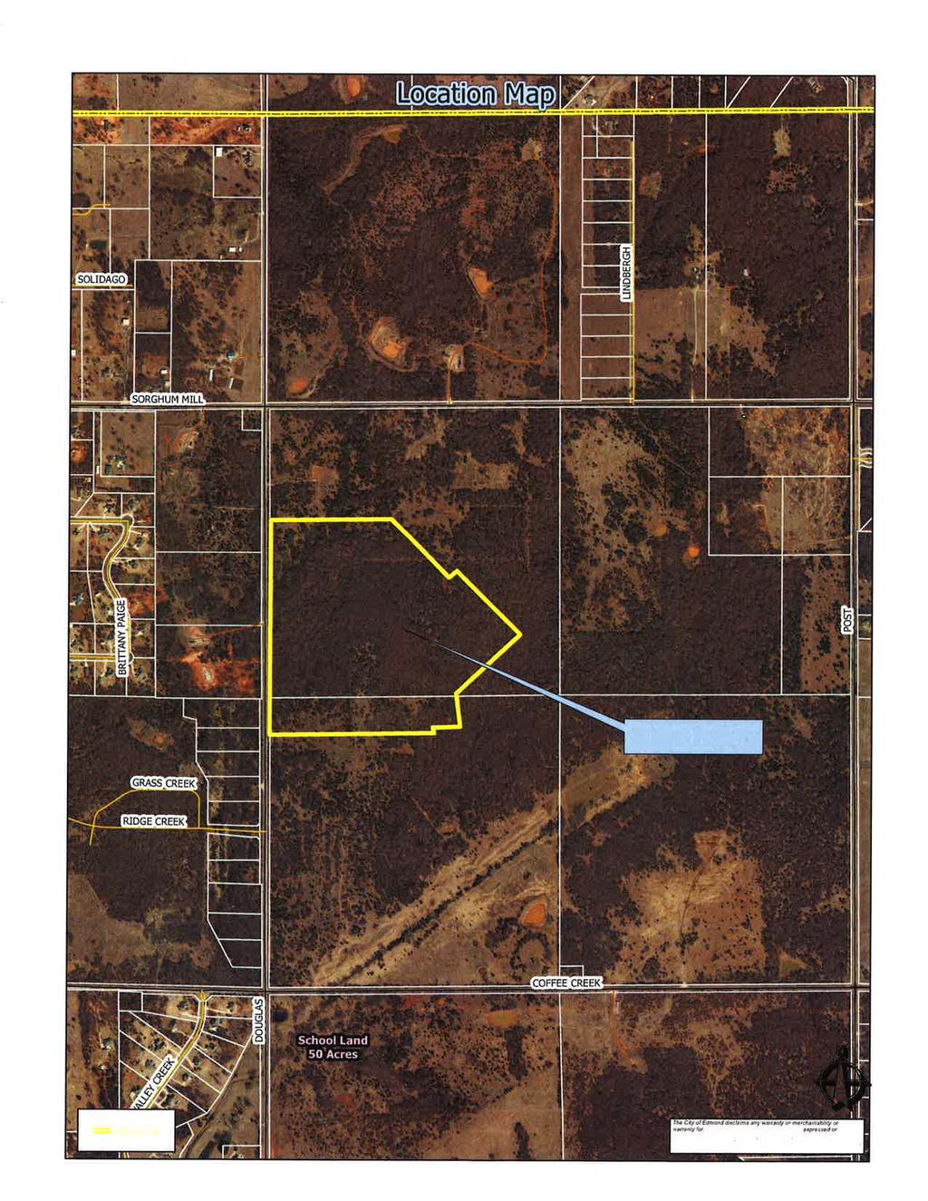
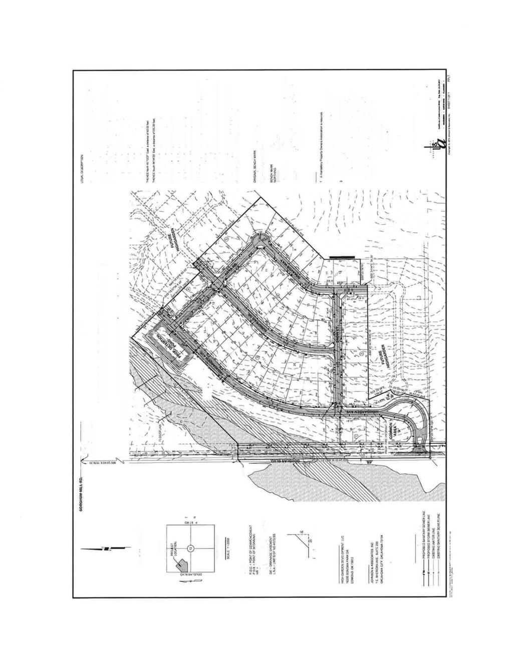
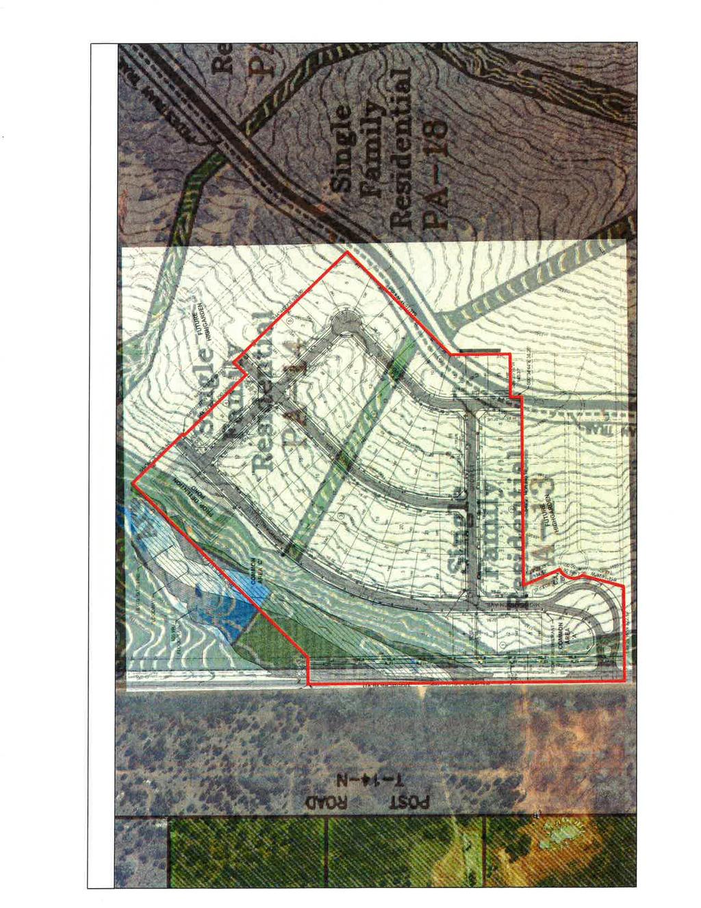
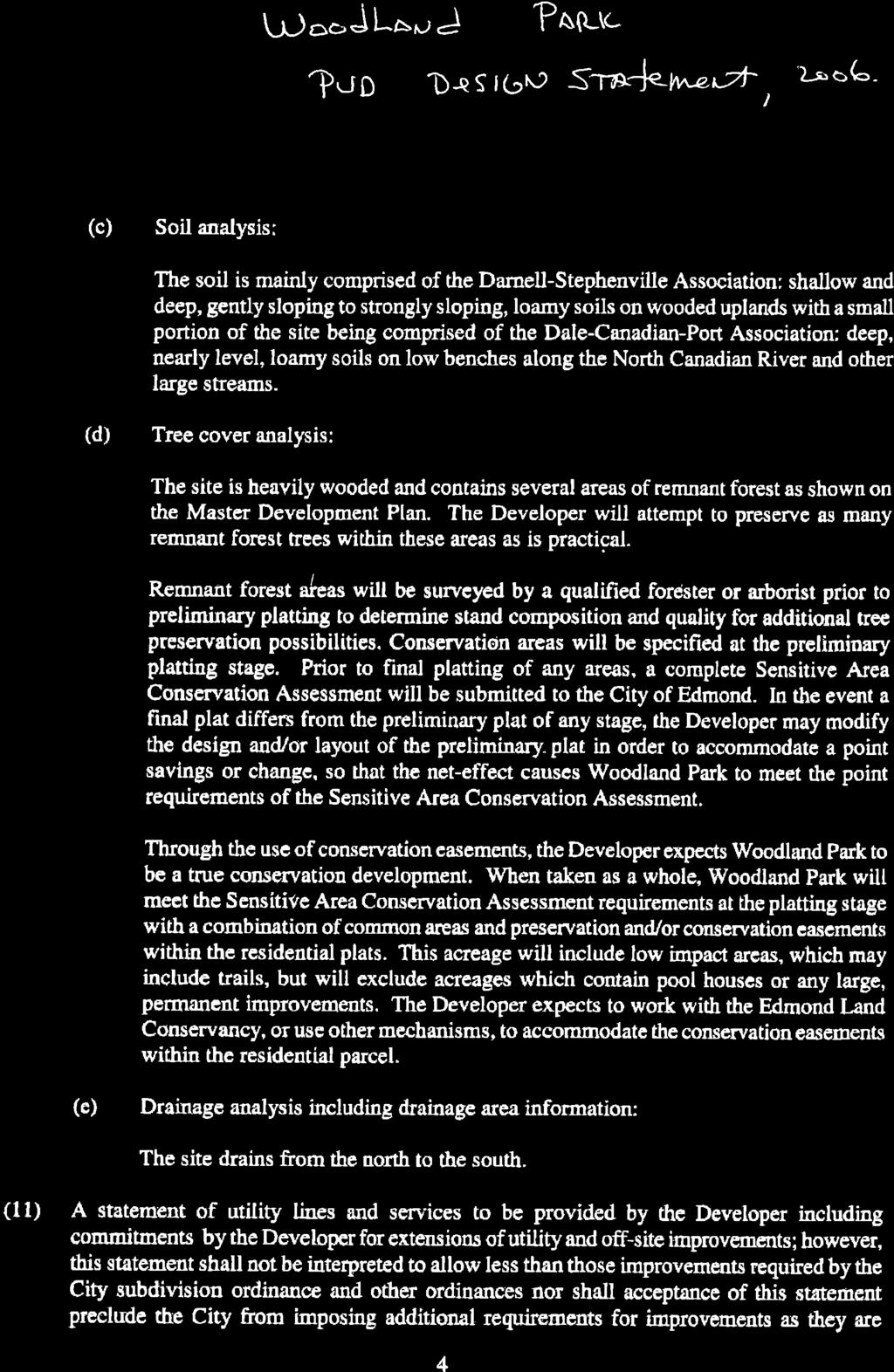
12 Edmond Planning Commission 94 May 17, 2016 southeast portion of the property. The owner could build 1,950 homes in that part of the PUD not being changed but those homes will be built on less acreage than was available in The developer is now saying at the interior commercial parcel planned at the beginning of the project is not feasible and he would rather move the sites to the section line corner locations. The developer would like E-1 General Commercial usage on the subject property. The second commercial tract at Covell Road and Douglas Road contains acres. This parcel is adjacent to water but is not available to city sewer. Septic tanks could be used for commercial uses. In addition to the two commercial changes, Matt Austin wants to change from commercial to residential on 40.9 acres, south of Coffee Creek Road, east of the 50 acre school site. There would still be some retail along Coffee Creek Road but a majority of the commercial planned would now be built as single family homes. City utilities could be available to this site. Mr. Austin that the retail is not feasible in the center of this project. The major change that has occurred since the Planning Commission last saw this item is that the majority of the land on the north side of Covell Road, originally requested for commercial has been withdrawn. Motion by Wohl, seconded by Hoose, to approve this request. Motion carried by a vote of 5-0 as follows AYES: Wohl, Hoose, Moyer, Rainey and Chairperson Moore NAYS: Members: None The next item on the agenda was Case #PR Public Hearing and Consideration of Preliminary Plat approval for the Highgarden Addition Phase 1 with private streets located a one quarter mile south of Sorghum Mill Road and east of Douglas Boulevard. (Highgarden Development, LLC) Highgarden development is planning 65 single family homes on 31 acres in the Woodland Park Planned Unit Development. These lots will connect to city water and sewer. The streets will be private. The notices have been given to the Planning Commission for the preliminary plat/private street discussion. Bob Birchell was hired by the owner as a consulting forester to perform a Sensitive Areas Conservation Assessment, which in part includes evaluation of the proposed tree preservation areas for Woodland Park. That requirement is in the PUD and needs to be completed prior to City Council review. The lot size is generally 75 x 145 for a total of 10,730 square foot lots. The developer has completed a drainage study and plans for a detention pond adjacent to the creek. There are several common areas and the project will be gated. The gate location needs to meet the Gate Standards with a queuing lane allowing four cars to back up outside of the Douglas traffic lanes. Ninety foot of right-of-way is provided along Douglas Boulevard to meet the Master Transportation Plan. The preliminary plat indicates that there will be several other sections to Highgarden Addition. The Woodland Park PUD identifies a series of greenbelts, one of which that does extend through this addition in the center of the blocks. In the letter from April 25, 2016 the developers engineer indicates that he does not wish to have the greenbelt set aside in
13 Edmond Planning Commission 95 May 17, 2016 the plat. Even with private streets sidewalks are expected and are valuable to disabled residents. The developer is leaving the creek area with the largest common area being Area C. In this particular PUD there is no density credit needed to offset a high density area with the lesser density from another area. The open space is additional land that may be flood plain, detention or common area that is part of an amenity for the addition including the entry area, which takes up more space due to the gate. It would be a policy judgment, but it may be more significant to leave groups of tree preservation areas rather than to leave the greenbelts that would likely be graded for the lot, street and utility installation. The exception would be if the trees exist on the greenbelt shown on the original PUD Master Plan. Motion by Rainey, seconded by Hoose, to approve the continuation of this request to the June 7 th Planning Commission meeting. Motion carried by a vote of 5-0 as follows: AYES: Rainey, Hoose, Wohl, Moyer and Chairperson Moore NAYS: None The next item on the agenda was Case #PR Consideration of Final Plat for The Villas of Edmond located on the east side of Kelly Avenue, a quarter of a mile north of 15th Street. (Philip Patterson) Phil Patterson is working with the buyer for The Villas of Edmond Senior Housing planned at this location. The immediate developer is Rich Smith. The overall land area is 5.97 acres for the Villas Senior Housing. The Patterson property would be 2.65 acres consisting of Lot 1 and Lot 3. The remainder of the property along the front of Kelly Avenue is common area due to an extensive flood plain. The access drive and cross access is shown as Lot 1 but may need to be identified as Common Area A to emphasize the cross access to Lots 1 and Lot 3. The Villas property is zoned multi-family allowing for 52 units. The Villas Apartment building is three stories in height. The Patterson property is zoned Restricted Light Industrial. The offsite detention area is on the Phil Patterson property south of the drive and is critical for The Villas project, otherwise there is no detention for the apartments. As discussed with the preliminary plat, The Villas have made an arrangement with the mobile home park to the east for a second access. This primarily is an emergency access and maybe gated in accordance to fire department requirements and standards. The plat provides for the necessary utility easements. The Apple Village Mobile Home Park is located to the east. There are commercial buildings to the south, except for an undeveloped commercial parcel south of The Villas main lot. There is also commercial to the north accessible by Evergreen Street. The conditions for approval include the following: 1. The access easement from Kelly Avenue shall allow for the Patterson ownership to cross access. 2. The public water line shall also be accessible to the Patterson property. 3. The sanitary sewer access shall also be accessible to the Patterson property.
14 Edmond Planning Commission 96 May 17, All public or private utility easements, particularly for the private detention area shall be provided or labeled as needed, including the access to the mobile home park. George Marquez spoke for the applicant. He indicated that there would be the cross access agreements with the access to Kelly Avenue and the emergency access through the mobile home park. Motion by Hoose, seconded by Rainey, to approve this request. Motion carried by a vote of 5-0 as follows: AYES: Hoose, Rainey, Wohl, Moyer and Chairperson Moore NAYS: Members: None The next item on the agenda was Case #Z Public Hearing and Consideration of Edmond Plan Amendment from A Single Family Dwelling District to D-1 Restricted Retail Commercial located on the southwest corner of Covell Road and Western Avenue. (Andrew and Teaona Njoo) The following general planning considerations represent some of the factors evaluated in reviewing justifications for Plan Map Amendments. 1. Infrastructure: City water is located along Covell Road. A new line was extended even further west to serve the two schools on Pennsylvania Avenue. There is a sewer line in the creek west of the site. A septic tank may be the best solution for wastewater. The Oklahoma City sewer line will be very difficult to access. Mr. Njoo is generally familiar drainage detention requirements. 2. Traffic: Covell Road has been discussed as a major east west. The right-of-way is being provided for that major improvement either with the site plan or the plat. Western Avenue right-of-way would be provided with the right-of-way standard required. 3. Existing zoning pattern: North A Single Family, Covell right-of-way South A Single Family, is also in a flood plain. East A Single Family, Western Avenue right-of-way West A Single Family. but is unbuildable due to the flood plain 4. Land Use: North Undeveloped South Immediately South Undeveloped East Undeveloped West Undeveloped 5. Density: N/A
15 Edmond Planning Commission 97 May 17, Land ownership pattern: North Single 12+ acre parcel South Large ownerships East Large ownerships West Large ownerships 7. Physical features: Only the corner is buildable, the remainder of the land is flood plain. 8. Special conditions: Flood plain, right-of-way requirements for Covell Road improvements later. 9. Location of Schools and School Land: nearest school is on Pennsylvania Avenue, south of Covell Road. 10. Compatibility to Edmond Plan: Not projected in This site is limited for many uses, not the best location for a home. 11. Site Plan Review: Would be required if zoned commercial. Jason Spencer represented the applicant. He indicated that there was substantial buffer around the small 2 acre tract from the nearest single family residential. Any development of the property will be low intensity. The owner understands the flood plain limits and the limits that could be created for sewer service. Erin Sandwall submitted a letter of objection, since she had to leave the meeting. Motion by Rainey, seconded by Hoose, to approve this request. Motion carried by a vote of 4-1 as follows: AYES: Rainey, Hoose, Wohl and Moyer NAYS: Chairperson Moore The next item on the agenda was Case #Z Public Hearing and Consideration of Rezoning from A Single Family Dwelling District to D-1 Restricted Retail Commercial generally located on the southwest corner of Covell Road and Western Avenue. (Andrew and Teaona Njoo) Andrew and Teaona Njoo is requesting acres to be rezoned from A Single Family to Restricted Retail Commercial at Covell Road and Western. This land is vacant. The uses in the general area St. Monica Catholic Church at 2001 North Western. The Kingsbury Addition located west of the bridge, west of this property, several 100 feet to the west and the Fall Brook Addition several 100 feet to the northeast. The land to the northwest is undeveloped and is adjacent to a major creek. City water is adjacent to this property. Sewer is located to the west. The site is large enough for a septic tank for limited commercial usage. Mr. Njoo is aware of the right-ofway needed on Covell Road and Western Avenue based on the Master Transportation
16 Edmond Planning Commission 98 May 17, 2016 Plan. The owner has worked with an engineer and studied the flood plan, which has a major impact to the property. The D-1 usage will allow for office and light retail uses. Motion by Rainey, seconded by Hoose, to approve this request. Motion carried by a vote of 4-1 as follows: AYES: Rainey, Hoose, Moyer and Wohl NAYS: Chairperson Moore The next item on the agenda was Case #U Public Hearing and Consideration of Specific Use Permit and Case #SP to include a Site Plan, for a Victory Car Wash located at 1101 West Danforth Road. (Muhammad N. Siddiqui) Planning Department 1. Existing zoning Commercial Planned Unit Development to allow a car wash and other limited commercial uses. 2. Setbacks From the property line to the vacuum area would be 60 feet. The building itself sets back 140 feet from the property area. The side yard setback to the east is 80 feet, side yard setback to the west 132 feet, and setback to the north 97 feet. 3. Height of buildi ng 28 feet 4. Parking The parking spaces are oriented to the car wash process. There is a flow of traffic around the building on the north with 29 spaces for vacuum and other finishing of the car after the wash. There is a queuing lane to stack a considerable number of cars around the building. The building is on 3,840 square feet. Bicycle parking will be required and Jan Fees will inspect. 5. Lot size Is 334 feet by 342 feet before the right-of-way is only provided along Danforth Road. This site is approximately 96,860 square feet. 6. Lighting Plan This area is not a sensitive border. The School District owns property to the east. There is a strip shopping center to the west and Hibdon Tire Center to the south. The School District also owns property to the north, as well as, the original property owner Mr. Novotny. 7. Signage One ground sign is planned out of the 70 foot right-of-way required. The sign will be six foot tall and 42 square feet. Wall signs may also be used, meeting the code. 8. General architectural appearance The building is a combination of light brown brick veneer and a dark blue EIFS. The front of the building will have a number of windows, common to car washes.
17 Edmond Planning Commission 99 May 17, Sensitive borders N/A 10. Mechanical equipment Will be located on the roof. 11. Fencing/screening Not required except for the dumpster enclosure. Engineering Department 12. Driveways, access management and paving There is one driveway into the property located on the west side of the property. That driveway meets the Access Management Standard between the shopping center and School District driveway on either side of the property. Mr. Novotny will also use the driveway to care for his horse pasture to the north. 13. Water and wastewater plans Are available for service and will be connected. 14. Drainage, detention and grading Engineering has completed their drainage review. Building and Fire Code Services 15. Applicable Building Code, Fire Code a. A fire hydrant will need to be added on site along a fire department access road. b. fire department access is adequate Landscaping/Urban Forestry 16. Lot area = 96,860 sf % required = 10 Landscape area required: 9,686 SP Landscape area: 28,000 Frontage area required: 4,843 SP Frontage area: 6,800 Total PU required: 775 SP Total PU: 775 PU within frontage required: 387 SP PU within frontage: 412 Evergreen PU required: 310 SP Evergreen PU: Solid Waste Department There is a dumpster adjacent to the front parking area, nearest to the building. 18. Edmond Electric Department Will serve. Mohammad Siddiqui requested approval. Lugene Jones representing the ENA was concerned about a less intense commercial use would be better.
18 Edmond Planning Commission 100 May 17, 2016 Motion by Hoose, seconded by Rainey, to approve this request. Motion carried by a vote of 5-0 as follows: AYES: Hoose, Rainey, Moyer and Wohl NAYS: Chairperson Moore There was no New Business. Motion by Rainey, seconded by Wohl, to adjourn. Motion carried by a vote of follows: AYES: Rainey, Wohl, Moyer, Hoose and Chairperson Moore NAYS: Members: None 5-0 as Meeting adjourned at 7:30 p.m. Barry K. Moore, Chairperson Edmond Planning Commission Robert Schiermeyer, Secretary Edmond Planning Commission
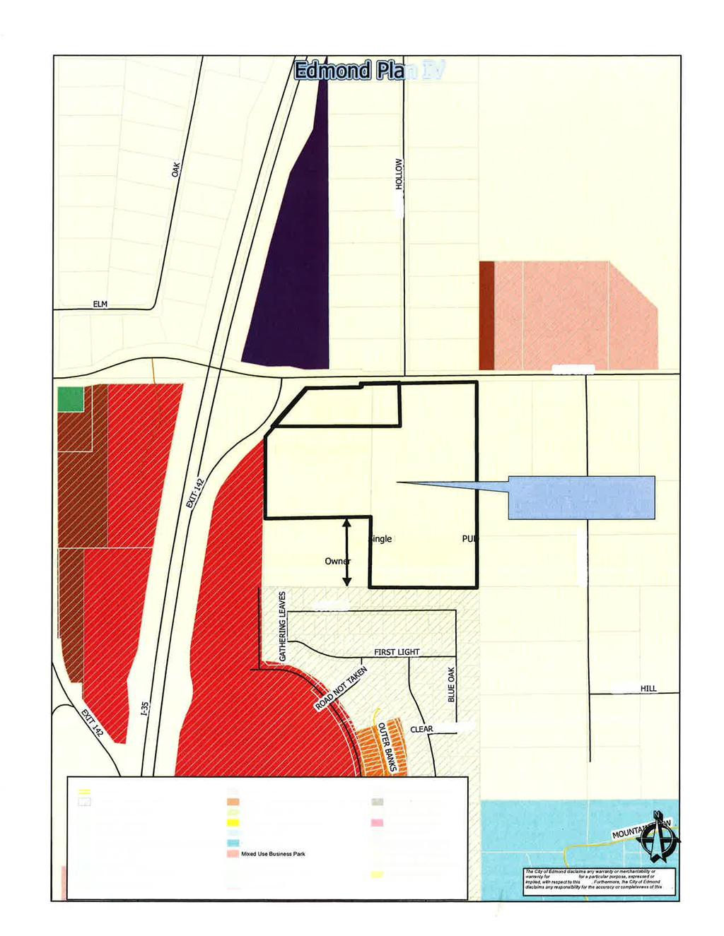
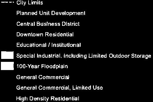
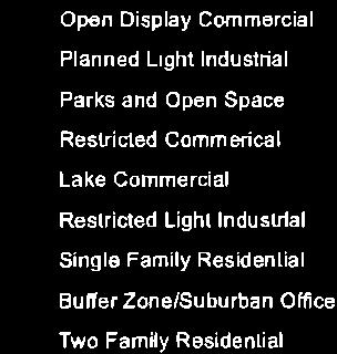
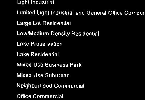
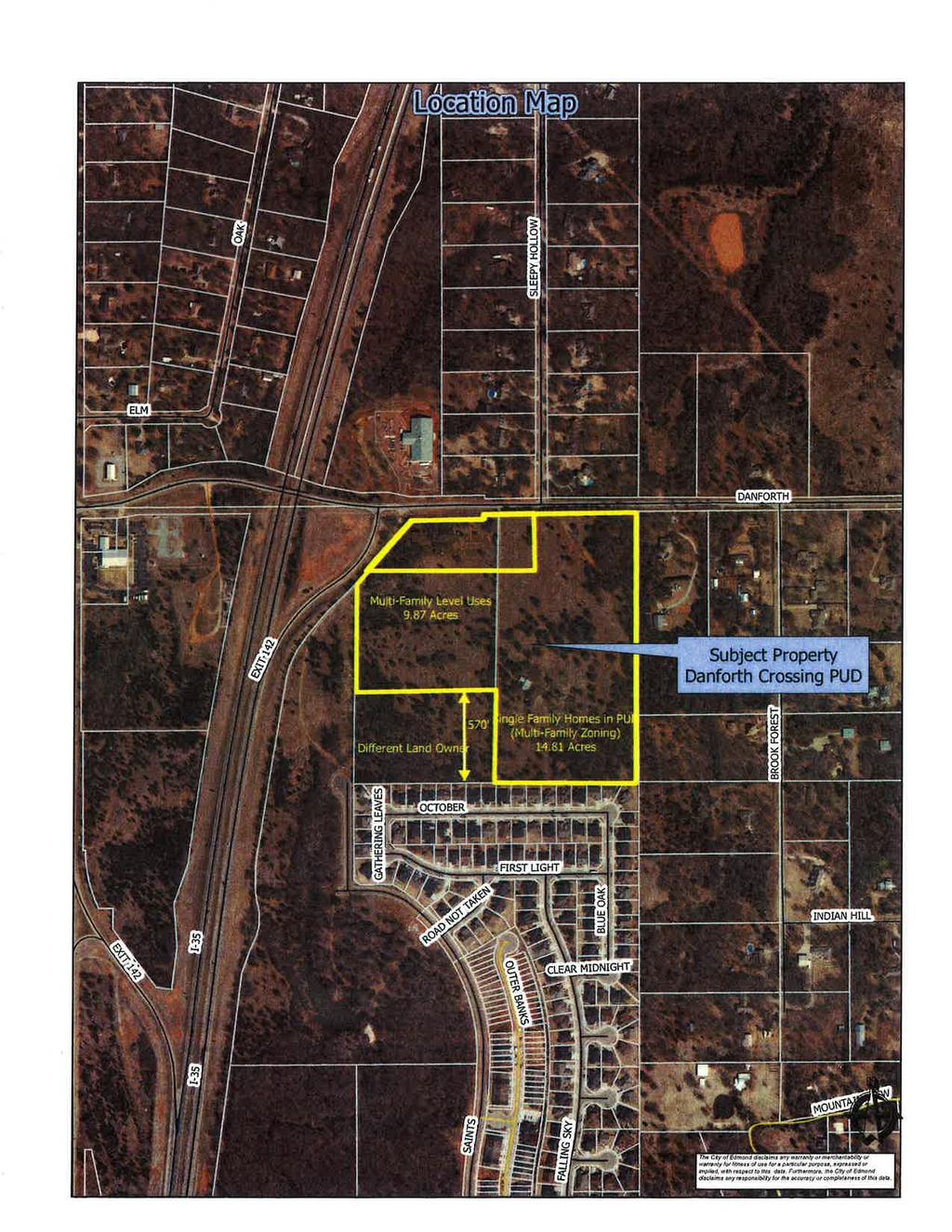
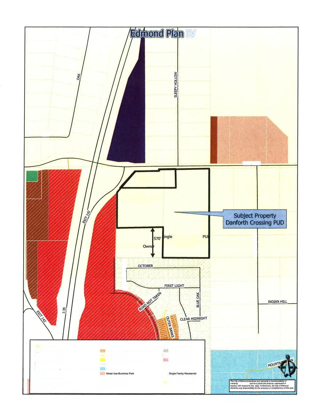
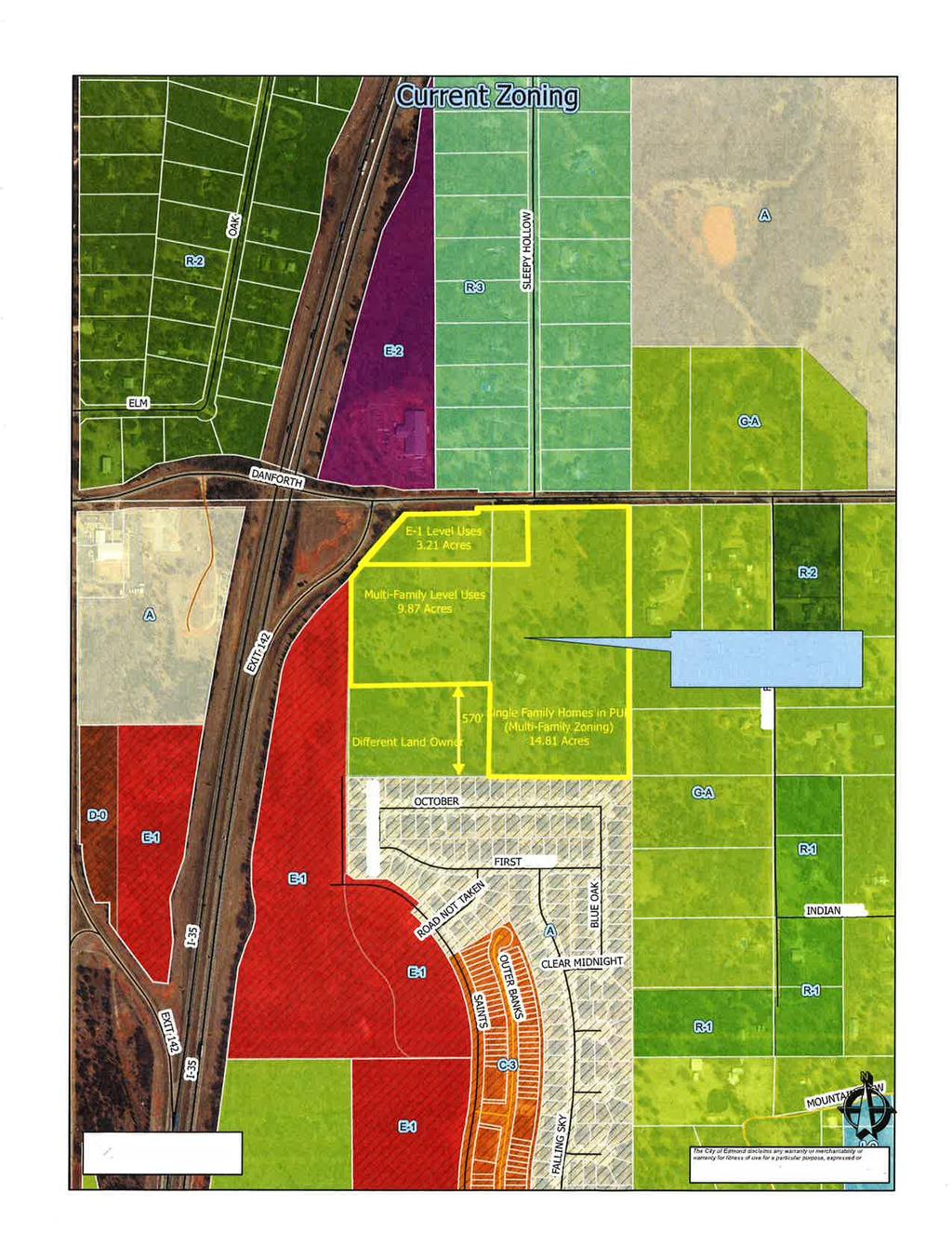
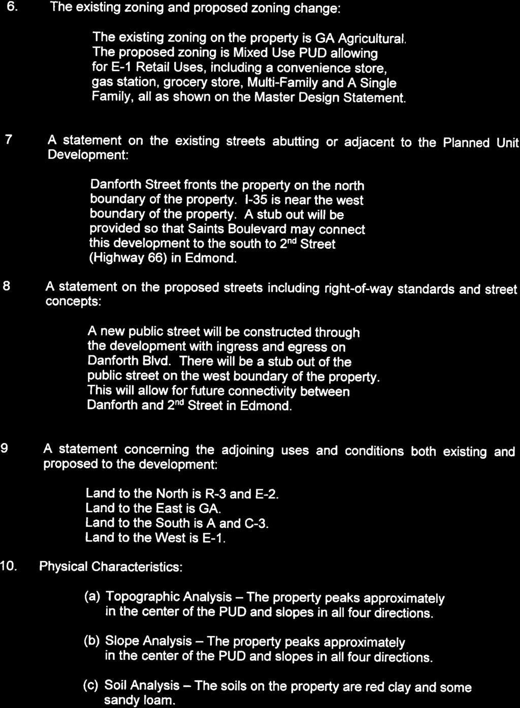
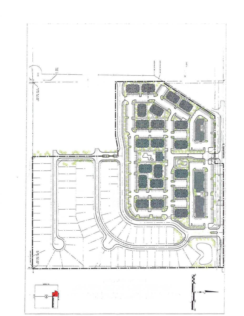
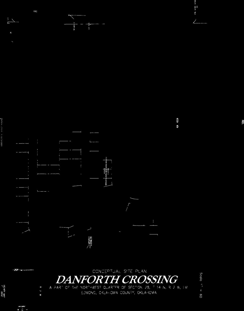
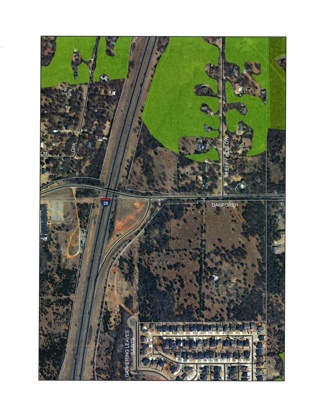
19 Planning Commission 3. Meeting Date: 06/07/2016 From: Bob Schiermeyer Department: Planning/Zoning Information RE: Case #Z Public Hearing and Consideration of Edmond Plan Amendment from Single Family to Commercial Planned Unit Development ( E-1 uses) on 3.21 acres and from Single Family to Multi-family Residential Planned Unit Development on acres (to include 252 apartments and 70 single family lots) generally located south of Danforth Road and east I-35, north of Arbor Creek Summit. (Danforth Crossing Happy Land, LLC) The following general planning considerations represent some of the factors evaluated in reviewing justifications for Plan Map Amendments. 1. Infrastructure: City water is available, adjacent to the site on Danforth Road. Grading of the property may be significant in order to prepare the site. There is sewer to the south at the Arbor Creek of the Summit Addition. 2. Traffic: A Traffic Study has been prepared by TEC. This location is near the I-35 off ramp and there will be requirements on how close the nearest driveway can be on Danforth Road. There are no improvements planned on Danforth Road in the near future. There is no traffic signal planned on Danforth Road or a connection to Saints Boulevard, which is off-site and on another ownership. 3. Existing zoning pattern: North E-2 and Special Use Permit for the Seventh Day Adventist church and single family South Single family East Single family West I Land Use: North Church and homes in Sleepy Hollow South Single family, Arbor Creek at the Summit East Single family, Kanalys Collegewood Acres West I Density: 14 units per acre, considering the 24.6 acres, excluding the streets. The PUD Master Plan limits the actual usage to single family detached homes to the west of Kanalys Collegewood Acres and on the south side of the property next to Arbor Creek at the Summit. 6. Land ownership pattern: North Single family and church, 2 acre lots for residential South Single family on urban lots East Two acre lots or larger acreage West I-35
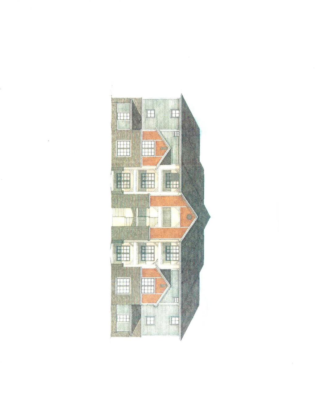
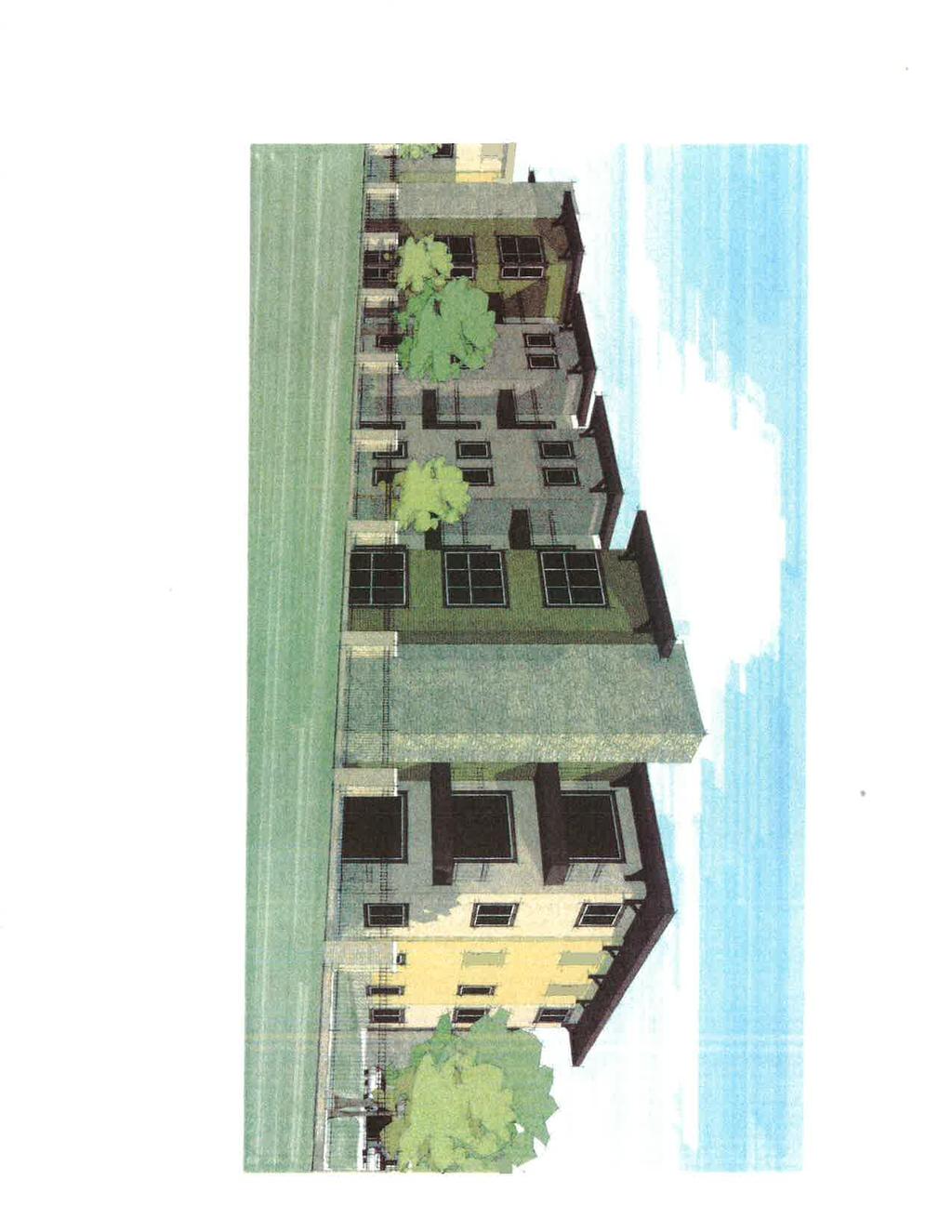
20 7. Physical features: Rolling terrain 8. Special conditions: Traffic improvements related to the Interstate proximity, driveway or street location. 9. Location of Schools and School Land: N/A 10. Compatibility to Edmond Plan: The 2006 Edmond Plan left the property projected for single family. This parcel is a critical location based on potential access from Danforth Road and/or Saints Boulevard. Since there a multiple ownerships it has never been determined how access might be possible. The Edmond Plan was completed in 2006 and it was known that utilities were likely available to this property but a higher land use was not suggested based on circulation issues. Danforth Road is not programmed to be improved for some time and there is a unique bridge across I-35 at the Danforth Road location. The usage that has developed is single family, Arbor Creek at the Summit is the most recently constructed. Sleepy Hollow was developed in the early 1980 s and the Kanalys Collegewood Acres was started well before that time. However, the zoning immediately west is E-1 General Commercial, just east of I-35. A Switzer Locker was withdrawn from consideration on that property. The Seventh Day Adventist Church is zoned E-2 Open Display but at this time it seems unlikely to have that type of use. There are 246 lots in Arbor Creek at the Summit including The Porches project. The subject development would contain 322 units including the single family and the multi-family units. The land use pattern created by the proposal places single family lots next to single family lots and allows a 570 foot separation from the apartments to existing single family lots. The land use layout would be appropriate for similar locations along an interstate highway. 11. Site Plan Review: Site Plan review is required for multi-family and commercial. Danforth Crossings PlAm Attachments

21

22
23
24
25
26 Planning Commission 4. Meeting Date: 06/07/2016 From: Bob Schiermeyer Department: Planning/Zoning Information RE: Case #Z Public Hearing and Consideration of Rezoning from G-A General Agricultural to Commercial Planned Unit Development ( E-1 uses) on 3.21 acres and rezoning from G-A General Agricultural to Multi-family Residential Planned Unit Development on acres (to include 252 apartments and 70 single family lots) generally located south of Danforth Road and east I-35, north of Arbor Creek Summit. (Danforth Crossing Happy Land, LLC) Randel Shadid is representing Happy Land, LLC in requesting 3.21 acres of E-1 level Commercial PUD zoning on the southeast corner of Danforth Road and I-35. This development is an overall PUD involving multi-family and single family uses in addition to the commercial. The Sleepy Hollow Addition is located to the north and Edmond Seventh-Adventist Church is located to the northwest. The Kanalys Collegewood Acres Addition is located to the east and the Arbor Creek at the Summit is located to the south. There is another property owner Arcadia Premium Development LLC, located south of the multi-family part of the PUD; and that tract is currently zoned G-A Agricultural. Water and sewer lines should be accessible to this area. City water line extends along the I-35 frontage and extends through Sleepy Hollow Addition and north to the Cross Timbers Municipal Complex. The water line is adjacent to a portion of the property along Danforth Road and would have to be extended to far east property line. The sewer lines are in Arbor Creek Summit Addition to the south. The property drains in several different directions and sewer could be reached in the southeast or southwest corners of the property. The land will be substantially graded with the hill on the property lowered for drainage, grading and sanitary sewer purposes. The 9.87 acre tract planned for multi-family PUD would provide for 252 apartment units. The buildings could be three stories in height. This land is in the I-35 Corridor and the additional landscaping requirements and exterior building materials would apply. One of the clear benefits of this PUD is that the land to the east side and the south side of the development would remain Single family detached homes adjacent to Kanalys Collegewood Acres and Arbor Creek at the Summit Additions. A traffic study has been submitted. Two traffic signal lights are identified by the traffic impact of this request. The bridge at Danforth Road has not been scheduled for any improvements in the future. Danforth Crossings Rez1 Danforth Crossings PUD Attachments
27
28
29
30
31
32
33
34
35
36
37

38
39
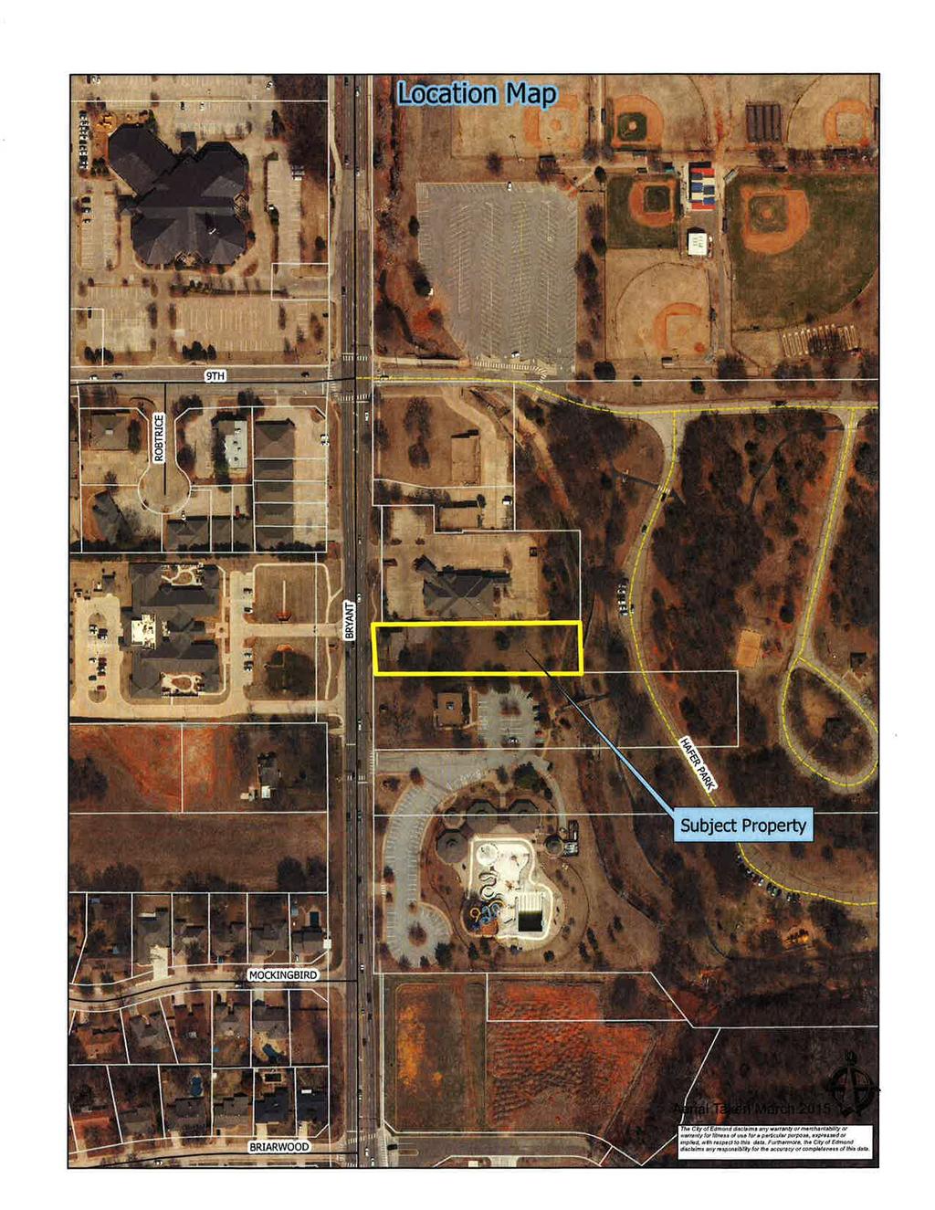
40 Planning Commission 5. Meeting Date: 06/07/2016 From: Bob Schiermeyer Department: Planning/Zoning Information RE: Case #SP Public Hearing and Consideration of Site Plan Approval for an office building located on the east side of Bryant Avenue, one eight-mile south of 9th Street. (Ferrell-Johnson Wealth Management Office) Planning Department 1. Existing zoning D-O Suburban Office 2. Setbacks The front setback is 65 feet from the property line, if additional right-of-way is granted. The setback would be 76 feet from the property line if no right-of-way is granted. The side yard setback is 38 feet to the south, the side yard setback to the north is 12 feet and the rear yard setback is 172 feet. 3. Height of building 35 feet, 38 feet to the top of the cupola. 4. Parking 41,690 square feet lot. The building is approximately 10,000 square feet. A bicycle rack will be required and Jan Fee s will inspect. There are 35 parking spaces provided. This site ties into the Edmond Convention Tourism Bureau. There is a shared parking arrangement with the City and a cross access drive. The project is not over parked. 5. Lot size 41,690 square feet lot 6. Lighting Plan Light poles will not exceed 24 feet in height including the base. 7. Signage One ground sign 6 foot tall and 42 square feet. 8. General architectural appearance The building is brick veneer. The pitch of the roof is 12/7 with composition shingles. A portion of the building is two story with a walk out area based on the slope of the land. 9. Sensitive borders N/A 10. Mechanical equipment Located on the ground due to the pitched roof. 11. Fencing/screening Only applicable to the dumpster enclosure located on the east side of the property. Engineering Department 12. Driveways, access management and paving One drive on Bryant Avenue. There has
41 already been a discussion on the Access Management Standards with the City Council. The right-of-way will be 50 feet in this case, a 10 ½ foot area will be left for landscaping and then there will be another 20 foot utility easement for the front parking. 13. Water and wastewater plans Water and sewer are adjacent and are being connected for service. 14. Drainage, detention and grading Drainage detention is being meet to the east side of the building. Building and Fire Code Services 15. Applicable Building Code, Fire Code Fully compliant building code standards will take place at time of permit. The building is to be equipped with an automatic sprinkler system Ensure the fire department connection is within 100ft of a fire hydrant The fire control room shall be equipped with exterior access only The grade of 10% on the entrance from Bryant exceeds the 8% maximum grade set forth by the City of Edmond title 17. The building department and fire department are currently working with the engineer to resolve this issue. An interesting building has been designed using the slope of the land but since the slope is so severe there has been a continual modification of the plans to allow fire access with the proper grade. The back of the truck will hit the pavement without the proper transition of slope. The fire department does have a minimum standard they will accept. The condition of approval needs to state the grading of the property and the slope of the final paving shall be approved by the Engineering Department and Fire Department. Landscaping/Urban Forestry 16. Lot area = 41,690 sf % required = 10 Landscape area required: 4,169 SP Landscape area: 4,169 Frontage area required: 2,085 SP Frontage area: 2,085 Total PU required: 334 SP Total PU: 509 PU within frontage required: 167 SP PU within frontage: 317 Evergreen PU required: 133 SP Evergreen PU: Solid Waste Department Dumpster enclosure is located on the southeast side of the property. 18. Edmond Electric Department Edmond Electric will serve. Ferrell-Johnson SP Attachments
42
43
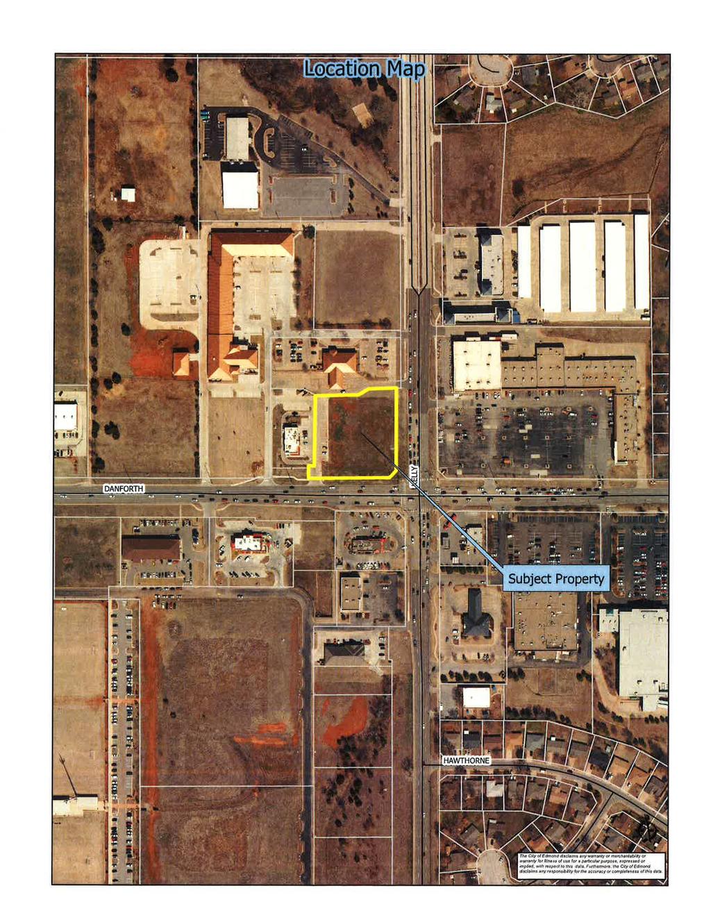
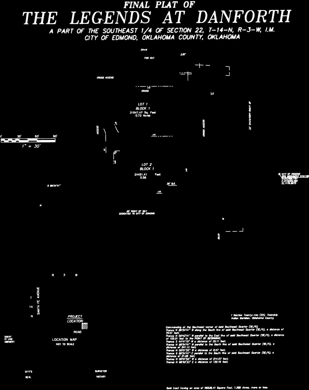
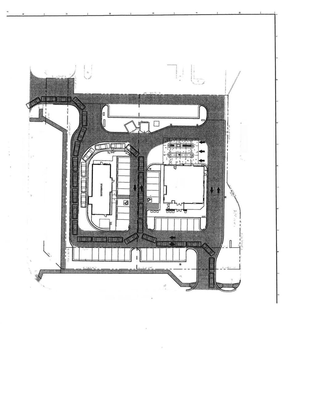
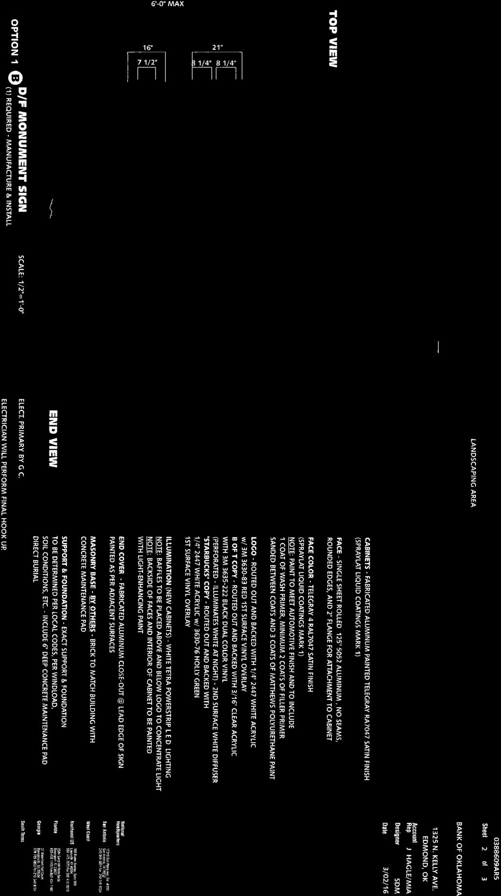
44 Planning Commission 6. Meeting Date: 06/07/2016 From: Bob Schiermeyer Department: Planning/Zoning Information RE: Case #SP Public Hearing and Consideration of Site Plan Modification regarding the ground signs for Bank of Oklahoma and Starbucks, to include a variance for off-site signs located on the northwest corner of Danforth Road and Kelly Avenue. (Bank of Oklahoma/Starbucks) Bank of Oklahoma is the principle developer of this northwest corner with a pad site for a Starbucks and a pad site for the Bank of Oklahoma. A final plat was submitted identifying two lots in The Legends of Danforth plat. The right-of-way is being provided on that plat in accordance with the Master Transportation Plan. There is also a cross access of the driveways including the use of the driveway offsite west of the Starbucks also shared with Carl Jr s. Starbucks will own Lot 2, Block 1 and Oklahoma Bank will own Block 1, Lot 1. Currently the Bank of Oklahoma owns the entire parcel but the plat will have to be recorded prior to occupancy permits identifying the two individual lots and/or owners. The sign ordinance describes a billboard as follows: Any existing sign or advertising device which advertises products, services or activities unrelated to the property upon which the sign or device is located, whether lawfully permitted or legally nonconforming, except courtesy bench signs at approved public bus stops. A billboard is also listed as a prohibited sign. The request to the Planning Commission and the City Council is that both businesses be permitted to be listed on the two ground signs planned, one on Danforth Road and one Kelly Avenue. The signs would be six foot tall including the base and 40.5 square feet including both sign faces. In this case, the issue is that both business names are on two signs. The considerations of this application are: Right of way was granted in accordance to the Master Transportation Plan or approved in accordance with the Engineering Department recommendation. Access Management Standards as to driveway separation and alignment are being met. The applicants understand that several years into the future a raised median will be placed on Danforth Road and Kelly Avenue prohibiting left turns into either property. Both businesses will operate with multiples cross access internal driveways to facilitate traffic flow on site. Both business have drive-thru facilities. The ground sign locations are also less than 50 feet from the side property line. Attachments
45 BOK/Starbucks SP Mod
46
47
48
49

50

51
52
53
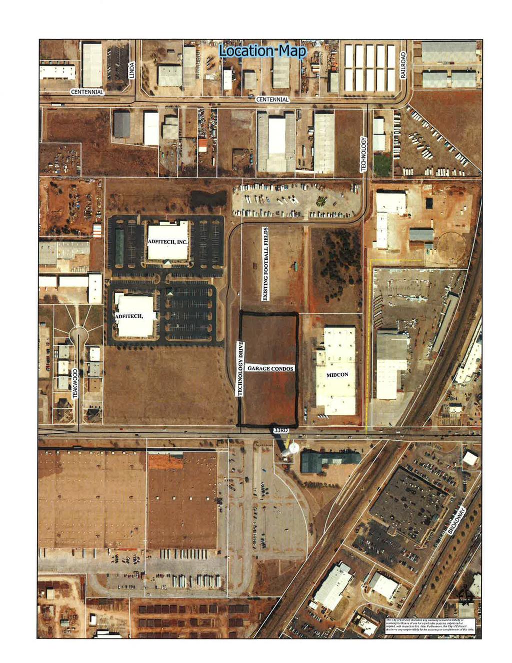
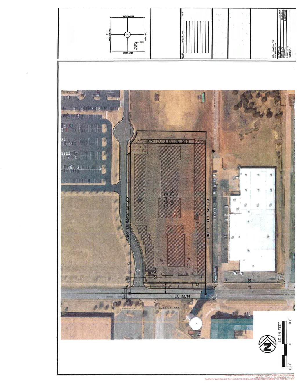
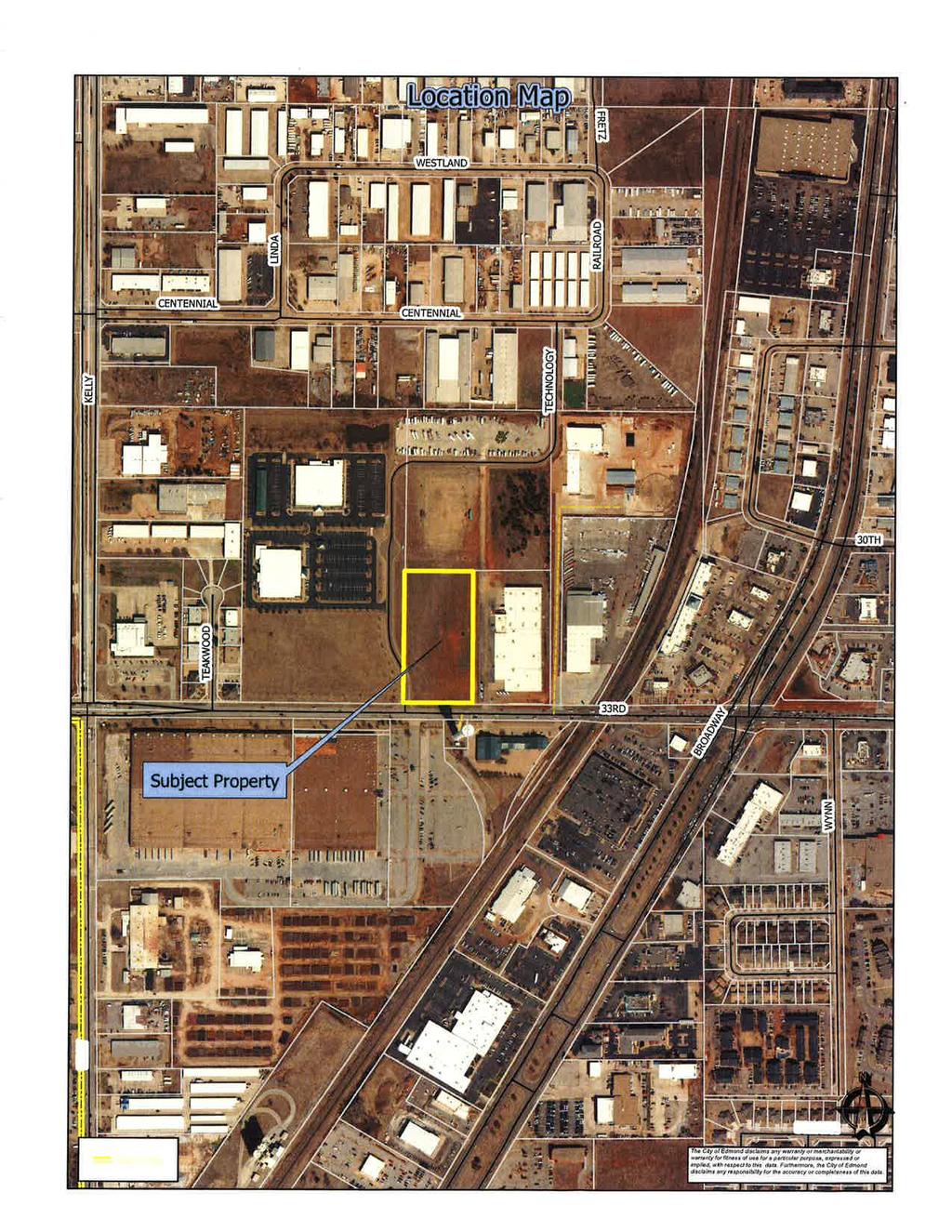
54 Planning Commission 7. Meeting Date: 06/07/2016 From: Bob Schiermeyer Department: Planning/Zoning RE: Information Case #SP Public Hearing and Consideration of Site Plan approval for the Garage Condo s located on the northeast corner of Technology Drive and 33rd Street. (Chris Carllson - Enterprise Holding, LLC) Planning Department 1. Existing zoning F-1 Light Industrial 2. Setbacks The front setback is 33 feet from the property line, the right-of-way is 50 feet from the center line plus another 20 foot utility easement. The standard setback would 50 feet from the property line but the request has been before the City Council with the right-of-way discussion and the setbacks are approved by that action. The setback to the east is 2 feet, the setback along Technology Drive is 2 feet extending to 17 feet. The north setback is 38 feet. 3. Height of building 35 feet 4. Parking The site is 207,592 square feet, which is 4.76 acres. Only four direct parking spaces are provided. Each building is designed for a vehicle, RV or boat to be parked inside the building. The lanes around the buildings are not designed for parking outside the building. It is not appropriate to block the circulation lane with parking spaces. The four spaces are for the employees and new customers. Bicycle racks are required and will be inspected by Jan Fees. 5. Lot size 4.76 aces 6. Lighting Plan The zoning around this property is Light Industrial, Midcon is located to the east, Adfitech is to the west, and there are other commercial buildings to the south and a water tower to the southwest. There is a lighted football field to the north. The light poles will not exceed 24 feet in height but most of the lighting is on the building. 7. Signage One ground sign will permitted out of the right-of-way, 6 feet tall and 42 square feet. The original plans identified 75 square feet per side, which is not permitted. There will be two signs one on Technology Drive and one on 33rd Street, 300 feet apart. 8. General architectural appearance The garages contain 86,008 square feet the offices are 1,000 square feet. The exterior walls contain tilt up concrete panels, the rollup doors will be metal, the roofs will be standing seam metal. There is also some metal panels on the outside exterior adjacent to the polycarbonate panels. The general area does contain some metal buildings. 9. Sensitive borders N/A 10. Mechanical equipment There will be air conditioning units on the roof screened by parapet walls.
55 11. Fencing/screening Security fencing on the exterior. Engineering Department 12. Driveways, access management and paving There is one driveway on Technology Drive and it is a gated access for security. No drives on 33rd Street. 13. Water and wastewater plans Water and sewer are adjacent and will be connected for service. The water will have to be extended to provide for internal fire hydrants. 14. Drainage, detention and grading Detention plans have been prepared and there is a detention pond on the north side of the property. Building and Fire Code Services 15. Applicable Building Code, Fire Code Reviewed by the Building Department and compliant. An additional fire hydrant will need to be added near the entrance of the complex. The gate at the entrance of the complex will need to be permitted before it is placed in service. Fire department access is adequate. Each building will be equipped with an automatic sprinkler system. Landscaping/Urban Forestry 16. Lot area = 207,592 sf % required = 10 Landscape area required: 20,759.2 SP Landscape area: 24,329 Frontage area required: 10,380 SP Frontage area: 19,000 Total PU required: 1,661 SP Total PU: 1,714 PU within frontage required: 830 SP PU within frontage: 1,714 Evergreen PU required: 664 SP Evergreen PU: 1, Solid Waste Department A dumpster location has been identified. The access lanes are substantial to provide for the RV maneuvering and indoor parking. There should be adequate space to access a dumpster. The gate will need to meet Edmond requirements. 18. Edmond Electric Department Edmond Electric will serve. GarageCondosSP Attachments
56
57
58 Planning Commission 8. Meeting Date: 06/07/2016 From: Bob Schiermeyer Department: Planning/Zoning Information RE: Case #PR Public Hearing and Consideration of Preliminary Plat for the Garage Condos located on the northeast corner of Technology Drive and 33rd Street. (Chris Carllson) Mr. Carllson would like to build a vehicle oriented storage facility north of 33rd Street. MIDCON Data is located to the immediate east; a practice football field is located north of the site; Adfitech is located to the west; and the city water tower is located to the south. This is a specialized garage facility, providing climate controlled storage for vehicles. Motor homes would be provided for, and a security and fire protection system will be provided. City water and sewer will be available at each building. Six buildings are planned at this time. The parcel is zoned F-1 Light Industrial, and is situated on 5.43 acres. A variance has already been approved for the right-of-way requirement on 33rd Street, and in this case, that includes a setback variance also. The setback would be 30 feet from the property line on 33rd Street, rather than 50 feet. The interior spaces are intended to be rented on a unit ownership basis. Fencing will occur around the entire perimeter. The access to the property will be from a single gate on the Technology Drive. The improvements will include water, sewer, detention, fire hydrants, and an appropriate grading and erosion control. Utility easements are shown on the plat. There will be no curb cuts on 33 rd Street. Garage Condos PP Attachments
59
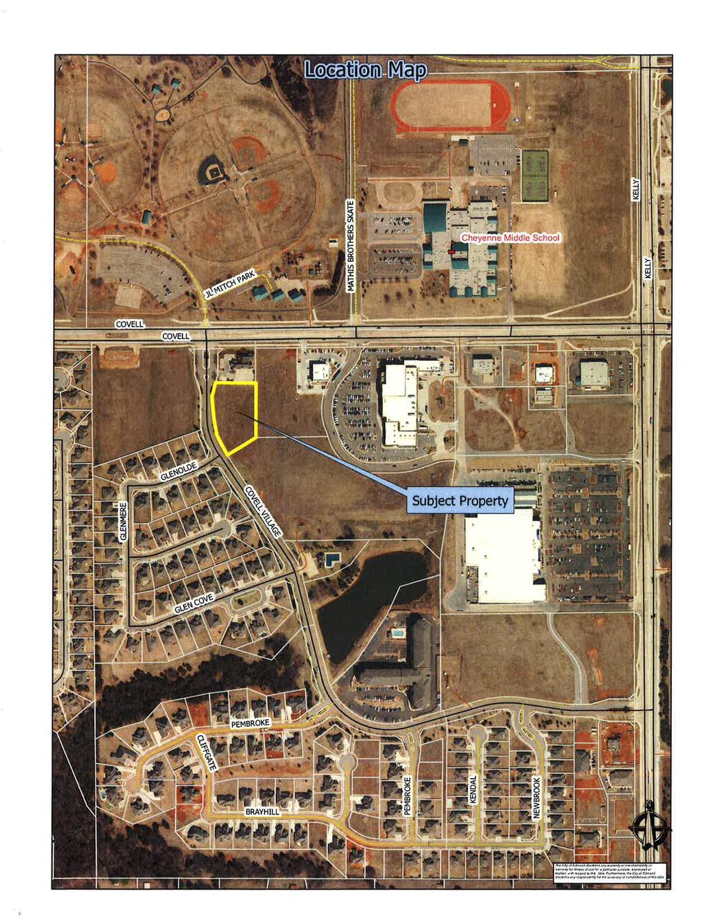
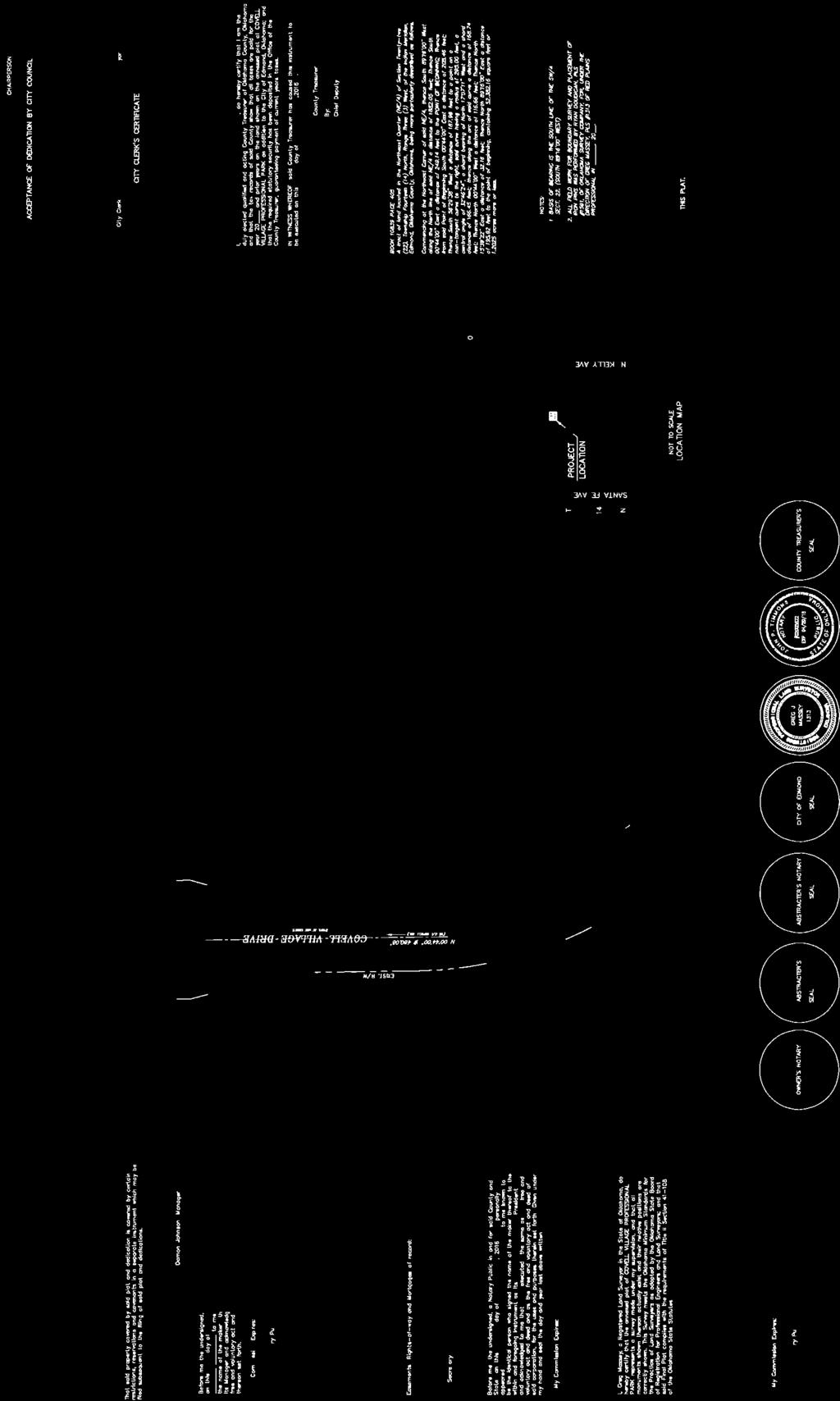
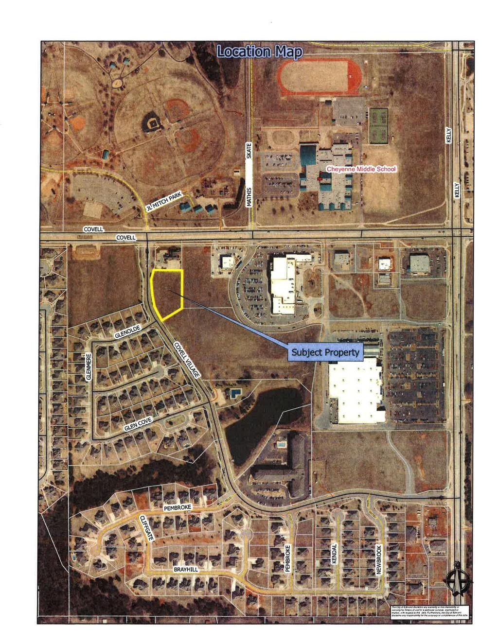
60 Planning Commission 9. Meeting Date: 06/07/2016 From: Bob Schiermeyer Department: Planning/Zoning Information RE: Case #PR Consideration of Final Plat for Covell Village Professional Park located south of Covell Road and east of Covell Village Drive. (Damon Johnson) Damon Johnson is requesting a 1.20 acre plat to be approved for offices located to the east of Crossing Community Church and south of the Damon Johnson Dental office. This property is zoned for Office Use as part of the Covell Village Planned Unit Development. The PUD is progressing at a fairly rapid rate starting with the Walgreen Pharmacy at Kelly Avenue and Covell Road. Earlier buildings include Prime Bank, Lowes Home Improvement Center, Three Girl s Photography, Pepperoni Grill, Uptown Market Shopping Center and Qdoba Restaurant. The Covell Village PUD includes Single family and multi-family residential. There is no preliminary plat on this project since it is only 1.20 acres which exempts the preliminary plat under the code. There is a 25 foot front setback along Covell Village Drive and there will be cross access between the lots, since Lot 2 would be land locked without the cross access. The cross access driveways are 24 foot wide. Three office buildings are planned. The offices will follow the architectural style of Dr. Johnson s office which should be compatible to the structures to the southwest in the Glen Cove at Covell Village Addition. The plat includes utility easements. The Planning Commission recently approved a new shopping center and Garage Restaurant immediately east of this location. The land to the south is zoned commercial but is undeveloped. Covell Village Prof Pk FP Attachments
61

62
63 Planning Commission 10. Meeting Date: 06/07/2016 From: Bob Schiermeyer Department: Planning/Zoning Information RE: Case #SP Public Hearing and Consideration of Site Plan approval for office buildings located south of Covell Road and east of Covell Village Drive. (Damon Johnson - Covell Village Professional Park) Planning Department This project involves several buildings under this one site plan. These buildings will tie into the Damon Johnson Dental office with a cross access. There may be three tenants per building. There will be one new drive on Covell Village Drive. The use will be limited to offices. 1. Existing zoning E-2 PUD 2. Setbacks Setback is 25 feet from the front property line or greater. There is a 10 foot setback from the north and east property line and 10 feet from the south property line. This location is not in a sensitive border condition. Crossings Community Church is being built to the west. The Glen Cove Addition is located to the southwest. 3. Height of building 35 feet 4. Parking There are 42 spaces being provided. The buildings are 4,426 square feet each. At least 35 spaces are required. Bicycle racks are required and will be inspected by Jan Fee s. 5. Lot size 1.20 acres, 52,382 square feet 6. Lighting Plan Light poles will match the style already started in this office area. Most of the lighting will be on the building. 7. Signage Since the lots are to be owned separately, one ground sign is permitted, six foot tall and 42 square feet. There may also be wall signs. 8. General architectural appearance The buildings will match the general appearance of Damon Johnson Dental Office. There will be brick on all four sides with a stone entry and a pitched roof with composition shingles. 9. Sensitive borders N/A 10. Mechanical equipment Located on the ground due to the pitched roof construction. 11. Fencing/screening Fencing will be required for the dumpster location but no other fencing is required.
64 Engineering Department 12. Driveways, access management and paving There will be one driveway on Covell Village Drive and that will interconnect with the Damon Johnson Dental Office parking. 13. Water and wastewater plans Water and sewer are adjacent and will be connected for service. 14. Drainage, detention and grading Detention is part of an area wide plan that is already in place. Building and Fire Code Services 15. Applicable Building Code, Fire Code Has been reviewed and meets all requirements. Landscaping/Urban Forestry 16. Lot area = 52,382 sf % required = 10 Landscape area required: 5,238 SP Landscape area: 16,000 Frontage area required: 2,619 SP Frontage area: 9,000 Total PU required: 419 SP Total PU: 1,796 PU within frontage required: 210 SP PU within frontage: 725 Evergreen PU required: 168 SP Evergreen PU: Solid Waste Department Dumpster location is directly in front of a main entry drive, which should provide good maneuvering for the solid waste vehicles. 18. Edmond Electric Department Edmond Electric will serve. Covell Village Prof Pk SP Attachments
65
66
67
68
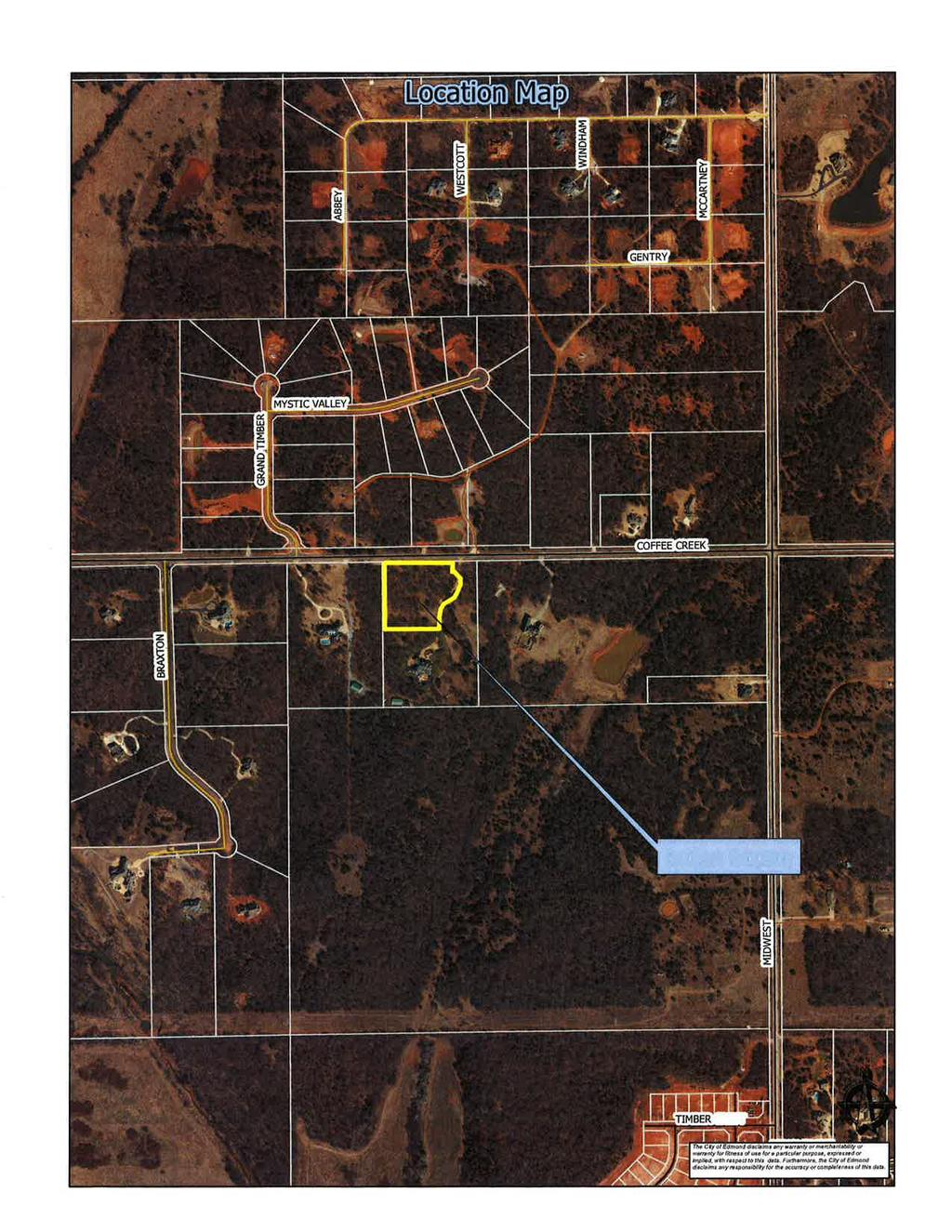
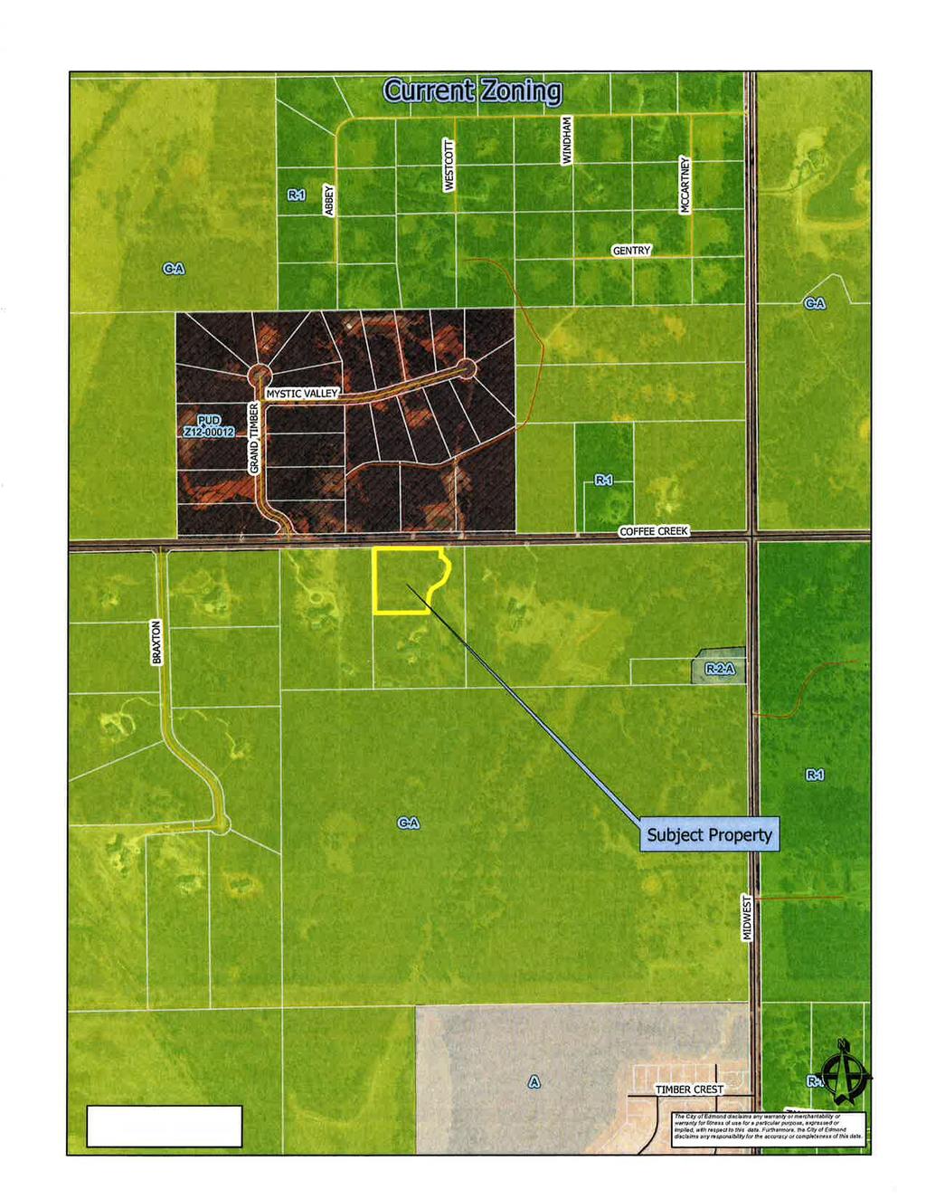
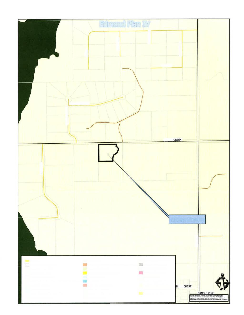
69 Planning Commission 11. Meeting Date: 06/07/2016 From: Bob Schiermeyer Department: Planning/Zoning Information RE: Case #Z Public Hearing and Consideration of Rezoning from G-A General Agricultural to R-1 Rural Estate District, generally located south of Coffee Creek Road, approximately a quarter of a mile west of Midwest Boulevard. (Jill Smith) Mr. and Mrs. Smith own 10 acres of land in east Edmond between Air Depot Boulevard and Midwest Boulevard. There is an existing home on acres, and a new building site on acres is planned in the northwest portion of the property. This is not a private street addition, both parcels would front on Coffee Creek Road and have their own driveways. Each lot would operate with their own water well, septic tank or aerobic system. The property is currently zoned G-A and the Smith family would like to have one new building site. Only 3 acres is being requested for R-1 Rural Estate zoning. This request complies with the Edmond Plan, since there is no public water or sewer near the property and the lot size would be two acres or larger. Smith Rez Attachments
70
71
72
73
74 Planning Commission 12. Meeting Date: 06/07/2016 From: Bob Schiermeyer Department: Planning/Zoning Information RE: Case #PR Public Hearing and Consideration of Preliminary Plat approval for the Highgarden Addition Phase 1 with private streets located a quarter of a mile south of Sorghum Mill Road and east of Douglas Boulevard. (Highgarden Development, LLC) Highgarden development is planning 65 single family homes on 31 acres in the Woodland Park Planned Unit Development. These lots will connect to city water and sewer. The streets will be private. The lot size is generally 75 x 145 for a total of 10,730 square foot lots. The developer has completed a drainage study and plans for a detention pond adjacent to the creek. There are several common areas and the project will be gated. Ninety foot of right-of-way is provided along Douglas Boulevard to meet the Master Transportation Plan. The preliminary plat indicates that there will be several other sections to Highgarden Addition. The Woodland Park PUD identifies a series of greenbelts, one of which that does extend through this addition in the center of the blocks. In the letter from April 25, 2016 the developers engineer indicates that he does not wish to have the greenbelt in the plat. Highgarden Ph1 PP Attachments
75

76
77
78
79
80
EDMOND PLANNING COMMISSION 20 S. Littler, Edmond, Oklahoma Tuesday, May 17, :30 p.m.
 City of Edmond NOTICE OF PUBLIC MEETING The City of Edmond encourages participation from all its citizens. To request an accommodation due to a disability, please allow at least 48 hours prior to the scheduled
EDMOND PLANNING COMMISSION 20 S. Littler, Edmond, Oklahoma Tuesday, May 6, :30 p.m.
 City of Edmond NOTICE OF PUBLIC MEETING The City of Edmond encourages participation from all its citizens. If participation at any Public meeting is not possible due to a disability, notification to the
AGENDA. EDMOND PLANNING COMMISSION 20 S. Littler, Edmond, Oklahoma Tuesday, February 18, :30 p.m. CITY COUNCIL WORKSHOP
 City of Edmond NOTICE OF PUBLIC MEETING The City of Edmond encourages participation from all its citizens. If participation at any Public meeting is not possible due to a disability, notification to the
Planning Commission 16 February 4, 2014 EDMOND PLANNING COMMISSION MEETING. Tuesday, February 4, 2014
 Planning Commission 16 EDMOND PLANNING COMMISSION MEETING Tuesday, 5:30 P.M. The Edmond Planning Commission Meeting was called to order by Chairperson Barry K. Moore at 5:30 p.m., Tuesday,, in the City
EDMOND PLANNING COMMISSION MEETING. Tuesday, October 5, 2004
 124 EDMOND PLANNING COMMISSION MEETING Tuesday, 5:30 P.M. The Edmond Planning Commission Meeting was called to order by Chairperson David Woods at 5:30 p.m., Tuesday,, in the City Council Chambers at 20
EDMOND PLANNING COMMISSION 20 S. Littler, Edmond, Oklahoma Tuesday, July 21, :30 p.m.
 City of Edmond NOTICE OF PUBLIC MEETING The City of Edmond encourages participation from all its citizens. If participation at any Public meeting is not possible due to a disability, notification to the
AGENDA. EDMOND PLANNING COMMISSION 20 S. Littler, Edmond, Oklahoma Tuesday, January 7, :30 p.m. CITY COUNCIL WORKSHOP
 City of Edmond NOTICE OF PUBLIC MEETING The City of Edmond encourages participation from all its citizens. If participation at any Public meeting is not possible due to a disability, notification to the
EDMOND PLANNING COMMISSION 20 S. Littler, Edmond, Oklahoma Tuesday, August 4, :30 p.m.
 City of Edmond NOTICE OF PUBLIC MEETING The City of Edmond encourages participation from all its citizens. If participation at any Public meeting is not possible due to a disability, notification to the
Planning Commission 75 June 3, 2014 EDMOND PLANNING COMMISSION MEETING. Tuesday, June 3, 2014
 Planning Commission 75 EDMOND PLANNING COMMISSION MEETING Tuesday, 5:30 P.M. The Edmond Planning Commission Meeting was called to order by Chairperson Barry K. Moore at 5:30 p.m., Tuesday,, in the City
EDMOND PLANNING COMMISSION MEETING. Tuesday, December 16, 2003
 EDMOND PLANNING COMMISSION MEETING Tuesday, December 16, 2003 5:30 P.M. The Edmond Planning Commission Meeting was called to order by Chairperson David Woods at 5:30 p.m., Tuesday, December 16, 2003, in
Planning Commission 116 August 20, 2013 EDMOND PLANNING COMMISSION MEETING. Tuesday, August 20, 2013
 Planning Commission 116 EDMOND PLANNING COMMISSION MEETING Tuesday, 5:30 P.M. The Edmond Planning Commission Meeting was called to order by Chairperson Barry K. Moore at 5:30 p.m., Tuesday,, in the City
AGENDA. EDMOND PLANNING COMMISSION 20 S. Littler, Edmond, Oklahoma Tuesday, February 21, :30 p.m. CITY COUNCIL WORKSHOP
 City of Edmond NOTICE OF PUBLIC MEETING The City of Edmond encourages participation from all its citizens. If participation at any Public meeting is not possible due to a disability, notification to the
AGENDA. EDMOND PLANNING COMMISSION 20 S. Littler, Edmond, Oklahoma Tuesday, August 6, :30 p.m. CITY COUNCIL WORKSHOP
 City of Edmond NOTICE OF PUBLIC MEETING The City of Edmond encourages participation from all its citizens. If participation at any Public meeting is not possible due to a disability, notification to the
EDMOND PLANNING COMMISSION 20 S. Littler, Edmond, Oklahoma Tuesday, May 22, :30 p.m.
 City of Edmond NOTICE OF PUBLIC MEETING The City of Edmond encourages participation from all its citizens. To request an accommodation due to a disability, please allow at least 48 hours prior to the scheduled
EDMOND PLANNING COMMISSION MEETING. Tuesday, August 22, 2006
 187 EDMOND PLANNING COMMISSION MEETING Tuesday, August 22, 2006 5:30 P.M. The Edmond Planning Commission Meeting was called to order by Chairperson Leroy Cartwright at 5:30 p.m., Tuesday,, in the City
Planning Department Oconee County, Georgia
 Planning Department Oconee County, Georgia STAFF REPORT REZONE CASE #: 6985 DATE: October 31, 2016 STAFF REPORT BY: Andrew C. Stern, Planner APPLICANT NAME: Williams & Associates, Land Planners PC PROPERTY
THE AREA PLAN COMMISSION OF ST. JOSEPH COUNTY, IN AGENDA
 THE AREA PLAN COMMISSION OF ST. JOSEPH COUNTY, IN AGENDA Tuesday, June 20, 2017 Fourth-Floor Council Chambers 3:30 p.m. County-City Building, South Bend, IN PUBLIC HEARINGS: 1. Rezonings: A. A combined
URBANDALE PLANNING AND ZONING COMMISSION MINUTES. November 2, 2015
 URBANDALE PLANNING AND ZONING COMMISSION MINUTES The Urbandale Planning and Zoning Commission met in regular session on Monday,, at the Urbandale City Hall, 3600 86 th Street. Chairperson Julie Roethler
URBANDALE PLANNING AND ZONING COMMISSION MINUTES. July 9, 2018
 URBANDALE PLANNING AND ZONING COMMISSION MINUTES The Urbandale Planning and Zoning Commission met in regular session on Monday,, at the Urbandale City Hall, 3600 86th Street. Chairperson Jeff Hatfield
PLANNED UNIT DEVELOPMENT & SUBDIVISION STAFF REPORT Date: November 17, 2016
 PLANNED UNIT DEVELOPMENT & SUBDIVISION STAFF REPORT Date: November 17, 2016 DEVELOPMENT NAME SUBDIVISION NAME LOCATION Autonation Ford of Mobile Autonation Ford of Mobile Subdivision 901, 909, and 925
SUBDIVISION DESIGN PRINCIPLES AND STANDARDS
 SECTION 15-200 SUBDIVISION DESIGN PRINCIPLES AND STANDARDS 15-201 STREET DESIGN PRINCIPLES 15-201.01 Streets shall generally conform to the collector and major street plan adopted by the Planning Commission
EXHIBIT D. Planned Unit Development Written Description April 13, 2016 Rouen Cove Phase II PUD
 1 EXHIBIT D Planned Unit Development Written Description April 13, 2016 Rouen Cove Phase II PUD Development # 8986.001 Developer: Curtis L. Hart Hart Resources LLC 8051 Tara Lane Jacksonville, Florida
M E M O R A N D U M. Meeting Date: October 23, Item No. F-1. Planning and Zoning Commission. Daniel Turner, Planner I
 M E M O R A N D U M Meeting Date: October 23, 2017 Item No. F-1 To: From: Subject: Planning and Zoning Commission Daniel Turner, Planner I PUBLIC HEARING: Consider a recommendation of a of Planned Development
REPORT TO THE SHELBY COUNTY PLANNING COMMISSION From the Department of Development Services Planning Services. February 4, 2019
 REPORT TO THE SHELBY COUNTY PLANNING COMMISSION From the Department of Development Services Planning Services February 4, 2019 Case No. Request for Rezoning Approval From E-1 to E-2 SD This is a request
McGowin Park, LLC. B-3, Community Business District
 # 10, 11, 12 SUB2014-00024 ZON2014-00500 ZON2014-00501 SUBDIVISION, PLANNED UNIT DEVELOPMENT (East), PLANNED UNIT DEVELOPMENT (West) STAFF REPORT Date: April 3, 2014 DEVELOPMENT NAME LOCATION McGowin Park,
Town of Hamburg Board of Zoning Appeals Meeting November 1, Minutes
 Town of Hamburg Board of Zoning Appeals Meeting November 1, 2016 Minutes The Town of Hamburg Board of Zoning Appeals met for a Regular Meeting on Tuesday, November 1, 2016 at 7:00 P.M. in Room 7B of Hamburg
Town of Cary, North Carolina Rezoning Staff Report 14-REZ-31 Cary Park PDD Amendment (Waterford II) Town Council Meeting January 15, 2015
 Town Council Meeting January 15, 2015") Town of Cary, North Carolina Rezoning Staff Report 14-REZ-31 Cary Park PDD Amendment (Waterford II) Town Council Meeting January 15, 2015 REQUEST To amend the Town of Cary Official Zoning Map by amending
Town of Cary, North Carolina Rezoning Staff Report 14-REZ-31 Cary Park PDD Amendment (Waterford II) Town Council Meeting January 15, 2015 REQUEST To amend the Town of Cary Official Zoning Map by amending
Appendix J - Planned Unit Development (PUD)
") Appendix J - Planned Unit Development (PUD) Intent and Purpose The purpose of the PUD is: 1. To provide development that is consistent with the Comprehensive Land Use Plan and promote the goals and objectives
Appendix J - Planned Unit Development (PUD) Intent and Purpose The purpose of the PUD is: 1. To provide development that is consistent with the Comprehensive Land Use Plan and promote the goals and objectives
ALPINE TOWNSHIP PLANNING COMMISSION REGULAR MEETING June 15, 2017
 Page 1 of 6 ALPINE TOWNSHIP PLANNING COMMISSION REGULAR MEETING 17-26 CALL TO ORDER / APPROVAL OF THE REGULAR MEETING MINUTES OF MAY 18, 2017 AND THE / PUBLIC COMMENT ON NON-AGENDA ITEMS The Alpine Township
SUBDIVISION, PLANNED UNIT DEVELOPMENT, ZONING AMENDMENT, & SIDEWALK WAIVER STAFF REPORT Date: July 19, 2018
 SUBDIVISION, PLANNED UNIT DEVELOPMENT, ZONING AMENDMENT, & SIDEWALK WAIVER STAFF REPORT Date: July 19, 2018 NAME SUBDIVISION NAME LOCATION West Mobile Properties, LLC U.S. Machine Subdivision 556, 566,
PLANNING COMMISSION REPORT Regular Agenda Non Public Hearing Item
 PC Staff Report 3/23/15 FDP-14-00551 Item No. 2-1 PLANNING COMMISSION REPORT Regular Agenda Non Public Hearing Item PC Staff Report 3/23/15 ITEM NO. 2: FINAL DEVELOPMENT PLAN FOR HUTTON FARMS WEST PHASE
ZONING AMENDMENT & PLANNED UNIT DEVELOPMENT STAFF REPORT Date: June 7, 2012
 ZONING AMENDMENT & PLANNED UNIT DEVELOPMENT STAFF REPORT Date: June 7, 2012 NAME DEVELOPMENT NAME LOCATION Mayo Blackmon Mayo Blackmon 1446 Navco Road & 2452 McLaughlin Drive. (North side of McLaughlin
NOTICE OF A REGULAR MEETING OF THE ENID-GARFIELD COUNTY METROPOLITAN AREA PLANNING COMMISSION
 NOTICE OF A REGULAR MEETING OF THE ENID-GARFIELD COUNTY METROPOLITAN AREA PLANNING COMMISSION Notice is hereby given that the Enid-Garfield County Metropolitan Area Planning Commission will meet in regular
Cover Letter with Narrative Statement
 Cover Letter with Narrative Statement March 31, 2017 rev July 27, 2017 RE: Rushton Pointe Residential Planned Unit Development Application for Public Hearing for RPUD Rezone PL2015 000 0306 Mr. Eric Johnson,
PLANNING & DEVELOPMENT
 PLANNING & DEVELOPMENT STAFF REPORT Rezoning PETITION: APPLICANT: PROPERTY OWNER: TYPE OF REQUEST: SIZE OF TRACT: LOCATION: (#17-22) Rezone from A-PUD (Agri-Business Planned Unit Development) to A-PUD
INDIAN RIVER COUNTY, FLORIDA. The Honorable Members of the Planning and Zoning Commission DEPARTMENT HEAD CONCURRENCE
 Public Hearing Legislative INDIAN RIVER COUNTY, FLORIDA M E M O R A N D U M TO: The Honorable Members of the Planning and Zoning Commission DEPARTMENT HEAD CONCURRENCE Robert M. Keating, AICP; Community
ZONING AMENDMENT, PLANNED UNIT DEVELOPMENT & SUBDIVISION STAFF REPORT Date: August 8, 2013
 ZONING AMENDMENT, PLANNED UNIT DEVELOPMENT & SUBDIVISION STAFF REPORT Date: August 8, 2013 NAME SUBDIVISION NAME PV-Magnolia, LLC Twelve Trees Subdivision LOCATION 2860, 2862 and 2866 Pleasant Valley Road
ZONING AMENDMENT & PLANNED UNIT DEVELOPMENT STAFF REPORT Date: July 5, 2012
 ZONING AMENDMENT & PLANNED UNIT DEVELOPMENT STAFF REPORT Date: July 5, 2012 NAME DEVELOPMENT NAME LOCATION Mayo Blackmon Mayo Blackmon 1446 Navco Road & 2452 McLaughlin Drive. (North side of McLaughlin
Planning and Zoning Commission STAFF REPORT REQUEST. DSA : Zone Change from R-3 (Multi-Family Residential) to B-4 (Community Services).
 to B-4 (Community Services).") Planning and Zoning Commission STAFF REPORT AGENDA # TO: FROM: PLANNING AND ZONING COMMISSION Joseph Horn, City Planner MEETING DATES: August 4, 2016 SUBJECT: Gino Tarantini zone change requests REQUEST
Planning and Zoning Commission STAFF REPORT AGENDA # TO: FROM: PLANNING AND ZONING COMMISSION Joseph Horn, City Planner MEETING DATES: August 4, 2016 SUBJECT: Gino Tarantini zone change requests REQUEST
PLANNED UNIT DEVELOPMENT (East), PLANNED UNIT DEVELOPMENT (West) STAFF REPORT Date: September 18, 2014
, PLANNED UNIT DEVELOPMENT (West) STAFF REPORT Date: September 18, 2014") PLANNED UNIT DEVELOPMENT (East), PLANNED UNIT DEVELOPMENT (West) STAFF REPORT Date: September 18, 2014 DEVELOPMENT NAME LOCATION McGowin Park, LLC PLANNED UNIT DEVELOPMENT (East) 1401 Satchel Paige Drive
PLANNED UNIT DEVELOPMENT (East), PLANNED UNIT DEVELOPMENT (West) STAFF REPORT Date: September 18, 2014 DEVELOPMENT NAME LOCATION McGowin Park, LLC PLANNED UNIT DEVELOPMENT (East) 1401 Satchel Paige Drive
Community Development Department 333 Broadalbin Street SW, P.O. Box 490 Albany, OR 97321
 SUMMARY Community Development Department 333 Broadalbin Street SW, P.O. Box 490 Albany, OR 97321 STAFF REPORT Application for Tentative Partition Plat Review Planning File PA-06-17 Phone: 541-917-7550
PLANNING COMMISSION REPORT Regular Agenda Public Hearing Item
 PC Staff Report 11/12/12 Item No. 2B- 1 PLANNING COMMISSION REPORT Regular Agenda Public Hearing Item ITEM NO. 2B: A TO GPI; 110 ACRES; E OF K-10 & N OF W 6 TH ST (MKM) : Consider a request to rezone approximately
CITY OF ALBERT LEA PLANNING COMMISSION ADVISORY BOARD
 CITY OF ALBERT LEA PLANNING COMMISSION ADVISORY BOARD 9/1/2015, 5:30 p.m. City Council Chambers AGENDA A. CALL TO ORDER AND ROLL CALL B. APPROVAL OF THE AGENDA C. APPROVAL OF MINUTES 1. PC Minutes from
Department of Planning & Development Services
 Department of Planning & Development Services S T A F F R E P O R T February 9, 2015 CASE NO: PROJECT: EXECUTIVE SUMMARY: ZA14-154 Plat Revision for Lots 25R-1A, 25R-1B and 25R-1C, Block 1, Woodland Heights
ATTENDING THE MEETING Robert Balogh, Vice-Chairman Sonia Stopperich, Supervisor Marcus Staley, Supervisor Bob Ross, Supervisor
 SPECIAL HEARING - TUESDAY, APRIL 12, 2016 PAGE 1 The North Strabane Township Board of Supervisors held a Special Meeting- Conditional Use Hearing, Tuesday, April 12, 2016, at approximately 6:30 P.M., at
Medical Marijuana Special Exception Use Information
 Medical Marijuana Special Exception Use Information The Special Exception Use information below is a modified version of the Unified Development Code. It clarifies the current section 5:104 Special Exceptions
4.2 RESIDENTIAL ZONING DISTRICTS
 4.2 RESIDENTIAL ZONING DISTRICTS A. Purpose: To define regulations and standards for each residential zoning district in the City. The following sections identify uses, regulations, and performance standards
ARTICLE 23 CONDOMINIUM STANDARDS
 ARTICLE 23 CONDOMINIUM STANDARDS Section 23.01 Intent. The intent of this Article is to provide regulatory standards for condominiums and site condominiums similar to those required for projects developed
Exhibit D. Tallow Ridge PUD. Written Description. Date: January 5, E. City Development Number:
 Exhibit D Tallow Ridge PUD Written Description Date: January 5, 2016 I. SUMMARY DESCRIPTION OF THE PROPERTY A. Current Land Use Designation: RR B. Current Zoning District: PUD C. Requested Zoning District:
ARTICLE 5.0 SCHEDULE OF REGULATIONS
 ARTICLE 5.0 SCHEDULE OF REGULATIONS Section 5.101 Table of Dimensional Standards by District. Dimensional Standards AG AG with sewer Districts Rural Residential Business Other SF SF with sewer R-1 R-1
PLANNING COMMISSION REPORT REGULAR AGENDA
 PP-4-4-11 Item No. 9-1 PLANNING COMMISSION REPORT REGULAR AGENDA PC Staff Report 06/22/11 ITEM NO 9: PRELIMINARY PLAT; KASOLD WATER TOWER ADDITION; SE OF TAM O SHANTER & KASOLD DR (MKM) PP-4-4-11: Consider
PLANNING AND ZONING COMMISSION FEBRUARY 20, :30 P.M. PLANNING AND ZONING MEMBERS PRESENT MEMBERS ABSENT: STAFF PRESENT:
 PLANNING AND ZONING COMMISSION FEBRUARY 20, 2018 5:30 P.M. PLANNING AND ZONING MEMBERS PRESENT Chair Lester Fettig Omar Crisp Paulino Castillo Lydia Alaniz Bryant Ward Jessica Walker Jeremy Langley MEMBERS
Parkland-Spanaway-Midland LUAC - Agenda
 1. 6:30 P.M. Parkland-Spanaway-Midland LUAC - Agenda Documents: 8 2 17 PSMAC Agenda.pdf 2. Parkland-Spanaway-Midland LUAC Initial Project Review Documents: Lincoln Court PP IPR PSMAC-RJ.pdf Department
ADA TOWNSHIP PLANNING COMMISSION MINUTES OF THE MARCH 16, 2006 MEETING
 ADA TOWNSHIP PLANNING COMMISSION MINUTES OF THE MARCH 16, 2006 MEETING A regular meeting of the Ada Township Planning Commission was held on Thursday, March 16, 2006, at the Ada Township Offices, 7330
City of Grande Prairie Development Services Department
 City of Grande Prairie Development Services Department COUNTRYSIDE SOUTH OUTLINE PLAN Prepared by: GPEC Consulting Ltd. #202, 10712-100th Street Grande Prairie, AB Council Resolution of August 20, 2001
Also present were Bill Mann, Senior Planner and Senior Secretary Amber Lehman.
 held Monday, August 26, 2013, at 7:00 P.M. in the Council Chambers, 11 North 3 rd Street, Jacksonville Beach, Florida Call to Order The meeting was called to order by Chairman Greg Sutton. Roll Call Greg
CITY OF PINELLAS PARK, FLORIDA PLANNING AND ZONING COMMISSION MINUTES REGULAR MEETING August 3, 2017
 CITY OF PINELLAS PARK, FLORIDA PLANNING AND ZONING COMMISSION MINUTES REGULAR MEETING August 3, 2017 The meeting was called to order at 7:00 p.m. by Dennis Shelley, Chairperson. ROLL CALL PRESENT: ABSENT:
M E M O R A N D U M. Meeting Date: May 1, Item No. H-4. Steve Polasek, Interim City Manager. David Hawkins, Senior Planner
 M E M O R A N D U M Meeting Date: May 1, 2012 Item No. H-4 To: From: Subject: Steve Polasek, Interim City Manager David Hawkins, Senior Planner PUBLIC HEARING: Consider an ordinance approving a planned
Jaime Pineda. 200 Rayburn Street
 Planning Report File No. 14-10/District 2 Meeting: City Council Date: May 6, 2014 Jaime Pineda 200 Rayburn Street REQUEST Approval of a Specific Use Permit for Contractor Equipment and Storage on a property
Land Use, Transportation, and Infrastructure Committee of Denver City Council FROM: Scott Robinson, Senior City Planner DATE: December 6, 2018 RE:
 Community Planning and Development Planning Services 201 W. Colfax Ave., Dept. 205 Denver, CO 80202 p: 720.865.2915 f: 720.865.3052 www.denvergov.org/cpd TO: Land Use, Transportation, and Infrastructure
ZONING AMENDMENT & SUBDIVISION STAFF REPORT Date: November 3, 2016
 ZONING AMENDMENT & SUBDIVISION STAFF REPORT Date: November 3, 2016 APPLICANT NAME SUBDIVISION NAME David Shumer 5955 Airport Subdivision CITY COUNCIL DISTRICT District 6 5955 Airport Boulevard, 754 Linlen
ARTICLE VI. SUBDIVISION STANDARDS, PUBLIC
 ARTICLE VI. SUBDIVISION STANDARDS, PUBLIC IMPROVEMENTS, AND DESIGN REQUIREMENTS ARTICLE VI. SUBDIVISION STANDARDS, PUBLIC IMPROVEMENTS, AND DESIGN REQUIREMENTS DIVISION 1. GENERAL PROVISIONS Sec. 21-6100.
RP-2, RP-3, RP-4, AND RP-5 PLANNED RESIDENTIAL DISTRICTS
 6.10 - RP-2, RP-3, RP-4, AND RP-5 PLANNED RESIDENTIAL DISTRICTS 6.10.1 GENERAL DESCRIPTION: 6.10.1.1 The regulations established in this Section are intended to provide optional methods of land development
Staff Report: Date: Applicant: Property Identification: Acreage of Request: Current Zoning of Requested Area: Requested Action: Attached:
 Staff Report: Completed by Jeff Palmer Director of Planning & Zoning Date: November 7, 2018, Updated November 20, 2018 Applicant: Greg Smith, Oberer Land Developer agent for Ronald Montgomery ET AL Property
RE: 6. GILL/GREEN COMPREHENSIVE PLAN AMENDMENT, REZONING AND PRELIMINARY PLAT
 commission memo DATE: Thursday - August 9, 2018 TO: Marion Planning & Zoning Commission FROM: David N. Hockett, AICP Principal Planner RE: 6. GILL/GREEN COMPREHENSIVE PLAN AMENDMENT, REZONING AND PRELIMINARY
PLANNED DEVELOPMENT DISTRICT STANDARDS. Cadence Site
 PLANNED DEVELOPMENT DISTRICT STANDARDS Cadence Site A Planned Development District 1. Statement of General Facts, Conditions and Objectives Property Size: Approximately 57.51 Acres York County Tax Map
Section Preliminary Plat Checklist and Application Forms
 Section 201 - Preliminary Plat Checklist and Application Forms PRELIMINARY SUBDIVISION PLAT REVIEW PROCESS CHART PRELIMINARY SUBDIVISION PLAT APPLICATION PRELIMINARY PLAT REVIEW CHECKLIST CITY OF NAMPA
PLANNED UNIT DEVELOPMENT & SUBDIVISION STAFF REPORT August 18, 2016
 PLANNED UNIT DEVELOPMENT & SUBDIVISION STAFF REPORT August 18, 2016 DEVELOPMENT NAME SUBDIVISION NAME Mullinax Ford Subdivision Mullinax Ford Subdivision LOCATION CITY COUNCIL DISTRICT District 6 Southeast
PLANNED UNIT DEVELOPMENT & SUBDIVISION STAFF REPORT Date: July 20, 2017
 PLANNED UNIT DEVELOPMENT & SUBDIVISION STAFF REPORT Date: July 20, 2017 DEVELOPMENT NAME SUBDIVISION NAME LOCATION Rangeline Crossing III Subdivision Rangeline Crossing III Subdivision 5289 Halls Mill
DeWITT CHARTER TOWNSHIP 1401 W. HERBISON ROAD, DeWITT, MI PLANNING COMMISSION MINUTES MONDAY, MARCH 6, 2006
 DeWITT CHARTER TOWNSHIP 1401 W. HERBISON ROAD, DeWITT, MI PLANNING COMMISSION MINUTES MONDAY, MARCH 6, 2006 The regularly scheduled meeting of the DeWitt Charter Township Planning Commission was called
AGENDA PLANNING COMMISSION Tuesday, April 18, :00 PM City Council Chambers 125 East Avenue B, Hutchinson, Kansas
 AGENDA PLANNING COMMISSION Tuesday, April 18, 2017 5:00 PM City Council Chambers 125 East Avenue B, Hutchinson, Kansas 1. ROLL CALL Macklin Woleslagel Bisbee (Chair) Hamilton Peirce Vacant Carr Hornbeck
PLANNING COMMISSION REPORT Regular Agenda Public Hearing Item
 CUP-15-00474 Item No. 5-1 PC Staff Report 11/16/15 ITEM NO. 5 PLANNING COMMISSION REPORT Regular Agenda Public Hearing Item CONDITIONAL USE PERMIT FOR PUBLIC WHOLESALE WATER SUPPLY DISTRICT NO. 25; E 1300
DAUPHIN CREEK ESTATES SUBDIVISION
 # 12 SUB-000076-2017 DAUPHIN CREEK ESTATES SUBDIVISION Engineering Comments: FINAL PLAT COMMENTS (should be addressed prior to submitting the FINAL PLAT for review and/or signature by the City Engineer):
SECTION 10.7 R-PUD (RESIDENTIAL PLANNED UNIT DEVELOPMENT) ZONE
 ZONE") Article X Zones 10-20 SECTION 10.7 R-PUD (RESIDENTIAL PLANNED UNIT DEVELOPMENT) ZONE A. PURPOSE AND INTENT: The R-PUD Residential PUD Zone is intended to provide alternative, voluntary zoning procedures
Article X Zones 10-20 SECTION 10.7 R-PUD (RESIDENTIAL PLANNED UNIT DEVELOPMENT) ZONE A. PURPOSE AND INTENT: The R-PUD Residential PUD Zone is intended to provide alternative, voluntary zoning procedures
Rezoning Petition Zoning Committee Recommendation June 29, 2017
 Rezoning Petition 2017-076 Zoning Committee Recommendation June 29, 2017 REQUEST Current Zoning: MUDD-O (mixed use development, optional) and R-4 (single family residential) Proposed Zoning: UR-2(CD) (urban
NOTICE OF A REGULAR MEETING OF THE ENID-GARFIELD COUNTY METROPOLITAN AREA PLANNING COMMISSION
 NOTICE OF A REGULAR MEETING OF THE ENID-GARFIELD COUNTY METROPOLITAN AREA PLANNING COMMISSION Notice is hereby given that the Enid-Garfield County Metropolitan Area Planning Commission will meet in regular
ELK RAPIDS TOWNSHIP ANTRIM COUNTY, MICHIGAN ORDINANCE NO
 ELK RAPIDS TOWNSHIP ANTRIM COUNTY, MICHIGAN ORDINANCE NO. 3-2011 AN ORDINANCE TO REPLACE THE SUBDIVISION CONTROL ORDINANCE WITH A NEW SUBDIVISION DEVELOPMENT ORDINANCE, IN ACCORD WITH THE LAND DIVISION
M-43 CORRIDOR OVERLAY ZONE
 ARTICLE 26.00 M-43 CORRIDOR OVERLAY ZONE Section 26.01 Findings A primary function of the M-43 state highway is to move traffic through the Township and to points beyond. As the primary east-west arterial
Staff Report: Date: Applicant: Property Identification: Acreage of Request: Current Zoning of Requested Area: Requested Action: Attached:
 Staff Report: Completed by Jeff Palmer Director of Planning & Zoning Date: November 7, 2018 Applicant: Greg Smith, Oberer Land Developer agent for Ronald Montgomery ET AL Property Identification: Frontage
Deerfield Township Community Development Department
 STAFF REVIEW Deerfield Township Community Development Department To: From: Hayfaa Wadih, AICP Lois McKnight, AICP Meeting Date: October 20, 2014 Continued from October 13, 2014 Re: Major PUD Modification
M E M O R A N D U M. Meeting Date: April 19, Item No. H-2. Mark Hafner, City Manager. Michele Berry, Planner II
 M E M O R A N D U M Meeting Date: April 19, 2016 Item No. H-2 To: From: Subject: Mark Hafner, City Manager Michele Berry, Planner II PUBLIC HEARING: Consider an ordinance approving a Specific Use Permit
COUNCIL ACTION FORM. 1. The City Council can approve the Preliminary Plat for Menards Ames Subdivision
 ITEM #: 49 DATE: 03-27-18 COUNCIL ACTION FORM SUBJECT: PRELIMINARY PLAT FOR MENARDS BACKGROUND: Menards Ames Subdivision is a proposed 41-acre development on SE 16 th Street just west of the Skunk River.
Request Conditional Rezoning (R-7.5 Residential to Conditional A-18 Apartment) Staff Recommendation Approval. Staff Planner Jimmy McNamara
 Staff Recommendation Approval. Staff Planner Jimmy McNamara") Applicants Property Owners Baker Villas, LLC; Ocean Rental Properties, LLC; James Edward Sollner; & Linda Susan Sollner Public Hearing November 8, 2017 City Council Election District Kempsville Agenda
Applicants Property Owners Baker Villas, LLC; Ocean Rental Properties, LLC; James Edward Sollner; & Linda Susan Sollner Public Hearing November 8, 2017 City Council Election District Kempsville Agenda
THE AREA PLAN COMMISSION OF ST. JOSEPH COUNTY, IN AGENDA
 THE AREA PLAN COMMISSION OF ST. JOSEPH COUNTY, IN AGENDA Tuesday, January 17, 2017 Fourth-Floor Council Chambers 3:30 p.m. County-City Building, South Bend, IN EXECUTIVE SESSION: A. Election of Officers
PLANNED UNIT DEVELOPMENT & SUBDIVISION STAFF REPORT Date: April 18, 2019
 PLANNED UNIT DEVELOPMENT & SUBDIVISION STAFF REPORT Date: April 18, 2019 DEVELOPMENT NAME SUBDIVISION NAME Springhill Village Subdivision Springhill Village Subdivision LOCATION 4350, 4354, 4356, 4358,
FINAL DRAFT 12/1/16, Rev. to 7/18/17
 FINAL DRAFT 12/1/16, Rev. to 7/18/17 (As Adopted 8/8/17 Effective 9/1/17) SHELTON PLANNING AND ZONING COMMISSION Proposed Amendments to Zoning Regulations I. Amend Section 23 PERMITTED USES by inserting
Community Dev. Coord./Deputy City Recorder
 1 2 3 4 5 6 7 8 9 10 11 12 13 14 15 16 17 18 19 20 21 22 23 24 25 26 27 28 29 30 31 32 33 34 35 36 37 38 39 40 41 42 43 44 45 46 NORTH OGDEN PLANNING COMMISSION MEETING MINUTES December 18, 2013 The North
TOWN OF MINNESOTT BEACH PLANNING BOARD MEETING August 6, 2009
 TOWN OF MINNESOTT BEACH PLANNING BOARD MEETING August 6, 2009 MEMBERS PRESENT: Tim Fowler, Buddy Belangia, Bill Schmidt, Dave Gaskins, and Mac Rubel via telephone. Valerie Calcavecchia arrived after the
ITEM #6 & 6A. Application #LEGP
 CHANGE OF ZONING FROM SR LOW DENSITY SINGLE FAMILY SUBURBAN RESIDENTIAL TO R2/PD LOW TO MODERATE DENSITY RESIDENTIAL/PLANNED DEVELOPMENT AND APPROVAL OF A PRELMINARY DEVELOPMENT PLAN Application #LEGP-001557-2014
LINCOLN COUNTY PLANNING & INSPECTIONS DEPARTMENT
 LINCOLN COUNTY PLANNING & INSPECTIONS DEPARTMENT 302 NORTH ACADEMY STREET, SUITE A, LINCOLNTON, NORTH CAROLINA 28092 704-736-8440 OFFICE 704-736-8434 INSPECTION REQUEST LINE 704-732-9010 FAX To: Board
DEWITT CHARTER TOWNSHIP 1401 W. HERBISON ROAD, DeWITT, MI PLANNING COMMISSION MINUTES MONDAY, APRIL 7, 2008
 DEWITT CHARTER TOWNSHIP 1401 W. HERBISON ROAD, DeWITT, MI PLANNING COMMISSION MINUTES MONDAY, APRIL 7, 2008 The regularly scheduled meeting of the DeWitt Charter Township Planning Commission was called
PLANNED UNIT DEVELOPMENTS
 PLANNED UNIT DEVELOPMENTS SECTION 9.01 DESCRIPTION AND PURPOSE. A. The purpose of a planned unit development (PUD) is to permit greater flexibility in development than is generally possible under standard
May 12, Chapter RH HILLSIDE RESIDENTIAL ZONES REGULATIONS Sections:
 May 12, 2017 Chapter 17.13 RH HILLSIDE RESIDENTIAL ZONES REGULATIONS Sections: 17.13.010 Title, intent, and description. 17.13.020 Required design review process. 17.13.030 Permitted and conditionally
City of Findlay City Planning Commission
 City of Findlay City Planning Commission Thursday, August 9, 2018 9:00 a.m. COMMENTS NEW ITEMS 1. APPLICATION FOR CONDITIONAL USE #CU-05-2018 filed by Terrapin Acquisitions, Ltd., 430 First Street, Findlay
Glades County Staff Report and Recommendation Unified Staff Report for Small Scale Plan Amendment and Rezoning
 Glades County Staff Report and Recommendation Unified Staff Report for Small Scale Plan Amendment and Rezoning CASE NUMBERS: COMP17-02 and RZ17-02 DATE of STAFF REPORT: May 1, 2017 CASE TYPE: Application
Request Modification of Proffers Modification of Conditions (Bulk Storage Yard) Staff Recommendation Approval. Staff Planner Marchelle Coleman
 Staff Recommendation Approval. Staff Planner Marchelle Coleman") Applicant & Property Owner Public Hearing October 10, 2018 City Council Election District Princess Anne Agenda Item 6 Request Modification of Proffers Modification of Conditions (Bulk Storage Yard) Staff
Applicant & Property Owner Public Hearing October 10, 2018 City Council Election District Princess Anne Agenda Item 6 Request Modification of Proffers Modification of Conditions (Bulk Storage Yard) Staff
Washington County, Minnesota Ordinances
 Washington County, Minnesota Ordinances Ordinance No. 153 Text Amendment to the Washington County Development Code - Chapter One, Section 2 and Chapter Two, Part 1, Part 2, Part 3, of the Development Code
PLANNING COMMISSION REPORT REGULAR AGENDA. PC Staff Report 08/25/10 ITEM NO 6: PRELIMINARY PLAT; HALLMARK ADDITION; ACRES; 151 MCDONALD DR (MKM)
") PP-6-6-10 Item No. 6-1 PLANNING COMMISSION REPORT REGULAR AGENDA PC Staff Report 08/25/10 ITEM NO 6: PRELIMINARY PLAT; HALLMARK ADDITION; 5.252 ACRES; 151 MCDONALD DR (MKM) PP-6-6-10: Consider a Preliminary
PP-6-6-10 Item No. 6-1 PLANNING COMMISSION REPORT REGULAR AGENDA PC Staff Report 08/25/10 ITEM NO 6: PRELIMINARY PLAT; HALLMARK ADDITION; 5.252 ACRES; 151 MCDONALD DR (MKM) PP-6-6-10: Consider a Preliminary
NORMAN, OKLAHOMA OWNER: RCB BANK APPLICATION FOR 2025 PLAN CHANGE PLANNED UNIT DEVELOPMENT PRELIMINARY PLAT. 12 December 2011 Revised 5 January 2012
 THE VILLAGE AT OAKHURST ADDITION NORMAN, OKLAHOMA OWNER: RCB BANK APPLICATION FOR 2025 PLAN CHANGE PLANNED UNIT DEVELOPMENT PRELIMINARY PLAT 12 December 2011 Revised 5 January 2012 PREPARED BY: THE RIEGER
SPECIAL ZONING DISTRICTS
 SPECIAL ZONING DISTRICTS 5.01 5.99 RESERVED 5.100 PLANNED DEVELOPMENTS: Purpose: This district is intended to accommodate unified design of residential, commercial, office, professional services, retail