MUNICIPAL-GWINNETT COUNTY PLANNING COMMISSION PUBLIC HEARING AGENDA GWINNETT JUSTICE AND ADMINISTRATION CENTER TUESDAY, MAY 2, 2017 AT 7:00 P.M.
|
|
|
- Jade Wood
- 5 years ago
- Views:
Transcription
1 MUNICIPAL-GWINNETT COUNTY PLANNING COMMISSION PUBLIC HEARING AGENDA GWINNETT JUSTICE AND ADMINISTRATION CENTER TUESDAY, MAY 2, 2017 AT 7:00 P.M. AS SET FORTH IN THE AMERICANS WITH DISABILITIES ACT OF 1992, THE GWINNETT COUNTY GOVERNMENT DOES NOT DISCRIMINATE ON THE BASIS OF DISABILITY AND WILL ASSIST CITIZENS WITH SPECIAL NEEDS GIVEN PROPER NOTICE (SEVEN WORKING DAYS). FOR INFORMATION, PLEASE CALL THE FACILITIES MANAGEMENT DIVISION AT A. CALL TO ORDER, INVOCATION, PLEDGE TO FLAG B. OPENING REMARKS BY CHAIRMAN AND RULES OF ORDER C. APPROVAL OF AGENDA D. APPROVAL OF MINUTES (APRIL 10, 2017 MEETING) E. ANNOUNCEMENTS F. ALTERNATE ARCHITECTURAL DESIGN 1. RACETRAC, 4545 SHACKLEFORD ROAD, PARCEL , ZONED C-2 - PLANNING COMMISSION REVIEW OF ALTERNATE DESIGN OF COMMERCIAL AND NON-RESIDENTIAL CANOPY STRUCTURES, ROOF DESIGN (UDO APPENDIX SECTION 1, SECTION THROUGH AUTHORIZATION BY UDO APPENDIX SECTION 1, SECTION DIRECTOR S REVIEW). DISTRICT (1) BROOKS G. OLD BUSINESS 1. CASE NUMBER :RZC (PUBLIC HEARING HELD) APPLICANT :PEACHTREE HOTEL GROUP, LLC CONTACT :SHANE LANHAM PHONE NUMBER : ZONING CHANGE :R-100 TO C-2 LOCATION :1700 BLOCK OF NORTH BROWN ROAD MAP NUMBER :R ACREAGE :4.43 ACRES SQUARE FEET :76,299 SQUARE FEET PROPOSED DEVELOPMENT :HOTEL (BUFFER REDUCTION) COMMISSION DISTRICT :(1) BROOKS DEPARTMENT RECOMMENDATION :APPROVAL WITH CONDITIONS
2 Planning Commission Agenda May 2, 2017 Page 2 2. CASE NUMBER :RZM (PUBLIC HEARING HELD) APPLICANT :NDI DEVELOPMENT, LLC CONTACT :MATTHEW REEVES PHONE NUMBER : ZONING CHANGE :C-2 TO R-TH LOCATION :4500 BLOCK OF SATELLITE BOULEVARD MAP NUMBERS :R & 225 ACREAGE :4.49 ACRES UNITS :35 UNITS PROPOSED DEVELOPMENT :TOWNHOMES COMMISSION DISTRICT :(1) BROOKS DEPARTMENT RECOMMENDATION :APPROVAL WITH CONDITIONS 3. CASE NUMBER :RZR (PUBLIC HEARING HELD) APPLICANT :MICHAEL J. CASWELL CONTACT :TRACEY D. MASON, ESQ. PHONE NUMBER : ZONING CHANGE :R-100 TO R-75 LOCATION :1400 BLOCK OF AZALEA DRIVE MAP NUMBERS :R & 068 ACREAGE :18.46 ACRES UNITS :49 UNITS PROPOSED DEVELOPMENT :SINGLE-FAMILY SUBDIVISION COMMISSION DISTRICT :(4) HEARD DEPARTMENT RECOMMENDATION :DENIAL 4. CASE NUMBER :CIC (PUBLIC HEARING HELD) APPLICANT :AME ARCHITECT, INC. CONTACT :ABDEL K. ELASSAR PHONE NUMBER : ZONING :O-I LOCATION :800 BLOCK OF BUFORD HIGHWAY MAP NUMBER :R ACREAGE :0.73 ACRE PROPOSED DEVELOPMENT :CHANGE IN CONDITIONS OF ZONING COMMISSION DISTRICT :(1) BROOKS DEPARTMENT RECOMMENDATION :APPROVAL WITH CONDITIONS H. NEW BUSINESS 1. CASE NUMBER :RZC APPLICANT :GEORGIA SENIOR LIVING, LLC CONTACT :MITCH PEEVY PHONE NUMBER : ZONING CHANGE :R-100 TO O-I LOCATION :2500 BLOCK OF MEADOW CHURCH ROAD MAP NUMBERS :R , 174, 013, & 014 ACREAGE :7.68 ACRES SQUARE FEET :181,500 SQUARE FEET PROPOSED DEVELOPMENT :SENIOR LIVING FACILITY (BUFFER REDUCTION) COMMISSION DISTRICT :(1) BROOKS DEPARTMENT RECOMMENDATION :APPROVAL WITH CONDITIONS
3 Planning Commission Agenda May 2, 2017 Page 3 2. CASE NUMBER :SUP APPLICANT :GEORGIA SENIOR LIVING, LLC CONTACT :MITCH PEEVY PHONE NUMBER : ZONING :O-I (PROPOSED) LOCATION :2500 BLOCK OF MEADOW CHURCH ROAD MAP NUMBERS :R , 174, 013, & 014 ACREAGE :7.68 ACRES SQUARE FEET :181,500 SQUARE FEET PROPOSED DEVELOPMENT :BUILDING HEIGHT INCREASE (BUFFER REDUCTION) COMMISSION DISTRICT :(1) BROOKS DEPARTMENT RECOMMENDATION :APPROVAL WITH CONDITIONS 3. CASE NUMBER :SUP APPLICANT :GEORGIA SENIOR LIVING, LLC CONTACT :MITCH PEEVY PHONE NUMBER : ZONING :O-I (PROPOSED) LOCATION :2500 BLOCK OF MEADOW CHURCH ROAD MAP NUMBERS :R , 174, 013, & 014 ACREAGE :7.68 ACRES SQUARE FEET :181,500 SQUARE FEET PROPOSED DEVELOPMENT :SENIOR LIVING FACILITY (BUFFER REDUCTION) COMMISSION DISTRICT :(1) BROOKS DEPARTMENT RECOMMENDATION :APPROVAL WITH CONDITIONS 4. CASE NUMBER APPLICANT CONTACT PHONE NUMBER ZONING CHANGE LOCATION MAP NUMBER ACREAGE UNITS PROPOSED DEVELOPMENT COMMISSION DISTRICT DEPARTMENT RECOMMENDATION :RZM :QUINTUS DEVELOPMENT, LP :KELLY KEAPPLER : :M-1 TO RM-24 :4100 BLOCK OF SATELLITE BOULEVARD :2000 BLOCK OF SATELLITE POINT :INTERSTATE 85 SOUTH :R A :20.12 ACRES :292 UNITS :APARTMENTS :(1) BROOKS :APPROVAL WITH CONDITIONS 5. CASE NUMBER :RZR APPLICANT :JOSE RAMOS CONTACT :ALEJANDRO RAMOS PHONE NUMBER : ZONING CHANGE :RA-200 TO R-100 LOCATION :4800 BLOCK OF SPOUT SPRINGS ROAD :2100 BLOCK OF OLD FLOWERY BRANCH ROAD MAP NUMBER :R ACREAGE :2.44 ACRES UNITS :3 UNITS PROPOSED DEVELOPMENT :SINGLE-FAMILY SUBDIVISION COMMISSION DISTRICT :(3) HUNTER DEPARTMENT RECOMMENDATION :DENIAL
4 Planning Commission Agenda May 2, 2017 Page 4 6. CASE NUMBER :CIC APPLICANT :LOGISTICS & ENGINEERING SOLUTIONS, INC. CONTACT :MICHAEL BONSELL PHONE NUMBER : ZONING :O-R LOCATION :2500 BLOCK OF LOGANVILLE HIGHWAY MAP NUMBER :R ACREAGE :5.48 ACRES PROPOSED DEVELOPMENT :CHANGE IN CONDITIONS OF ZONING COMMISSION DISTRICT :(3) HUNTER DEPARTMENT RECOMMENDATION :APPROVAL WITH CONDITIONS 7. CASE NUMBER :SUP APPLICANT :78 CARWASH LLC CONTACT :RAMESH NAIK PHONE NUMBER : ZONING :C-2 LOCATION :4700 BLOCK OF STONE MOUNTAIN HIGHWAY MAP NUMBER :R6063B008F ACREAGE :1.28 ACRES SQUARE FEET :1,200 SQUARE FEET PROPOSED DEVELOPMENT :AUTOMOBILE SERVICE (RENEWAL) COMMISSION DISTRICT :(2) HOWARD DEPARTMENT RECOMMENDATION :DENIAL 8. CASE NUMBER :SUP APPLICANT :ENTERPRISE LEASING COMPANY OF GEORGIA, LLC CONTACT :R. MATTHEW REEVES, ESQ. PHONE NUMBER : ZONING :M-1 LOCATION :1700 BLOCK OF JEURGENS COURT :5300 BLOCK OF GOSHEN SPRINGS ROAD MAP NUMBER :R ACREAGE :23.55 ACRES SQUARE FEET :128,800 SQUARE FEET PROPOSED DEVELOPMENT :MAINTENANCE SHOP (RENEWAL) COMMISSION DISTRICT :(2) HOWARD DEPARTMENT RECOMMENDATION :APPROVAL WITH CONDITIONS I. AUDIENCE COMMENTS J. COMMITTEE REPORTS K. COMMENTS BY STAFF AND PLANNING COMMISSION L. ADJOURNMENT
5
6
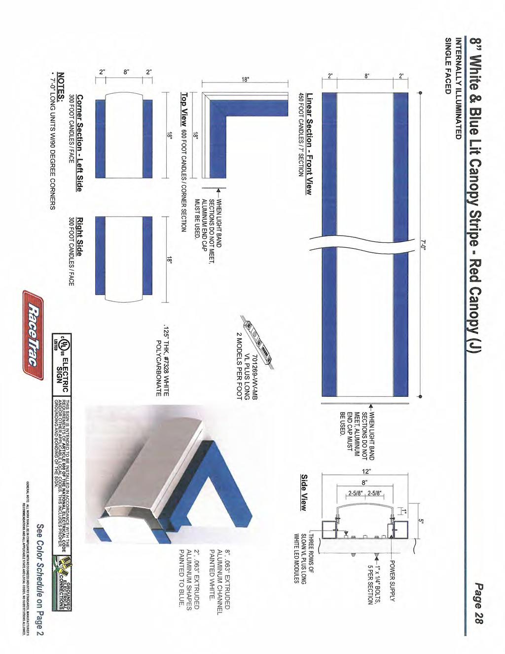
7 55 SF Canopy LED Logo Sign - Red Canopy Page 63 CANOPY LENGTH TBD PER SITE 15'-4 15/16" 4'-0" CENTERED ON VERTICAL DIMENSION GAS CANOPY FRONT ELEVATION CANOPY WIDTH TBD PER SITE CANOPY WIDTH TBD PER SITE 4'-0" 4'-0" LEFT SIDE VIEW - RED CANOPY RIGHT SIDE VIEW - RED CANOPY 8" WHITE STRIPE 2" BLUE STRIPE See Color Schedule on Page 2
8 GWINNETT COUNTY DEPARTMENT OF PLANNING AND DEVELOPMENT REZONING ANALYSIS CASE NUMBER :RZC ZONING CHANGE :R-100 TO C-2 LOCATION :1700 BLOCK OF NORTH BROWN ROAD MAP NUMBER :R ACREAGE :4.43 ACRES SQUARE FEET :76,299 SQUARE FEET PROPOSED DEVELOPMENT :HOTEL (BUFFER REDUCTION) COMMISSION DISTRICT :(1) BROOKS FUTURE DEVELOPMENT MAP: EXISTING/EMERGING SUBURBAN APPLICANT: PEACHTREE HOTEL GROUP, LLC C/O MAHAFFEY PICKENS TUCKER, LLP 1550 N. BROWN ROAD, SUITE 125 LAWRENCEVILLE, GA CONTACT: SHANE LANHAM PHONE: OWNER: MARY VIRGINIA MIMMS 215 SAVANNA ESTATES COURT CANTON, GA DEPARTMENT RECOMMENDATION: APPROVAL WITH CONDITIONS PROJECT DATA: The applicant requests rezoning from R-100 (Single Family Residence District) to C-2 (General Business District) for the development of a 76,299 square foot hotel on 4.43-acres. The site is located on the western side of North Brown Road, just north of its intersection with Sugarloaf Parkway. The property is wooded and undeveloped. The proposed site plan indicates the development would consist of a four story 76,299 square foot hotel with 130 rooms. A total of 137 parking spaces are indicated for the hotel which meets the minimum parking requirements for a development of this size. Access is shown by a single entrance from North Brown Road. The Department notes that a 75-foot wide buffer would be required between the proposed C-2 development and the R-100 zoned property to the north. As part of this request, the applicant proposes elimination of the required buffer adjacent to the northern property line. A detention pond is shown along the western portion of the property adjacent to North Brown Road.
9 RZC (AM) ZONING HISTORY: The subject property has been zoned R-100 since GROUNDWATER RECHARGE AREA: The subject property is not located within an identified Significant Groundwater Recharge Area. WETLANDS INVENTORY: The subject property does not contain areas, streams and/or bodies of water depicted as wetlands on the U.S. Department of Interior, Fish and Wildlife Service National Wetlands Inventory map on file with the Gwinnett Department of Planning and Development. OPEN SPACE AND GREENWAY MASTER PLAN: No comment. DEVELOPMENT REVIEW SECTION COMMENTS: The Buffer, Landscape and Tree Protection Section of the Unified Development Ordinance (Chapter 620) requires a ten-foot wide landscape strip adjacent to all street rights-of-way for non-residential developments. The Buffer, Landscape and Tree Protection Section of the Unified Development Ordinance (Chapter 620) requires submittal and approval of a Tree Preservation and Replacement Plan prepared by a professional landscape architect prior to securing a Land Disturbance or Development permit. Section of the Unified Development Ordinance requires screening of dumpsters and loading/unloading facilities. Parking lots and interior driveways shall be designed in accordance with Chapter 240 of the Unified Development Ordinance. Section of the Unified Development Ordinance requires a 200-foot deceleration lane with a 50-foot taper at each project entrance that proposes access to a Minor Collection Street or Major Thoroughfare. Right-of-way dedication to accommodate the deceleration lane and an 11-foot shoulder is also required. Reduction in length of a deceleration lane requires approval of a Modification by the Development Division; elimination of a deceleration lane requires approval of a Waiver by the Board of Commissioners. Section of the Unified Development Ordinance requires construction of five-foot wide sidewalks along all exterior roadways adjoining the project, and four-foot wide sidewalks adjacent to both sides of all interior public streets (excluding cul-de-sac turnarounds).
10 RZC (AM) Provide a 75-foot natural, undisturbed buffer adjacent to residential zoned property (Unified Development Ordinance Chapter 610, Table and Section ). Section B of the Unified Development Ordinance requires an additional five-foot setback for all structures (parking lots, driveways, detention ponds, retaining walls, etc.) adjacent to required buffers. Section of the Unified Development Ordinance requires submittal of a Specimen Tree Concept Plan and Tree Survey prior to submittal and acceptance of a Development Permit Application. The developer must submit detailed site development plans, including a landscape and tree preservation/replacement plan, for review and approval of the Development Division prior to any construction. Section of the Unified Development Ordinance requires submittal of a Stormwater Management Report for the project prior to obtaining a Land Disturbance or Development Permit. Section B of the Unified Development Ordinance requires that the lowest floor including the basement, of all non-residential building be constructed at an elevation of at least one foot above the 100-year floodplain. This project lies within an Activity Center/Corridor Overlay District, and is subject to all requirements set forth in Chapter 220 of the Unified Development Ordinance. Section E of the Unified Development Ordinance requires that for developments exceeding 7,500 square feet, primary building facades and entrances shall be located no more than 70-feet from public right-of-way, and shall be oriented to the street and shall provide a sidewalk connecting the front entrance to a continuous sidewalk place parallel to the street. STORMWATER REVIEW SECTION COMMENTS: No comment. GWINNETT COUNTY DEPARTMENT OF TRANSPORTATION COMMENTS: North Brown Road is a Major Arterial and 50 feet of right-of-way is required from the centerline, with 60 feet required within 500 feet of a major intersection. Commercial entrances shall be provided to the site per current development regulations. Standard deceleration lane with appropriate taper and adequate right-of-way will be required. The developer shall be limited to one curb cut.
11 RZC (AM) Prior to the issuance of a Development Permit, a sight distance certification shall be provided. Minimum separation from a driveway, public road, or side street shall be provided as specified in the Gwinnett County Unified Development Ordinance. GWINNETT COUNTY ENVIRONMENTAL HEALTH COMMENTS: No comment. GWINNETT COUNTY DEPARTMENT OF WATER RESOURCES COMMENTS: The available utility records show that the subject development is currently in the vicinity of a 12-inch water main located on the northwest right-of-way of North Brown Road. Due to the uncontrollable variables, the Department of Water Resources (DWR) makes no guarantees as to the minimum pressures or volumes available at a specific point within its system. Demands imposed by the proposed development may require reinforcements or extensions of existing water mains. Any cost associated with such required reinforcements or extensions will be the responsibility of the development and will not be provided by this department. The available utility records show that the subject development is currently in the vicinity of a 10-inch sanitary sewer main located approximately 44 feet east of parcel R in the right-of-way of North Brown Road. The subject development is located within the Beaver Ruin service area. There are currently no connection restrictions within this service area. Treatment capacity within this area is presently available on a first come - first serve basis. Demands imposed by the proposed development may require reinforcements or extensions of existing sewer mains. Any cost associated with such required reinforcements or extensions will be the responsibility of the development and will not be provided by this department. Developer shall provide easements for future sewer connection to all locations designated by DWR during plan review. As-built information for this department is dependent upon outside entities to provide record drawings for the utilities. Therefore, this department does not guarantee the accuracy of the information provided. Extensions of the water and/or sanitary sewer systems within the subject development must conform to this department s policies and Gwinnett County s ordinances. Proceeding design, construction, inspection, and final acceptance of the required utilities, service to these utilities would then become available under the applicable utility permit rate schedules.
12 RZC (AM) BUILDING CONSTRUCTION SECTION COMMENTS: Building Plan Review has no objections under the following conditions: 1. The applicant shall submit civil site drawings to Building Plan Review for review and approval. 2. The applicant shall submit architectural, structural, mechanical, electrical and plumbing drawings for each building for review and approval by Building Plan Review. 3. Each building shall comply with the height and area limitations of Table 503 and the fire resistive and horizontal separation requirements of Table 601 and 602 of the 2012 International Building Code with Georgia state amendments based on occupancy group classification, type of construction, and location of each building from property lines and other buildings. 4. Architectural design of the proposed building shall incorporate the requirements of the Gwinnett County Unified Development Ordinance, Architectural Design Standards, Category Upon completion of plan review approvals, the applicant shall obtain a building permit for each building and achieve satisfactory field inspections for issuance of a Certificate of Occupancy. For assistance, you may contact this office at Monday through Friday from the hours of 8:00 a.m. to 5:00 p.m. GWINNETT COUNTY FIRE SERVICES COMMENTS: No comment. DEPARTMENT ANALYSIS: The applicant requests rezoning from R-100 (Single Family Residence District) to C-2 (General Business District) for the development of a 76,299 square foot hotel on 4.43-acres. The site is located on the western side of North Brown Road, just north of its intersection with Sugarloaf Parkway. The property is wooded and undeveloped. The 2030 Unified Plan Future Development Map indicates that the property lies within the Existing/Emerging Suburban Character Area extending along North Brown Road to the Sugarloaf Parkway commercial corridor. The proposed development of the site as a hotel may be beneficial to the corridor and consistent with the overall policies and goals of the 2030 Unified Plan by complementing and supporting the nearby commercial, office and civic uses. The area surrounding the subject site is characterized by commercial, office and single family residential uses along this segment of North Brown Road. The uses within the immediate area consist of hotels, office uses, the Sugarloaf Mills Mall, Infinite Energy Center and single family subdivisions. Adjacent to the north property line is an office building zoned O-I. East across North Brown Road is The Enclave at Stonehaven subdivision, zoned R-ZT. South is Homewood Suites and Hampton Inn zoned O-I and to the west is wooded property which also
13 RZC (AM) contains a cell tower zoned R-100. Several other hotels are located in the area surrounding the Infinite Energy Arena including the Hilton Garden Inn, Courtyard Marriott and a Holiday Inn, located across Interstate I-85. Given the mixture of uses along this segment of North Brown Road, including several existing hotels, and with conditions limiting the use of the property, a hotel use could be appropriate at this location. In conclusion, if developed in accordance with staff s recommended conditions, this request for C-2 zoning may be consistent with the 2030 Unified Plan policies to support and complement nearby commercial and office uses. Therefore, staff recommends APPROVAL WITH CONDITIONS of this request.
14 RZC (AM) PLANNING AND DEVELOPMENT DEPARTMENT RECOMMENDED CONDITIONS Approval as C-2 (General Business District) subject to the following enumerated conditions: 1. To restrict the use of the property as follows: A. Retail, service-commercial, office, and accessory uses. The following uses shall be prohibited: adult bookstores or entertainment automotive parts stores contractors offices emissions inspection stations equipment rental extended stay hotels or motels recovered materials processing facilities smoke shops/novelty stores tattoo parlors taxidermists yard trimmings composting facilities B. Buildings shall be of a brick, stacked stone and/or glass finish on all sides. Final building elevations shall be submitted for review by the Director of Planning and Development. 2. To abide by the following site development considerations: A. Natural vegetation shall remain on the property until the issuance of a development permit. B. Ground signage shall be limited to monument-type sign(s), and shall be subject to review and approval by the Director of Planning & Development. The sign shall include a minimum two-foot high brick or stacked stone base, complementing the building s architectural treatment. The masonry base shall extend at least the full width of the sign cabinet, and the sign cabinet shall be fully recessed and surrounded by the same materials. Ground signage shall not exceed eight feet in height. C. Wall signage shall not exceed the requirements of the Gwinnett County Sign Ordinance, and shall only utilize neutral (non-white earth tone) background colors for the sign cabinet. D. Window signage (signs displayed on the interior or exterior of the business storefront windows) shall be prohibited, except for open/closed signs or signs required by county, state or federal law. Flashing or blinking signs and
15 RZC (AM) exposed neon or LED signs shall be prohibited. Exposed or visible lighting strips mounted on the building or around window frames shall be prohibited. E. Billboards or oversized signs shall be prohibited. F. No tents, canopies, temporary banners, streamers or roping decorated with flags, tinsel, or other similar material shall be displayed, hung, or strung on the site. No decorative balloons or hot-air balloons shall be displayed on the site. Yard and/or bandit signs, sign-walkers and sign-twirlers shall be prohibited. G. Outdoor storage shall be prohibited. H. Dumpsters shall be screened by a 100% opaque brick or stacked stone wall with an opaque metal gate enclosure. Hours of dumpster pick-up shall be limited to between 7:00 am and 7:00 pm. I. Lighting shall be contained in cut-off type luminaries and shall be directed in toward the property so as not to shine directly into adjacent properties or rights-of-way. J. Outdoor loudspeakers shall be prohibited. K. Peddlers and/or parking lot sales shall be prohibited. L. The property owner shall repaint or repair any graffiti or vandalism that occurs on the property within 72 hours.
16 RZC (AM) PLANNING AND DEVELOPMENT DEPARTMENT RECOMMENDATIONS STANDARDS GOVERNING EXERCISE OF ZONING SUITABILITY OF USE The requested rezoning and development of the proposed hotel at this location could be compatible with the established commercial uses and complement the civic uses along the Sugarloaf Parkway corridor. ADVERSE IMPACTS With the recommended conditions, including use restrictions, adverse impacts on surrounding uses could be minimized. REASONABLE ECONOMIC USE AS ZONED The property has a reasonable economic use as currently zoned. IMPACTS ON PUBLIC FACILITIES It is anticipated that there would be additional impacts on public facilities in the form of traffic and utility demand. CONFORMITY WITH POLICIES The 2030 Unified Plan Future Development Map indicates that the property lies within the Existing/Emerging Suburban Character Area. The proposed development of the site as a hotel may be beneficial to the corridor and consistent with the overall policies and goals of the 2030 Unified Plan by complementing and supporting the nearby commercial, office and civic uses. CONDITIONS AFFECTING ZONING The surrounding area contains a mixture of uses including restaurants, the Sugarloaf Mills Mall, the Infinite Energy Arena and Center and several other commercial, office and civic uses. Given the mixture of uses along this segment of North Brown Road, including several existing hotels, and with conditions limiting the use of the property, a hotel use could be appropriate at this location.
17 Gwinnett County Planning Division Rezoning Application Last Updated 2/20 14 REZONING APPLICANT'S RESPONSE STANDARDS GOVERNING THE EXERCISE OF THE ZONING POWER PURSUANT TO REQUIREMENTS OF THE UNIFIED DEVELOPMENT ORDINANCE, THE BOARD OF COMMISSIONERS FINDS THAT THE FOLLOWING STANDARDS ARE RELEVANT IN BALANCING THE INTEREST IN PROMOTING THE PUBLIC HEALTH, SAFETY, MORALITY OR GENERAL WELFARE AGAINST THE RIGHT TO THE UNRESTRICTED USE OF PROPERTY AND SHALL GOVERN THE EXERCISE OF THE ZONING POWER. PLEASE RESPOND TO THE FOLLOWING STANDARDS IN THE SPACE PROVIDED OR USE AN ATTACHMENT AS NECESSARY: (A) WHETHER A PROPOSED REZONING WILL PERMIT A USE THAT IS SUITABLE IN VIEW OF THE USE AND DEVELOPMENT OF ADJACENT AND NEARBY PROPERTY: Please see attached (B) WHETHER A PROPOSED REZONING WILL ADVERSELY AFFECT THE EXISTING USE OR USABILITY OF ADJACENT OR NEARBY PROPERTY: Please see attached (C) WHETHER THE PROPERTY TO BE AFFECTED BY A PROPOSED REZONING HAS REASONABLE ECO~~OMIC USE AS CURRENTLY ZONED: Please see attached (D) WHETHER THE PROPOSED REZONING WILL RESULT IN A USE WHICH WILL OR COULD CAUSE AN EXCESSIVE OR BURDENSOME USE OF EXISTING STREETS, TRANSPORTATION FACILITIES, UTILITIES, OR SCHOOLS: Please see attached (E) WHETHER THE PROPOSED REZONING IS IN CONFORMITY WITH THE POLICY AND INTENT OF THE LAND USE PLAN: Please see attached (F) WHETHER THERE ARE OTHER EXISTING OR CHANGING CONDITIONS AFFECTING THE USE AND DEVELOPMENT OF THE PROPERTY WHICH GIVE SUPPORTING GROUNDS FOR EITHER APPROVAL OR DISAPPROVAL OF THE PROPOSED REZONING: Please see attached 3 RZC ' RECEIVED BY DEC PI nning & Devetopment
18 REZONING APPLICANT'S RESPONSE STANDARDS GOVERNING THE EXERCISE OF THE ZONING POWER (A) (B) (C) (D) (E) (F) Yes, the proposed Rezoning Application will permit a use that is suitable in view of the use and development of adjacent and nearby property. No, the proposed Rezoning Application will not adversely affect the existing use or usabi I ity of any of the nearby properties. Applicant submits that the property does have not reasonable economic use as currently zoned. No, the proposed Rezoning Application will not result in an excessive or burdensome use of the infrastructure systems. Y cs, the proposed Rezoning Application is in conformity with the policy and intent of the Gwinnett County 2030 Unified Plan. Applicant sub1nits that the commercial/retail nature of the area provides additional support of this Application. RZC ' RECEIVED BY DEC f6 Planning & Devtfopment
19 .i\ifatthew P. Benson Gerald Davidson, Jr.* Brian T. Easley Kelly 0. Faber Christopher D. Holbrook Joshua P. Johnson LETTER OF INTENT FOR REZONING APPLICATION OF PEACHTREE HOTEL GROUP, LLC Shane M. Lanham Austen T. Mabe Jeffrey R. Mahaffey Steven A. Pickens Andrew D. Stancil R. Lee Tucker, J r. *Of Counsel The Applicant, Peachtree Hotel Group, LLC, submits this Rezoning Application for the purpose of rezoning to the C-2 zoning classification an approximately 4.43 acre tract (the "Property") located on North Brown Road near its intersection with Sugarloaf Parkway. The Property is currently zoned R The use and development of the Property as R-1 00 is not economically feasible and is not the highest and best use of the Property. It would be impossible to develop and market the Property for use consistent with the R-1 00 zoning in light of its location immediately adjacent to an expanding commercial corridor at a major intersection. The development of the Property as a C-2 development under the guidelines of Gwinnett County is appropriate for the subject tract and is consistent with the surrounding property. The Applicant intends to develop the Propetiy as a limited service, all-suite hotel within the Hilton family of hotels. Applicant also requests a buffer reduction to zero feet along the along the common propetiy lines (southerly and westerly boundaries) with property owned by Gwinnett County (parcel number A) and submits herewith a site plan reflecting the areas which are the subject of this buffer reduction request. The development of the Property in accordance with a C-2 designation provides the appropriate type of zoning within the Sugarloaf Parkway and North Brown Road commercial corridors. The proposed use is consistent with the intent of the zoning ordinance for C-2 use. Sugarloaf Office I I 1550 North Brown Road, Suite 125, La\.vrenceville, Georgi~"'EJVI=Q BY NorthPoint Office II Cicero Drive, Suite 100, Alpharetta, Georgia 3 ~0~r \J -.. TELEPHONE FACSilVIILE ft, W'Nw.mptlawfirm.com ZC DEC f6 Planning & Devtfopment
20 The requested rezoning will have no adverse i1npact on the current or contemplated uses of nearby or surrounding properties. The Applicant and its representatives welcome the opportunity to meet with staff of the Gwinnett County Department of Planning & Development to answer any questions or to address any concerns relating to the matters set forth in this letter or in the Rezoning Application filed herewith. The Applicant respectfully requests your approval of this Application. Respectfully submitted, FE PICKENS TUCKER, LLP RZC ' RECEIVED BY DEC f6 Plsnning & Devtklpment
21 PH ILL IPS a r ch ltect s+cng lnccrs D D b) D D [:J D D [:J D D bj Q f!o~!,:levat I ON HOME~ D D CRE'<" "'~C<'~ _;~:: ~=-_EJ~ HOME N BROWN ROAD LAWRENCEVILLE, GEORGIA PEACHTREE HOTEL GROUP { ~ 1 TIU' j ' I I!'- I :n: ~E ;.~~VATION TWOPERIME'TERPLAZA 5GIIJGLENRIO(;;EORIVE.SUITE430 ATLAN TA.GA30l42 1--HIIIII-'' 1- I Il. IHfl----- rr.:.' 'Fo ~o~ r r-~ r nf -- EXTERIOR ELEVATIONS A-4.1 RZC2D17.0DODI R nlnd0enmber2, 201G Pl nning nd0 iopm fll THE,.... L..._: 1,..fp HT fe." N~ -- -' IL. Ifl 'life~ 1'4.TL..o-.NT.... :-.t..
22
23 7-157 MEADOW CHURCH RD STRAND AVE HARS HAW BOUVIER PL BELLEFONTE A VE GALLARD ST AVE LEGRAND CIR PIERPONT AVE HUNTCREST WAY FOX CHS N BROWN RD CROSS POINTE WAY GLENHAVEN WAY SEVER RD SATELLITE BLVD POTOMAC PL LEBANON RD SUGARLOAF CIR I85N SUGARLOAF PKWY LIBERTY BELL PL FLINTHAVEN CT GRACEHAVEN WAY PL HAVENTREE CT NEWSTONE ST POTO M AC CT CHARTWELL CT MONTI CELLO PL SUM MER HOLL OW LULLWATE R PL TRL WATSONS 7-83 WOODIRON DR SUGARLOAF PKWY BENNINGTON CT SHADWELL WAY SUGARSTONE DR SUGARSTONE CT LULLWATER CT FREEDOM PKWY DISCOVER MILLS CIR 7-82 SUGAR SPRINGS DR I85S RZC Printed: December 5, 2016 SATELLITE DR Feet SU GAR VA L LEY LN

24 DO l:li~sjq 'nl 1 VII l01 ONV1.utro:) WNNIW-> \IJ~!) ':rnja3~m'v1.i.'m.mid ~'v'o'm!>os t avo~ ~ N 1 HHiH lihhh n: I I ir a ", I I H I ~~, /1 :,,!I " II I i! ll I Ill "' I Jll Ill Jlo all :,,, :w: : Ill Ill ~~II I ~ I a:: : 1111 I If II II a:: I a:: : 11/l I a:: ' : ~~:: I II ' 11 1: l\1\ I i!' \ II I II' II II I II II II II' II II \\' II II, II II II I I' I II II II I II H :: If ' :: II II II II I i II II II ~ II I ~... ~ I ~ I I ' I I /ii i II II II II II II II N EB \, l ~ ~~ ~a :li~ ~t 0 z II II II II II II II II II II II II II II II II II II II II II II II II II II II II II I I II II I ll II I II II II ~ 1 11 II II, II II II II II II II II II I II II II II II II II II II II II II II II II II II II II II II II II II II II II!1\,II II II II II II II II 1111 II 1111 II l\ 11 II 1111 II 1111 II 1111 II 1111 II 1111 II II 1111 II I ill II ~ II II II II!LI!\ Jill Ill IJII IJI I t II IJI Ill Ill 1111 IJI V "ll / II t il 1111 t il Ji ll Jll 1111 C) I 1 II Jill I : : ~: I II I II II ;J 1111 ~ 1 11 '' " ttw/g: I II II I I'- ~ u I II I ~J-' I I II N l_j I I \I 'l:,, I II I,, I D
25 N BROWN RD HAVENTREE CT RZC Printed: December 5, Feet
26 OI R100 SATELLITE BLVD RM13 N BROWN RD M2 I85N OI CROSS POINTE WAY FLINTHAVEN CT SUGARLOAF PKWY R HAVENTREE CT GLENHAVEN CV RZT GLENHAVEN WAY MOONHAVEN WAY POTOMAC CT NEWSTONE ST R100 POTOMAC PL C2 BENNINGTON CT SUGARLOAF PKWY OI LIBERTY BELL PL I85S SHADWELL WAY RZC Printed: December 5, Feet R SUGARSTONE CT
27 GWINNETT COUNTY DEPARTMENT OF PLANNING AND DEVELOPMENT REZONING ANALYSIS CASE NUMBER :RZM ZONING CHANGE :C-2 TO R-TH LOCATION :4500 BLOCK OF SATELLITE BOULEVARD MAP NUMBERS :R & 225 ACREAGE :4.49 ACRES UNITS :35 UNITS PROPOSED DEVELOPMENT :TOWNHOMES COMMISSION DISTRICT :(1) BROOKS FUTURE DEVELOPMENT MAP: REGIONAL MIXED-USE APPLICANT: NDI DEVELOPMENT, LLC C/O ANDERSEN, TATE & CARR, PC 1960 SATELLITE BOULEVARD, SUITE 4000 DULUTH, GA CONTACT: MARIAN C. ADEIMY PHONE: OWNER: PARAGON TOWN CENTER, LLC C/O ANDERSEN, TATE & CARR, PC 1960 SATELLITE BOULEVARD, SUITE 4000 DULUTH, GA DEPARTMENT RECOMMENDATION: APPROVAL WITH CONDITIONS PROJECT DATA: The applicant requests rezoning of a 4.49-acre, two-parcel assemblage from C-2 (General Business District) to R-TH (Single Family Residence Townhouse District) to construct a townhouse development. The property is located on the south side of Satellite Boulevard south of its intersection with Hopkins Mill Road. The proposed 35-unit townhome development would result in a net density of 7.95-units per acre. The applicant states that the townhomes would be two to three stories in height and would have two-car garages at minimum. The design of the development proposes access to the garages via alleys, with the front of the townhome units facing one another. According to the letter of intent, the proposed townhome project is to compliment and support the existing Paragon Shopping Center, and allowing the properties to have connectivity with this property as well as to the future Beaver Ruin park site to the south. Stormwater detention is proposed to be located adjacent to the southern property line. The site plan indicates that there is documented flood hazard along the western and southern property lines totaling to 0.09 acres. A 25-foot landscape setback is proposed along the front
28 RZM (AH) of the property along Satellite Boulevard, where a 50-foot setback is required and variance permit approval will be required. Access to the site is proposed from a single entrance driveway along Satellite Boulevard, and an interior driveway access point to the Paragon shopping center to the east. A 40-foot building setback will be provided along the western side of the property, which includes the required 30-foot landscape buffer. A 40-foot building setback is also noted along the southern (rear) property line adjacent to the future park site. ZONING HISTORY: The property has been zoned C-2 since In 2006, a request for a Buffer Reduction from 75 feet to zero feet was approved in conjunction with other C-2 zoned properties to the east and south (BRD ). In 2008, a Special Use Permit was approved allowing a building height increase for a proposed six-story hotel project that was never built (SUP ). In 2014, Special Use Permit approval was granted for outdoor storage and display on the subject site by The Paragon at Satellite shopping center to the east (SUP ). GROUNDWATER RECHARGE AREA: The subject property is not located within an identified Significant Groundwater Recharge Area. WETLANDS INVENTORY: The subject property does not contain areas, streams and/or bodies of water depicted as wetlands on the U.S. Department of Interior, Fish and Wildlife Service National Wetlands Inventory map on file with the Gwinnett Department of Planning and Development. OPEN SPACE AND GREENWAY MASTER PLAN: The property is adjacent to a future park and trail connections may be required at the time of development. In addition, the developer may be required to install a multiuse path on Satellite Boulevard. DEVELOPMENT REVIEW SECTION COMMENTS: The Buffer, Landscape and Tree Protection Section of the Unified Development Ordinance (Chapter 620) requires submittal and approval of a Tree Preservation and Replacement Plan prepared by a professional landscape architect prior to securing a Land Disturbance or Development permit. Section of the Unified Development Ordinance requires screening of dumpsters and loading/unloading facilities. Parking lots and interior driveways shall be designed in accordance with Chapter 240 of the Unified Development Ordinance.
29 RZM (AH) Section of the Unified Development Ordinance requires construction of five-foot wide sidewalks along all exterior roadways adjoining the project, and four-foot wide sidewalks adjacent to both sides of all interior public streets (excluding cul-de-sac turnarounds). The required landscape front setback of 50 feet appears to not be met. The applicant must either revise the site plan, or seek a Variance from the Zoning Board of Appeals. Internal yard requirements. A 20-foot grassed or landscaped strip shall be provided between all buildings and interior driveways/streets (Unified Development Ordinance Section ). Section of the Unified Development Ordinance requires submittal of a Specimen Tree Concept Plan and Tree Survey prior to submittal and acceptance of a Development Permit Application. The developer must submit a concept plan for review and approval of the Development Division prior to submittal and acceptance of a development permit application. The developer must submit a preliminary plat (construction plans), including a grading plan, tree plan, and road/sewer profiles for review and approval of the Development Division prior to any construction. Section of the Unified Development Ordinance requires submittal of a Stormwater Management Report for the project prior to obtaining a Land Disturbance or Development Permit. Section A of the Unified Development Ordinance requires that the lowest floor, including the basement, of all residential building be constructed at an elevation of at least three feet above the 100-year floodplain. Note that all recreation areas, open space and/or common areas (including stormwater detention facility lots) located within the development shall be controlled by a mandatory Property Owner s Association (to include reported bylaws) with responsibility for maintenance, insurance, and taxes for open space areas. The United States Postal Service may require a centralized mail delivery kiosk for this proposed development, replacing individual mail boxes. Mail delivery kiosk must be located outside of right-of-way access easement (if private street). Location and access must be approved by Gwinnett County D.O.T. STORMWATER REVIEW SECTION COMMENTS: No comment.
30 RZM (AH) GWINNETT COUNTY DEPARTMENT OF TRANSPORTATION COMMENTS: Satellite Boulevard is a Major Arterial and 50 feet of right-of-way is required from the centerline, with 60 feet required within 500 feet of a major intersection. The developer shall be limited to one curb cut. The project entrance shall align with opposing roads or driveways in accordance with the Gwinnett County Unified Development Ordinance. GWINNETT COUNTY ENVIRONMENTAL HEALTH COMMENTS: No comment. GWINNETT COUNTY DEPARTMENT OF WATER RESOURCES COMMENTS: The available utility records show that the subject development is currently in the vicinity of a 16-inch water main located on the northwest right-of-way of Satellite Boulevard. Due to the uncontrollable variables, the Department of Water Resources (DWR) makes no guarantees as to the minimum pressures or volumes available at a specific point within its system. Demands imposed by the proposed development may require reinforcements or extensions of existing water mains. Any cost associated with such required reinforcements or extensions will be the responsibility of the development and will not be provided by this department. The available utility records show that the subject development is currently in the vicinity of a 27-inch sanitary sewer main located approximately 96 feet south of parcel R on parcel R and an eight-inch sanitary sewer main located approximately 89 feet north of parcel R in the right-of-way of Satellite Boulevard. The subject development is located within the Beaver Ruin service area. There are currently no connection restrictions within this service area. Treatment capacity within this area is presently available on a first come - first serve basis. Demands imposed by the proposed development may require reinforcements or extensions of existing sewer mains. Any cost associated with such required reinforcements or extensions will be the responsibility of the development and will not be provided by this department. Developer shall provide easements for future sewer connection to all locations designated by DWR during plan review. As-built information for this department is dependent upon outside entities to provide record drawings for the utilities. Therefore, this department does not guarantee the accuracy of the information provided.
31 RZM (AH) Extensions of the water and/or sanitary sewer systems within the subject development must conform to this department s policies and Gwinnett County s ordinances. Proceeding design, construction, inspection, and final acceptance of the required utilities, service to these utilities would then become available under the applicable utility permit rate schedules. BUILDING CONSTRUCTION SECTION COMMENTS: No comment. GWINNETT COUNTY FIRE SERVICES COMMENTS: No comment. DEPARTMENT ANALYSIS: The subject property is located on the southern side of Satellite Boulevard, south of its intersection with Hopkins Mill Road. The property is undeveloped, and has been previously graded and cleared for use as outdoor storage. The applicant is requesting rezoning from C-2 to R-TH for a 35-unit townhome development at a density of 7.95 units per acre. The 2030 Unified Plan Future Development Map indicates the site is located within a Regional Mixed-Use Character Area. Considered the County s most intense mix of commercial, employment and residential developments, this Character Area encourages specifically High and Medium Density residential developments which may include townhouses. The proposed R-TH zoning to allow for a 35 unit townhome project may comply with the 2030 Unified Plan Character Area recommendations. The surrounding area is characterized by commercial/retail uses with multi- and single-family residential development along this segment of Satellite Boulevard. To the north, across Satellite Boulevard is the Hopkins Ridge subdivision, zoned R-TH, and a C-2 property developed with a shopping center. To the north of the shopping center is also R-TH zoned property, which received approval in 2006 for a 34-unit development, but has not been constructed. To the east of the property is the Paragon Shopping Center, with a C-2 zoning, which has already been constructed with a driveway that could connect to the proposed new townhouse development. To the south is vacant property zoned C-2 and owned by the County for future use as Beaver Ruin Park. To the west is residential property zoned R-75 (Single-Family Residence District) developed as part of the Hickory Ridge subdivision. The proposed project would be compatible with the existing development of the area and could act as a transition between the commercial development to the east and single-family residential uses to the west. In conclusion, the proposed townhome development may be consistent with the character of the area and surrounding development, as well as the policies of the 2030 Unified Plan. Therefore, the Department of Planning and Development recommends APPROVAL WITH CONDITIONS of the proposed project.
32 RZM (AH) PLANNING AND DEVELOPMENT DEPARTMENT RECOMMENDED CONDITIONS Approval as R-TH for a townhome development, subject to the following enumerated conditions: 1. To restrict the use of the property as follows: A. Attached townhouse dwellings and accessory uses not to exceed 35 units for a maximum net density of 7.95 units per acre B. Buildings shall be constructed of brick or stacked stone on four sides, with minor treatments (i.e., gables, bay windows, chimneys) of fiber-cement shake or siding. Architectural elevations shall be submitted for review and approval by the Director of Planning and Development. C. The minimum heated floor area per dwelling shall be 1,800 square feet. D. All dwellings shall have at least a double-car garage. All units shall provide sole access via alleys and shall have rear-entry garages. E. A mandatory homeowners association shall be incorporated which provides for building and grounds maintenance, repair, insurance and working capital. Said association must also include declarations and by laws including rules and regulations which shall at minimum regulate and control the following: 1. Exterior home maintenance to include roofing and painting. 2. All grounds and common area maintenance, including detention facilities. 3. Exterior fence maintenance to include the requirement that any graffiti shall be repaired and repainted within 72 hours. 4. Restrictions on single-family residential use only of units. No more than ten percent of the total units may be leased by individual owners at any time. 2. To satisfy the following site development considerations: A. All grassed areas shall be sodded. B. All utilities shall be placed underground. C. The Satellite Boulevard frontage and project entrance shall be landscaped by the developer and maintained by the Homeowner s Association. Entrance shall include a masonry entrance feature. The fence may be constructed as a solid brick or stacked stone wall, or as a wrought iron-style fence with brick or
33 RZM (AH) stacked stone columns (max. 30-feet on-center). Landscape, entrance feature, and fencing plans shall be subject to review and approval of the Director of Planning and Development. D. Natural vegetation shall remain on the property until the issuance of a development permit. 3. To abide by the following requirements, dedications and improvements: A. Dedicate, at no cost to Gwinnett County, all necessary right-of-way and easements for the future construction of the Beaver Ruin Park through the property. Right-of-way/easement width and location shall be located outside of stream bank setbacks and are subject to review and approval by the Gwinnett Department of Community Services.
34 RZM (AH) PLANNING AND DEVELOPMENT DEPARTMENT RECOMMENDATIONS STANDARDS GOVERNING EXERCISE OF ZONING SUITABILITY OF USE The requested rezoning and proposed townhomes could be suitable if the homes are constructed in a manner that compliments and supports the existing Paragon Shopping Center, as conditioned. ADVERSE IMPACTS As conditioned, the construction of townhomes that comply with the architectural and building standards of the Unified Development Ordinance should not adversely impact the surrounding area. REASONABLE ECONOMIC USE AS ZONED The property has a reasonable economic use as currently zoned. IMPACTS ON PUBLIC FACILITIES An increase in the number of school-aged children, traffic, and utility demand would be anticipated from this request. CONFORMITY WITH POLICIES Townhomes could be consistent with the 2030 Unified Plan, which encourages High and Medium Density residential developments within the Regional Mixed-Use character area. CONDITIONS AFFECTING ZONING The proposed townhomes could act as a transition between existing commercial and residential development, and there is existing townhome development approved in the surrounding area.
35 Gwinnett County Planning Division Rezoning Application Last Updated 2/20 14 REZONING APPLICANT'S RESPONSE STANDARDS GOVERNING THE EXERCISE OF THE ZONING POWER PURSUANT TO REQUIREMENTS OF THE UNIFIED DEVELOPMENT ORDINANCE, THE BOARD OF COMMISSIONERS FINDS THAT THE FOLLOWING STANDARDS ARE RELEVANT IN BALANCING THE INTEREST IN PROMOTING THE PUBLIC HEALTH, SAFETY, MORALITY OR GENERAL WELFARE AGAINST THE RIGHT TO THE UNRESTRICTED USE OF PROPERTY AND SHALL GOVERN THE EXERCISE OF THE ZONING POWER. PLEASE RESPOND TO THE FOLLOWING STANDARDS IN THE SPACE PROVIDED OR USE AN ATTACHMENT AS NECESSARY: (A) WHETHER A PROPOSED REZONING WILL PERMIT A USE THAT IS SUITABLE IN VIEW OF THE USE AND DEVELOPMENT OF ADJACENT AND NEARBY PROPERTY: See Exhibit "B" (B) WHETHER A PROPOSED REZONING WILL ADVERSELY AFFECT THE EXISTING USE OR USABILITY OF ADJACENT OR NEARBY PROPERTY: See Exhibit "B" (C) WHETHER THE PROPERTY TO BE AFFECTED BY A PROPOSED REZONING HAS REASONABLE ECONOMIC USE AS CURRENTLY ZONED: See Exhibit "B" (D) WHETHER THE PROPOSED REZONING WILL RESULT IN A USE WHICH WILL OR COULD CAUSE AN EXCESSIVE OR BURDENSOME USE OF EXISTING STREETS, TRANSPORTATION FACILITIES, UTILITIES, OR SCHOOLS: See Exhibit "B" (E) WHETHER THE PROPOSED REZONING IS IN CONFORMITY WITH THE POLICY AND INTENT OF THE LAND USE PLAN: See Exhibit "B" (F) WHETHER THERE ARE OTHER EXISTING OR CHANGING CONDITIONS AFFECTING THE USE AND DEVELOPMENT OF THE PROPERTY WHICH GIVE SUPPORTING GROUNDS FOR EITHER APPROVAL OR DISAPPROVAL OF THE PROPOSED REZONING: See Exhibit "B" 3 DEC Planomg & Devlklpment RZM '1700 2
36 APPLICANT S RESPONSES IN SUPPORT PARAGON - RZM A) WHETHER A PROPOSED REZONING WILL PERMIT A USE THAT IS SUITABLE IN VIEW OF THE USE AND DEVELOPMENT OF ADJACENT AND NEARBY PROPERTY: Yes. The proposed development would be entirely consistent with the adjacent and nearby property uses, which are a mixture of commercial, office and residential uses, as well as other high-density attached residential apartment uses located in the vicinity of the subject property in the Satellite Blvd. corridor. The introduction of residential options will provide new customers for existing restaurant and commercial uses in this area. B) WHETHER THE PROPOSED REZONING WILL ADVERSELY AFFECT THE EXISTING USE OR USEABILITY OF ADJACENT OR NEARBY PROPERTY: No, this request proposes a development that is entirely compatible with the adjoining and nearby properties and will not adversely affect these properties. New residential and senior options will provide a much needed base of new customers for the numerous commercial and restaurant uses in the area, energizing the existing commercial base. The subject Property has remained vacant and is surrounded by existing and more intense commercial uses, two major arterial roads with access to I-85. The proposed development provides a less-intense, transitional use to nearby residential uses and further insulates those uses from the potential of a more intense commercial use on this property. C) WHETHER THE PROPERTY TO BE AFFECTED BY THE PROPOSED SPECIAL USE PERMIT HAS A REASONABLE ECONOMIC USE AS CURRENTLY ZONED: No. There is no current or foreseeable future market demand for the subject property and no reasonable economic use under the subject property s current zoning, especially due to the over-saturation of commercial development in the area. D) WHETHER THE PROPOSED REZONING WILL RESULT IN A USE WHICH WILL OR COULD CAUSE AN EXCESSIVE OR BURDENSOME USE OF EXISTING STREETS, TRANSPORTATION FACILITIES, UTILITIES, OR SCHOOLS: No, this property is located in an area with public water and sewer availability, and convenient access to major thoroughfares and near a major interstate highway interchange. This rezoning will not cause excessive use of
37 existing streets, transportation facilities or utilities and since the residential component of the proposed development will be marketed towards and designed primarily to serve young professionals, empty-nesters and seniors, and there will be little if any impact on the schools. E) WHETHER THE PROPOSED REZONING IS IN CONFORMITY WITH THE POLICY AND INTENT OF THE LAND USE PLAN: Yes. The Gwinnett 2030 Unified Plan has designated the I-85 corridor as well as the specific area within which this property is located for office, residential developments, making this request entirely consistent with the Plan s guidelines for this area. F) WHETHER THERE ARE OTHER EXISTING OR CHANGING CONDITIONS AFFECTING THE USE AND DEVELOPMENT OF THE PROPERTY WHICH GIVE SUPPORTING GROUNDS FOR EITHER THE APPROVAL OR DISAPPROVAL OF THE PROPOSED REZONING. Yes. The property has been zoned for more intense uses and has remained vacant. The proposed uses will address the needs and improve property values in the area. The 2030 Unified Plan has designated the I-85 corridor as well as the specific area within which this property is located for higher density residential development, making this request entirely consistent with the Plan s guidelines for this area _1.DOC
38 ANDERSEN I TATE I CARR ANDERSEN, TATE & CARR, P. C. ONE SUGARLOAF CENTRE 1960 SATELLITE BOULEVARD, SUITE 4000 DULUTH, GEORGIA (770) FACSIMILE: (770) www. atclawfirm. com MARIAN C. ADEIMY Attorney at Law VIA HAND-DELIVERY AND Gwinnett County Department of Planning and Development 446 West Crogan Street, Suite 225 Lawrenceville, Georgia December 2, madeimy@atclawfirm. com R~c~IVEoay DEc P!ann;,g & De lltkjpmefw LETTER OF INTENT NDI DEVELOPMENT, LLC (Tow nhomes at Paragon) REQUEST FOR REZONING FROM C-2 TO R-TH Satellite Blvd., Duluth, GA RZM '170oz Dear Planning staff: The Applicant, NDI Development, LLC (hereinafter, "Applicant"), submits this request to rezone the property located near Satellite Blvd. and Indian Trail Road, Duluth, GA, from C-2 to R-TH, for a 35 unit townhome development on the approximately 4.5 acre site adjacent to the Paragon shopping center (hereinafter, the "Property"). I. Rezoning Plan: The proposed townhomes would include larger, open floor plans, high-end materials and finishes, and two - three stories in height. They will include a minimum two-car garage. The proposed townhome use would complement and support the existing Paragon shopping center. While Paragon currently contains some retail and restaurant options, there is no residential option for young professionals and empty-nesters to support the existing retail center and convenient location the Property offers. The Property is also located near a future Gwinnett County park, which could serve as an amenity and connection to the larger, future mixed-use development. On the whole, Gwinnett County has very few upscale developments which include office, commercial and residential options. This underserved market of young professionals is exactly the sort of demographic that Gwinnett needs to attract to maintain its vibrancy. Similarly, the County has residents looking to downsize as empty nesters. The introduction of a quality townhomes at this location will introduce new customers for the restaurants and commercial uses already in this area, energize the commercial base and make those existing businesses and restaurants even more viable. The future of the 1-85 corridor depends on the influx of active community members who will gravitate to our project and are exactly the demographic that can bring new vitality to Gwinnett.
39 Letter of Intent NDI/Paragon December 2, 2016 Page 2 Moreover, the Gwinnett 2030 Unified Plan has designated the specific area within which this property is located as a commercial corridor, for higher density residential and mixed-use developments, making this townhome request entirely consistent with the Plan's guidelines for this area. The property has access to a public water supply, public sanitary sewer, and convenient access to collector streets, major thoroughfares and an interstate highway. The subject property is also located near primary and easily accessible transportation routes. II. Constitutional Objections In order to preserve their constitutional objections, the Applicant and Owner outline those potential objections herein. The portions of the Gwinnett County Unified Development Ordinance, as amended, (the "UDO") which classify or condition the Subject Property into any more or less intensive zon ing classification and/or zoning conditions other than as requested by the Applicant and property owner are and would be unconstitutional in that they would destroy the Applicant's and Property Owner's property rights without first paying fair, adequate and just compensation for such rights, in violation of Article I, Section I, Paragraph II of the Constitution of the State of Georgia of 1983, the Equal Protection and Due Process Clause of the Fourteenth Amendment to the Constitution of the United States. A refusal by the Gwinnett County Board of Commissioners to approve the Applicant's and Property Owner's requested rezoning request and related variances, with only such additional conditions as agreed to by the Applicant, so as to permit the only feasible economic use of the Subject Property, would be unconstitutional and discriminate in an arbitrary, capricious and unreasonable manner between the Applicant and owners of similarly situated property in violation of Article I, Section I, Paragraph II of the Constitution of the State of Georgia of 1983 and the Due Process and Equal Protection Clause of the Fourteenth Amendment to the Constitution. A denial of the requested rezoning will deny the Applicant and Property Owner an economically viable use of the Property while not substantially advancing legitimate state and County interests. The Applicant and its representatives welcome the opportunity to meet with the staff of the Gwinnett County Department of Planning and Development to answer any questions or to address any concerns. Applicant respectfully requests your approval of this Application. Respectfully submitted, ANDERSEN, TATE & CARR, P.C. Marian C. Adeimy Attorney for the Applicant/Paragon Town Center Enclosures (Application packet) cc: Lisa Reeves Taylor Anderson RECEIVED BY DEC Pfsnning & De_,pment film '11 Oo e
40 Residential Rezoning Impact on Local Schools Prepared for Gwinnett County, February 2017 Case # Schools Current Projections Proposed Zoning Approximate additional Student Forecast Capacity Over/Under Forecast Capacity Over/Under Forecast Capacity Over/Under Projections from Proposed Developments RZM Norcross HS ,600 1, ,600 1, ,600 1, Summerour MS , , , Beaver Ridge ES , , , RZM Parkview HS , , , Trickum MS , , , Mountain Park ES Current projections do not include new developments GCPS Planning Department /20/2017

41 - ~ co 0 ~ w '._.) () -J..J..::l w N C\.1 0 " C> 0 ed ['- cr 0: 0 -._. :e c:= e... ~ Q::

42
43 6-240 GLENWHITE DR HIGH FORE ST DR MUIRFIELD ROYAL DR RA CQU ET CT MASTERS CT W AY BIRDIE BOGIE RD LN PLAYER CT CALUMET CIR POND RD ARNOLD PALMER WAY JACK NICKLAUS ST TIGER BLVD INGRAM RD PAR CIR FAIRWAY RD HOPKINS MILL RD FAIRWAY VIEW CT L A KE HOPKINS LAKE DR CREEK FORD TRCE C REEK FORD FOR D CIR D R MONTGOMERY WAY HOPKINS MILL LN HOPKINS TER HOPKINS RUN DR AMELIA CT HOPKINS CREEK DR RIDGE BROOK TRL OA KN O LL CIR SATELLITE BLVD PRE STON PARK DR W LIDDELL RD SATELLITE PTE I85N REDFIELD DR RANCH TRL M USTA NG DR GREEN ST FAIRWAY CIR SIERRA CT WESLEY CT R UNNIN G SITTING BULL CT FOX TRL VINEY ARD POND DR APPALOOSA INDIAN TRAIL LILBURN RD TRL BEAVER SPUR CT SPRINGS LN CASTOR DR RZM Printed: December 6, 2016 GREENWAY RD RED OAK RD SOURWOOD RD SOURWOOD TER Feet I R BOLT O N C WILLOW TRAIL PKWY HILLCREST RD OLD MILL WAY VALL EY RIDGE VALLEY RIDGE DR NORCROSS BEAVER LN R IDGE CIR I85S TIMMERS WAY SHACKELFORD CT MECA WAY PARK DR BEAVER RUIN RD DOAN WAY SHACKLEFORD RD COMM UNICATIONS DR INTERNATIONAL CT INTERNATIONAL BLVD CORPORATE DR STEVE REYNOLDS BLVD 6-184
44
45 HOPKINS MILL RD SATELLITE BLVD RZM Printed: December 6, Feet
46 RA200 PAR CIR LAKE FORD CIR R60 M1 RZT HOPKINS MILL RD FAIRWAY RD FAIRWAY CIR MONTGOMERY TRL RTH RM13 POND RD SIERRA CT SATELLITE BLVD R75 OLD MILL WAY C2 VALLEY RIDGE LN BEAVER RUIN PARK SITE BIG HICKORY TRL GREENWAY RD VALLEY RIDGE DR I85S I85N BEAVER RUIN RD M SOURWOOD RD OI RZM Printed: December 6, 2016 C Feet M1 NORCROSS BEAVER RIDGE CIR M SHACKLEFORD RD
47 GWINNETT COUNTY DEPARTMENT OF PLANNING AND DEVELOPMENT REZONING ANALYSIS CASE NUMBER :RZR ZONING CHANGE :R-100 TO R-75 LOCATION :1400 BLOCK OF AZALEA DRIVE MAP NUMBERS :R & 068 ACREAGE :18.46 ACRES UNITS :49 UNITS PROPOSED DEVELOPMENT :SINGLE-FAMILY SUBDIVISION COMMISSION DISTRICT :(4) HEARD FUTURE DEVELOPMENT MAP: EXISTING/EMERGING SUBURBAN APPLICANT: MICHAEL J. CASWELL 1911 GRAYSON HIGHWAY SUITE GRAYSON, GA CONTACT: TRACEY D. MASON, ESQ. PHONE: OWNERS: OTIS P. & SANDRA JONES PO BOX 304 LAWRENCEVILLE, GA DEPARTMENT RECOMMENDATION: DENIAL PROJECT DATA: The applicant requests the rezoning of an acre parcel from R-100 (Single-family Residence District) to R-75 (Single-family Residence District) to construct a 49-lot single-family subdivision. The subject property is located on the west side of Azalea Drive, north of Braselton Highway. The majority of the property is wooded; with a small portion of the property along the road that is open, where a house was previously located. The property is surrounded on three sides by homes on large lots. The submitted site plan shows 49 lots on acres, resulting in a density of 2.65 units per acre. The development would be accessed by a single entrance/exit onto Azalea Drive. A stream is identified on the site plan along with an associated 50-foot undisturbed stream buffer and 75-foot impervious setback. Staff notes there is a single detention pond to address site drainage, located in the center of the property adjacent to the existing stream. The minimum lot size for the proposed lots is 10,500 square feet, with a 1,200 square foot minimum dwelling size for each of the detached residences. The applicant has not indicated what materials would be used on the exterior of the homes.
48 RZR (AM) ZONING HISTORY: The property has been zoned R-100 since GROUNDWATER RECHARGE AREA: The subject property is not located within an identified Significant Groundwater Recharge Area. WETLANDS INVENTORY: The subject property does not contain areas, streams and/or bodies of water depicted as wetlands on the U.S. Department of Interior, Fish and Wildlife Service National Wetlands Inventory map on file with the Gwinnett Department of Planning and Development. OPEN SPACE AND GREENWAY MASTER PLAN: No comment. DEVELOPMENT REVIEW SECTION COMMENTS: The Buffer, Landscape and Tree Protection Section of the Unified Development Ordinance (Chapter 620) requires a no-access easement along the line of double frontage lots abutting upon a major thoroughfare for residential developments. The Buffer, Landscape and Tree Protection Section of the Unified Development Ordinance (Chapter 620) requires submittal and approval of a Tree Preservation and Replacement Plan prepared by a professional landscape architect prior to securing a Land Disturbance or Development permit. Section of the Unified Development Ordinance requires a 200-foot deceleration lane with a 50-foot taper at each project entrance that proposes access to a Minor Collection Street or Major Thoroughfare. Right-of-way dedication to accommodate the deceleration lane and an 11-foot shoulder is also required. Reduction in length of a deceleration lane requires approval of a Modification by the Development Division; elimination of a deceleration lane requires approval of a Waiver by the Board of Commissioners. Section of the Unified Development Ordinance requires construction of five-foot wide sidewalks along all exterior roadways adjoining the project, and four-foot wide sidewalks adjacent to both sides of all interior public streets (excluding cul-de-sac turnarounds). Section of the Unified Development Ordinance requires submittal of a Specimen Tree Concept Plan and Tree Survey prior to submittal and acceptance of a Development Permit Application.
49 RZR (AM) The developer must submit a preliminary plat (construction plans), including a grading plan, tree plan, and road/sewer profiles for review and approval of the Development Division prior to any construction. Section of the Unified Development Ordinance requires submittal of a Stormwater Management Report for the project prior to obtaining a Land Disturbance or Development Permit. Section A of the Unified Development Ordinance requires that the lowest floor, including the basement, of all residential building be constructed at an elevation of at least three feet above the 100-year floodplain. Note that all recreation areas, open space and/or common areas (including stormwater detention facility lots) located within the development shall be controlled by a mandatory Property Owner s Association (to include reported bylaws) with responsibility for maintenance, insurance, and taxes for open space areas. The United States Postal Service may require a centralized mail delivery kiosk for this proposed development, replacing individual mail boxes. Mail delivery kiosk must be located outside of right-of-way access easement (if private street). Location and access must be approved by Gwinnett County D.O.T. STORMWATER REVIEW SECTION COMMENTS: No comment. GWINNETT COUNTY DEPARTMENT OF TRANSPORTATION COMMENTS: Azalea Drive is a Minor Collector and 30 feet of right-of-way is required from the centerline. Standard deceleration lane with appropriate taper and adequate right-of-way will be required. The developer shall be limited to one curb cut. The project entrance shall align with opposing roads or driveways in accordance with the Gwinnett County Unified Development Ordinance. Prior to the issuance of a Development Permit, a sight distance certification shall be provided. GWINNETT COUNTY ENVIRONMENTAL HEALTH COMMENTS: No comment.
50 RZR (AM) GWINNETT COUNTY DEPARTMENT OF WATER RESOURCES COMMENTS: The available utility records show that the subject development is currently in the vicinity of an eight-inch water main located on the northeast right-of-way of Azalea Drive. Due to the uncontrollable variables, the Department of Water Resources (DWR) makes no guarantees as to the minimum pressures or volumes available at a specific point within its system. Demands imposed by the proposed development may require reinforcements or extensions of existing water mains. Any cost associated with such required reinforcements or extensions will be the responsibility of the development and will not be provided by this department. The available utility records show that the subject development is currently in the vicinity of an eight-inch sanitary sewer main located approximately 46 feet west of parcel R on parcel R The subject development is located within the Alcovy Pump service area. There are currently no connection restrictions within this service area. Treatment capacity within this area is presently available on a first come - first serve basis. Demands imposed by the proposed development may require reinforcements or extensions of existing sewer mains. Any cost associated with such required reinforcements or extensions will be the responsibility of the development and will not be provided by this department. Developer shall provide easements for future sewer connection to all locations designated by DWR during plan review. As-built information for this department is dependent upon outside entities to provide record drawings for the utilities. Therefore, this department does not guarantee the accuracy of the information provided. Extensions of the water and/or sanitary sewer systems within the subject development must conform to this department s policies and Gwinnett County s ordinances. Proceeding design, construction, inspection, and final acceptance of the required utilities, service to these utilities would then become available under the applicable utility permit rate schedules. BUILDING CONSTRUCTION SECTION COMMENTS: No comment. GWINNETT COUNTY FIRE SERVICES COMMENTS: No comment.
51 RZR (AM) DEPARTMENT ANALYSIS: The subject property is located on the west side of Azalea Drive, north of Braselton Highway. The applicant requests the rezoning of an acre parcel from R-100 (Single-family Residence District) to R-75 (Single-family Residence District) to construct a 49-lot single-family subdivision. The majority of the property is wooded; with a small portion of the property along the road that is open, where a house was previously located. The property is surrounded on three sides by homes on large lots. The 2030 Unified Plan Future Development Map indicates the property is located within an Existing/Emerging Suburban Character Area. Policies of the Unified Plan for this character area encourage residential in-fill developments with densities and character compatible with existing single-family developments. The proposed rezoning is not supported by these policies of the Unified Plan, as the neighboring single-family homes along Azalea Drive are zoned R-100, and are developed with single homes on large lots as opposed to the subdivision proposed by the applicant. The surrounding area is characterized by residentially zoned land. Properties along Azalea Drive are zoned for single-family residential and developed with single homes on larger lots. Located to the north, east and south of the proposed project are single homes on large lots zoned R-100. To the west is the Park at Glenns Ridge subdivision zoned R-100 CSO accessed via Ridge Road. Subdivisions in the surrounding area are zoned R-100 CSO, R-75, R-75 Modified, and R-100 Modified and are accessed from Ridge Road, Braselton Highway or Old Fountain Road. Although there are other subdivisions in the immediate area, none of these subdivisions are accessed from Azalea Drive along this segment of the road between Ridge Road and Braselton Highway. The density of development proposed by the applicant would not be consistent with the existing density along Azalea Drive. This segment of Azalea Drive contains 34 homes on roughly 148 acres. The development proposed would more than double the amount of homes along Azalea Drive from 34 to 83, with 49 of the homes being on acres. The requested R-75 zoning may not be considered compatible with the existing zoning of the adjoining properties along Azalea Drive. In conclusion, the requested R-75 zoning may not be considered consistent with policies of the Unified Plan and could adversely affect established single-family homes along Azalea Drive, through the introduction of incompatible lot sizes and densities of development. Therefore, staff recommends DENIAL of this petition.
52 RZR (AM) PLANNING AND DEVELOPMENT DEPARTMENT RECOMMENDED CONDITIONS Note: The following conditions are provided as a guide should the Board choose to approve the request. Approval as R-75 (Single Family Residence District) for a Single Family Subdivision, subject to the following enumerated conditions: 1. To restrict the use of the property as follows: A. Single-family detached dwellings and accessory uses and structures. B. The minimum heated floor area per dwelling unit shall be 2,200 square feet for one story homes and 2,400 square feet for two story homes. C. Homes shall be constructed with three sides of brick and/or stacked stone. The balance of the home may be the same or of fiber-cement shake or siding with a three-foot brick or stone water table. D. All dwellings shall have at least a double-car garage. 2. To satisfy the following site development considerations: A. The Azalea Drive street frontage shall be landscaped by the developer and maintained by the Homeowner s Association, and shall include a decorative masonry entrance feature. Landscape and entrance plans shall be subject to review and approval of the Director of Planning and Development. B. Direct lot access to Azalea Drive shall be prohibited. C. All grassed areas on dwelling lots shall be sodded. D. Provide underground utilities throughout the development. E. Natural vegetation shall remain on the property until the issuance of a subdivision development permit. F. Building lots shall not be located within the required stream buffer or impervious setback area.
53 RZR (AM) PLANNING AND DEVELOPMENT DEPARTMENT RECOMMENDATIONS STANDARDS GOVERNING EXERCISE OF THE ZONING SUITABILITY OF USE In light of the development pattern along Azalea Drive, which consists of individual homes on large lots, the 49 lot subdivision proposed by the applicant may not be suitable at this location. ADVERSE IMPACTS Adverse impacts on neighboring properties could be anticipated from the introduction of an incompatible zoning classification, density and lot dimension standard. REASONABLE ECONOMIC USE AS ZONED The property has a reasonable economic use as currently zoned. IMPACTS ON PUBLIC FACILITIES An increase in traffic, utilities usage, stormwater runoff, and the number of school-aged children could be anticipated from this request. CONFORMITY WITH POLICIES The 2030 Unified Plan Future Development Map indicates the property is located within an Existing/Emerging Suburban Character Area. Policies of the Unified Plan for this character area encourage residential in-fill developments with densities and character compatible with existing single-family developments. The proposed rezoning is not supported by these policies of the Unified Plan, as the neighboring single-family homes along Azalea Drive are zoned R-100, and are developed with single homes on large lots as opposed to the subdivision proposed by the applicant. CONDITIONS AFFECTING ZONING The proposed density of this development is not consistent with the low density development of single homes on acreage along Azalea Drive.
54 Gwinnett County Planning Division Rezoning Application Last Updated 12/20 IS REZONING APPLICANT'S RESPONSE STANDARDS GOVERNING THE EXERCISE OF THE ZONING POWER PURSUANT TO REQUIREMENTS OF THE UNIFIED DEVELOPMENT ORDINANCE, THE BOARD OF COMMISSIONERS FINDS THAT THE FOLLOWING STANDARDS ARE RELEVANT IN BALANCING THE INTEREST IN PROMOTING THE PUBLIC HEALTH, SAFETY, MORALITY OR GENERAL WELFARE AGAINST THE RIGHT TO THE UNRESTRICTED USE OF PROPERTY AND SHALL GOVERN THE EXERCISE OF THE ZONING POWER. PLEASE RESPOND TO THE FOLLOWING STANDARDS IN THE SPACE PROVIDED OR USE AN ATTACHMENT AS NECESSARY: (A) (B) WHETHER A PROPOSED REZONING WILL PERMIT A USE THAT IS SUITABLE IN VIEW OF THE USE AND DEVELOPMENT OF ADJACENT AND NEARBY PROPERTY: 7l~<. ~ee ~ l, WHETHER A PROPOSED REZONING WILL ADVERSELY AFFECT THE EXISTING USE OR USABILITY OF ADJACENT OR NEARBY PROPERTY:.., (C) WHETHER THE PROPERTY TO BE AFFECTED BY A PROPOSED REZONING HAS REASONABLE ECONOMIC USE AS CURRENTLY ZONED:.., (D) WHETHER THE PROPOSED REZONING WILL RESULT IN A USE WHICH WILL OR COULD CAUSE AN EXCESSIVE OR BURDENSOME USE OF EXISTING STREETS, TRANSPORTATION FACILITIES, UTILITIES, OR SCHOOLS: (E) WHETHER THE PROPOSED REZONING IS IN CONFORMITY WITH THE POLICY AND INTENT OF THE LAND USE PLAN:." (F) WHETHER THERE ARE OTHER EXISTING OR CHANGING CONDITIONS AFFECTING THE USE AND DEVELOPMENT OF THE PROPERTY WHICH GIVE SUPPORTING GROUNDS FOR EITHER APPROVAL OR DISAPPROVAL OF THE PROPOSED REZONING: JAN 0 5 Z017 P~ & oevelopment 3

55 REZONING APPLICANT'S RESPONSE STANDARDS GOVERNING THE EXERCISE OF THE ZONING POWER REZONING APPLICATION OF MICHAEL J. CASWELL A. WHETHER THE PROPOSED REZONING WILL PERMIT A USE THAT IS SUITABLE IN VIEW OF THE USE AND DEVELOPMENT OF ADJACENT AND NEARBY PROPERTY: In view of the residential nature of this area and, more specifically, the RlOO CSO which abuts this property to the rear, we submit that an R-75 single family detached neighborhood would be appropriate at this location. B. WHETHER THE ZONING PROPOSAL WOULD ADVERSELY AFFECT THE EXISTING USE OR USABILITY OF ADJACENT OR NEARBY PROPERTY. This neighborhood of single family homes would not interfere with the use of the surrounding residential properties. C. WHETHER THE PROPERTY TO BE AFFECTED BY THE ZONING PROPOSAL HAS A REASONABLE ECONOMIC USE AS CURRENTLY ZONED. We submit that the highest and best use of this property would be to be developed for residential use as an R-7 5 neighborhood. D. WHETHER THE PROPOSED REZONING WILL RESULT IN A USE WHICH WLL OR COULD CAUSE AN EXCESSIVE OR BURDENSOME USE OF EXISTING STREETS, TRANSPORTATION FACILITIES, UTILITIES, OR SCHOOLS. The development of this property as a residential single family neighborhood at 2.65 units per acre would not cause an excessive use of the existing streets, transportation facilities. Sanitary sewer is available at the rear of the property, at The Park at Glenns Ridge, Unit Two. It is our understanding that this school district has the capacity to accommodate the additional students who might reside here. E. WHETHER THE PROPOSED REZONING IS IN CONFORMITY WITH THE POLICY AND INTENT OF THE LAND USE PLAN. The intent of the Land Use Plan is for this area to be zoned for detached single-family residential neighborhood, comparable to our proposal. F. WHETHER THERE ARE OTHER EXISTING OR CHANGING CONDITIONS AFFECTING THE USE AND DEVELOPMENT OF THE PROPERTY WHICH GIVE SUPPORTING GROUNDS FOR EITHER APPROVAL OR DISAPPROVAL OF THE ZONING PROPOSAL. A. s per acre, we submit that this rezoning proposal is comparable to ex1sting and anticipated development in the surrounding area. JAN 0 5 LUll p~ & Development
56 LETTER OF INTENT REZONING APPLICATION OF MICHAEL J. CASWELL January 5, 2017 Gwinnett County Department of Planning and Development One Justice Square 446 West Crogan Street Lawrenceville, GA Re: Rezoning Application of Michael J. Caswell, concerning acres located in the 7th Land District, Land Lot 53, Parcel Numbers 009 and 068, located at 1434 Azalea Drive in Gwinnett County, Georgia Dear Planning Department: I am writing to you on behalf of Michael J. Caswell, the Applicant in the abovereferenced case, to respectfully request your approval to rezone the subject property tor- 75 (Single-Family Residence District) to allow for the development of a single family detached neighborhood. We are proposing to build 49 homes on this property, which would result in a gross and net density of 2.65 units per acre. We furthermore propose that each home contain a minimum of 1,200 square feet. This Applicant has a tradition of developing quality neighborhoods in and around Gwinnett County and is committed to continuing that tradition with another successful community here. We see this rezoning request to be suitable in view of the use and development of nearby properties, and, therefore, respectfully request your approval of this proposed rezoning. We are available to meet with you at your convenience to discuss any questions or concerns that you may have. Respectfully submitted, RECE\VEOBY cc: Michael J. Caswell JAN 0 5 ZU1/ p~ & Oevelopment r ichael J. Caswell, the licant RZR 1 17 UO 5
57 Residential Rezoning Impact on Local Schools Prepared for Gwinnett County, February 2017 Case # Schools Current Projections Proposed Zoning Approximate additional Student Forecast Capacity Over/Under Forecast Capacity Over/Under Forecast Capacity Over/Under Projections from Proposed Developments RZR Parkview HS , , , Trickum MS , , , Mountain Park ES RZR Mountain View HS , , , Twin Rivers MS , , , Woodward Mill ES 970 1, , , Current projections do not include new developments GCPS Planning Department /7/2017
58 7-91 TRL B EN T BROOK E 7-92 LOB LOLL STRAW VALLEY RD Y WAY PINYON PL 7-62 CREEK POINTE CIR OAK MOSS DR KELVIN DR BUFORD DR FOUR OAKS LN FOX HOLW SACKETTS DR SPRING HOLW T H E PINDER C LITTLE FAWN CIR IR POINT DR BRANCH RIDGEDALE DR DEER RUN RD TEAL DR 7-64 TREE WAY T E A L CT HOLLYHAWK WAY MACY CT HIGHLAND OAK S WAY AZALEA WOODS DR MACY LN PARK KNOLL CT AZALEA BRO OK DR COUNTRY WALK TRL PARK HOLLOW WAY 7-53 RIDGE HOLLOW LN 7-63 RIDGE RD HILLSIDE BEND XING BAILEY FA R MS DR STON EY MILL POINTE CT 7-54 AZALEA DR FIELD PL JOSH VALLEY BRASELTON HWY LN W PROSPECT BROWN RIDGE LN DR JESSICA LN R D PROSPECT CHURCH OLD FOUNTAIN RD 7-55 MISTWATER TRCE PROSPECT CREEK DR FOUNTAIN HEAD CT PROSPECT RD FOUNTAIN LAKES DR RUSSELL RD RIDGEWOOD PL WHITEHALL DR LOGGINS TRL 7-52 ARNOLD DR PARK HOLLOW LN CEDARSHIRE WAY PINE LN VILLAGE OAKS GATEWOOD DR LN NATHAN MAULDIN DR AR TH UR DR 7-25 GRACE HAD AWAY L N HADAWAY CT ADAH LN FOUNTAIN OAKS CT CEDARS RD C E DAR O AK LN KIMWOOD CT CALVIN 7-51 DAVIS CIR RZR Printed: January 10, 2017 WILDCAT DR HILLCREST WAY LAUREN CIR Feet NORWALK CV GUNTER CIR MEALOR RD HICKORY NUT LN SANDALWOOD DR BAY BERRY LN HADAWAY TRL ARTHUR CT HADA LN HADA CT HIG HFIE L D D R 7-15
59 ' fo ~~ : :;:.:~;~ :~ ~ ~~ SC.tLE tlfs ~~~='----'=='=T 50' R/ W 1 TYPICAL LOT a- M.... ~ ll(_ tji~lt.l t'! ~- i~~ - A 274.l.)' R i' C..lH I!i' ~1"21i 6 " ( '" Ol.IJU ~ IA.U ~oll. :n. 1-il!l l ZCH..Lll IOO SHEET I OF I RECE;VEOBY JAf\J 0 5 Z017 PJ&noiog & De opment RZR '
60 AZALEA DR RZR Printed: January 10, Feet
61 RICHMOND HILL CT STONEY FIELD PL R100 MACY CT R75 MACY LN R100MOD 7-63 HILLSIDE BEND XING HIDDEN POND CIR R100MOD JOSH VALLEY LN C1 W PROSPECT DR 7-64 MILL POINTE CT RA200 RIDGE RD PARK KNOLL TRL COUNTRY WALK CT 7-54 COUNTRY WALK TRL R PARK HOLLOW WAY BRASELTON HWY OI WHITEHALL DR 7-53 R100CSO AZALEA DR R100 OI RA ARNOLD DR LOGGINS TRL CEDARSHIRE WAY RZR Printed: January 10, 2017 PARK HOLLOW LN Feet PINE LN PINE LN R100 GATEWOOD DR R75MOD NATHAN MAULDIN DR 7-26 OLD FOUNTAIN RD 7-25 R75 ARTHUR DR
62 GWINNETT COUNTY DEPARTMENT OF PLANNING AND DEVELOPMENT CHANGE IN CONDITIONS ANALYSIS CASE NUMBER :CIC ZONING :O-I LOCATION :800 BLOCK OF BUFORD HIGHWAY MAP NUMBERS :R ACREAGE :0.73 ACRE PROPOSAL :CHANGE IN CONDITIONS OF ZONING COMMISSION DISTRICT :(1) BROOKS FUTURE DEVELOPMENT MAP: EXISTING/EMERGING SUBURBAN APPLICANT: AME ARCHITECT, INC. C/O ABDEL ELASSAR 500 SUN VALLEY DRIVE, SUITE A & D ROSWELL, GA CONTACT: ABDEL K. ELASSAR PHONE: OWNER: VINCENT DUTA 2100 RIVERSIDE PARKWAY LAWRENCEVILLE, GA DEPARTMENT RECOMMENDATION: APPROVAL WITH CONDITIONS CHANGE IN CONDITIONS SUMMARY: The applicant requests a Change-in-Conditions of a previous 2002 zoning case (RZC ) to amend conditions of zoning pertaining to the overall development of the subject property to allow a Place of Worship. The property is located along the north side of Buford Highway, between Woodward Mill Road and Old Suwanee Road, and is zoned C-2 (General Business District). Currently, the property consists of a single-family dwelling and accessory structures. Condition 1.A. of RZC restricts the use of the property as follows: 1.A. Office and accessory uses, which may include a contractor s office. Through the Change-in-Conditions request, the applicant is requesting to amend the condition of zoning to eliminate the restriction limiting the use of the property to allow for a Place of Worship. Condition 1.B. of RZC requires the occupant to comply with the current building code as related to business occupancy. 1.B. Bring the structure up to code for business occupancy.
63 CIC (TH) The applicant is requesting to amend the current condition of zoning which limits the use of the property for business occupancy only. The applicant intends to occupy the existing structure for assembly related purposes. Therefore, all items related to the Compliance Inspection Report (CIR ) must be satisfied prior to the issuance of a building permit. Condition 1.C. of RZC requires the occupant to obtain a development permit for a contractor s office and reads as follows: 1.C. Submit for a development permit for the contractor s office and complete all required site improvements. As previously stated, the applicant intends to utilize property as a Place of Worship. Therefore, the applicant is requesting to amend the current condition of zoning by eliminating the term contractor s office. The 2030 Unified Plan Future Development Map indicates the site is located within an Existing/Emerging Suburban Character Area. A primary goal of this character area is to accommodate the extensive needs of the surrounding residential neighborhoods. The property was rezoned O-I allowing a contractor s office, with development process being initiated but never completed. The site has remained idle for several years and allowing a less intense use, such as a Place of Worship, would be compatible with recommendations of the 2030 Unified Plan. The surrounding area consists of a mix of commercial, industrial, institutional, and residential uses scattered along the Buford Highway corridor. The area immediately surrounding the property consist of residential single-family dwellings on large lots, Lanier High School, automobile sales and service facilities, as well as other undeveloped properties zoned both C-2 and M-1. The conditions of the previous rezoning that restricted the use of the subject property were incorporated to ensure land use compatibility with the mix of uses in the immediate area. With appropriate conditions, this request would be compatible with nearby and adjacent zoning and uses. In conclusion, the requested Change-in-Conditions and the proposed less intense use of the property would be consistent with the recommendations of the 2030 Unified Plan and surrounding commercial, industrial, institutional, and residential uses in the immediate area. Therefore, the Department of Planning and Development recommends APPROVAL WITH CONDITIONS of this request. ZONING HISTORY: The subject property has been zoned R-75 (Single-Family Residence District) since In 2002 the subject property was zoned O-I (Office Institutional District), pursuant to RZC
64 CIC (TH) GROUNDWATER RECHARGE AREA: The subject property is not located within an identified Significant Groundwater Recharge Area. WETLANDS INVENTORY: The subject property does not contain areas, streams and/or bodies of water depicted as wetlands on the U.S. Department of Interior, Fish and Wildlife Service National Wetlands Inventory map on file with the Gwinnett Department of Planning and Development. OPEN SPACE AND GREENWAY MASTER PLAN: No comment. DEVELOPMENT REVIEW SECTION COMMENTS: The Buffer, Landscape and Tree Protection Section of the Unified Development Ordinance (Chapter 620) requires a ten-foot wide landscape strip adjacent to all street rights-of-way for non-residential developments. The Buffer, Landscape and Tree Protection Section of the Unified Development Ordinance (Chapter 620) requires submittal and approval of a Tree Preservation and Replacement Plan prepared by a professional landscape architect prior to securing a Land Disturbance or Development permit. Section of the Unified Development Ordinance requires screening of dumpsters and loading/unloading facilities as per the architectural design standards. Parking lots and interior driveways shall be designed in accordance with Chapter 240 of the Unified Development Ordinance. Project access and required improvements along State routes or U.S. Highways (i.e., number and design of driveways, deceleration lanes, median breaks, etc.) will be subject to review and approval of the Georgia Department of Transportation. (Section F of the Unified Development Ordinance). Section of the Unified Development Ordinance requires construction of five-foot wide sidewalks along all exterior roadways adjoining the project, and four-foot wide sidewalks adjacent to both sides of all interior public streets (excluding cul-de-sac turnarounds). The required rear setback of 25 feet appears to not be met. The applicant must either revise the site plan, or seek a Variance from the Zoning Board of Appeals. Provide a 50-foot natural, undisturbed buffer adjacent to R-75 zoned properties (Unified Development Ordinance Chapter 610, Table and Section ). 3
65 CIC (TH) Section B of the Unified Development Ordinance requires an additional five-foot setback for all structures (parking lots, driveways, detention ponds, retaining walls, etc.) adjacent to required buffers. Section of the Unified Development Ordinance requires submittal of a Specimen Tree Concept Plan and Tree Survey prior to submittal and acceptance of a Development Permit Application. The developer must submit detailed site development plans, including a landscape and tree preservation/replacement plan, for review and approval of the Development Division prior to any construction. Section of the Unified Development Ordinance requires submittal of a Stormwater Management Report for the project prior to obtaining a Land Disturbance or Development Permit. Section B of the Unified Development Ordinance requires that the lowest floor including the basement, of all non-residential building be constructed at an elevation of at least one foot above the 100-year floodplain. STORMWATER REVIEW SECTION COMMENTS: No comment. GWINNETT COUNTY DEPARTMENT OF TRANSPORTATION COMMENTS: SR 13 Buford Highway is a State Route and Georgia D.O.T. right-of-way requirements govern. GWINNETT COUNTY ENVIRONMENTAL HEALTH COMMENTS: No comment. GWINNETT COUNTY DEPARTMENT OF WATER RESOURCES COMMENTS: The available utility records show that the subject development is currently in the vicinity of a 16-inch water main located on the southeast right-of-way of Buford Highway. The available utility records show that the subject development is currently in the vicinity of an eight-inch sanitary sewer main located approximately 1,588 feet northeast of parcel R in the right-of-way of Secret Cove Drive and an eight-inch sanitary sewer main located approximately 1,159 feet southeast of parcel R on parcel R
66 CIC (TH) BUILDING CONSTRUCTION SECTION COMMENTS: Building Plan Review has no objections under the following conditions: 1. The applicant shall submit architectural, structural, mechanical, electrical and plumbing drawings for any proposed interior tenant space modifications or exterior modifications for review and approval by Building Plan Review. 2. Upon completion of plan review approvals, the applicant shall obtain a building permit for any proposed modification/renovation work and achieve satisfactory field inspections for issuance of a Certificate of Occupancy. For assistance, you may contact this office at Monday through Friday from the hours of 8:00 a.m. to 5:00 p.m. GWINNETT COUNTY FIRE SERVICES COMMENTS: Fire Plan review has no objections to the above Planning Commission request submission, however a change in occupancy classification from Business to Assembly will require plans to be submitted for review prior to occupancy, the plans may be required to be designed by a State of Georgia Licensed Registered Architect. Additional Code based requirements specific to an Assembly occupancy may be required at time of plan submission and review. For assistance, you may contact our office at (678) , Monday through Friday, from the hours of 8:00 a.m. to 5:00 p.m. 5
67 CIC (TH) PLANNING AND DEVELOPMENT DEPARTMENT RECOMMENDED CONDITIONS Approval as C-2 subject to the following enumerated conditions: Change in Conditions of RZC with: Additions in bold Deletions in strikethrough 1. To restrict the use of the property as follows: A. Office, Institutional, and accessory uses, which may include a contractor s office. B. Bring the structure up to code for business occupancy. B. Submit for a development permit for the contractor s office and complete all required site improvements. Obtain all necessary development and building permits, and bring the site and structure(s) up to all applicable zoning, development and building codes within 180 days of zoning approval. C. Any new construction shall have an exterior of brick, and/or stacked stone, or stucco and be residential in nature. Final building elevations shall be submitted for review by the Director of Planning and Development. D. Outdoor storage shall be prohibited. not be allowed without approval of a Special Use Permit. 2. To satisfy the following site development considerations: A. The buffer adjacent to residential zoning along the eastern and western property lines may be replaced by a 10-foot wide landscaped strip including preservation of existing trees. B. Provide 40-foot wide planted evergreen buffer adjacent to the northern property line. No intrusions into the buffer area shall be permitted other than existing encroachments. C. Provide a 10-foot wide landscape strip along Buford Highway. D. Dumpsters shall be screened by a 100% opaque fence or wall at least six (6) feet in height. E. Lighting shall be contained in cut-off type luminaries and shall be directed in toward the property so as not to shine directly into adjacent or nearby residential properties. 6
68 CIC (TH) F. Ground signage shall be limited to a single monument ground sign with a stone base, matching the exterior of the residence, a maximum of 6-feet in height. G. Billboards shall be prohibited. 7
69 CIC (TH) PLANNING AND DEVELOPMENT DEPARTMENT RECOMMENDATIONS STANDARDS GOVERNING THE EXERCISE OF ZONING SUITABILITY OF USE The requested Change-in-Conditions to allow a less intense use of the property would be suitable in light of adjacent and nearby uses and zoning within the immediate area. ADVERSE IMPACTS With the recommended conditions, potential impacts on adjacent and nearby properties would be reduced. REASONABLE ECONOMIC USE AS ZONED The subject property has a reasonable economic use as currently zoned. IMPACT ON PUBLIC FACILITIES An increase in traffic, utility demand, and stormwater run-off could be anticipated from development of the property as proposed. CONFORMITY WITH POLICIES With the recommended conditions, the request would be generally consistent with zoning actions taken by the Board related to other Places of Worship throughout the county, and the policies of the 2030 Unified Plan recommending compatibility of residential uses in the area. CONDITIONS AFFECTING ZONING The majority of properties located along this segment of Buford Highway include a wide range of commercial, industrial, institutional, and residential use permitted under current Gwinnett County regulations. Allowing the change to the conditions of zoning for a Place of Worship would not directly affect the established development pattern in the immediate area. 8

70 Gwinnett County Planning Division Change in Conditions Application Last Updated 12/2015 CHANGE IN CONDITIONS APPLICANT'S RESPONSE STANDARDS GOVERNING THE EXERCISE OF THE ZONING POWER PURSUANT TO REQUIREMENTS OF THE UNIFIED DEVELOPMENT ORDINANCE, THE BOARD OF COMMISSIONERS FINDS THAT THE FOLLOWING STANDARDS ARE RELEVANT IN BALANCING THE INTEREST IN PROMOTING THE PUBLIC HEALTH, SAFETY, MORALITY OR GENERAL WELFARE AGAINST THE RIGHT TO THE UNRESTRICTED USE OF PROPERTY AND SHALL GOVERN THE EXERCISE OF THE ZONING POWER. PLEASE RESPOND TO THE FOLLOWING STANDARDS IN THE SPACE PROVIDED OR USE AN ATTACHMENT AS NECESSARY: (A) (B) WHETHER A PROPOSED CHANGE IN CONDITIONS WILL PERMIT A USE THAT IS SUITABLE IN VIEW OF THE USE AND DEVELOPMENT OF ADJACENT AND NEARBY PROPERTY: s~e />t 1ic1-1eJ fy.1s wew 5H!IL WHETHER A PROPOSED CHANGE IN CONDITIONS WILL ADVERSELY AFFECT THE EXISTING USE OR USABILITY OF ADJACENT OR NEARBY PROPERTY: 5et A~C!J!) A rj(,~!h SHuT (C) WHETHER THE PROPERTY TO BE AFFECTED BY A PROPOSED CHANGE IN CONDITIONS HAS REASONABLE ECONOMIC USE AS CU ENTLY ZONED: \.J. c (D) WHETHER THE PROPOSED CHANGE IN CONDITIONS WILL RESULT IN A USE WHICH WILL OR COULD CAUSE AN EXCESSIVE OR BURDENSOME USE OF EXISTING STREETS, TRANSPORTATION FACILITIES, UTILITIES, OR SCHOOLS: > 4',,.. rft>c ti!!) A~IJ Vtn s /lt1at (E) (F) WHETHER THE PROPOSED CHANGE IN CONDITIONS IS IN CONFORMITY WITH THE POLICY AND INTENT OF THE LAND USE PLAN: 5(!f.f 7f!J-C /,/~ ~('IS WfY'l 5 /,4@. WHETHER THERE ARE OTHER EXISTING OR CHANGING CONDITIONS AFFECTING THE USE AND DEVELOPMENT OF THE PROPERTY WHICH GIVE SUPPORTING GROUNDS FOR EITHER APPROVAL OR DISAPPROVAL OF THE PROPOSED CHANGE IN CONDITIONS:.5 ~ ~ 1[1:-tj{t/,A r/5 w'~}'i s Huf RECEIVED BY FEB Planning & Development 3 CIC '1701 2
71 Change in Conditions Applicant's Response Answer for: Standards Governing Exercise of the Zoning Power A. The GRC religious center is a non-profit organization and religious group which supports surrounding societies for all faiths and beliefs. They provide educational materials to the community, as well as fill full spiritual guidance. Pla ce of Worship Facilities such as the GRC has become an integral part of any neighborhood society. B. The Current use of the property is: construction contractor offices. The proposed project use is a Place of worship has much less negative impact than the previously granted use to construction contractor offices. There are no needs to store construction materials, and there is no traffic impact to store any heavy equipment, and the proposed project will not affect the usability of any of the adjacent or nearby property. C. On July 23rd, 2002, the property was granted to rezone from R-75 to 1-0 as a result of a public hearing for case #RZC It was granted the use of "construction contractor offices". The requested use in this application is to have this facility act as a Place of worship. The religious center shall improve the economic current use, and will not require as much equipment or other negative economic impacts as the construction office uses. D. The proposed Place of worship is a small building with limited occupancy. Their meetings shall be on weekends or after business hours when the work day ends, so it will not have an impact on surrounding facilities, utilities, and schools. E. The Current property zone is 0-1. This zone does permit the place of worship use per section Table of Permitted and Special Uses table {230-4). F. Buford Hwy has many similar uses to the proposed use; there is a very close school across the street from the center, and many properties within a few hundred feet which were also granted a rezoning, which we believe really give us a supporting ground for approving this proposed change in condition. RECElVEDBY FE Planning & Development CIG '
72 GWINNETT RELIGIOUS COUNSELING CENTER 826 Buford Hwy., Sugar Hill, GA February 1, 2017 Gwinnett County Department of Planning and Development One Justice Square 446 West Crogan Street Lawrenceville, GA RE: Change In Conditions Application Allow all permitted use for Zone 0-1 /Remove restriction condition 1. (A) Dear Sir or Madam, As part of the proposed construction of our new Gwinnett Religious Center over the Property Located in Land Lot 256 of the 7' 11 District of Gwinnett County, Georgia we are requesting a Change In Conditions due to the following: Based on Case Number RZC filed by the previous tenant to u~e the Property as a Contractor's office. The Gwinnett County Board of commissions resolved this case In July 23,2002 and amended the official Zoning Map from R-75 to 0-1 subject to enumerated conditions. The condition 1. (A) which restrict the use of the property as office and accessory uses, which may include a contractor's office. On behalf of the new tenant with the agreement of the same owner of the subject property we are requesting to lift/remove restriction 1.(A) and grant the property approval to be used as a Place of Worship which the current Property Zone 0-1 originally has it as a permitted use per section (Table of Permitted And Special uses)table page 64 attached on the Gwinnett County Unified Development Ordinance. We appreciate your support in approving this Change In Condition. Sincerely, AME ARCHITEST,INC Abdelkader Elassar Tenant Architect on Record R~~3 BY F-E8 0 3 ZU17 GIG 'l Planning & Development
73 CASE NUMBER RZC READING AND ADOPTION: BOARD OF COMMISSIONERS GWINNETT COUNTY LAWRENCEVILLE, GEORGIA RESOLUTION At the regular meeting of the Gwinnett County Board of Commissioners, held in the Justice and Administration Center Auditorium, 75 L~ngley Drive, Lawrenceville, Georgia. Present Wayne Hill, Chairman Marcia Neaton-Griggs, District 1 Albert Nasuti, District 2 John Dunn, District 3 Kevin Kenerly, District 4,, VOTE AYE AYE AYE AYE AYE On motion of COMM. NEATON~GRIGGS, which carried 5-0, the following resolution was adopted: A RESOLUTION TO AMEND THE OFFICIAL ZONING MAP WHEREAS, the Municipal-Gwinnett County Planning Commission has held a duly advertised public hearing and has filed a formal recommendation with the Gwinnett County Board of Commissioners upon an Application to Amend the Official Zoning Map from C-2 by STEPHEN GOLDEN, INC. for the proposed use of CONTRACTOR'S OFFICE (REDUCTION IN BUFFERS) on a tract of land described by the attached legal description, which
74 CASE NUMBER RZC is incorporated herein and made a part hereof by reference; and WHEREAS, notice to the public regarding said Amendment to the Official Zoning Map has been duly published in THE GWINNETT DAILY POST, the Official News Organ of Gwinnett county; and WHEREAS, a public hearing was held by the Gwinnett County Board of Commissioners on JULY 23 objections were not filed. NOW, THEREFORE, BE IT RESOLVED by the Gwinnett County Board. ' of Commissioners this the 23RD day of JULY, 2002, ----'---' that the aforesaid application to amend the Official Zoning Map from R to C-2 (APPROVED AS 0-I) is hereby APPROVED AS 0-I subject to the following enumerated conditions: 1. To restrict the use of the property as follows: A. Office and accessory uses, which may include a contractor's office_. B. Bring the structure up to code for business occupancy. C. Submit for a development permit for the contractor's office and complete all required site improvements. D. Any new construction shall have an exterior of brick, stacked stone, or stucco and be residential in nature. E. Outdoor storage shall not be allowed without approval of a special use permit.
75 CASE NUMBER RZC To satisfy the following site development considerations: A. The buffer adjacent to residential zoning along the eastern and western property lines may be replaced by a 10-foot wide landscaped strip including preservation of existing trees. B. Provide 40-foot wide planted evergreen buffer adjacent to the northern property line. No intrusions into the buffer area shall be permitted other than existing encroachments. C. Provide a 10-foot wide landscape strip along Buford Highway... D. Dumpsters shall be screened by a 100% opaque fence or wall at least six (6) feet in height. E. Lighting shall be contained in cut-off type luminaries and shall be directed in toward the property so as not to shine directly into adjacent or nearby residential... properties. F. Ground signage shall be limited to a single monument ground sign with a stone base, matching the exterior of the residence, a maximum of 6-feet in height. G. Billboards shall be prohibited. GWINNETT COMMISSIONERS By: Date Signed: ATTEST: YE~L'--md/& County Clerk
76 7-290 MC E VER VIE W DR ANTHONY DR OWEN CIR WHITE OAK DR FRONTIER WAY FRONTIER TRL SUGAR HILL PEACHTREE INDUSTRIAL BLVD PEACHTREE INDUSTRIAL BLVD N PRICE RD BAMFORD DR SECRET TRL BROWNING TRL SECRET COVE DR KYLE CIR JOHNSON ST BUFORD DAVIS ST COMMERCE PKWY OLD SUWANEE CHATHAM RD ALMA CT CARROLLS WAY SUWANEE BROOK CT RD C HATHA M VIEW DR CHATHAM CREST LN SUWANEE TRAIL DR SUWANE E MILL D R BUFORD HWY PEEVY TRL HIGH ST CREEK VIEW RIDGE DR TWO BRIDGE DR WESTBROOK RD BRIDGET ON CV FARADAY CIR LAURA J EA N WOODWARD MILL RD TWO BRIDGE CT WOODWARD WALK LN GOLDEN GATE WAY WOODWARD WAY CIC Printed: February 14, 2017 MORNING RISE DR Feet LAURA JEAN CT WAY 7-216

77 NIF _ DEVELOPMENT AUTHORITY OF GWINNETT COUNTY _/ _ OB43092PG232 _. - _,, ' ""'......,, ~ "' N 57"14'42"E ZONED R ~,. CENTERLINE " ' ~ -- -~ N 55'20'06"E ' -" ~ ~ ~0,o i> N66"41'30"E IPF112'R8... ~~~-~ -..._ ~... 1STORY 'F!fA'ME OUT BUILDING NIF UJIEJIN OB PG 260 ZONED R-75 FEB Planning & Development I 1 '"-"'---~ #826 I '. PARCEL1725S013& ,SQSQ FT/~731 ACRES ZOl OI ~ ~ I 1 STORY BRICK I SIDING ~ 1~ OFFICE BUILDING., ~..-"'i_ ~_ -:_ ~;.-"'-~~ L--4'~.H k.. ". (.,HCRAMPi: r ;_\C/ (...: I "... " :. "'; : - " - ' L --~ -~-- 15'8/L---- L : ' / -- NIF MAR'( M. PASS OB PG 786 ZONEOR-75 25'STATE WATERS BUFFER POB IPF 112'CTP \PF 112'CTP IPF 12'CTP S 66"41'44-W IPF1"0TP NORTHEASTERLY ALONG THE NORTHERN R/W OF BUFORD HIGHWAY AKA GA STATE ROUTE 13AOISTANCEOF SSTO ITS INTERSECTION WITHTHE WESTERN R/W OF OLD SUWANEE ROAD 1?F1 ~ orp ;---;~-r -----oo.- lpf3/4 OTP - BUFORD HIGHWAY (200' R/W) AKA GA STATE ROUTE 13 PUBLIC ROAD - CONOmON GOOD DISCLAIMER THIS SURVEY WAS PREPARED WITHOUT THE BENEFIT OF AN ABSTRACT TITLE; THEREFORE, THE UNDERSIGNED ANO DOUGLAS CONSULTING LLC MAKE NO GUARANTEES OR REPRESENTATIONS REGARDING INFORMATION SHOWN HEREON PERTAINING TO EASEMENTS, RIGHT-OF WAY, SETBACK LINES, AGREEMENTS, RESERVATIONS, ANO OTHER SIMILAR MATTERS. THIS PLAT IS NOT VALID FOR RECORDING PURPOSES UNLESS SURVEYOR'S SIGNATURE APPEARS IN ORIGINAL BLUE INK OVER THE STAMP THIS PLAT WAS PREPARED FOR THE EXCLUSIVE USE OF THE PERSON, PERSONS. ON ENTITY NAMED IN THE CERTIFICATION OR TITLE HEREON. SAJO CERTIFICATION DOES NOT EXTEND TO ANY UNNAMED PERSON. PERSONS, OR ENTITY WITHOUT EXPRESS RE-CERTIFICATION BY THE SURVEYOR NAMING SAID PERSON, PERSONS. OR ENTITY. THIS SURVEY DOES NOT CERTIFY THAT SAID PROPERTY WILL OR WILL NOT FLOOD. RECOGNIZING THAT UNDERGROUND UTIUTIES LOCATING IS AN ART AS WELL AS A SCIENCE. AND THAT THERE ARE INNUMERABLE VARIABLES IN ACHIEVING THE DESIRED RESULTS, DOUGLAS CONSUL TING LLC DOES NOT GUARANTEE ACCURACY OR OMISSIONS IN LOCATING UNDERGROUND UTILITIES. AND DISCLAIMS ALL LIABILITY FOR ANY DAMAGES BASED ON INFORMATION PROVIDED. FLOOD NOTE: THIS TRACT OF LAND DOES NOT LIEWITHINTHE 100YEAR INTERMEDIATE REGIONAL FLOOD ZONE AS PER THE FEDERAL EMERGENCY MANAGEMENT AGENCY AS SHOWN ON COMMUNITY-PANEL #13135C0024 G LAST REVISED MARCH 4, SURVEY REFERENCE: 1. WARRANTY DEED FOR EURO CASA CONSUL TING USA INC.. DEED BOOK 51,631 PAGES , GWINNETT COUNTY RECORDS, DATED SEPTEMBER 10, SURVEY FOR SARA CRIDER (826 BUFORD HWY). PREPARED BY DAVEO BEALLE SURVEYORS LTD.. DATED AUGUST SITE NOTES: ZONING:OI TOTAL SITE AREA: 31,843 SQ FT I ACRES BUILDING SETBACKS: 15' FRONT, 10' SIDE. 25' REAR PARKING SPACES: 7 REGULAR. 1 HANDICAP SURVEYORS CERTIFICATION THE FIELD DATA UPON WHICH THIS PLAT IS BASED HASA CLOSURE OF ONE FOOT IN FEET, AND ANGULAR ERROR OF 0 SEC. PER ANGLE POINT AND WAS ADJUSTED USING THE NONE METHOD. THE PLAT HAS BEEN CALCULATED FOR CLOSURE AND FOUND TO BE ACCURATE TO ONE FOOT IN 100,000 FEET. AN ELECTRONIC TOTAL STATION GEOMAX ZOOMSO WAS USED TO GATHER THE ANGULAR AND DISTANCE USED IN THE PREPARATION IN THIS PLAT. THIS SURVEY WAS PREPARED IN CONFORMITY WITH THE TECHNICAL STANDARDS FOR PROPERTY SURVEYS IN GEORGIA AS SET FORTH IN CHAPTER OF THE RULES OF THE GEORGIA BOARD OF REGISTRATION FOR PROFESSIONAL ENGINEERS AND LAND SURVEYORS AND AS ~ETFOR'{H IN THEGEOR~ACTO.C.GA \ ~,_ L a.f<;;' /J. r -v~. /, 1. o o \ JOW;THAN E. DOUGl.JIS. R.LS(1212 DATE l,;l(; '17012 JOC N0.:820 BUFORO tfnv SHEET 1OF1
78 BUFORD HWY CIC Printed: February 14, Feet
79 S AF RS100 OLD SUWANEE RD 100 M1 SUGAR HILL R100 Lanier HS BUFORD HWY C2 OI C1 LM C OI R75 WOODWARD MILL RD BG R75CSO SUWANEE BROOK CT M1 C2 HIGH ST C2 CIC LM Printed: February 14, Feet R60
80 GWINNETT COUNTY DEPARTMENT OF PLANNING AND DEVELOPMENT REZONING & SPECIAL USE PERMIT ANALYSIS CASE NUMBER :RZC ZONING CHANGE :R-100 TO O-I LOCATION :2500 BLOCK OF MEADOW CHURCH ROAD MAP NUMBERS :R , 014, 093 & 174 ACREAGE :7.68 ACRES SQUARE FEET :181,500 SQUARE FEET PROPOSED DEVELOPMENT :SENIOR LIVING FACILITY (BUFFER REDUCTION) COMMISSION DISTRICT :(1) BROOKS CASE NUMBER :SUP ZONING :O-I (PROPOSED) LOCATION :2500 BLOCK OF MEADOW CHURCH ROAD MAP NUMBERS :R , 014, 093 & 174 ACREAGE :7.68 ACRES SQUARE FEET :181,500 SQUARE FEET PROPOSED DEVELOPMENT :BUILDING HEIGHT INCREASE (BUFFER REDUCTION) COMMISSION DISTRICT :(1) BROOKS CASE NUMBER :SUP ZONING :O-I (PROPOSED) LOCATION :2500 BLOCK OF MEADOW CHURCH ROAD MAP NUMBERS :R , 014, 093 & 174 ACREAGE :7.68 ACRES SQUARE FEET :181,500 SQUARE FEET PROPOSED DEVELOPMENT :SENIOR LIVING FACILITY (BUFFER REDUCTION) COMMISSION DISTRICT :(1) BROOKS FUTURE DEVELOPMENT MAP :EXISTING/EMERGING SUBURBAN APPLICANT: GEORGIA SENIOR LIVING, LLC C/O ADVANCED ENGINEERING & PLANNING 4480 COMMERCE DRIVE, SUITE A BUFORD, GA CONTACT: MITCH PEEVY PHONE: OWNER: MEADOW CHURCH REAL ESTATE, LLC 6123 OAKBROOK PARKWAY, SUITE A NORCROSS, GA DEPARTMENT RECOMMENDATION: APPROVAL WITH CONDITIONS
81 RZC , SUP & SUP (CC) PROJECT DATA: The applicant seeks rezoning of a 7.68-acre assemblage from R-100 (Single Family Residence District) to O-I (Office-Institutional District) with Special Use Permits for a 186-unit senior living facility for residents aged 55 years and older, and to increase the maximum height of one building from 35 feet to 44 feet. The subject property is located on the west side of Meadow Church Road between Sugarloaf Parkway and Duluth Highway. The site is currently cleared and graded and has been partially developed with internal streets and utilities for a 14-lot, R-100 subdivision which began development approximately ten years ago, but has since been abandoned. The applicant s site plan proposes three buildings plus a one-story parking garage with a roof top patio garden on the site. Building 1 is proposed as a one-story, 20-unit assisted living facility. Building 2 is proposed to be a three-story, 166-unit facility with 20 assisted living units and 146 independent living units with a maximum height of 44 feet. Both of the residential buildings will contain an outdoor courtyard in the center. The site plan indicates Building 3 will be a 3,500 square foot retail, medical office and sales office. Staff notes that general retail is not permitted in the O-I zoning district. A six-foot high landscaped berm is indicated on the site plan along the front and sides of the proposed parking structure. With regard to building setbacks and landscape strips, the site plan indicates the required 15- foot front building setback, but not the required 10-foot wide landscape strip along Meadow Church Road. The required 50-foot wide buffer is indicated along the north property line adjoining residentially-zoned property; however, only a 25-foot wide buffer is shown along most of the south property line adjacent to residentially-zoned property. The applicant states in the letter of intent that a detention pond was previously constructed along that property line for the single family subdivision and will require an elimination of the 50-foot buffer to 0 feet. One point of access is indicated on Meadow Church Road. The applicant proposes 116 parking spaces near the Meadow Church Road frontage, which is over the 93 maximum parking spaces required for the proposed development. The applicant indicates that residential-style architecture is proposed for the development with brick, stone and glass on all sides. ZONING HISTORY: In 1970, the subject property was zoned R-100 (Single Family Residence District). In 1985, a 1.3-acre parcel of the subject site was rezoned RM-13 (Multifamily Residence) as access to a 135-acre site to the north. That project was never developed. In 1995, the same 1.3-acre parcel was rezoned R-100 as part of the 350-acre Sugarloaf Country Club single family subdivision. In 2004, a request to rezone 6.3 acres of the site to R-ZT was withdrawn. In 2009, a request for a 128-bed assisted living facility and medical offices on the subject site was denied by the Board of Commissioners pursuant to RZC and SUP
82 RZC , SUP & SUP (CC) GROUNDWATER RECHARGE AREA: The subject property is not located within an identified Significant Groundwater Recharge Area. WETLANDS INVENTORY: The subject property does not contain areas, streams and/or bodies of water depicted as wetlands on the U.S. Department of Interior, Fish and Wildlife Service National Wetlands Inventory map on file with the Gwinnett Department of Planning and Development. OPEN SPACE AND GREENWAY MASTER PLAN: No comment. DEVELOPMENT REVIEW SECTION COMMENTS: The Buffer, Landscape and Tree Protection Section of the Unified Development Ordinance (Chapter 620) requires a ten-foot wide landscape strip adjacent to all street rights-of-way for non-residential developments. The Buffer, Landscape and Tree Protection Section of the Unified Development Ordinance (Chapter 620) requires submittal and approval of a Tree Preservation and Replacement Plan prepared by a professional landscape architect prior to securing a Land Disturbance or Development Permit. Section of the Unified Development Ordinance requires screening of dumpsters and loading/unloading facilities. Parking lots and interior driveways shall be designed in accordance with Chapter 240 of the Unified Development Ordinance. Section of the Unified Development Ordinance requires a 200-foot deceleration lane with a 50-foot taper at each project entrance that proposes access to a Minor Collection Street or Major Thoroughfare. Right-of-way dedication to accommodate the deceleration lane and an 11-foot shoulder is also required. Reduction in length of a deceleration lane requires approval of a Modification by the Development Division; elimination of a deceleration lane requires approval of a Waiver by the Board of Commissioners. A minimum 15-foot building setback is required from the right-of-way of Meadow Church Road. Section B of the Unified Development Ordinance requires an additional five-foot setback for all structures (parking lots, driveways, detention ponds, retaining walls, etc.) adjacent to required buffers. 3
83 RZC , SUP & SUP (CC) Section of the Unified Development Ordinance requires submittal of a Specimen Tree Concept Plan and Tree Survey prior to submittal and acceptance of a Development Permit Application. The developer must submit detailed site development plans, including a landscape and tree preservation/replacement plan, for review and approval of the Development Division prior to any construction. Section of the Unified Development Ordinance requires submittal of a Stormwater Management Report for the project prior to obtaining a Land Disturbance or Development Permit. Section B of the Unified Development Ordinance requires that the lowest floor including the basement, of all non-residential buildings be constructed at an elevation of at least one foot above the 100-year floodplain. STORMWATER REVIEW SECTION COMMENTS: All stormwater best management practices will be applicable upon development permit issuance. GWINNETT COUNTY DEPARTMENT OF TRANSPORTATION COMMENTS: Meadow Church Road is a Minor Arterial and 40 feet of right-of-way is required from the centerline, with 50 feet required within 500 feet of a major intersection. Commercial entrances shall be provided to the site per current development regulations. Standard deceleration lane with appropriate taper and adequate right-of-way will be required. The developer shall be limited to one curb cut. Prior to the issuance of a Development Permit, a sight distance certification shall be provided. Coordinate with the Georgia D.O.T. regarding access. Minimum separation from a driveway, public road, or side street shall be provided as specified in the Gwinnett County Unified Development Ordinance. Project must comply with Gwinnett County D.O.T. Criteria and Guidelines for left turn lanes. GWINNETT COUNTY ENVIRONMENTAL HEALTH COMMENTS: No comment. 4
84 RZC , SUP & SUP (CC) GWINNETT COUNTY DEPARTMENT OF WATER RESOURCES COMMENTS: The available utility records show that the subject development is currently in the vicinity of an eight-inch water main located on the northeast right-of-way of Meadow Church Road and an eight-inch water main located on parcels R , R , and R Due to the uncontrollable variables, the Department of Water Resources (DWR) makes no guarantees as to the minimum pressures or volumes available at a specific point within its system. Demands imposed by the proposed development may require reinforcements or extensions of existing water mains. Any cost associated with such required reinforcements or extensions will be the responsibility of the development and will not be provided by this department. The available utility records show that the subject development is currently in the vicinity of an eight-inch sanitary sewer main located on parcels R , R , R , and R The subject development is located within the Beaver Ruin service area. There are currently no connection restrictions within this service area. Treatment capacity within this area is presently available on a first come - first serve basis. Demands imposed by the proposed development may require reinforcements or extensions of existing sewer mains. Any cost associated with such required reinforcements or extensions will be the responsibility of the development and will not be provided by this department. Developer shall provide easements for future sewer connection to all locations designated by DWR during plan review. As-built information for this department is dependent upon outside entities to provide record drawings for the utilities. Therefore, this department does not guarantee the accuracy of the information provided. Extensions of the water and/or sanitary sewer systems within the subject development must conform to this department s policies and Gwinnett County s ordinances. Proceeding design, construction, inspection, and final acceptance of the required utilities, service to these utilities would then become available under the applicable utility permit rate schedules. BUILDING CONSTRUCTION SECTION COMMENTS: Building Plan Review has no objections under the following conditions: 1. The applicant shall submit civil site drawings to Building Plan Review for review and approval. 2. The applicant shall submit architectural, structural, mechanical, electrical and plumbing drawings for each building for review and approval by Building Plan Review. 5
85 RZC , SUP & SUP (CC) 3. Each building shall comply with the height and area limitations of Table 503 and the fire resistive and horizontal separation requirements of Table 601 and 602 of the 2012 International Building Code with Georgia state amendments based on occupancy group classification, type of construction, and location of each building from property lines and other buildings. 4. Architectural design of the proposed building shall incorporate the requirements of the Gwinnett County Unified Development Ordinance, Architectural Design Standards, Design Category Upon completion of plan review approvals, the applicant shall obtain a building permit for each building and achieve satisfactory field inspections for issuance of a Certificate of Occupancy. For assistance, you may contact this office at Monday through Friday from the hours of 8:00 a.m. to 5:00 p.m. GWINNETT COUNTY FIRE SERVICES COMMENTS: No comment. DEPARTMENT ANALYSIS: The applicant seeks rezoning of a 7.68-acre assemblage from R-100 (Single Family Residence District) to O-I (Office-Institutional District) with Special Use Permits for a 186-unit senior living facility and to increase the height of one building from 35 feet to 44 feet. The subject property is located on the west side of Meadow Church Road between Sugarloaf Parkway and Duluth Highway. The 2030 Unified Plan Future Development Map indicates that the property lies within an Existing/Emerging Suburban Character Area. The 2030 Unified Plan policies for this Character Area promote a variety of housing options for residents; this request is consistent with those policies by offering an option for senior residents. In addition, the proposed residential architecture of the project may be compatible with the existing adjacent and nearby residential uses in the area and supports the Character Area policies. The subject area is characterized by existing residential uses and zoning with major office uses developed to the south. Adjacent to the north of the subject property are single-family homes in the Sugarloaf Country Club subdivision zoned R-100. Abutting the subject property to the west is open space owned by the Sugarloaf Park Home Owners Association. Across Meadow Church Road to the east are single-family townhomes, zoned R-ZT, in the Charleston Row subdivision. To the northeast are the Landings at Sugarloaf condominiums and the Reserve at Sugarloaf apartments, zoned RM-13 (RZ ). To the southeast is the Primerica corporate office, which extends north from Duluth Highway to the Charleston Row townhomes (CIC ). Approximately 367,000 square feet of office was built between 2011 and 2013, with Primerica Parkway extending from Meadow Church Road to Duluth Highway. Also in 2011 an assisted living facility was approved along Meadow Church Road south of the subject 6
86 RZC , SUP & SUP (CC) property. The zoning and development pattern of the area suggests that the subject proposal is located in an area that has been developed with a mix of residential uses that could lend support to this request. In conclusion, the requested rezoning and Special Use Permits for a senior housing development could be consistent with the Unified Plan, and with proper conditions could be compatible with the surrounding area. Therefore, the Department of Planning and Development recommends APPROVAL WITH CONDITIONS. 7
87 RZC , SUP & SUP (CC) PLANNING AND DEVELOPMENT DEPARTMENT RECOMMENDED CONDITIONS RZC Approval as O-I (Office-Institutional) subject to the following enumerated conditions: 1. To restrict the use of the property as follows: A. Limited to development as a Continuing Care and Independent Living retirement community for occupancy by persons 55 years of age and older as a special use per SUP and SUP B. A one-story medical/sales office not to exceed 3,500 gross square feet may be allowed for uses in conjunction with the retirement community. All proposed uses are subject to review and approval by the Director of Planning and Development. C. Buildings shall be four-sided brick, stacked stone and/or glass and be designed and constructed with materials which are residential in character and subject to review and approval by the Director of Planning and Development. 2. To satisfy the following site development considerations: A. Provide a 25-foot wide buffer along the south property line, except within that area where the existing detention pond is located as shown on the site plan received by the Department of Planning and Development on March 3, 2017, which may be reduced to zero feet. B. Provide a six-foot high landscaped berm along the front and sides of the proposed parking structure in general accordance with the site plan received by the Department of Planning and Development on March 3, 2017, subject to the review and approval of the Director of Planning and Development. C. Ground signage shall be limited to one monument-type sign, and shall be subject to review and approval by the Director of Planning and Development. The sign shall include a minimum two-foot high brick or stacked stone base, complementing the building s architectural treatment. The masonry base shall extend at least the full width of the sign cabinet, and the sign cabinet shall be fully recessed and surrounded by the same materials. The ground sign shall not exceed eight feet in height, and shall not be internally-illuminated. D. Dumpsters shall be screened by an opaque brick wall with gate enclosures. Hours of dumpster pickup shall be limited to between the hours of 7:00 a.m. and 7:00 p.m. E. Lighting shall be contained in cut-off type luminaries and shall be directed in toward the property so as not to shine directly into adjacent properties or rights-of-way. 8
88 RZC , SUP & SUP (CC) F. No tents, canopies, temporary banners, streamers or roping decorated with flags, tinsel, or other similar material shall be displayed, hung, or strung on the site. No decorative balloons or hot-air balloons shall be displayed on the site. Yard and/or bandit signs shall be prohibited. G. Peddlers and/or parking lot sales shall be prohibited. H. The property owner shall repaint or repair any graffiti or vandalism that occurs on the property within 72 hours. 9
89 RZC , SUP & SUP (CC) PLANNING AND DEVELOPMENT DEPARTMENT RECOMMENDED CONDITIONS SUP Approval of a Special Use Permit for a Building Height Increase subject to the following enumerated conditions: 1. To allow a building height increase to 44 feet to accommodate the Continuing Care and Independent Living retirement community development as proposed by RZC and SUP Abide by all applicable conditions of RZC and SUP
90 RZC , SUP & SUP (CC) PLANNING AND DEVELOPMENT DEPARTMENT RECOMMENDED CONDITIONS SUP Approval of a Special Use Permit for a Continuing Care and Independent Living Retirement Community, subject to the following enumerated conditions: 1. To restrict the use of the property as follows: A. Limited to development as a Continuing Care and Independent Living retirement community for occupancy by persons 55 years of age and older as a special use. B. The development shall be limited to a maximum of 186 units. C. Abide by all applicable conditions of RZC and SUP
91 RZC , SUP & SUP (CC) PLANNING AND DEVELOPMENT DEPARTMENT RECOMMENDATIONS STANDARDS GOVERNING EXERCISE OF ZONING SUITABILITY OF USE The request for a retirement community, a medical office and building height increase may be suitable in light of the nearby multi-family residential and office developments that access Meadow Church Road. ADVERSE IMPACTS With the recommended conditions and limitations, the proposed use and height increase would not be expected to introduce adverse impacts. REASONABLE ECONOMIC USE AS ZONED The property has a reasonable economic use as zoned. IMPACTS ON PUBLIC FACILITIES An increase utility demand, traffic and stormwater runoff could be expected from this proposed development. CONFORMITY WITH POLICIES The proposed O-I zoning with Special Use Permits for a retirement community at this location could be considered consistent with the policies of the 2030 Unified Plan which include expanding housing opportunities for senior residents. CONDITIONS AFFECTING ZONING The construction of the Primerica corporate office and approval of an assisted living facility to the south of the subject property has changed the character of the area to include a mix of residential use types non-residential uses along Meadow Church Road. 12
92 ATTACHMENT 5A PAGE2 REVISED 07/91 S ranljards GOVEHNING EXERCISt:: Of THE ZONiNG POWER PURSUANT TO SECTION 1702 OF THE 1985 ZONING RESOLUTION, THE BOARD OF COMMISSIONERS FINDS THAT THE FOLLOWING STANDARDS ARE RELEVANT IN BALANCING THE INTEREST IN PROMOTING THE PUBLIC HEALTH, SAFETY, MORALITY, OR GENERAL WELFARE AGAINST THE RIGHT TO THE UNRESTRICTED USE OF PROPERTY AND SHALL GOVERN THE EXERCISE OF THE ZONING POWER. PLEASE RESPOND TO THE FOLLOWING STANDARDS IN THE SPACE PROVIDED OR USE AN ATTACHMENT AS NECESSARY: (A) WHETHER A PROPOSED REZONING WILL PERMIT A USE THAT IS SUITABLE IN VIEW OF THE USE AND DEVELOPMENT OF ADJACENT AND NEARBY PROPERTY: THE APPLICANT BELIEVES THE PROPOSED USE IS SUITABLE. (B) WHETHER A PROPOSED REZONING WILL ADVERSELY AFFECT THE EXISTING USE OR USABILITY OF ADJACENT OR NEARBY PROPERTY: THE PROPOSED USE WILL NOT ADVERSELY AFFECT THE USE OF THE SURROUNDING PROPERTIES. (C) WHETHER THE PROPERTY TO BE AFFECTED BY A PROPOSED REZONING HAS A REASONABLE ECONOMIC USE AS CURRENTLY ZONED: THE APPLICANT BELIEVES THAT THE SUBJECT PROPERTY DOES NOT HAVE A REASONABLE ECONOMIC USE AS CURRENTLY ZONED. (D) WHETHER THE PROPOSED REZONING WILL RESULT IN A USE WHICH WILL OR COULD CAUSE AN EXCESSIVE OR BURDENSOME USE OF EXISTING STREET, TRANSPORTATION FACILITIES, UTILITIES OR SCHOOLS: THE PROPOSED USE WILL NOT PRODUCE AN ADVERSE AFFECT ON THE EXISTING INFRASTRUCTURE. (E) WHETHER THE PROPOSED REZONING IS IN CONFORMITY WITH THE POLICY AND INTENT OF THE LAND USE PLAN: THE SUBJECT PROPERTY IS DESIGNATED AS EXISTING/EMERGING SUBURBAN (F) WHETHER THERE ARE OTHER EXISTING OR CHANGING CONDITIONS AFFECTING THE USE AND DEVELOPMENT OF THE PROPERTY WHICH GIVE SUPPORTING GROUNDS FOR EITHER APPROVAL OR DISAPPROVAL OF THE PROPOSED REZONING: SEE LETTER OF INTENT. RZC ' RECEIVED BY MAR Planning & Development
93 REZONING APPLICANT'S LETTER OF INTENT The Applicant, Georgia Senior Living, LLC, requests a Rezoning and a Special Use Permit for acres for the purpose of developing a retirement community for residents 55 and older. The subject property is located on Meadow Church Road and the property was cleared for a subdivision that was never built. The request is to utilize the existing detention pond that was built for the subdivision and of course upgraded to the requirements for the new project. That detention pond was built along the rear property line and will require a buffer reduction in that area to 0' and because of the need to be able to access the pond and allow emergency fire truck access to that side of the building we are asking for a 25 foot buffer reduction along the remainder of that property line. The adjoining property in that area is open space and along the northern property line where we abut single family property, we are providing the full 50 foot buffer. Building 1, as shown on the plan, is a 19,000 square foot memory care single story assisted living facility with 20 units. Building 2 is a mix of -146 independent and 20 assisted living units and will also contain the main activity, kitchen and dining area for all the residents. The main building will be 3 stories looking from Meadow Church but due to the topo of the property it will only look like 2 stories along the side that abuts the 50 foot buffer and the single family home property. This building will require a Height Increase to 44 feet as the proposal is to have a pitched roof to give the facility a residential feel. Then finally, building 3 will be a 3,500 square foot 1 story medical building that will serve the residents as well as other folks in the surrounding neighborhoods. The buildings will be brick, stone and glass on all sides with a gated covered parking area for the independent living residents with a roof top patio\garden on top of the garage. The applicant estimates that the project will create 60 permanent jobs. RECEIVED BY MAR r<lg 1 17 o 1 c.: Planning & Development

94 II T h e M e a d 0 w II Senior Care Sugarloaf RECEIVED BY R!G 'ltrt 2 Georgia Senior Living LLC, Diplomat lnfraprop Consultants INC MAR o 3 LUll 6340 SUGARLOAF PKWY, SUITE 200 DULUTH, GA CONTACT: D i p I o m a t. i L i v e. C o m 0 M D U G G A L Planning & Development
95 LANDING RIDGE DR RANKIN RUN B ODD IE PL PTE PEBBLE HILL PREMIERE PKWY MEADOW CHURCH RD SATELLITE BLVD DARLINGTON DULUTH MAJOR RIDGE TRL GRADY RIDGE PT GRADY RI DGE TRL DARLINGTO N RUN PINEBLOOM WAY LOCKERLY LN DELBARTON PL SUGARLOAF CLUB LN D R SUGARLOAF PKWY EUDORA TRL GR E Y MOS S PASS LOVEJOY CIR TARVA PL FITZGERALD TRCE GREY MOSS C T SUGARLOAF CLUB DR OAK H ILL O VLK MEADOW PEAK RD RIDGE R UN TRL LANDING WALK DR SUGARLOAF PKWY THURLESTON LN PHEASANT TRL WHIPPOORWILL CIR HANSSELL CT TRANQUILLA WAY CHIEF TAN RUN N UTWOO D TRCE HARMAN PARK CT HARMAN PARK CIR CANNON FARM SHENLEY PARK LN SHENLEY PARK CT L N GRAMERCY PARK CIR GADS EN WALK WOODIRON DR SUGARLOAF CIR I85N PARTRIDGE TRL FREEDOM PKWY GAVIN AL N WICK DR PL MCDANIEL RD SALEM OAK WAY NORTHMONT PKWY LARSON CREEK CV LARSON CREEK WAY DR STAUNTO N WORRALL HILL DR CANN ON FAR M TRCE D O GWOOD POND RD BROOKHAVEN RUN RZC , SUP , SUP ,000 Printed: March 7, Feet C IR WORRALL HILL WAY LARKSPUR RUN DR MEADOW CHURCH WAY LEGACY PK W Y DULUTH HWY PRIMERICA PKWY SATELLITE DR 7-80 I85S N BROWN RD DISCOVER MILLS CIR 7-81

96 This Drawing Is Property of Earl C. Mitchell, Architect and is created as an instrument of service. He retains all common law and statutory rights including copyright. This drawings may not be Used or Reproduced without his written Approval. N ffi TOTAl. ACREAGE:;: Land lot _ 121_ Dlstrlct 7 675' TO SOUTHERLY R.O. W. SUGARLOAF COUNTRY CLUB VICINITY MAP SCALE: 1" = 1 000' R= ' CHORD N37"11'02"W ' ASSISTED LIVING MEMORY CARE SINGLE STORY ' R=341.97' ~~H-~-L CHORD S09 33'00"W ' THREE STORY 159,000 SQ. FT f2.700sq. FT. COURTYARD 20 ASSISTED UVING UNITS f 46 INDEPENDENT LIVING UNITS RETAIL BUILDING MEDICAL OFFICE SALES OFFICE ONE STORY SF 6' C 11 H!GH E/\RTH LA~!DSCf.PED BERM FRO~!T :'.~!D S!DE SF PORTE COCHERE OPEN ONE STORY STRUCTURE VEHICLE PASS THRU FOR DISCHARGE OF PASSENGERS SF II TOTAL UNITS = 186 UNITS COVERED PARKING 40 SPACES OTHUi t:am\;, ;u, PACCS TOTAL PARKING I 16 SPACES (m;hmum} Requir~ rl min 3500 SF M~d:~a J Offrce muimum n~diaf Of~.., 3500/150 :. 23 ft!iltl!red m:nimtjm PersCNUI C;;re,., 186/3 = 62 mmlmum P,m,n.;l C.V. 186/2 ~ 93 ~ II 11 m Ill GAZEBO RAISED GARDEN GATED RECEIVING AREA/ Dumpster LANDSCAPE FOUNTAIN GATED ENTRY f MONUMENT SIGN 20' WIDE FIRE DEPT ACCESS (PERVIOUS SURFACE) CONCEPT SITE PLAN SCALE: 1" = 50' EB PARCELS MEADOWS CHURCH ROAD TRACK NO 2 = ACRES MEADOWS CHURCH ROAD TRACK NO 1 = ACRES TRACK NO 3 = 1.89 ACRES TRACK NO 4 = 1.4 ACRES TOTAL TRACKS 1,2,3 & 4 = ACRES DiRECTION 01-' SURFACE flow.. The Meadow.. Senior Care Sugarloaf gj S. nior Living LLC, Diplomat lnfraprop Consultants INC 6 (@> Sug.arloaf Pkwy, Suite 200 DULUTH GA CONTACT: Diplomat.in@live.Com OM DUGGAL Duluth, Ga Earl C. Mitchell ARCH I TECT 41?0 I ANSFAIRF. TFR. SUWANEE. GA
97 SUGARLOAF CLUB DR RIDGE RUN TRL OAK HILL OVLK MEADOW CHURCH RD GADSEN WALK RZC , SUP , SUP Printed: March 7, Feet
98 HARMAN PARK CT LANDING RIDGE DR GRADY RIDGE DR R60 TARVA PL SUGARLOAF RESERVE DR MEADOW CHURCH RD THURLESTON LN SUGARLOAF CLUB DR R R100MOD OAK HILL OVLK M1 GADSEN WALK OLD VALLEY LN RIDGE RUN TRL RZT STOUT TRL MEADOWS END RM13 LANDING WALK DR OI R HARMAN PARK CIR HYDE PARK WAY SHENLEY PARK CT R75MOD SHENLEY PARK LN GRAMERCY PARK CIR GRAMERCY PARK WAY WOODIRON DR OI RZC , SUP , SUP Printed: March 7, 2017 R100CSO Feet CANNON FARM LN R100 PRIMERICA PKWY FREEDOM PKWY SATELLITE BLVD C2
99 GWINNETT COUNTY DEPARTMENT OF PLANNING AND DEVELOPMENT REZONING ANALYSIS CASE NUMBER ZONING CHANGE LOCATION MAP NUMBER ACREAGE UNITS PROPOSED DEVELOPMENT COMMISSION DISTRICT :RZM :M-1 TO RM-24 :4100 BLOCK OF SATELLITE BOULEVARD :2000 BLOCK OF SATELLITE POINTE :INTERSTATE 85 SOUTH :R A :20.12 ACRES :292 UNITS :APARTMENTS :(1) BROOKS FUTURE DEVELOPMENT MAP: REGIONAL MIXED-USE APPLICANT: QUINTUS DEVELOPMENT, LP 1827 POWERS FERRY ROAD, SE STE ATLANTA, GA CONTACT: KELLY KEAPPLER PHONE: OWNER: GWINN-LIDELL ASSOCIATES, LLC 2197 CANTON ROAD, SUITE 2600 MARIETTA, GA DEPARTMENT RECOMMENDATION: APPROVAL WITH CONDITIONS PROJECT DATA: The applicant is requesting to rezone a acre undeveloped tract from M-1 (Light Industry District) to RM-24 (Multifamily Residence District) to construct a 292 unit multifamily apartment complex. The property is heavily wooded and is located at the end of Satellite Pointe, on the south side of Satellite Boulevard, and along the north side of Interstate 85. The applicant requests 292 units, resulting in a gross density of units per acre. As the property contains 6.45 acres of floodplain, the development could have a net density of units per acre. There is an existing stream, Bromolow Creek (identified as North Run Beaver Ruin Creek on the site plan), which runs along the western property line, and all proposed development is outside of the required stream buffers, including the proposed detention pond. The site will be solely access via Satellite Pointe, with a clubhouse and pool located near the entrance, ten residential buildings, and a mail kiosk. A total of 532 parking spaces are proposed, resulting in 1.82 spaces per dwelling unit. The ten apartment buildings are proposed with two and three story elevations, constructed with a combination of brick and EIFs exteriors and asphalt shingles.
100 RZM (AH) ZONING HISTORY: The property has been zoned M-1 since In October 1987, the Board of Commissioners approved a Special Use Permit to allow for one billboard on the property (SUP ). GROUNDWATER RECHARGE AREA: The subject property is located within an identified Significant Groundwater Recharge Area. The development would be served by sanitary sewer, resulting in minimal impact. WETLANDS INVENTORY: The subject property contains areas, streams and/or bodies of water depicted as wetlands on the U.S. Department of Interior, Fish and Wildlife Service National Wetlands Inventory map on file with the Gwinnett Department of Planning and Development. The applicant/developer shall obtain all required approvals from the Gwinnett Department of Public Utilities and the U.S. Army Corps of Engineers for construction or land disturbance activities which may impact floodplain or wetland areas. OPEN SPACE AND GREENWAY MASTER PLAN: No comment. DEVELOPMENT REVIEW SECTION COMMENTS: The Buffer, Landscape and Tree Protection Section of the Unified Development Ordinance (Chapter 620) requires submittal and approval of a Tree Preservation and Replacement Plan prepared by a professional landscape architect prior to securing a Land Disturbance or Development permit. Section of the Unified Development Ordinance requires screening of dumpsters and loading/unloading facilities. Parking lots and interior driveways shall be designed in accordance with Chapter 240 of the Unified Development Ordinance. Section of the Unified Development Ordinance requires submittal of a Specimen Tree Concept Plan and Tree Survey prior to submittal and acceptance of a Development Permit Application. The developer must submit detailed site development plans, including a landscape and tree preservation/replacement plan, for review and approval of the Development Division prior to any construction.
101 RZM (AH) Section of the Unified Development Ordinance requires submittal of a Stormwater Management Report for the project prior to obtaining a Land Disturbance or Development Permit. Section A of the Unified Development Ordinance requires that the lowest floor, including the basement, of all residential building be constructed at an elevation of at least three feet above the 100-year floodplain. Note that all recreation areas, open space and/or common areas (including stormwater detention facility lots) located within the development shall be controlled by a mandatory Property Owner s Association (to include reported bylaws) with responsibility for maintenance, insurance, and taxes for open space areas. STORMWATER REVIEW SECTION COMMENTS: The property appears to contain stream buffers and floodplain. The proposed conceptual plan may require revision to show the appropriate stream buffer and floodplain areas. All stormwater best management practices will be applicable upon development permit issuance. GWINNETT COUNTY DEPARTMENT OF TRANSPORTATION COMMENTS: Satellite Point is a Local Street and 30 feet of right-of-way is required from the centerline. Commercial entrances shall be provided to the site per current development regulations. Provide a Cul-de-sac turn around on Satellite Pointe prior to gated access. GWINNETT COUNTY ENVIRONMENTAL HEALTH COMMENTS: No comment. GWINNETT COUNTY DEPARTMENT OF WATER RESOURCES COMMENTS: The available utility records show that the subject development is currently in the vicinity of a 12-inch water main located on the west right-of-way of Satellite Pointe crossing through parcel R leading into parcel R A. Due to the uncontrollable variables, the Department of Water Resources (DWR) makes no guarantees as to the minimum pressures or volumes available at a specific point within its system. Demands imposed by the proposed development may require reinforcements or extensions of existing water mains. Any cost associated with such required reinforcements or extensions will be the responsibility of the development and will not be provided by this department. The available utility records show that the subject development is currently in the vicinity of an eight and 36-inch sanitary sewer main located on parcel R A.
102 RZM (AH) The subject development is located within the Beaver Ruin service area. There are currently no connection restrictions within this service area. Treatment capacity within this area is presently available on a first come - first serve basis. Demands imposed by the proposed development may require reinforcements or extensions of existing sewer mains. Any cost associated with such required reinforcements or extensions will be the responsibility of the development and will not be provided by this department. Developer shall provide easements for future sewer connection to all locations designated by DWR during plan review. As-built information for this department is dependent upon outside entities to provide record drawings for the utilities. Therefore, this department does not guarantee the accuracy of the information provided. Extensions of the water and/or sanitary sewer systems within the subject development must conform to this department s policies and Gwinnett County s ordinances. Proceeding design, construction, inspection, and final acceptance of the required utilities, service to these utilities would then become available under the applicable utility permit rate schedules. BUILDING CONSTRUCTION SECTION COMMENTS: Building Plan Review has no objections under the following conditions: 1. The applicant shall submit civil site drawings to Building Plan Review for review and approval. 2. The applicant shall submit architectural, structural, mechanical, electrical and plumbing drawings for each building for review and approval by Building Plan Review. 3. Each building shall comply with the height and area limitations of Table 503 and the fire resistive and horizontal separation requirements of Table 601 and 602 of the 2012 International Building Code with Georgia state amendments based on occupancy group classification, type of construction, and location of each building from property lines and other buildings. 4. Architectural design of the proposed building shall incorporate the requirements of the Gwinnett County Unified Development Ordinance, Architectural Design Standards, Design Category Upon completion of plan review approvals, the applicant shall obtain a building permit for each building and achieve satisfactory field inspections for issuance of a Certificate of Occupancy. For assistance, you may contact this office at Monday through Friday from the hours of 8:00 a.m. to 5:00 p.m. GWINNETT COUNTY FIRE SERVICES COMMENTS: No comment.
103 RZM (AH) DEPARTMENT ANALYSIS: The subject property is located at the end of Satellite Pointe, on the south side of Satellite Boulevard, and along the north side of Interstate 85 consisting of acres. The site is currently undeveloped and heavily wooded. The Gwinnett County 2030 Unified Plan Future Development Map indicates that this property is within the Regional Mixed-Use Character Area. Policies for this character area encourage higher density residential zonings and for those developments to be located along arterial roadways. Satellite Boulevard is a major arterial road off which the subject property is accessed, and the property is bordered to the south by Interstate 85. The requested RM-24 rezoning and construction of a multifamily residential complex would be consistent with the intent of the 2030 Unified Plan s policies and recommendations for this character area. The immediate area consists of a mix of high density residential development in close proximity to an intense commercial corridor with access to Interstate 85. To the west is the Portico Apartment complex zoned RM-13 and developed with 440 units at a density of units per acre. Further to the west is the Menlo Creek Apartment complex, zoned RM-13and developed with 372 units at a density of units per acre. To the north is property zoned M-1, which includes a power substation and the Aviation Institute of Maintenance with associated parking lots. To the east is property zoned C-2 (General Business District) which is developed with an entertainment facility (Dave & Busters) and furniture retailer. To the south is Interstate 85. Multifamily developments are commonly found in this area, including multiple properties north across Satellite Blvd that are zoned RM-13. The proposed development is designed with a lower density than the RM-24 zoning district allows at units per acre, and therefore could be considered consistent with multifamily residential development in the area. Recent Board approvals for similar multifamily developments in Gwinnett County adjacent to Interstate 85 have been conditioned to promote a higher standard of design due to their high visibility. Further, in 2016, the Board of Commissioners approved the nearby Venture Drive Overlay district with the intention of attracting to the area more intense multifamily and mixeduse development also built to higher standards. Therefore if conditioned appropriately to promote a higher quality of multifamily development in this area, planning staff recommends this application be APPROVED WITH CONDITIONS.
104 RZM (AH) PLANNING AND DEVELOPMENT DEPARTMENT RECOMMENDED CONDITIONS Approval as RM-24 for an Apartment Complex, subject to the following enumerated conditions: 1. To restrict the use of the property to multifamily residential apartments and accessory uses and structures, not to exceed 292 total units. 2. To satisfy the following site development considerations: A. Buildings shall be constructed with internal corridors (no breezeways), with primary exterior treatments of brick or stacked stone on each elevation. The remainder of each elevation may be the same, or fiber-cement shake or siding. Building elevations shall be submitted for review and approval of the Director of Planning and Development prior to the issuance of a development permit. B. Garages or structured parking shall be provided for a minimum of 10% of the units. C. Efficiency units shall be prohibited, and the complex shall be limited to a maximum of 10% of units three-bedrooms or larger. D. Provide a 100-foot undisturbed landscape buffer along Highway 85. The landscape buffer shall be enhanced where sparsely vegetated subject to the review approval of the Director of Planning and Development. E. The development shall be a gated community, with automated card access gates at all entrances/exits. The access gate system is required to be property maintained and functional at all times, with any required repairs to be made within one week. F. SUP shall terminate upon approval of this application and the existing billboard on the property shall be removed prior to issuances of building permits. G. Natural vegetation shall remain on the property prior to issuance of a Development Permit. H. All disturbed grassed areas shall be sodded. I. All utilities shall be placed underground. J. Ground signage shall be limited to monument-type sign(s), and shall be subject to review and approval by the Director of Planning & Development. The sign shall include a minimum two-foot high brick or stacked stone base, complementing the building s architectural treatment. The masonry base shall extend at least the full width of the sign cabinet, and the sign cabinet shall be fully recessed and surrounded by the same materials. Ground signage shall not exceed eight-feet in height.
105 RZM (AH) K. Dumpster locations shall be screened by a 100% opaque brick or stacked stone wall with an opaque metal gate enclosure. L. In the event of residential tenant eviction, any belongings of the tenant will be placed on a portion of the subject property that is not visible from the street right-of-way of Satellite Pointe, Satellite Boulevard, or Interstate 85 unless otherwise required by law. M. Lighting shall be contained in cut-off type luminaries and shall be directed in toward the property so as not to shine directly into adjacent properties or rights-of-way. N. Owner shall repaint or repair any graffiti or vandalism that occurs on the property within 72 hours. O. No tents, canopies, temporary banners, streamers or roping decorated with flags, tinsel, or other similar material shall be displayed, hung, or strung on the site. No decorative balloons or hot-air balloons shall be displayed on the site. Yard and/or bandit signs, signwalkers and sign-twirlers shall be prohibited. 3. To abide by the following requirements, dedications and improvements: A. Provide a Cul-de-sac turn around on Satellite Pointe prior to gate access.
106 RZM (AH) PLANNING AND DEVELOPMENT DEPARTMENT RECOMMENDATIONS STANDARDS GOVERNING EXERCISE OF THE ZONING SUITABILITY OF USE The subject site is located within an area developed with a mix of commercial and multifamily uses and zoning. Rezoning for a new high density apartment complex may be suitable if conditioned to a higher standard given the intensity of development in the area the direct visibility from Interstate 85 ADVERSE IMPACTS If developed in accordance with the recommended conditions, the proposed multifamily development is not expected to have an adverse impact on neighboring properties in the area. REASONABLE ECONOMIC USE AS ZONED The property has a reasonable economic use as currently zoned M-1, and could be potentially developed for distribution or warehouse uses. Close proximity to Interstate 85 and other office and warehouse uses in the area could make the current zoning of the property economically viable. IMPACTS ON PUBLIC FACILITIES An increase in utility demand, traffic, stormwater runoff and the number of school-aged children could be anticipated from this request. CONFORMITY WITH POLICIES The 2030 Unified Plan Future Development Map indicates the property is located within the Regional Mixed-Use Character Area. The requested RM-24 zoning and development of an apartment complex with amenities may be consistent with the recommendations of the 2030 Unified Plan, which supports high density multifamily residential uses within this Character Area. CONDITIONS AFFECTING ZONING This portion of Satellite Boulevard is characterized as a mix of apartment complexes and commercial businesses. Given the high density nature of surrounding residential and proximity to Interstate 85, the development of an apartment complex would be compatible, if conditions of approval are met.
107 Gwinnett County Planning Division Rezoning Application Last Updated 12/2015 REZONING APPLICANT'S RESPONSE STANDARDS GOVERNING THE EXERCISE OF THE ZONING POWER PURSUANT TO REQUIREMENTS OF THE UNIFIED DEVELOPMENT ORDINANCE, THE BOARD OF COMMISSIONERS FINDS THAT THE FOLLOWING STANDARDS ARE RELEVANT IN BALANCING THE INTEREST IN PROMOTING THE PUBLIC HEALTH, SAFETY, MORALITY OR GENERAL WELFARE AGAINST THE RIGHT TO THE UNRESTRICTED USE OF PROPERTY AND SHALL GOVERN THE EXERCISE OF THE ZONING POWER. PLEASE RESPOND TO THE FOLLOWING STANDARDS IN THE SPACE PROVIDED OR USE AN ATTACHMENT AS NECESSARY: (A) WHETHER A PROPOSED REZONING WILL PERMIT A USE THAT IS SUITABLE IN VIEW OF THE USE AND DEVE OPMENT OF ADJACENT AND NEARBY PROPERTY: I (B) WHETHER A PROPOSED REZONING WILL ADVERSELY AFFECT THE EXISTING USE OR USABILITY.QF ADJACENT OR NEARBY PROPERTY: II II (C) WHETHER THE PROPERTY TO BE AFFECTED BY A PROPOSED REZONING HAS REASONABLE ECONOMIC USE AS CURRENTLY ZONED: t II (D) WHETHER THE PROPOSED REZONING WILL RESULT IN A USE WHICH WILL OR COULD CAUSE AN EXCESSIVE OR BURDENSOME USE OF EXISTING STREETS, TRANSPORTATION FACILITIES, UTILITIES, OR SCHOOLS: (E) WHETHER THE PROPOSED REZONING IS IN CONFORMITY WITH THE POLICY AND INTENT OF THE LAND USE PLAN: II J/ (F) WHETHER THERE ARE OTHER EXISTING OR CHANGING CONDITIONS AFFECTING THE USE AND DEVELOPMENT OF THE PROPERTY WHICH GIVE SUPPORTING GROUNDS FOR EITHER APPROVAL OR DISAPPROVAL OF THE PROPOSED REZONING: II I I 3 ~ilm ' RECEIVED BY MAR Planning & Oeve\opment
108 EXHIBIT TO APPLICATIONS FOR REZONING APPLICANT GWINN- LIDELL ASSOCIATES RESPONSE A) WHETHER THE ZONING PROPOSAL WILL PERMIT A USE THAT IS SU ITABLE IN VI EW OF THE USE AND DEVELOPMENT OF ADJACENT AND NEARBY PROPERTY: Yes. The subject property is located at the fully signalized intersection of Satellite Boulevard and Satellite Pointe. Satellite Boulevard is also home to existing multi-family uses and serves as a major commercial/industrial/office corridor, making this an appropriate location for the proposed rezoning to RM-24 to continue to the intent and mixed uses. The subject property is the only remaining parcel in the area not developed for commercial use because of its topography and proximity to the floodplain. As stated in the 2030 Unified Plan, the Mixed-use corridors are the best opportunity "for receiving transferred development rights and absorbing higher intensity residential development." That 2030 land use goal is met bythe proposed development. B) WHETHER THE ZONING PROPOSAL WILL ADVERSELY AFFECT THE EXISTING USE OR USEABILITY OF ADJACENT OR NEARBY PROPERTY: No. This rezoning request proposes uses that are absolutely compatible with the character of the mixed-use and commercial/residential/office corridor within which the property is located. Nearby properties already feature multi-family, self-storage, retail and commercial uses, and those specific uses has proved to be entirely suitable to the other land uses in the vicinity ofthe subject property, demonstrating the suitability of the uses proposed by this Rezoning Application. Therefore, this request proposes a use that is ideally suited to and consistent with the zon ing, use and development of adjacent and nearby property. The proposed use is entirely consistent with the uses of adjacent and nearby properties and will not adversely affectthose properties. C) WHETHER THE PROPERTY TO BE AFFECTED BY THE ZONING PROPOSAL HASA REASONABLE ECONOMIC USEAS CURRENTLY ZONED: No. The property's topography, shape, and proximity to the 100 year floodplain, would make the use and development of this property under its current M-1 light industrial zoning improbable. RECEIVED BY MAR Planntng & Oeve\.opment
109 D) WHETHER THE ZONING PROPOSAL WILL RESULT INA USE WHICH WILL OR COULD CAUSE AN EXCESSIVE OR BURDENSOME USE OF EXISTING STREETS, TRANSPORTATION FACILITIES, UTILITIES, OR SCHOOLS: No. This property is located in an area with public water and sewer availability, and direct access to two major thoroughfares (Satellite Boulevard ard Steve Reynolds Boulevard). Moreover, the property is located in an area designated "Regional Mixed Use" by the Unified Plan. Regional Mixed Use is intended to provide residential and multi-family uses to support of commercial, office and retail uses, in furtherance of the Unified Plan's goals for this area. The development is expected to be a mix of single professionals, retirees and families, and will have little to no impact on schools. This rezoning will not cause excessive use of existing streets, transportation facilities or utilities, selected and developed specifically for the proposed use. E) WHETHER THE ZONING PROPOSAL IS IN CONFORMITY WITH THE POLICY AND INTENT OF THE LAND USE PLAN: Yes. The Gwinnett County 2030 Unified Plan identifies the subject property as an appropriate location for multi- family uses. F) WHETHER THERE ARE OTHER EXISTING OR CHANGING CONDITIONS AFFECT! NG THE USE AND DEVELOPMENT OF THE PROPERTY WHICH GIVE SUPPORTING GROUNDS FOR EITHER THE APPROVAL OR DISAPPROVAL OF THE ZONING PROPOSAL. Yes. The property is the last remaining light industrial zoned parcel at this well-established major mixed-use and commercial node. The other three corners of this intersection have long been zoned and developed for multi- family and commercial uses. In light of the foregoing, continued use and development of the Property under its current M-1 zoning is practically impossible. Moreover, from a land use perspective, there is no more appropriate location for the proposed multi-family development than a parcel located within an established mixed-use and commercial node located at the signalized intersection of a major thoroughfare. HZM '17 UlJ 5 RECEIVED BY MAR Planning & Development

110 VIA HAND DELIVERY AND Gwinnett County of Board of Comm issioners Planning & Development Department c/o Jerry Oberholtzer, Planning Manager 446 West Crogan Street, Lawrenceville, GA LETTER OF INTENT FOR QUINTUS DEVELOPMENT March 3, 2017 RECEIVED BY MAR Planning & Devetopment t1zl,a ' RE: Letter of Intent in support of the Rezoning Application by Quintus Development, LP (the "Applicant") for the property located at Satellite Pointe, Parcel ID No. R A, Duluth, Georgia (the "Property") Dear Board of Comm issioners and staff, This Application for Rezoning and Letter of Intent is submitted by Quintus Development, LP, for the requested rezoning of the property, Parcel ID No. R A and known as Satellite Pointe, Duluth, Gwinnett County, Georgia (hereinafter, the "Subject Property"). The Applicant seeks to rezone approximately 20.1 acres from M-1 to RM-24, to allow for a quality residential development to attract young professionals to support the Gwinnett Place area, residents and businesses. Application for Rezoning The Subject Property has remained vacant while multiple big box and strip retail developments have grown around it. The Subject Property's entrance includes a power station and an office-style aviation maintenance training campus. The Subject Property is surrounded by aging residential developments and in need of a quality, high-end development to encourage the redevelopment of nearby properties. As currently zoned, a 20 acre industrial development is not consistent with or supported by the land use plans for this area. Quintus is an experienced developer of quality, residential communities throughout Metro-Atlanta. One of its recent Gwinnett communities includes Suwanee Station, where amenities are geared towards Millennials and young professionals who are looking to live near the growing job and tech opportunities, and nearby colleges. The Subject Property's location is similarly desireable to young professionals due to its proximity to 1-85, and because it is surrounded by a variety of diverse, award-winning restaurants, coffee shops and bakeries. The site is also conveniently located near numerous retail and shopping options, the Infinite Energy Center, and Satellite Boulevard. The requested residential rezoning allows for a viable mixture of residential and

111 commercial uses along the 1-85 and Satellite corridors. The Subject Property is located on an existing commercial corridor which includes a variety of similar commercial and retail uses, including, but not limited to, the Cumberland Square North shopping center and commercial properties being developed in the immediate vicinity. The addition of newer, higher-density residential options in this area is consistent with the recently-approved Venture Drive Overlay, Gwinnett County Unified Plan, and the Future Land Use Map, all of which support and encourage a mixture of residential and commercial uses. Constitutional Objections The portions of the Gwinnett County Unified Development Ordinance (the "UDO" and/or "Zoning Ordinance") which classifies or conditions the Subject Property into any more or less intensive zoning classification and/or zoning conditions other than as requested by the Applicant and property owner are and would be unconstitutional in that they would destroy the Applicant's and property owner's property rights without first paying fair, adequate and just compensation for such rights, in violation of Article I, Section I, Paragraph II of the Constitution of the State of Georgia of 1983, the Due Process Clause of the Fourteenth Amendment to the Constitution of the United States. The application of the Zoning Ordinance, as applied to the Subject Property, which restricts its use to the present zoning classification, uses, regulations, requirements, and conditions is unconstitutional, illegal, null and void, constituting a taking of the Applicant's and the property owner's property in violation of the Just Compensation Clause of the Fifth Amendment and the Due Process Clause of the Fourteenth Amendment to the Constitution of the United States, Article I, Section I, Paragraphs I and II of the Constitution of the State of Georgia of 1983, and the Equal Protection Clause of the Fourteenth Amendment to the Constitution of the United States denying economic and viable use of the Subject Property while not substantially advancing legitimate state interests. The Subject Property is presently suitable for the residential uses proposed in the requested rezoning, as amended by the Applicant, and is not economically suitable for uses restricted under its present zoning and development classification, conditions, regulations, and restrictions due to its location, shape, size, surrounding development, and other factors. A denial of the requested rezoning would constitute an arbitrary and capricious act by the Gwinnett County Board of Commissioners without any rational basis therefore, constituting an abuse of discretion in violation of Article I, Section I, Paragraphs I and II of the Constitution of the State of Georgia of 1983 and the Due Process Clause of the Fourteenth Amendment. A refusal by the Gwinnett County Board of Commissioners to approve the Property Owner's requested rezoning request, with only such additional conditions as agreed to by the Applicant, so as to permit the only feasible economic use of the Property, would be unconstitutional and discriminate in an arbitrary, capricious and unreasonable manner between the Applicant and owners of similarly situated property RECEIVED BY MAR Planning & Development
112 in violation of Article I, Section I, Paragraph II of the Constitution of the State of Georgia of 1983 and the Equal Protection Clause of the Fourteenth Amendment to the Constitution. Any zoning designation, condition, or variance related to the Property subject to conditions which are different from the requested variances and conditions by which the Applicant may amend its application, to the extent such different conditions would have the effect of further restricting the Applicant's and the property owner's utilization of the Subject Property, would also constitute an arbitrary, capricious and discriminatory act in zoning the Subject Property to an unconstitutional classification and would likewise violate each of the provisions of the State and Federal Constitutions as set forth hereinabove. Conclusion Given the saturated commercial and retail market, the Applicant and its representatives respectfully request that the Gwinnett County Board of Commissioners, Planning Commission and Planning staff approve the Applicant's rezoning request, from M-1 to RM-24, for the only economically-viable use of the Subject Property. In support of this request, the Applicant and its representatives welcome the opportunity to meet with all interested parties and representatives. Respectfully, Enclosures Quintus Development, LP RECEIVED BY t~!l'ji )17 u 0 5 MAR Plann\ng & Deve\opment
113 Residential Rezoning Impact on Local Schools Prepared for Gwinnett County, May 2017 Case # Schools Current Projections Proposed Zoning Approximate additional Student Forecast Capacity Over/Under Forecast Capacity Over/Under Forecast Capacity Over/Under Projections from Proposed Developments RZM Duluth HS , , , Duluth MS , , , Chesney ES , , , RZR Mill Creek HS ,800 1, , , Osborne MS , , , Duncan Creek ES , , , Current projections do not include new developments GCPS Planning Department /14/2017
 L.")
114 fn 0 LU > - UJ (..) L.U ~

115 Q) > c:::::> "-- w ~ ~ > Cl Q) Q -c: en,...,_ E c. oc!s w a::: C) () <( c: ~ UJ c: c 0:: ro a_
 LU 0::: ~ f j r~,..._ -C) C\".l e.c 0 0:::: <::( ~._.. c: C1) E c.")
116 :.J L ~ L...;:: _,,.L '....) ~...;-,_..-;::.- c- ' -<:~ fa Cl w > m (.) LU 0::: ~ f j r~,..._ -C) C".l e.c 0 0:::: <::( ~._.. c: C1) E c.. 0 Q) a; 0 o6 Cl c c: c ro a..
117 IR OQUOIS TRL CE NTENNI A L TRL OLD NORCROSS RD NORA LN BERKELEY CREEK DR OSBURN CT TREMONT CT W LIDDELL RD BRICK MILL CT OAK GLEN N CIR OAK GLENN DR CLUB PL DAVIS CIR THE FALLS PKWY MALL BLVD MARKET ST GWINNETT PLACE DR VENTURE PKWY DAY DR HOPKINS CREEK LAKE DR FORD TRCE HOPKINS MILL LN HOPKINS TER TRL RIDGE BROOK SATELLITE BLVD PRE STON PARK DR SATELLITE VENTURE DR E LIDDELL RD LIDDELL LN PLEASANT HILL RD AMELIA CT OAKNOLL CIR PTE FAIRWAY VIEW CT L AKE HOPKINS MILL RD C REEK FORD D R FOR D CIR HOPKINS RUN DR HOPKINS CREEK DR I85N HAMPTON GRN PINEL AN D RD CRESTW O OD PKWY MONTGOMERY WAY DOAN WAY SHACKLEFORD RD STILLWATER D R COURT DR CLUB DR CORPORATE DR MECA WAY VALLEY RIDGE DR SHACKELFORD CT PAVILION PL RZM NORCROSS Printed: March 7, 2017 BEA VER RIDGE CIR I85S BEAVER RUIN RD TIMMERS WAY Feet PARK DR COMM UNICATIONS DR INTERNATIONAL CT STEVE REYNOLDS BLVD CREEK WATER CT MILLS TREAM TRL 6-182
 Cl > <::> - cx:s UJ a::: 0) (.) <I: ~ c: UJ c: co 0:: a.. t;ffi <_. ~ ~I 0< fi: ~.. 1-a. Za. ~ ~ ow ~. -l a: :..I: ::1>- 0.")
118 ~I:J tio~ '.UHO(X) U. JUNW.O 'J.::IUU.CIO HlO '60Z: 1l SJ.N3W.1YYdV J.NIOd 3ll113lVS... c >- Q) E en,..._ C) Cl Q) C".J :> UJ = Q) Cl > <::> - cx:s UJ a::: 0) (.) <I: ~ c: UJ c: co 0:: a.. t;ffi <_. ~ ~I 0< fi: ~.. 1-a. Za. ~ ~ ow ~. -l a: :..I: ::1> %Ed ~:..::
119 SATELLITE PTE PRESTON PARK DR RZM Printed: March 7, Feet I85S I85N
120 PRESTON PARK DR CLUB DR W LIDDELL RD CLUB PL RIDGE BROOK TRL OAKNOLL CIR C1 STEVE REYNOLDS BLVD RM13 VENTURE DR SATELLITE PTE C2 SATELLITE BLVD R C2 M1 C3 Radloff MS C RM13 I85S I85N CORPORATE DR SHACKLEFORD RD C2 RZM M RM13 Printed: March 7, Feet DOAN WAY CORPORATE DR
121 GWINNETT COUNTY DEPARTMENT OF PLANNING AND DEVELOPMENT REZONING ANALYSIS CASE NUMBER :RZR ZONING CHANGE :RA-200 TO R-100 LOCATION :4800 BLOCK OF SPOUT SPRINGS ROAD :2100 BLOCK OF OLD FLOWERY BRANCH ROAD MAP NUMBER :R ACREAGE :2.44 ACRES UNITS :3 UNITS PROPOSED DEVELOPMENT :SINGLE-FAMILY SUBDIVISION COMMISSION DISTRICT :(3) HUNTER FUTURE DEVELOPMENT MAP: EXISTING/EMERGING SUBURBAN APPLICANT: JOSE RAMOS 4181 LANTERN HILL DRIVE DACULA, GA CONTACT: ALEJANDRO RAMOS PHONE: OWNERS: JOHN STEVEN TAYLOR 282 JEWELERS RIDGE SW LILBURN, GA DEPARTMENT RECOMMENDATION: DENIAL PROJECT DATA: The applicant requests rezoning of a 2.44-acre property from RA-200 (Agriculture Residence District) to R-100 (Single Family Residence District) for subdivision of the property into three residential lots. The subject property is located on the southwestern side of the Spout Springs Road and Old Flowery Branch Road intersection. Currently the property is wooded and undeveloped. As proposed, the applicant would like to subdivide the property into three lots averaging 35,000 square feet in size. As the proposed three new lots would not meet the minimum size requirements for the RA-200 zoning district, the applicant is requesting to rezone into the R- 100 zoning district, which would allow for subdivision of the property without the need for variances. Access would be provided from Old Flowery Branch Road. The proposed home size is 3,200 square feet with five bedrooms, to be constructed with underground septic systems. There are no documented streams or floodplain on the property.
122 RZR (AM) ZONING HISTORY: The subject property has been zoned RA-200 (Agriculture Residence District) since GROUNDWATER RECHARGE AREA: The subject property is not located within an identified Significant Groundwater Recharge Area. WETLANDS INVENTORY: The subject property does not contain areas, streams and/or bodies of water depicted as wetlands on the U.S. Department of Interior, Fish and Wildlife Service National Wetlands Inventory map on file with the Gwinnett Department of Planning and Development. OPEN SPACE AND GREENWAY MASTER PLAN: No comment. DEVELOPMENT REVIEW SECTION COMMENTS: A minimum of 50-foot building setback is required from the right-of-way of Spout Springs Road and 35-foot on Old Flowery Branch Road. An exemption plat shall be submitted for review and approval. STORMWATER REVIEW SECTION COMMENTS: All storm water best management practices will be applicable upon development permit issuance. GWINNETT COUNTY DEPARTMENT OF TRANSPORTATION COMMENTS: Spout Springs Road is a Major Collector and 40 feet of right-of-way is required from the centerline. Old Flowery Branch Road is a Local Residential Street and 25 feet of right-of-way is required from the centerline. GWINNETT COUNTY ENVIRONMENTAL HEALTH COMMENTS: No comment.
123 RZR (AM) GWINNETT COUNTY DEPARTMENT OF WATER RESOURCES COMMENTS: The available utility records show that the subject development is currently in the vicinity of an eight-inch water main located on the southeast right-of-way of Spout Springs Road and a twoinch water main located on the northeast right-of-way of Old Flowery Branch Road, Due to the uncontrollable variables, the Department of Water Resources (DWR) makes no guarantees as to the minimum pressures or volumes available at a specific point within its system. Demands imposed by the proposed development may require reinforcements or extensions of existing water mains. Any cost associated with such required reinforcements or extensions will be the responsibility of the development and will not be provided by this department. The available utility records show that the subject development is currently in the vicinity of an eight-inch sanitary sewer main located approximately 1,473 feet southeast of parcel R on parcel R The subject development is located within the Hog Mountain Road service area. There are currently no connection restrictions within this service area. Treatment capacity within this area is presently available on a first come - first serve basis. Demands imposed by the proposed development may require reinforcements or extensions of existing sewer mains. Any cost associated with such required reinforcements or extensions will be the responsibility of the development and will not be provided by this department. Developer shall provide easements for future sewer connection to all locations designated by DWR during plan review. As-built information for this department is dependent upon outside entities to provide record drawings for the utilities. Therefore, this department does not guarantee the accuracy of the information provided. Extensions of the water and/or sanitary sewer systems within the subject development must conform to this department s policies and Gwinnett County s ordinances. Proceeding design, construction, inspection, and final acceptance of the required utilities, service to these utilities would then become available under the applicable utility permit rate schedules. BUILDING CONSTRUCTION SECTION COMMENTS: No comment. GWINNETT COUNTY FIRE SERVICES COMMENTS: No comment.
124 RZR (AM) DEPARTMENT ANALYSIS: The subject site is a 2.44-acre property located on the southwestern side of the Spout Springs Road and Old Flowery Branch Road intersection. The property is undeveloped and wooded. The applicant proposes to subdivide the property into three lots with an average size of 35,000 square feet. The 2030 Unified Plan Future Development Map indicates the property lies within an Existing/Emerging Suburban Character Area. Policies of the Unified Plan for this character area encourage residential in-fill developments with densities and character compatible with existing single-family developments. The proposed rezoning is not supported by these policies of the Unified Plan, as the neighboring single-family homes along Old Flowery Branch Road are zoned RA-200, and are developed with single homes on large lots with a minimum size of one acre opposed to the three proposed lots that would have an average lot size of 35,000 square feet. The surrounding area is characterized by agricultural and residentially zoned land. Properties along Old Flowery Branch Road and this segment of Spout Springs Road are developed with single homes on larger lots ranging from 1 acre to 20 acres. With the exception of one lot on Flowery Branch Road zoned R-100, all other properties zoned R-100 in the greater area are developed as subdivisions with internal streets. Staff notes the minimum lots size for an RA- 200 lot is 40,000-squre feet; the applicant could divide the property into two legal lots with an exemption plat as currently zoned without variances and would be more in keeping with the surrounding lots. Therefore, the requested R-100 zoning with direct lot access along Flowery Branch Road may not be consistent with the development pattern in the area. In conclusion, the requested R-100 zoning may not be considered consistent with policies of the Unified Plan and could adversely affect established single-family homes along Old Flowery Branch Road through the introduction of incompatible lot sizes and densities of development. Therefore, staff recommends DENIAL of this petition.
125 RZR (AM) PLANNING AND DEVELOPMENT DEPARTMENT RECOMMENDED CONDITIONS Note: The following conditions are provided as a guide should the Board choose to approve the request. Approval as R-100 (Single Family Residence District) for a Single Family subdivision, subject to the following enumerated conditions: 1. To restrict the use of the property as follows: A. Single-family detached dwellings and accessory uses and structures. B. The minimum heated floor area per dwelling unit shall be 2,200 square feet for one story homes and 2,400 square feet for two story homes. C. Homes shall be constructed with three sides of brick and/or stacked stone. The balance of the home may be the same or of fiber-cement shake or siding with a three-foot brick or stone water table. D. All dwellings shall have at least a double-car garage. 2. To satisfy the following site development considerations: A. No direct lot access from Spout Springs Road. B. All grassed areas on dwelling lots shall be sodded. C. Provide underground utilities throughout the development.
126 RZR (AM) PLANNING AND DEVELOPMENT DEPARTMENT RECOMMENDATIONS STANDARDS GOVERNING EXERCISE OF THE ZONING SUITABILITY OF USE In light of the development pattern along Old Flowery Branch Road, which consists of individual homes on large lots, the three lot subdivision proposed by the applicant may not be suitable at this location. ADVERSE IMPACTS Adverse impacts on neighboring properties could be anticipated from the introduction of an incompatible zoning classification, density and lot dimension standard. REASONABLE ECONOMIC USE AS ZONED The property has a reasonable economic use as currently zoned. IMPACTS ON PUBLIC FACILITIES An increase in traffic, utilities usage, stormwater runoff, and the number of school-aged children could be anticipated from this request. CONFORMITY WITH POLICIES The 2030 Unified Plan Future Development Map indicates the property is located within an Existing/Emerging Suburban Character Area. Policies of the Unified Plan for this character area encourage residential in-fill developments with densities and character compatible with existing single-family developments. The proposed rezoning is not supported by these policies of the Unified Plan, as the neighboring single-family homes along Old Flowery Branch Road are zoned RA-200, and are developed with single homes on large lots as opposed to the subdivision proposed by the applicant. CONDITIONS AFFECTING ZONING The proposed lot size of this development is not consistent with established lot sizes of homes on acreage along Old Flowery Branch Road.
127 Gwinnett County Planning Division Rezoning Application Last Updated IS REZONING APPLICANT'S RESPONSE STANDARDS GOVERNING THE EXERCISE OF THE ZONING POWER PURSUANT TO REQU IREMENTS OF THE UNIFIED DEVELOPMENT ORDINANCE, THE BOARD OF COMMISSIONERS FINDS THAT THE FOLLOWING STANDARDS ARE RELEVANT IN BALANCING THE INTEREST IN PROMOTING THE PUBLIC HEALTH, SAFETY, MORALITY OR GENERAL WELFARE AGAINST THE RIGHT TO THE UNRESTRICTED USE OF PROPERTY AND SHALL GOVERN THE EXERCISE OF THE ZONING POWER. I 1 j i 1 l I l j I t ~! ~ PLEASE RESPOND TO THE FOLLOWING STANDARDS IN THE SPACE PROVIDED OR USE AN ATTACHMENT AS NECESSARY: (A) (B) WHETHER A PROPOSED REZONING WILL PERMIT A USE THAT IS SUITABLE IN VIEW OF THE USE AND DEVELOPMENT OF ADJACENT AND NEARBY PROPERTY: '{eb \I w\~l.?ultas\.e WHETHER A PROPOSED REZONING WILL ADVERSELY AFFECT THE EXISTING USE OR USABILITY Q.F ADJACENT OR NEARBY PROPERTY:. 1{e'20tJctJ~ wu.\. NoT ADv~!eL'\ Afl=E~T :me e." \'D~~ I I l ' ; t I I l! ; I (D) WHETHER THE PROPOSED REZONING WILL RESULT IN A USE WHICH WILL OR COULD CAUSE AN EXCESSIVE OR BURDENSOME USE OF EXISTING STREETS, TRANSPORTATION FACILIT ES, UTILITIES, OR SCHOOLS; vj - \.I)\ U- t-)o'l c..nj~e: /:w.l,j (E) {F) WHETHER THE PROPOSED REZONING IS IN CONFORMITY WITH THE POLICY AND INTENT OF THE LAND USE PLAN: 'ie~, Reit,Qea.):Q~~ WHETHER THERE ARE OTHER EXISTING OR CHANGING CONDITIONS AFFECTING THE USE AND DEVELOPMENT OF THE PROPERTY WHICH GIVE SUPPORTING GROUNDS FOR EITHER APPROVAL OR DISAPPROVAL OF THE PROPOSED REZONING: NO c~t~"- 3 RECEIVED BY MAR Planning & Deve\opment ftzr ' ! l i! I I l I I! I l
128 LETTER OF INTENT FOR REZONING February 2 8, Gwinnett County Department of Planning and Development 446 West Grogan Street Lawrenceville Ga Re; Re/Zoning Application Letter of Intent This is a rezoning application is to rezone this acres parcel currently zoned RA-200 to R-100 with the intent to divide this property into 3 building home sites, within all of the R-100 zoning county guide lines. The homes will be square feet of heated area, 5 bedrooms and septic tanks, based on approval by Environmental Health Dept. We see this request to be suitable to all neighbors. If you have any questions, about this application, please call Wayne Slappey (Realtor) Thanks Jose Ramos RECEIVED BY MAR Planning & Development RZR'17009
129 Residential Rezoning Impact on Local Schools Prepared for Gwinnett County, May 2017 Case # Schools Current Projections Proposed Zoning Approximate additional Student Forecast Capacity Over/Under Forecast Capacity Over/Under Forecast Capacity Over/Under Projections from Proposed Developments RZM Duluth HS , , , Duluth MS , , , Chesney ES , , , RZR Mill Creek HS ,800 1, , , Osborne MS , , , Duncan Creek ES , , , Current projections do not include new developments GCPS Planning Department /14/2017
130 COLUMBUS CT KEL LY CO V E DR TALLEY LN 1-2 OA K FALLS LN PEMBERTON PT DUANE DR DEVENCR E ST LN DEE R C R EEK TRL FAWN IVEY LN DUNCAN CREEK RD BRASELTON SHAY TER BRANDON ACRES LN MAY FIELD WAY CT N OLANS STEFAN RIDGE WAY NILLVILLE DR RDG FLOWERY BRANCH RD ABBOT T D R 3-7 DE E DEE TRL BRANDON ACRES DR SHAY CT SPOUT SPRINGS RD OLD FLOWERY BRANCH RD BARBERRY DR CEDAR SHOALS DR CATRINA WAY CACTUS COVE LN APPLE GROVE RD DUNCANS SHORE DR SPRING SOUND LN OAKPOINTE CT I85S SPRING STONE CT 3-5 WELL SP RINGS DR MILL FARM LN WATER MILL DR I85N TULIP PETAL RD L ILY STEM TRL LIL Y STEM DR PILGRIM LN DISCOVERY DR DOC HU GHES RD RZR Printed: March 7, Feet LATVIA LN BILL CHEEK RD 3-3
131 ~ 4o' J?.k r ~ '~ I I I I I I ' I ~ I :&\ \ \ \ 1 krr-~---~.. IJ:,T.1 _.. +~bod ~ LOT ~ - ~ooo., +.tat ~- *~.P+ _,I ~ ll \ I I l
132 SPOUT SPRINGS RD OLD FLOWERY BRANCH RD RZR Printed: March 7, Feet
133 1-2 R100 ABBOTT DR DUNCANS SHORE DR R RA200 SPOUT SPRINGS RD R140 R100 FLOWERY BRANCH RD RA200 APPLE GROVE RD R140 BARBERRY DR RZT R75MOD OAKPOINTE CT OLD FLOWERY BRANCH RD M1 RMD R100 RZR MH Printed: March 7, Feet I85S I85N R75CSO RA200
134 GWINNETT COUNTY DEPARTMENT OF PLANNING AND DEVELOPMENT CHANGE IN CONDITIONS ANALYSIS CASE NUMBER :CIC ZONING :O-R LOCATION :2500 BLOCK OF LOGANVILLE HIGHWAY MAP NUMBERS :R ACREAGE :5.48 ACRES PROPOSAL :CHANGE IN CONDITIONS OF ZONING COMMISSION DISTRICT :(3) HUNTER FUTURE DEVELOPMENT MAP: CORRIDOR MIXED USE APPLICANT: LOGISTICS & ENGINEERING SOLUTIONS, INC LOGANVILLE HIGHWAY GRAYSON, GA CONTACT: MICHAEL BONSELL PHONE: OWNER: LOGISTICS & ENGINEERING SOLUTIONS, INC LOGANVILLE HIGHWAY GRAYSON, GA DEPARTMENT RECOMMENDATION: APPROVAL WITH CONDITIONS CHANGE IN CONDITIONS SUMMARY: The applicant requests a Change in Conditions of a prior rezoning case (RZC ) to modify a condition related specifically to the construction of an office building and conversion of an existing single-family dwelling for use as a live/work unit by an engineering firm. The subject property is located on the northeast side of Loganville Highway, northwest of Ozora Road. The site consists of a single-family dwelling, having a log-cabin appearance, surrounded with natural landscaping which includes a portion of a lake. The request is to modify condition 1.C. of RZC , which reads as follows: 1.C. Any existing, rehabilitated, proposed additions or expansion must be accessed internally from one unit to another via an enclosed heated space. In lieu of providing access from one unit to another via internally enclosed heated space, the applicant is proposing to visually merge the two buildings with both existing and new landscaping. The property is adequately separated from both residential and commercial activities in the immediate area, and the proposed modification to the existing conditions of zoning should not directly affect the surrounding properties. However, in order to ensure the intent of the original condition is satisfied, the plan would be subject to a certain level of
135 CIC (TH) scrutiny and held to a higher standard that ultimately would provide an indistinguishable separation between the two buildings. The 2030 Unified Plan Future Development Map indicates that the property is located within a Corridor Mixed Use Character Area. Policies for Corridor Mixed-Use Character Areas state that commercial uses should be compatible with neighboring residential uses located outside the corridor. Recent trends integrating architectural and landscape design have united aspects of development that were often separated during the design process. Staff can be supportive of the request as long as design thresholds are established to preserve the integrity of the conditions of zoning. Therefore, new aspects in the design process must be considered in order to provide consistency with policies of the 2030 Unified Plan. The subject property is located along a predominately-commercial segment of Loganville Highway, and characterized by a mixture of office and commercial uses extending from the intersection of Loganville Highway with Ozora/Cooper Road. Located to the north, immediately adjacent to the site, is the Regal Ridge subdivision, zoned R-100. Located immediately to the south, east and west of the site is the Livingston Park subdivision, zoned R- 100 CSO, consisting of a portion of the required open space for the neighboring CSO subdivision; hence providing a natural buffer. The bulk of the property proposed to be developed is secluded from adjacent residential and nearby commercial uses. The proposed modification to the existing conditions of zoning, if conditioned to include an architectural and landscape plan incorporating the design into one integrated plan may establish a design concept that could be beneficial to future development throughout the county. Therefore, the Department of Planning and Development recommends APPROVAL WITH CONDITIONS. ZONING HISTORY: In 1970, the subject property was zoned RA-200 (Agriculture-Residence District). In 1973, the property was rezoned R-100 (Single Family Residence District), pursuant to an area-wide rezoning. In 1995, the driveway serving the property was rezoned C-1 (Neighborhood Business District) as part of a larger rezoning request pursuant to RZ The property has been zoned O-R (Office-Residential District) since 2016, pursuant to RZC GROUNDWATER RECHARGE AREA: The subject property is not located within an identified Significant Groundwater Recharge Area. WETLANDS INVENTORY: The subject property does not contain areas, streams, and/or bodies of water depicted as wetlands on the U.S. Department of Interior, Fish, and Wildlife Service National Wetlands Inventory map on file with the Gwinnett Department of Planning and Development.
136 CIC (TH) OPEN SPACE AND GREENWAY MASTER PLAN: No comment. DEVELOPMENT REVIEW SECTION COMMENTS: No comment. STORMWATER REVIEW SECTION COMMENTS: No comment. GWINNETT COUNTY DEPARTMENT OF TRANSPORTATION COMMENTS: SR 20 Loganville Highway is a State Route and Georgia D.O.T. right-of-way requirements govern. GWINNETT COUNTY ENVIRONMENTAL HEALTH COMMENTS: No comment. GWINNETT COUNTY DEPARTMENT OF WATER RESOURCES COMMENTS: The available utility records show that the subject development is currently in the vicinity of a 12-inch water main located on the southwest right-of-way of Loganville Highway. The available utility records show that the subject development is currently in the vicinity of an eight-inch sanitary sewer main located approximately 130 feet east of parcel R on the right-of-way of Livingston Court. BUILDING CONSTRUCTION SECTION COMMENTS: Building Plan Review has no objections under the following conditions: 1. The applicant shall submit civil site drawings to Building Plan Review for review and approval. 2. The applicant shall submit architectural, structural, mechanical, electrical and plumbing drawings for each building for review and approval by Building Plan Review. 3. Each building shall comply with the height and area limitations of Table 503 and the fire resistive and horizontal separation requirements of Table 601 and 602 of the 2012 International Building Code with Georgia state amendments based on occupancy group classification, type of construction, and location of each building from property lines and other buildings. 4. Architectural design of the proposed building shall incorporate the requirements of the Gwinnett County Unified Development Ordinance, Architectural Design Standards, Design Category 1.
137 CIC (TH) 5. Upon completion of plan review approvals, the applicant shall obtain a building permit for each building and achieve satisfactory field inspections for issuance of a Certificate of Occupancy. For assistance, you may contact this office at Monday through Friday from the hours of 8:00 a.m. to 5:00 p.m. GWINNETT COUNTY FIRE SERVICES COMMENTS: No comment.
138 CIC (TH) PLANNING AND DEVELOPMENT DEPARTMENT RECOMMENDED CONDITIONS Approval as O-R (Change-in-Conditions) subject to the following enumerated conditions: RZC Additions in bold Deletions in strikethrough 1. To restrict the use of the property as follows: A. Limited to development as a live/work unit with additional office space for occupancy by one tenant. Final site design shall be subject to review and approval by the Director of Planning and Development. B. The existing structure and any new buildings, expansions or additions shall maintain a residential character and have front facades of primarily brick, stacked stone or shake with a minimum three-foot high brick or stacked stone water table on all sides of the home. No more than 25% fiber-cement shake or siding accents shall be allowed on the front facade. The balance of the structure may be the same, or fiber-cement siding or shake. Final building elevations shall be submitted for review and approval by the Director of Planning and Development. C. Any existing, rehabilitated, proposed additions or expansion must be accessed internally from one unit to another via an enclosed heated space or provide an integrated architectural and landscape plan consisting of architectural features such as arbors, gazebos, fencing and gates that provide an indistinguishable separation between buildings. Final integrated architectural and landscape plan shall be submitted for review and approval by the Director of Planning and Development. D. Total building floor area shall be limited to a maximum of 12,500 square feet of heated floor area. E. All grassed areas shall be sodded. 2. To satisfy the following site development considerations: A. Provide a 25-foot wide natural undisturbed buffer, except for approved perpendicular access and utility crossings, replanted where sparsely vegetated when adjacent to residentially-zoned property except along the proposed driveway and existing lake shoreline. B. No more than three parking spaces may be provided in the front yard. All other required parking shall be in the rear yard.
139 CIC (TH) C. Ground signage shall be limited to monument-type sign(s), and shall be subject to review and approval by the Director of Planning & Development. The sign shall include a minimum two-foot high brick or stacked stone base, complementing the building s architectural treatment. The masonry base shall extend at least the full width of the sign cabinet, and the sign cabinet shall be fully recessed and surrounded by the same materials. Ground sign(s) shall not exceed six feet in height. D. Dumpsters shall be screened by a 100% opaque brick wall. Hours of pickup shall be limited to Monday through Friday from 8:00 a.m. to 5:00 p.m. E. Lighting shall be contained in cut-off type luminaries and shall be directed in toward the property so as not to shine directly into adjacent properties or rights-of-way. F. No tents, canopies, temporary banners, streamers or roping decorated with flags, tinsel, or other similar material shall be displayed, hung, or strung on the site. No decorative balloons or hot-air balloons shall be displayed on the site. Yard and/or bandit signs, sign-walkers and sign-twirlers shall be prohibited. G. Peddlers and/or parking lot sales shall be prohibited. H. The property owner shall repaint or repair any graffiti or vandalism that occurs on the property within 72 hours.
140 CIC (TH) PLANNING AND DEVELOPMENT DEPARTMENT RECOMMENDATIONS STANDARDS GOVERNING EXERCISE OF ZONING SUITABILITY OF USE The requested Change in Condition to allow a connection through an integrated architectural and landscape plan may be suitable at this location as the property is adequately separated from surrounding residential and commercial zoning and uses in the immediate area. ADVERSE IMPACTS With the recommended conditions, minimal adverse impacts would be anticipated from this request. REASONABLE ECONOMIC USE AS ZONED The property has a reasonable economic use as currently zoned. IMPACTS ON PUBLIC FACILITIES Minor impacts on public roadways and utilities could be anticipated from the proposed development. CONFORMITY WITH POLICIES The 2030 Unified Plan Future Development Map indicates that the subject property lies within a Corridor Mixed-Use Character Area. The proposed plan and modification to the existing conditions of zoning will require a great deal of consideration in order to ensure consistency with the policies of the 2030 Unified Plan. CONDITIONS AFFECTING ZONING The conditions of zoning should be designed to preserve the residential character of the subject property. Incorporating an architectural and landscape plan into the overall design of the proposed development would potentially provide a new concept for future consideration.
141 Gwinnett County Plann ing Division Change in Conditions Application Last Updated 12/20 I 5 CHANGE IN CONDITIONS APPLICANT'S RESPONSE STANDARDS GOVERNING THE EXERCISE OF THE ZONING POWER PURSUANT TO REQUIREMENTS OF THE UNIFIED DEVELOPMENT ORDINANCE, THE BOARD OF COMMISSIONERS FINDS THAT THE FOLLOWING STANDARDS ARE RELEVANT IN BALANCING THE INTEREST IN PROMOTING THE PUBLIC HEALTH, SAFETY, MORALITY OR GENERAL WELFARE AGAINST THE RIGHT TO THE UNRESTRICTED USE OF PROPERTY AND SHALL GOVERN THE EXERCISE OF THE ZONING POWER. PLEASE RESPOND TO THE FOLLOWING STANDARDS IN THE SPACE PROVIDED OR USE AN ATTACHMENT AS NECESSARY: (A) WHETHER A PROPOSED CHANGE IN CONDITIONS WILL PERMIT A USE THAT IS SUITABLE IN VIEW OF THE USE AND DEVELOPMENT OF ADJACENT AND NEARBY PROPERTY: Yes; our plan is to create and open-air walkway between the buildings; connecting them with landscaping and an arbor. (B) WHETHER A PROPOSED CHANGE IN CONDITIONS WILL ADVERSELY AFFECT THE EXISTING USE OR USABILITY OF ADJACENT OR NEARBY PROPERTY: No, we do not feel that this minor change will affect the use. (C) WHETHER THE PROPERTY TO BE AFFECTED BY A PROPOSED CHANGE IN CONDITIONS HAS REASONABLE ECONOMIC USE AS CURRENTLY ZONED: No, this minor change only affects how we access the 2 buildings that are approx 20' apart. (D) WHETHER THE PROPOSED CHANGE IN CONDITIONS WILL RESULT IN A USE WHICH WILL OR COULD CAUSE AN EXCESSIVE OR BURDENSOME USE OF EXISTING STREETS, TRANSPORTATION FACILITIES, UTILITIES, OR SCHOOLS: No, this will not affect streets, transportation, utilities, or schools. It is merely an architectural element of the building. (E) WHETHER THE PROPOSED CHANGE IN CONDITIONS IS IN CONFORMITY WITH THE POLICY AND INTENT OF THE LAND USE PLAN: Yes (F) WHETHER THERE ARE OTHER EXISTING OR CHANGING CONDITIONS AFFECTING THE USE AND DEVELOPMENT OF THE PROPERTY WHICH GIVE SUPPORTING GROUNDS FOR EITHER APPROVAL OR DISAPPROVAL OF THE PROPOSED CHANGE IN CONDITIONS: None Currently. RECEIVED BY CIC ' MAR Planning & Development
142 I I I March 12th, 2017 Re: Letter of Intent for Change in Conditions (lc) To whom it may concern, this letter of intent is being submitted to Gwinnett County's Department of Planning and Development for a request to change the condition of a previously approved 0/R rezoning case. Logistics & Engineering Solutions, Inc. is requesting to change condition lc from the Board of Commissioners resolutions. This condition requires that an "enclosed heated space" be built to connect the proposed building to the existing building. We are requesting this condition to be changed for several reasons stated below: 1) Because the buildings are at different elevations (crawl space vs. slab on grade), the connection would require excessive engineering in order to make it a functioning corridor. 2) This connection would cause us to have to reconfigure the interior of the existing house in order to accommodate a new opening. 3) Both of the conditions listed above are costly and put a burdensome financial impact on this small development. In lieu of building an enclosed heated corridor, we are proposing to build an open-air walkway between the 2 buildings. The walkway will have landscaping running on either side and a wooden arbor over the walkway. These architectural elements will give the impression that the buildings are connected. Because the buildings are setback hundreds of feet into the property and surrounded by trees all around, we feel that this change will not affect the original intent of the 0/R zoning. We thank you for your reviewing our proposal, and look forward to a successful approval of this change. Thank You, _..,.,./7 ~ ~ c:;::z..~ Michael Bonsell Owner CIC RECEIVED BY MAR I Planning & Development
143
144 CASE NUMBER RZC GCID GWI NET COUNTY OARD OF COMMISSIONERS L WRENCEVILLE, GEORGIA ESOLUTION ENTITLED: Amendment to the Official Zoning Map of Gwinnett County ADOPTION DATE: IULY At the regular meeting of the Gwinnett County Board of Commissioners held in the Gwinnett Justice and Administration Center, Auditorium, 75 Langley Drive, Lawrenceville, Georgia. Name Charlotte J. Nash, Chairman Jace Brooks, District I Lynette Howard, District 2 Tommy Hunter, District 3 John Heard, District 4 Present Yes Yes Yes Yes Absent Vote Aye Aye Aye Aye Absent On motion of Commissioner COMM. HUNTER, which carried a 4-0 vote, the following Resolution to Amend the Official Zoning Map of Gwinnett County is hereby adopted: WHEREAS, the Municipai-Gwinnett County Planning Commission has held a duly advertised public hearing and has filed a formal recommendation with the Gwinnett County Board of Commissioners upon an Application to Amend the Official Z oning Map from R-1 00 to 0-R by LOGISTICS & ENGINEERING SOLUTIONS for a proposed LIVE/WORK UNIT on a tract of land described by the attached legal description, which is incorporated herein and made a part hereof by reference; and WHEREAS, notice to the public regarding said Amendment to the Official Zoning Map has been duly published in THE GWINNETT DAILY POST, the Official News Organ of Gwinnett County; and
145 CASE NUMBER RZC GCID W HER AS, a public hearing was held by the Gwinnett County Board of Commissioners on JUNE 28, 2016 and objections were not filed. N OW, T HEREFORE, BE IT R SOLVED by the Gwinnett County Board of Commissioners, that the aforesaid application to amend the Official Zoning Map from R to 0-R is hereby A PROV D with the following enumerated conditions: I. To restrict the use of the property as follows: A. Limited to development as a live/work unit with additional office space for occupancy by one tenant. Final site design shall be subject to review and approval by the Director of Planning and Developrnent. B. The existing structure and any new buildings, expansions or additions shall maintain a residential character and have front facades of primarily brick, stacked stone or shake with a minimum three-foot high brick or stacked stone water table on all sides of the home. No more than 25% fiber-cement shake or siding accents shall be allowed on the front facade. The balance of the structure may be the same, or fiber-cement siding or shake. Final building elevations shall be submitted for review and approval by the Director of Planning and Development. C. Any existing, rehabilitated, proposed additions or expansion must be accessed internally from one unit to another via an enclosed heated space. D. Total building floor area shall be limited to a maximum of 12,500 square feet of heated floor area. E. All grassed areas shall be sodded. 2. To satisfy the following site development considerations: A. Provide a 25-foot wide natural undisturbed buffer, except for approved perpendicular access and utility crossings, replanted where spar sely vegetated when adjacent to residentially-zoned property except along the proposed driveway and existing lake shoreline. B. No more than three parking spaces may be provided in the front yard. All other required parking shall be in the rear yard. C. Ground signage shall be limited to monument-type sign(s), and shall be subject to review and approval by the Director of Planning & Development. The sign shall include a minimum two-foot high brick or stacked stone base, complementing the building's architectural treatment. The masonry base shall extend at least the full width of the sign cabinet, and the sign cabinet shall be fully recessed and
146 CASE NUMBER RZC GCID surrounded by the same materials. Ground sign(s) shall not exceed six feet in height. D. Dumpsters shall be screened by a I 00% opaque brick wall. Hours of pickup shall be limited to Monday through Friday from 8:00 a.m. to 5:00 p.m. E. Lighting shall be contained in cut-off type luminaries and shall be directed in toward the property so as not to shine directly into adjacent properties or rights-of-way. F. No tents, canopies, temporary banners, streamers or roping decorated with flags, tinsel, or other similar material shall be displayed, hung, or strung on the site. No decorative balloons or hot-air balloons shall be displayed on the site. Yard and/or bandit signs, sign-walkers and sign-twirlers shall be prohibited. G. Peddlers and/or parking lot sales shall be prohibited. H. The property owner shall repaint or repair any graffiti or vandalism that occurs on the property within 72 hours. GWINNETT COUNTY BOARD OF COMMISSIONERS Date Signed: ---ZW'-lj~---"2'-""'=~.--;jr-1,_(...,_,, tt' ATTEST:
147 5-136 CHURCH ST BRANNAN BLVD BROWNSMILL DR L N AMBER BROOK HERRING RD BRITT ST MISSION OAK DR MIDDLETON PL ARBORETUM PL RICE MILL RUN RICE MILL CT WE V OK WAY KAKTOVIC CT MISTY ROSE LN STARFIRE W HITE R O SE CT WHITE LN ROSE MOON RD DR CHANCE LN PATRICIA TER LIVINGSTON CT BAY CREST LN CADITZ LN ARLINGTON WALK LN CORBIN OAK RDG TYLER BAY LN LOGANVILLE HWY OZORA RD MADISON PARK DR BESRA DR GADWALL DR CT BATELEU R MOON RD LOGANVILLE HWY CARLENE CT GRAYSON M ADIS O N MAE LN MCKENZIE GRACE LN MEADOW GATE WAY COOPER RD CIC HOPE HOLLOW RD MALLARD CV WARM SPRINGS CT Printed: March 14, Feet GRAYMIST LN
148 '' :;:~.{,;:,~r: _.-.-- j /)!..~~;/ 0 0 ~-~~ :ti~~-~~~ \ I I I I Quality Civil De~gns Pla""~;~!~~~=~~:~7;';~,_,",:":" 1 al 21 "-'BufordH.,.,y Sut!fl212 Buf ord.gajosib Pho"fi67B.h www OuCI~IvCIVIOfl:tCim com f" lho ~ qu.~~, o.. 1 p..., c~ 1 ) ~~~~b Md wtta \ \ \il """'"'""so \~ \ ~ ~ ~ t.et"ioiih.:an:l.upp;;rklngsit;.rj@ (l)'p,) CB2 / >.Qp:udtd,..ciPo.. mort "~' Grayson Lake Office 2564 Loganville Highway Grayson, Georgia Parcel: Land Lo t District Gwinne tt County Georgia Ow'ler/Developer L end ES. he Loganville Hwy Crcy.;on. GA ~G;I.t,RDCES:..C.CfVIS;O.\'.:...,...~~.w G GG what's below. KnCa ll beforeyoudiq Dial ~!l:of doqg n giji:ii :lh~tor 0r JC)on.:tlllly, ancii'io o Qiall' m la... Call8 11or \.S tl1 1 I --~\ - \ '. \ \ \... \ \... ' " \... \ " l.u;.icy::rate off 5J3flll.-c.xe ;;.,n"'7c-t " ',\... " N 20 ' 51 '20" W ' J.iOI,IYC Dll~.PGt.U """'~4rrocso \... " ' ' "::':~:::');, '- c.vn,..-.:j,~ "... \... '"'-.... ' ' - LAKE- ~ '--..., -, ' ' ', ' -~..., ' \ ~ \ - - -~!f-~ ~~~~>R' )'-/ /.C/ ~;~:::>;_ ~ _,.~4~ ~ _.-- > _...-- ;: :: _-- _.--yr"' ~#R<?'\.,..~., oyl _ ~ ~ _ _.- 7~-r "';;n v~ n 19 ='iiii0 / ~ ~ :9-~";:~ofii - ~~?,n... ~ 9 ~~~;sto~~" ~,. 7.7-/ ~~9' /: ~'?'. ""' --- ;;;:, ~ --,y ~- - ;::::j~""- /{.--'3>'3'~:: ~ ;'~ ~---::::::>-- \ ~ ~ ~.\ ~, \ RECEIV~ MAR _egerd ~ H&-ldcapA=t:JeP;o1<Jr'll~ f. t Ftop:cedTraf6cACWAITCWS -==-~~ ExstlngTrafficAONArrONS General Site Notes t SteTaxParcelf\l.Jrroer: SlteAdi"ess: 2564 L.OQ:J"l'-111eHr;tr<N~GecrQa 3J0 17 J. Tot:a Fro)eCt Area: 5.46-laaes; tdc3i d stl...rt.oedarea: L90aaes 4.1rrpervicu:;Are3: Ll l aae:;;percertagec(site!hatlslm~cu:;:~% S.Proy:ctZcred:Q-R;Cirsel\l.mber:RZC2016..CO:H-l. 6. All a.rb robe G''x12"x24", 3X'Q:Y.J Hgmck ajb,l.jie:.s cd-e"wwse nxedaspeafled. 7. All dfl"'errcns a-e ID face cl CU'b cr face or I:.Uid n;j, uiess c<t'erwl~e ln:lcat?d. B. SeeAn:h lfctl.ra i Flarr;fcrexact b.ji d rg drrens~cns. 9.E:w:ls o rglsd U"...e:Res.J~r1lbi;FrOJ:ae d lin:iij$e:omce lo.zc.nlrgp-"'q..j re~c: Y.YdSetbJcXs =rcnt Ofet!t 9de 25feet ~a--2sfeet "4ro~l1l.Jm Buldng 1-ielg-t.- 35' ll.pn:p:o<.edbuldrqh<ill'< 35' l2.prcp:y...ed8uidrt;~area 6,6:D!;Q.ft. 13.Parklng9Jmrrury '11n mij!lreq.jrt'dp.:rtlrgsplc.es - 17~ '-13::.~ rrum Req...ired P.:rk.Jrg Sfoces ~ ~pares 'rcmc:edparf(jng5paces-1 7 ; J nd!.xie::l h3nd capoc~blesp3ce:s o..,...c!k-'- tn..._ F~ r--~~ 2 4 hour Emergency Contocl MkeBonsell Phone: mborr.eu~io ndesolu l lorn. com Cop!'fi!J't Q,liilltyCMIC'e>I!;JlS, LlC r r.s()...,om"'fbeutla:edtw"llyfmthe IP-1::;~:::;~~~~~~ wak ~~:~u.;:,:,~~c:o ahnlll:londttwsa.,...,a.~theprklr wrlttenow-cr.oi:'~~odo'"ij,llc Revision s Dollcrlptlon -PR ELIMINARY- NOT FOR CONSTRUCTION Site & Sta king Plan Scale : I" = 40' FN : C-3.2 Planning & Development C\C '17 013
149 PATRICIA TER LOGANVILLE HWY BAY CREST CT LOGANVILLE HWY CIC Printed: March14, Feet
150 5-154 MISSION OAK DR R75CSO ARBORETUM PL RICE MILL CT R100CSO MISTY ROSE LN AZALEA ALEE CT R100MOD LOGANVILLE HWY MIDDLETON PL R100 CARLENE CT PATRICIA TER LOGANVILLE HWY R LIVINGSTON CT PUD 100 C2 OR BAY CREST LN MOON RD C1 R100CSO BAY CREST CT MADISON PARK DR GRAYSON OZORA RD R100 00MOD PUD OI MADISON MAE LN CIC Printed: March 14, 2017 MCKENZIE GRACE LN Feet C1 COOPER RD C2 C TND
151 GWINNETT COUNTY DEPARTMENT OF PLANNING AND DEVELOPMENT SPECIAL USE PERMIT ANALYSIS CASE NUMBER ZONING LOCATION MAP NUMBER ACREAGE SQUARE FEET PROPOSED DEVELOPMENT COMMISSION DISTRICT :SUP :C-2 :4700 BLOCK OF STONE MOUNTAIN HIGHWAY :R6063B008F :1.28 ACRES :1,200 SQUARE FEET :AUTOMOBILE SERVICE (RENEWAL) :(2) HOWARD FUTURE DEVELOPMENT MAP: CORRIDOR MIXED-USE APPLICANT: 78 CARWASH LLC 2565 WESLEY CHAPEL ROAD DECATUR, GA CONTACT: RAMESH NAIK PHONE: OWNER: RAMESH NAIK PO BOX 955 HARTWELL, GA DEPARTMENT RECOMMENDATION: DENIAL PROJECT DATA: The applicant requests renewal of a Special Use Permit on a 1.28-acre property zoned C-2 (General Business District) to allow the continued operation of an automobile service facility in conjunction with an existing automated and self-service car wash facility. The automobile service facility was approved in 2013 and again in 2015 (SUP and SUP ), with an initial time limitation of two years. This application is to renew the Special Use Permit. The property is located on the north side of Stone Mountain Highway, between Lake Lucerne Drive and Lake Lucerne Road and across from Gresham Circle. After the initial approval, the County received two complaints (CEU and 10521) asserting the business (GearHead) was operating in violation of County rules and the conditions of the Special Use Permit, including operating without a business license and storing junk vehicles on the property. Since that time, the county received an additional complaint (CEU ) indicating the current tenant (GearHead) was operating without a business license. The tenant was reminded of the county s requirement to obtain a business license in order to operate a business in unincorporated Gwinnett County. Additionally, the applicant has failed to secure the proper building permits for the required building modifications that included the installation of sound proofing materials at a defined Sound Transmission Class rating (STC) as required by zoning. Furthermore, the required ten-foot landscape strip along
152 SUP (TH) Stone Mountain Highway is void of vegetation and would need to be replanted in order to comply with the rules and regulation of the Unified Development Ordinance. ZONING HISTORY: The property has been zoned C-2 since In 2013, a Special Use Permit was approved an automobile service facility to be operated from the subject property (SUP ), which included a two-year time limitation. In 2015, a renewal of a Special Use Permit was approved with a two-year time limitation allowing an automobile service facility to operate from the subject property (SUP ). GROUNDWATER RECHARGE AREA: The subject property is located within an identified Significant Groundwater Recharge Area. The development would be served by sanitary sewer, resulting in minimal impact. WETLANDS INVENTORY: The subject property does not contain areas, streams, and/or bodies of water depicted as wetlands on the U.S. Department of Interior, Fish, and Wildlife Service National Wetlands Inventory map on file with the Gwinnett Department of Planning and Development. OPEN SPACE AND GREENWAY MASTER PLAN: No comment. DEVELOPMENT REVIEW SECTION COMMENTS: No comment. STORMWATER REVIEW SECTION COMMENTS: No comment. GWINNETT COUNTY DEPARTMENT OF TRANSPORTATION COMMENTS: Stone Mountain Highway is a State Route and Georgia D.O.T. right-of-way requirements govern. GWINNETT COUNTY ENVIRONMENTAL HEALTH COMMENTS: No comment. 2
153 SUP (TH) GWINNETT COUNTY DEPARTMENT OF WATER RESOURCES COMMENTS: The available utility records show that the subject development is currently in the vicinity of a 24-inch water main located on the southeast right-of-way of Stone Mountain Highway. The available utility records show that the subject development is currently in the vicinity of an eight-inch sanitary sewer main located on the right-of-way of Stone Mountain Highway. BUILDING CONSTRUCTION SECTION COMMENTS: No comment. GWINNETT COUNTY FIRE SERVICES COMMENTS: No comment. DEPARTMENT ANALYSIS: The subject site is a 1.28-acre property located on the north side of Stone Mountain Highway, between Lake Lucerne Drive and Lake Lucerne Road, across from Gresham Circle. The property is developed with a multi-bay automated and self-service car wash facility, associated parking spaces and driveways. The 2030 Unified Plan Future Development Map indicates the property lies within a Corridor Mixed-Use Character Area. The recommendations of this Character Area and previous Board approval support the renewal of the requested Special Use Permit allowing an automobile service facility. However, the previous approvals of the Special Use Permits required the applicant to abide by all of the conditions of zoning and failure to do so could result in the loss of permits. As of publication of this report, the applicant has not applied for a permit for the building modifications as required by the established zoning conditions. In light of these circumstances, support of this request would be inconsistent with the policies of the 2030 Unified Plan and the previous approvals of the Board. The character of the surrounding area consists of intensely developed commercial/retail uses fronting along the Stone Mountain Highway corridor. There are various auto-related commercial uses in the area, including automobile repair shops and sales facilities that suggest compatibility with the surrounding area. During the past four years and two public hearings, the applicant has not made a noticeable effort to comply with the conditions of zoning. Through the public hearing process, the established conditions of zoning provided the surrounding residential property owners with a level of assurance that certain impacts derived from the automobile service facility would not infringe on their quality of life. In conclusion, the inconsistency with respect to the omission of the current conditions of zoning and failure to obtain the necessary permits suggest that the renewal of a Special Use Permit would conflict with the recommendations and policies of the 2030 Unified Plan, and with 3
154 SUP (TH) the previous approvals by the Board. Therefore, the Department of Planning and Development recommends DENIAL of this request. 4
155 SUP (TH) PLANNING AND DEVELOPMENT DEPARTMENT RECOMMENDED CONDITIONS NOTE: The following conditions are provided as a guide should the Board of Commissioners choose to approve the petition. Approval of a Special Use Permit (renewal) for automobile service/repair, subject to the following enumerated conditions: 1. Retail, service commercial and accessory uses, which may include automotive service as a special use. 2. Prior to business occupancy, obtain all necessary development and building permits, and bring the site and structure up to applicable zoning, development and building codes for automobile service. 3. No outdoor sales, storage or display of tires, parts, or junk/debris shall be allowed. No vehicles parked overnight shall be taller than the screening fence. 4. Abide by all applicable requirements of the US 78 Overlay District (Activity Center/Corridor Overlay District). This condition shall not preclude a variance application. 5. No tents, canopies, temporary banners, streamers or roping decorated with flags, tinsel, or other similar material shall be displayed, hung, or strung on the site. No decorative balloons or hot-air balloons shall be displayed on the site. Yard and/or bandit signs, sign-walkers and sign-twirlers shall be prohibited. 6. Peddlers and/or parking lot sales shall be prohibited. 7. The property owner shall repaint or repair any graffiti or vandalism that occurs on the property within 72 hours. 8. A double-staggered row of native trees shall be planted within the buffer to enhanced buffer standards per the Buffer, Landscape and Tree Ordinance (to a point not to encroach upon any potential state waters within the drainage basin) within 180 days of Board approval. The property owner shall submit landscape plans to the Director of Planning and Development for review and approval. 9. Automotive service garage walls and doors adjacent to the Lake Lucerne residential community shall be insulated to achieve a Sound Transmission Class (STC) rating of at least 52, and the ceiling shall be insulated to achieve an STC rating of 39, to aid in the abatement of sound being emitted from the garage area. Garage doors shall be closed when air wrenches are in use. 5
156 SUP (TH) 10. These conditions shall be strictly enforced. Failure to abide by the conditions shall result in loss of permits. 11. The use as a tire store shall be excluded under this Special Use Permit application. 12. The Special Use Permit contained in this application shall be valid for no more than a one-year period at which time the Special Use Permit must be reapplied for and approved by the Board of Commissioners to continue the use. 13. The automotive service garage area shall continue to be equipped with its current separating-system floor drain (in order to separate oil, water and other residue) for treating any garage surface run-off prior to entering into the sanitary sewer system. 6
157 SUP (TH) PLANNING AND DEVELOPMENT DEPARTMENT RECOMMENDATIONS STANDARDS GOVERNING EXERCISE OF ZONING SUITABILITY OF USE The applicant s disregard for the conditions of zoning and the failure to obtain the necessary permits to operate a business from this location do not reflect positively upon the request to renew the Special Use Permit. ADVERSE IMPACTS Adverse impacts on neighboring properties could be anticipated from the failure of the applicant to comply with the previous conditions and requirements of zoning. REASONABLE ECONOMIC USE AS ZONED The property has a reasonable economic use as currently zoned. IMPACTS ON PUBLIC FACILITIES An additional traffic and utility demand could be anticipated from the continued operation of a non-compliant automobile service facility at this location. CONFORMITY WITH POLICIES The applicant has demonstrated a certain level of contempt for the policies and procedures of Gwinnett County. Given the record of non-compliance, the renewal of the requested Special Use Permit would not be appropriate at this juncture. CONDITIONS AFFECTING ZONING Commercial developments along the Stone Mountain Highway corridor should be held to a higher standard in order to improve the appearance and viability of the commercial corridor. The applicant s past disregard for County requirements suggests approval of this request would be inappropriate. 7
158 Gwinnett County Planning Division Special Use Permit Application Last Updated SPECIAL U SE PERMIT APPLICANT 'S RESPON SE STANDARDS GOVERNING THE EXERCISE OF THE ZONING POWER PURSUANT TO SECTION 1702 OF THE 1985 ZONING RESOLUTION, THE BOARD OF COMMISSIONERS FINDS THAT THE FOLLOWING STANDARDS ARE RELEVANT IN BALANCING THE INTEREST IN PROMOTING THE PUBLIC HEALTH, SAFETY, MORALITY OR GENERAL WELFARE AGAINST THE RIGHT TO THE UNRESTRICTED USE OF PROPERTY AND SHALL GOVERN THE EXERCISE OF THE ZONING POWER. PLEASE RESPOND TO THE FOLLOWING STANDARDS IN THE SPACE PROVIDED OR USE AN ATTACHMENT AS NECESSARY: (A) WHETHER A PROPOSED SPECIAL USE PERMIT WILL PERMIT A USE THAT IS SUIT ABLE IN VIEW OF THE USE AND DEVELOPMENT OF ADJACENT AND NEARBY PROPERTY: Please see attached. (B) WHETHER A PROPOSED SPECIAL USE PERM I WILL ADVERSELY AFFECT THE EXISTING USE OR USABILITY OF ADJACENT OR NEARBY PROPERTY: Please see attached. (C) WHETHER THE PROPERTY TO BE AFFECTED BY A PROPOSED SPECIAL USE PERMIT HAS REASONABLE ECONOMIC USE AS CURRENTLY ZONED: Please see attached. (D) WHETHER THE PROPOSED SPECIAL USE PERMIT WILL RESULT IN A USE WHICH WILL OR COULD CAUSE AN EXCESSIVE OR BURDENSOME USE OF EXISTING STREETS, TRANSPORTATION FACILITIES, UTILITIES, OR SCHOOLS: Please see attached. (E) WHETHER THE PROPOSED SPECIAL USE PERMIT IS IN CONFORMITY WITH THE POLICY AND INTENT OF THE LAND USE PLAN: Please see attached. (F) WHETHER THERE ARE OTHER EXISTING OR CHANGING CONDITIONS AFFECTING THE USE AND DEVELOPMENT OF THE PROPERTY WHICH GIVE SUPPORTING GROUNDS FOR EITHER APPROVAL OR DISAPPROVAL OF THE PROPOSED SPECIAL USE PERMIT: Please see attached. RECEIVED BY FEB Planning & Development
159 STAN DARDS GOVERNING THE EXERCISE OF THE ZO NI NG POWER (A) (B) (C) (D) Yes, the proposed Special Use Permit Application will permit a use that is suitable in view of the use and development of adjacent and nearby property. No, the requested Special Use Permit Application will not adversely affect the existing use or usability of adjacent or nearby property but, to the contrary, will be compatible and consistent with such uses as currently exist or as are contemplated in the future. The property which is the subject of the requested Special Use Permit Application does have reasonable economic use as currently zoned; however, such economic use is enhanced with the approval of the requested Special Use Permit. Applicant therefore submits the highest and best use of the subject tract is for C-2 with the Special Use requested due to the existing infrastructure and prior Special Use permit allowing the same use. No, the requested SUP will not result in a use which will or could cause an excessive or burdensome use of the existing streets, transportation facilities, utilities or schools. (E) Yes. The requested SUP is in conformity with the intent of the 2030 Unified Plan and the subject tract is adequately served by transportation thoroughfares providing appropriate ingress and egress to and from the property. (F) Yes, the existing zonings of adjacent and nearby properties give additional supporting grounds for the approval of the requested SUP. RECE\VEDBY FEB \7 SUP ' Planning & Development
160 78 Ca rw as h LLC W es ley Chapel Rd, Decatur, GA, On behalf of the Applicant, 78 Carwash LLC. Ramesh K Naik submits this special use permit Application for the purpose of permanently renewing an existing Special use Permit (SUP) foe an auto repair shop on a acre tract located at 4747 Highway 78, Lilburn, Georgia (The {(property"). The Property is currently zoned C-2, General business District. On March 26th The Gwinnett County Board of Commissioners unanimously voted to approve SUP , attached hereto as Exhibit A, for automobile Services to be treated as special use on the property. And same again SUP was approved on April 28th The applicant is now requesting a permanent renewal of SUP in order to continue operating automobile services on the Property. The Property was originally developed in 2004 as a carwash and oil change and emissions center. The oil change and emissions center leased approximately 1,200 square feet of the development for the purpose of changing oil and emissions testing for the surrounding community from 2005 through In 2009, same space was leased by an automotive repair company who offered additional auto repair services such as tune-ups, oil change, engine repair, and breaks. In 2010, 78 Carwash LLC purchased the Property and shortly thereafter had to apply for a Special Use Permit in order to continue allowing tenant to operate auto repair services on the property. On March 26th And again on April 28th, 2015 the Board of Commissioners voted to approve SUP and SUP with certain specific conditions in order to operate an auto repair business. The applicant, complied with the conditions set by the Board of Commissioners so the Tenant could lawfully operate an auto repair business on the Property. The applicant, pursuant to condition of SUP (two-year reapplication requirement), is now reapplying to permanently renew the Special Use Permit so an auto repa ir business lawfully continue operating on the property. The Applicant welcomes the opportunity to meet with Staff of Gwinnett County Department of planning & Development to answer any questions or to address any concerns relating to the matters set forth in this letter or in the Application filed herewith. The Applicant respectfully requests your approval of this Application. This 2ih day of February Respectfully submitted, Applicant. sh LLC. SUP ' RECE\VEDBY FEB Planning & Oeve\opment
161
162
163
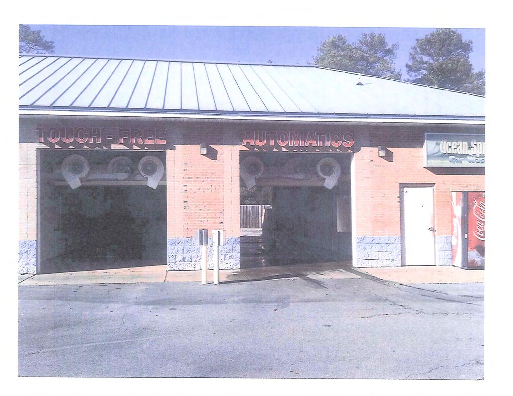
164

165
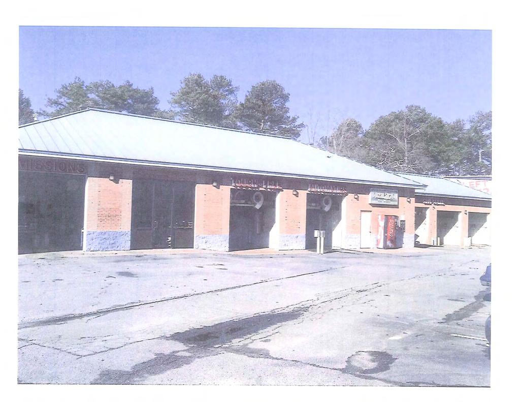
166
167 PIN ETRE E PASS LN RHETT BUTLER DR BELLE CT TARLETON DR PITTY PAT CT HABE RSHA M JEMMS DR RDG 6-63 GEN EV A DR LAKE LUCERNE DR SAINT BERNARD DR LAKE LUCERNE WAY LAKE LUCERNE RD RIVERSIDE DR 6-64 JESSICA DARON CT PAXTON LN VALLEY DALE DR ALPINE DR SAINT MORITZ DR RO SS CIR VALLEY DALE CT 6-62 ROCK HAVEN DR MATTERHORN DR RO BIE RD 6-55 ROSS RD ROS S CI R VE COMA L N PARKER CT SHELBY LN PUCKETTS DR GRESHAM CIR WHALEY RD 6-56 HUDSON DR LUNCEFORD LN THORNDALE WYNNMEA DE LN DR BRANDON DR RIVE RCLIFF D R PARK WAY STONE MOUNTAIN HWY CAMP CIR MANKIN DR VIVID DR COLONIAL OAK WAY DAVIS RD DAVIS OAKS CT CANNON HILL RD RODAO DR STONE DR SUP Printed: March 7, Feet BEVERLY DR CASTLEWOOD DR 6-45 SHILOH RIDGE TRL
 rl\"l --~~ 1\"1 ;:o SHOPS AT LUCERNE LANDINGS K'Rl<WOOO IUVESTI.lEUT CO'~PAJIY fa, llc llb~ LUCERNE LAND.. 'io; US. S'. ALJ.. DUSIIoESS AD'~ r N I STRATIOil; GEORGL\"' I.!OU:ITA!IIS REGIONAL ECOioO'!")
168 Cl) c: -o (.) 0 IJ 'N 0 0 N I CXJ ::0 m ("') m m -< 0 Z< --lt/10 z { TT y ( ~ ~!,// 0 J'~ g / o o< 0 ii e~ ~ ~~ ~~ ~~ / (./) l> z :~> (./)-1 I~ CJJ-< c -(./) rl"l --~~ 1"1 ;:o SHOPS AT LUCERNE LANDINGS K'Rl<WOOO IUVESTI.lEUT CO'~PAJIY fa, llc llb~ LUCERNE LAND.. 'io; US. S'. ALJ.. DUSIIoESS AD'~ r N I STRATIOil; GEORGL"' I.!OU:ITA!IIS REGIONAL ECOioO'!!C OEVELOI'I.'E.'IT CORPO.'~ATI0!-1; STEWART ffile GU;\RANTY COW'AtiY, F1RST IIATIO/W.!lAW< OF G\'o a ;ETT WID lohj, 6TH O.'STR!CT G\'iif;!''ETf OOWHY, GEORG~'\
169 MATTERHORN DR STONE MOUNTAIN HWY SUP Printed: March 7, Feet
170 C2 SAINT BERNARD DR M ALPINE DR SAINT MORITZ DR 6-63 R100 LAKE LUCERNE RD C RM R100 OI 6-62 OI MATTERHORN DR LAKE LUCERNE DR C2 OI ROBIE RD R100 C2 STONE DR C1 STONE MOUNTAIN HWY 6-56 OI GRESHAM CIR WHALEY RD FERNCROFT CT R75 WYNNMEADE LN THORNDALE DR LUNCEFORD LN DUDLEY CT TARENCE LN BRANDON DR SUP Printed: March 7, Feet HUDSON DR R100 RIVERCLIFF DR
171 GWINNETT COUNTY DEPARTMENT OF PLANNING AND DEVELOPMENT SPECIAL USE PERMIT ANALYSIS CASE NUMBER :SUP ZONING :M-1 LOCATION :1700 BLOCK OF JEURGENS COURT :5300 BLOCK OF GOSHEN SPRINGS ROAD MAP NUMBER :R ACREAGE :23.55 ACRES SQUARE FEET :128,800 SQUARE FEET PROPOSED DEVELOPMENT :MAINTENANCE SHOP (RENEWAL) COMMISSION DISTRICT :(2) HOWARD FUTURE DEVELOPMENT MAP: REGIONAL MIXED-USE APPLICANT: ENTERPRISE LEASING COMPANY OF GEORGIA, LLC C/O ANDERSEN, TATE & CARR, P.C SATELLITE BOULEVARD, SUITE 4000 DULUTH, GA CONTACT: R. MATTHEW REEVES, ESQ. PHONE: OWNER: TENANTS IN COMMON ATTN: IAN SMITH, AGENT, KNIGHTSWOOD, INC PEACHTREE ROAD, SUITE 150 ATLANTA, GA DEPARTMENT RECOMMENDATION: APPROVAL WITH CONDITIONS PROJECT DATA: The applicant requests the renewal of a Special Use Permit on a acre parcel zoned M-1 (Light Industry District) to allow Enterprise Leasing Company of Georgia, LLC to operate its regional vehicle maintenance center from the current location. The site is located along Jeurgens Court, just north of its intersection with Oakbrook Parkway. The property also has frontage along the south side of Goshen Springs Road. The Special Use Permit allowing a maintenance shop (fleet vehicles) facility with the outdoor storage of fleet vehicles was approved in 2016, pursuant to SUP , with a time limitation of twelve months. Since the initial approval, the applicant has not received any complaints regarding the utilization of the property, and has obtained the necessary permits in order to satisfy the conditions of zoning.
172 SUP (TH) ZONING HISTORY: In 1970, the subject property was zoned M-1 (Light Industry District). In 1989, the property was zoned to C-3, with a Special Use Permit allowing an exhibition hall, pursuant to RZ and SUP The property was rezoned to M-1 in 2016, with Special Use Permit allowing a maintenance shop (fleet rental) facility, pursuant to RZC and SUP GROUNDWATER RECHARGE AREA: The subject property is not located within an identified Significant Groundwater Recharge Area. WETLANDS INVENTORY: The subject property does not contain areas, streams, and/or bodies of water depicted as wetlands on the U.S. Department of Interior, Fish, and Wildlife Service National Wetlands Inventory map on file with the Gwinnett Department of Planning and Development. OPEN SPACE AND GREENWAY MASTER PLAN: No comment. DEVELOPMENT REVIEW SECTION COMMENTS: No comment. STORMWATER REVIEW SECTION COMMENTS: No comment. GWINNETT COUNTY DEPARTMENT OF TRANSPORTATION COMMENTS: Jeurgens Court is a Local Street and 30 feet of right-of-way is required from the centerline. GWINNETT COUNTY ENVIRONMENTAL HEALTH COMMENTS: No comment. GWINNETT COUNTY DEPARTMENT OF WATER RESOURCES COMMENTS: The available utility records show that the subject development is currently in the vicinity of a 12-inch water main located on the east right-of-way of Jeurgens Court and a 12-inch water main located on the southeast right-of-way of Goshen Springs Road. The available utility records show that the subject development is currently in the vicinity of eight, 27, and 30-inch sanitary sewer mains located on parcel R
173 SUP (TH) BUILDING CONSTRUCTION SECTION COMMENTS: Building Plan Review has no objections under the following conditions: 1. The applicant shall submit architectural, structural, mechanical, electrical and plumbing drawings for any proposed interior or exterior modifications for review and approval by Building Plan Review. 2. Upon completion of plan review approvals, the applicant shall obtain a building permit for any proposed modification/renovation work and achieve satisfactory field inspections for issuance of a Certificate of Occupancy. For assistance, you may contact this office at Monday through Friday from the hours of 8:00 a.m. to 5:00 p.m. GWINNETT COUNTY FIRE SERVICES COMMENTS: No comment. DEPARTMENT ANALYSIS: The subject property is a acre parcel, formerly known as the North Atlanta Trade Center. The site is located along Jeurgens Court, just north of its intersection with Oakbrook Parkway. The property also has frontage along the south side of Goshen Springs Road. The property consists of a 132,381 square foot commercial building, associated parking and driveways. The 2030 Unified Plan Future Development Map indicates that the site is located in a Regional Mixed-Use Character Area. Although the maintenance shop would not necessarily be consistent with the policies of the 2030 Unified Plan, the applicant has operated from the site without incident, obtained the required permits and occupied a space that was in the initial phases of decline. The requested renewal of the Special Use Permit is further supported by the applicant s continued cooperation with county policies regarding the redevelopment of the site that enhances the efforts of the county to revitalize the area. The surrounding area along this segment of the Oakbrook Parkway/I-85 corridor is characterized as an intensely developed area consisting predominately of industrial sites that include outdoor storage being served by heavy truck traffic. Industrial zoning and uses are located to the north, west and south of the site, with a residential component zoned MH (Manufactured Housing) being located immediately to the east. The conditions of zoning were designed to ensure that a fleet maintenance facility would be compatible with other light industrial activities taking place in the immediate area. The applicant s willingness to comply with the conditions of zoning further supports this request. In conclusion, during its initial year of operation, the applicant has complied with conditions of zoning and no complaints have been filed regarding the use. Therefore, the Department of
174 SUP (TH) Planning and Development recommends APPROVAL WITH CONDITIONS of this request.
175 SUP (TH) PLANNING AND DEVELOPMENT DEPARTMENT RECOMMENDED CONDITIONS Approval of the renewal of a Special Use Permit (renewal) for a fleet maintenance facility with outdoor storage, subject to the following enumerated conditions: 1. To restrict the use of the property as follows: A. Light industrial, office, office/warehouse and accessory uses and structures, which may include a fleet parking and fleet maintenance facility with outdoor storage as a special use for the applicant only. B. Any new buildings shall be finished with architectural treatments of glass, brick and/or stacked stone on the front façade, or such other materials as approved by the Director of Planning and Development. C. Except for the parking of fleet vehicles, outdoor storage shall be screened from Jeurgens Court and meet the standards of the M-1 zoning district. 2. To satisfy the following site development considerations: A. Provide a ten-foot wide landscaped strip adjacent to all rights-of-way. B. Dumpsters shall be screened by a 100% opaque fence or wall with an opaque metal gate enclosure, or shall be kept within the screened outdoor storage area. C. Use of outdoor loudspeakers shall be prohibited between the hours of 10:00 p.m. and 6:00 a.m. D. New or replacement billboards and oversized signs shall be prohibited. E. Lighting shall be contained in cut-off type luminaries and shall be directed in toward the property so as not to shine directly into adjacent properties or rights-of-way. F. Owner shall repair or repaint any graffiti or vandalism that occurs on the property within 72 hours. G. No tents, canopies, temporary banners, streamers or roping decorated with flags, tinsel, or other similar material shall be displayed, hung, or strung on the site. No decorative balloons or hot-air balloons shall be displayed on the site. Yard and/or bandit signs, and sign-walkers or sign-twirlers shall be prohibited. H. Landscaping shall be enhanced and installed so that it increases the density of property s existing landscaping along Jeurgens Court. Landscaping shall be planted with a mix of deciduous and evergreen trees and shrubs in a manner intended to maintain the visual screen and consistent aesthetics along Jeurgens Court. The final landscaping plan shall
176 SUP (TH) be subject to review and approval by the Director of Planning and Development to ensure that the plantings are consistent with the quality and appearance of the existing landscaping of the properties along Jeurgens Court. I. Subject to Goshen Springs Road being open and accessible to all deliveries and pick-ups of fleet vehicles, whether driven or delivered by trucks: truck shipments orientation from the property and contractors access shall be directed to, and made via, Goshen Springs Road. Jeurgens Court shall be used for employees, office use and deliveries only. Controlled access gates shall be installed at the property entrance on Jeurgens Court. J. The façade of the building facing Jeurgens Court shall be cleaned. K. Upon extension of the Special Use Permit, after the initial 12 month period, The portion of the building facing Jeurgens Court, below the windows, shall be enhanced with architectural treatment of brick and stone appearance subject to review and approval by the Director of Planning and Development, and light poles on the property shall be repainted to a neutral color. L. Any fuel tanks installed on the property shall have a maximum capacity of 5,000 gallons and shall be located no less than 500 feet from Jeurgens Court right-of-way and shall be screened from view of Jeurgens Court. M. This Special Use Permit shall have the initial duration of months from the date of approval. At the end of that period if the applicant has not been issued any notices of violation of conditions as stated herein that have not been timely cured, the applicant may reapply for an extension of the SUP. N. The applicant shall notify the Director of Planning and Development, in writing, when the applicant ceases to be the tenant of the property.
177 SUP (TH) PLANNING AND DEVELOPMENT DEPARTMENT RECOMMENDATIONS STANDARDS GOVERNING EXERCISE OF ZONING SUITABILITY OF USE The requested renewal of the Special Use Permit to allow the continued operation of a maintenance shop (fleet vehicle) facility could be appropriate at this location in view of the light industrial uses in the immediate area. ADVERSE IMPACTS With the continued compliance with the previously established conditions, no significant adverse impacts are expected from the renewal of the Special Use Permit for maintenance shop (fleet vehicle) facility. REASONABLE ECONOMIC USE AS ZONED The subject property has a reasonable economic use as currently zoned. IMPACT ON PUBLIC FACILITIES No change in impacts on public utilities would be anticipated from the continued use of the facility as it presently operates. CONFORMITY WITH POLICIES The request to renew the Special Use Permit would be consistent with the previous Board approval, which required a new application be submitted for review and approval if the applicant did not violate the conditions during this time period. CONDITIONS AFFECTING ZONING The precedent established by the Board for this property and the applicant s compliance with the conditions of zoning during their initial year of operation provides supporting grounds for granting of the request.
178 Gwinnett County Planning Division Special Use Permit Application Last Updated 2/2014 SPECIAL USE PERMIT APPLICANT'S RESPONSE STANDARDS GOVERNING THE EXERCISE OF THE ZONING POWER PURSUANT TO REQUIREMENT OF THE UNIFIED DEVELOPMENT ORDINANCE, THE BOARD OF COMMISSIONERS FINDS THAT THE FOLLOWING STANDARDS ARE RELEVANT IN BALANCING THE INTEREST IN PROMOTING THE PUBLIC HEALTH, SAFETY, MORALITY OR GENERAL WELFARE AGAINST THE RIGHT TO THE UNRESTRICTED USE OF PROPERTY AND SHALL GOVERN THE EXERC ISE OF THE ZONING POWER. PLEASE RESPOND TO THE FOLLOWING STANDARDS IN THE SPACE PROVIDED OR USE AN ATTACHMENT AS NECESSARY: (A) WHETHER A PROPOSED SPECIAL USE PERMIT WILL PERMIT A USE THAT IS SU ITABLE IN VIEW OF THE USE AND DEVELOPMENT OF ADJACENT AND NEARBY PROPERTY: Attached (B) WHETHER A PROPOSED SPECIAL USE PERMIT WILL ADVERSELY AFFECT THE EXISTING USE OR USABILITY OF ADJACENT OR NEARBY PROPERTY: Attached (C) WHETHER THE PROPERTY TO BE AFFECTED BY A PROPOSED SPECIAL USE PERMIT HAS REASONABLE ECONOMIC USE AS CURRENTLY ZONED: Attached (D) WHETHER THE PROPOSED SPECIAL USE PERMIT WILL RESULT IN A USE WHICH WILL OR COULD CAUSE AN EXCESSIVE OR BURDENSOME USE OF EXISTING STREETS, TRANSPORTATION FACILITIES, UTILITIES, OR SCHOOLS: Attached (E) WHETHER THE PROPOSED SPECIAL USE PERMIT IS IN CONFORMITY WITH THE POLICY AND INTENT OF THE LAND USE PLAN: Attached (F) WHETHER THERE ARE OTHER EXISTING OR CHANGING CONDITIONS AFFECTING THE USE AND DEVELOPMENT OF THE PROPERTY WHICH GIVE SUPPORTING GROUNDS FOR EITHER APPROVAL OR DISAPPROVAL OF THE PROPOSED SPECIAL USE PERMIT: Attached 3 SUP ' RECEIVED BY MAR Planning & Oeve\opment

179 EXHIBIT "8" 1700 JEURGENS COURT, NORCROSS, GEORGIA APPLICANT'S AND OWNERS' RESPONSES IN SUPPORT OF SPECIAL USE PERMIT EXTENSION A) WHETHER THE REQUESTED REZONING, SPECIAL USE PERMIT, AND/OR CHANGE IN CONDITIONS WILL PERMIT A USE THAT IS SUITABLE IN VIEW OF THE USE AND DEVELOPMENT OF ADJACENT AND NEARBY PROPERTY: Yes. The subject property is a fully accessible site with an existing, moreintense use, and the requested uses are consistent with the similar industrial and fleet maintenance uses, including, but not limited to the Advanced Disposal and Bus Max fleet, transit and business centers located in that mixed-use corridor and area. The subject property was also previously zoned M-1 and is surrounded by similarly-zoned property and uses, and accordingly, the requested uses, zoning and conditions are suitable in view of the use and development of the adjacent and nearby property. As reflected in 2030 Comprehensive Plan for Gwinnett County, the subject property is intended for Regional Mixed-Use. The intent of that 2030 land use goals are met by the proposed uses and conditions. B) WHETHER THE REQUESTED REZONING, SPECIAL USE PERMIT, AND/OR CHANGE IN CONDITIONS WILL ADVERSELY AFFECT THE EXISTING USE OR USEABILITY OF ADJACENT OR NEARBY PROPERTY: No. The subject property was also previously zoned M-1 and is surrounded by similarly-zoned property, and accordingly, the SUP extension request is compatible with the existing uses and useability of the adjacent and nearby property. C) WHETHER THE PROPERTY TO BE AFFECTED BY THE REQUESTED REZONING, SPECIAL USE PERMIT, AND/OR CHANGE IN CONDITIONS HAS A REASONABLE ECONOMIC USE AS CURRENTLY ZONED AND CONDITIONED: The property only has a reasonable economic use if the current SUP is extended. D) WHETHER THE REQUESTED REZONING, SPECIAL USE PERMIT, AND/OR CHANGE IN CONDITIONS WILL RESULT IN A USE WHICH WILL OR COULD CAUSE AN EXCESSIVE OR BURDENSOME USE OF EX IJ ST TRANSPORTATION FACILITIES, UTILITIES, OR SCHOOLS: 1::: IV1 SUP ' MAR
180 No. This property is located in an area with public water and sewer availability, and direct access to two major thoroughfares, highways and interstate. The development is consistent with the Comprehensive Plan, with no impact on schools. The requested special use permit extension is expected to be less intense then the existing trade center use, and will not cause excessive use of existing streets, transportation facilities or utilities. E) WHETHER THE REQUESTED REZONING, SPECIAL USE PERMIT, AND/OR CHANGE IN CONDITIONS IS IN CONFORMITY WITH THE POLICY AND INTENT OF THE LAND USE PLAN: Yes Comprehensive Plan identifies the subject property as an appropriate location for Regional Mixed-Uses and will positively impact the existing industrial and commercial area, and consistent with the prior zoning and uses permitted on the subject property. F) WHETHER THERE ARE OTHER EXISTING OR CHANGING CONDITIONS AFFECTING THE USE AND DEVELOPMENT OF THE PROPERTY WHICH GIVE SUPPORTING GROUNDS FOR EITHER THE APPROVAL OR DISAPPROVAL OF THE REQUESTED REZONING, SPECIAL USE PERMIT, AND/OR CHANGE IN CONDITIONS. Yes. The requested Special Use Permit extension is absolutely necessary to enable the Applicant and Owner to operate this quality business, fleet center and maintenance use by Enterprise. SUP ' RECEIVED BY MAR Planning & Development


181


182

183
184 CASE NUMBER SUP20 16~000 I 0 GCID GWINNETT COUNTY BOARD OF COMMISSIONERS LAWRENCEVILLE, GEORGIA RESOLUTION ENTITLED: Grant of Special Use Perm it ADOPTION DATE: APRIL At the regular meeting of the Gwinnett County Board of Commissioners held in the Gwinnett Justice and Administration Center, Auditorium, 75 Langley Drive, Lawrenceville, Georgia. Name Present Vote Charlotte J. Nash, Chairman Yes Aye Jace Brooks, District I Yes Aye Lynette Howard, District 2 Yes Aye Tommy Hunter, District 3 Yes Aye John Heard, District 4 Yes Aye On motion of Commissioner COMM. HOWARD, which carried a 5~0 vote, the following Resolution to Amend the Official Zoning Map of Gwinnett County is hereby adopted: WHEREAS, the Municipa imgwinnett County Planning Commission has held a du ly advertised public hearing and has filed a formal recommendation w ith the Gwinnett County Board of Commissioners upon an Application for a Special Use Permit by ENTERPRISE LEASING COMPANY OF GEORGIA. LLC for the proposed use of an MAINTENANCE SHOP (RENTAL FLEET) on a tract of land described by the attached legal description, which is incorporated herein and made a part hereof by reference; and WHEREAS, notice to the public regarding said Amendment to the Official Zoning Map has been duly published in THE GWINNETT DAILY POST, the Official News Organ of Gwinnett County; and RECEIVED BY MAR Planning & Development
185 CASE NUMBER SUP2016~00010 GCID WHEREAS, a public hearing was held by the Gwinnett County Board of Commissioners on MARCH and objections were filed. NOW, THEREFORE, BE IT RESOLVED by the Gwinnett County Board of Commissioners, that the aforesaid application for a Special Use Permit is hereby APPROVED with the following enumerated conditions: I. To restrict the use of the property as follows: A. Light industrial, office, office/warehouse and accessory uses and structures, which may include fleet vehicle maintenance as a special use. B. Any new buildings shall be finished with architectural treatments of glass, brick and/or stacked stone on the front fac;ade, or such other materials as approved by the Director of Planning and Development. C. Except for the parking of fleet vehicles, outdoor storage shall be screened from Jeurgens Court and meet the standards of the M-1 zoning district. 2. To satisfy the following site development considerations: A. Provide a ten~foot wide landscaped strip adjacent to all rights-of-way. B. Dumpsters shall be screened by a I 00% opaque fence or wall with an opaque metal gate enclosure, or shall be kept within the screened outdoor storage area. C. Use of outdoor loudspeakers shall be prohibited between the hours of I 0:00 p.m. and 6:00a.m. D. New or replacement billboards and oversized signs shall be prohibited. E. Lighting shall be contained in cut~off type luminaries and shall be directed in toward the property so as not to shine directly into adjacent properties or rights-of~way. F. Owner shall repair or repaint any graffiti or vandalism that occurs on the property within 72 hours. G. No tents, canopies, temporary banners. streamers or roping decorated with flags, tinse l, or other similar material shall be displayed, hung, or strung on the site. No decorative balloons or hot-air balloons shall be displayed on the site. Yard and/or bandit signs, and sign-walkers or sign-twirlers shall be prohibited. RECEIVED BY H. Landscaping shall be enhanced and installed so that it increases the density of property's existing landscaping along Jeurgens Court. Landscaping shall be planted~l\h ~ tfli&q:1v Planning & Development
186 CASE NUMBER SUP I 0 GCID l 53 deciduous and evergreen trees and shrubs in a manner intended to maintain the visual screen and consistent aesthetics along Jeurgens Court. The final landscaping plan shall be subject to review and approval by the Director of Planning and Development to insure that the plantings are consistent with the quality and appearance of the existing landscaping of the properties along Jeurgens Court. I. Subject to Goshen Springs Road being open and accessible to all deliveries and pick~ups of fleet vehicles, whether driven or delivered by trucks: truck shipments orientation from the property and contractors access shall be directed to, and made via, Goshen Springs Road. Jeurgens Court shall be used for employees, office use and deliveries only. Controlled access gates shall be installed at the property entrance on Jeur gens Court. J. The fa~ade of the building facing Jeurgens Court shall be cleaned. K. Upon extension of the Special Use Permit, after the initial 12 month period, the portion of the building facing Jeurgens Court, below the windows, shall be enhanced with architectural treatment of brick and stone appearance subject to review and approval by the Director of Planning and Development, and light poles on the property shall be repainted to a neutral color. L. Any fuel tanks installed on the property shall have a maximum capacity of 5,000 gallons and shall be located no less than 500 feet from Jeurgens Court right - of~way and shall be screened from view of Jew gens Court. M. This Special Use Permit shall have the initial duration of 12 months from the date of approval. At the end of that period if the applicant has not been issued any notices of violation of conditions as stated herein that have not been timely cured, the applicant may reapply for an extension of the SUP. N. The applicant shall notify the Director of Planning and Development, in writing, when the applicant ceases to be the tenant of the property. GWINNETT COUNTY BOARD OF COMMISSIONERS By: ATTEST:, -"3 Planning & Development
187 PIRKLE RD CHARMAINE BND BALDWIN CT NORCROSS SUMMERTOWN DR LN WESTBERR Y SHAWNEE TRL MITCHELL RD RESEDA CT HUDDERSFIELD WAY GOODWICK WAY STATION CIR RAILS WAY NEWBURY RD WEXFORD DR PINNACLE CT PINNACLE WAY PINNACLE POIN TE DR BROOK HOLLOW PKWY BEAVER RUIN RD TRAIL PKWY WILLOW BOLTON CIR KIMBERLY LN HAMMOND DR HOOT OWL TRL I85N LANGSTON RD GOSHEN SPRINGS RD JEURGENS CT VINEY ARD POND DR HILLCREST RD LANIER TER H ASE C O MMON CT WADE DR H O LLOW RIDGE LN LIA HILLS DR FERENTZ TRCE DAVID ST GOSHEN SPRINGS RD FIG ST ADAM ST BOAZ ST EZRA ST MAIN CIR W MAIN ST COVE CREEK CIR WIL L OW OA K TRL INDIAN BROOK WAY HILLCREST RD I85S OAKBROOK PKWY INDIAN TRAIL GEORGIA BELLE CT MONTE SINAI DR CENTER WAY OAKBROOK DR WOODBIN DR COUNTRY TRCE LILBURN RD TREE TRAIL P KWY KINGS RIDGE DR ROBIN HILL DR SILVER REDDINGTON LN HYDABURG LN SUGARWOOD LN HOY T AYLOR DR TECH DR OAKBROO K LAKE D R SUP Printed: March 7, Feet H AMPTON RIDGE RD HARBINS RD EST ATE S CT WHITE WING CT ROMAN POINT DR CAESARS WAY LAK E DR COUNTRY DOWNS DR DOWNS WAY DOWNS LN SINGLETON RD S A NTA A NNA DR 6-173
o<otlltc'j.).'t r_._u'llr.n..- Ju..X.\"'~<..._.._,_. ntwut.gitli!ilojj 1 1 Uf l'.f.l~t1u:nci!o'ii'll 1i'IUIM.I.U...,_lUI.O.. ~f hl: ltr.")
188 llr. ~~CUI..."RTq,. IN/'o' t;tt C:I'JUflll. T. liw'jiuii-a lt&,\iiis'j.-i.~ot' Uli!J)U!l m.ii'uil"t, LIJOI'tr.<o,,\I:.O ocn--ij T11LC't..~ Of JJJ ::0C'OI.:Tj..-IUUirT~-*AlJ. Tl0JoiC'I. LI.A\1700'TliO.:Ce.'lUIJ..._,.,~~ r.aj.j,..- ' I '..U:D l t.."''au)o<otlltc'j.).'t r_._u'llr.n..- Ju..X."'~<..._.._,_. ntwut.gitli!ilojj 1 1 Uf l'.f.l~t1u:nci!o'ii'll 1i'IUIM.I.U...,_lUI.O.. ~f hl: ltr. \ ltl lltfi-u.\\1jl'lll.~fi-i..,ijtouiud,.._,i,..d\c.i:l:sj.i\tl,_ I "JT,.3o~IIUIS'DSLo.1T, I,'h: fn :l 1111:1\Ct.U ~\"lp-co I IU..l"l ~'li' ILit i Z"'~ Uo- I<(.A\ Ll IU..,._ l')u.u.. ~ji, ' Jli...Z lr.-oin\-jm.i.f,.._t..i\t IL\.'OIIo;,..Al..._ADO"ICIIIT"-"" rn;"'-<"o~i, \I'OII~ItlP!S, llmi "'---..IWII.DCl'-QII AJO OJT'Ili.!C'TI-..uliiO'AIWU:OO.UDI'II.Uf'UI.l"\, llt ~/U"'-..._1 llt:sifn,._ticwo.!io~of1k'>f'l!rrn' "-'Dl HI ' IOCA~ or.oj.i,.,... r.;r.oo~oi'a.'t l :snto CIU. ~-.,-,'IIIIli.. I'WI J Vl'.WI~..,- 0\'l'A..,.-.,Tioot,JITUfo'l'l'~OIIOO.,n'- \10 ~r..... u.uvhr ro.wn.... o-ntulloo'it~'uil...,...,.,.~..,,u...w~t'r '"' Hit."K -'lfi,-oc:atui WI'NI "'Tllr. ltl;ll-..,..d.uiy \n<u!of~~- l'tnf't..l T\U..V.CU'T'.ul t'lajit~.c't ~--r-----!:" r. L.U:wt:JIIl.AlO&Joll.VfF\tt.'IWCKAII.UECIU..Il.,U..'DJIAAT.TTt' C''-1flltfJ.AI.. n(tll'ml: HI QWTl'o'!IICTlc;"\ 'T'f.III'OUlll'Al.MJ.OI\l!llll'lot ' ll U::i'T,._Tf.OI'tn.tiiOI"-1'1-'1 1 ) ~1"1 JI.I...,...U-C'OaDU)ATDUOti(Vt;:... I.P...uti"l. IU~'UIU.:Ufll1[CU.a"-Uf11n:":r-FJ.IOl cnrr r r~-wn>o:tt~. OI-.a-:Ot"-! JI&W\;RP_--WJ"" rloo-ionlllf,... S~C\'I NP_..,., T\IOWII'I)'Io'll'n \.U.':'Il'I,. \1'\~Jfl(.', \1, st:uowiiionof'tlie: ITA'Tf.Of(lf.O.OC"-I'lATJ'Zl"l,\ ".1""-1fCUI'Of'.DATOQ:I\..._II'l r iiul:......a...jdlect>llll J. P.JUIUQI...,-,ltot--IM.U..UII-I(.'. llll.\l:)'(otlt~k'\tfl'.).t.ij<...-'iifjxw,\,11 C"')Unj! noo.. D'ITWW.U.ctl loo. I J. D.("'IUJI;JJI\lUU.D~)OD.PAOI:"-""""""'tra>llfllfo. T1RSI'ItUf'U.T'I 1$.11\lU'TNA a...u-u.rr:i'<i"jflo:lllotado I,'oC, lu,\ I la'o"uaiiuo!nc'ijm r'l..~r. IMJWAl..UST! I I- lfc'ixdt.d"'rixt:oijool.jfli, PAOl.MIQ.... AW~~ N(YIJlOYrCaol'l'fDil"'OK'"llCl!ol()f'T11f.lml/'fY<TI\'n).'Din'I-\ID Ut.lr-"VVTII.Ufln"'SHI'*"" ).ENCJit oa.i..luo!o.t~'tal;jtn:).ido'tn.r... nl~l'!to-l, l. ICTOI,'PE.I.Tti"O:U.VJ..U.p..c D'ITt.OWAl' l. l!#iiix.l..hi.ui :i i!wbij~iijooi, :U::-"'P... UD T i l~ l'oit1w.njli:u o,-,c-[ rq. () "' ~ c:. '11 )II )II 1: t f) )'il '11 Ill.., 1./1-1 ::r: ' '""-1NOSSli!WrfNAill!:CALL'UIJITtOnOwNtcu:st\Jl"'l:n A.'IIUA,I..Iiii.UI'lJONIIAS-jii_,1,T::U.VI:Yl'OIIIoi..I.IUI011-tU D.JI\'tcf.WIItlU.J;,\U.I.'\.IUOit.-I110H &IJ.uJW_..,N_.,CI:J.II:7o"l C._..,."-"'Y, PYI'If.l.IUI'It' OOCT/. ACI..-Jt.-llMliS''1'1-IlU.l IA.'IOiiJII\' r:'l'(l~~uoi'jl'utiofol... Vt--lllt~ \ 17'1,!.AlOI"("'(O(OTS: l 1 D l 'OTAI.S'TIIT10HWIU\.,I.Dl001rfAJ... UI'<II""-A'ODAHCU...U:Wt:ASL'kl:wl';l'<ll'l JTIIV.Iu.JDOAlAI.o'JO!oWIUCUnU:IMJITIS I~J) II.U C'U:~l.IIU :... ~CJf'l' l"-- ' '-""11;\loll\.l'o(JUI.AJI I..IIJ.Oit!lt' IO~U'OI'<IIM P 1 ~.J:"lii T... OW.o.\ l\l)"--'1:0l1sil"o /IlL (llljrtatiia:iiicr,.-co.lrutallllroti:cl.o:.l'iii: AMib Klll"lll111U.M.'C111AlT.TOI' I II.IIOU l!n;l.,.llflll'llnt""d litli.nlfjo 11 ~ IIAV).IOJ.Joii.OC,\11.1) fi:ol\ fll:lnlllll'lvt:l o:-.niiuol.\~an.\jiu'i""-1..~1\\"li(a,\', U\,UI~I''IUi).IMI,.IC'ti'AimJ.:sOII l!iu.fl'\ l V.t.ltA IIU,,\IIoUI:xa"'MII-...I"'' IIOG). llll. lllliivlyu. M.\la-:rtoo tocajt.v."tl.l:llli T llhtl'l-idi:aottroutnllftlulloiliikiw"' C'U:llnllll, IU.I.~ll('1\ ormrrn_.. L'lliii.A.Il.I ~\.I)IIP. A1"SI:ai1C"' : ot Nl.oi.O.:I'W'N1:o nu: Rra\"J;\~ tf l l -n l~l Dl'JUI..._,1..,,\lllt.\.. l'l11,\tl1u! L,_.OCIUIIU'II:NI111'1'1/nli'S ~~~')I,UU: r,.: fill f.~.w.'t in(' AHt,._. I,..UICAIIJIAl.lliUOJQIIHI : OOt.:s:n'Alt: nra'!'lllty o\iu..ii<cati:ua~ o>cc\ilalu \'.U I'UUII\O J, """" 1"'1-VIUV.TJO:-t,o\\',\JIAIIU, Tll!, ~'l\l:\' ()llja.1)i(itrln' 'llr,\ii. YifiC' Il LI""tttlmiOO-,...>I'nlrfn:S '.WIDUCIWa:lJ... Un.l.ll tiij,.oc. \ n.o-." mu.<.:a..;aill:ail\\11'-'q"~i')i';w:ii.. 'I~ X ayntli'wl.tl\ [.~~~~1':~~fu~1~ f;t~=~~?l ~(-..: ;::~.:~.~~~lll.l 1rti\"U"A.!...O.:I$JT'I ID'IKli'-"':<<C'\lf'aT4''1)~~~~- A rt-..::' nn SI'"'IJUOI' nli.~.u P...u.! MlW'""--l-,JIIJ..:AT1'1lO\IITliE~'JIJU'T,..fwr_.n I',\."ITh'TK~aStiW.I_...J>('" \I'II II,,',U J. \ ~ l lt-~lluu. I...: e~o.-""'ototmt, \U.I'Ii\1\l'U,. IIItL."-'IJI..\I'oO o\.'-oiiu:"'ljlo.:la.'ijl.ol' f1 -.ut'tlli: '-TI1tA'"DI)~TlUI..'T '-'""":<Lnl"\A."-1\ \ot.jiiiich,\niiitu."'u)oioiu.r\kiic"' 'I,\.ItJ ' llt~iiww. '-'>I'I. III J.~J-~0') T'llfT"l)Tlti'\'Of'\'TOIT!.-111'1/l'CI\Iolll.("("""'L...,.'ITTlU'\!Ol'U.-'\ll.'T\ID'oo:fYTliL«''TU.t..rM: U(t l \lai'ioiii.: raltj.... Al'tl«tll(llrT4...,'A\t"'TT11T1li: C1'_,..'1lli ini OI' " IIo1Uan.UI'Ili'INO Tl!l:.n.snau..."to.-u~ loi.. r ~,..,, - m.,oul.ujj5f-~ll-lt"t'l'l \:V:t1,..._t.o.n".. ts\'ltj<-'!sfco'-idi...,.ni'oii-'i.iist..o..l<l..tyl oln"xttoar<tl...,., tlill<(li:a.v\..._. II.UIIl1.'1l_.l!.r.«.l1011'!1-I'M Dl'.u.LI"Jtolll~lr.>.l"n:JI I!Q'(.'P"'.. ~Jn Rll: o\ I'IIIS"'"""--'POf'.,.-:1' rr.j:tti)"p'or.(t,-...:nll: ljgirt«_.a \' 1 1:-.l:Ofn:lAiloo-'J(.'{li'I!T~f'()IINTDCIJOOTlfr.ro/\loiT llii~'oit't.ii...'"""'..sillllllljj>o, o,,\1 INI,,. Jn.lti-'.1GO..lf -.T:"'IOI1ll ""'DI'-~_D _,wr.on!tt.j 4.'1.CI... IIIi""'l:sTT'Ol,\DI5TA.>.;(.'I;OlfJ116\n.r;tm'l p("kn"''llir."lt. IIoli*TII_l-tllf-OIIr7.1o<l.l ~"1/llJI 1J ~.l'u<'ill ""'UCTfUII AoaiAt '.,.7 1U.l' Tl)AMJil'<-T. IAIIJPO!)ITIIl.JMlu.tTIIt w.a 1 niuu. I UJHI' ~AlU!IIllue'I.A IU;.-.;Ii"'IJNNJ!!.u...Dc-ll ltioitt-oi' """A'').nii'>ICI:ALOI'Cl a.udloi l 'T IU:IU.X IUOUI3 "''-'Y Ul'if "'*H I... t)ta.,afj_i.l UJ:'o\JfD I ) ~ I".Cr "'""'-"-,-"*o«4fji!ct'-'<'tw 1J.-, I'I".rTmA,_"ll!<oT~OlW'rii'<IUI)otl.o.LI _loo(l!iaid :OO._,'\'Ilr.A.U mrr...,.....,- u:-o:r..ujl!o('i ntr...uo('"" "CI-.vr.Tunu: ootn....,"--..m...,..," rl:.t:tto,\put.'ti1amaac' II.\\INOIIIt WI1 :S UII"IO...:Ift.CTM"'IIUNUlii.'UTT_,..D(DDl' A l'l~-ij I II.UIM:I:'Io'llll 'll l> ll )lo(ltllll.jo U... u :-.t n~)ll~,l.-.osiji; 1 ~ \Kf \,'1/\l ll/\\'l'o(j.\i...t:..'fu"l l\ C. U \ti..,_'1..., UJ<I!U.('I')Oo.~ t.a.'cf 1'0. --"lll!l"..._'o(.l Of \fl _,., l't.t:trl--" "-"""""'UU'."'<l.U')Oo,.lSIIJ'IO o~.~ Mt:H \\l )I(II'Tlii'J:IY uun~.-,.yu:-o:c.u_o...-onu.uc A('l 'l~ttitltl. tan.,.. llt\"l'l..-.c'l UI"I <'I!>J.II.Y.T'10 \,..11!-oT!S.\JI) \l(' lf,\\ijoic I ~il.a.()ii!'ii.. Ir..I"'' ":J!To\,'1101'1'11'00.SLlrTT.SI)U) II\' ACIIOilOIII'-"'.r.KINOIIl11UOU..ItfJ:S'J "'lni'tt'.ji)ifo.-oe.."dsra\"l'a.''tiha\t:'oo A II.S!Jrt l flii io'il7 1TJ,T\TU"l'l.m..T. T111:!"lT.\I.O...OS-\lDSI'II..'Tllfl.l.l ' lticlitt<fw-yt'ay\..1''1: 1-'0itTII,. Df01t. UH.I-ll.'~~I'TU ) l.coi'u.r.mti'\mi--"dtstn-t-'1i0f' S1. 1on:r.Ttf) AI"'roTI.OCIITt.DL"i T111. l 'L'O.Ili.L'III:OI-... \\'!:It 11.\JUOil'ltiU. T11 t:<oe t U~ I\' r.<cj),\10slll'tlll lu.t ltlukl-li!- W,U' Ul'(CA.IoiO ltt '.....-r.<c.iij~tsot1i F.n.._'Tl.I.U I<II. vt!ua\1li.iu,nclu'~lht: KJU.i>'"1~C..., -,,..._...,.-uoun~. Jl'il"lti) ) UfCIIJJ~ """.t.l 1l'o'l.'TD.Uifl.,ll'o!l "L'-"1. J.,...,I TJ.,, )()1."1141.' DQJI.US,. \l l~i'td,._sec\...-o!o f...ut. 1-w ~: fu.'t JM."ml tl) Dtrnti'J..,-111 Uf'oi'TD l,l"l'o' 'M ~ r~t. t uj f(fl'.. lljt1tu!lo-oiwffj1'1 ""1"1'Ttl "'lt-rf'n"" t.o.'t,.,..,,,-.,. lloi.._'tli.,olclltus ~ ~U,1"Jt$)'0S(.('(ltoo'lJI) L\JT. "1-"ftl:t Vlt'T11111JtGII.rUto\11,_\:Tl'SliSa:vt'fl!iol:.\S1. 1J!I:n:r.T. ~"114UUU.._il::liH"'l''1..1Tl-.U1it.CIC'ItODIIL-A''T 1'11,11 111'!'. UU.IIU.U -w WIP.-\ITU J0 n..t,,'ui'oidii "" Di -'tjls"' '-''' :~OI'.._.. n ; TT'OAI"'O!<o'T. THIXLJIA'Tll'fot.GIU:.DC I WL""'\J'TUUst()OI!o(DC ~ DT I'OI: o\!llfluontof'tl. '-"n:rt TOAI'Of!I,TC~nl l!: lt\oiit.ot '-~"\ I.D 0f JD..'aiUGC'OlaT! nroicf.iijc1t<ll~uitt11it-oj..w"' 'J l"l :..uusu1lfi.ak"of'a.o.:ii't.mtttiiv'1. 'II'IUT.u«:r.flf' n ::r... I'JJ.T10AI"'C<T~ID.o.I.CILoo\'NlAI.Alii!.'IICI"l1~ffLTI\l'oUIJOl'-o(III,'Tfl1:Mlf'.Dhl' 'IOIU&n~ ~'rnciii:u.ujj-1~1--wooltu tst(vioou.~' Ul'"-"'D H -'\Il'<l"UJooCm-ICof ici Mn:l:nlt.-IIUIOOIT "'"" ' nn. ~,-,lt uu.ni'f"'l:oot ; llnlllt... IW.."-l~"-l.L\" Aiti:.O._,illti:Dl.V.Uiil.' l\' \,h_. l:-. ll ltctai'[of<.ii:ijii<lia I I\1UI\'.._,,It! II"\ IUJ~ l'ti(;l._. IJ!ot, U C' t i.\,i.m{,..,ii' VrSh-11.;-o.'la \..DV.: v.o:n;li\11..1,,,,.-'"' t)il...o ce> rr:i coo-! "r- :"',?;~...,oo ~ ai_~t t!r, -.,~...'of" - -,~;.~~~- ~ "'--'' U~I.J:-t..I."DI.A~"\' f.nll! Uilo:JI.. O<hl"\l\U',U."'I. I I!T~IIO<'.o.rft.\Lec.: 111"\lt llll,h'.l.l, ll)o: Ttl!lt*l"""'' Tllr.,.cWJil, ' I):LUoU.\'fll.nltenHFII-O't ntat ntl'\1'\,ii,t(lt' IIJit\'ll\', l'ianllt..c'i'wj\tct\."n...u.'lllt"n:tx... ~ Ml l llt:rt.duni\'!'10!'-0i'iaio... tlt'iji'rya.''uot"llu:. Sl1.C.UJC'ATIO\'oi.L'Ttll\llDI"'L...,..,,\,UlltllJ:'I U,\Illl.llnll_lltut-;\ll"lTIIh, UnJ.:l 'WOI!I$So~Lt.I,;,\Tili'f'o'II,\... U UIII.i f.n3iohi 1Wr1tU\')JioO'.hb0Wlii\ID,.tJPCJtT"o' Uf'I\I J. fr.'--<'ul1ll'_.f.<'is. tli"...u. li<'oilixn<\-.;i'm'>ii 'lliiiijiu.til.wj,..-n..ur...tj. 51-at,[nao.ws.I:'Tlfm' ' Nl-,(mnU'ltf"'CN'nOI l'\iwsm.~ wmlllll, r\.1ii.ji:c'i51l.us I A.''Ull01il'IIAit- ~"'\ ""'IIICII ~ n:c-t. IL~IJTILII lll 'IWI'..I"Il'\lllriii~ITI\.~\I Ut-.u.J. Kl..11JJl.'<;IJID:lllJW..-._lL'IJIWII t.'u.v1-l.l"l" L-WJ ~ny-"*"'m.\',u.:o, IIIC'C'\.._...IU' ItOWl'CHI.AUJ:Ioo'; TitAI fittu,,uj!~i r r..._'-cft_s,o'l..'l' I J("T'a, ~IIOL,.II«1"tm n.."11..._11a*tagdfl'lo. '\ltj. \ ~T\' DI\I.IfOMIAII'JorUofn.I>'-UJ.--'l"f"l'o'OI'l"rai)\'1:-Wl>o-n.,l'lSWU:t:...ur.W&:'('~ ~w. """'"'-''-"""'"'-lltmd. AL-U:YilaK.IfTJ-t.tf-W.UliiUl.'1UlDoiOS 1"D.-o.. lj"-'u'-. II ICil.-IH'I.C\L\WI'Il~n, t;m: U'I--'liQIOWSIII:JU.Uoo : llta.lrl(l;ltj:mj! Wl1111D-U"". TIIATnfr.U.U...a. ~lmowo P SA.l lll'flt:mit\', -!lr.t{i( ltht:a..ooot IS,:'OIM, J.'Tl\ 1\.,'DACC'I... n:. T11Al A~T l'\lltiu:'ioi':c:.\uji'flok.jity'a1ul11 tt U ll'.\t\.n i SI\ n.o.. n..w<~ NA.'IIH,mn:annuoltAl.AII'L.._.,...,...,. II.&IUOfi.\I"'fi.AI..M.... UU.tt.l."i-ATWUIAITI.JCMIU.(OI)\l)l.' W~/\l,,'U'llttiOI/Il r.ll...ll' Jlkf'lo'S-uoDIOC."Tn-li:D.UJ\l.liUU.U\'"- I..A, 'VI:.-.nnJ.I!-o.""'lA.'-ll.C'.. PI IlAlli,.. I.OA"!COI-I Nn'"WI~'T :ool.)f -ll l. tm;c't1\'rltatla.'-\' %!.Jf'XIJ ~~g~~;:.~!yo'\, IJ11 JloiNU IJWI ~ )CI' R.\\l.lf;\llltU.lM!IICI!ft(f. l' f.l\ "-'W\ lo\ lll' IIJfl.'o(JHUUI\1 J) i.u:"'-ll"l.o""--"i'ht.c'ii\r'..na.''t'i.i't.. O..._tiiH...: r'.ai.\,,..._,lll'lllli'oi 1.U>IOOI'._ II~!,... ll. II ~, PROPERTYLOCATEDAT 1100JEUllGENSC'OURT NOII.CllQS.-c;.GEOflGIA)4.1tW3 GWflo1NETTCOIDIT'YMAPR f'er.encf::nl./mr RI.-I.,. ~~ a5~ ~~...., e OAJ.:..6R00k PRP:.i<UJRY too p:fu.t 1 DeTAIL I RECEJ\1-ED BY.~~~ 2017 JEURGENS 1700, LLC; LA WYERS TITLE INSURANCE CORPORATION; AND KEY CORPORATE CAPITAL INC. ON BEHALF OF KEY BANK NATIONAL ASSOCIATION & ITS SUCCESSORS AND D A T E 0 C T 0 B E R ::.::s'io 'g:,.e~ ~~im~f~~2u ~~~~~~. zonj MAIJE BY. ROBERT M. KIRK LEY L AND SL'RVEYOa.S PHONE ~ - IU bl FAX SUP '17 01 Planning & Development
MUNICIPAL-GWINNETT COUNTY PLANNING COMMISSION PUBLIC HEARING AGENDA GWINNETT JUSTICE AND ADMINISTRATION CENTER TUESDAY, JANUARY 3, 2017 AT 7:00 P.M.
 MUNICIPAL-GWINNETT COUNTY PLANNING COMMISSION PUBLIC HEARING AGENDA GWINNETT JUSTICE AND ADMINISTRATION CENTER TUESDAY, JANUARY 3, 2017 AT 7:00 P.M. AS SET FORTH IN THE AMERICANS WITH DISABILITIES ACT
MUNICIPAL-GWINNETT COUNTY PLANNING COMMISSION PUBLIC HEARING AGENDA GWINNETT JUSTICE AND ADMINISTRATION CENTER TUESDAY, JANUARY 7, 2014 AT 7:00 P.M.
 MUNICIPAL-GWINNETT COUNTY PLANNING COMMISSION PUBLIC HEARING AGENDA GWINNETT JUSTICE AND ADMINISTRATION CENTER TUESDAY, JANUARY 7, 2014 AT 7:00 P.M. AS SET FORTH IN THE AMERICANS WITH DISABILITIES ACT
O-I (Office-Institutional) and AG-1(Agricultural)
 and AG-1(Agricultural)") PROPERTY INFORMATION ADDRESS 3503 and 3505 Bethany Bend DISTRICT, LAND LOTS 2/1 973 and 974 OVERLAY DISTRICT State Route 9 PETITION NUMBERS EXISTING ZONING O-I (Office-Institutional) and AG-1(Agricultural)
PROPERTY INFORMATION ADDRESS 3503 and 3505 Bethany Bend DISTRICT, LAND LOTS 2/1 973 and 974 OVERLAY DISTRICT State Route 9 PETITION NUMBERS EXISTING ZONING O-I (Office-Institutional) and AG-1(Agricultural)
Planning Department Oconee County, Georgia
 Planning Department Oconee County, Georgia STAFF REPORT REZONE CASE #: 6985 DATE: October 31, 2016 STAFF REPORT BY: Andrew C. Stern, Planner APPLICANT NAME: Williams & Associates, Land Planners PC PROPERTY
Recommend approval of the Variances identified and Rezone to Residential Multi-Family (RM) District with following conditions:
 District with following conditions:") City of Sugar Hill Planning Staff Report RZ 17-001 DATE: June 20, 2017: Updated 7/10/17 TO: Mayor and City Council FROM: Tim Schick, Administrative Staff SUBJECT: Rezoning RZ 17-001 Rezoning with Variances
City of Sugar Hill Planning Staff Report RZ 17-001 DATE: June 20, 2017: Updated 7/10/17 TO: Mayor and City Council FROM: Tim Schick, Administrative Staff SUBJECT: Rezoning RZ 17-001 Rezoning with Variances
MUNICIPAL-GWINNETT COUNTY PLANNING COMMISSION PUBLIC HEARING AGENDA GWINNETT JUSTICE AND ADMINISTRATION CENTER TUESDAY, FEBRUARY 7, 2017 AT 7:00 P.M.
 MUNICIPAL-GWINNETT COUNTY PLANNING COMMISSION PUBLIC HEARING AGENDA GWINNETT JUSTICE AND ADMINISTRATION CENTER TUESDAY, FEBRUARY 7, 2017 AT 7:00 P.M. AS SET FORTH IN THE AMERICANS WITH DISABILITIES ACT
Community Development
 Land Use Petition RZ-16-002 Date of Staff Recommendation Preparation: April 15, 2016 (CEL) Date of Planning Commission Recommendation: May 3, 2016 PROJECT LOCATION: DISTRICT/SECTION/LANDLOT(S): ACREAGE
Community Development
 Land Use Petition RZ-15-010 Concurrent Variance VC-15-010-01 Date of Staff Recommendation Preparation: August 14, 2015 Date of Planning Commission Recommendation: September 1, 2015 PROJECT LOCATION: DISTRICT/SECTION/LANDLOT(S):
PLANNED DEVELOPMENT DISTRICT STANDARDS. Cadence Site
 PLANNED DEVELOPMENT DISTRICT STANDARDS Cadence Site A Planned Development District 1. Statement of General Facts, Conditions and Objectives Property Size: Approximately 57.51 Acres York County Tax Map
DEVELOPMENT DEPARTMENT STAFF REPORT THE PARK AT 5 TH
 DEVELOPMENT DEPARTMENT STAFF REPORT ARB Meeting Date: July 3, 2018 Item #: _PZ2018-293_ THE PARK AT 5 TH Request: Site Address: Project Name: Parcel Number: Applicant: Proposed Development: Current Zoning:
PLANNED UNIT DEVELOPMENT & SUBDIVISION STAFF REPORT Date: April 18, 2019
 PLANNED UNIT DEVELOPMENT & SUBDIVISION STAFF REPORT Date: April 18, 2019 DEVELOPMENT NAME SUBDIVISION NAME Springhill Village Subdivision Springhill Village Subdivision LOCATION 4350, 4354, 4356, 4358,
LINCOLN COUNTY PLANNING & INSPECTIONS DEPARTMENT
 LINCOLN COUNTY PLANNING & INSPECTIONS DEPARTMENT 302 NORTH ACADEMY STREET, SUITE A, LINCOLNTON, NORTH CAROLINA 28092 704-736-8440 OFFICE 704-736-8434 INSPECTION REQUEST LINE 704-732-9010 FAX To: Board
1.94 acres. Gwinnett Prado, L.P. c/o Brogdon Consulting Duluth, GA Contact: Ted Sandler
 Land Use Petition RZ-15-006 Date of Staff Recommendation Preparation: April 21, 2015 Revised to Incorporate Planning Commission Recommendations: 5/6/15 PROJECT LOCATION: 10800 Block of State Bridge Road
BOARD OF COMMISSIONERS GWINNETT COUNTY LAWRENCEVILLE, GEORGIA RESOLUTION
 BOARD OF COMMISSIONERS GWINNETT COUNTY LAWRENCEVILLE, GEORGIA RESOLUTION READING AND ADOPTION: At the regular meeting of the Gwinnett County Board of Commissioners, held in the Justice and Administration
PLANNED UNIT DEVELOPMENT STAFF REPORT Date: October 19, 2017
 PLANNED UNIT DEVELOPMENT STAFF REPORT Date: October 19, 2017 DEVELOPMENT NAME LOCATION Custom Boat Storage 3975 Demetropolis Road (East side of Demetropolis Road, 0.2± miles South of Halls Mill Road.)
Gwinnett County Zoning Board of Appeals December 10, :30 P.M. Public Hearing Agenda. 4. Approval of Minutes (November 12, 2013)
") Gwinnett County Zoning Board of Appeals December 10, 2013 6:30 P.M. Public Hearing Agenda 1. Call to Order, Pledge to Flag 2. Opening Remarks by Chairman 3. Approval of Agenda 4. Approval of Minutes (November
Gwinnett County Zoning Board of Appeals December 10, 2013 6:30 P.M. Public Hearing Agenda 1. Call to Order, Pledge to Flag 2. Opening Remarks by Chairman 3. Approval of Agenda 4. Approval of Minutes (November
REZONING APPLICATION AN APPLICATION TO AMEND THE OFFICIAL ZONING MAP OF GWINNETT COUNTY, GEORGIA. NAME: MK Professional Services 1
 ATTACHMENT 5A PAGE 1 REVISED 07/91 REZONING APPLICATION AN APPLICATION TO AMEND THE OFFICIAL ZONING MAP OF GWINNETT COUNTY, GEORGIA I APPLICANT INFORMATION II OWNER INFORMATION NAME: Parkland Communities
PLANNING COMMISSION REPORT Regular Agenda - Public Hearing Item
 Z-15-00469 Item No. 6A- 1 PLANNING COMMISSION REPORT Regular Agenda - Public Hearing Item PC Staff Report 11/16/15 ITEM NO. 6A GPI, RM12, & RS40 TO RM12; 14.756 ACRES; 5200 & 5300 CLINTON PKWY (SLD) Z-15-00469:
Staff Report & Recommendation Rezoning Case RZ Date of Report: June 6, 2014 Report by: Doug Stacks
 Staff Report & Recommendation Rezoning Case RZ-2014-02 Date of Report: June 6, 2014 Report by: Doug Stacks Hearing Dates: Planning Commission June 26, 2014 Mayor and Council July 14, 2014 GENERAL INFORMATION
CHAPTER 29 ARTICLE 8. 20,000 sf 30,000 sf 100,000 sf (with approval by Special Use Permit according to Sec
 CHAPTER 29 ARTICLE 8 (3) Zone Development Standards. The zone development standards for the NC Zone are set forth in Table 29.81(3) below: Table 29.81(3) Neighborhood Commercial (NC) Zone Development Standards
Cobb County Community Development Agency Zoning Division 1150 Powder Springs St. Marietta, Georgia 30064
 Cobb County Community Development Agency Zoning Division 1150 Powder Springs St. Marietta, Georgia 30064 Case # Z-63 Public Hearing Dates: PC: 11-06-18 BOC: 11-20-18 SITE BACKGROUND Applicant: Loyd Development
MUNICIPAL-GWINNETT COUNTY PLANNING COMMISSION PUBLIC HEARING AGENDA
 MUNICIPAL-GWINNETT COUNTY PLANNING COMMISSION PUBLIC HEARING AGENDA GWINNETT JUSTICE AND ADMINISTRATION CENTER WEDNESDAY, DECEMBER 7, 2016 AT 7:00 P.M. AS SET FORTH IN THE AMERICANS WITH DISABILITIES ACT
 Gwinnett County Planning Division Rezoning Application Last Updated 12/2015 REZONING APPLICATION AN APPLICATION TO AMEND THE OFFICIAL ZONING MAP OF GWINNETT COUNTY, GA. APPLICANT INFORMATION NAME: 4RNJ2,
M E M O R A N D U M. Meeting Date: October 23, Item No. F-1. Planning and Zoning Commission. Daniel Turner, Planner I
 M E M O R A N D U M Meeting Date: October 23, 2017 Item No. F-1 To: From: Subject: Planning and Zoning Commission Daniel Turner, Planner I PUBLIC HEARING: Consider a recommendation of a of Planned Development
ARTICLE 5 GENERAL REQUIREMENTS
 5.1 SUITABILITY OF THE LAND ARTICLE 5 GENERAL REQUIREMENTS 5.1.1 Land subject to flooding, improper drainage or erosion, and land deemed to be unsuitable for development due to steep slope, unsuitable
Public Hearing Agenda Tuesday, November 27, :00 PM
 I. Call To Order, Invocation, Pledge to Flag II. Opening Remarks by Chairman III. Approval of Agenda IV. Announcements Proclamation: Commending the 2018-2019 Miss Grayson Representatives Special Presentation:
Public Hearing Agenda Tuesday, December 18, :00 PM
 I. Call To Order, Invocation, Pledge to Flag II. Opening Remarks by Chairman III. Approval of Agenda 2018-1391 UDOA2018-00004 Approval/authorization to amend the Unified Development Ordinance of Gwinnett
Planning & Development ~OWNER 'S AGENT D PROPERTY O WNER D CONTRACT PURCHASER RZM ' tf.. f u.,;o{)-!~,~ lv"'"'( '7 '7 0 ll.
-!~,~ lv''( '7 '7 0 ll.") Gwinnett County Plann ing D ivision Rezoning Application Last Updated 12/20 15 REZONING APPLICATION AN APPLICATION TO AMEND THE OFFICIAL ZONING MAP OF GWINNETT COUNTY, GA. I APPLICANT INFORMATION I PROPERTY
Gwinnett County Plann ing D ivision Rezoning Application Last Updated 12/20 15 REZONING APPLICATION AN APPLICATION TO AMEND THE OFFICIAL ZONING MAP OF GWINNETT COUNTY, GA. I APPLICANT INFORMATION I PROPERTY
Exhibit D. Tallow Ridge PUD. Written Description. Date: January 5, E. City Development Number:
 Exhibit D Tallow Ridge PUD Written Description Date: January 5, 2016 I. SUMMARY DESCRIPTION OF THE PROPERTY A. Current Land Use Designation: RR B. Current Zoning District: PUD C. Requested Zoning District:
Town of Cary, North Carolina Rezoning Staff Report 12-REZ-27 Morris Branch Town Council Public Hearing January 24, 2013
 Town of Cary, North Carolina Rezoning Staff Report 12-REZ-27 Morris Branch Town Council Public Hearing January 24, 2013 REQUEST To amend the Town of Cary Official Zoning Map to rezone approximately 9.0
ARTICLE IV: DEVELOPMENT STANDARDS
 ARTICLE IV: DEVELOPMENT STANDARDS IV-53 409 PRIVATE STREETS A private street means any way that provides ingress to, or egress from, property by means of vehicles or other means, or that provides travel
EXHIBIT D. Planned Unit Development Written Description April 13, 2016 Rouen Cove Phase II PUD
 1 EXHIBIT D Planned Unit Development Written Description April 13, 2016 Rouen Cove Phase II PUD Development # 8986.001 Developer: Curtis L. Hart Hart Resources LLC 8051 Tara Lane Jacksonville, Florida
"Department" shall mean the East Point Department of Planning and Zoning, or any successor to that department.
 CHAPTER 8. UNIFORM ROADWAY ADDRESSING SYSTEM ARTICLE A. Sec. 10-8001. PURPOSE AND INTENT The City Council finds that the efficient and prompt provision of emergency services is essential to the health,
Community Development
 Land Use Petition RZ-15-008 Date of Staff Recommendation Preparation: 7/13/2015 Revised to Incorporate Planning Commission Recommendations: August 4, 2015 PROJECT LOCATION: DISTRICT/SECTION/LANDLOT(S):
GWINNETT COUNTY CSO CONSERVATION SUBDIVISION OVERLAY DISTRICT REQUIREMENTS
 GWINNETT COUNTY CSO CONSERVATION SUBDIVISION OVERLAY DISTRICT REQUIREMENTS Section 1316. CSO Conservation Subdivision Overlay District. 1. Purposes. The purposes of this overlay district are as follows:
COMMERCIAL SITE DEVELOPMENT GUIDE FOR UNINCORPORATED ST. CHARLES COUNTY
 COMMERCIAL SITE DEVELOPMENT GUIDE FOR UNINCORPORATED ST. CHARLES COUNTY GENERAL INFORMATION: This brochure is to be used as a guide and is not intended to amend or supersede the corresponding County ordinances
DEVELOPMENT DEPARTMENT STAFF REPORT STAFF REPORT MCDONALD S ZONING MAP AMENDMENT AND CONCURRENT VARIANCES
 DEVELOPMENT DEPARTMENT STAFF REPORT Meeting Date: October 12, 2017 Item #: _PZ2017-172_ STAFF REPORT MCDONALD S ZONING MAP AMENDMENT AND CONCURRENT VARIANCES Request: Rezone property from MU-BC to CC,
TABLE OF CONTENTS. 1.1 Official Title Effective date Authority
 Chapter 1: GENERAL PROVISIONS TABLE OF CONTENTS 1.1 Official Title... 1-1 1.2 Effective date... 1-1 1.3 Authority... 1-1 1.3.1 General Authority... 1-1 1.3.2 References to North Carolina General Statutes...
WESTMINSTER PARK SUBDIVISION
 WESTMINSTER PARK SUBDIVISION Engineering Comments: FINAL PLAT COMMENTS (should be addressed prior to submitting the FINAL PLAT for review and/or signature by the City Engineer): A. Provide all of the required
PLANNED UNIT DEVELOPMENT & SUBDIVISION STAFF REPORT Date: November 17, 2016
 PLANNED UNIT DEVELOPMENT & SUBDIVISION STAFF REPORT Date: November 17, 2016 DEVELOPMENT NAME SUBDIVISION NAME LOCATION Autonation Ford of Mobile Autonation Ford of Mobile Subdivision 901, 909, and 925
CITY OF FLOWERY BRANCH ZONING ADMINISTRATOR S REPORT
 CITY OF FLOWERY BRANCH ZONING ADMINISTRATOR S REPORT TO: Mayor and City Council, City of Flowery Branch DATE OF REPORT: March 31, 2017 SUBJECT REQUEST: MEETING DATES: APPLICANT: OWNER(S): PROPOSED USE:
ARTICLE 24 SITE PLAN REVIEW
 ARTICLE 24 SITE PLAN REVIEW 24.1 PURPOSE: The intent of these Ordinance provisions is to provide for consultation and cooperation between the land developer and the Township Planning Commission in order
SUBDIVISION DESIGN PRINCIPLES AND STANDARDS
 SECTION 15-200 SUBDIVISION DESIGN PRINCIPLES AND STANDARDS 15-201 STREET DESIGN PRINCIPLES 15-201.01 Streets shall generally conform to the collector and major street plan adopted by the Planning Commission
PLANNED UNIT DEVELOPMENT & SUBDIVISION STAFF REPORT August 18, 2016
 PLANNED UNIT DEVELOPMENT & SUBDIVISION STAFF REPORT August 18, 2016 DEVELOPMENT NAME SUBDIVISION NAME Mullinax Ford Subdivision Mullinax Ford Subdivision LOCATION CITY COUNCIL DISTRICT District 6 Southeast
PLANNING COMMISSION REPORT Regular Agenda Public Hearing Item
 PC Staff Report 11/12/12 Item No. 2B- 1 PLANNING COMMISSION REPORT Regular Agenda Public Hearing Item ITEM NO. 2B: A TO GPI; 110 ACRES; E OF K-10 & N OF W 6 TH ST (MKM) : Consider a request to rezone approximately
Planning Commission recommends APPROVAL of the amendment to Article 4, Article 7, and Article 14 as presented by Staff on 6/19/17.
 DATE: June 20, 2017 TO: FROM: SUBJECT: Mayor and City Council Planning Director Zoning Ordinance Amendment Article 4, Article 7, and Article 14 related to accessory uses, fences, walls, and administrative
ZONING AMENDMENT & SUBDIVISION STAFF REPORT Date: March 1, 2018
 #13 SUB-000406-2018 & ZON-000407-2018 ZONING AMENDMENT & SUBDIVISION STAFF REPORT Date: March 1, 2018 NAME SUBDIVISION NAME LOCATION Creekside @ Kooiman Dairy Creekside @ Kooiman Dairy Subdivision (South
RE: 6. GILL/GREEN COMPREHENSIVE PLAN AMENDMENT, REZONING AND PRELIMINARY PLAT
 commission memo DATE: Thursday - August 9, 2018 TO: Marion Planning & Zoning Commission FROM: David N. Hockett, AICP Principal Planner RE: 6. GILL/GREEN COMPREHENSIVE PLAN AMENDMENT, REZONING AND PRELIMINARY
Town of Windham Land Use Ordinance Sec. 400 Zoning Districts SECTION 400 ZONING DISTRICTS
 Town of Windham Land Use Ordinance Sec. 400 Zoning Districts Sections SECTION 400 ZONING DISTRICTS SECTION 400 ZONING DISTRICTS 4-1 401 Districts Enumerated 4-2 402 Location of districts; Zoning Map 4-2
McGowin Park, LLC. B-3, Community Business District
 # 10, 11, 12 SUB2014-00024 ZON2014-00500 ZON2014-00501 SUBDIVISION, PLANNED UNIT DEVELOPMENT (East), PLANNED UNIT DEVELOPMENT (West) STAFF REPORT Date: April 3, 2014 DEVELOPMENT NAME LOCATION McGowin Park,
Rezoning Petition Final Staff Analysis July 16, 2018
 Rezoning Petition 2018-041 Final Staff Analysis July 16, 2018 REQUEST LOCATION Current Zoning: R-5 (single family residential, and UR-2(CD) (urban residential, conditional) Proposed Zoning: UR-2(CD) (urban
UPPER MOUNT BETHEL TOWNSHIP NORTHAMPTON COUNTY, PENNSYLVANIA
 UPPER MOUNT BETHEL TOWNSHIP NORTHAMPTON COUNTY, PENNSYLVANIA JOINDER DEED / LOT CONSOLIDATION TOWNSHIP REVIEW PROCESS When accepting proposed Joinder Deeds / Lot Consolidations, review the Joinder Deed
Town of Waxhaw Board of Commissioners. Waxhaw Police Department Community Meeting Room Tuesday January 12, 2016
 Town of Waxhaw Board of Commissioners Waxhaw Police Department Community Meeting Room Tuesday January 12, 2016 Petition RZ-003994-2015 A request by the Town of Waxhaw Planning & Community Development Department,
PLANNED UNIT DEVELOPMENT & SUBDIVISION STAFF REPORT Date: July 20, 2017
 PLANNED UNIT DEVELOPMENT & SUBDIVISION STAFF REPORT Date: July 20, 2017 DEVELOPMENT NAME SUBDIVISION NAME LOCATION Rangeline Crossing III Subdivision Rangeline Crossing III Subdivision 5289 Halls Mill
DEVELOPMENT DEPARTMENT STAFF REPORT STAFF REPORT PUD/DCI BAINBRIDGE MIXED-USE DEVELOPMENT
 DEVELOPMENT DEPARTMENT STAFF REPORT Meeting Date: October 12, 2017 Item #: _PZ-2017-170_ STAFF REPORT PUD/DCI BAINBRIDGE MIXED-USE DEVELOPMENT Request: Project Name: Planned Unit Development (PUD)/ Development
PLANNING AND ZONING COMMISSION FEBRUARY 20, :30 P.M. PLANNING AND ZONING MEMBERS PRESENT MEMBERS ABSENT: STAFF PRESENT:
 PLANNING AND ZONING COMMISSION FEBRUARY 20, 2018 5:30 P.M. PLANNING AND ZONING MEMBERS PRESENT Chair Lester Fettig Omar Crisp Paulino Castillo Lydia Alaniz Bryant Ward Jessica Walker Jeremy Langley MEMBERS
Town of Cary, North Carolina Rezoning Staff Report 14-REZ-31 Cary Park PDD Amendment (Waterford II) Town Council Meeting January 15, 2015
 Town Council Meeting January 15, 2015") Town of Cary, North Carolina Rezoning Staff Report 14-REZ-31 Cary Park PDD Amendment (Waterford II) Town Council Meeting January 15, 2015 REQUEST To amend the Town of Cary Official Zoning Map by amending
Town of Cary, North Carolina Rezoning Staff Report 14-REZ-31 Cary Park PDD Amendment (Waterford II) Town Council Meeting January 15, 2015 REQUEST To amend the Town of Cary Official Zoning Map by amending
ZONING AMENDMENT & SUBDIVISION STAFF REPORT Date: November 3, 2016
 ZONING AMENDMENT & SUBDIVISION STAFF REPORT Date: November 3, 2016 APPLICANT NAME SUBDIVISION NAME David Shumer 5955 Airport Subdivision CITY COUNCIL DISTRICT District 6 5955 Airport Boulevard, 754 Linlen
DEVELOPMENT DEPARTMENT STAFF REPORT STAFF REPORT DRESDEN DRIVE TOWNHOMES DCI
 DEVELOPMENT DEPARTMENT STAFF REPORT Meeting Date: September 13, 2018 Item #: PZ2018-319 STAFF REPORT DRESDEN DRIVE TOWNHOMES DCI Request: Project Name: Development of Community Compact (DCI) and six concurrent
Staff Planner Carolyn A.K. Smith
 Applicant Property Owner, Pamela K. & Steven A. Gray Public Hearing April 13, 2016 City Council Election District Princess Anne Agenda Item 8 Request Modification of Proffers (Modification to the proffer
DEVELOPMENT DEPARTMENT STAFF REPORT STAFF REPORT EASTSIDE CHAMBLEE LINK DCI
 DEVELOPMENT DEPARTMENT STAFF REPORT Public Hearing Date: April 12, 2018 Item #: PZ-2018-248 STAFF REPORT EASTSIDE CHAMBLEE LINK DCI Request: Development of Community Compact (DCI), ten concurrent variances,
PLANNED UNIT DEVELOPMENT (East), PLANNED UNIT DEVELOPMENT (West) STAFF REPORT Date: September 18, 2014
, PLANNED UNIT DEVELOPMENT (West) STAFF REPORT Date: September 18, 2014") PLANNED UNIT DEVELOPMENT (East), PLANNED UNIT DEVELOPMENT (West) STAFF REPORT Date: September 18, 2014 DEVELOPMENT NAME LOCATION McGowin Park, LLC PLANNED UNIT DEVELOPMENT (East) 1401 Satchel Paige Drive
PLANNED UNIT DEVELOPMENT (East), PLANNED UNIT DEVELOPMENT (West) STAFF REPORT Date: September 18, 2014 DEVELOPMENT NAME LOCATION McGowin Park, LLC PLANNED UNIT DEVELOPMENT (East) 1401 Satchel Paige Drive
ADDRESS / DESCRIPTION: Northeast corner of Sandbridge Road and Atwoodtown Road ELECTION DISTRICT: PRINCESS ANNE
 10 & 11 March 14, 2012 Public Hearing APPLICANT: MARLYN DEVELOPMENT CORPORATION PROPERTY OWNER: CORAL DEVELOPMENT, LLC STAFF PLANNER: Faith Christie REQUEST: Modification of Conditional Change of Zoning
Request Conditional Rezoning (R-7.5 Residential to Conditional A-18 Apartment) Staff Recommendation Approval. Staff Planner Jimmy McNamara
 Staff Recommendation Approval. Staff Planner Jimmy McNamara") Applicants Property Owners Baker Villas, LLC; Ocean Rental Properties, LLC; James Edward Sollner; & Linda Susan Sollner Public Hearing November 8, 2017 City Council Election District Kempsville Agenda
Applicants Property Owners Baker Villas, LLC; Ocean Rental Properties, LLC; James Edward Sollner; & Linda Susan Sollner Public Hearing November 8, 2017 City Council Election District Kempsville Agenda
GRAND COUNTY Planning Commission May 11, :00 P.M. Regular Meeting Grand County Courthouse Council Chambers 125 E Center, Moab, Utah
 Type of Meeting: Facilitator: Attendees: Regular Meeting Dave Tubbs, Chair GRAND COUNTY Planning Commission May 11, 2016 6:00 P.M. Regular Meeting Grand County Courthouse Council Chambers 125 E Center,
DEVELOPMENT DEPARTMENT STAFF REPORT DRESDEN HEIGHTS PHASE II DCI
 DEVELOPMENT DEPARTMENT Meeting Date: January 10, 2019 Item #: PZ2019-393 Project Name: Applicant and Owner: Proposed Development: Requests: STAFF REPORT DRESDEN HEIGHTS PHASE II DCI Dresden Heights Phase
Section Preliminary Plat Checklist and Application Forms
 Section 201 - Preliminary Plat Checklist and Application Forms PRELIMINARY SUBDIVISION PLAT REVIEW PROCESS CHART PRELIMINARY SUBDIVISION PLAT APPLICATION PRELIMINARY PLAT REVIEW CHECKLIST CITY OF NAMPA
SUBDIVISION, PLANNED UNIT DEVELOPMENT, ZONING AMENDMENT, & SIDEWALK WAIVER STAFF REPORT Date: July 19, 2018
 SUBDIVISION, PLANNED UNIT DEVELOPMENT, ZONING AMENDMENT, & SIDEWALK WAIVER STAFF REPORT Date: July 19, 2018 NAME SUBDIVISION NAME LOCATION West Mobile Properties, LLC U.S. Machine Subdivision 556, 566,
PLANNING COMMISSION REPORT Regular Agenda Non Public Hearing Item
 PC Staff Report 3/23/15 FDP-14-00551 Item No. 2-1 PLANNING COMMISSION REPORT Regular Agenda Non Public Hearing Item PC Staff Report 3/23/15 ITEM NO. 2: FINAL DEVELOPMENT PLAN FOR HUTTON FARMS WEST PHASE
SPECIAL ZONING DISTRICTS
 SPECIAL ZONING DISTRICTS 5.01 5.99 RESERVED 5.100 PLANNED DEVELOPMENTS: Purpose: This district is intended to accommodate unified design of residential, commercial, office, professional services, retail
ARTICLE C. ZONING TEXT, DISTRICT CLASSIFICATIONS AND BOUNDARIES
 ARTICLE C. ZONING TEXT, DISTRICT CLASSIFICATIONS AND BOUNDARIES Sec. 10-2054. ZONING TEXT, DISTRICT CLASSIFICATIONS AND BOUNDARIES. In order to regulate the location of structures, the height and bulk
III. Approval of Agenda {Action: Approved Motion: Howard Second: Brooks Vote: 5-0; Nash-Yes; Brooks-Yes; Howard-Yes; Hunter-Yes; Heard-Yes}
 Official Public Hearing Minutes (Present: Charlotte J. Nash, Jace Brooks, Lynette Howard, Tommy Hunter, John Heard) I. Call To Order, Invocation, Pledge to Flag II. Opening Remarks by Chairman III. Approval
ARTICLE 15. RULES, REGULATIONS AND DEFINITIONS
 ARTICLE 15. RULES, REGULATIONS AND DEFINITIONS Section 1. Interpretation and Construction: The following rules and regulations regarding interpretation and construction of the Ulysses-Grant County, Kansas,
Conditional Rezoning (R-15 Residential District to Conditional R-10 Residential District) Staff Planner Stephen White
 Staff Planner Stephen White") Applicant Property Owner Victory Baptist Church Public Hearing June 8, 2016 City Council Election District Princess Anne Agenda Item D1 Request Modification of Conditions (Reduction of area subject to
Applicant Property Owner Victory Baptist Church Public Hearing June 8, 2016 City Council Election District Princess Anne Agenda Item D1 Request Modification of Conditions (Reduction of area subject to
City of Colleyville City Council Agenda Briefing
 City of Colleyville City Council Agenda Briefing City Hall 100 Main Street Colleyville, Texas 76034 www.colleyville.com Agenda Number 5a Agenda Date 01/06/2015 Number Ordinance O-14-1942 Type Ordinance
Gwinnett County Board of Commissioners
 Tuesday, November 22, 2005-7:00 PM I. Call To Order, Invocation, Pledge to Flag II. Opening Remarks by Chairman III. Approval of Agenda IV. Approval of Minutes: November 16, 2005 November 22, 2005 Executive
HIGHLANDS AT DULUTH 46 Developed Lots City of Duluth, GA
 HIGHLANDS AT DULUTH 46 Developed Lots City of Duluth, GA DISCLAIMER Disclaimer Although the information contained herein is believed to be correct, Broker and Owner have not independently verified the
Request Conditional Use Permits (Craft Brewery, Assembly Use & Open-Air Market) Staff Recommendation Approval. Staff Planner Robert Davis
 Staff Recommendation Approval. Staff Planner Robert Davis") Applicant Property Owner Weathersby Properties, LLC Public Hearing January 9, 2019 City Council Election District Bayside Agenda Item 4 Request Conditional Use Permits (Craft Brewery, Assembly Use & Open-Air
Applicant Property Owner Weathersby Properties, LLC Public Hearing January 9, 2019 City Council Election District Bayside Agenda Item 4 Request Conditional Use Permits (Craft Brewery, Assembly Use & Open-Air
PROPOSED AMENDMENTS TO THE DERBY ZONING REGULATIONS AUGUST 12, 2008
 ARTICLE II Definitions and word usage 195-7. Definitions and word usage. Modify the following: HOUSING FOR THE ELDERLY OLDER PERSONS Housing in accordance with and as defined in the United States Fair
UDO Advisory Committee Meeting #3 August 18, 2011
 UDO Advisory Committee Meeting #3 August 18, 2011 Today s s Agenda Welcome Recap of Meeting #2 Overview of Strategy Statement Overview of Zoning Districts What changes and what stays the same? Break Putting
Planning Department Oconee County, Georgia STAFF REPORT
 Planning Department Oconee County, Georgia STAFF REPORT REZONE CASE #: 7332 DATE: November 28, 2017 STAFF REPORT BY: Gabriel Quintas, Planner APPLICANT NAME: Smith Planning Group PROPERTY OWNER: John Hadden
3 NOVEMBER 9, 2011 Public Hearing APPLICANT:
 REQUEST: Conditional Change of Zoning (B-2 & I-1 to Conditional A-18) 3 NOVEMBER 9, 2011 Public Hearing APPLICANT: S.L. NUSBAUM REALTY COMPANY PROPERTY OWNER: USF PROPCO II, LLC STAFF PLANNER: Leslie Bonilla
Article 7: Residential Land Use and Development Requirements
 Article 7: Residential Land Use and Section 701: Statement of Intent (A) (B) (C) The intent of Article 7 is to develop certain land use and development requirements for the residential uses within Cumru
Courtyards at Kinnamon Park Sketch Plan
 Courtyards at Kinnamon Park Sketch Plan Courtyards at Kinnamon Park Sketch Plan Staff Analysis PART 1: PROJECT SUMMARY Applicant: EPCON Communities Property Owner: Johnsie M. Kinnamon Heirs, Douglas and
Berkeley Village Retail Hard Corner 2.19 PAD Ready Retail Site Pleasant Hill Road, Duluth, GA
 Offering Overview Blue River Development, LLC Land Brokerage Team is pleased to offer, as exclusive listing agents, a prime retail site opportunity at the signalized intersection of Pleasant Hill Road
1 November 13, 2013 Public Hearing APPLICANT & PROPERTY OWNER: HOME ASSOCIATES OF VIRGINIA, INC.
 1 November 13, 2013 Public Hearing APPLICANT & PROPERTY OWNER: HOME ASSOCIATES OF VIRGINIA, INC. STAFF PLANNER: Carolyn A.K. Smith REQUEST: Conditional Change of Zoning (AG-1 & AG-2 Agricultural Districts
ZONING AMENDMENT & SUBDIVISION STAFF REPORT Date: July 9, 2015
 ZONING AMENDMENT & SUBDIVISION STAFF REPORT Date: July 9, 2015 APPLICANT NAME 2513 Dauphin Street, Inc. SUBDIVISION NAME Audubon Place Extension No. 3, Resubdivision of Lots 1-5 LOCATION 2513 Dauphin Street
Rezoning Petition Zoning Committee Recommendation June 29, 2017
 Rezoning Petition 2017-076 Zoning Committee Recommendation June 29, 2017 REQUEST Current Zoning: MUDD-O (mixed use development, optional) and R-4 (single family residential) Proposed Zoning: UR-2(CD) (urban
M E M O R A N D U M. Planning and Zoning Commission. Daniel Turner, Planner I
 M E M O R A N D U M Meeting Date: Monday, April 10, 2017 Item No. F-4 To: From: Planning and Zoning Commission Daniel Turner, Planner I Subject: Consider a recommendation of a Preliminary Site Evaluation
PLANNING COMMISSION REPORT Regular Agenda Public Hearing Item
 CUP-15-00474 Item No. 5-1 PC Staff Report 11/16/15 ITEM NO. 5 PLANNING COMMISSION REPORT Regular Agenda Public Hearing Item CONDITIONAL USE PERMIT FOR PUBLIC WHOLESALE WATER SUPPLY DISTRICT NO. 25; E 1300
ARTICLE 143. PD 143.
 ARTICLE 143. PD 143. SEC. 51P-143.101. LEGISLATIVE HISTORY. PD 143 was established by Ordinance No. 17685, passed by the Dallas City Council on February 2, 1983. Ordinance No. 17685 amended Ordinance No.
TOWN OF ORO VALLEY PLANNING & ZONING COMMISSION MEETING DATE: December 6, 2011
 PLANNING & ZONING COMMISSION MEETING DATE: December 6, 2011 TO: FROM: SUBJECT: PLANNING & ZONING COMMISSION Matt Michels, Senior Planner mmichels@orovalleyaz.gov; tel. 229-4822 Public Hearing: Rancho de
Condominium Unit Requirements.
 ARTICLE 19 CONDOMINIUM REGULATIONS Section 19.01 Purpose. The purpose of this Article is to regulate projects that divide real property under a contractual arrangement known as a condominium. New and conversion
ZONING AMENDMENT, PLANNED UNIT DEVELOPMENT & SUBDIVISION STAFF REPORT Date: August 8, 2013
 ZONING AMENDMENT, PLANNED UNIT DEVELOPMENT & SUBDIVISION STAFF REPORT Date: August 8, 2013 NAME SUBDIVISION NAME PV-Magnolia, LLC Twelve Trees Subdivision LOCATION 2860, 2862 and 2866 Pleasant Valley Road
PRELIMINARY PLATS. The following documents are provided as required by the City of Conroe for use in the above titled platting submittals:
 Public Works Engineering Division CITY OF CONROE PRELIMINARY PLATS The following documents are provided as required by the City of Conroe for use in the above titled platting submittals: Submittal Questionnaire
DAUPHIN CREEK ESTATES SUBDIVISION
 # 12 SUB-000076-2017 DAUPHIN CREEK ESTATES SUBDIVISION Engineering Comments: FINAL PLAT COMMENTS (should be addressed prior to submitting the FINAL PLAT for review and/or signature by the City Engineer):
A. CONSIDERATION OF THE UNAPPROVED MINUTES OF DECEMBER 11, 2018
 I. CALL TO ORDER OFFICIAL AGENDA PLANNING & ZONING COMMISSION CITY OF STARKVILLE, MISSISSIPPI MEETING OF TUESDAY, JANUARY 8, 2018 1ST FLOOR CITY HALL COURT ROOM 110 WEST MAIN STREET AT 5:30 PM II. III.
PLANNING COMMISSION REPORT REGULAR AGENDA
 PP-4-4-11 Item No. 9-1 PLANNING COMMISSION REPORT REGULAR AGENDA PC Staff Report 06/22/11 ITEM NO 9: PRELIMINARY PLAT; KASOLD WATER TOWER ADDITION; SE OF TAM O SHANTER & KASOLD DR (MKM) PP-4-4-11: Consider
4 DEVELOPMENT STANDARDS FOR
 4 DEVELOPMENT STANDARDS FOR RESIDENTIAL MIXED-USE PROJECTS This chapter presents standards for residential mixed-use projects in the Ashland-Cherryland Business District and the Castro Valley Central Business
ARTICLE 5.0 SCHEDULE OF REGULATIONS
 ARTICLE 5.0 SCHEDULE OF REGULATIONS Section 5.101 Table of Dimensional Standards by District. Dimensional Standards AG AG with sewer Districts Rural Residential Business Other SF SF with sewer R-1 R-1