CITY OF CRESTVIEW GRO WTH MA N A GE ME NT DE PARTMENT
|
|
|
- Roxanne Merritt
- 5 years ago
- Views:
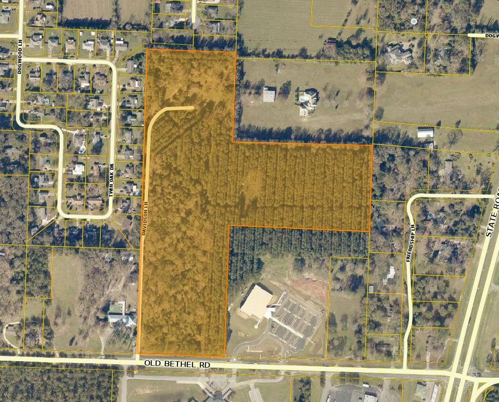
Transcription

1 CITY OF CRESTVIEW GRO WTH MA N A GE ME NT DE PARTMENT P.O. Draw er 12 09, Crestview, Flori da Phone (85 0) /161 9 Fax (850 ) LOCAL PLANNING AGENCY (P/Z BOARDS) Meeting at City Hall -- November 20, 2018 at 6:00 p.m. AGENDA 1. CONVENE Meeting. 2. APPROVE Minutes of October 16, REVIEW Application for Rezoning of acres at 6256 Davidson Lane, along Old Bethel Rd. between the Crosspoint United Methodist Church and the Lakewood Church Day School (PIN# 32-4N ). Requested by Timothy Pauls, Authorized Agent. (LPA 18-28) 4. REVIEW Request for Vacation of the undeveloped southern portion of the James Street Right-of-Way, between two parcels identified by PIN# s 08-3N and 08-3N by Bert Moore, Authorized Agent. (LPA 18-30) 5. REVIEW Application for Annexation, Comprehensive Plan Amendment, and Rezoning of 3.69 acres located at 806 James Lee Blvd. West. (PIN# s 07-3N & 18-3N ). Requested by Phillips Energy Inc., property owner, by Sandra Owens, Authorized Agent. (LPA 18-31) 6. REVIEW Site development plans submitted for Allen Turner Automotive Holdings II Inc, proposes to construct Additional Inventory Parking areas for approximately 293 automobiles on the 9.39 ± acre parcel located at/on 4150 Ferdon Blvd. South (PIN # 32-3N ). Kenneth C. Horne P.E. of Kenneth Horne & Associates Inc., Authorized Agent. (LPA-18-26) 7. REVIEW Application for Comprehensive Plan Amendment and Rezoning for a 32.0+/- acre parcel adjacent to the Davidson Middle School on Old Bethel Road (PIN 05-3N ). Requested by Betty Jean Long Trust et al, Property Owner. Matt Zinke, Jenkins Engineering, Project Engineer. (LPA 19-01) 8. CONSIDER Other Business as Necessary. 9. ADJOURN. Administrative Services Building Permits & Inspections Code Enforcement GIS Planning & Zoning
2 PLANNING & ZONING BOARD (LPA) SPECIAL MEETING OCTOBER 16, 2018 Planning & Zoning Board Members Present Members Absent Staff Visitors Ellis Conner Alton Jones Teresa Gaillard George Borinski James Skinner Mike Carroll Stephen Schoen Patti Borinski Rodney Salisbury Leon Daggs Malcolm Haynes The data reflected within these proceedings constitute an extrapolation of information elicited from notes, observations, recording tapes and photographs. Comments reflected herein are sometimes paraphrased, condensed and have been edited to reflect essential subject matter covered during the meeting. Parties interested in receiving a verbatim account of the proceedings are responsible for coordinating with the City Clerk s office and providing their own representative and equipment to produce a verbatim account of the proceedings pursuant to Crestview Policy 91 1, Duplication of Public Records, Chapters 119 and 283, Florida Statutes and Attorney General opinions in force at time of enactment of Policy CONVENE Meeting. Mr. Conner called the meeting to order at 6:28 PM. 2. APPROVE Minutes of September 25, Mr. Conner called for the approval of the minutes from September 25, Mrs. Gaillard stated that this item will be pulled due to the failure of the Public (P) Drive and that she was not able to print the minutes. Mr. Conner stated that the minutes will be taken care of at the next Local Planning Board meeting. 3. REVIEW Request for Comprehensive Plan Amendment and Rezoning of 9.99 acres located at 2704 Export Rd., South of Hugo Lane and adjacent to Export Rd. (PIN#(s) 32-3N & ). Requested by LDJ Realty Investments LLC, property owner, by Leon Daggs Jr., Authorized Agent. (LPA 18-13). Mrs. Gaillard gave a summary of the public notices and advertisements and stated that no written or verbal comments were received. She then introduced Mr. Jack Dorman to present the project summary and answer any questions. Mr. Dorman presented the project summary (see attached). Mr. Conner asked if there were any questions from the Board. There were none. Mr. Conner asked if there were any public comments or questions. There were none. Mr. Conner closed this portion of the public hearing and requested a motion. Mr. Salisbury motioned to approve, and Mr. Haynes seconded. All voted in favor. 4. REVIEW Request for Comprehensive Plan Amendment and Rezoning of a /- acre parcel located at 250 Aplin Road. (PIN# 20-3N ) Requested by George Borinski, property owner. (LPA 18-24). Mr. Conner introduced Jack Dorman. Mr. Dorman presented the project summary (see attached). Mr. Salisbury asked if the proposed change would affect any other property owner in the area. Mr. Dorman replied that it would not. Planning & Zoning Board Minutes October 16, 2018 Page 1 of 2
3 Mr. Conner asked if there were any questions or comments from the board. There were none. Mr. Conner asked if there were any questions or comments from the staff. Mrs. Gaillard stated that no written or verbal comments were received on the project. Mrs. Gaillard stated that the change would not affect any adjacent property owners. She referred to a parcel map and stated that all adjacent property surrounding the parcel was commercially zoned. Mr. Conner asked if there were any questions or comments from the audience. There were none. Mr. Conner closed this portion of the public meeting and requested a motion. Mr. Salisbury motioned to approve, and Mr. Skinner seconded. All in favor. 5. CONSIDER Other Business as Necessary. Mrs. Gaillard stated that she is actively seeking more members for the Local Planning Agency. 6. PUBLIC Comments and Questions None. 7. ADJOURN Mr. Salisbury motioned to adjourn, and Mr. Skinner seconded. The meeting adjourned at 6:41 PM. Planning & Zoning Board Minutes October 16, 2018 Page 2 of 2
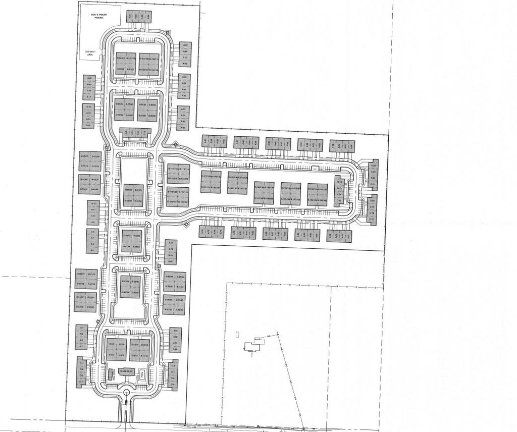
4 LPA Requested by Timothy Pauls REZONING REZONING OF APPROXIMATELY ACRES LOCATED ALONG OLD BETHEL ROAD BETWEEN THE CROSSPOINT UNITED METHODIST CHURCH AND THE LAKEWOOD CHURCH DAY SCHOOL (PIN # s 32-4N )

5
6
7 Conceptual Site Plan
8 LPA Rezoning Report Timothy Pauls, Authorized Agent Background Information Timothy Pauls, authorized agent, has submitted applications requesting the rezoning of acres, situated in Section 32, Township 4 North, Range 23 West, Okaloosa County, Florida. The acres consist of a single parcel, which is identified under Parcel Identification Numbers 32-4N , in the Public Records of Okaloosa County. The current Future Land Use classification for this parcel is Medium Density Residential (MDR) and does not currently carry a City Zoning District designation. The Future Land Use Categories, Zoning Designations and the existing use of the surrounding properties are as follows: Direction FLU Zoning Existing Use East County LDR County R-1 Single Family/Vacant South City PL City PL/C Non-residential West County LDR/PL County R-1 Single Family North County LDR County R-1 Single Family The application requests that the assignment of the Single or Multi-Family Dwelling District Zoning (R-2) designation be placed on the property. Th subject parcel has been improved by a large single-family residence. A large portion of the remaining acreage was covered in mature planted pines, which recently, have begun to be harvested. The property lies within Flood Zone X, which is an area determined to be outside the 500-year floodplain, as per the FIRM Panel Number 12091C0165H & 12091C0170H, dated The exhibits have been prepared which accurately depict the subject property. References Reviewed and Applied a. Crestview Code of Ordinances, current edition. b. Crestview Comprehensive Plan and Land Use Regulations, current edition. c. Okaloosa County Comprehensive Plan, current edition. e. Okaloosa County Land Development Regulations, current edition. Conclusion and Recommendation: The applicant has submitted the forms and has paid the application fees for the rezoning of the property. Please review the application based on the characteristics of the site and surrounding area; the nature of the development, including the land use type and densities; and conformity of the development with the City s Comprehensive Plan, the City s Code of Ordinances and other applicable state and city regulations, in deciding the pros and cons of the request. It is the recommendation of Staff that the application for Rezoning be approved. Prepared by Planning and Zoning Staff November 1, 2018
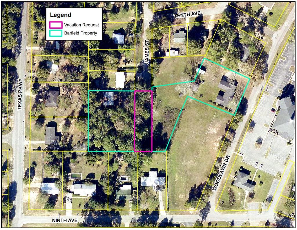
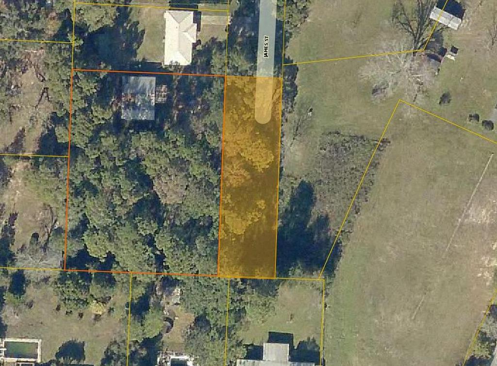
9 LPA Requested Bert Moore, Authorized Agent VACATION OF RIGHT OF WAY REQUEST FOR THE VACATION OF RIGHT OF WAY OF THE UNDEVELOPED SOUTHERN PORTION OF THE PLATTED RIGHT OF WAY OF JAMES STREET Between parcels: 08-3N & 08-3N
10
11
12
13 LPA Right-of-Way Vacation Report Bert Moore, Authorized Agent Background Information James E. Barfield has submitted an application requesting the vacation of approximately 210 linear feet of the undeveloped platted right-of-way James Street. Mr. Bert Moore, Attorney at Law, will represent Mr. Barfield as his Authorized Agent in elements concerning the vacation proceedings. James Street was created as a 60 ft. wide right of way in development of the subdivision known as the First Addition to the Jack Kennedy Addition. The right of way was dedicated to the public by the subdivision plat presented by A. J. Kennedy and Flora M. Kennedy, husband and wife, when it was recorded on January 10, 1956, in Plat Book 2, Page 104, Public Records of Okaloosa County Florida. The Subdivision is situated in Section 8, Township 3 North, Range 23 West. The undeveloped portion, which is located at the southern terminus of the James Street right-of-way, is situated between two parcels under the ownership of the applicant within the residentially developed First Addition to the Jack Kennedy Addition. The Subdivision is assigned the Low Density Residential Future Land Use Category and the Single-Family Dwelling District Zoning (R-1A). For reference, the parcels owned by the applicant are identified in the Public Records of Okaloosa County by Parcel Identification Numbers 08-3N and 08-3N The application requests that approximately 210 feet of the James Street Right-of-Way be vacated by the City of Crestview. This portion of right-of-way contains an area of 0.29 acres (12,558 square feet) and measures approximately 60 feet wide by 210 feet long. The subject portion of right-of-way remains undeveloped and unimproved. The City of Crestview is not considering any future development of public assets within this right of way. The property lies within Flood Zone X, which is an area determined to be outside the 500-year floodplain, as per the FIRM Panel Number 12091C0165H dated The exhibits have been prepared which accurately depict the subject property. References Reviewed and Applied a. Crestview Code of Ordinances, current edition. b. Crestview Comprehensive Plan and Land Use Regulations, current edition. Conclusion and Recommendation: The applicant has submitted the forms and has paid the application fees for the Right-of-Way Vacation of the subject portion of the James Street Right-of-Way. Please review the application based on the characteristics of the site and surrounding area; the nature of the request, including conformity of the vacation with the City s Comprehensive Plan, the City s Code of Ordinances and other applicable state and city regulations, in deciding the pros and cons of the request. It is the recommendation of Staff that the application for Right-of-Way Vacation be approved. Prepared by Planning and Zoning Staff November 16, 2018
14 LPA Requested by Sandra Owens, Authorized Agent for the Property Owner ANNEXATION, SMALL SCALE COMP. PLAN AMENDMENT & REZONING REQUEST FOR ANNEXATION, COMPREHENSIVE PLAN AMENDMENT AND REZONING OF 3.69 ACRES. (PIN # N & 18-3N )

15

16 Conceptual Site Plan
17 LPA Annexation Report Phillips Energy, Inc., property owner, Background Information Phillips Energy, Inc., property owner, has submitted applications requesting annexation into the jurisdictional limits of the City of Crestview, filing of a small-scale comprehensive plan amendment, and zoning designation assignment for 3.69 acres, situated in Section 7, Township 3 North, Range 23 West, and Section 18, Township 3 North, Range 23 West, Okaloosa County, Florida. The 3.69 acres consists of two parcels, which are identified under Parcel Identification Numbers 07-3N , and 18-3N in the Public Records of Okaloosa County. The parcels are contiguous to the City Limits on their Eastern and Southern boundaries. The current Okaloosa County Future Land Use classification for these parcels is Mixed Use (MU) and they carry the Mixed Use (MU) District Zoning designation. The Future Land Use Categories, Zoning Designations and the existing use of the surrounding properties are as follows: Direction FLU Zoning Existing Use East County LDR/City C County R-1/City C-1 Single Family South County MU County MU Vacant West County MU City C-1/County R-1 Vacant North Cnty. MU/Cnty. LDR Cnty. MU/Cnty. R-1 Vacant The application requests that the assignment of Commercial (C) Future Land Use Category and Commercial (C-1) District Zoning designation be placed on the property upon annexation. The subject parcels are improved. Parcel # 07-3N holds a large warehouse and parcel # 18-3N has been improved by multiple structures including a fueling station. The property lies within Flood Zone X, which is an area determined to be outside the 500-year floodplain, as per the FIRM Panel Number 12091C0165H, dated The exhibits have been prepared which accurately depict the subject property. References Reviewed and Applied a. Crestview Code of Ordinances, current edition. b. Crestview Comprehensive Plan and Land Use Regulations, current edition. c. "Policy and Procedural Guide for Processing Annexation Request or Contraction Request," current edition, and the petition of record. d. Okaloosa County Comprehensive Plan, current edition. e. Okaloosa County Land Development Regulations, current edition. Conclusion and Recommendation: The applicant has submitted the forms and has paid the application fees for the annexation, comprehensive plan amendment and rezoning of the property. Coordination with Dorman & Associates indicates the Annexation Report prepared October 26, 2018
18 associated comprehensive plan amendment should pose no problem if supported by proper documentation and Council intent. Please review the application based on the characteristics of the site and surrounding area; the nature of the development, including the land use type and densities; and conformity of the development with the City s Comprehensive Plan, the City s Code of Ordinances and other applicable state and city regulations, in deciding the pros and cons of the request. It is the recommendation of Staff that application for annexation, comp. plan amendment and rezoning be approved. Prepared by Planning and Zoning Staff Annexation Report prepared October 26, 2018
19 LPA Requested by Ken Horne of Kenneth Horne & Associates Inc. Allen Turner Chevy Additional Inventory Parking Proposed development of additional parking for approximately 293 vehicles. Located at 4150 Ferdon Blvd. South (PIN # N )

20 Proposed Development Commercial Residential Commercial Vicinity Map

21 Site Plan - Overall

22 Site Plan

23 Grading and Drainage
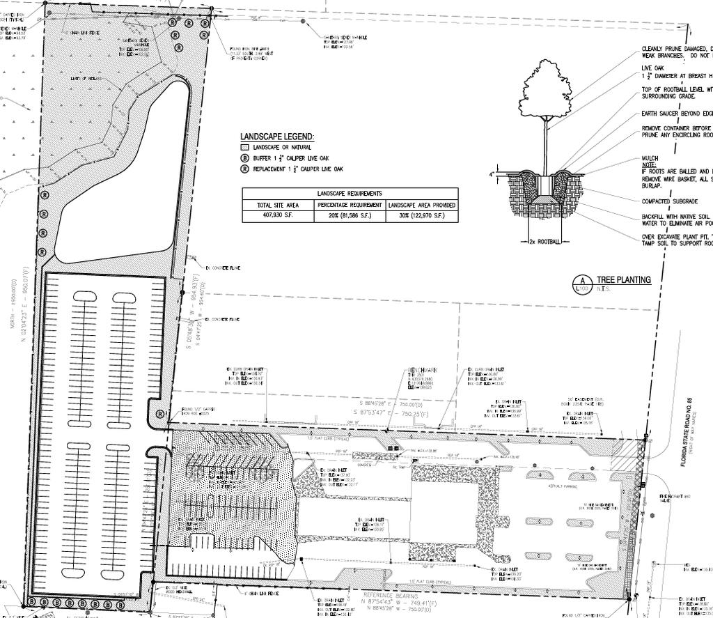
24 Landscaping
25 STAFF SUMMARY ALLEN TURNER CHEVROLET ADDITIONAL INVENTORY PARKING LPA I. Background: A. Allen Turner Automotive Holdings II Inc. proposes to construct Additional Inventory Parking areas for approximately 293 automobiles on the 9.39 ± acre parcel located at/on 4150 Ferdon Blvd. South (PIN # 32-3N ). Kenneth C. Horne P.E. of Kenneth C. Horne & Associates Inc., Authorized Agent. B. References reviewed and applied: 1. Crestview Code of Ordinances, Current Edition. 2. Crestview Comprehensive Plan, Current Edition. 3. Crestview Water & Sewer Manual, Current Edition. II. Findings: A. General: 1. The Developer has submitted the required application forms and has paid the review fees. 2. Site construction plans have been submitted for review and approval. B. Zoning: 1. The property is assigned the Future Land Use Category of Commercial (C), the Commercial Zoning District (C-1) and is adjacent to commercial uses on portions of its Northern, Southern and Eastern sides. 2. The site plan meets the required minimum setbacks. C. Reports/Permits: 1. Copies of all reports and permits shall be submitted to the City of Crestview Planning and Zoning Department. 2. Received by Public Services: a. Stormwater Management Plan and Calculations D. Concurrency: 1. The proposed Inventory Parking areas will be not connecting to the City's Water and Sanitary Sewer Systems. E. Traffic Circulation: 1. Driveway/ingress & egress a. There is a single two-way point of access to the additional inventory parking. The proposed access aisle is 26 feet in width. b. The proposed additional inventory parking located within the existing parking area will utilize the existing drive aisle with some minor reconfiguration. 2. Parking and thru-ways; a. The proposed Additional Inventory Parking area has been indicated as an employee-access-only area. There may be occasional customers that will walk in the area but the vehicles will be driven by employees.
26 1) The parking stall dimensions are indicated as nine feet by 19 feet. 2) Drive aisles within the proposed inventory parking are provided at 24 feet in width. F. Landscaping and Environmental: 1. The property frontage is 251 ± feet. The proposed development is occurring at the rear of an existing commercial use which has been previously approved with its current and existing front perimeter landscape. 2. Section requires that protected trees, if removed, shall be replaced at a ratio of one to one. a. There are 13 protected trees proposed for removal from the site, two of these trees are identified as diseased. b. The development requires 11 replacement trees for the removed protected trees. c. The landscape plan identifies the 11 required replacement trees. 3. Section requires that a landscaped buffer yard be installed between commercial and multi-family uses. a. The southern portion of the parcel abuts a multi-family use and zoning district. b. There is existing natural growth / forested area at this location which could serve as a natural landscape buffer provided it is maintained as such. c. The site plan provides for eight buffer yard trees. G. Infrastructure: 1. Project stormwater will be treated on site in a retention pond located in the northern portion of the property. a. The slope of the pond is 4:1 and shall not require fence placement. 2. Silt fencing is proposed along the entire Western property line and along portions of the Northern and Southern property lines. 3. There are no existing easements shown on the Site & Utility Plan. 4. There are Wetlands identified in the northern portion of the property, adjacent to the stormwater retention pond. a. The required 25-foot buffer is not identified. 5. Site Lighting for the proposed inventory parking areas has not been identified within the plans. This is not a public parking lot. 6. Detailed recommendations and information will be provided by the City Engineer, Public Services Department, Fire Department and the Building Official in separate documentation. III. Requirements: A. Planning and Zoning. 1. Please submit revised site plans which address the following: a. Identify the buffer yard by dimension and name to the south between the proposed use and the multi-family use. b. Identify the required 25-foot wetland buffer by dimension and name. 2. A separate permit, outside of the Development Order process, will be required prior to the construction of all proposed walls and/or fences. Page 2
27 3. A separate permit shall be required if removal of any protected trees on site is desired prior to Development Order approval. 4. The City requires copies of all outside agency permit(s). B. Public Services. 1. Public Services comments will be provided in separate documentation. C. Fire Department. 1. No comments. IV. Recommendations: A. Review project for compliance with above cited references and other applicable codes. Page 3
 TRC Meeting Date: 11-13-18 Engineer: Kenneth Horne &")
28 November 7, 2018 Wayne Steele Director of Public Services 715 N. Ferdon Blvd. Crestview, Florida REF: Allen Turner Chevrolet Additional Inventory Parking Preliminary Site Plans Review (Plans received ) TRC Meeting Date: Engineer: Kenneth Horne & Associates, Inc. Pensacola, Florida Following are the Engineering Review comments on the referenced project plans and calculations submitted. 1. The project consists of modifying the existing Allen Turner Chevrolet site and constructing Additional Inventory Parking areas for approximately 293 automobiles. The proposed improvements do not include any water and/or sewer connections or modifications to existing utilities. 2. Please provide a Site Data Table to include overall Floor Area Ratio (FAR) and Impervious Surface Coverage (ISC) information for the entire site (including the existing development site). 3. The Stormwater Calculations have been received and reviewed but are not approved at this time. The Geotechnical Report included with the stormwater calculations appears to be missing the odd numbered pages. Due to the missing pages, we do not have a Boring Location Plan and other pertinent information necessary to complete our review of the calculations and plans. Please provide a complete copy of the Stormwater calculations including the complete Geotechnical Report. 4. Please demonstrate that adequate separation between the bottom of the pond filter and the SHGWT is provided. 5. Please provide details for storm structure ST-17 and provide riprap to dissipate the discharge from the dry retention pond. Please call me if you have any additional comments or questions. Sincerely, Timothy D. Bowden, P.E., P.S.M Highway 189 N Baker, FL Phone (850) Fax (850)
29 LPA Requested by Betty Jean Long Trust et al, Property Owner Matt Zinke, Jenkins Engineering, Project Engineer Comprehensive PLAN AMENDMENT & REZONING REQUEST FOR COMPREHENSIVE PLAN AMENDMENT AND REZONING OF 32+/- ACRES FROM COMMERCIAL TO RESIDENTIAL (PIN # N )

30

31
32
CITY OF BELLEVIEW PLANNING & ZONING BOARD AGENDA
 CITY OF BELLEVIEW PLANNING & ZONING BOARD AGENDA BELLEVIEW CITY HALL COMMISSION ROOM 5:30 PM IF A PERSON SHOULD DESIRE TO APPEAL ANY DECISION MADE BY THE BOARD, A VERBATIM RECORD OF THE PROCEEDINGS WHICH
MINUTES OF THE TOWN OF LADY LAKE REGULAR PLANNING AND ZONING BOARD MEETING LADY LAKE, FLORIDA. May 8, :30 p.m.
 MINUTES OF THE TOWN OF LADY LAKE REGULAR PLANNING AND ZONING BOARD MEETING LADY LAKE, FLORIDA May 8, 2017 5:30 p.m. The Planning and Zoning Board Meeting was held in the Town Hall Commission Chambers at
Town of Cary, North Carolina Rezoning Staff Report 12-REZ-27 Morris Branch Town Council Public Hearing January 24, 2013
 Town of Cary, North Carolina Rezoning Staff Report 12-REZ-27 Morris Branch Town Council Public Hearing January 24, 2013 REQUEST To amend the Town of Cary Official Zoning Map to rezone approximately 9.0
CITY OF BONITA SPRINGS ZONING ORDINANCE NO
 CITY OF BONITA SPRINGS ZONING ORDINANCE NO. 06-05 A ZONING ORDINANCE OF THE CITY OF BONITA SPRINGS, FLORIDA; APPROVING A REQUEST BY NAPITA HOLDINGS, LLC IN REFERENCE TO BONITA ROAD LOCKUP CPD; TO REZONE
EXHIBIT D. WRITTEN DESCRIPTION For. TOWNSEND VILLAGE PUD December 23, 2015 (Revised)
") I. PROJECT DESCRIPTION EXHIBIT D WRITTEN DESCRIPTION For TOWNSEND VILLAGE PUD December 23, 2015 (Revised) A. This 7.2 acre single-family residential project is located on the East side of Townsend Boulevard,
I. PROJECT DESCRIPTION EXHIBIT D WRITTEN DESCRIPTION For TOWNSEND VILLAGE PUD December 23, 2015 (Revised) A. This 7.2 acre single-family residential project is located on the East side of Townsend Boulevard,
Town of Cary, North Carolina Rezoning Staff Report 14-REZ-31 Cary Park PDD Amendment (Waterford II) Town Council Meeting January 15, 2015
 Town Council Meeting January 15, 2015") Town of Cary, North Carolina Rezoning Staff Report 14-REZ-31 Cary Park PDD Amendment (Waterford II) Town Council Meeting January 15, 2015 REQUEST To amend the Town of Cary Official Zoning Map by amending
Town of Cary, North Carolina Rezoning Staff Report 14-REZ-31 Cary Park PDD Amendment (Waterford II) Town Council Meeting January 15, 2015 REQUEST To amend the Town of Cary Official Zoning Map by amending
Town of Cary, North Carolina Rezoning Staff Report 14-REZ-24 Indian Wells Road Properties Town Council Meeting November 20, 2014
 Town of Cary, North Carolina Rezoning Staff Report 14-REZ-24 Indian Wells Road Properties Town Council Meeting November 20, 2014 REQUEST To amend the Town of Cary Official Zoning Map by revising a condition
Parkland-Spanaway-Midland LUAC - Agenda
 1. 6:30 P.M. Parkland-Spanaway-Midland LUAC - Agenda Documents: 8 2 17 PSMAC Agenda.pdf 2. Parkland-Spanaway-Midland LUAC Initial Project Review Documents: Lincoln Court PP IPR PSMAC-RJ.pdf Department
PLANNING COMMISSION MEETING November 6, :00 P.M. COMMISSION ROOM/CITY HALL AGENDA
 City of Auburndale Auburndale, Florida 33823 #1 Bobby Green Plaza P. O. Box 186 Community Development Department Phone (863) 965-5530 Fax (863) 965-5507 PLANNING COMMISSION MEETING 4:00 P.M. COMMISSION
31, Township 29 South, Range 25 East, Polk County, Florida, as depicted by the Land Use Plan attached
 ORDINANCE NO. 2013-04 AN ORDINANCE AMENDING THE ZONING MAP OF THE CITY OF BARTOW, FLORIDA, REZONING APPROXIMATELY 2. 2 ACRES OF LAND OWNED BY BALA3I OF POLK COUNTY, LLC AND LOCATED IN SECTION 31, TOWNSHIP
EXHIBIT D. Planned Unit Development Written Description April 13, 2016 Rouen Cove Phase II PUD
 1 EXHIBIT D Planned Unit Development Written Description April 13, 2016 Rouen Cove Phase II PUD Development # 8986.001 Developer: Curtis L. Hart Hart Resources LLC 8051 Tara Lane Jacksonville, Florida
Town of Cary, North Carolina Rezoning Staff Report 14-REZ-20 Habitat for Humanity Evans Road Town Council Meeting October 16, 2014
 Town of Cary, North Carolina Rezoning Staff Report 14-REZ-20 Habitat for Humanity Evans Road Town Council Meeting October 16, 2014 REQUEST To amend the Town of Cary Official Zoning Map by rezoning 0.53
Lake County Planning, Building and Development Department
 SUBMISSION CHECKLIST FOR SUBDIVISION FINAL PLAT Lake County Planning, Building and Development Department 500 W. Winchester Rd. Unit 101 Libertyville, Illinois 60048-1331 Telephone (847) 377-2600 E-mail:
Marion County Board of County Commissioners
 Marion County Board of County Commissioners Date: 12/2/2015 P&Z: 11/30/2015 BCC: 12/16/2015 Item Number 151210SU Type of Application Special Use Permit Request To establish a Clay Electric Co-Operative
Plans shall be drawn at a readable scale, signed, and sealed by a Florida Registered Engineer. The application package shall include:
 CHAPTER 400. SECTION 403. PERMIT TYPES AND APPLICATIONS SITE DEVELOPMENT 403.3. Preliminary Site Plans (PSP) A. Intent and Purpose PSPs are used to identify existing site conditions and demonstrate general
Staff Report: Date: Applicant: Property Identification: Acreage of Request: Current Zoning of Requested Area: Requested Action: Attached:
 Staff Report: Completed by Jeff Palmer Director of Planning & Zoning Date: November 7, 2018, Updated November 20, 2018 Applicant: Greg Smith, Oberer Land Developer agent for Ronald Montgomery ET AL Property
ARTICLE 9 SPECIFICATIONS FOR DOCUMENTS TO BE SUBMITTED
 ARTICLE 9 SPECIFICATIONS FOR DOCUMENTS TO BE SUBMITTED SECTION 950 GENERALLY All applications shall be properly signed and filed by the owner or, with the owner s specific written consent, a contract purchaser
COMPREHENSIVE PLAN FUTURE LAND USE MAP AMENDMENT APPLICATION
 COUNTY STAFF DATA ONLY Date Received: Project No. CPA-20 - GADSDEN COUNTY DEPARTMENT OF PLANNING & COMMUNITY DEVELOPMENT 1-B East Jefferson Street, Post Office Box 1799, Quincy, FL 32353-1799 PLANNING
SUBJECT PARCEL(S) Property Owner(s) TMS Number Approximate Acreage Carolina Park Development, LLC
 Property Owner(s) TMS Number Approximate Acreage Carolina Park Development, LLC") Staff Report Special Planning Commission Meeting November 19, 2014 For reference, the Zoning Code and Land Development Regulations are available online. AGENDA ITEM 5c. SKETCH PLAN APPROVAL REQUEST: Request
Staff Report Special Planning Commission Meeting November 19, 2014 For reference, the Zoning Code and Land Development Regulations are available online. AGENDA ITEM 5c. SKETCH PLAN APPROVAL REQUEST: Request
Charter Township of Garfield Grand Traverse County
 Charter Township of Garfield Grand Traverse County 3848 VETERANS DRIVE TRAVERSE CITY, MICHIGAN 49684 PH: (231) 941-1620 FAX: (231) 941-1588 GUIDE FOR THE SUBMISSION OF AN APPLICATION FOR SITE PLAN REVIEW
PLANNED UNIT DEVELOPMENT & SUBDIVISION STAFF REPORT Date: April 18, 2019
 PLANNED UNIT DEVELOPMENT & SUBDIVISION STAFF REPORT Date: April 18, 2019 DEVELOPMENT NAME SUBDIVISION NAME Springhill Village Subdivision Springhill Village Subdivision LOCATION 4350, 4354, 4356, 4358,
CITY OF OCOEE LAND DEVELOPMENT CODE SUFFICIENCY TABLE WITH NOTES
 CITY OF OCOEE LAND DEVELOPMENT CODE SUFFICIENCY TABLE WITH NOTES The Sufficiency Table is a checklist to help identify the types of information and documentation needed for various types of projects. The
Marion County Board of County Commissioners
 Marion County Board of County Commissioners Date: 6/4/217 P&Z: 9/25/217 BCC Transmittal: 1/17/217 BCC Adopt: TBD Amendment No: 217-L6 Type of Application Large-Scale Comp Plan Amendment Request: Change
Planning Department Oconee County, Georgia STAFF REPORT
 Planning Department Oconee County, Georgia STAFF REPORT REZONE CASE #: 7332 DATE: November 28, 2017 STAFF REPORT BY: Gabriel Quintas, Planner APPLICANT NAME: Smith Planning Group PROPERTY OWNER: John Hadden
THE AREA PLAN COMMISSION OF ST. JOSEPH COUNTY, IN AGENDA
 THE AREA PLAN COMMISSION OF ST. JOSEPH COUNTY, IN AGENDA Tuesday, June 20, 2017 Fourth-Floor Council Chambers 3:30 p.m. County-City Building, South Bend, IN PUBLIC HEARINGS: 1. Rezonings: A. A combined
Marion County Board of County Commissioners
 Marion County Board of County Commissioners Date: 12/29/2015 P&Z: 12/28/2015 BCC: 1/12/2016 Item Number 160113Z Type of Application Rezoning Request From: A-1 (General Agriculture) To: PUD (Planned Unit
CITY OF LABELLE ORDINANCE BROWARD AVE LLC PLANNED UNIT DEVELOPMENT REZONE
 CITY OF LABELLE ORDINANCE 2019-04 BROWARD AVE LLC PLANNED UNIT DEVELOPMENT REZONE AN ORDINANCE OF THE CITY OF LABELLE, FLORIDA, AMENDING THE CITY OF LABELLE ZONING MAP FOR PROPERTY LOCATED SOUTH OF BROWARD
CHECKLIST FOR DEVELOPMENT REVIEW
 CHECKLIST FOR DEVELOPMENT REVIEW Petitions and related documents and plans for land development or other proposals regulated by Title 16 of the Municipal Code (Development Ordinance) and Title 17 of the
Gadsden County Planning Commission Agenda Report
 Gadsden County Planning Commission Agenda Report Date of Meeting: June 16, 2016 To: From: Subject: Honorable Chairperson and Members of the Planning Commission Allara Mills Gutcher, AICP, Planning & Community
ZONING AMENDMENT & SUBDIVISION STAFF REPORT Date: July 9, 2015
 ZONING AMENDMENT & SUBDIVISION STAFF REPORT Date: July 9, 2015 APPLICANT NAME 2513 Dauphin Street, Inc. SUBDIVISION NAME Audubon Place Extension No. 3, Resubdivision of Lots 1-5 LOCATION 2513 Dauphin Street
MINUTE ORDER BONNER COUNTY COMMISSIONERS PUBLIC HEARING MINUTES AUGUST 6, 2015
 MINUTE ORDER BONNER COUNTY COMMISSIONERS PUBLIC HEARING MINUTES AUGUST 6, 2015 CALL TO ORDER: Chair Cary Kelly called the Bonner County Commissioners hearing to order at 1:00 p.m. in the 3rd floor meeting
City of Sanibel. Planning Department STAFF REPORT
 City of Sanibel Planning Department STAFF REPORT Planning Commission Meeting: July 23, 2013 Planning Commission Agenda Item: No 7b. Application Number: 13-7438DP Applicant Name: Attorney Beverly Grady
APPLICATION REVIEW CHECKLISTS
 APPLICATION REVIEW CHECKLISTS The following must be submitted with and are part of each application. No application is complete until all required documentation has been submitted to the Community Development
INDIAN RIVER COUNTY, FLORIDA. The Honorable Members of the Planning and Zoning Commission DEPARTMENT HEAD CONCURRENCE
 Public Hearing Legislative INDIAN RIVER COUNTY, FLORIDA M E M O R A N D U M TO: The Honorable Members of the Planning and Zoning Commission DEPARTMENT HEAD CONCURRENCE Robert M. Keating, AICP; Community
ARTICLE 14 PLANNED UNIT DEVELOPMENT (PUD) DISTRICT
 DISTRICT") ARTICLE 14 PLANNED UNIT DEVELOPMENT (PUD) DISTRICT Section 14.01 Intent. It is the intent of this Article to allow the use of the planned unit development (PUD) process, as authorized by the Michigan Zoning
ARTICLE 14 PLANNED UNIT DEVELOPMENT (PUD) DISTRICT Section 14.01 Intent. It is the intent of this Article to allow the use of the planned unit development (PUD) process, as authorized by the Michigan Zoning
Initial Project Review
 Pierce County Department of Planning and Land Services, 2401 South 35th Street, Tacoma, WA (253) 798-7037 Initial Project Review Major Amendment to Preliminary Plat: Hawks Ridge Division 1 Application
TOWNSHIP OF SALISBURY LEHIGH COUNTY, PENNSYLVANIA. PLANNING COMMISSION MEETING MINUTES November 14, 2017 START TIME 7:30 PM
 TOWNSHIP OF SALISBURY LEHIGH COUNTY, PENNSYLVANIA PLANNING COMMISSION MEETING MINUTES November 14, 2017 START TIME 7:30 PM The regularly scheduled public meeting of the Salisbury Township Planning Commission
DEVELOPMENT PLAN REVIEW CHECKLIST. To initiate the application, the applicant shall submit to the Administrative Officer:
 DEVELOPMENT PLAN REVIEW CHECKLIST To initiate the application, the applicant shall submit to the Administrative Officer: 1. Sixteen (16) copies of the Project Review Application Form, printed double-sided;
ARTICLE Encourage well planned, efficient development.
 ARTICLE 14.00 PD PLANNED SECTIONS: 14.01 Intent 14.02 Procedure 14.03 Initial Development Plan 14.04 Final Development Plan 14.05 Amendments 14.06 Planned Development Districts PD-1 Willow Run PD PD-2
Residential Minor Subdivision Review Checklist
 Residential Minor Subdivision Review Checklist Plan Submittal Requirements: 2 full sets of stamped plans Electric submittal - all plans contained in a single PDF 3 full sets if commercial kitchen or dining
WESTMINSTER PARK SUBDIVISION
 WESTMINSTER PARK SUBDIVISION Engineering Comments: FINAL PLAT COMMENTS (should be addressed prior to submitting the FINAL PLAT for review and/or signature by the City Engineer): A. Provide all of the required
Medical Marijuana Special Exception Use Information
 Medical Marijuana Special Exception Use Information The Special Exception Use information below is a modified version of the Unified Development Code. It clarifies the current section 5:104 Special Exceptions
CONCEPTUAL MASTER PLAN CHECKLIST Major Land Development Project
 CONCEPTUAL MASTER PLAN CHECKLIST Major Land Development Project To initiate the application, the applicant shall submit to the Administrative Officer: 1. The application review fee, as established by the
ARTICLE 13 CONDOMINIUM REGULATIONS
 ARTICLE 13 CONDOMINIUM REGULATIONS Section 13.01 Purpose. The purpose of this Article is to regulate projects that divide real property under a contractual arrangement known as a condominium. New and conversion
Appendix J - Planned Unit Development (PUD)
") Appendix J - Planned Unit Development (PUD) Intent and Purpose The purpose of the PUD is: 1. To provide development that is consistent with the Comprehensive Land Use Plan and promote the goals and objectives
Appendix J - Planned Unit Development (PUD) Intent and Purpose The purpose of the PUD is: 1. To provide development that is consistent with the Comprehensive Land Use Plan and promote the goals and objectives
Staff Report: Date: Applicant: Property Identification: Acreage of Request: Current Zoning of Requested Area: Requested Action: Attached:
 Staff Report: Completed by Jeff Palmer Director of Planning & Zoning Date: November 7, 2018 Applicant: Greg Smith, Oberer Land Developer agent for Ronald Montgomery ET AL Property Identification: Frontage
Residential Major Subdivision Review Checklist
 Residential Major Subdivision Review Checklist Plan Submittal Requirements: 2 full sets of stamped plans Electric submittal - all plans contained in a single PDF 3 full sets if commercial kitchen or dining
November 9, 2016 Ponderay Planning and Zoning Commission File AX Annexation Request Thomas L. Clark. Preliminary Survey of Subject Parcel
 Ponderay - City Planning Staff Report November 9, 2016 Ponderay Planning and Zoning Commission File AX16-013 Annexation Request Thomas L. Clark Subject Parcels Preliminary Survey of Subject Parcel Project
SUBDIVISION APPLICATION CHECKLIST SKETCH PLAN PRELIMINARY PLAT FINAL PLAT
 RECEIVED STAMP SUBDIVISION APPLICATION CHECKLIST SKETCH PLAN PRELIMINARY PLAT FINAL PLAT A checklist of background information and submission requirements for processing of a sketch plan, preliminary plat
CITY OF MURFREESBORO BOARD OF ZONING APPEALS
 CITY OF MURFREESBORO BOARD OF ZONING APPEALS Regular Meeting, July 27, 2011, at 1:00 p.m. City Hall, 111 West Vine Street, Council Chambers, 1 st Floor 1. Call to order A G E N D A 2. Consideration of
PALM BEACH COUNTY PLANNING, ZONING AND BUILDING DEPARTMENT ZONING DIVISION
 PALM BEACH COUNTY PLANNING, ZONING AND BUILDING DEPARTMENT ZONING DIVISION Application No.: CA-2012-00688 Control No.: 2011-00552 Applicant: Garry Bernardo Owners: Garry Bernardo Agent: Frogner Consulting,
Village of Cazenovia Zoning Board of Appeals August 12, 2014
 Village of Cazenovia Zoning Board of Appeals August 12, 2014 FINAL - 1 - Village of Cazenovia Zoning Board of Appeals August 12, 2014 5 10 Members Present: Phil Byrnes, Chair; Sally Ryan; William Keiser;
1. Roll Call. 2. Minutes a. September 26, 2016 Regular Meeting. 3. Adoption of the Agenda. 4. Visitors to Be Heard
 1. Roll Call City of Vermillion Planning Commission Agenda 5:30 p.m. Regular Meeting Tuesday, October 11, 2016 Large Conference Room 2 nd Floor City Hall 25 Center Street Vermillion, SD 57069 2. Minutes
CITY OF ALBERT LEA PLANNING COMMISSION ADVISORY BOARD
 CITY OF ALBERT LEA PLANNING COMMISSION ADVISORY BOARD 9/1/2015, 5:30 p.m. City Council Chambers AGENDA A. CALL TO ORDER AND ROLL CALL B. APPROVAL OF THE AGENDA C. APPROVAL OF MINUTES 1. PC Minutes from
Planning Department Oconee County, Georgia
 Planning Department Oconee County, Georgia STAFF REPORT REZONE CASE #: 6985 DATE: October 31, 2016 STAFF REPORT BY: Andrew C. Stern, Planner APPLICANT NAME: Williams & Associates, Land Planners PC PROPERTY
ZONING AMENDMENT & SUBDIVISION STAFF REPORT Date: November 3, 2016
 ZONING AMENDMENT & SUBDIVISION STAFF REPORT Date: November 3, 2016 APPLICANT NAME SUBDIVISION NAME David Shumer 5955 Airport Subdivision CITY COUNCIL DISTRICT District 6 5955 Airport Boulevard, 754 Linlen
MINUTES. May 1, Chairman Smith called the City Plan Commission Meeting to order at 7 p.m.in the City Council Chambers.
 MINUTES May 1, 2018 Chairman Smith called the City Plan Commission Meeting to order at 7 p.m.in the City Council Chambers. The following Commission members were in attendance: Michael Smith, Chairman Ken
PORT CITY COMMERCE PARK SUBDIVISION
 # 4 SUB2015-00019 PORT CITY COMMERCE PARK SUBDIVISION Engineering Comments: Must comply with the Mobile County Flood Damage Prevention Ordinance. Development shall be designed to comply with the storm
FINAL SUBDIVISION AND LAND DEVELOPMENT PLAN CHECKLIST. Plan Name. Applicant's Name:
 TOWNSHIP OF UPPER ST. CLAIR FINAL SUBDIVISION AND LAND DEVELOPMENT PLAN CHECKLIST Date Filed Plan Name PLC Applicant's Name: Phone Filing Date for Final Application Final Plat 114.22. FINAL APPLICATION
CONDOMINIUM REGULATIONS
 ARTICLE 37 CONDOMINIUM REGULATIONS SECTION 37.01. Purpose The purpose of this Article is to regulate projects that divide real property under a contractual arrangement known as a condominium. New and conversion
Article 6: Planned Unit Developments
 LUDC 2013 GARFIELD COUNTY, COLORADO Article 6: Planned Unit Developments ARTICLE 6 PLANNED UNIT DEVELOPMENTS TABLE OF CONTENTS DIVISION 1. GENERAL.... 1 6-101. GENERAL PROVISIONS.... 1 A. Purpose....
CITY OF MURFREESBORO BOARD OF ZONING APPEALS
 CITY OF MURFREESBORO BOARD OF ZONING APPEALS Regular Meeting, September 26, 2012, at 1:00 p.m. City Hall, 111 West Vine Street, Council Chambers, 1 st Floor 1. Call to order A G E N D A 2. Consideration
1. APPLICANT: Polsinelli, Shalton & Welte is the applicant for this request.
 5. REVISED PRELIMINARY PLAN APPROVAL - THE RETREAT AT MAPLECREST - Vicinity of the northeast corner of 159 th Street and U.S. 69 Highway 1. APPLICANT: Polsinelli, Shalton & Welte is the applicant for this
APPLICATION FOR ZONING CHANGE
 PROPERTY DESCRIPTION APPLICANT/AGENT PROPERTY OWNER(S) Application # APPLICATION FOR ZONING CHANGE Date of Application Name(s): Mailing Address: City: State: Zip: Telephone Number: Fax #: E-mail Address:
ZONING AMENDMENT, PLANNED UNIT DEVELOPMENT & SUBDIVISION STAFF REPORT Date: August 8, 2013
 ZONING AMENDMENT, PLANNED UNIT DEVELOPMENT & SUBDIVISION STAFF REPORT Date: August 8, 2013 NAME SUBDIVISION NAME PV-Magnolia, LLC Twelve Trees Subdivision LOCATION 2860, 2862 and 2866 Pleasant Valley Road
COMMUNITY MEETING EXHIBITS
 COMMUNITY MEETING EXHIBITS EXHIBIT 1 : Meeting Agenda EXHIBIT 2 : Presentation Posters EXHIBIT 3 : Attendance Sign-In Sheet EXHIBIT 4 : Letters to Property Owners EXHIBIT 5 : Photos of Meeting EXHIBIT
Department of Planning & Development Services
 Department of Planning & Development Services S T A F F R E P O R T February 9, 2015 CASE NO: PROJECT: EXECUTIVE SUMMARY: ZA14-154 Plat Revision for Lots 25R-1A, 25R-1B and 25R-1C, Block 1, Woodland Heights
SUBMITTAL REQUIREMENTS: The number indicates the number of copies for submittal (if applicable).
.") Office Use Only Preliminary Long Plat Long Subdivision Applicant Checklist PLANNING, COMMUNITY, & ECONOMIC DEVELOPMENT DEPARTMENT PRELIMINARY LONG PLAT LONG SUBDIVISION CHECKLIST Mailing Address: P.O.
Office Use Only Preliminary Long Plat Long Subdivision Applicant Checklist PLANNING, COMMUNITY, & ECONOMIC DEVELOPMENT DEPARTMENT PRELIMINARY LONG PLAT LONG SUBDIVISION CHECKLIST Mailing Address: P.O.
MEMBERS PRESENT: Darrin Buskirk, Buan Smith, Chris Cobbler, Mitzi Delius, Jeri Hartley, J. Smith, Bruce Southworth, Pattie Wilson
 ON TUESDAY, JANUARY 19, 2016 THE TECHNICAL REVIEW COMMITTEE HELD THEIR MEETING AT 10:00 A.M. IN THE 2 ND FLOOR COURTROOM OF THE WOODFORD COUNTY COURTHOUSE. MEMBERS PRESENT: Darrin Buskirk, Buan Smith,
Site Plan Application
 Site Plan Application City of St. Pete Beach Community Development Department 155 Corey Avenue St. Pete Beach, Florida 33706 (727) 367-2735 www.stpetebeach.org Case Number: PROPERTY OWNER: Name: Address:
APPLICATION FOR DEVELOPMENT AGREEMENT
 APPLICATION FOR DEVELOPMENT AGREEMENT To be Completed by City Clerk Application No. Date Received: Received by: Please submit a completed application to the Planning Department for payment and meeting
PRELIMINARY PLAN CHECKLIST Major Land Development Projects. To initiate the application, the applicant shall submit to the Administrative Officer:
 PRELIMINARY PLAN CHECKLIST Major Land Development Projects To initiate the application, the applicant shall submit to the Administrative Officer: 1. The application review fee, as established by the South
PLANNED UNIT DEVELOPMENTS
 PLANNED UNIT DEVELOPMENTS SECTION 9.01 DESCRIPTION AND PURPOSE. A. The purpose of a planned unit development (PUD) is to permit greater flexibility in development than is generally possible under standard
GWINNETT COUNTY CSO CONSERVATION SUBDIVISION OVERLAY DISTRICT REQUIREMENTS
 GWINNETT COUNTY CSO CONSERVATION SUBDIVISION OVERLAY DISTRICT REQUIREMENTS Section 1316. CSO Conservation Subdivision Overlay District. 1. Purposes. The purposes of this overlay district are as follows:
DOÑA ANA COUNTY PLANNING AND ZONNING COMMISSION
 DOÑA ANA COUNTY PLANNING AND ZONNING COMMISSION Doña Ana County Government Complex 845 N. Motel Blvd. Las Cruces, New Mexico 88007 Office: (575) 647-7350 MEETING DATE: June 22, 2017 REQUEST: Variance CASE
AGENDA PLANNING AND ZONING BOARD CITY OF DEERFIELD BEACH, FLORIDA May 2, 2013
 AGENDA PLANNING AND ZONING BOARD CITY OF DEERFIELD BEACH, FLORIDA May 2, 2013 The following is the agenda of a regular meeting of the Planning and Zoning Board of the City of Deerfield Beach, a municipal
MINUTES OF THE TOWN OF LADY LAKE REGULAR PLANNING AND ZONING BOARD MEETING LADY LAKE, FLORIDA. February 8, :30pm
 MINUTES OF THE TOWN OF LADY LAKE REGULAR PLANNING AND ZONING BOARD MEETING LADY LAKE, FLORIDA 5:30pm The Planning and Zoning Board Meeting was held in the Town Hall Commission Chambers at 409 Fennell Blvd.,
Town of Cary, North Carolina Rezoning Staff Report 13-REZ-13 An Zou Property Town Council Meeting November 21, 2013
 Town of Cary, North Carolina Rezoning Staff Report 13-REZ-13 An Zou Property Town Council Meeting November 21, 2013 REQUEST To amend the Town of Cary Official Zoning Map by rezoning 0.63 acres located
FUTURE LAND USE. City of St. Augustine Comprehensive Plan EAR-Based Amendments
 FUTURE LAND USE City of St. Augustine Comprehensive Plan EAR-Based Amendments Future Land Use Element FLU Goal To create an environment within the City and adjacent areas in which its residents have the
Planned Residential Development ( PRD ) Application
 Application") FOR PLANNING USE ONLY Application # PRD Application Fee $ Receipt No. Filing Date Completeness Date Planned Residential Development ( PRD ) Application A. PROJECT INFORMATION 1. Project Name: 2. Address
FOR PLANNING USE ONLY Application # PRD Application Fee $ Receipt No. Filing Date Completeness Date Planned Residential Development ( PRD ) Application A. PROJECT INFORMATION 1. Project Name: 2. Address
A favorable recommendation to the City Council is requested.
 To: Sycamore Plan Commission From: Brian Gregory, City Manager Date: November 9, 2017 Re: November 13, 2017 Plan Commission Meeting The Plan Commission has one action item and three workshop items. I.
AGENDA ITEM SUMMARY GLADES COUNTY BOARD OF COUNTY COMMISSIONERS
 AGENDA ITEM SUMMARY GLADES COUNTY BOARD OF COUNTY COMMISSIONERS SUBJECT: Case Number COMP17-01, Legend Moto LLC This is a Legislative Hearing. DEPARTMENT REQUEST: The Community Development Department requests
Condominium Unit Requirements.
 ARTICLE 19 CONDOMINIUM REGULATIONS Section 19.01 Purpose. The purpose of this Article is to regulate projects that divide real property under a contractual arrangement known as a condominium. New and conversion
Planning Commission Preliminary Plan LRC Subdivision Montville Township
 Planning Commission Preliminary Plan LRC Subdivision Montville Township Meeting: February 1, 2017 App. No.: 002-2017-PP Owner: Faith & Hope Land Dev. Co. Applicant: Montville Investors LLC Engineer: Weber
In order to permit maximum applicability of the PUD District, PUD-1 and PUD-2 Districts are hereby created.
 ARTICLE III. PUD ned Unit Development Overlay District 205-128. Purpose. The PUD ned Unit Development Overlay District is intended to provide flexibility in the design of planned projects; to encourage
CITY OF EL MIRAGE DEVELOPMENT APPLICATION PROCESS
 DEVELOPMENT APPLICATION PROCESS I. Technical Advisory Committee (TAC) 1. Submit TAC Review Application (See Page 3 for TAC Review Application Requirements) 2. Review of TAC Review Application by Technical
Report to the Plan Commission February 4, 2013
 Report to the Plan Commission Legistar I.D. #28789 Conditional Use Requested Actions: Approval of a conditional use for a structure exceeding 10,0000 square feet of total floor area and an accessory building
PALM BEACH COUNTY PLANNING, ZONING AND BUILDING DEPARTMENT ZONING DIVISION
 PALM BEACH COUNTY PLANNING, ZONING AND BUILDING DEPARTMENT ZONING DIVISION Application No.: Z-2016-00663 Application Name: Autism School Control No.: 2014-00133 Applicant: Dayna2, LLC Owners: Dayna2, LLC
VILLAGE OF ORLAND PARK
 14700 Ravinia Avenue Orland Park, IL 60462 www.orlandpark.org Ordinance No: File Number: 2016-0865 ORDINANCE REZONING CERTAIN REAL ESTATE FROM E-1 ESTATE RESIDENTIAL DISTRICT TO COR MIXED USE DISTRICT
TO: Glynn County Islands Planning Commission. Eric Landon, Planner II. PP2754 Stones Throw Cottages. DATE: February 6, 2014
 COMMUNITY DEVELOPMENT DEPARTMENT Planning and Zoning Division 1725 Reynolds Street, Suite 200, Brunswick, GA 31520 Phone: 912-554-7428/Fax: 1-888-252-3726 TO: Glynn County Islands Planning Commission FROM:
DAWES SWITCHING STATION SUBDIVISION
 DAWES SWITCHING STATION SUBDIVISION Engineering Comments: Must comply with the Mobile County Flood Damage Prevention Ordinance. Development shall be designed to comply with the storm water detention and
Cover Letter with Narrative Statement
 Cover Letter with Narrative Statement March 31, 2017 rev July 27, 2017 RE: Rushton Pointe Residential Planned Unit Development Application for Public Hearing for RPUD Rezone PL2015 000 0306 Mr. Eric Johnson,
AUTUMNDALE SUBDIVISION, RESUBDIVISION OF LOTS
 AUTUMNDALE SUBDIVISION, RESUBDIVISION OF LOTS 100-102 Engineering Comments: Road shall be constructed per City standards and according to the City s street acceptance process. Cul-de sac approval subject
SOUTHERN INDUSTRIAL PARK SUBDIVISION, LOT A, RESUBDIVISION OF LOTS 7 & 8
 SOUTHERN INDUSTRIAL PARK SUBDIVISION, LOT A, RESUBDIVISION OF LOTS 7 & 8 Engineering Comments: Need to increase width of existing easement to include an area at least 20 from the top of the existing ditch,
Town of Cary, North Carolina Rezoning Staff Report. 956 W. Chatham Street. Town Council Meeting January 9, 2014
 Town of Cary, North Carolina Rezoning Staff Report 13-REZ-22 956 W. Chatham Street Town Council Meeting January 9, 2014 REQUEST To amend the Town of Cary Official Zoning Map by rezoning 0.85 acres located
CHAPTER34 PRUD - PLANNED RESIDENTIAL UNIT DEVELOPMENT
 CHAPTER34 PRUD - PLANNED RESIDENTIAL UNIT DEVELOPMENT 17-34-1 17-34-2 17-34-3 17-34-4 17-34-5 17-34-6 17-34-7 17-34-8 17-34-9 Purpose Planned Residential Unit Development Defined Planned Residential Unit
CITY OF SURREY BY-LAW NO A by-law to amend Surrey Zoning By-law, 1993, No , as amended...
 CITY OF SURREY BY-LAW NO. 17420 A by-law to amend Surrey Zoning By-law, 1993, No. 12000, as amended........................................................... THE CITY COUNCIL of the City of Surrey, in
REPORT TO THE PLANNING COMMISSION
 Agenda Number: PC14-50 MEETING DATE: February 5, 2015 REPORT TO THE PLANNING COMMISSION SUBJECT: Villas of Tara Oaks Request approval of a Preliminary Subdivision Plat for 29 lots, on 9.14 acres located
COUNCIL ACTION FORM. 1. The City Council can approve the Preliminary Plat for Menards Ames Subdivision
 ITEM #: 49 DATE: 03-27-18 COUNCIL ACTION FORM SUBJECT: PRELIMINARY PLAT FOR MENARDS BACKGROUND: Menards Ames Subdivision is a proposed 41-acre development on SE 16 th Street just west of the Skunk River.
SUBDIVISION, PLANNED UNIT DEVELOPMENT, & PLANNING APPROVAL STAFF REPORT Date: February 1, 2007
 SUBDIVISION, PLANNED UNIT DEVELOPMENT, & PLANNING APPROVAL STAFF REPORT Date: February 1, 2007 DEVELOPMENT NAME SUBDIVISION NAME Pala Verde Mobile Home Park Subdivision Pala Verde Mobile Home Park Subdivision