PLANNED UNIT DEVELOPMENT & SUBDIVISION STAFF REPORT Date: November 17, 2016
|
|
|
- Ashlie Howard
- 5 years ago
- Views:
Transcription
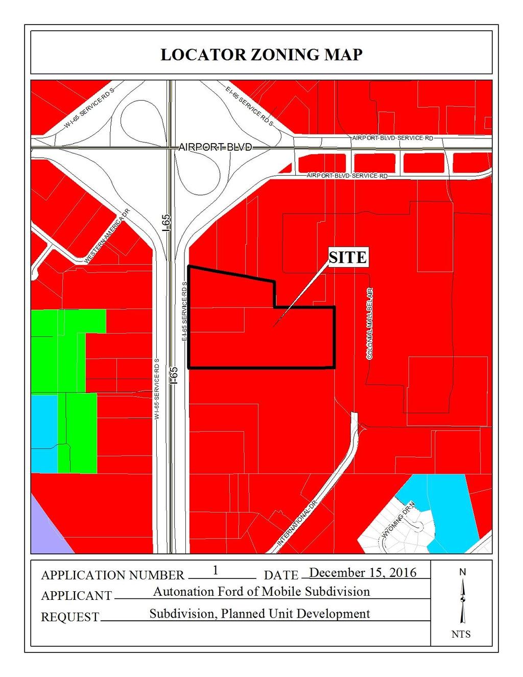
1 PLANNED UNIT DEVELOPMENT & SUBDIVISION STAFF REPORT Date: November 17, 2016 DEVELOPMENT NAME SUBDIVISION NAME LOCATION Autonation Ford of Mobile Autonation Ford of Mobile Subdivision 901, 909, and 925 East I-65 Service Road South (East side of East I-65 Service Road South, 3/10 mile± North of International Drive). CITY COUNCIL DISTRICT District 5 AREA OF PROPERTY CONTEMPLATED USE TIME SCHEDULE FOR DEVELOPMENT 3 Lots / 17.8 ± acres, Subdivision 2 Lots / 7.8 ± acres, Planned Unit Development Planned Unit Development Approval to amend a previously approved Planned Unit Development to allow multiple buildings on a single building site along with shared access between multiple building sites; and Subdivision approval to create three legal lots of record. Not specified ENGINEERING COMMENTS Subdivision: FINAL PLAT COMMENTS (should be addressed prior to submitting the FINAL PLAT for acceptance and signature by the City Engineer): A. Provide all of the required information on the SUBDIVISION PLAT (i.e. signature blocks, signatures, certification statements, written legal description, required notes, legend, scale, bearings and distances) that is required by the current Alabama State Board of Licensure for Professional Engineers and Land Surveyors. B. Revise the plat to label each lot with its size in acres and square feet, or the furnishing of a table on the Plat providing the same information. C. Provide a written legal description for the proposed subdivision (boundary) and matching bearing and distance labels. D. Show and label each and every Right-Of-Way and easement, especially the drainage easements. E. Provide and label the monument set or found at each subdivision corner. F. Provide the Surveyor s, Owner s (notarized), Planning Commission, and Traffic Engineering signatures.
2 G. The area along the east property line is receiving drainage from a public street and will require a PUBLIC (Dedicated to the City of Mobile) drainage easement; the width and alignment of the easement shall be coordinated with, and approved by, the City Engineer. H. Add a note to the SUBDIVISION PLAT stating that a Land Disturbance permit will be required for any land disturbing activity in accordance with Mobile City Code, Chapter 17, Storm Water Management and Flood Control); the City of Mobile, Alabama Flood Plain Management Plan (1984); and, the Rules For Erosion and Sedimentation Control and Storm Water Runoff Control. I. Add a note to the Plat stating that the approval of all applicable federal, state, and local agencies (including all storm water runoff, wetland and floodplain requirements) will be required prior to the issuance of a Land Disturbance permit. J. Add a note that sidewalk is required to be constructed, and/or repaired, along the frontage of each lot, or parcel, at time of new development or construction, unless a sidewalk waiver is approved. K. Remove the County Engineer s signature block from the Plat. The County Engineer no longer signs plats within the municipal limits of the City of Mobile. L. Provide a copy of the FINAL PLAT to the Engineering Dept. for FINAL PLAT review prior to obtaining any signatures. M. After FINAL PLAT review by the Engineering Dept. provide the red-line markup, a copy of the revised original Final Plat, and the original when submitting for City Engineer signature. Planned Unit Development: PUD Site Plan was not labeled. included, one with and one without the parking lot to the south. Two different plans were ADD THE FOLLOWING NOTES TO THE PUD SITE PLAN: 1. Any work performed in the existing ROW (right-of-way) such as driveways, sidewalks, utility connections, grading, drainage, irrigation, or landscaping will require a ROW permit from the City of Mobile Engineering Department ( ) and must comply with the City of Mobile Right-of-Way Construction and Administration Ordinance (Mobile City Code, Chapter 57, Article VIII). An ALDOT permit will also be required. 2. A Land Disturbance Permit application shall be submitted for any proposed land disturbing activity with the property. A complete set of construction plans including, but not limited to, drainage, utilities, grading, storm water detention systems, paving, and all above ground structures, will need to be included with the Land Disturbance permit. This Permit must be submitted, approved, and issued prior to beginning any of the construction work. 3. Any and all proposed land disturbing activity within the property will need to be submitted for review and be in conformance with Mobile City Code, Chapter 17, Storm Water Management and Flood Control); the City of Mobile, Alabama Flood Plain Management Plan (1984); and, the Rules For Erosion and Sedimentation Control and Storm Water Runoff Control. 4. The approval of all applicable federal, state, and local agencies (including all storm water runoff, wetland and floodplain requirements) will be required prior to the issuance of a Land Disturbance permit. The Owner/Developer is responsible for acquiring all of the necessary permits and approvals. 5. The proposed development must comply with all Engineering Department design requirements and Policy Letters
3 TRAFFIC ENGINEERING COMMENTS East I-65 Service Road South is an ALDOT maintained roadway. Driveway number, size, location and design to be approved by ALDOT and Traffic Engineering and conform to AASHTO standards. New required on-site parking, including ADA handicap spaces, shall meet the minimum standards as defined in Section 64-6 of the City s Zoning Ordinance. URBAN FORESTRY COMMENTS Property to be developed in compliance with state and local laws that pertain to tree preservation and protection on both city and private properties (State Act and City Code Chapters 57 and 64). FIRE DEPARTMENT COMMENTS All projects within the City Limits of Mobile shall comply with the requirements of the City of Mobile Fire Code Ordinance (2012 International Fire Code). MAWSS COMMENTS MAWSS has water and sewer services available, but a Capacity Assurance application for additional sewer service has not been applied for. MAWSS cannot guarantee additional sewer service until a Capacity application is approved by Volkert Engineering, Inc. REMARKS The applicant is seeking Planned Unit Development Approval to amend a previously approved Planned Unit Development to allow multiple buildings on a single building site along with shared access between multiple building sites, and Subdivision approval to create three (3) legal lots of record. The site is located in Council District 5, and is served by public water and sanitary sewer. The site was originally the subject of Subdivision and Planned Unit Development (PUD) approvals at the March 18, 2004 meeting of the Planning Commission to create three legal lots, and to allow multiple buildings on a single building site and shared access between multiple lots. The largest portion of the site south of the Autonation Ford of Mobile development was originally the subject of Subdivision approval for two lots at the May 15, 2008 meeting of the Planning Commission, and again at its March 7, 2013 meeting to re-subdivide Lot 1. Both the Subdivision and Planned Unit Development for Autonation Ford of Mobile were granted 1-year extensions at the March 17, 2005, March 16, 2006 and March 15, 2007 meetings of the Planning Commission before expiring in 2008; and the Subdivisions for the largest portion of the site south of the Autonation Ford of Mobile development were recorded in Mobile County Probate Court. Most recently, in June, 2016, Autonation Ford of Mobile attempted to obtain a building permit for changes to the interior and exterior of their building that would result in changes to existing site improvements, specifically parking, not previously approved by the Planning Commission. Such changes also necessitate the site be a legal lot of record. Additionally, it appears Autonation Ford of Mobile is sharing access and parking with the metes-and-bounds parcel directly to the south of the site, as well with a portion of a larger legal lot whose address is 925 East I
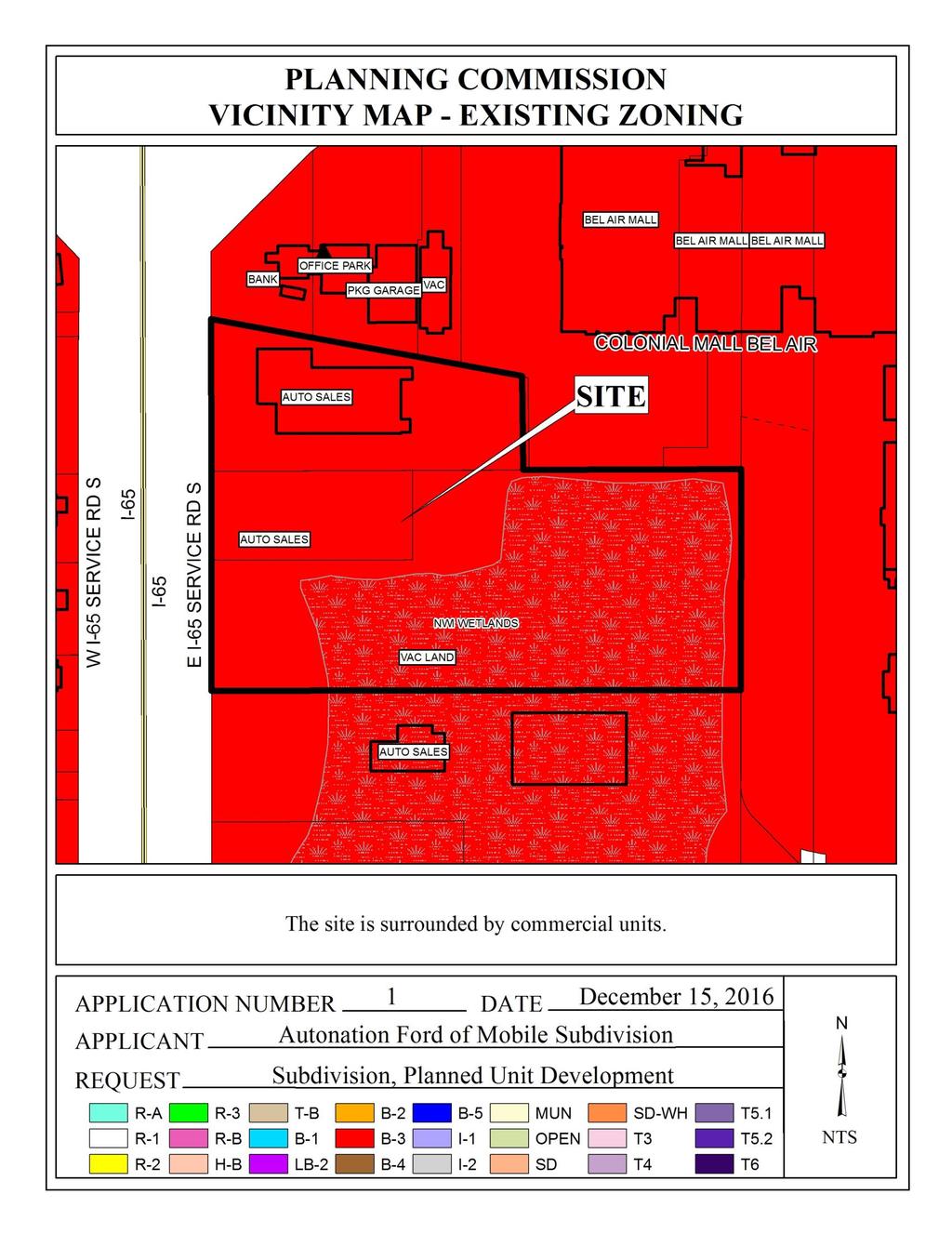
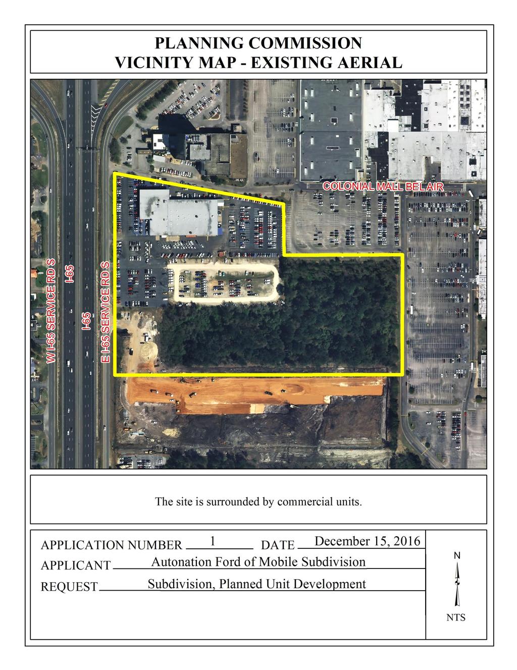
4 Service Road South; and, as such, will also require Subdivision and PUD approvals to accommodate: 1) that the lots are developed without approvals, or are to be developed; 2) that lease parcels in the State of Alabama are required to be legal lots of record; and 3) access is shared between the parcels. It should be noted that the parcel fully utilized to the south of the site was paved with asphalt between 2006 and 2010 without a Land Disturbance permit. The site is zoned B-3, Community Business District, thus the auto sales and service are allowed by right. Planned Unit Development review examines the site with regard to its location to ensure that it is generally compatible with neighboring uses; that adequate access is provided without generating excess traffic along minor residential streets in residential districts outside the PUD; and that natural features of the site are taken into consideration. PUD review also examines the design of the development to provide for adequate circulation within the development; to ensure adequate access for emergency vehicles; and to consider and provide for protection from adverse effects of adjacent properties as well as provide protection of adjacent properties from adverse effects from the PUD. PUD approval is site-plan specific, thus any changes to the site plan / Subdivision plat will require approval by the Planning Commission. Subdivision review examines the site with regard to promoting orderly development, protecting general health, safety and welfare, and ensuring that development is correlated with adjacent developments and public utilities and services, and to ensure that the subdivision meets the minimum standards set forth in the Subdivision Regulations for lot size, road frontage, lot configuration, etc. It should be noted that the site is located within what the Map for Mobile Comprehensive Plan describes as a Suburban Center Development Area, wherein the intent for development includes: greater density including mixed-use with residential above community scale services and retail; accommodation of all users: automobile, bicycle, pedestrian, and transit; connectivity to surrounding neighborhoods through sidewalks, trails, etc.; encourage redevelopment of existing strip centers into mixed-use development or green space; and emphasis on adding density, mixing uses and promoting walkability and connectivity to other areas of the City. The preliminary plat illustrates the two proposed parcels directly to the South of Autonation Ford of Mobile, but not the parcel on which Autonation Ford of Mobile is developed. Considering the applicant wishes to have shared access between these three lots, the plat should be revised to include the lot on which Autonation Ford of Mobile is located. Also, it should be noted that there is some ambiguity with regards to how the lots should be identified (e.g. Lot 1, Lot 2, etc.). As such, the lots should be appropriately labeled on a revised plat to facilitate their identification. The site has frontage on East I-65 Service Road South, to the West, which services U.S. Interstate Highway 65, a limited access route with a 300 right-of-way width. The preliminary plat does not illustrate or indicate dedication sufficient to provide 150 from the centerline of - 4 -
5 U.S. Interstate Highway 65; and, as such, the plat should be revised to either provide sufficient right-of-way dedication, or illustrate that the existing right-of-way is sufficient. It should be noted that the site also fronts Joe Treadwell Drive, a private access road, to the north. The larger of the proposed lots is a flag lot with a pole providing frontage onto East I-65 Service Road South in width and more than 1,100 ± long. Flag lots are generally discouraged by Section V.D.1. of the Subdivision Regulations; however, they are permitted in those locations where varied and irregularly-shaped lot designs are common, and the informality of design is consistent with other lots in the vicinity. Because there are several flag-shaped lots in this area, including the subject site that was approved by the Planning Commission at its March 7, 2013 meeting, a waiver of Section V.D.1. may be appropriate. The sizes of the proposed lots are provided in square feet and acres; however, the width of the pole of the proposed flag lot is large enough to be potentially re-subdivided and, in accordance with the Subdivision Regulations, is not exclusive of unusable land, thus contributing to a maximum depth more than 3.5 times the width of the lot at the potential building setback line; and, as such, a waiver of Section V.D.3. will be required for approval. Additionally, it should be noted that the width of the pole of the proposed flag lot would allow for the construction of a public or private road in the future. Irrespective of the width-to-depth ratio, the proposed lots exceed the minimum size requirements of the Subdivision Regulations and, as is mentioned, are appropriately labeled. This information should be retained on the revised and final plats. With regards to access management, the smaller of the two illustrated lots should be limited to one curb cut, and the larger of the two illustrated lots should be limited to two curb cuts, with any changes in their sizes, locations and designs to be approved by Traffic Engineering and conform to AASHTO standards. This information will need to be iterated in a note on the Final Plat, if approved. The preliminary plat does not indicate a 25 building setback line for either proposed lot, which is a requirement of Section V.D.9. of the Subdivision Regulations. As such, this information should be illustrated on the revised plat, adjusted for any right-of-way dedication. Regarding the PUD request, the applicant proposes to extend development of the Autonation Ford of Mobile site to the smaller of the two illustrated lots to increase the storage capacity of new vehicle inventory. There are 450 parking spaces illustrated on the aforementioned lot, and are reserved for vehicle inventory according to a table illustrated on the site plan. A portion of the proposed inventory area shows parking spaces stacked for four vehicles with no access aisles between them. Such configuration of vehicle inventory is common, but these spaces should be clearly indicated on the site plan as being reserved exclusively for inventory and not for customer parking. Furthermore, the area proposed for inventory storage is depicted as being completely enclosed with a chain-link fence with no access aisles. If approved, the site plan should be revised to indicate a gate and access aisles
6 With regards to the existing Autonation Ford of Mobile development, a separate site plan illustrates the existing site improvements, to include: a 48,010 s.f. building; an approximately 551 s.f. shed; 415 delineated parking spaces; and existing signage. Proposed site improvements include: the addition of an approximately 1,134 s.f. wash bay to the rear of the existing building; new concrete paving, where required; new asphalt paving to facilitate water drainage from the proposed wash bay; a new gate and fence to restrict access to the site along its easternmost, existing curb cut; and additional signage. While parking is illustrated on the site plan, it is unclear which spaces are reserved for the parking of inventory; therefore, Staff cannot determine if the site is equipped with adequate amounts of off-street parking for customers and employees of the development. As a result, Staff also cannot determine compliance with parking lot lighting, parking stall requirements regarding stall dimensions, or if curbing or wheel stops are provided where customer and employee vehicles may extend beyond the parking facility; and, Staff cannot determine compliance with ADA regulations regarding required amounts of accessible parking spaces and their required dimensions. As such, the site plan should be revised to clarify this information and illustrate compliance with off-street parking requirements of Section 64-6.A. of the Zoning Ordinance. Regarding existing and proposed structures, while they will not impact the site with respect to maximum building site coverage in a B-3, Community Business District, their dimensions should be clearly illustrated on a revised site plan. The proposed wash bay in the rear of the property does not appear to meet setback requirements of the Zoning Ordinance regarding structures in a B-3 district subject to previous PUD approval, or screening or drainage requirements of the Zoning Ordinance regarding car wash facilities. The proposed structure must be either 0 or 5 from the property line, but is illustrated as being approximately 3 from the property line. It should be noted, however, that a proposed island facilitating an existing curb cut will prohibit the structure from being constructed to the property line; and, while the structure could be reduced in width by approximately 2 to accommodate a 5 setback, approval of the proposed setback may be appropriate since it would effectively facilitate maneuverability from the rear of the site to the front of the site by restricting one-way traffic circulation at a location not adequate for two-way traffic due to the proposed island. Also, while the proposed structure is enclosed on at least two sides, vehicles must be screened from view with a 3-5 tall evergreen hedge, landscaped berm, or privacy fence along the side(s) of the property from which the wash bay will be visible; and, all water run-off from washing activity must drain into the proper sewer system through an oil separator. Revision of the site plan to illustrate compliance with Section of the Zoning Ordinance regarding car wash facilities should be required. It should be noted that it is unclear if all existing and proposed fencing on the site does, or will, comply with the Zoning Ordinance. Also, in a pre-development meeting with Staff, the applicant expressed a desire to erect barbed-wire fencing on the site; however, no such fencing is illustrated. A revised site plan should indicate that existing and proposed fencing complies with Section 64-4.D.6. of the Zoning Ordinance; and, if any fences composed of barbed wired are proposed, that they comply with Section 64-4.D.6.b., specifically, of the Zoning Ordinance
7 Signage proposed on the site plan for Autonation Ford of Mobile appears to exceed maximum allowable signage requirements of the Zoning Ordinance. While the Planning Commission may consider such additional signage with respect to the PUD, Staff has not been provided specific information regarding the signs themselves to illustrate compliance with sign dimension and location requirements; and, as such, should be illustrated in a sign package that will facilitate the review of such information. Landscaping is not proposed on the site plan, but since the total gross floor area of existing and proposed structures on the site is neither increasing nor decreasing by fifty (50) percent, full compliance with landscaping is not required at this time. However, it should be noted that the Planning Commission typically requests frontage trees for Planned Unit Developments, which should be illustrated on a revised site plan along with any existing trees and landscaping, in compliance with Section 64-4.E.3. of the Zoning Ordinance. A dumpster is not depicted on the site plan and one is not clearly visible in recent aerial photos. Any dumpster placed on the property must be in compliance with the current enclosure and sanitary sewer connection requirements of Section 64-4.D.9. of the Zoning Ordinance and must be illustrated on a revised site plan(s); or, placement of a note on the revised site plan stating that curbside pickup will be utilized will be acceptable. It should be noted that separate site plans were submitted to Staff for review, neither of which illustrate the entire development across the existing site and the two proposed lots to which the applicant proposes shared access. As such, and in considering PUD review is site-plan specific and takes into consideration the entire development, proposed or otherwise, the applicant should submit a revised site plan inclusive of all three lots. Finally, in considering the preceding with regards to Map for Mobile Comprehensive Plan, while the plan emphasizes adding denser, mixed-use developments with respect to re-developments similar to the subject site, doing so to an existing auto dealership may not be appropriate at this time. However, should the site ever be converted to non-auto centric uses, reconsideration may be appropriate. RECOMMENDATION Subdivision: Based upon the preceding this application is recommended for Holdover to the December 15, 2016 meeting, with revisions submitted by December 1, 2016, to allow the applicant to address the following: 1) submit a revised preliminary plat to include all three lots with which the development will have shared access. Planned Unit Development: Based upon the preceding this application is recommended for Holdover to the December 15, 2016 meeting, with revisions submitted by December 1, 2016, to allow the applicant to address the following: - 7 -
8 1) submit a full site plan illustrating all existing and proposed site improvements to the entire Planned Unit Development. Revised for the December 15 th meeting: The application was heldover to allow the applicant to submit a revised preliminary plat showing all three lots associated with the Autonation Ford development, as well as to submit a revised site plan illustrating all existing and proposed site improvements to the entire Planned Unit Development. The revised preliminary plat illustrates three lots, including Lots A and B whereon Autonation Ford is developed. The proposed lots exceed the minimum size requirements of the Subdivision Regulations and are appropriately labeled in square feet and acres. This information should be retained on the Final Plat, or a table providing the same information should be furnished on the Final Plat, if approved. The plat illustrates that the existing right-of-way for Interstate Highway 65 is sufficient; therefore, no additional dedication should be required. With regards to access management, Proposed Lots A and B should be limited to the existing three curb cuts, with any changes in their sizes, locations, or designs to be approved by ALDOT and Traffic Engineering, and conform to AASHTO standards. The 25 minimum building setback line is illustrated along East I-65 Service Road and should be retained on the Final Plat, if approved. A 40 drainage easement is illustrated on the North of Lots B and C. Additional 30 and 40 drainage easements are illustrated in the East and South of Lot C, respectively, as well as a 20 water line easement, also in the East of Lot C, and a 3,200± s.f. sign easement along a portion of the street frontage of Lot C. As such, with the exception of the aforementioned sign easement, a note should be placed on the Final Plat and PUD site plan stating no structures may be built in any easement. The revised PUD site plan illustrates the proposed expansion of Autonation Ford on Lots A and B. A table on the site plan indicates a total of 765 parking spaces, 20 of which are reserved in front of the building for customers and the remaining spaces to be used to store vehicle inventory. Curbing is shown where customer spaces are reserved, and each parking stall meets minimum dimension requirements regarding stall length and width. It should be noted, however, that Staff is still unable to determine if proposed customer parking will satisfy minimum off-street parking requirements of the Zoning Ordinance. A revised site plan should indicate compliance with such requirements by providing one (1) parking space per 300 s.f. of gross floor area devoted to office or commercial use, plus one (1) parking space per 3 employees in the automotive repair portion of the business
9 It should be noted that, while the Zoning Ordinance does not enforce ADA compliance regarding accessible parking, one (1) accessible space is illustrated on the site plan and does not appear to meet minimum access aisle dimension requirements. Revision to the site plan should illustrate an ADA-compliant accessible parking space. An existing gate and proposed access aisle are illustrated as providing access to proposed inventory parking on Lot B from Lot A, and the site plan also indicates which existing and proposed parking spaces will be reserved for automobile inventory. Given the additional parking spaces will not be utilized by customers or employees, and customer parking area is not being increased, a photometric plan will not be required; however, any new lighting on the site is subject to the appropriate lighting requirements iterated in Sections 64-4.A.2. and 64-6.A.3.c. of the Zoning Ordinance, including lighting for inventory. The dimensions of existing and proposed structures on the site are illustrated and should be retained on a final site plan, if approved. Revisions to the site plan regarding the proposed wash bay illustrates the structure will abut the proposed island at the property line; however, compliance with Section of the Zoning Ordinance regarding car wash facilities is not illustrated. Vehicles in the wash bay must be screened from view with a 3-5 tall evergreen hedge, landscaped berm, or privacy fence along the side(s) of the property from which the wash bay will be visible; and, all water run-off from washing activity must drain into the sanitary sewer system through an oil separator. This information should be illustrated on a revised site plan, if approved. A note on the site plan indicates the site will comply with Section 64-4.D.6. of the Zoning Ordinance regarding fencing, including a new chain link fence segment along Joe Treadwell Drive. It should be noted that barbed wire fencing is not illustrated on the site plan; therefore, the addition of such fencing should be subject to the approval of the Director of the Planning and Zoning Department, or his/her designee. Regarding signage, the site was the subject of Sign Variance approval at the March 2, 1998 meeting of the Board of Zoning Adjustment to allow four freestanding signs and three wall signs on a single-tenant site, subject to full compliance with the landscaping and tree planting requirements of the Zoning Ordinance. Three existing freestanding signs are illustrated on the site plan, as well as three new wall signs that are proposed to replace existing wall signage. Staff was not provided information regarding the proposed signs; however, the applicant should be aware that changes to existing wall signs may be subject to approval of a new Sign Variance by the Board of Zoning Adjustment. Also, while not a specific requirement of the PUD request at hand, it should be noted that the site does not comply with the condition of approval of the Sign Variance to provide the appropriate trees and landscaping; and, no trees or landscaping information is provided on the site plan. As such, revision of the site plan to illustrate full compliance with tree and landscaping requirements of the Zoning Ordinance should be required unless the applicant wishes to amend such a condition of approval in an additional variance request to the Board of Zoning Adjustment
10 A new dumpster pad with enclosure is illustrated on the site plan and should comply with Section 64-4.D.9. of the Zoning Ordinance regarding enclosure and sanitary sewer requirements. A note stating as much should be provided on a revised site plan, if approved. Finally, it should be noted that Planned Unit Development approval is only good for one year. If the request is approved and no permits are obtained within one year to initiate land disturbance or new construction, as proposed, the PUD approval will expire. RECOMMENDATION Subdivision: Based on the preceding, with a waiver of Sections V.D.1. and V.D.3. of the Subdivision Regulations, this application is recommended for Tentative Approval, subject to the following conditions: 1) retention of the lot sizes in both square feet and acres on the Final Plat, or furnishing of a table on the Final Plat providing the same information; 2) placement of a note on the Final Plat stating Lots A and B are limited to their existing curb cuts, and Lot C is limited to two curb cuts, with any changes in their sizes, locations, or designs to be approved by ALDOT and Traffic Engineering, and conform to AASHTO standards; 3) retention of the 25 minimum building setback line along East I-65 Service Road South; 4) placement of a note on the Final Plat stating no structures may be built in any easement, with the exception of the sign easement; 5) compliance with Engineering Comments: (FINAL PLAT COMMENTS (should be addressed prior to submitting the FINAL PLAT for acceptance and signature by the City Engineer): A) Provide all of the required information on the SUBDIVISION PLAT (i.e. signature blocks, signatures, certification statements, written legal description, required notes, legend, scale, bearings and distances) that is required by the current Alabama State Board of Licensure for Professional Engineers and Land Surveyors. B) Revise the plat to label each lot with its size in acres and square feet, or the furnishing of a table on the Plat providing the same information. C) Provide a written legal description for the proposed subdivision (boundary) and matching bearing and distance labels. D) Show and label each and every Right-Of-Way and easement, especially the drainage easements. E) Provide and label the monument set or found at each subdivision corner. F) Provide the Surveyor s, Owner s (notarized), Planning Commission, and Traffic Engineering signatures. G) The area along the east property line is receiving drainage from a public street and will require a PUBLIC (Dedicated to the City of Mobile) drainage easement; the width and alignment of the easement shall be coordinated with, and approved by, the City Engineer. H) Add a note to the SUBDIVISION PLAT stating that a Land Disturbance permit will be required for any land disturbing activity in accordance with Mobile City Code, Chapter 17, Storm Water Management and Flood Control); the City of Mobile, Alabama Flood Plain Management Plan (1984); and, the Rules For Erosion and Sedimentation Control and Storm Water Runoff Control. I) Add a note to the Plat stating that the approval of all applicable federal, state, and local agencies (including all storm water runoff, wetland and floodplain requirements) will be required prior to the issuance of a Land Disturbance permit. J) Add a note that sidewalk is required to be constructed, and/or repaired, along
11 the frontage of each lot, or parcel, at time of new development or construction, unless a sidewalk waiver is approved. K) Remove the County Engineer s signature block from the Plat. The County Engineer no longer signs plats within the municipal limits of the City of Mobile. L) Provide a copy of the FINAL PLAT to the Engineering Dept. for FINAL PLAT review prior to obtaining any signatures. M) After FINAL PLAT review by the Engineering Dept. provide the red-line markup, a copy of the revised original Final Plat, and the original when submitting for City Engineer signature.); 6) compliance with Traffic Engineering Comments: (East I-65 Service Road South is an ALDOT maintained roadway. Driveway number, size, location and design to be approved by ALDOT and Traffic Engineering and conform to AASHTO standards. New required on-site parking, including ADA handicap spaces, shall meet the minimum standards as defined in Section 64-6 of the City s Zoning Ordinance.); 7) compliance with Urban Forestry Comments: (Property to be developed in compliance with state and local laws that pertain to tree preservation and protection on both city and private properties (State Act and City Code Chapters 57 and 64).); 8) compliance with Fire Department comments: (All projects within the City Limits of Mobile shall comply with the requirements of the City of Mobile Fire Code Ordinance (2012 International Fire Code).); 9) revision of the PUD site plan prior to signing of the Final Plat; 10) completion of the subdivision process prior to any requests for new construction; and 11) compliance with all applicable codes and ordinances. Planned Unit Development: Based on the preceding, the application is recommended for Approval, subject to the following conditions: 1) revision of the site plan to illustrate lot sizes in both square feet and acres, or furnishing of a table on the site plan providing the same information; 2) placement of a note on the site plan stating Lots A and B are limited to their existing curb cuts, with any changes in their sizes, locations, or designs to be approved by ALDOT and Traffic Engineering, and conform to AASHTO standards; 3) revision of the site plan to illustrate the 25 minimum building setback line along East I- 65 Service Road South; 4) placement of a note on the site plan stating no structures may be built in any easement; 5) revision of the site plan to illustrate compliance with Section 64-6.A.6. of the Zoning Ordinance regarding the appropriate amounts of off-street parking spaces for officedistribution mixed use establishments; 6) placement of a note on the site plan stating any new lighting on the site must comply with Sections 64-4.A.2. and 64-6.A.3.c. of the Zoning Ordinance; 7) retention of the sizes of proposed and existing structures; 8) revision of the site plan to illustrate compliance with Section of the Zoning Ordinance regarding car washes; 9) retention of the note stating fencing on the site will comply with Section 64-4.D.6. of the Zoning Ordinance;
12 10) placement of a note on the site plan stating the addition of barbed wire fencing on the site is subject to the approval of the Director of the Planning and Zoning Department, or his/her designee; 11) revision of the site plan to illustrate full compliance with Section 64-4.E.3. of the Zoning Ordinance regarding trees and landscaping, or approval of Tree and Landscaping Variances by the Board of Zoning Adjustment; 12) placement of a note on the site plan stating the existing dumpster will comply with Section 64-4.D.9. of the Zoning Ordinance regarding enclosure and sanitary sewer requirements; 13) compliance with Engineering Comments: (ADD THE FOLLOWING NOTES TO THE PUD SITE PLAN: 1) Any work performed in the existing ROW (right-of-way) such as driveways, sidewalks, utility connections, grading, drainage, irrigation, or landscaping will require a ROW permit from the City of Mobile Engineering Department ( ) and must comply with the City of Mobile Right-of-Way Construction and Administration Ordinance (Mobile City Code, Chapter 57, Article VIII). An ALDOT permit will also be required. 2) A Land Disturbance Permit application shall be submitted for any proposed land disturbing activity with the property. A complete set of construction plans including, but not limited to, drainage, utilities, grading, storm water detention systems, paving, and all above ground structures, will need to be included with the Land Disturbance permit. This Permit must be submitted, approved, and issued prior to beginning any of the construction work. 3) Any and all proposed land disturbing activity within the property will need to be submitted for review and be in conformance with Mobile City Code, Chapter 17, Storm Water Management and Flood Control); the City of Mobile, Alabama Flood Plain Management Plan (1984); and, the Rules For Erosion and Sedimentation Control and Storm Water Runoff Control. 4) The approval of all applicable federal, state, and local agencies (including all storm water runoff, wetland and floodplain requirements) will be required prior to the issuance of a Land Disturbance permit. The Owner/Developer is responsible for acquiring all of the necessary permits and approvals. 5) The proposed development must comply with all Engineering Department design requirements and Policy Letters.); 14) compliance with Traffic Engineering Comments: (East I-65 Service Road South is an ALDOT maintained roadway. Driveway number, size, location and design to be approved by ALDOT and Traffic Engineering and conform to AASHTO standards. New required on-site parking, including ADA handicap spaces, shall meet the minimum standards as defined in Section 64-6 of the City s Zoning Ordinance.); 15) compliance with Urban Forestry Comments: (Property to be developed in compliance with state and local laws that pertain to tree preservation and protection on both city and private properties (State Act and City Code Chapters 57 and 64).); 16) compliance with Fire Department comments: (All projects within the City Limits of Mobile shall comply with the requirements of the City of Mobile Fire Code Ordinance (2012 International Fire Code).); 17) submission of two revised PUD site plans to the Planning and Zoning Department prior to the signing of the Final Plat; 18) completion of the subdivision process prior to any requests for new construction; and 19) compliance with all applicable codes and ordinances
13 - 13 -
14 - 14 -
15 - 15 -
16 - 16 -
17 - 17 -
18 - 18 -
PLANNED UNIT DEVELOPMENT & SUBDIVISION STAFF REPORT August 18, 2016
 PLANNED UNIT DEVELOPMENT & SUBDIVISION STAFF REPORT August 18, 2016 DEVELOPMENT NAME SUBDIVISION NAME Mullinax Ford Subdivision Mullinax Ford Subdivision LOCATION CITY COUNCIL DISTRICT District 6 Southeast
ZONING AMENDMENT & SUBDIVISION STAFF REPORT Date: November 3, 2016
 ZONING AMENDMENT & SUBDIVISION STAFF REPORT Date: November 3, 2016 APPLICANT NAME SUBDIVISION NAME David Shumer 5955 Airport Subdivision CITY COUNCIL DISTRICT District 6 5955 Airport Boulevard, 754 Linlen
PLANNED UNIT DEVELOPMENT & SUBDIVISION STAFF REPORT Date: July 20, 2017
 PLANNED UNIT DEVELOPMENT & SUBDIVISION STAFF REPORT Date: July 20, 2017 DEVELOPMENT NAME SUBDIVISION NAME LOCATION Rangeline Crossing III Subdivision Rangeline Crossing III Subdivision 5289 Halls Mill
ZONING AMENDMENT, PLANNED UNIT DEVELOPMENT & SUBDIVISION STAFF REPORT Date: August 8, 2013
 ZONING AMENDMENT, PLANNED UNIT DEVELOPMENT & SUBDIVISION STAFF REPORT Date: August 8, 2013 NAME SUBDIVISION NAME PV-Magnolia, LLC Twelve Trees Subdivision LOCATION 2860, 2862 and 2866 Pleasant Valley Road
PLANNED UNIT DEVELOPMENT & SUBDIVISION STAFF REPORT Date: September 15, 2016
 # 10 SUB2016-00089 PLANNED UNIT DEVELOPMENT & SUBDIVISION STAFF REPORT Date: September 15, 2016 NAME SUBDIVISION NAME LOCATION Lot 12 Laughlin Industrial Park Subdivision Lot 12 Laughlin Industrial Park
DAUPHIN CREEK ESTATES SUBDIVISION
 # 12 SUB-000076-2017 DAUPHIN CREEK ESTATES SUBDIVISION Engineering Comments: FINAL PLAT COMMENTS (should be addressed prior to submitting the FINAL PLAT for review and/or signature by the City Engineer):
ZONING AMENDMENT & SUBDIVISION STAFF REPORT Date: July 9, 2015
 ZONING AMENDMENT & SUBDIVISION STAFF REPORT Date: July 9, 2015 APPLICANT NAME 2513 Dauphin Street, Inc. SUBDIVISION NAME Audubon Place Extension No. 3, Resubdivision of Lots 1-5 LOCATION 2513 Dauphin Street
ALBA BEACH SUBDIVISION, RESUBDIVISION OF LOT 17
 ALBA BEACH SUBDIVISION, RESUBDIVISION OF LOT 17 Engineering Comments: FINAL PLAT COMMENTS (should be addressed prior to submitting the FINAL PLAT for acceptance and signature by the City Engineer): A.
SUBDIVISION, PLANNED UNIT DEVELOPMENT, ZONING AMENDMENT, & SIDEWALK WAIVER STAFF REPORT Date: July 19, 2018
 SUBDIVISION, PLANNED UNIT DEVELOPMENT, ZONING AMENDMENT, & SIDEWALK WAIVER STAFF REPORT Date: July 19, 2018 NAME SUBDIVISION NAME LOCATION West Mobile Properties, LLC U.S. Machine Subdivision 556, 566,
PLANNED UNIT DEVELOPMENT & SUBDIVISION STAFF REPORT Date: April 18, 2019
 PLANNED UNIT DEVELOPMENT & SUBDIVISION STAFF REPORT Date: April 18, 2019 DEVELOPMENT NAME SUBDIVISION NAME Springhill Village Subdivision Springhill Village Subdivision LOCATION 4350, 4354, 4356, 4358,
SUBDIVISION & PLANNING APPROVAL STAFF REPORT Date: December 1, 2016
 SUBDIVISION & PLANNING APPROVAL STAFF REPORT Date: December 1, 2016 APPLICANT NAME SUBDIVISION NAME DEVELOPMENT NAME LOCATION Board of Water and Sewer Commissioners of the City of Mobile Halls Mill Road
BROADWAY THREE NOTCH ROAD SUBDIVISION
 # 3 SUB-000803-2018 BROADWAY THREE NOTCH ROAD SUBDIVISION Engineering Comments: FINAL PLAT COMMENTS (should be addressed prior to submitting the FINAL PLAT for review and/or signature by the City Engineer):
PLANNED UNIT DEVELOPMENT STAFF REPORT Date: October 19, 2017
 PLANNED UNIT DEVELOPMENT STAFF REPORT Date: October 19, 2017 DEVELOPMENT NAME LOCATION Custom Boat Storage 3975 Demetropolis Road (East side of Demetropolis Road, 0.2± miles South of Halls Mill Road.)
JOHNNY S RV PARK SUBDIVISION
 # 11 SUB2016-00001 JOHNNY S RV PARK SUBDIVISION Engineering Comments: The following comments should be addressed prior to submitting the FINAL PLAT for acceptance and signature by the City Engineer: A.
SUBDIVISION, PLANNED UNIT DEVELOPMENT, & REZONING STAFF REPORT Date: September 17, 2015
 SUBDIVISION, PLANNED UNIT DEVELOPMENT, & REZONING STAFF REPORT Date: September 17, 2015 APPLICANT NAME SUBDIVISION NAME DEVELOPMENT NAME LOCATION Daniel Clark Mack Manufacturing Subdivision, Resubdivision
THE CI FY OF MOBILE, ALABAMA
 THE CI FY OF MOBILE, ALABAMA LETTER OF DECISION DewberryiPreble-Rish 9949 Bellaton Avenue Daphne, AL 36526 Re: Area bounded by Foxtail Drive, Lace Bark Drive and Whitebark Drive Council District 6 SUB-000323-2017
McGowin Park, LLC. B-3, Community Business District
 # 10, 11, 12 SUB2014-00024 ZON2014-00500 ZON2014-00501 SUBDIVISION, PLANNED UNIT DEVELOPMENT (East), PLANNED UNIT DEVELOPMENT (West) STAFF REPORT Date: April 3, 2014 DEVELOPMENT NAME LOCATION McGowin Park,
MOBILE TOWERS SUBDIVISION
 # 3 SUB2014-00100 MOBILE TOWERS SUBDIVISION Engineering Comments: The following comments should be addressed prior to submitting the FINAL PLAT for acceptance and signature by the City Engineer: 1) Provide
THE WHEELER BUILDING SUBDIVISION
 THE WHEELER BUILDING SUBDIVISION Engineering Comments: FINAL PLAT COMMENTS (should be addressed prior to submitting the FINAL PLAT for review and/or signature by the City Engineer): A. Provide all of the
ZONING AMENDMENT & SUBDIVISION STAFF REPORT Date: June 18, 2015
 ZONING AMENDMENT & SUBDIVISION STAFF REPORT Date: June 18, 2015 APPLICANT NAME SUBDIVISION NAME EAA LLC / Eryka Rogers Aaiden Place Subdivision LOCATION 2480 Government Boulevard (North side of Government
TULSA PARK ESTATES SUBDIVISION, RESUBDIVISION OF LOT 6
 TULSA PARK ESTATES SUBDIVISION, RESUBDIVISION OF LOT 6 Engineering Comments: FINAL PLAT COMMENTS (should be addressed prior to submitting the FINAL PLAT for review and/or signature by the City Engineer):
WESTMINSTER PARK PLACE SUBDIVISION
 WESTMINSTER PARK PLACE SUBDIVISION Engineering Comments: FINAL PLAT COMMENTS (should be addressed prior to submitting the FINAL PLAT for review and/or signature by the City Engineer): A. Provide all of
SUBDIVISION, PLANNING APPROVAL, & REZONING STAFF REPORT Date: June 4, 2015
 SUBDIVISION, PLANNING APPROVAL, & REZONING STAFF REPORT Date: June 4, 2015 APPLICANT NAME SUBDIVISION NAME DEVELOPMENT NAME LOCATION Board of Water & Sewer Commissioners of the City of Mobile MAWSS MLK
PLANNED UNIT DEVELOPMENT & ZONING AMENDMENT STAFF REPORT Date: December 21, 2017
 # 14 PUD-000324-2017 & ZON-000326-2017 PLANNED UNIT DEVELOPMENT & ZONING AMENDMENT STAFF REPORT Date: December 21, 2017 APPLICANT NAME DEVELOPMENT NAME LOCATION Dewberry/Preble-Rish Longleaf Gates Subdivision,
ZONING AMENDMENT & SUBDIVISION STAFF REPORT Date: March 1, 2018
 #13 SUB-000406-2018 & ZON-000407-2018 ZONING AMENDMENT & SUBDIVISION STAFF REPORT Date: March 1, 2018 NAME SUBDIVISION NAME LOCATION Creekside @ Kooiman Dairy Creekside @ Kooiman Dairy Subdivision (South
PLANNED UNIT DEVELOPMENT & SUBDIVISION STAFF REPORT Date: March 15, 2007
 PLANNED UNIT DEVELOPMENT & SUBDIVISION STAFF REPORT Date: March 15, 2007 DEVELOPMENT NAME SUBDIVISION NAME LOCATION Motormax Subdivision Motormax Subdivision 2917 and 2929 Government Boulevard (South side
WESTMINSTER PARK SUBDIVISION
 WESTMINSTER PARK SUBDIVISION Engineering Comments: FINAL PLAT COMMENTS (should be addressed prior to submitting the FINAL PLAT for review and/or signature by the City Engineer): A. Provide all of the required
HAWTHORNE PLACE SUBDIVISON, RESUBDIVISION OF LOT 15 REVISED
 # 10 SUB-000336-2017 HAWTHORNE PLACE SUBDIVISON, RESUBDIVISION OF LOT 15 REVISED Engineering Comments: FINAL PLAT COMMENTS (should be addressed prior to submitting the FINAL PLAT for review and/or signature
THE CITY OF MOBILE, ALABAMA MOBILE Crry PLANNING COMMISSION
 THE CITY OF MOBILE, ALABAMA MOBILE Crry PLANNING COMMISSION LETTER OF DECISION MLK Avenue Redevelopment Corp. Attn: Michael Pierce P.O. Box 2204 Mobile, AL 36652 Re: Case #SUB2014-00040 (Subdivision) MLK
DINKINS ESTATE FAMILY SUBDIVISION
 # 9 SUB2015-00122 DINKINS ESTATE FAMILY SUBDIVISION Engineering Comments: The following comments should be addressed prior to submitting the FINAL PLAT for acceptance and signature by the City Engineer:
THE CITY OF MOBILE, ALABAMA
 THE CITY OF MOBILE, ALABAMA LETTER OF DECISION Dominion Senior Living of West Mobile, LLC 1200 Corporate Dr., St. 225 Birmingham, AL 35242 Re: 6924 Somerbv Lane (North terminus of Somerby Lane). Council
THE CITY OF MOBILE, ALABAMA
 THE CITY OF MOBILE, ALABAMA LE 'I IER OF DECISION Kimberly Clark Mobile Operations 200 Africatown Blvd. Prichard, AL 36610 Re: 100 & 200 Africatown Boulevard (Northeast corner of Bay Bridge Road and Paper
ZONING AMENDMENT, PLANNED UNIT DEVELOPMENT & SUBDIVISION STAFF REPORT Date: September 15, 2011
 ZONING AMENDMENT, PLANNED UNIT DEVELOPMENT & SUBDIVISION STAFF REPORT Date: September 15, 2011 NAME SUBDIVISION NAME LOCATION Stratford, L.L.C. Grelot Office Park Subdivision North side of Grelot Road,
ZONING AMENDMENT & SUBDIVISION STAFF REPORT Date: July 3, 2014
 ZONING AMENDMENT & SUBDIVISION STAFF REPORT Date: July 3, 2014 APPLICANT NAME SUBDIVISION NAME LOCATION Georgia Crown Distributing Subdivision Georgia Crown Distributing Subdivision Southwest corner of
SUBDIVISION, PLANNED UNIT DEVELOPMENT, & REZONING STAFF REPORT Date: March 23, 2017
 SUBDIVISION, PLANNED UNIT DEVELOPMENT, & REZONING STAFF REPORT Date: March 23, 2017 APPLICANT NAME SUBDIVISION NAME DEVELOPMENT NAME LOCATION Sarah & Michael Stashak Old Shell at Ashland Place Subdivision
MTC ALABAMA SUBDIVISION
 # 2 SUB-000370-2017 MTC ALABAMA SUBDIVISION Engineering Comments: FINAL PLAT COMMENTS (should be addressed prior to submitting the FINAL PLAT for review and/or signature by the City Engineer): A. Provide
THE CITY OF MOBILE, ALABAMA
 THE CITY OF MOBILE, ALABAMA LETTER OF DECISION Dewberry I Preble-Rish 9949 Bellaton Avenue Daphne, AL 36526 Re: 6050 & 6086 Whitebark Drive (North side of Girby Road, 125'± East of Bristlecone Drive, extending
PLANNED UNIT DEVELOPMENT, SIDEWALK WAIVER, & SUBDIVISION STAFF REPORT Date: November 6, 2008
 PLANNED UNIT DEVELOPMENT, SIDEWALK WAIVER, & SUBDIVISION STAFF REPORT Date: November 6, 2008 DEVELOPMENT NAME SUBDIVISION NAME LOCATION Frascati Shops, Inc. Frascati Subdivision 1120 Paper Mill Road CITY
THE CITY OF MOBILE, ALABAMA
 THE CITY OF MOBILE, ALABAMA LETTER OF DECISION March 9, 2018 Byrd Surveying, Inc. 2609 Halls Mill Road Mobile, AL 36606 Re: 4439 Rangeline Road (Northwest corner of Rangeline Road and Halls Mill Road).
PLANNED UNIT DEVELOPMENT (East), PLANNED UNIT DEVELOPMENT (West) STAFF REPORT Date: September 18, 2014
, PLANNED UNIT DEVELOPMENT (West) STAFF REPORT Date: September 18, 2014") PLANNED UNIT DEVELOPMENT (East), PLANNED UNIT DEVELOPMENT (West) STAFF REPORT Date: September 18, 2014 DEVELOPMENT NAME LOCATION McGowin Park, LLC PLANNED UNIT DEVELOPMENT (East) 1401 Satchel Paige Drive
PLANNED UNIT DEVELOPMENT (East), PLANNED UNIT DEVELOPMENT (West) STAFF REPORT Date: September 18, 2014 DEVELOPMENT NAME LOCATION McGowin Park, LLC PLANNED UNIT DEVELOPMENT (East) 1401 Satchel Paige Drive
MCGOWIN PARK EAST OF SATCHEL PAIGE SUBDIVISION, RESUBDIVISION OF
 # 14 SUB2015-00058 MCGOWIN PARK EAST OF SATCHEL PAIGE SUBDIVISION, RESUBDIVISION OF Engineering Comments: The following comments should be addressed prior to submitting the FINAL PLAT for acceptance and
BETTA STOR-IT SUBDIVISION
 BETTA STOR-IT SUBDIVISION Engineering Comments: Must comply with all storm water and flood control ordinances. Any increase in impervious area in excess of 4,000 square feet will require detention. Any
SUBDIVISION, PLANNED UNIT DEVELOPMENT, & PLANNING APPROVAL STAFF REPORT Date: February 1, 2007
 SUBDIVISION, PLANNED UNIT DEVELOPMENT, & PLANNING APPROVAL STAFF REPORT Date: February 1, 2007 DEVELOPMENT NAME SUBDIVISION NAME Pala Verde Mobile Home Park Subdivision Pala Verde Mobile Home Park Subdivision
DAWES SWITCHING STATION SUBDIVISION
 DAWES SWITCHING STATION SUBDIVISION Engineering Comments: Must comply with the Mobile County Flood Damage Prevention Ordinance. Development shall be designed to comply with the storm water detention and
HERON LANDING SUBDIVISION
 HERON LANDING SUBDIVISION Engineering Comments: Per FEMA guidelines, any development greater than 5 acres in size or subdivision 50 lots in size, requires a flood study. Width of drainage easement to be
KLUGE PLACE SUBDIVISION
 KLUGE PLACE SUBDIVISION Engineering Comments: Must comply with the Mobile County Flood Damage Prevention Ordinance. Development shall be designed to comply with the storm water detention and drainage facility
AMENDMENT TO REGULATING PLAN & SUBDIVISION STAFF REPORT Date: December 15, 2016
 AMENDMENT TO REGULATING PLAN & SUBDIVISION STAFF REPORT Date: December 15, 2016 NAME SUBDIVISION NAME Gulf States Engineering- Mathew C. Roberts, PLS Precision Engineering Subdivision LOCATION CITY COUNCIL
APPLICANT NAME SUBDIVISION NAME DEVELOPMENT NAME LOCATION. CITY COUNCIL DISTRICT Council District 4 PRESENT ZONING PROPOSED ZONING
 SUBDIVISION, PLANNED UNIT DEVELOPMENT, PLANNING APPROVAL, ZONING AMENDMENT, & SIDEWALK WAIVER REQUEST STAFF REPORT Date: February 17, 2010 APPLICANT NAME SUBDIVISION NAME DEVELOPMENT NAME LOCATION David
COCHRAN FAMILY RIVERSIDE ESTATE SUBDIVISION
 # 19 SUB2012-00111 COCHRAN FAMILY RIVERSIDE ESTATE SUBDIVISION Engineering Comments: The following comments should be addressed prior to review, acceptance and signature by the City Engineer: 1. Label/show
PLANNED UNIT DEVELOPMENT STAFF REPORT Date: August 20, 2015
 # 3 HOLDOVER Revised ZON2015-01733 PLANNED UNIT DEVELOPMENT STAFF REPORT Date: August 20, 2015 DEVELOPMENT NAME LOCATION Joseph N. Asarisi, P.E. North side of Airport Boulevard 212 ± West of Mckeena Court.
ZONING AMENDMENT & SUBDIVISION STAFF REPORT Date: March 7, 2013
 # 4 & 5 SUB2012-00141 & ZON2012-03157 HOLDOVER ZONING AMENDMENT & SUBDIVISION STAFF REPORT Date: March 7, 2013 APPLICANT NAME SUBDIVISION NAME LOCATION Garrard Development Services, LLC Michigan & Bay
SUBDIVISION, PLANNED UNIT DEVELOPMENT, PLANNING APPROVAL, ZONING AMENDMENT, & SIDEWALK WAIVER REQUEST STAFF REPORT Date: February 17, 2010
 SUBDIVISION, PLANNED UNIT DEVELOPMENT, PLANNING APPROVAL, ZONING AMENDMENT, & SIDEWALK WAIVER REQUEST STAFF REPORT Date: February 17, 2010 APPLICANT NAME SUBDIVISION NAME DEVELOPMENT NAME LOCATION David
AMELIA LAKE SUBDIVISON, PHASES 1-2
 # 1 HOLDOVER Revised SUB2014-00089 AMELIA LAKE SUBDIVISON, PHASES 1-2 Engineering Comments: Must comply with the Mobile County Flood Damage Prevention Ordinance. Development shall be designed to comply
KRONER S MOBILE WEST COMMERCIAL BUSINESS PARK SUBDIVISION
 KRONER S MOBILE WEST COMMERCIAL BUSINESS PARK SUBDIVISION Engineering Comments: Must comply with the Mobile County Flood Damage Prevention Ordinance. Development shall be designed to comply with the storm
ZONING AMENDMENT & PLANNED UNIT DEVELOPMENT STAFF REPORT Date: July 5, 2012
 ZONING AMENDMENT & PLANNED UNIT DEVELOPMENT STAFF REPORT Date: July 5, 2012 NAME DEVELOPMENT NAME LOCATION Mayo Blackmon Mayo Blackmon 1446 Navco Road & 2452 McLaughlin Drive. (North side of McLaughlin
BAY FOREST PARK SUBDIVISION, RESUBDIVISION OF LOTS 6 & 7 AND BAY FOREST PARK SUBDIVISION LOT 10, OF THE RESUBDIVISON OF LOTS 9 & 10
 BAY FOREST PARK SUBDIVISION, RESUBDIVISION OF LOTS 6 & 7 AND BAY FOREST PARK SUBDIVISION LOT 10, OF THE RESUBDIVISON OF LOTS 9 & 10 Engineering Comments: Must comply with the Mobile County Flood Damage
ZONING AMENDMENT & PLANNED UNIT DEVELOPMENT STAFF REPORT Date: June 7, 2012
 ZONING AMENDMENT & PLANNED UNIT DEVELOPMENT STAFF REPORT Date: June 7, 2012 NAME DEVELOPMENT NAME LOCATION Mayo Blackmon Mayo Blackmon 1446 Navco Road & 2452 McLaughlin Drive. (North side of McLaughlin
TERRY POIROUX FAMILY DIVISION SUBDIVISION
 TERRY POIROUX FAMILY DIVISION SUBDIVISION Engineering Comments: Must comply with the Mobile County Flood Damage Prevention Ordinance. Development shall be designed to comply with the storm water detention
# 1 HOLDOVER Revised SUB CANAL SUBDIVISION
 CANAL SUBDIVISION Engineering Comments: Label each Lot showing the required minimum finished floor elevation (MFFE). It appears that Lots 2, 3 & 4 are located in the AE Flood Zone; add a note to the plat
ZONING AMENDMENT STAFF REPORT Date: September 15, 2016
 ZONING AMENDMENT STAFF REPORT Date: September 15, 2016 NAME LOCATION Clear Water, LLC 3490 Hurricane Bay Road (Northeast corner of Hurricane Bay Road and Hurricane Bay Lane) CITY COUNCIL DISTRICT District
SOUTHERN INDUSTRIAL PARK SUBDIVISION, LOT A, RESUBDIVISION OF LOTS 7 & 8
 SOUTHERN INDUSTRIAL PARK SUBDIVISION, LOT A, RESUBDIVISION OF LOTS 7 & 8 Engineering Comments: Need to increase width of existing easement to include an area at least 20 from the top of the existing ditch,
THE BLUFFS AT CYPRESS CREEK SUBDIVISION, PHASE ONE
 THE BLUFFS AT CYPRESS CREEK SUBDIVISION, PHASE ONE Engineering Comments: Shipyard Road shall be constructed to City Standard up through proposed Cypress Park Drive. Show Minimum FFE on plans and plat.
ZONING AMENDMENT, PLANNED UNIT DEVELOPMENT & SUBDIVISION STAFF REPORT Date: March 5, 2009
 ZONING AMENDMENT, PLANNED UNIT DEVELOPMENT & SUBDIVISION STAFF REPORT Date: March 5, 2009 NAME SUBDIVISION NAME LOCATION Kentress Morrisette Booker T. Washington Highlands Subdivision, First Addition,
PLANNED UNIT DEVELOPMENT & SUBDIVISION STAFF REPORT Date: May 6, 2004
 # 3. & 4. File # ZON2004-00967 & SUB2004-00085 PLANNED UNIT DEVELOPMENT & SUBDIVISION STAFF REPORT Date: May 6, 2004 DEVELOPMENT NAME SUBDIVISION NAME Heron Lakes Subdivision, Phase One, Revised Lot 32
# 14 SUB CANAL SUBDIVISION
 CANAL SUBDIVISION Engineering Comments: Label each Lot showing the required minimum finished floor elevation (MFFE). It appears that Lots 2, 3 & 4 are located in the AE Flood Zone; add a note to the plat
MAGNOLIA SPRINGS SUBDIVISION, PHASE ONE
 MAGNOLIA SPRINGS SUBDIVISION, PHASE ONE Engineering Comments: Must comply with the Mobile County Flood Damage Prevention Ordinance. Development shall be designed to comply with the storm water detention
AUTUMNDALE SUBDIVISION, RESUBDIVISION OF LOTS
 AUTUMNDALE SUBDIVISION, RESUBDIVISION OF LOTS 100-102 Engineering Comments: Road shall be constructed per City standards and according to the City s street acceptance process. Cul-de sac approval subject
PENNY LAKES SUBDIVISION
 PENNY LAKES SUBDIVISION Engineering Comments: A portion of the site may be located within the J.B. Converse watershed, the primary drinking water supply for the Mobile Area Water and Sewer System. Consultation
ZONING AMENDMENT, SUBDIVISION & SIDEWALK WAIVER REQUEST STAFF REPORT Date: November 16, 2006
 ZONING AMENDMENT, SUBDIVISION & SIDEWALK WAIVER REQUEST STAFF REPORT Date: November 16, 2006 NAME SUBDIVISION NAME Terhaar & Cronley Investment Partnership P & E Subdivision LOCATION 4210 and 4218 Halls
PALMER WOODS SUBDIVISION, PHASE III
 PALMER WOODS SUBDIVISION, PHASE III Engineering Comments: Must comply with the Mobile County Flood Damage Prevention Ordinance. MAWSS Comments: MAWSS has NO water and sewer services available. The plat
PORT CITY COMMERCE PARK SUBDIVISION
 # 4 SUB2015-00019 PORT CITY COMMERCE PARK SUBDIVISION Engineering Comments: Must comply with the Mobile County Flood Damage Prevention Ordinance. Development shall be designed to comply with the storm
NOBLE DRIVE EAST SUBDIVISION
 NOBLE DRIVE EAST SUBDIVISION Engineering Comments: Must comply with the Mobile County Flood Damage Prevention Ordinance. Development shall be designed to comply with the storm water detention and drainage
DEER RIVER COMMERCIAL PARK SUBDIVISION
 DEER RIVER COMMERCIAL PARK SUBDIVISION Engineering Comments: Must comply with the Mobile County Flood Damage Prevention Ordinance. Development shall be designed to comply with the storm water detention
MOBILE CITY PLANNING COMMISSION LETTER OF DECISION. June 3, 2011
 MOBILE CITY PLANNING COMMISSION LETTER OF DECISION P.O. Box 421 Mobile, AL 36601 Re: Case #SUB2011-00029 (Subdivision) Alabama West Subdivision, Unit Four 2600 McVay Drive North (North side of McVay Drive
ZONING AMENDMENT, PLANNED UNIT DEVELOPMENT & PLANNING APPROVAL STAFF REPORT Date: June 7, 2007
 ZONING AMENDMENT, PLANNED UNIT DEVELOPMENT & PLANNING APPROVAL STAFF REPORT Date: June 7, 2007 NAME LOCATION Johnny Randall Cotton and Angela K. Cotton 4800 Tufts Road (West side of Tufts Road, 50 ± North
STONE HEDGE SUBDIVISION, UNIT 1, RESUBDIVISION OF LOT 40 & WEST COMMON AREA
 # 5 SUB-000498-2018 STONE HEDGE SUBDIVISION, UNIT 1, RESUBDIVISION OF LOT 40 & WEST COMMON AREA Engineering Comments: Must comply with the Mobile County Flood Damage Prevention Ordinance. Development shall
ZONING AMENDMENT, & SUBDIVISION STAFF REPORT Date: May 17, 2007
 ZONING AMENDMENT, & SUBDIVISION STAFF REPORT Date: May 17, 2007 APPLICANT NAME SUBDIVISION NAME LOCATION Christopher J. Nix, Agent Mobile Central Subdivision 2570, 2590, & 2598 Government Boulevard (Northeast
ELIZA JORDAN CORNER SUBDIVISION
 ELIZA JORDAN CORNER SUBDIVISION Engineering Comments: Must comply with the Mobile County Flood Damage Prevention Ordinance. Development shall be designed to comply with the storm water detention and drainage
TURTLE CREEK SUBDIVISION, PHASE THREE
 TURTLE CREEK SUBDIVISION, PHASE THREE Engineering Comments: Must comply with the Mobile County Flood Damage Prevention Ordinance. Development shall be designed to comply with the storm water detention
PROVISION POINTE SUBDIVISION
 PROVISION POINTE SUBDIVISION Engineering Comments: Must comply with the Mobile County Flood Damage Prevention Ordinance. Development shall be designed to comply with the storm water detention and drainage
Sterling Meadow Subdivision
 Sterling Meadow Subdivision Proposal: A pre-application conference was held on November 7, 2017, with the applicant and City staff to discuss the development. The applicant took staff s recommendations
JEFFERSON COUNTY, ALABAMA
 JEFFERSON COUNTY, ALABAMA Major Development Checklist, Notes and Information A Major Development is any proposed new structure or addition to an existing structure which will cause a change in the topography
COMMERCIAL SITE PLAN & CONDITIONAL USE PERMIT REVIEW PROCESS & CHECKLIST
 Community Development 110 South Main Street Springville, UT 84663 COMMERCIAL SITE PLAN & CONDITIONAL USE PERMIT REVIEW PROCESS & CHECKLIST 801.491.7861 www.springville.org Prior to the issuance of a building
I. Requirements for All Applications. C D W
 108-16.1. Application checklists. Checklist for Required Submissions to the Planning Board or Zoning Board of Adjustment of Monroe Township All required submissions are to be made to the Administrative
THE BLUFFS AT CYPRESS CREEK SUBDIVISION
 THE BLUFFS AT CYPRESS CREEK SUBDIVISION Engineering Comments: Must comply with all stormwater and flood control ordinances. Any work performed in the right-of-way will require a right-of-way permit. Traffic
APPLICATION PROCEDURE
 ANTRIM PLANNING BOARD P. O. Box 517 Antrim, New Hampshire 03440 Phone: 603-588-6785 FAX: 603-588-2969 APPLICATION FORM AND CHECKLIST FOR MINOR OR MAJOR SITE PLAN REVIEW File Date Received By APPLICATION
Waseca County Planning and Zoning Office
 Waseca County Planning and Zoning Office 300 North State Street Waseca, Minnesota 56093 Phone: 507-835-0650 Fax: 507-837-5310 Form no. PZ 081009 Web Site: www.co.waseca.mn.us FEES: 1) CUP FEE- $400.00
ARTICLE 3 DEFINITIONS
 Sections: 3-1 Rules of Construction 3-2 Definitions ARTICLE 3 DEFINITIONS SECTION 3-1 RULES OF CONSTRUCTION 3-101. a. The language set forth in these regulations shall be interpreted in accordance with
COMMERCIAL SITE DEVELOPMENT GUIDE FOR UNINCORPORATED ST. CHARLES COUNTY
 COMMERCIAL SITE DEVELOPMENT GUIDE FOR UNINCORPORATED ST. CHARLES COUNTY GENERAL INFORMATION: This brochure is to be used as a guide and is not intended to amend or supersede the corresponding County ordinances
Time Extension Staff Report
 Time Extension Staff Report Subdivision Name Lunara Subdivision File Number SUB07-00019 Approval Time Extension for Lead Agency Boise City Certification Signature of Boise City Engineer Annexation Date
Residential Major Subdivision Review Checklist
 Residential Major Subdivision Review Checklist Plan Submittal Requirements: 2 full sets of stamped plans Electric submittal - all plans contained in a single PDF 3 full sets if commercial kitchen or dining
City of Midland Application for Site Plan Review
 City of Midland Application for Site Plan Review Submission Date: Property Owner: Mailing Address: Phone number: ( ) Cell phone: ( ) Email address: Fax: ( ) Owner s Signature: Applicant Name (if not owner):
PARK PLACE SUBDIVISION
 PARK PLACE SUBDIVISION Engineering Comments: Must comply with the Mobile County Flood Damage Prevention Ordinance. The plat illustrates the proposed 53 lot, 12.6 + acres subdivision which is located on
SUBJECT: Application for Planned Unit Development and Rezoning 1725 Winnetka Road
 TO: FROM: CHAIRMAN BILL VASELOPULOS AND MEMBERS OF THE PLAN & ZONING COMMISSION STEVE GUTIERREZ DIRECTOR OF COMMUNITY DEVELOPMENT MEETING DATE: September 5, 2017 SUBJECT: Application for Planned Unit Development
(a) Commercial uses on Laurel Avenue, abutting the TRO District to the
 Commercial uses on Laurel Avenue, abutting the TRO District to the") 32X Zoning Code 150.36 TRANSITIONAL RESIDENTIAL OVERLAY DISTRICT. (A) Intent and purpose. (1) It is the intent of the Transitional Residential Overlay District (hereinafter referred to as the "TRO District")
32X Zoning Code 150.36 TRANSITIONAL RESIDENTIAL OVERLAY DISTRICT. (A) Intent and purpose. (1) It is the intent of the Transitional Residential Overlay District (hereinafter referred to as the "TRO District")
Residential Minor Subdivision Review Checklist
 Residential Minor Subdivision Review Checklist Plan Submittal Requirements: 2 full sets of stamped plans Electric submittal - all plans contained in a single PDF 3 full sets if commercial kitchen or dining
# 6 Case #SUB LEGACY SUBDIVISION. Engineering Comments: Must comply with the Mobile County Flood Damage Prevention Ordinance.
 LEGACY SUBDIVISION Engineering Comments: Must comply with the Mobile County Flood Damage Prevention Ordinance. The plat illustrates the proposed 46 lot, 26.7 + acres subdivision which is located on the
MASTER SUBDIVISION FINAL PLAT APPLICATION Town of Apex, North Carolina
 MASTER SUBDIVISION FINAL PLAT APPLICATION Town of Apex, North Carolina This document is a public record under the North Carolina Public Records Act and may be published to the Town s website or disclosed
PRELIMINARY PLATS. The following documents are provided as required by the City of Conroe for use in the above titled platting submittals:
 Public Works Engineering Division CITY OF CONROE PRELIMINARY PLATS The following documents are provided as required by the City of Conroe for use in the above titled platting submittals: Submittal Questionnaire
MINOR SUBDIVISION FINAL PLAT APPLICATION Town of Apex, North Carolina
 MINOR SUBDIVISION FINAL PLAT APPLICATION Town of Apex, North Carolina This document is a public record under the North Carolina Public Records Act and may be published on the Town s website or disclosed