MTC ALABAMA SUBDIVISION
|
|
|
- Ethel Katherine Eaton
- 5 years ago
- Views:
Transcription
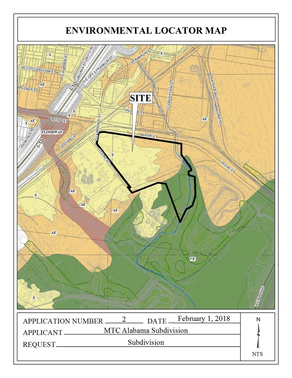
1 # 2 SUB MTC ALABAMA SUBDIVISION Engineering Comments: FINAL PLAT COMMENTS (should be addressed prior to submitting the FINAL PLAT for review and/or signature by the City Engineer): A. Provide all of the required information on the SUBDIVISION PLAT (i.e. signature blocks, signatures, certification statements, written legal description, required notes, legend, scale, bearings and distances) that is required by the current Alabama State Board of Licensure for Professional Engineers and Land Surveyors. B. Label the Proposed LOT with an appropriate designator (i.e. LOT 1, LOT A) C. Add a vicinity map. D. Provide a written legal description. E. Show and label all of the curves listed in the curve table. F. Show and label the MFFE (Minimum Finished Floor Elevation) on each lot that contains an AE, V, or X (shaded) flood zone designation. G. Show and label each and every Right-Of-Way and easement. H. Provide and label the monument set or found at each subdivision corner. I. Add a signature block for the Owner, Notary Public, Planning Commission, Traffic Engineer, and City Engineer. J. Provide the Owner s (notarized), Planning Commission, and Traffic Engineering signatures. K. The proposed CITY OF MOBILE DRAINAGE EASEMENT will need to be revised. The area along the east property line is receiving drainage from a public street and will require a PUBLIC (Dedicated to the City of Mobile) drainage easement; the width and alignment of the easement shall be coordinated with, and approved by, the City Engineer prior to submitting the Plat for signatures. L. National Wetlands Inventory (NWI) mapping, as shown on City of Mobile GIS information, indicates that there is potential for wetlands within the property or properties shown on this plat. Show and label the delineated wetlands, or provide a note that the wetlands shown on this plat are scaled from the NWI data and have not been delineated. M. Add a note that a 25' riparian buffer may be required, during development, along the edge of anything considered by ADEM to be a water of the state. N. Add a note to the SUBDIVISION PLAT stating that a Land Disturbance permit will be required for any land disturbing activity in accordance with Mobile City Code, Chapter 17, Storm Water Management and Flood Control); the City of Mobile, Alabama Flood Plain Management Plan (1984); and, the Rules For Erosion and Sedimentation Control and Storm Water Runoff Control. O. Add a note to the Plat stating that the approval of all applicable federal, state, and local agencies (including all storm water runoff, wetland and floodplain requirements) will be required prior to the issuance of a Land Disturbance permit. P. Add a note that sidewalk is required to be constructed, and/or repaired, along the frontage of each lot, or parcel, at time of new development or construction, unless a sidewalk waiver is approved. Q. Add a note to the plat stating that all easements shall remain in effect until vacated through the proper Vacation process.
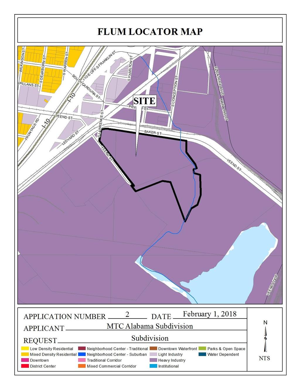
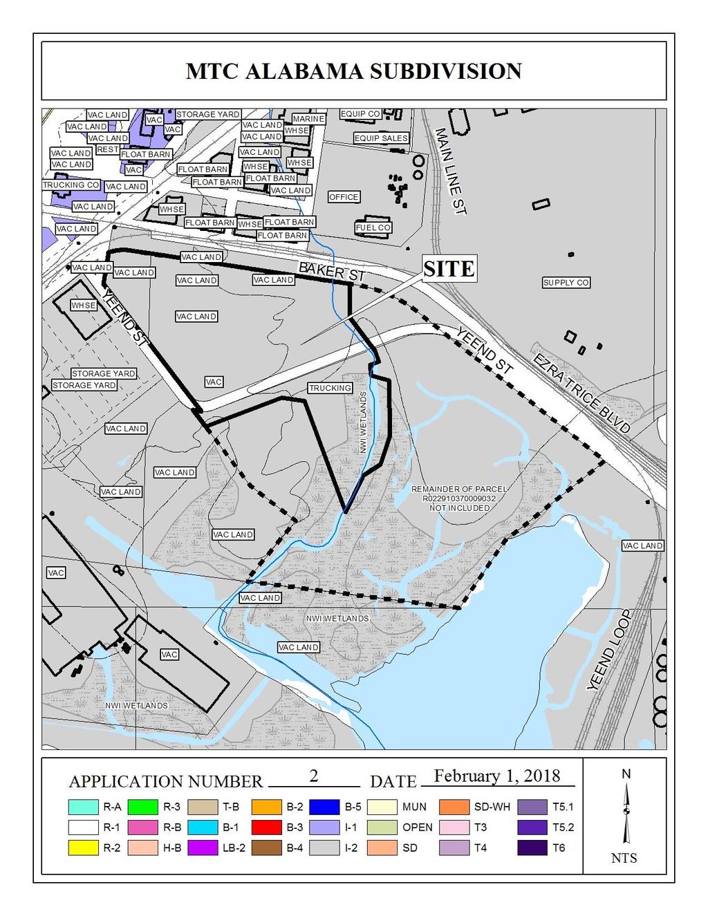
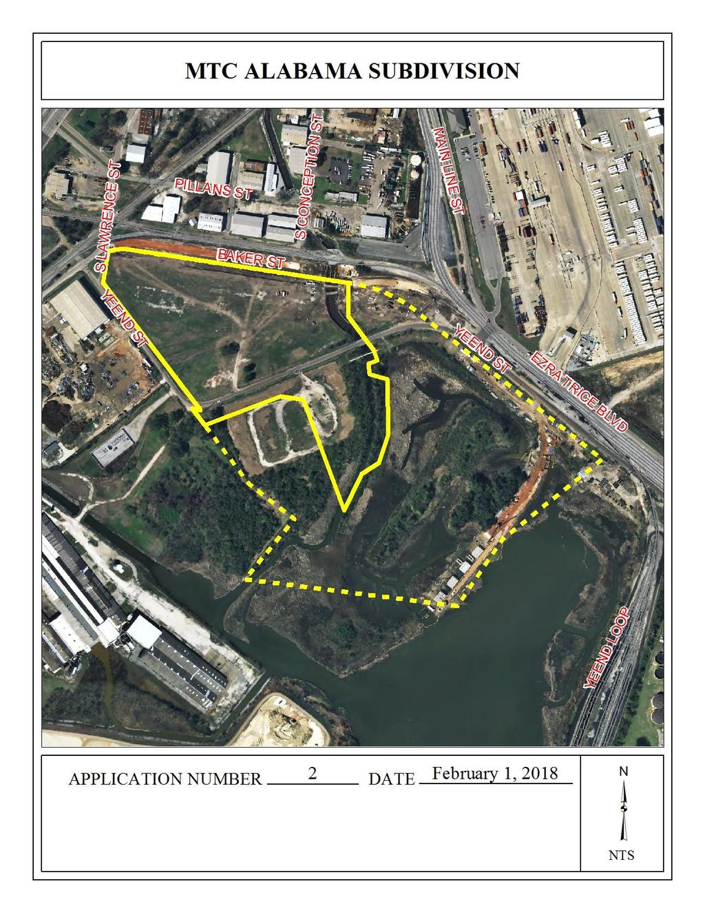
2 # 2 SUB R. Provide a copy of the FINAL SUBDIVISION PLAT to the Engineering Dept. for review. No signatures are required on this drawing. S. After addressing all of the FINAL SUBDIVISION PLAT review comments by the Engineering Dept. provide the ORIGINAL (with all other signatures) and one (1) copy (signatures not required) of the revised Final Plat to the Engineering Department. Traffic Engineering Comments: Lot is denied access to S Lawrence Street, and limited to two curb cuts each to Yeend Street and Baker Street. Driveway size, location and design to be approved by Traffic Engineering and conform to AASHTO standards. Any new on-site parking, including ADA handicap spaces, shall meet the minimum standards as defined in Section 64-6 of the City s Zoning Ordinance. Urban Forestry Comments: Property to be developed in compliance with state and local laws that pertain to tree preservation and protection on both city and private properties (State Act and City Code Chapters 57 and 64.) Fire Department Comments: All projects within the City Limits of Mobile shall comply with the requirements of the City of Mobile Fire Code Ordinance (2012 International Fire Code.) MAWSS Comments: No comments. The plat illustrates the proposed 1-lot, 18.0± acre subdivision located at the Southwest corner of Baker Street and South Lawrence Street extending to the North side of Yeend Street, Council District 3. The applicant states the site is served by public water and sanitary sewer. The site has been given a Heavy Industry (HI) land use designation, per the recently adopted Future Land Use Plan and Map. The Future Land Use Plan and Map complements and provides additional detail to the Development Framework Maps in the Map for Mobile, adopted by the Planning Commission at its November 5, 2015 meeting. This land use designation mostly applies to larger parcels primarily developed to high-impact industrial activity which is preferably removed from residential and commercial uses. Light industry, industrial business or heavy commercial lands may separate heavy industry from other land uses. Heavy industrial areas include collection, treatment, and manufacturing processes which use raw materials, are distinguished by the presence of noise, vibration, and/or odors, and benefit from easy access to a multimodal freight transportation network. Certain types of heavy industry are characterized by low building coverage and activities that rely on large areas of outdoor storage of raw material stockpiles and/or waste-product disposal areas, storage tanks, pipelines, and transportation yards to handle the transfer of heavy materials. The outdoor storage areas should be screened as much as possible by the nature of the stored materials. Land designated as HI may be underdeveloped due to the presence of wetlands on portions of the parcel. In these cases, the wetlands may serve to buffer surrounding uses from the potential impacts of the heavy industrial use. Undeveloped areas of HI parcels that have tree cover may be - 2 -
3 # 2 SUB used as buffering between the heavy industrial use and other uses. Where buffers do not exist naturally, they should be provided as spelled out in the zoning and subdivision regulations. Open areas reserved for dredge disposal are also designated as HI and may contain wetlands. In Mobile, port terminal facilities, docks, shipyards, drydocks, etc., are mostly owned by the State of Alabama. Although not subject to local zoning, these facilities are shown as heavy industrial uses in the FLUM. It should be noted that the Future Land Use Plan and Map components of the Map for Mobile Plan are meant to serve as a general guide, not a detailed lot and district plan. In many cases the designation on the new Future Land Use Map may match the existing use of land, but in others the designated land use may differ from what is on the ground today. As such, the Future Land Use Plan and Map allows the Planning Commission and City Council to consider individual cases based on additional information such as the classification request, the surrounding development, the timing of the request, and the appropriateness and compatibility of the proposed use and, where applicable, the zoning classification. The site currently consists of three metes-and-bounds parcels. Only one parcel (R ) is included in its entirety in the Subdivision. The other two parcels (R and R ) are only partially included. Normally, all portions of any parcels to be subdivided must either be included within proposed lots or within the boundaries of the over-all Subdivision and designated as future development area. This is intended to allow for an orderly progression of land division. However, in this instance, staff has determined the portions of the two parcels which have been excluded will be allowed to remain as future development areas and will be reviewed at such time that they are proposed to be developed. The site also consists of a portion of vacated public right-of-way of Yeend Street which staff has determined should assume the surrounding I-2, Heavy Industry, zoning with the recording of the Final Plat for the Subdivision. The Subdivision would have frontages along Baker Street, South Lawrence Street and Yeend Street. As only a very short portion of Baker Street at South Lawrence Street is on the Major Street Plan, no right-of-way dedication will be required as the existing right-of-way will be used. However, a corner radius dedication of 25 would be required at the intersection of Baker Street and South Lawrence Street, and at the intersection of South Lawrence Street and Yeend Street. As per the Traffic Engineering comments, the Lot should be denied access to South Lawrence Street, and limited to two curb cuts each to Yeend Street and Baker Street. The driveway size, location and design should be approved by Traffic Engineering and conform to AASHTO standards. The proposed lot meets the minimum size requirements of the Subdivision Regulations. However, no lot size is provided on the plat. The plat should be revised to label the lot with its size in both square feet and acres, after any required dedications, or a table should be furnished on the Final Plat providing the same information. The plat should be revised to illustrate a 25 minimum building setback line along all public street frontages
4 # 2 SUB Numerous easements, utilities rights-of-way and agreements to allow utilities are indicated on the plat; therefore, a note should be required on the Final Plat stating that no structures may be constructed or placed within any easements, utilities rights-of-way or utilities agreements. It appears that there may not currently be public sidewalks along any of the public street frontages. It should be noted that the Subdivision triggers the sidewalk requirement along all street frontages at such time when new development is proposed for the site. Based on the preceding, the plat meets the minimum requirements of the Subdivision Regulations and is recommended for Tentative Approval subject to the following conditions: 1) dedication to provide 25 corner radii at the intersection of Baker Street and South Lawrence Street, and at the intersection of South Lawrence Street and Yeend Street; 2) placement of a note on the Final Plat stating that the lot is denied access to South Lawrence Street, and limited to two curb cuts each to Yeend Street and Baker Street, with the size, location and design to be approved by Traffic Engineering and conform to AASHTO standards; 3) revision of the plat to label the lot with its size in both square feet and acres, after any required dedications, or the furnishing of a table on the Final Plat providing the same information; 4) revision of the plat to illustrate a 25 minimum building setback line along all public street frontages; 5) placement of a note on the Final Plat stating that no structures may be constructed or placed within any easements, utilities rights-of-way or utilities agreements; 6) compliance with the Engineering comments: [FINAL PLAT COMMENTS (should be addressed prior to submitting the FINAL PLAT for review and/or signature by the City Engineer): A. Provide all of the required information on the SUBDIVISION PLAT (i.e. signature blocks, signatures, certification statements, written legal description, required notes, legend, scale, bearings and distances) that is required by the current Alabama State Board of Licensure for Professional Engineers and Land Surveyors. B. Label the Proposed LOT with an appropriate designator (i.e. LOT 1, LOT A) C. Add a vicinity map. D. Provide a written legal description. E. Show and label all of the curves listed in the curve table. F. Show and label the MFFE (Minimum Finished Floor Elevation) on each lot that contains an AE, V, or X (shaded) flood zone designation. G. Show and label each and every Right-Of-Way and easement. H. Provide and label the monument set or found at each subdivision corner. I. Add a signature block for the Owner, Notary Public, Planning Commission, Traffic Engineer, and City Engineer. J. Provide the Owner s (notarized), Planning Commission, and Traffic Engineering signatures. K. The proposed CITY OF MOBILE DRAINAGE EASEMENT will need to be revised. The area along the east property line is receiving drainage from a public street and will require a PUBLIC (Dedicated to the City of Mobile) drainage easement; the width and alignment of the easement shall be coordinated with, and approved by, the City Engineer prior to submitting the Plat for signatures. L. National Wetlands Inventory (NWI) mapping, as shown on City of Mobile GIS information, indicates that there is potential for wetlands within the property or properties shown on this plat. Show and label the delineated wetlands, or provide a note that the wetlands shown on this plat - 4 -
5 # 2 SUB are scaled from the NWI data and have not been delineated. M. Add a note that a 25' riparian buffer may be required, during development, along the edge of anything considered by ADEM to be a water of the state. N. Add a note to the SUBDIVISION PLAT stating that a Land Disturbance permit will be required for any land disturbing activity in accordance with Mobile City Code, Chapter 17, Storm Water Management and Flood Control); the City of Mobile, Alabama Flood Plain Management Plan (1984); and, the Rules For Erosion and Sedimentation Control and Storm Water Runoff Control. O. Add a note to the Plat stating that the approval of all applicable federal, state, and local agencies (including all storm water runoff, wetland and floodplain requirements) will be required prior to the issuance of a Land Disturbance permit. P. Add a note that sidewalk is required to be constructed, and/or repaired, along the frontage of each lot, or parcel, at time of new development or construction, unless a sidewalk waiver is approved. Q. Add a note to the plat stating that all easements shall remain in effect until vacated through the proper Vacation process. R. Provide a copy of the FINAL SUBDIVISION PLAT to the Engineering Dept. for review. No signatures are required on this drawing. S. After addressing all of the FINAL SUBDIVISION PLAT review comments by the Engineering Dept. provide the ORIGINAL (with all other signatures) and one (1) copy (signatures not required) of the revised Final Plat to the Engineering Department.]; 7) compliance with the Traffic Engineering comments: (Lot is denied access to S Lawrence Street, and limited to two curb cuts each to Yeend Street and Baker Street. Driveway size, location and design to be approved by Traffic Engineering and conform to AASHTO standards. Any new on-site parking, including ADA handicap spaces, shall meet the minimum standards as defined in Section 64-6 of the City s Zoning Ordinance.); 8) compliance with the Urban Forestry comments: [Property to be developed in compliance with state and local laws that pertain to tree preservation and protection on both city and private properties (State Act and City Code Chapters 57 and 64.)]; and 9) compliance with the Fire Department comments: [All projects within the City Limits of Mobile shall comply with the requirements of the City of Mobile Fire Code Ordinance (2012 International Fire Code.)]; - 5 -
6

7
8
9
10
11
12
BROADWAY THREE NOTCH ROAD SUBDIVISION
 # 3 SUB-000803-2018 BROADWAY THREE NOTCH ROAD SUBDIVISION Engineering Comments: FINAL PLAT COMMENTS (should be addressed prior to submitting the FINAL PLAT for review and/or signature by the City Engineer):
THE WHEELER BUILDING SUBDIVISION
 THE WHEELER BUILDING SUBDIVISION Engineering Comments: FINAL PLAT COMMENTS (should be addressed prior to submitting the FINAL PLAT for review and/or signature by the City Engineer): A. Provide all of the
DAUPHIN CREEK ESTATES SUBDIVISION
 # 12 SUB-000076-2017 DAUPHIN CREEK ESTATES SUBDIVISION Engineering Comments: FINAL PLAT COMMENTS (should be addressed prior to submitting the FINAL PLAT for review and/or signature by the City Engineer):
ALBA BEACH SUBDIVISION, RESUBDIVISION OF LOT 17
 ALBA BEACH SUBDIVISION, RESUBDIVISION OF LOT 17 Engineering Comments: FINAL PLAT COMMENTS (should be addressed prior to submitting the FINAL PLAT for acceptance and signature by the City Engineer): A.
PLANNED UNIT DEVELOPMENT & SUBDIVISION STAFF REPORT Date: September 15, 2016
 # 10 SUB2016-00089 PLANNED UNIT DEVELOPMENT & SUBDIVISION STAFF REPORT Date: September 15, 2016 NAME SUBDIVISION NAME LOCATION Lot 12 Laughlin Industrial Park Subdivision Lot 12 Laughlin Industrial Park
THE CITY OF MOBILE, ALABAMA
 THE CITY OF MOBILE, ALABAMA LE 'I IER OF DECISION Kimberly Clark Mobile Operations 200 Africatown Blvd. Prichard, AL 36610 Re: 100 & 200 Africatown Boulevard (Northeast corner of Bay Bridge Road and Paper
HAWTHORNE PLACE SUBDIVISON, RESUBDIVISION OF LOT 15 REVISED
 # 10 SUB-000336-2017 HAWTHORNE PLACE SUBDIVISON, RESUBDIVISION OF LOT 15 REVISED Engineering Comments: FINAL PLAT COMMENTS (should be addressed prior to submitting the FINAL PLAT for review and/or signature
MOBILE TOWERS SUBDIVISION
 # 3 SUB2014-00100 MOBILE TOWERS SUBDIVISION Engineering Comments: The following comments should be addressed prior to submitting the FINAL PLAT for acceptance and signature by the City Engineer: 1) Provide
WESTMINSTER PARK PLACE SUBDIVISION
 WESTMINSTER PARK PLACE SUBDIVISION Engineering Comments: FINAL PLAT COMMENTS (should be addressed prior to submitting the FINAL PLAT for review and/or signature by the City Engineer): A. Provide all of
SUBDIVISION, PLANNING APPROVAL, & REZONING STAFF REPORT Date: June 4, 2015
 SUBDIVISION, PLANNING APPROVAL, & REZONING STAFF REPORT Date: June 4, 2015 APPLICANT NAME SUBDIVISION NAME DEVELOPMENT NAME LOCATION Board of Water & Sewer Commissioners of the City of Mobile MAWSS MLK
ZONING AMENDMENT & SUBDIVISION STAFF REPORT Date: March 1, 2018
 #13 SUB-000406-2018 & ZON-000407-2018 ZONING AMENDMENT & SUBDIVISION STAFF REPORT Date: March 1, 2018 NAME SUBDIVISION NAME LOCATION Creekside @ Kooiman Dairy Creekside @ Kooiman Dairy Subdivision (South
WESTMINSTER PARK SUBDIVISION
 WESTMINSTER PARK SUBDIVISION Engineering Comments: FINAL PLAT COMMENTS (should be addressed prior to submitting the FINAL PLAT for review and/or signature by the City Engineer): A. Provide all of the required
SUBDIVISION & PLANNING APPROVAL STAFF REPORT Date: December 1, 2016
 SUBDIVISION & PLANNING APPROVAL STAFF REPORT Date: December 1, 2016 APPLICANT NAME SUBDIVISION NAME DEVELOPMENT NAME LOCATION Board of Water and Sewer Commissioners of the City of Mobile Halls Mill Road
TULSA PARK ESTATES SUBDIVISION, RESUBDIVISION OF LOT 6
 TULSA PARK ESTATES SUBDIVISION, RESUBDIVISION OF LOT 6 Engineering Comments: FINAL PLAT COMMENTS (should be addressed prior to submitting the FINAL PLAT for review and/or signature by the City Engineer):
ZONING AMENDMENT & SUBDIVISION STAFF REPORT Date: July 3, 2014
 ZONING AMENDMENT & SUBDIVISION STAFF REPORT Date: July 3, 2014 APPLICANT NAME SUBDIVISION NAME LOCATION Georgia Crown Distributing Subdivision Georgia Crown Distributing Subdivision Southwest corner of
JOHNNY S RV PARK SUBDIVISION
 # 11 SUB2016-00001 JOHNNY S RV PARK SUBDIVISION Engineering Comments: The following comments should be addressed prior to submitting the FINAL PLAT for acceptance and signature by the City Engineer: A.
ZONING AMENDMENT & SUBDIVISION STAFF REPORT Date: July 9, 2015
 ZONING AMENDMENT & SUBDIVISION STAFF REPORT Date: July 9, 2015 APPLICANT NAME 2513 Dauphin Street, Inc. SUBDIVISION NAME Audubon Place Extension No. 3, Resubdivision of Lots 1-5 LOCATION 2513 Dauphin Street
SUBDIVISION, PLANNED UNIT DEVELOPMENT, & REZONING STAFF REPORT Date: September 17, 2015
 SUBDIVISION, PLANNED UNIT DEVELOPMENT, & REZONING STAFF REPORT Date: September 17, 2015 APPLICANT NAME SUBDIVISION NAME DEVELOPMENT NAME LOCATION Daniel Clark Mack Manufacturing Subdivision, Resubdivision
THE CI FY OF MOBILE, ALABAMA
 THE CI FY OF MOBILE, ALABAMA LETTER OF DECISION DewberryiPreble-Rish 9949 Bellaton Avenue Daphne, AL 36526 Re: Area bounded by Foxtail Drive, Lace Bark Drive and Whitebark Drive Council District 6 SUB-000323-2017
DINKINS ESTATE FAMILY SUBDIVISION
 # 9 SUB2015-00122 DINKINS ESTATE FAMILY SUBDIVISION Engineering Comments: The following comments should be addressed prior to submitting the FINAL PLAT for acceptance and signature by the City Engineer:
THE CITY OF MOBILE, ALABAMA
 THE CITY OF MOBILE, ALABAMA LETTER OF DECISION Dominion Senior Living of West Mobile, LLC 1200 Corporate Dr., St. 225 Birmingham, AL 35242 Re: 6924 Somerbv Lane (North terminus of Somerby Lane). Council
PLANNED UNIT DEVELOPMENT & SUBDIVISION STAFF REPORT August 18, 2016
 PLANNED UNIT DEVELOPMENT & SUBDIVISION STAFF REPORT August 18, 2016 DEVELOPMENT NAME SUBDIVISION NAME Mullinax Ford Subdivision Mullinax Ford Subdivision LOCATION CITY COUNCIL DISTRICT District 6 Southeast
PLANNED UNIT DEVELOPMENT & SUBDIVISION STAFF REPORT Date: July 20, 2017
 PLANNED UNIT DEVELOPMENT & SUBDIVISION STAFF REPORT Date: July 20, 2017 DEVELOPMENT NAME SUBDIVISION NAME LOCATION Rangeline Crossing III Subdivision Rangeline Crossing III Subdivision 5289 Halls Mill
PLANNED UNIT DEVELOPMENT & SUBDIVISION STAFF REPORT Date: April 18, 2019
 PLANNED UNIT DEVELOPMENT & SUBDIVISION STAFF REPORT Date: April 18, 2019 DEVELOPMENT NAME SUBDIVISION NAME Springhill Village Subdivision Springhill Village Subdivision LOCATION 4350, 4354, 4356, 4358,
AMENDMENT TO REGULATING PLAN & SUBDIVISION STAFF REPORT Date: December 15, 2016
 AMENDMENT TO REGULATING PLAN & SUBDIVISION STAFF REPORT Date: December 15, 2016 NAME SUBDIVISION NAME Gulf States Engineering- Mathew C. Roberts, PLS Precision Engineering Subdivision LOCATION CITY COUNCIL
ZONING AMENDMENT & SUBDIVISION STAFF REPORT Date: November 3, 2016
 ZONING AMENDMENT & SUBDIVISION STAFF REPORT Date: November 3, 2016 APPLICANT NAME SUBDIVISION NAME David Shumer 5955 Airport Subdivision CITY COUNCIL DISTRICT District 6 5955 Airport Boulevard, 754 Linlen
ZONING AMENDMENT, PLANNED UNIT DEVELOPMENT & SUBDIVISION STAFF REPORT Date: August 8, 2013
 ZONING AMENDMENT, PLANNED UNIT DEVELOPMENT & SUBDIVISION STAFF REPORT Date: August 8, 2013 NAME SUBDIVISION NAME PV-Magnolia, LLC Twelve Trees Subdivision LOCATION 2860, 2862 and 2866 Pleasant Valley Road
THE CITY OF MOBILE, ALABAMA
 THE CITY OF MOBILE, ALABAMA LETTER OF DECISION March 9, 2018 Byrd Surveying, Inc. 2609 Halls Mill Road Mobile, AL 36606 Re: 4439 Rangeline Road (Northwest corner of Rangeline Road and Halls Mill Road).
THE CITY OF MOBILE, ALABAMA
 THE CITY OF MOBILE, ALABAMA LETTER OF DECISION Dewberry I Preble-Rish 9949 Bellaton Avenue Daphne, AL 36526 Re: 6050 & 6086 Whitebark Drive (North side of Girby Road, 125'± East of Bristlecone Drive, extending
PLANNED UNIT DEVELOPMENT & SUBDIVISION STAFF REPORT Date: November 17, 2016
 PLANNED UNIT DEVELOPMENT & SUBDIVISION STAFF REPORT Date: November 17, 2016 DEVELOPMENT NAME SUBDIVISION NAME LOCATION Autonation Ford of Mobile Autonation Ford of Mobile Subdivision 901, 909, and 925
SUBDIVISION, PLANNED UNIT DEVELOPMENT, ZONING AMENDMENT, & SIDEWALK WAIVER STAFF REPORT Date: July 19, 2018
 SUBDIVISION, PLANNED UNIT DEVELOPMENT, ZONING AMENDMENT, & SIDEWALK WAIVER STAFF REPORT Date: July 19, 2018 NAME SUBDIVISION NAME LOCATION West Mobile Properties, LLC U.S. Machine Subdivision 556, 566,
ZONING AMENDMENT & SUBDIVISION STAFF REPORT Date: June 18, 2015
 ZONING AMENDMENT & SUBDIVISION STAFF REPORT Date: June 18, 2015 APPLICANT NAME SUBDIVISION NAME EAA LLC / Eryka Rogers Aaiden Place Subdivision LOCATION 2480 Government Boulevard (North side of Government
PLANNED UNIT DEVELOPMENT & ZONING AMENDMENT STAFF REPORT Date: December 21, 2017
 # 14 PUD-000324-2017 & ZON-000326-2017 PLANNED UNIT DEVELOPMENT & ZONING AMENDMENT STAFF REPORT Date: December 21, 2017 APPLICANT NAME DEVELOPMENT NAME LOCATION Dewberry/Preble-Rish Longleaf Gates Subdivision,
# 14 SUB CANAL SUBDIVISION
 CANAL SUBDIVISION Engineering Comments: Label each Lot showing the required minimum finished floor elevation (MFFE). It appears that Lots 2, 3 & 4 are located in the AE Flood Zone; add a note to the plat
KRONER S MOBILE WEST COMMERCIAL BUSINESS PARK SUBDIVISION
 KRONER S MOBILE WEST COMMERCIAL BUSINESS PARK SUBDIVISION Engineering Comments: Must comply with the Mobile County Flood Damage Prevention Ordinance. Development shall be designed to comply with the storm
# 1 HOLDOVER Revised SUB CANAL SUBDIVISION
 CANAL SUBDIVISION Engineering Comments: Label each Lot showing the required minimum finished floor elevation (MFFE). It appears that Lots 2, 3 & 4 are located in the AE Flood Zone; add a note to the plat
PLANNED UNIT DEVELOPMENT, SIDEWALK WAIVER, & SUBDIVISION STAFF REPORT Date: November 6, 2008
 PLANNED UNIT DEVELOPMENT, SIDEWALK WAIVER, & SUBDIVISION STAFF REPORT Date: November 6, 2008 DEVELOPMENT NAME SUBDIVISION NAME LOCATION Frascati Shops, Inc. Frascati Subdivision 1120 Paper Mill Road CITY
PLANNED UNIT DEVELOPMENT STAFF REPORT Date: October 19, 2017
 PLANNED UNIT DEVELOPMENT STAFF REPORT Date: October 19, 2017 DEVELOPMENT NAME LOCATION Custom Boat Storage 3975 Demetropolis Road (East side of Demetropolis Road, 0.2± miles South of Halls Mill Road.)
STONE HEDGE SUBDIVISION, UNIT 1, RESUBDIVISION OF LOT 40 & WEST COMMON AREA
 # 5 SUB-000498-2018 STONE HEDGE SUBDIVISION, UNIT 1, RESUBDIVISION OF LOT 40 & WEST COMMON AREA Engineering Comments: Must comply with the Mobile County Flood Damage Prevention Ordinance. Development shall
MCGOWIN PARK EAST OF SATCHEL PAIGE SUBDIVISION, RESUBDIVISION OF
 # 14 SUB2015-00058 MCGOWIN PARK EAST OF SATCHEL PAIGE SUBDIVISION, RESUBDIVISION OF Engineering Comments: The following comments should be addressed prior to submitting the FINAL PLAT for acceptance and
COCHRAN FAMILY RIVERSIDE ESTATE SUBDIVISION
 # 19 SUB2012-00111 COCHRAN FAMILY RIVERSIDE ESTATE SUBDIVISION Engineering Comments: The following comments should be addressed prior to review, acceptance and signature by the City Engineer: 1. Label/show
KLUGE PLACE SUBDIVISION
 KLUGE PLACE SUBDIVISION Engineering Comments: Must comply with the Mobile County Flood Damage Prevention Ordinance. Development shall be designed to comply with the storm water detention and drainage facility
BETTA STOR-IT SUBDIVISION
 BETTA STOR-IT SUBDIVISION Engineering Comments: Must comply with all storm water and flood control ordinances. Any increase in impervious area in excess of 4,000 square feet will require detention. Any
HERON LANDING SUBDIVISION
 HERON LANDING SUBDIVISION Engineering Comments: Per FEMA guidelines, any development greater than 5 acres in size or subdivision 50 lots in size, requires a flood study. Width of drainage easement to be
AMELIA LAKE SUBDIVISON, PHASES 1-2
 # 1 HOLDOVER Revised SUB2014-00089 AMELIA LAKE SUBDIVISON, PHASES 1-2 Engineering Comments: Must comply with the Mobile County Flood Damage Prevention Ordinance. Development shall be designed to comply
McGowin Park, LLC. B-3, Community Business District
 # 10, 11, 12 SUB2014-00024 ZON2014-00500 ZON2014-00501 SUBDIVISION, PLANNED UNIT DEVELOPMENT (East), PLANNED UNIT DEVELOPMENT (West) STAFF REPORT Date: April 3, 2014 DEVELOPMENT NAME LOCATION McGowin Park,
AUTUMNDALE SUBDIVISION, RESUBDIVISION OF LOTS
 AUTUMNDALE SUBDIVISION, RESUBDIVISION OF LOTS 100-102 Engineering Comments: Road shall be constructed per City standards and according to the City s street acceptance process. Cul-de sac approval subject
DAWES SWITCHING STATION SUBDIVISION
 DAWES SWITCHING STATION SUBDIVISION Engineering Comments: Must comply with the Mobile County Flood Damage Prevention Ordinance. Development shall be designed to comply with the storm water detention and
ZONING AMENDMENT, PLANNED UNIT DEVELOPMENT & SUBDIVISION STAFF REPORT Date: September 15, 2011
 ZONING AMENDMENT, PLANNED UNIT DEVELOPMENT & SUBDIVISION STAFF REPORT Date: September 15, 2011 NAME SUBDIVISION NAME LOCATION Stratford, L.L.C. Grelot Office Park Subdivision North side of Grelot Road,
NOBLE DRIVE EAST SUBDIVISION
 NOBLE DRIVE EAST SUBDIVISION Engineering Comments: Must comply with the Mobile County Flood Damage Prevention Ordinance. Development shall be designed to comply with the storm water detention and drainage
TERRY POIROUX FAMILY DIVISION SUBDIVISION
 TERRY POIROUX FAMILY DIVISION SUBDIVISION Engineering Comments: Must comply with the Mobile County Flood Damage Prevention Ordinance. Development shall be designed to comply with the storm water detention
ZONING AMENDMENT & SUBDIVISION STAFF REPORT Date: March 7, 2013
 # 4 & 5 SUB2012-00141 & ZON2012-03157 HOLDOVER ZONING AMENDMENT & SUBDIVISION STAFF REPORT Date: March 7, 2013 APPLICANT NAME SUBDIVISION NAME LOCATION Garrard Development Services, LLC Michigan & Bay
DEER RIVER COMMERCIAL PARK SUBDIVISION
 DEER RIVER COMMERCIAL PARK SUBDIVISION Engineering Comments: Must comply with the Mobile County Flood Damage Prevention Ordinance. Development shall be designed to comply with the storm water detention
SOUTHERN INDUSTRIAL PARK SUBDIVISION, LOT A, RESUBDIVISION OF LOTS 7 & 8
 SOUTHERN INDUSTRIAL PARK SUBDIVISION, LOT A, RESUBDIVISION OF LOTS 7 & 8 Engineering Comments: Need to increase width of existing easement to include an area at least 20 from the top of the existing ditch,
THE CITY OF MOBILE, ALABAMA MOBILE Crry PLANNING COMMISSION
 THE CITY OF MOBILE, ALABAMA MOBILE Crry PLANNING COMMISSION LETTER OF DECISION MLK Avenue Redevelopment Corp. Attn: Michael Pierce P.O. Box 2204 Mobile, AL 36652 Re: Case #SUB2014-00040 (Subdivision) MLK
SUBDIVISION, PLANNED UNIT DEVELOPMENT, & PLANNING APPROVAL STAFF REPORT Date: February 1, 2007
 SUBDIVISION, PLANNED UNIT DEVELOPMENT, & PLANNING APPROVAL STAFF REPORT Date: February 1, 2007 DEVELOPMENT NAME SUBDIVISION NAME Pala Verde Mobile Home Park Subdivision Pala Verde Mobile Home Park Subdivision
PENNY LAKES SUBDIVISION
 PENNY LAKES SUBDIVISION Engineering Comments: A portion of the site may be located within the J.B. Converse watershed, the primary drinking water supply for the Mobile Area Water and Sewer System. Consultation
SUBDIVISION, PLANNED UNIT DEVELOPMENT, & REZONING STAFF REPORT Date: March 23, 2017
 SUBDIVISION, PLANNED UNIT DEVELOPMENT, & REZONING STAFF REPORT Date: March 23, 2017 APPLICANT NAME SUBDIVISION NAME DEVELOPMENT NAME LOCATION Sarah & Michael Stashak Old Shell at Ashland Place Subdivision
MOBILE CITY PLANNING COMMISSION LETTER OF DECISION. June 3, 2011
 MOBILE CITY PLANNING COMMISSION LETTER OF DECISION P.O. Box 421 Mobile, AL 36601 Re: Case #SUB2011-00029 (Subdivision) Alabama West Subdivision, Unit Four 2600 McVay Drive North (North side of McVay Drive
ZONING AMENDMENT & PLANNED UNIT DEVELOPMENT STAFF REPORT Date: June 7, 2012
 ZONING AMENDMENT & PLANNED UNIT DEVELOPMENT STAFF REPORT Date: June 7, 2012 NAME DEVELOPMENT NAME LOCATION Mayo Blackmon Mayo Blackmon 1446 Navco Road & 2452 McLaughlin Drive. (North side of McLaughlin
PORT CITY COMMERCE PARK SUBDIVISION
 # 4 SUB2015-00019 PORT CITY COMMERCE PARK SUBDIVISION Engineering Comments: Must comply with the Mobile County Flood Damage Prevention Ordinance. Development shall be designed to comply with the storm
THE BLUFFS AT CYPRESS CREEK SUBDIVISION, PHASE ONE
 THE BLUFFS AT CYPRESS CREEK SUBDIVISION, PHASE ONE Engineering Comments: Shipyard Road shall be constructed to City Standard up through proposed Cypress Park Drive. Show Minimum FFE on plans and plat.
ZONING AMENDMENT & PLANNED UNIT DEVELOPMENT STAFF REPORT Date: July 5, 2012
 ZONING AMENDMENT & PLANNED UNIT DEVELOPMENT STAFF REPORT Date: July 5, 2012 NAME DEVELOPMENT NAME LOCATION Mayo Blackmon Mayo Blackmon 1446 Navco Road & 2452 McLaughlin Drive. (North side of McLaughlin
ZONING AMENDMENT, SUBDIVISION & SIDEWALK WAIVER REQUEST STAFF REPORT Date: November 16, 2006
 ZONING AMENDMENT, SUBDIVISION & SIDEWALK WAIVER REQUEST STAFF REPORT Date: November 16, 2006 NAME SUBDIVISION NAME Terhaar & Cronley Investment Partnership P & E Subdivision LOCATION 4210 and 4218 Halls
MAGNOLIA SPRINGS SUBDIVISION, PHASE ONE
 MAGNOLIA SPRINGS SUBDIVISION, PHASE ONE Engineering Comments: Must comply with the Mobile County Flood Damage Prevention Ordinance. Development shall be designed to comply with the storm water detention
PLANNED UNIT DEVELOPMENT & SUBDIVISION STAFF REPORT Date: March 15, 2007
 PLANNED UNIT DEVELOPMENT & SUBDIVISION STAFF REPORT Date: March 15, 2007 DEVELOPMENT NAME SUBDIVISION NAME LOCATION Motormax Subdivision Motormax Subdivision 2917 and 2929 Government Boulevard (South side
ZONING AMENDMENT STAFF REPORT Date: September 15, 2016
 ZONING AMENDMENT STAFF REPORT Date: September 15, 2016 NAME LOCATION Clear Water, LLC 3490 Hurricane Bay Road (Northeast corner of Hurricane Bay Road and Hurricane Bay Lane) CITY COUNCIL DISTRICT District
APPLICANT NAME SUBDIVISION NAME DEVELOPMENT NAME LOCATION. CITY COUNCIL DISTRICT Council District 4 PRESENT ZONING PROPOSED ZONING
 SUBDIVISION, PLANNED UNIT DEVELOPMENT, PLANNING APPROVAL, ZONING AMENDMENT, & SIDEWALK WAIVER REQUEST STAFF REPORT Date: February 17, 2010 APPLICANT NAME SUBDIVISION NAME DEVELOPMENT NAME LOCATION David
SUBDIVISION, PLANNED UNIT DEVELOPMENT, PLANNING APPROVAL, ZONING AMENDMENT, & SIDEWALK WAIVER REQUEST STAFF REPORT Date: February 17, 2010
 SUBDIVISION, PLANNED UNIT DEVELOPMENT, PLANNING APPROVAL, ZONING AMENDMENT, & SIDEWALK WAIVER REQUEST STAFF REPORT Date: February 17, 2010 APPLICANT NAME SUBDIVISION NAME DEVELOPMENT NAME LOCATION David
ELIZA JORDAN CORNER SUBDIVISION
 ELIZA JORDAN CORNER SUBDIVISION Engineering Comments: Must comply with the Mobile County Flood Damage Prevention Ordinance. Development shall be designed to comply with the storm water detention and drainage
TURTLE CREEK SUBDIVISION, PHASE THREE
 TURTLE CREEK SUBDIVISION, PHASE THREE Engineering Comments: Must comply with the Mobile County Flood Damage Prevention Ordinance. Development shall be designed to comply with the storm water detention
BAY FOREST PARK SUBDIVISION, RESUBDIVISION OF LOTS 6 & 7 AND BAY FOREST PARK SUBDIVISION LOT 10, OF THE RESUBDIVISON OF LOTS 9 & 10
 BAY FOREST PARK SUBDIVISION, RESUBDIVISION OF LOTS 6 & 7 AND BAY FOREST PARK SUBDIVISION LOT 10, OF THE RESUBDIVISON OF LOTS 9 & 10 Engineering Comments: Must comply with the Mobile County Flood Damage
APPLICATION PROCEDURE
 ANTRIM PLANNING BOARD P. O. Box 517 Antrim, New Hampshire 03440 Phone: 603-588-6785 FAX: 603-588-2969 APPLICATION FORM AND CHECKLIST FOR MINOR OR MAJOR SITE PLAN REVIEW File Date Received By APPLICATION
ZONING AMENDMENT, & SUBDIVISION STAFF REPORT Date: May 17, 2007
 ZONING AMENDMENT, & SUBDIVISION STAFF REPORT Date: May 17, 2007 APPLICANT NAME SUBDIVISION NAME LOCATION Christopher J. Nix, Agent Mobile Central Subdivision 2570, 2590, & 2598 Government Boulevard (Northeast
OAK HILL SUBDIVISION
 OAK HILL SUBDIVISION Engineering Comments: Must comply with the Mobile County Flood Damage Prevention Ordinance. MAWSS Comments: MAWSS has no water or sewer services available. The plat illustrates the
ZONING AMENDMENT, PLANNED UNIT DEVELOPMENT & SUBDIVISION STAFF REPORT Date: March 5, 2009
 ZONING AMENDMENT, PLANNED UNIT DEVELOPMENT & SUBDIVISION STAFF REPORT Date: March 5, 2009 NAME SUBDIVISION NAME LOCATION Kentress Morrisette Booker T. Washington Highlands Subdivision, First Addition,
Time Extension Staff Report
 Time Extension Staff Report Subdivision Name Lunara Subdivision File Number SUB07-00019 Approval Time Extension for Lead Agency Boise City Certification Signature of Boise City Engineer Annexation Date
PALMER WOODS SUBDIVISION, PHASE III
 PALMER WOODS SUBDIVISION, PHASE III Engineering Comments: Must comply with the Mobile County Flood Damage Prevention Ordinance. MAWSS Comments: MAWSS has NO water and sewer services available. The plat
ARTICLE 9 SPECIFICATIONS FOR DOCUMENTS TO BE SUBMITTED
 ARTICLE 9 SPECIFICATIONS FOR DOCUMENTS TO BE SUBMITTED SECTION 950 GENERALLY All applications shall be properly signed and filed by the owner or, with the owner s specific written consent, a contract purchaser
Residential Major Subdivision Review Checklist
 Residential Major Subdivision Review Checklist Plan Submittal Requirements: 2 full sets of stamped plans Electric submittal - all plans contained in a single PDF 3 full sets if commercial kitchen or dining
THE BLUFFS AT CYPRESS CREEK SUBDIVISION
 THE BLUFFS AT CYPRESS CREEK SUBDIVISION Engineering Comments: Must comply with all stormwater and flood control ordinances. Any work performed in the right-of-way will require a right-of-way permit. Traffic
# 6 Case #SUB LEGACY SUBDIVISION. Engineering Comments: Must comply with the Mobile County Flood Damage Prevention Ordinance.
 LEGACY SUBDIVISION Engineering Comments: Must comply with the Mobile County Flood Damage Prevention Ordinance. The plat illustrates the proposed 46 lot, 26.7 + acres subdivision which is located on the
ZONING AMENDMENT, PLANNED UNIT DEVELOPMENT & PLANNING APPROVAL STAFF REPORT Date: June 7, 2007
 ZONING AMENDMENT, PLANNED UNIT DEVELOPMENT & PLANNING APPROVAL STAFF REPORT Date: June 7, 2007 NAME LOCATION Johnny Randall Cotton and Angela K. Cotton 4800 Tufts Road (West side of Tufts Road, 50 ± North
Township of Little Egg Harbor Planning Board 665 Radio Road Little Egg Harbor, New Jersey Phone: ext. 221 Fax:
 BLOCK(S) LOT(S) Township of Little Egg Harbor Planning Board 665 Radio Road Little Egg Harbor, New Jersey 08087 Phone: 609-296-7241 ext. 221 Fax: 609-294-3040 Development Application Amended Development
I. Requirements for All Applications. C D W
 108-16.1. Application checklists. Checklist for Required Submissions to the Planning Board or Zoning Board of Adjustment of Monroe Township All required submissions are to be made to the Administrative
MASTER SUBDIVISION FINAL PLAT APPLICATION Town of Apex, North Carolina
 MASTER SUBDIVISION FINAL PLAT APPLICATION Town of Apex, North Carolina This document is a public record under the North Carolina Public Records Act and may be published to the Town s website or disclosed
JEFFERSON COUNTY, ALABAMA
 JEFFERSON COUNTY, ALABAMA Major Development Checklist, Notes and Information A Major Development is any proposed new structure or addition to an existing structure which will cause a change in the topography
DAWES OAK SUBDIVISION
 DAWES OAK SUBDIVISION Engineering Comments: Must comply with the Mobile County Flood Damage Prevention Ordinance. The plat illustrates the proposed 82-lot, 28.1± acre subdivision, which is located on the
PICKENS COUNTY UNIFIED DEVELOPMENT STANDARDS ORDINANCE. Organization of the Ordinance
 PICKENS COUNTY UNIFIED DEVELOPMENT STANDARDS ORDINANCE Organization of the Ordinance Article 1. Article 2. Article 3. Article 4. Article 5. Article 6. Article 7. Adoption, Applicability and Interpretation
MOBILE CITY PLANNING COMMISSION LETTER OF DECISION. August 19, 2011
 Case #SUB2011-00082 (Subdivision) Subdivision (West side of Demetropolis Road, 1900 + South of Cottage Hill Road). Number of Lots / Acres: 1 Lot / 12.5± Acres Engineer / Surveyor: Driven Engineering, Inc.
MAJOR SUBDIVISION PRELIMINARY PLAT CHECKLIST
 TOWNSHIP OF EGG HARBOR PLANNING BOARD/ZONING BOARD OF ADJUSTMENT 3515 BARGAINTOWN ROAD EGG HARBOR TOWNSHIP, NJ 08234 MAJOR SUBDIVISION PRELIMINARY PLAT CHECKLIST The following checklist is designed to
PLANNING BOARD CITY OF CONCORD, NH MINOR SUBDIVISION CHECKLIST
 PLANNING BOARD CITY OF CONCORD, NH MINOR SUBDIVISION CHECKLIST Summary This checklist is intended to assist applicants and design professionals in the preparation of minor subdivision applications for
MINOR SUBDIVISION FINAL PLAT APPLICATION Town of Apex, North Carolina
 MINOR SUBDIVISION FINAL PLAT APPLICATION Town of Apex, North Carolina This document is a public record under the North Carolina Public Records Act and may be published on the Town s website or disclosed
Residential Minor Subdivision Review Checklist
 Residential Minor Subdivision Review Checklist Plan Submittal Requirements: 2 full sets of stamped plans Electric submittal - all plans contained in a single PDF 3 full sets if commercial kitchen or dining
MINOR SUBDIVISION PLAT CHECKLIST
 MINOR SUBDIVISION PLAT CHECKLIST Project Name: Tax ID #: Project Number: Date: _ Reviewed By: Telephone: NOTES: All lots on septic systems must comply with the Fulton County Health Department requirements
TOWNSHIP OF BORDENTOWN LAND DEVELOPMENT APPLICATION CHECKLIST. General Requirements for all Applications
 TOWNSHIP OF BORDENTOWN LAND DEVELOPMENT APPLICATION CHECKLIST This CHECKLIST has been adopted in accordance with Section 25:807 of the Land Development Ordinance of the Township of Bordentown and will
PARK PLACE SUBDIVISION
 PARK PLACE SUBDIVISION Engineering Comments: Must comply with the Mobile County Flood Damage Prevention Ordinance. The plat illustrates the proposed 53 lot, 12.6 + acres subdivision which is located on
PLANNED UNIT DEVELOPMENT & SUBDIVISION STAFF REPORT Date: May 6, 2004
 # 3. & 4. File # ZON2004-00967 & SUB2004-00085 PLANNED UNIT DEVELOPMENT & SUBDIVISION STAFF REPORT Date: May 6, 2004 DEVELOPMENT NAME SUBDIVISION NAME Heron Lakes Subdivision, Phase One, Revised Lot 32
PROVISION POINTE SUBDIVISION
 PROVISION POINTE SUBDIVISION Engineering Comments: Must comply with the Mobile County Flood Damage Prevention Ordinance. Development shall be designed to comply with the storm water detention and drainage
SUBDIVISION AND LAND DEVELOPMENT. 185 Attachment 20
 185 Attachment 20 APPENDIX S Plat No. Date of Submission Twp. Fee $ Dauphin Co. Fee $ TOWNSHIP OF DERRY SUBDIVISION OR LAND DEVELOPMENT PLAN SUBMISSION APPLICATION This block for Twp. use only 1. Title