SINGLE-FAMILY WETLAND CERTIFICATION PROCESS
|
|
|
- Kristopher Gibbs
- 5 years ago
- Views:
Transcription

1 SINGLE-FAMILY WETLAND CERTIFICATION PROCESS Listed below is a step-by-step process for expediting wetland reviews for single-family development. It is called the Single-Family Certification Process. It shall only be used for single-family development outside regulated wetlands or buffers. This process shall be used for single-family homes and associated features such as garages, fences, lawns, septic fields, and wells. The single-family wetland certification can only be used one time for one single-family residence and one detached garage. It shall not be used for new agricultural activities, including pole barns, forest practice activities, land division, ADUs, or mother-inlaw dwellings. The certification form shall not be used for compliance with Chapter 18E.40 Regulated Fish and Wildlife Species and Habitat Conservation Areas. This process is intended to assist the single-family property owner, but it must be noted that the property owner is responsible for any errors committed by the biologist, for complying with all wetland regulations, and for providing mitigation if damage occurs to wetlands or buffers. 1) Pierce County staff will check for wetland indicators on the Pierce County Geographical Information System, CountyView, and/or QuickView when requested to complete a Critical Areas and Resource Lands (CARLS) Checklist for a specific parcel. This information will be used to determine if jurisdictional wetlands may exist on the property and if wetland review is required. Wetland indicators include Pierce County inventoried wetlands, Department of Natural Resources stream mapping, the National Wetland Inventory (NWI), hydric soils, and flood zones A and B. Not all wetlands within Pierce County have been inventoried. Your property may have wetlands or buffers even if no indicators are mapped. If you suspect that your property contains a wetland or buffer, you should consider having your site inspected by a private biologist in order to avoid an inadvertent violation of the law. 2) If one or more wetland indicators are identified within 315 feet of a proposed regulated activity, the site will need to be inspected prior to issuance of any permits or performing the activity. A regulated activity includes, but is not limited to, any construction, filling, grading, logging, clearing or altering vegetation (see attached list of regulated activities). 3) The Single-Family Wetland Certification shall be used when a private wetland specialist can certify that there are no regulated wetlands within 315 feet of the proposed activity, or that any regulated activity will occur outside the wetland and buffer areas. Both the certification and site plan must be signed by a wetland specialist recognized by Pierce County. The Single-Family Wetland Certification form is valid for one year from date of specialist s signature. A list of Pierce County private wetland specialists is available at the Pierce County Development Center. 4) The County will allow continued processing of the building permit with no additional wetland review If the wetland specialist demonstrates that all regulated activities will be located outside of the wetland buffer. 5) The Single-Family Wetland Certification must be signed and dated by the property owner to show that he/she agrees to allow Pierce County staff to enter the property, that he/she understands that the County reserves the right to deny acceptance of incorrect or inaccurate certifications, and that he/she is responsible for limiting all regulated activity to areas outside of wetlands and their buffers.
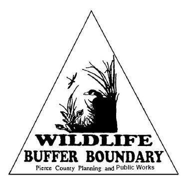
2 6) If a wetland or wetland buffer is located on the property within 315 feet of the proposed activity, a wetland specialist must install blue wetland buffer boundary signs along the outer edge of the required wetland buffer to distinguish the areas to be left undisturbed and protected (see attached standards). 7) If there are regulated wetland buffers within 315 feet of the proposed activity, the following actions must be completed prior to submitting the certification form: a. The Wetland Specialist must place wetland buffer signs at the edge of the buffer. b. The Wetland Specialist must complete and sign a declaration of buffer posting (attached). c. The declaration is to be submitted along with the certification form but does not need to be recorded. d. Prior to submitting the certification form for review it must be recorded at the Pierce County Auditor s Office in accordance with Sections 18E F. 8) If a regulated activity is proposed within a wetland, standard buffer, or building setback, the certification form cannot be used, and the formal Single-Family Wetland Application process must be followed. This process is defined in Section 18E C.2. Note: Please consult a current fee schedule for Wetland Certification and other wetland application review fees. 18E Regulated Uses and Activities B. The following activities are regulated within critical fish and wildlife habitat areas, wetlands, aquifer recharge area, landslide hazard areas, erosion hazard areas, flood hazard areas, and/or their buffers unless exempted by Section 18E : 1. Removing, excavating, disturbing, or dredging soil, sand, gravel, minerals, organic matter, or materials of any kind; 2. Dumping, discharging or filling; 3. Draining, flooding or disturbing the water level or water table. In addition, an activity which involves intentional draining, flooding or disturbing the water level or water table in a wetland or stream in which the activity itself occurs outside the regulated area shall be considered a regulated activity; 4. Driving, piling or placing obstructions, including placement of utilities; 5. Constructing, reconstructing, demolishing, or altering the size of any structure or infrastructure; 6. Altering the character of a regulated area by destroying or altering vegetation through clearing, harvesting, cutting, intentional burning, shading, or planting; 7. Activities which result in significant changes in water temperature or physical or chemical characteristics of wetland or stream water sources, including changes in quantity of water and pollutant level; 8. Application of pesticides, fertilizers and/or other chemicals unless demonstrated not to be harmful to the regulated area; 9. The division or redivision of land pursuant to Title 18F, PCC and boundary line adjustments; 10. The creation of impervious surfaces.
3
4 CRITICAL AREA BUFFER BOUNDARY SIGN STANDARDS In compliance with Pierce County Ordinance No s, s, effective March 1, 2007, Title 18E Development Regulations-Critical Areas, the following standards apply to the placement of the permanent buffer boundary signs: WETLAND BUFFER SIGNS: Size: 4 x 6 rectangle Color: Black lettering on azure blue background Wording: WETLAND BUFFER BOUNDARY PIERCE COUNTY PLANNING AND PUBLIC WORKS STREAM BUFFER SIGNS: Size: 6 x 4 rectangle Color: Black lettering on azure blue background Wording: STREAM BUFFER BOUNDARY PIERCE COUNTY PLANNING AND PUBLIC WORKS WILDLIFE BUFFER SIGNS: Size: 6 triangle Color: Black lettering on azure blue background Wording: WILDLIFE BUFFER BOUNDARY PIERCE COUNTY PLANNING AND PUBLIC WORKS POSTING REQUIREMENTS: The signs shall face away from the critical area and must be placed on posts installed securely in the ground. Posts can be metal or wood. If wood posts are used, they must be at least 2 x 2 in size and be made of treated wood. Posts must extend a minimum of three feet above ground and be sunk at least two feet below ground. Additional sign requirements, such as installation upon fencing instead of posts, may be applied at the discretion of the County Biologist. The following companies have templates for the buffer signs that are required by Pierce County regulations for development in areas containing wetlands, streams, and wildlife areas: Cole Graphic Solutions 4901 Center Street Tacoma, WA (253) Tacoma Signwriters 3153 Soundview Drive West Tacoma, WA (253)


5 BUFFER BOUNDARY SIGNS One sign every 30 to 50 feet. Attach to a metal or wood fence post. One sign every 30 to 50 feet. Attach to a metal or wood fence post. One sign every 30 to 50 feet. Attach to a metal or wood fence post.
 permanent Pierce County-approved Wetland, Stream, or Fish &")
6 DECLARATION OF POSTING CRITICAL AREA BUFFER BOUNDARY SIGNS AND/OR SURVEY MARKERS APPLICATION NO(S). Signs: I, _, applicant/agent for the project associated with the application number above, state that on the day of, I affixed (number) permanent Pierce County-approved Wetland, Stream, or Fish & Wildlife signs, prominently displayed at the outer edge of the buffer. Markers: I,, applicant/agent for the project associated with the application number above, state that on the day of, I affixed (number) permanent Pierce County-approved Wetland, Stream, or Fish & Wildlife signs, prominently displayed at the outer edge of the buffer. Tax Parcel No.: Site address: I certify (or declare) under penalty of perjury under the laws of the State of Washington that the foregoing is true and correct: Signed on, 20, at, Date City State Signature Print Name Pierce County Planning and Public Works, 2401 South 35 th Street, Tacoma, Washington
7 Recording Requirements Overview Recording is the process of maintaining an index, scanning a clear image, and making your document public record. Currently records are available online dating back to Blank documents can be found at a office supply/stationery store or a local title insurance company. At the time of recording all documents must be fully completed, signed, and notarized. The Auditor s office does not provide notary services or legal advice. Recording Requirements First page must have a 3 inch top margin and 1 inch margins on the sides and bottom. Additional pages must have 1 inch margins on all sides. First Page Requirements Return address in upper left corner, within the top 3 margin Document title Name of grantor and grantee, with reference to page where additional names are located Abbreviated legal description, with reference to page where complete legal is located Reference number(s) if referencing a previously recorded document Assessor s tax parcel number, if the document contains a legal description If required information does not appear on the first page of the document, a cover sheet must be completed listing all of the necessary information. General Requirements Page size may not exceed 8 1/2 by 14 inches Font size must be 8 point or larger Information on all pages must be legible and reproducible, including map pages Paper and ink must be of weight and color capable of producing a legible image No attachments are permitted (i.e. stapled/taped notary acknowledgement, legals, etc) Documents that do not meet the Standard Recording Requirements may be recorded for an additional $50.00 fee Attach a cover sheet that is provided by our office. The non-standard recording request must be completed and signed by the document preparer. Documents that must be recorded immediately and which do not meet margin and font size requirements may be recorded for an additional fee of $50.00 per RCW This cover sheet must be attached to each non-compliant document. Regular fees apply, PLUS the $50.00 additional fee, and will be due on each non-compliant document. Nonstandard documents are NOT EXEMPT from the requirement that they be fully legible. Non-standard documents must be legible Find more information about requirements in RCWs and Contact Us Phone: , Address: 2401 S. 35th St. Room 200, Tacoma, WA Hours: 8:30 a.m. - 4:30 p.m., Monday Friday, PCAUDITOR@co.pierce.wa.us.
THIS DECLARATION OF RESTRICTIVE COVENANTS is made this day of, 20, by ("Covenantor"). RECITALS
. RECITALS") Model for Use with Permits Without Mitigation Plans STATE OF COUNTY OF DECLARATION OF RESTRICTIVE COVENANTS THIS DECLARATION OF RESTRICTIVE COVENANTS is made this day of, 20, by ("Covenantor"). RECITALS
Model for Use with Permits Without Mitigation Plans STATE OF COUNTY OF DECLARATION OF RESTRICTIVE COVENANTS THIS DECLARATION OF RESTRICTIVE COVENANTS is made this day of, 20, by ("Covenantor"). RECITALS
CONSERVATION EASEMENT INCLUDING MITIGATION
 After recording return to: GRANTOR: GRANTEE: GRANTEE (Trustee): LEGAL DESCRIPTION: TAX PARCEL I.D. #: REFERENCE # s: WHATCOM COUNTY N/A CONSERVATION EASEMENT INCLUDING MITIGATION This grant of a conservation
LAND USE APPLICATION
 LAND USE APPLICATION File Name: File No(s).: Receipt No.: Receipt Date: Received By: Amount.: $ Instructions for Applicants Please read and follow all instructions on your application carefully. If you
Land Use Application
 Land Use Application Check all permits you are applying for in the boxes provided. Submit this application form, the applicable materials listed in the corresponding permit application packet(s) and application
PLANNING & DEVELOPMENT SERVICES 1800 Continental Place Mount Vernon, WA Inspections Office Fax 360.
 PLANNING & DEVELOPMENT SERVICES 1800 Continental Place Mount Vernon, WA 98273 Inspections 360.416.1330 Office 360.416-1320 Fax 360.416-1340 Date Received: Administrative Setback Reduction Checklist Pursuant
City of Leavenworth DEPARTMENT OF DEVELOPMENT SERVICES MAJOR SUBDIVISION APPLICATION 1
 Proposed Name of Subdivision: City of Leavenworth DEPARTMENT OF DEVELOPMENT SERVICES MAJOR SUBDIVISION APPLICATION 1 FOR PRELIMINARY SUBDIVISION APPROVAL This application must be filled out legibly, in
BRISTOL CONSERVATION COMMISSION INLAND WETLANDS AGENCY FORM IW-1 (Application for a Wetlands Permit)
") APPLICATION NO. BRISTOL CONSERVATION COMMISSION INLAND WETLANDS AGENCY FORM IW-1 (Application for a Wetlands Permit) DATE FILED: APPROVED: DENIED: 1. APPLICANT: Name: Signature: Address: City: State: Zip
APPLICATION NO. BRISTOL CONSERVATION COMMISSION INLAND WETLANDS AGENCY FORM IW-1 (Application for a Wetlands Permit) DATE FILED: APPROVED: DENIED: 1. APPLICANT: Name: Signature: Address: City: State: Zip
BOUNDARY LINE ADJUSTMENT
 DEPARTMENT OF COMMUNITY DEVELOPMENT 621 Sheridan Street, Port Townsend, WA 98368 Tel: 360.379.4450 Fax: 360.379.4451 Web: www.co.jefferson.wa.us/communitydevelopment E-mail: dcd@co.jefferson.wa.us BOUNDARY
PERMIT FEES Within the shore impact zone (Includes Rip-Rap and Sand Blankets) $ Over 51 cubic yards $100.00
 $ Over 51 cubic yards $100.00") WHAT IS A LAND ALTERATION PERMIT? A land alteration permit is a permit to move or excavate dirt, gravel, sand, etc, on property, which is not incidental to an approved building permit or a septic system
WHAT IS A LAND ALTERATION PERMIT? A land alteration permit is a permit to move or excavate dirt, gravel, sand, etc, on property, which is not incidental to an approved building permit or a septic system
MODEL DEED RESTRICTION FOR THE PENNSYLVANIA STATE PROGRAMMATIC GENERAL PERMIT-3 (PASPGP-3) DECLARATION OF RESTRICTIVE COVENANTS FOR CONSERVATION
 DECLARATION OF RESTRICTIVE COVENANTS FOR CONSERVATION") MODEL DEED RESTRICTION FOR THE PENNSYLVANIA STATE PROGRAMMATIC GENERAL PERMIT-3 (PASPGP-3) DECLARATION OF RESTRICTIVE COVENANTS FOR CONSERVATION THIS DECLARATION OF RESTRICTIVE COVENANTS FOR CONSERVATION
MODEL DEED RESTRICTION FOR THE PENNSYLVANIA STATE PROGRAMMATIC GENERAL PERMIT-3 (PASPGP-3) DECLARATION OF RESTRICTIVE COVENANTS FOR CONSERVATION THIS DECLARATION OF RESTRICTIVE COVENANTS FOR CONSERVATION
Skamania County Community Development Department
 Skamania County Community Development Department Skamania County Courthouse Annex Post Office Box 790 Stevenson, Washington 98648 509 427-3900 FAX: 866 266-1534 Section I. Overview SEPTIC PROCESS 1. Application:
Chapter 136. SOIL EROSION
 1 of 8 12/19/2011 4:17 PM Township of Andover, NJ Monday, December 19, 2011 Chapter 136. SOIL EROSION [HISTORY: Adopted by the Township Committee of the Township of Andover by Ord. No. 77-11 (Ch. XVII
Land Use Application
 Permit Center 210 Lottie Street, Bellingham, WA 98225 Phone: (360) 778-8300 Fax: (360) 778-8301 TTY: (360) 778-8382 Email: permits@cob.org Web: www.cob.org/permits Land Use Application Check all permits
THIS DEED OF CONSERVATION EASEMENT
 NOTICE TO TITLE EXAMINERS: THIS DEED OF CONSERVATION EASEMENT CONTAINS COVENANTS THAT INCLUDE RESTRICTIONS ON THE USE, SUBDIVISION AND OFF-CONVEYANCE OF LAND. THIS DEED OF CONSERVATION EASEMENT ("Conservation
Kitsap County Hearing Examiner
 January 25, 2016 ADMINISTRATION BUILDING, 619 DIVISION ST, MS-36 PORT ORCHARD, WA 98366 http://www.kitsapgov.com/dcd/lu_env/he/ (360) 337-5777 NOTICE OF HEARING EXAMINER DECISION To: Interested Parties
Boundary Line Adjustment / Lot Combination General Instructions and Submittal Forms
 CITY OF TENINO PO BOX 4019 149 Hodgden Street South Tenino, WA 98589-4019 Phone (360) 264-2368 FAX (360) 264-5772 Boundary Line Adjustment / Lot Combination General Instructions and Submittal Forms The
STAFF REPORT and INFORMATION FOR THE HEARING EXAMINER. Project: Westphal Accessory Dwelling Unit (ADU)
") KITSAP COUNTY DEPARTMENT OF COMMUNITY DEVELOPMENT 614 DIVISION STREET MS-36, PORT ORCHARD WASHINGTON 98366-4682 LARRY KEETON, DIRECTOR (360) 337-7181 FAX (360) 337-4925 HOME PAGE - www.kitsapgov.com STAFF
KITSAP COUNTY DEPARTMENT OF COMMUNITY DEVELOPMENT 614 DIVISION STREET MS-36, PORT ORCHARD WASHINGTON 98366-4682 LARRY KEETON, DIRECTOR (360) 337-7181 FAX (360) 337-4925 HOME PAGE - www.kitsapgov.com STAFF
BEFORE THE HEARING EXAMINER FOR THURSTON COUNTY
 COUNTY COMMISSIONERS Cathy Wolfe District One Diane Oberquell District Two Robert N. Macleod District Three HEARING EXAMINER BEFORE THE HEARING EXAMINER FOR THURSTON COUNTY In the Matter of the Application
CONSERVATION EASEMENT AND RESTRICTION
 CONSERVATION EASEMENT AND RESTRICTION The purpose of a Conservation Easement is to protect in perpetuity significant natural features and to minimize the environmental impact of activities associated with
SHORT PLAT Information
 Information This form provides information and an explanation of the procedures of a Short Plat. If you have any questions, contact the Planning and Development Services Department at (253) 566-5656. A
CHAPTER 13 WINCHESTER WETLANDS BYLAW
 CHAPTER 13 WINCHESTER WETLANDS BYLAW Section 1. PURPOSE The purpose of this by-law is to protect the wetlands, related water resources, and adjoining land areas in the town by prior review and control
CITY OF CHELAN WHEN ARE CONFERENCES HELD? ARE ENGINEERED PLANS REQUIRED?
 CITY OF CHELAN PRE-APPLICATION CONFERENCE WHAT IS IT? A pre-application conference is an informal meeting between a project applicant and members of the City of Chelan and other local, state, and federal
City of Leavenworth DEPARTMENT OF DEVELOPMENT SERVICES SALE OF CONSUMER FIREWORKS PERMIT APPLICATION 1
 City of Leavenworth DEPARTMENT OF DEVELOPMENT SERVICES SALE OF CONSUMER FIREWORKS PERMIT APPLICATION 1 This application must be filled out legibly, in black ink, either hand printed or typewritten APPLICANT:
DECLARATION OF RESTRICTIVE COVENANTS
 STATE OF MARYLAND COUNTY OF DECLARATION OF RESTRICTIVE COVENANTS THIS DECLARATION OF RESTRICTIVE COVENANTS is made this day of, 20, by ( Declarant(s) ). RECITALS WHEREAS, Declarant(s) is/are the owner(s)
Town of Lisbon, Maine SUBDIVISION REVIEW APPLICATION
 Date Received: Fee Paid (amount): Applicant: Town of Lisbon, Maine SUBDIVISION REVIEW APPLICATION Subdivision Name/Title: This application must be received at the Town Office by close of business on the
APPLICATION FOR PERMIT: (Pursuant to Ord & Reso ) 4d Habitat Loss Permit Vegetation Removal Tree Removal. Address:
 4d Habitat Loss Permit Vegetation Removal Tree Removal. Address:") CITY OF ESCONDIDO Planning Division 201 North Broadway Escondido, CA 92025-2798 (760) 839-4671 Fax: (760) 839-4313 APPLICATION FOR PERMIT: (Pursuant to Ord. 91-54 & Reso. 94-436) Case No: FOR INTERNAL
CITY OF ESCONDIDO Planning Division 201 North Broadway Escondido, CA 92025-2798 (760) 839-4671 Fax: (760) 839-4313 APPLICATION FOR PERMIT: (Pursuant to Ord. 91-54 & Reso. 94-436) Case No: FOR INTERNAL
New Service Application
 Dear Applicant: Thank you for contacting Inland Power & Light and inquiring about new electrical service. We have provided the following checklist to assist you in providing the documentation we require
SUBMITTAL REQUIREMENTS: The number indicates the number of copies for submittal (if applicable).
.") Office Use Only Preliminary Long Plat Long Subdivision Applicant Checklist PLANNING, COMMUNITY, & ECONOMIC DEVELOPMENT DEPARTMENT FINAL LONG PLAT LONG SUBDIVISION CHECKLIST Mailing Address: P.O. Box 547,
Office Use Only Preliminary Long Plat Long Subdivision Applicant Checklist PLANNING, COMMUNITY, & ECONOMIC DEVELOPMENT DEPARTMENT FINAL LONG PLAT LONG SUBDIVISION CHECKLIST Mailing Address: P.O. Box 547,
A. Maintenance. All legally established, nonconforming structures can be maintained (e.g., painting and repairs);
;") Chapter 24.50 NONCONFORMING USES, STRUCTURES AND LOTS Sections: 24.50.010 Nonconforming uses, structures, and lots Purpose. 24.50.020 Nonconforming uses, structures, and lots Alteration or expansion of
Chapter 24.50 NONCONFORMING USES, STRUCTURES AND LOTS Sections: 24.50.010 Nonconforming uses, structures, and lots Purpose. 24.50.020 Nonconforming uses, structures, and lots Alteration or expansion of
PARTIAL SUBMITTALS WILL NOT BE ACCEPTED. REQUIRED MATERIALS FOR A COMPLETE APPLICATION ARE:
 CITY OF MONROE Community Development Department 806 West Main Street Monroe, WA 98272 Phone: (360) 794-7400 Fax: (360) 794-4007 Land Clearing / Forest Practices Permit Requirements LAND CLEARING PERMIT
CONDITIONAL USE PERMIT Application Packet
 CONDITIONAL USE PERMIT Application Packet Community Development Department 1020 East Pioneer Road, Draper, UT 84020 (801) 576-6539 Fax (801) 576-6526 Dear Applicant, This application packet has been developed
Chelan County Department of Community Development 316 Washington Street, Suite 301, Wenatchee, WA Telephone: (509) Fax: (509)
 Fax: (509)") Chelan County Department of Community Development 316 Washington Street, Suite 301, Wenatchee, WA 98801 Telephone: (509) 667-6225 Fax: (509) 667-6475 Boundary Line Adjustment Type or Print Legibly in Black
Chelan County Department of Community Development 316 Washington Street, Suite 301, Wenatchee, WA 98801 Telephone: (509) 667-6225 Fax: (509) 667-6475 Boundary Line Adjustment Type or Print Legibly in Black
19.12 CLUSTER RESIDENTIAL DISTRICT
 Chapter 19.12 CLUSTER RESIDENTIAL DISTRICT (Adopted 12/22/2003; Ordinance #0061970). Amended 7/3/17, Ordinance #079100. Section 19.12.010 - Declaration of Intent. The Cluster Residential District provides
204 Minor Subdivision & Large Lot Division
 204 Minor Subdivision & Large Lot Division 204.01 Purpose and Intent 204.05 General Procedures 204.10 Large Lot Division 204.02 Comprehensive Land Use 204.06 Submittal Requirements Plan Policies 204.07
Will Controlling Your Legacy Durable Power of Attorney Durable Power for Health Care Medical Directives Community Property Agreement Transfer on Death
 Estate Planning & PROBATE Real Property Transfers Jeff Heimark Vicki Heimark, LPO Dano Law Firm, P.S. Will Controlling Your Legacy Durable Power of Attorney Durable Power for Health Care Medical Directives
CHAPTER 3 PRELIMINARY PLAT
 10-3-1 10-3-3 SECTION: CHAPTER 3 PRELIMINARY PLAT 10-3-1: Consultation 10-3-2: Filing 10-3-3: Requirements 10-3-4: Approval 10-3-5: Time Limitation 10-3-6: Grading Limitation 10-3-1: CONSULTATION: Each
FINAL SITE PLAN PLAT APPLICATION Town of Apex, North Carolina
 FINAL SITE PLAN PLAT APPLICATION Town of Apex, North Carolina This document is a public record under the North Carolina Public Records Act and may be published on the Town s website or disclosed to third
Construction & Earthwork Request Form (CERF)
") ShoreLand Traditions Construction & Earthwork Request Form (CERF) SECTION 1 SECTION 2 SECTION 3 Definitions and Points to Remember Requirements and Process Site Sketch Requirements and Sample If you have
ShoreLand Traditions Construction & Earthwork Request Form (CERF) SECTION 1 SECTION 2 SECTION 3 Definitions and Points to Remember Requirements and Process Site Sketch Requirements and Sample If you have
Town of Mansfield RDA Instructions: -Fill out WPA Form 1 as noted. -Submit a site sketch* showing:
 Town of Mansfield RDA Instructions: -Fill out WPA Form 1 as noted -Submit a site sketch* showing: subject property area of the work proposed footprint of any new structures approximate location of the
FRESHWATER WETLANDS PROTECTION IN NEW JERSEY Tools for Municipal Action
 FRESHWATER WETLANDS PROTECTION IN NEW JERSEY Tools for Municipal Action The Freshwater Wetlands Protection Act INTENT OF FRESHWATER WETLANDS LAW The New Jersey legislature passed the Freshwater Wetlands
Larimer County Planning Dept. Procedural Guide for 1041 PERMITS
 - Larimer County Planning Dept. Procedural Guide for 1041 PERMITS PLEASE NOTE: A PRE-APPLICATION CONFERENCE IS REQUIRED PRIOR TO SUBMITTING THIS APPLICATION. PURPOSE: State Statutes allow local governments
Staff Report. Conditional Use Permit: Williams Tree and Stump Removal. Application Number: Tax Parcel Numbers:
 Pierce County Department of Planning and Land Services, 2401 South 35th Street, Tacoma, WA (253) 798-7037 Staff Report Conditional Use Permit: Williams Tree and Stump Removal Application Number: 836154
PLANNING CLEARANCE. Planning Clearance is required prior to the submittal of most building and development permit applications.
 PLANNING CLEARANCE Description Planning Clearance is the County s review of the site plan for a proposed development, and is the starting point for most of the County s permitting processes, including
MAJOR SUBDIVISION PRELIMINARY PLAT CHECKLIST
 TOWNSHIP OF EGG HARBOR PLANNING BOARD/ZONING BOARD OF ADJUSTMENT 3515 BARGAINTOWN ROAD EGG HARBOR TOWNSHIP, NJ 08234 MAJOR SUBDIVISION PRELIMINARY PLAT CHECKLIST The following checklist is designed to
SUBMITTAL REQUIREMENTS: The number indicates the number of copies for submittal (if applicable).
.") Office Use Only Preliminary Long Plat Long Subdivision Applicant Checklist PLANNING, COMMUNITY, & ECONOMIC DEVELOPMENT DEPARTMENT PRELIMINARY LONG PLAT LONG SUBDIVISION CHECKLIST Mailing Address: P.O.
Office Use Only Preliminary Long Plat Long Subdivision Applicant Checklist PLANNING, COMMUNITY, & ECONOMIC DEVELOPMENT DEPARTMENT PRELIMINARY LONG PLAT LONG SUBDIVISION CHECKLIST Mailing Address: P.O.
DECLARATION OF RESTRICTIVE COVENANTS. THIS DECLARATION OF RESTRICTIVE COVENANTS made this day of, 200_, by ( Declarant ). RECITALS
. RECITALS") DECLARATION OF RESTRICTIVE COVENANTS THIS DECLARATION OF RESTRICTIVE COVENANTS made this day of, 200_, by ( Declarant ). RECITALS WHEREAS, Declarant is the owner of the surface of certain real property
DECLARATION OF RESTRICTIVE COVENANTS THIS DECLARATION OF RESTRICTIVE COVENANTS made this day of, 200_, by ( Declarant ). RECITALS WHEREAS, Declarant is the owner of the surface of certain real property
APPLICATION. Telephone Fax Address. Telephone Fax Address FOR MARTIN COUNTY USE ONLY
 APPLICATION PRESERVE AREA MANAGEMENT PLAN/ ABBREVIATED PRESERVE AREA MANAGEMENT PLAN Growth Management Department Environmental Division PART 1: Applicant Information A. Land Owner(s) Name Title and Company
Planning Services Division 3675 Mt. Diablo Boulevard, Suite 210 Lafayette, CA Tel. (925) Fax (925)
 Fax (925)") Planning Services Division 3675 Mt. Diablo Boulevard, Suite 210 Lafayette, CA 94549-1968 Tel. (925) 284-1976 Fax (925) 284-1122 www.ci.lafayette.ca.us GRADING PERMIT APPLICATION INSTRUCTIONS GENERAL This
Planning Services Division 3675 Mt. Diablo Boulevard, Suite 210 Lafayette, CA 94549-1968 Tel. (925) 284-1976 Fax (925) 284-1122 www.ci.lafayette.ca.us GRADING PERMIT APPLICATION INSTRUCTIONS GENERAL This
DECLARATION OF RESTRICTIVE COVENANTS
 DECLARATION OF RESTRICTIVE COVENANTS The Declarant,, is the fee simple owner of the certain real property located in County, Kansas, as described on Exhibit A, which is attached hereto and incorporated
MODEL DEED RESTRICTION
 MODEL DEED RESTRICTION This type of Protective Covenant is the most commonly used. It is a legal agreement between the grantor, typically the property owner or applicant, and the Corps. Please view instructions
PRELIMINARY PLAT CHECK LIST
 PRELIMINARY PLAT CHECK LIST Name of Proposed Subdivision: The following items must be included with the initial submittal of a Preliminary Plat: Application, filled out completely Project Narrative Pre-application
Site Development Review for
 Site Development Review for Guide Agriculture Caretaker Dwelling WHAT IS IT? Site Development Review for Agricultural Caretaker Dwelling(s) ensures that placement of new or continued occupancy of temporary
City of Fort Lupton Amended Plat Process
 City of Fort Lupton Amended Plat Process Purpose The Amended Plat process is an administrative process to amend a recorded Plat. An Amended Subdivision is an administrative revision to a recorded Subdivision
Thurston County Planning Department BOARD OF COUNTY COMMISSIONERS PUBLIC HEARING DRAFT AMENDMENTS TO THE CRITICAL AREAS REGULATIONS. Chapter 24.
 Thurston County Planning Department BOARD OF COUNTY COMMISSIONERS PUBLIC HEARING DRAFT AMENDMENTS TO THE CRITICAL AREAS REGULATIONS Chapter 24.01 GENERAL PROVISIONS Chapter 24.01 6/4/2012 GENERAL PROVISIONS
TALBOT COUNTY OFFICE OF PLANNING & ZONING
 TALBOT COUNTY OFFICE OF PLANNING & ZONING APPLICATION PROCEDURE FOR: MINOR VARIANCE CRITICAL AREA Refer to Article, IX, 190-182 B. Minor Variances of the Talbot County Code. If your project exceeds 10
ZONING BOARD OF APPEALS APPLICATION
 ZONING BOARD OF APPEALS APPLICATION Town of Westbrook ZBA Appeal No. Land Use Department Mulvey Municipal Center, 866 Boston Post Road, Connecticut 06498 (860)-399-3047 Fax (860)-399-2084 ZBA App. Fee
Walton County Planning and Development Services
 Walton County Planning and Development Services 31 Coastal Centre Boulevard, Suite 100 47 N 6 th Street Santa Rosa Beach, Florida 32459 DeFuniak Springs, Florida 32433 Phone 850-267-1955 Phone 850-892-8157
APPLICATION FOR EXEMPT SUBDIVISION: NON-LOT SPLIT
 APPLICATION FOR EXEMPT SUBDIVISION: NON-LOT SPLIT ELIGIBILITY Section 12.08.03.c of the Land Development Code provides for review and approval of exempt subdivisions, which shall include any of the following:
WARRANTY DEED INFORMATION PACKET
 WARRANTY DEED INFORMATION PACKET This information can be provided to our customers with the following statement: THERE MAY BE LEGAL AND/OR TAX IMPLICATIONS ONCE THESE FORMS ARE FILED. WE RECOMMEND YOU
WEST VIRGINIA DIVISION OF FORESTRY Cooperative Forest Legacy Program. Sample Conservation Easement
 WEST VIRGINIA DIVISION OF FORESTRY Cooperative Forest Legacy Program Sample Conservation Easement This document is included in the forest legacy kit as an example for information and possible guidance
APPLICATION FOR LOT SPLIT
 APPLICATION FOR LOT SPLIT ELIGIBILITY Section 12.09.01 of the Land Development Code provides for review and approval of lot split, which shall include any of the following: 1. The division of a single
Natural Resource Assessment Submittal Checklist
 WHATCOM COUNTY Planning & Development Services 5280 Northwest Drive Bellingham, WA 98226-9097 360-778-5900, TTY 800-833-6384 360-778-5901 Fax Mark Personius, AICP Director Natural Resource Assessment Submittal
Progressive Review Time Submittal of application and necessary documents
 -SITE DEVELOPMENT / TREE REMOVALBUILDING PERMIT APPLICATION PACKET The following application is to be used for the debrushing and tree removal when not done in conjunction with a site construction project;
MASTER SUBDIVISION FINAL PLAT APPLICATION Town of Apex, North Carolina
 MASTER SUBDIVISION FINAL PLAT APPLICATION Town of Apex, North Carolina This document is a public record under the North Carolina Public Records Act and may be published to the Town s website or disclosed
FINAL PLAT CHECKLIST
 FINAL PLAT CHECKLIST Project Name: Tax ID #: Project Number: Date: _ Reviewed By: Telephone: Please address all items marked with an "X" Please return redline comments with corrected plan, original mylar,
Natural Resource Assessment/ Site Plan Technical Review Application
 Natural Resource Assessment/ Site Plan Technical Review Application Documents Required for Submittal: *NOTES: If a proposal is within the shoreline jurisdiction please use appropriate shoreline application
LAND USE PERMIT APPLICATION
 LAND USE PERMIT APPLICATION Date Application No. TYPE OF PERMIT Subdivision Short Plat Conditional Use Binding Site Plan Final Plat Final Short Plat Variance Final Binding Site Plan Plat Amendment Short
PRELIMINARY PLAT Checklist
 PRELIMINARY PLAT Checklist 3715 Bridgeport Way W University Place, WA 98466 PH: (253) 566-5656 FAX: (253) 460-2541 This is a checklist of materials required for a Preliminary Plat. This checklist is provided
MINOR SUBDIVISION FINAL PLAT APPLICATION Town of Apex, North Carolina
 MINOR SUBDIVISION FINAL PLAT APPLICATION Town of Apex, North Carolina This document is a public record under the North Carolina Public Records Act and may be published on the Town s website or disclosed
MINOR & MAJOR SUBDIVISION APPLICATION
 TOW OF HOOKSETT APPLICATIO # DATE MIOR & MAJOR SUBDIVISIO APPLICATIO Application for: Completeness Map and Lot o. Public Hearing o. of Lots LOCATIO: (Specify Street Address) OWER: APPLICAT: ADDRESS: ADDRESS:
OPEN SPACE TIMBER PROGRAM OKANOGAN COUNTY CODE, CHAPTER 14.09
 OPEN SPACE TIMBER PROGRAM OKANOGAN COUNTY CODE, CHAPTER 14.09 14.09.010 - Short Title 14.09.020 - Purpose 14.09.030 - Administration 14.09.040 - Compliance with Regulations 14.09.050 - Scope 14.09.060
MINOR SUBDIVISION PLAT CHECKLIST
 MINOR SUBDIVISION PLAT CHECKLIST Project Name: Tax ID #: Project Number: Date: _ Reviewed By: Telephone: NOTES: All lots on septic systems must comply with the Fulton County Health Department requirements
Thurston County Planning Department PUBLIC HEARING DRAFT. AMENDMENTS TO THE CRITICAL AREAS REGULATIONS Chapter /18/2011 GENERAL PROVISIONS
 Thurston County Planning Department PUBLIC HEARING DRAFT AMENDMENTS TO THE CRITICAL AREAS REGULATIONS Chapter 24.01 11/18/2011 Chapter 24.01 GENERAL PROVISIONS GENERAL PROVISIONS Sections: 24.01.005 Short
TENTATIVE PARCEL MAP APPLICATION GUIDE TENTATIVE PARCEL MAP APPLICATION REQUIREMENTS
 TENTATIVE PARCEL MAP APPLICATION GUIDE SISKIYOU COUNTY PLANNING DIVISION 806 South Main Street, Yreka CA 96097 Phone: (530) 841-2100 / Fax: (530) 841-4076 TENTATIVE PARCEL MAP APPLICATION REQUIREMENTS
ALREADY SUBMITTED FOR HIGHLANDS COUNCIL PRE
 Highlands Preservation Area Approval Application Checklist Items Block 15901 Lot 1, West Milford See Highlands Council Review at: http://www.highlands.state.nj.us/njhighlands/projectreview/ **For advisory
Parkland-Spanaway-Midland LUAC - Agenda
 1. 6:30 P.M. Parkland-Spanaway-Midland LUAC - Agenda Documents: 8 2 17 PSMAC Agenda.pdf 2. Parkland-Spanaway-Midland LUAC Initial Project Review Documents: Lincoln Court PP IPR PSMAC-RJ.pdf Department
TOWN OF BRASELTON, GEORGIA STREAM BUFFER AND SETBACK VARIANCE APPLICATION
 TOWN OF BRASELTON, GEORGIA STREAM BUFFER AND SETBACK VARIANCE APPLICATION An applicant seeking a grant of variance from the stream buffer protection regulations found in Section 15.5 of the Town of Braselton
Project Information. Request. Required Attachments
 Variance Application Use this form for all variance applications, including administrative reductions in setbacks. A variance application may be accompanied by another permit application that depends on
PREPARED BY PLANNING DEPARTMENT ORANGE COUNTY NORTH CAROLINA
 PREPARED BY PLANNING DEPARTMENT ORANGE COUNTY NORTH CAROLINA Return to: DONNA PUCKETT 1555 NC 56 SUITE 2 CREEDMOOR, NC 27522 DECLARATION OF DEVELOPMENT RESTRICTIONS AND REQUIREMENTS RECORDED CONCURRENTLY
PUBLIC NOTICE. PROPOSED ORDINANCE No. PREDICTABLE FEE SCHEDULE FOR RECORDING STANDARD DOCUMENTS
 PUBLIC NOTICE PROPOSED ORDINANCE No. PREDICTABLE FEE SCHEDULE FOR RECORDING STANDARD DOCUMENTS WHEREAS, the Illinois General Assembly has enacted Public Act 100-0271, effective August 22, 2017, which requires
LAND USE ORDINANCE, TOWN OF RICHMOND, MAINE TABLE OF CONTENTS
 LAND USE ORDINANCE, TOWN OF RICHMOND, MAINE TABLE OF CONTENTS ARTICLE 1. GENERAL A. TITLE... 1 B. PURPOSES... 1 C. BASIC REQUIREMENTS... 1-2 D. ADMINISTRATION & ENFORCEMENT... 2-3 E. VALIDITY AND SEVERABILITY...
Initial Project Review
 Initial Project Review Shoreline Substantial Development Permit: Hilger, Nicholas and Maria Application Numbers: 897733, 897734 Parcel Number: 2160000010 Gig Harbor Peninsula Advisory Commission (PAC)
A.3. ARTICLE 7 PLAN REQUIREMENTS FOR MINOR SUBDIVISION AND/OR LAND DEVELOPMENT
 700. 701.A.3. ARTICLE 7 PLAN REQUIREMENTS FOR MINOR SUBDIVISION AND/OR LAND DEVELOPMENT SECTION 700 PURPOSE The purpose of this Article is to set forth a streamlined set of Plan Requirements for minor
County of Henrico, Virginia. Buffer Management Plan. Cobbs Creek Regional Water Supply Reservoir. Task 2.1. August 21, 2013.
 County of Henrico, Virginia Buffer Management Plan Task 2.1 August 21, 2013 Prepared By: Table of Contents Buffer Management Plan Paul E. Peterson Project Manager Water Supply Reservoir Michael H. Wooden,
AMENDED DEED OF CONSERVATION EASEMENT
 Prepared by: Wayne E. Flowers Lewis, Longman & Walker, P.A. 245 Riverside Ave. Suite 150 Jacksonville, FL 32202 Return recorded original to: Mitigation Marketing 1091 W. Morse Blvd. Suite 101 Winter Park,
CANNABIS APPLICATION CHECKLIST
 COUNTY OF MENDOCINO DEPARTMENT OF PLANNING AND BUILDING SERVICES 860 NORTH BUSH STREET UKIAH CALIFORNIA 95482 120 WEST FIR STREET FORT BRAGG CALIFORNIA 95437 IGNACIO GONZALEZ, INTERIM DIRECTOR PHONE: 707-234-6650
SITE ANALYSIS LEVEL II (SALII) INTAKE CHECKLIST
 INTAKE CHECKLIST") Skamania County Community Development Department Building/Fire Marshal Environmental Health Planning Skamania County Courthouse Annex Post Office Box 1009 Stevenson, Washington 98648 Phone: 509-427-3900
Skamania County Community Development Department Building/Fire Marshal Environmental Health Planning Skamania County Courthouse Annex Post Office Box 1009 Stevenson, Washington 98648 Phone: 509-427-3900
APPLICATION PROCEDURE
 ANTRIM PLANNING BOARD P. O. Box 517 Antrim, New Hampshire 03440 Phone: 603-588-6785 FAX: 603-588-2969 APPLICATION FORM AND CHECKLIST FOR EARTH EXCAVATION AND RECLAMATION File # Date Received By APPLICATION
COMMERCIAL/INDUSTRIAL AGREEMENT TO MAINTAIN STORMWATER FACILITIES AND TO IMPLEMENT A POLLUTION SOURCE CONTROL PLAN (Representative)
") After recording return to: Planning and Public Works Development Engineering 2401 South 35 th Street, Ste 175 Tacoma, WA 98409-7487 COMMERCIAL/INDUSTRIAL AGREEMENT TO MAINTAIN STORMWATER FACILITIES AND
After recording return to: Planning and Public Works Development Engineering 2401 South 35 th Street, Ste 175 Tacoma, WA 98409-7487 COMMERCIAL/INDUSTRIAL AGREEMENT TO MAINTAIN STORMWATER FACILITIES AND
Preliminary Subdivision Application (Major) (Four (4) lots or more)
 (Four (4) lots or more)") Gunnison City Offices www.gunnisoncity.org 38 West Center Gunnison, Utah 84634 (435) 528 7969 Date of Application: Preliminary Subdivision Application (Major) (Four (4) lots or more) APPLICANT INFORMATION
Gunnison City Offices www.gunnisoncity.org 38 West Center Gunnison, Utah 84634 (435) 528 7969 Date of Application: Preliminary Subdivision Application (Major) (Four (4) lots or more) APPLICANT INFORMATION
SKETCH PLAN REVIEW SPECIAL EXCEPTION, SPECIAL REVIEW,
 www.larimer.org Planning Department 200 W. Oak Street 3 rd Floor Fort Collins, CO 80521 970-498-7683 SKETCH PLAN REVIEW SKETCH PLAN REVIEW for Conservation Developments, Planned Land Divisions, Subdivisions,
***** Subchapter A. GENERAL PROVISIONS ***** PERMIT APPLICATIONS
 105.11. Permit requirements. 105.12. Waiver of permit requirements. Title 25 Environmental Protection Part I. Department of Environmental Protection Subpart C. Protection of Natural Resources Article I.
Zoning/Building Permit Application
 Zoning/Building Permit Application Location Address: Zoning District: Parcel #: -0626 Subdivision Name: Lot Size: CONTACT INFORMATION: Applicant s Name Address _ Email Owner s Name Address _ Email Professional
OWNERSHIP DETAILS. Mailing Address: City / Town: Postal Code. Phone Business: ( ) Residence: ( ) FAX: ( )
 Residence: ( ) FAX: ( )") P.O. Box 81067 838 Mineral Springs Road Ancaster, ON L9G 4X1 Email: Darren.Kenny@conservationhamilton.ca x131 Jaime.Tellier@conservationhamilton.ca x165 Phone: (905) 648-4427 or (905) 525-2181 FAX: (905)
P.O. Box 81067 838 Mineral Springs Road Ancaster, ON L9G 4X1 Email: Darren.Kenny@conservationhamilton.ca x131 Jaime.Tellier@conservationhamilton.ca x165 Phone: (905) 648-4427 or (905) 525-2181 FAX: (905)
Guide to Combined Preliminary and Final Plats
 Guide to Combined Preliminary and Final Plats Introduction The Douglas County is committed to providing open, transparent application processes to the public. This Guide is provided to assist anyone interested
Taos County Planning Department COMMERCIAL/ADMINISTRATIVE/SPECIAL USE APPLICATION
 PERMIT FEE: $250.00 Taos County Planning Department COMMERCIAL/ADMINISTRATIVE/SPECIAL USE APPLICATION Application No. FOR OFFICIAL USE ONLY SELECT THE USE TYPE OF COMMERCIAL ZONING CLEARANCE FOR REVIEW
CONSERVATION EASEMENT AGREEMENT
 CONSERVATION EASEMENT AGREEMENT THIS INDENTURE made this day of, 20, by and between of the Town of, County of, and State of ( Grantor ), and the Town of Coventry, a municipal corporation having its territorial
TOWNSHIP OF EGG HARBOR ZONING BOARD ADJUSTMENT CHECK LIST
 TOWNSHIP OF EGG HARBOR ZONING BOARD ADJUSTMENT CHECK LIST Schedule A - General Requirements 1. Where the application involves only a variance one (1) original and nineteen (19) copies of the appropriate
Site Alteration By-law
 Site Alteration By-law C.P.-1363-381 Consolidated October 17, 2017 As Amended by: By-law No. Date Passed at Council C.P.-1363(a)-29 January 15, 2001 C.P.-1363(b)-53 February 5, 2001 C.P.-1363(c)-13 December
-ROOFNEW ROOF RE-ROOF ROOF OVER
 -ROOFNEW ROOF RE-ROOF ROOF OVER MISCELLANEOUS ACCESSORY STRUCTURE BUILDING PERMIT APPLICATION PACKET The following application is to be used for the installation of a new roof including truss, paneling,