Plan Commission Workshop. Rebecca Roberts Center for Land Use Education UW-Stevens Point/Extension
|
|
|
- Barry Hudson
- 5 years ago
- Views:
Transcription

1 Plan Commission Workshop Rebecca Roberts Center for Land Use Education UW-Stevens Point/Extension
2 Tonight s Presentation Role of the plan commission, governing body, and other land use officials Community planning Development review Rezones Conditional uses and special exceptions Land divisions and certified survey maps
3 Tonight s Presentation Procedural Responsibilities Conducting public meetings and hearings Fair and impartial decision-makers Making and recording legally defensible decisions Procedures for Winnebago County Towns under county zoning
4 Local Government Structure Elected Appointed Governing Body County/Town/Village Board, City Council County Exec/Admin, Mayor, President Staff Boards/Commissions Planning Director Supervise Appoint Plan Commission Zoning Administrator Zoning Committee Legal Counsel Zoning Board of Adjustment/Appeals
5 Who does what? Policy-Making Zoning Subdivision Governing Body Plans, ordinances, amendments Conditional uses? Plat review? Planning and Zoning Staff Technical support Permitted uses Plan Commission Policy recommendations Conditional uses? Plat review? Zoning Board Conditional uses? Variances Administrative appeals
6 3 Types of Decisions High level of discretion. Reasonable and constitutional. Discretion Legislative policies, plans ordinances, amendments Apply ordinance as written. Conditions may be applied. Quasi-judicial variances conditional uses plat review Apply ordinance as written. No additional conditions. Administrative permitted uses

7 67% of local governments have zoning, land division or official mapping functions which require consistency with a comprehensive plan. 84% have adopted a plan or started planning. Comprehensive Plans ( ) 9 elements Public participation Adopt by ordinance Update at least once every 10 years


8 Planning is a process in which a community examines its past, envisions its future, and plans how to get there. Image:


9 Planning allows a community to anticipate, balance and decide how to meet its needs: Protection of community resources and character Targeted economic development and public investments Cost-effective delivery of services Intergovernmental communication and cooperation Balance of community interests and private rights
10 How do you use the plan? Consult your plan when considering: Zoning, subdivision, and other land use approvals Decisions about major public investments (roads, public buildings, etc.) Annexation decisions Ordinance adoption or amendment
11 A Guide for Decision-Making Consistency Review Beginning Jan. 1, 2010, new or amended zoning, land division and official mapping ordinances must be consistent with an adopted comprehensive plan Consistent means furthers or does not contradict the objectives, goals and policies contained in the comprehensive plan (2009 Wisconsin Act 372)


12 Consistency Not a literal, exact translation from plan to ordinance Ordinance usually includes more detailed maps/text Absence of policy does not create an inconsistency Plan and supporting ordinances not contradictory Example: Town of Wilson, Lincoln County

13 A Guide for Decision-Making Village of Black Creek Future Land Use Maps 10 years 10 and 20 year future land use maps show location, intensity and timing of development years 2025

14 Consistency Example Village of Mount Horeb Future Land Use Map Plan specifies conditions under which growth may occur: development of this area is conditioned on the improvement of a new north-south collector road


15 A Guide for Decision-Making Village of DeForest Growth Phasing Map (2011) Growth phasing map specifies desired timing of development
")

16 A Guide for Decision-Making Village of DeForest Future Land Use Map (2016) Cooperative boundary lines and growth phasing reflected on future land use map.

17 A Guide for Decision-Making Village of DeForest Text provides guidance for zoning.

18 Consistency Example Village of Hortonville Future Land Use Map Map drawn in bubble fashion showing priority areas for future development within village and extraterritorial jurisdiction


19 Village of Hortonville


20 Village of Hortonville downtown inset
 Single-family Well/Septic Farmland Preservation (4% growth) Limited residential")
21 T. Fond du Lac Future Land Use 2040 Priority Mixed Use (88% growth) Single-family Multi-family Commercial Industrial Sewer/Water Rural Residential (8% growth) Single-family Well/Septic Farmland Preservation (4% growth) Limited residential Large lots
22 Consistency Matrix Future Land Use Category: Residential Low to Medium Density (1-4 DU/Acre) Compatible Zoning Districts Potentially Compatible Incompatible Low Density Residential (R1) Moderate Density Residential (R2) Rural Residential (RR) Agricultural (AG) Natural Areas (NA) Multi-Family (R3), Commercial, Industrial Served by public sewer/water and immediately adjacent to areas planned and zoned for medium density residential Not served by public sewer/water Not served by public sewer/water and characterized by high quality farmlands Not served by public sewer/water and immediately adjacent to areas planned and zoned as natural areas
23 Decision Tree Future Land Use Category Low to Medium Density Residential Served by sewer/water Not served by sewer/water Immediately adjacent to area planned and zoned for R2 Characterized by high quality farmland Immediately adjacent to areas planned and zoned as NA Potential Zoning Districts Low Density Residential (R1) Med Density Residential (R2) Rural Residential (RR) Agricultural (AG) Natural Area (NA)
24 From Marathon County and Town Comprehensive Plans: Each local jurisdiction must make land use decisions that are consistent with their own comprehensive plan. The decision to approve a zoning change must be based on the adopted comprehensive plan, and specifically, the future land use map. If the requested zoning is consistent with the land use designation on the property it should be approved, unless unique circumstances indicate the rezoning would negatively impact surrounding properties or the community. If the requested zoning is not consistent, the community should consider denying the request. If the community believes the requested zoning is appropriate in the specific location and would benefit the community, the change can be approved, but the land use map should be amended to establish land use and zoning consistency.

25 Plan Implementation Refer to implementation element for a list of programs, policies, tools, actions and other recommendations to implement the plan Image:

26 Prioritize and Assign Resources Plan Implementation element should identify: Timeline for implementation Resources required Party responsible for implementing each item Indicators or measures of success

27 Monitoring Progress Performance Measures (Austin Bicycle Master Plan)
28 Monitoring Progress Annual Self-Audit Hold joint meeting with governing body, plan commission, zoning board and staff Summarize number and types of rezones, conditional uses, variances, appeals, etc. Make recommendations to update plan or ordinance language that is unclear, inadequate, overly restrictive or otherwise problematic Monitor progress towards plan implementation See PC Handbook (chapter 6, pg. 11) or BOA Handbook (chapter 19)

29 Continuous Improvement
30 Legal Process to Adopt/Amend Plan 1. Written public participation procedures 2. Distribution for review/comment 3. Class 1 notice 30 days prior to public hearing 4. Plan commission recommends plan by resolution / governing body adopts plan by ordinance 5. Copy of adopted plan filed with local units of government, RPC, DOA, library (Wis Stat (4))

31 Recommended Resource Comprehensive Plan Amendment Forms Sample public participation procedures Sample public hearing notice Sample resolution and ordinance for adopting plan


32 Zoning Counties Required to administer shoreland/wetland zoning May adopt general zoning in unincorporated areas Towns May adopt general zoning following adoption of village powers or if no county zoning Cities/Villages May adopt general zoning May adopt extra-territorial zoning extending miles beyond boundaries May have shoreland or floodplain zoning - required in some circumstances Information self-reported to Wisconsin Department of Administration, November 30, 2010

33 Zoning A zoning ordinance contains 2 parts: Map divides the community into districts Text describes allowable uses and dimensional restrictions (i.e. lot size, density, setbacks, height, etc.) 30 Residential Buildable Area 30 Industrial Conservancy Commercial Airport 75
 3.")
34 Zoning Allowable Uses 1. Permitted Use use is listed and allowed by right in all parts of a zoning district (granted by zoning administrator) 2. Conditional Use / Special Exception use is listed for a district and may be allowed if suited to the location (decided by plan commission, zoning board or governing body) 3. Unlisted or Prohibited Use use is not listed for the district or is expressly prohibited
35 Sample Use Table Zoning District A1 Intense Agriculture A2 Light Agriculture RR Rural Residential R1 Single Family R2 Multi Family C1 Commercial Livestock facility P C Residential poultry and beekeeping Agricultural tourism P P P C C - C C C - - C Agriculture-related business P P C - - C Roadside stand P P P - - C P Permitted C Conditional - Prohibited

36 Conditional Use / Special Exception Must be listed for the zoning district Decision criteria also listed in the ordinance Discretionary decision may be granted or denied Conditions may be attached
37 Conditional Use / Special Exception Permit generally assigned to property, not owner Conditions cannot be changed unless permit expires or is revoked due to non-compliance (Expiration date appropriate for temporary use such as gravel pit) In the case of a zoning change, property becomes nonconforming and conditions cannot be enforced (Hussein v. Germantown BOA, 2011 WI Court of Appeals)
38 Options for Developing Conditions 1. Standard conditions specific to each use are listed in the ordinance 2. Zoning staff recommends conditions specific to permit request as part of staff report 3. Local officials develop conditions specific to permit following public hearing Usually some combination of the above

39 Conditions Must Meet 2 Tests 1. Essential nexus address expected harmful project impacts 2. Rough proportionality conditions proportional to impact
40 Compliance Options Compliance reporting by owner as condition of permit (required on periodic basis or upon sale of property) Conditions recorded on deed Zoning staff maintains database and periodically checks for enforcement Cash or surety bond for projects involving significant capital outlay (i.e. mitigation, construction, etc.) Do nothing -- wait for complaints
41 Zoning Relief Mechanisms 1. Variance allowed violation of an ordinance standard (decided by zoning board of adjustment/appeals) 2. Appeal contested decision or interpretation of the zoning ordinance (decided by zoning board or circuit court) 3. Zoning Amendment change to the zoning ordinance map or text (adopted by governing body with advisory recommendation from plan commission)
42 Zoning Amendments Map amendment change to district boundaries Text amendment change to district regulations (i.e. allowed uses, setback, etc.) Legislative decision Must be reasonable and constitutional Consistent with Comprehensive Plan Other standards found in Zoning Ordinance
43 Rezoning Considerations Is the change consistent with the comprehensive plan? (i.e. plan generally supports the change) Does the change advance or at least not harm a stated public purpose (found in the plan/ordinance)? Is there a need for more uses like this in the community? Would you allow other similarly situated properties to do the same thing? What are the short-term, long-term, and cumulative impacts on surrounding property, the community, and the environment?
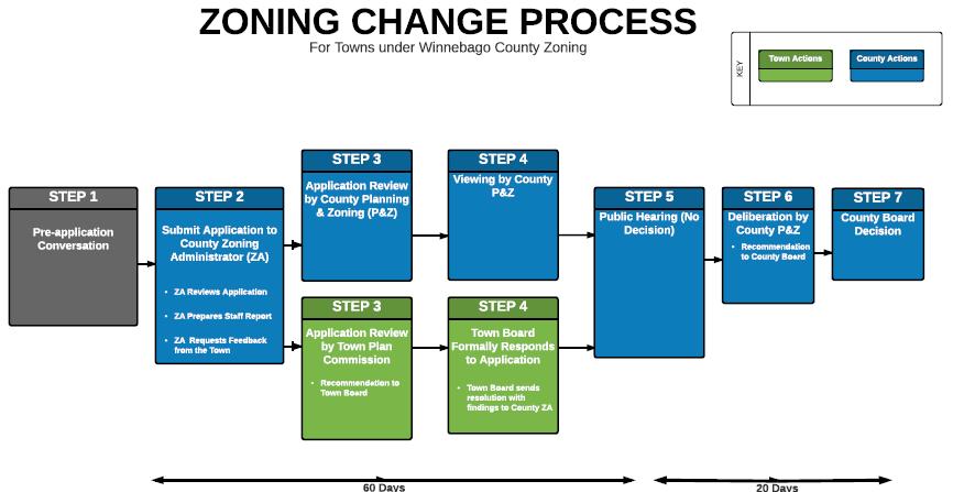
44 Petition for ordinance amendment Veto Authority for towns under county zoning Notice of public hearing & notice to affected towns Public hearing on map and/or text amendment Zoning committee recommendation to county board Governing body vote to modify, adopt or deny Amendment goes into effect and is published Within 10 days of public hearing: Towns may object to changes outside shoreland/floodplain areas. If town disapproves, zoning committee must revise proposal or recommend denial. Within 40 days of county vote: If majority of affected towns disapprove, amendment does not take effect.
45 Recommendations
46
47 Homework 1. Review application forms Do they prompt applicant to prove they meet the standards? 2. Review town recommendation forms Do they prompt towns to address the standards? 3. Review county decision forms Do they prompt decision-makers to follow the standards?


48 Land Division and Subdivision Ordinances
49 Is a subdivision plat required? Scenario 1 Jack and Jill propose creating 5 lots that are each 1.5 acres in size. 160 acre parcel YES!


50 State Subdivision Law State provides minimum standards for subdivisions (Wis. Stat. ch. 236) Subdivision = creation of 5 or more parcels of 1½ acre or less within a 5 year period State reviews for surveying, layout, mapping and plat submittal requirements
 Most restrictive provision applies Terminology: State subdivision/plat County subdivision/plat Minor")
51 Local Land Division Authority Counties, towns, cities, villages may also adopt local ordinances (Wis. Stat ) Most restrictive provision applies Terminology: State subdivision/plat County subdivision/plat Minor subdivision/csm
52 Objecting Authorities The following agencies have authority to object to state-defined subdivision plats: WI Department of Administration all state-defined subdivisions are reviewed for compliance with surveying, layout, mapping and plat submittal requirements. (Wis. Stat. 236) WI Department of Transportation subdivisions that abut a state trunk or connecting highway are reviewed for public safety issues and preservation of public interests/investments. (Trans 233) County Planning Agency 18 counties review plats located in cities/villages for conflicts with parks, highways, airports, schools, and other planned public developments. (Wis. Stat (2)(b))
53 Approving Authorities The following units of government have authority to approve of state-defined subdivision plats: County Planning Agency if the subdivision is located in an unincorporated area of the county Town Board if the subdivision is located in the town or an area whose annexation is being contested by the town City Council/Village Board if the subdivision is located in a city/village or its extraterritorial plat review jurisdiction
54 Who has plat review authority? Scenario 1 revisited The subdivision is located in a town approximately 1 mile from the nearest village. The county has a subdivision ordinance. 160 acre parcel The town and village do not. Answer: state, county and town
55 Extraterritorial Plat Review The extraterritorial plat approval jurisdiction extends: 3 miles from a first, second, or third class city 1.5 miles from a fourth class city or village Overlapping jurisdiction divided at an equidistant point The city or village must have an adopted subdivision ordinance or official map to exercise this authority It may not require public improvements or deny approval on the basis of use (Extraterritorial Zoning)
56 Is a subdivision plat required? Scenario 2 Jack and Jill propose creating 25 lots ranging in size from 5-10 acres. 160 acre parcel
57 Is a subdivision plat required? It depends on local regulations No. parcels Parcel size Time State 5 or more 1.5 acres or less 5 years Winnebago Co. 5 or more 5 acres or less 5 years Dodge Co. 5 or more Any size 5 years Fond du Lac Co. 5 or more Any size 5 years No Maybe Yes Yes

58 Local Plat Review Options The county asks Jack and Jill to meet informally with staff prior to submitting a final plat. They do not require a preliminary plat. Is this allowed? Yes
59 Local Plat Review Options 1. Pre-Application Conference Informal review intended to spot problems upfront If requested/required by local ordinance 2. Preliminary Plat Approval If required by local ordinance OR submitted by applicant 3. Final Plat Approval (minimum requirement) Submission of detailed engineering and design drawings that meet requirements of Ch. 236 Final plat entitled to approval if it complies with local plans/ordinance, meets objections of state agencies, and substantially conforms with an approved preliminary plat


60

61 Preliminary Plat drawn to scale including location of streets, utility lines, parks, storm drainage, sewer and water lines, etc.

62 Final Plat including subdivision name, legal description, street names, boundaries, measurements and other engineering data. Must follow accepted printing, layout and binding standards. Accompanied by: Surveyor s certificate of compliance, Owner s certificate of dedication, Consent of mortgagee, Certificate of taxes paid, Description of easements, and Local government approvals.
 Provision of public improvements (street lights, curb and gutter, etc.")
 Preservation of natural features (steep slopes, shorelands, wetlands, forests, etc.")
63 What can you review for? Layout, access and safety (sight lines, turning radius, emergency vehicle access, etc.) Provision of public improvements (street lights, curb and gutter, etc.) Efficient use of public facilities/services (road length, proximity to existing utilities, etc.) Preservation of natural features (steep slopes, shorelands, wetlands, forests, etc.) Compatibility with adjacent uses (use, intensity, scale, etc.) 160 acre parcel
64 What can you review for? Plat approval may only be conditioned on: Compliance with local ordinances in place at time of submittal Consistency with comprehensive plan or official map Provision of public improvements or financial guarantees (contained in a town/village/city subdivision ordinance) Satisfaction of objections raised by state agencies Other requirements of Wis. Stat. Ch. 236 Short answer items contained in an adopted comprehensive plan, ordinance or official map.
65 Who does what? Subdivision plats must be referred to the plan commission for review and recommendation. The governing body may delegate preliminary or final plat approval authority to the plan commission. Final plats dedicating streets, highways or other lands must be approved by the governing body. (Wis. Stat (5) and (3))
66 Certified Survey Map Expedited process for land divisions that do not meet state or local definition of subdivision (based on number or size): Survey, monument, and map by professional land surveyor Approved certified survey map filed with county register of deeds


67 Homework Visit some sites post-development and review against approved plans How would you amend your process or standards to provide better outcomes?

68 Part II Procedures Conducting Public Meetings and Hearings Fair and Impartial Decision-Makers Making and Recording Legally Defensible Decisions
69 Public Hearing Formal proceeding designed to receive public comment Required in the case of rezones, conditional uses, adoption of plans/ordinances, etc. Not an ideal forum for communication If you desire dialogue, discussion or negotiation, schedule a public meeting first

70 Public Meeting A gathering designed to conduct public business May include period of public comment (not required) Public has right to attend and observe Can be a good forum for public participation if the right techniques are used
71 Managing Public Input Limit comments to items on agenda Discourage repetition Encourage testimony related to standards Discourage applause and demonstrations Prohibit dialogs Enforce time limits Encourage written submittals

72 Ground Rules for Interaction From: City of Green Bay, University Avenue Corridor Redevelopment Plan

73 Public Comment Structure From: City of Green Bay, University Avenue Corridor Redevelopment Plan

74 Open Meetings Wisconsin s Open Meetings Law requires: meetings are open and accessible to the public, including disabled public is provided with advanced notice of meetings closed sessions are limited to specified circumstances and procedures WISCONSIN OPEN MEETINGS LAW A COMPLIANCE GUIDE August 2010 DEPARTMENT OF JUSTICE ATTORNEY GENERAL J.B. VAN HOLLEN

 Numbers test = enough members of a body are")

75 Open Meetings 1) Purpose test = discussion, information gathering or decisionmaking on a matter within the jurisdiction of the body. 2) Numbers test = enough members of a body are present to determine the outcome of an action. Generally, one-half of members. Less than one-half if they can block a decision.


76 Open Meetings Phone conferences, letters, s or faxes between board members may constitute a meeting if the numbers and purpose tests are met. A series of phone calls or conversations to line up votes or conduct other business violates the law. Discussion of meeting scheduling and logistics is OK.


77 Closed Sessions Closed sessions are limited by statute: Deliberations concerning a judicial or quasi judicial case with opposing parties Legal consultation for current/likely litigation Deliberations regarding property acquisition and other bargaining issues Personnel matters including employee performance, compensation, discipline, etc. Damaging personal information Others listed at Wisc. Stat
78 Conduct of Closed Sessions Record individual votes to convene in closed session Those who vote against may participate without liability Attendance limited to body, parent body, and those essential to closed session (ex. legal counsel) Consider only matters for which session is closed Motions and decisions must be recorded
 Public")

79 Notice Requirements Public Meeting Notice At least 24 hours prior (2 hours for good cause) Paid, published notice not required Post in 3 locations OR post on government website and 1 physical location (2015 WI Act 79) Public Hearing Notice 1 newspaper publication at least 30 days prior to comprehensive plan adoption or amendment 2 consecutive newspaper publications in 2 weeks prior to ordinance adoption or amendment Other decisions as specified by ordinance
 A local official cannot use a public position for the private benefit or financial gain of: the individual immediate family")
80 Conflicts of Interest Statutory Conflicts of Interest (Wis. Stat. s and s ) A local official cannot use a public position for the private benefit or financial gain of: the individual immediate family members organizations they are associated with
81 Procedural Requirements All officials must comply with the Open Meetings Law and avoid statutory Conflicts of Interest. Discretion Legislative policies, plans ordinances, amendments Impartial decision-makers may not prejudge or exhibit bias. Use professional judgment to apply ordinance standards. Record your rationale. Quasi-judicial variances conditional uses plat review Administrative permitted uses
82 Impartial Decision-Makers Bias of Local Officials (Keen v. Dane County, 2004 WI App 26) Payne & Dolan applied for a conditional use permit (CUP) for a gravel pit CUP was granted over the protests of neighbors Neighbors appealed
83 Impartial Decision-Makers Biased?? Decision maker #1 A letter was submitted as part of the CUP application stating: Payne and Dolan has always stood out above the rest in their efforts and success in being a good corporate citizen and caretaker of the land. Decision maker #2 Advocate Risk of bias too high Prior, independent business transaction Had leased his land to Payne and Dolan for the operation of a gravel pit.
 must not harbor bias, or an impermissibly high risk of bias, or prejudge the application Keen v.")
84 Impartial Decision-Makers Local officials deciding on quasi-judicial matters (i.e. conditional use, variance, etc.) must not harbor bias, or an impermissibly high risk of bias, or prejudge the application Keen v. Dane County, 2004 WI App 26
85 Impartial Decision-Makers Recuse yourself from decisions that present a conflict of interest or bias (or appearance of bias) Not the same as abstaining (not voting) Do not participate in decision or discussion leading up to decision Physically separate yourself from the decisionmaking body if possible If you want to provide testimony, do so as a member of the audience
86 Impartial Decision-Makers Ex-parte Communication = discussion regarding a pending matter not included in the public record. Quasi-judicial decision-makers should avoid it, disclose it, and encourage citizens to make important information part of the public record.

87 Recording Decisions Back to the gravel pit case in Dane County Local ordinance listed 10 factors to consider when deciding a CUP Purposes of zoning district Availability of alternative locations Compatibility with existing or permitted use on adjacent lands Keen v. Dane County, 2004 WI App 26
88 Recording Decisions After a very lengthy discussion the CUP was granted with 61 conditions But the decision did not refer to the 10 factors in the ordinance A record without any reference to the factors in the ordinance is not sufficient Keen v. Dane County, 2004 WI App 26

89 Recording Decisions Lamar applied for a variance to raise a billboard above the City s max sign height BOA denied variance stating that the variance criteria were not met Lamar Central Outdoor v. Board of Zoning Appeals of the City of Milwaukee, 2005 Wisconsin Supreme Court
90 Recording Decisions Decision-makers must express, on the record: 1. the statutory or ordinance criteria under which the application is decided and 2. the reasons the criteria are or are not satisfied The reasons do not need to appear in a written decision but should appear somewhere in the public record (meeting minutes, transcript, recording, etc.) If appealed, a judge will review the record and needs to be able to follow your reasoning
91 Recording Decisions Which motion would you prefer? 1. I move we recommend denial. 2. I move we recommend denial because the petitioner did not meet the standards. 3. I move we recommend denial because this guy isn t from here and we don t know him. 4. I move we recommend denial because the petitioner failed to show increased traffic will not create a pedestrian hazard.
92 Legally Defensible Decisions Courts defer to local decision makers when these tests are met: 1) Subject matter jurisdiction Did the body decide a matter that it is empowered by statute or ordinance to act on? 2) Proper procedures Did the body follow proper procedures (open meeting law, public notice, hearing, record of decision, etc.)? 3) Proper standards Did the body apply proper standards in making the decision? (refer to standards for rezonings, CUPs, plat review) 4) Rational basis for the decision Could a reasonable person have reached this conclusion? 5) Evidence in the record Do facts in the record of the proceedings support the decision?
93 Recommended Resources Sample guides, checklists and forms in handbook

94 Recommended Resource Plan Commission Handbook (CLUE, 2012) I. Introduction to the Plan Commission II. Procedural Responsibilities III. Community Planning IV. Public Participation V. Plan Implementation V. Ordinance Administration VI. Zoning Regulations VII. Subdivision Regulations Includes forms, worksheets, glossaries and recommended resources


95 Thank You! Rebecca Roberts Center for Land Use Education
Workshop for Local Planning and Zoning Officials. Rebecca Roberts Center for Land Use Education UW Stevens Point/Extension
 Workshop for Local Planning and Zoning Officials Rebecca Roberts Center for Land Use Education UW Stevens Point/Extension Roles and Governing Body Responsibilities Staff Boards/Committees Land Use Tools
Zoning and Subdivision Regulations. Rebecca Roberts Center for Land Use Education UW Stevens Point/Extension
 Zoning and Subdivision Regulations Rebecca Roberts Center for Land Use Education UW Stevens Point/Extension Land Use Tools Comprehensive Plan describes the future vision of the community and how to achieve
Plan Commission Workshop. Rebecca Roberts Center for Land Use Education UW Stevens Point/Extension
 Plan Commission Workshop Rebecca Roberts Center for Land Use Education UW Stevens Point/Extension Tonight s Presentation Role of Local Officials Land Use Decision Making Procedural Responsibilities Roles
Town-County Relationships in Zoning. Rebecca Roberts Center for Land Use Education UW-Stevens Point/Extension
 Town-County Relationships in Zoning Rebecca Roberts Center for Land Use Education UW-Stevens Point/Extension Tonight s Agenda Zoning basics Town role in county zoning decisions Responsibilities involved
Chapter 8 INTRODUCTION.2. STATE SUBDIVISION REGULATIONS 2 State Review (Objecting Authorities) Local Review (Approving Authorities) Basis for Approval
 Local Review (Approving Authorities) Basis for Approval") INTRODUCTION.2 STATE SUBDIVISION REGULATIONS 2 State Review (Objecting Authorities) Local Review (Approving Authorities) Basis for Approval LOCAL LAND DIVISION REGULATIONS 6 General Organization of a Subdivision
INTRODUCTION.2 STATE SUBDIVISION REGULATIONS 2 State Review (Objecting Authorities) Local Review (Approving Authorities) Basis for Approval LOCAL LAND DIVISION REGULATIONS 6 General Organization of a Subdivision
Town zoning: A good option for your town?
 Photo credit: Landslides Aerial Photography Town zoning: A good option for your town? Lynn Markham Town of Auburn May 27, 2015 Main points 1. Zoning is one tool to implement community plans 2. What does
Local Government and Industrial Sand Mining. Wisconsin has no known petroleum deposits, but the state has lots of sand and the right kind of sand.
 Local Government and Industrial Sand Mining Wisconsin has no known petroleum deposits, but the state has lots of sand and the right kind of sand. Sandstone formations DNR data: http://dnr.wi.gov/topic/mines/ismmap.html
Dane County Land Use Handbook
 Dane County Land Use Handbook Dane County Board of Supervisors Prepared by The Office of the County Board Last revision 4/6/98 Summary September 15, 1997 Dane County has land area of 1,202 square miles,
Burnett County, WI LAND USE VARIANCE APPLICATION, EXPLANATION, & REQUIREMENTS
 Burnett County, WI LAND USE VARIANCE APPLICATION, EXPLANATION, & REQUIREMENTS A variance is a relaxation of a standard in a land use ordinance. Variances are decided by the Board of Adjustment/Appeals
The Basics of Boundary Agreements. May 29, 1997
 The Basics of Boundary Agreements May 29, 1997 Wisconsin Statutes provide structures for cooperative action between municipalities including general agreements, cooperative plans, and municipal revenue
FACT SHEET. The Town Plan Commission
 Page 1 FACT SHEET Number 16 The Town Plan Commission Revised March 2001 This Fact Sheet addresses the following major topics: Why Establish a Town Plan Commission? What is the Relationship Between the
A Guide to the Municipal Planning Process in Saskatchewan
 A Guide to the Municipal Planning Process in Saskatchewan A look at the municipal development permit and the subdivision approval process in Saskatchewan May 2008 Prepared By: Community Planning Branch
DENTON Developer's Handbook
 DENTON Developer's Handbook A guide for land development in the City of Denton Department of Development Services 2017 2 Table of Contents 1. City of Denton Development Process...5 Role of the Development
ARTICLE 1 GENERAL PROVISIONS
 ARTICLE 1 GENERAL PROVISIONS SECTION 100 TITLE This Ordinance shall be known and cited as the "Rice Township Subdivision and Land Development Ordinance." SECTION 101 AUTHORITY Rice Township is empowered
2/22/2016. Planning and Zoning. David Owens March 2016 SOME CONTEXT
 Planning and Zoning David Owens March 2016 SOME CONTEXT 1 N.C. Population 1900 1.6 million 1950 2.4 million 2015 10 million 2 3 Population Growth Housing Units/ Square Mile Source: UNC Carolina Population
From Policy to Reality
 From Policy to Reality Updated ^ Model Ordinances for Sustainable Development 2000 Environmental Quality Board 2008 Minnesota Pollution Control Agency Funded by a Minnesota Pollution Control Agency Sustainable
Village of South Elgin, IL. CHAPTER 156: Unified Development Ordinance
 Village of South Elgin, IL CHAPTER 156: Unified Development Ordinance UNIFIED DEVELOPMENT ORDINANCE (UDO) EFFECTIVE DATE: October 1, 2018 1 TABLE OF CONTENTS SECTION 156.01: TITLE AND APPLICABILITY...4
Appendix C SUMMARY OF LAND USE-RELATED EXTRATERRITORIAL AUTHORITIES
 #235120-2 NMA/RMB 3/13/17 Appendix C SUMMARY OF LAND USE-RELATED EXTRATERRITORIAL AUTHORITIES Introduction Cities and villages in Wisconsin have several types of extraterritorial authority that may affect
MIDWAY CITY Municipal Code
 MIDWAY CITY Municipal Code TITLE 9 ANNEXATION CHAPTER 9.01 PURPOSE CHAPTER 9.02 GENERAL REQUIREMENTS CHAPTER 9.03 PROPERTY OWNER INITIATION OF ANNEXATION CHAPTER 9.04 PROCEDURES FOR CONSIDERATION OF PETITION
APPLICATION FOR CONDITIONAL USE PERMIT
 Receipt No. Fee Date Date Permit Issued: Certificate of Compliance: Date DOOR COUNTY LAND USE SERVICES 421 Nebraska Street Door County Government Center Sturgeon Bay, Wisconsin 54235 (920) 746-2323 - FAX
Discretion Associated with Zoning Decisions
 12 Chapter Discretion Associated with Zoning Decisions Zoning decisions are typically divided into three categories (administrative, quasi-judicial and legislative) depending on the type of decision made
Burnett County, WI SUBDIVISION VARIANCE APPLICATION, EXPLANATION, & REQUIREMENTS PROCESS (NOTE: PLEASE READ ENTIRE APPLICATION BEFORE PROCEEDING)
") Burnett County, WI SUBDIVISION VARIANCE APPLICATION, EXPLANATION, & REQUIREMENTS A variance is a relaxation of a standard in a land use ordinance. Subdivision variances are decided by the Land Use and
Burnett County, WI SUBDIVISION VARIANCE APPLICATION, EXPLANATION, & REQUIREMENTS A variance is a relaxation of a standard in a land use ordinance. Subdivision variances are decided by the Land Use and
Town of Norwich, Vermont SUBDIVISION REGULATIONS
 Town of Norwich, Vermont SUBDIVISION REGULATIONS Adopted: August 6, 2002 Amended: February 8, 2006 Prepared by Norwich Planning Commission with the assistance of: Burnt Rock Inc. A ssociates in Community
Castle Danger Subordinate Service District Phase I Land Use Ordinance #1
 Castle Danger Subordinate Service District Phase I Land Use Ordinance #1 Effective February 2, 2010 Castle Danger Subordinate Service District Phase I Land Use Ordinance SECTION I PURPOSE The purpose of
THE COUNTY BOARD OF SUPERVISORS OF THE COUNTY OF DOUGLAS DOES ORDAIN AS FOLLOWS:
 8.1 SUBDIVISION CONTROL ORDINANCE THE COUNTY BOARD OF SUPERVISORS OF THE COUNTY OF DOUGLAS DOES ORDAIN AS FOLLOWS: SECTION I. GENERAL INTERPRETATION This ordinance shall not repeal, impair or modify private
Dane County Planning & Development Land Division Review
 Dane County Planning & Development Land Division Review Date: June 26, 2012 To: Zoning & Land Regulation Committee From: Daniel Everson, Land Division Review Re: Revere Trails (preliminary plat) Town of
Article 6: Planned Unit Developments
 LUDC 2013 GARFIELD COUNTY, COLORADO Article 6: Planned Unit Developments ARTICLE 6 PLANNED UNIT DEVELOPMENTS TABLE OF CONTENTS DIVISION 1. GENERAL.... 1 6-101. GENERAL PROVISIONS.... 1 A. Purpose....
Draft Model Access Management Overlay Ordinance
 Draft Model Access Management Overlay Ordinance This model was developed using the City of Hutchinson and the Trunk Highway 7 corridor. The basic provisions of this model may be adopted by any jurisdiction
Stem Zoning Ordinance
 Stem Zoning Ordinance Town of Stem North Carolina September 21, 2016 (Supersedes Stem Zoning Ordinance 04/21/2014) ZoningORD_Final_09-21-16.docx Authority Article 1. General and Legal Provisions... 9
Town of Onalaska. A scale map depicting the portion of Pineview Drive to be officially laid out as a Town highway is attached hereto as Exhibit A.
 Town of Onalaska Special Meeting Minutes for March 31, 2011 The Town Board met on site of the Pineview Road and County OT in Onalaska for the purpose of viewing the lay out of the road as required by law.
A GUIDE TO PROCEDURES FOR: SUBDIVISIONS & CONDOMINIUM CONVERSION
 A GUIDE TO PROCEDURES FOR: SUBDIVISIONS & CONDOMINIUM CONVERSION A GUIDE TO PROCEDURES FOR: SUBDIVISIONS (TENTATIVE MAPS) PURPOSE Definition: A subdivision is defined as the division of any improved or
ARTICLE III GENERAL PROCEDURES, MINOR PLANS AND FEE SCHEDULES
 ARTICLE III GENERAL PROCEDURES, MINOR PLANS AND FEE SCHEDULES 301. Prior to Submission a. Copies of this Ordinance shall be available on request, at cost, for the use of any person who desires information
Planning 101: Annexation and Municipal & County Zoning. Annexation Title 7, Chapter 2, Parts Required Provision of Services
 Planning 101: Annexation and Municipal & County Zoning September 9, 2013 Chris Saunders, AICP Annexation Title 7, Chapter 2, Parts 42-47 Brings new territory into the boundaries of a municipality All annexations
(c) County board of commissioners means 1 of the following, as applicable: (ii) In all other counties, 1 of the following:
 County board of commissioners means 1 of the following, as applicable: (ii) In all other counties, 1 of the following:") TOWNSHIP PLANNING Act 168 of 1959, as amended, (including 2001 amendments, 2006 amendments) AN ACT to provide for township planning; for the creation, organization, powers and duties of township planning
TOWNSHIP PLANNING Act 168 of 1959, as amended, (including 2001 amendments, 2006 amendments) AN ACT to provide for township planning; for the creation, organization, powers and duties of township planning
WHEREAS, the City of Kenosha, Wisconsin is a Wisconsin municipality with offices at nd Street, Kenosha, Wisconsin 53140; and
 2017 CITY OF KENOSHA/VILLAGE OF SOMERS/TOWN OF SOMERS/TOWN OF PARIS/COUNTY OF KENOSHA/KENOSHA WATER UTILITY/VILLAGE OF SOMERS WATER UTILITY/VILLAGE OF SOMERS SEWERAGE DISTRICT/COUNTY HIGHWAY COMMISSIONER
4.2 LAND USE INTRODUCTION
 4.2 LAND USE INTRODUCTION This section of the EIR addresses potential impacts from the Fresno County General Plan Update on land use in two general areas: land use compatibility and plan consistency. Under
Do I Need a Municipal/Land Use Attorney?
 Do I Need a Municipal/Land Use Attorney? Municipal Regulation In 1789, Benjamin Franklin famously wrote that in the world nothing can be said to be certain except death and taxes. Now, more than 200 years
Department of Planning and Development
 COUNTY OF KENOSHA Department of Planning and Development December 2012 VARIANCE APPLICATION Owner: Mailing Address: Phone Number(s): To the Kenosha County Board of Adjustment: Please take notice that the
O-I (Office-Institutional) and AG-1(Agricultural)
 and AG-1(Agricultural)") PROPERTY INFORMATION ADDRESS 3503 and 3505 Bethany Bend DISTRICT, LAND LOTS 2/1 973 and 974 OVERLAY DISTRICT State Route 9 PETITION NUMBERS EXISTING ZONING O-I (Office-Institutional) and AG-1(Agricultural)
PROPERTY INFORMATION ADDRESS 3503 and 3505 Bethany Bend DISTRICT, LAND LOTS 2/1 973 and 974 OVERLAY DISTRICT State Route 9 PETITION NUMBERS EXISTING ZONING O-I (Office-Institutional) and AG-1(Agricultural)
Certified Survey Map (CSM) Submittal Updated: 6/29/18
 Submittal Updated: 6/29/18") Certified Survey Map (CSM) Submittal Updated: 6/29/18 Town of Middleton 7555 W. Old Sauk Road Verona, WI 53593-9700 Phone: 608-833-5887 Fax: 608-833-8996 info@town.middleton.wi.us The Town of Middleton
Certified Survey Map (CSM) Submittal Updated: 6/29/18 Town of Middleton 7555 W. Old Sauk Road Verona, WI 53593-9700 Phone: 608-833-5887 Fax: 608-833-8996 info@town.middleton.wi.us The Town of Middleton
Contributing Authors:
 chapter 10 Site/Development Plan Review Contributing Authors: Jackie Turner, AICP, LEED AP and Robert Thompson, AICP - Current Authors Robert S. Cowell, Jr., AICP - Previous Author In this chapter... Introduction
TOWN OF ENNIS TITLE 11 ZONING ORDINANCE DRAFT UPDATE
 TOWN OF ENNIS TITLE 11 ZONING ORDINANCE DRAFT UPDATE FEBRUARY 6, 2018 CHAPTER 1: TITLE, PURPOSE, AUTHORITY, AND GENERAL ADMINISTRATIVE PROVISIONS The regulations, standards, and procedures contained herein
NOTICE OF STATE MANDATED FEE! Approx. = $900 per Acre to Rezone A-1 Land
 NOTICE OF STATE MANDATED FEE! Approx. = $900 per Acre to Rezone A-1 Land STATE OF WISCONSIN MANDATED FARMLAND PRESERVATION ZONE DISTRICT REZONE CONVERSION FEE Beginning January 1, 2010, the State of Wisconsin
ADMINISTRATION AND DEVELOPMENT PROCESSES
 ADMINISTRATION AND DEVELOPMENT PROCESSES Section 7.01 Administrative Agencies 7.01.1 GENERAL MEETING PROCEDURES A. Open Meetings All meetings of elected or appointed bodies under this ordinance shall be
Plans shall be drawn at a readable scale, signed, and sealed by a Florida Registered Engineer. The application package shall include:
 CHAPTER 400. SECTION 403. PERMIT TYPES AND APPLICATIONS SITE DEVELOPMENT 403.3. Preliminary Site Plans (PSP) A. Intent and Purpose PSPs are used to identify existing site conditions and demonstrate general
MAJOR RESIDENTIAL AND NONRESIDENTIAL SUBDIVISIONS
 MAJOR RESIDENTIAL AND NONRESIDENTIAL SUBDIVISIONS Final Plats The applicant shall schedule a Pre-Application meeting with Planning Staff at least seven (7) working days prior to submittal of the application.
Zoning Most Frequently Asked Questions
 Zoning Most Frequently Asked Questions Zoning is needed to achieve the following: Orderly development consistent with utility location/capacity, street network, public services; Compatible land uses in
WILLIAMSON ACT CONTRACTS GUIDELINES
 NEVADA COUNTY COMMUNITY DEVELOPMENT AGENCY PLANNING DEPARTMENT ERIC ROOD ADMINISTRATION BUILDING 950 Maidu Avenue Nevada City, California 95959-8617 Phone: (530) 265-1222 FAX : (530) 265-9851 WILLIAMSON
Walworth County Farmland Preservation Plan Update, Chapter 1 Plan Summary (Cover Document)
") Background Walworth County Farmland Preservation Plan Update, 2012 Chapter 1 Plan Summary (Cover Document) For over 30-years, the Wisconsin Farmland Preservation Program has served to preserve Walworth
Background Walworth County Farmland Preservation Plan Update, 2012 Chapter 1 Plan Summary (Cover Document) For over 30-years, the Wisconsin Farmland Preservation Program has served to preserve Walworth
Subdivision of Land in Idaho. Jerry D. Mason Spring 2016
 Subdivision of Land in Idaho Jerry D. Mason Spring 2016 Subdivision Plat to Public Facilities Builds the physical environment Privately developed-publicly maintained Important environmental consequences
Exit 25 Sam Furr Road
 Exit 25 Sam Furr Road Huntersville 101: Planning Department 1. Planning Overview 2. Basic Regulatory Framework: State Statutes 3. Overview of Long Range Planning 4. Tools to Implement Long Range Plan Vision
CONDITIONAL USE PERMIT (CUP)
") CONDITIONAL USE PERMIT (CUP) LAND DEVELOPMENT APPLICATION FORM DEPARTMENT OF PLANNING 300 East Main Street, Sun Prairie, WI 53590-2227 (608)825-1107 FAX (608)825-1194 Applications will not be processed
CONDITIONAL USE PERMIT (CUP) LAND DEVELOPMENT APPLICATION FORM DEPARTMENT OF PLANNING 300 East Main Street, Sun Prairie, WI 53590-2227 (608)825-1107 FAX (608)825-1194 Applications will not be processed
13-2 SUBDIVISION PLANS AND PLATS REQUIRED EXCEPTIONS Subdivision Plats Required To be Recorded
 ARTICLE XIII SUBDIVISIONS 13-1 INTENT AND PURPOSE 13-1-1 Intent: It is the intent of the County Commission through the adoption of this Article to more fully avail itself of the power granted under 17-27-601
TULSA CITY COUNCIL PRESENTATION APRIL 22, 2010
 TULSA CITY COUNCIL PRESENTATION APRIL 22, 2010 Determining what types of uses are allowed on land Zoning is method of identifying different uses of land; categorizing and locating them in an urban environment
Medical Marijuana Special Exception Use Information
 Medical Marijuana Special Exception Use Information The Special Exception Use information below is a modified version of the Unified Development Code. It clarifies the current section 5:104 Special Exceptions
Township Planning & Zoning - A General Overview Prepared by: MAT Legal Staff Edited by: Kent Sulem, Attorney
 Minnesota Association of Townships Document Number: PZ1000 Information Library Revised: November 12, 2001 Section I: Preliminary Considerations Township Planning & Zoning - A General Overview Prepared
NOTICE OF ADOPTED CHANGE TO A COMPREHENSIVE PLAN OR LAND USE REGULATION
 NOTICE OF ADOPTED CHANGE TO A COMPREHENSIVE PLAN OR LAND USE REGULATION Date: Jurisdiction: Local file no.: DLCD file no.: May 17, 2016 City of Lebanon 16-02-09 002-16 The Department of Land Conservation
LAND USE AND ZONING OVERVIEW
 OVERVIEW OF PLANNING POLICIES LAND USE AND ZONING OVERVIEW The Minneapolis Plan for Sustainable Growth and Other Adopted Plans Community Planning and Economic Development Development Services Division
HOMER TOWNSHIP PLANNING COMMISSION LAND USE APPLICATION
 LAND USE APPLICATION 1-APPLICATION FOR: (check all that apply) Site plan Rezoning-regular PUD Special use Rezoning-spot Subdivision Rezoning-conditional 2-APPLICANT/PARCEL INFORMATION - Applicant is property
Amendment to the Zoning and Subdivision Ordinances; Consider Repeal Cluster Development Standards
 2 Board of Supervisors Meg Bohmke, Chairman Gary F. Snellings, Vice Chairman Jack R. Cavalier Thomas C. Coen L. Mark Dudenhefer Wendy E. Maurer Cindy C. Shelton February 28, 2018 Thomas C. Foley County
TOWN OF BUTNER, NORTH CAROLINA LAND DEVELOPMENT ORDINANCE
 TOWN OF BUTNER, NORTH CAROLINA LAND DEVELOPMENT ORDINANCE Adopted: September 24, 2008 Effective: October 1, 2008 As Amended Through December 7, 2017 This Page Intentionally Left Blank Table of Contents
Town of Bristol Rhode Island
 Town of Bristol Rhode Island Subdivision & Development Review Regulations Adopted by the Planning Board September 27, 1995 (March 2017) Formatted: Highlight Formatted: Font: 12 pt Table of Contents TABLE
AN ORDINANCE TO AMEND SECTION OF THE RAPID CITY MUNICIPAL CODE TO ALLOW FOR ADMINISTRATIVE DISSOLUTION OF PLANNED DEVELOPMENTS
 Ordinance No. 6231 AN ORDINANCE TO AMEND SECTION 17.50.050 OF THE RAPID CITY MUNICIPAL CODE TO ALLOW FOR ADMINISTRATIVE DISSOLUTION OF PLANNED DEVELOPMENTS WHEREAS, the City of Rapid City has adopted a
Chapter 52 FARMLAND AND OPEN SPACE PRESERVATION
 Chapter 52 FARMLAND AND OPEN SPACE PRESERVATION [HISTORY: Adopted by the Town Board of the Town of Troy 10-11-1999 by Ord. No. 99-2. Amendments noted where applicable.] GENERAL REFERENCES Building construction
Planned Unit Development (PUD). Sections:
. Sections:") Chapter 19.07. Planned Unit Development (PUD). Sections: 19.07.01. Purpose. 19.07.02. PUD Definition and Design Compatibility. 19.07.03. General PUD Standards. 19.07.04. Underlying Zones. 19.07.05. Permitted
Chapter 19.07. Planned Unit Development (PUD). Sections: 19.07.01. Purpose. 19.07.02. PUD Definition and Design Compatibility. 19.07.03. General PUD Standards. 19.07.04. Underlying Zones. 19.07.05. Permitted
LEMHI COUNTY DEVELOPMENT CODE
 LEMHI COUNTY DEVELOPMENT CODE Adopted June 12, 2017 Ordinance Number 2017-1 Repealing Ordinance No. 2012-1 and subsequent amendments in its entirety. County Commissioners Ken Miner, Rick Snyder & Brett
LRC Study Committee Property Owner Protection and Rights
 LRC Study Committee Property Owner Protection and Rights March 3, 2014 Richard Ducker Adam Lovelady David Owens Outline 1. Authority for Land Use Regulation (Owens) 2. Vested Rights (Lovelady) 3. Exactions
UNOFFICIAL COPY OF HOUSE BILL 1272 A BILL ENTITLED
 UNOFFICIAL COPY OF HOUSE BILL 1272 M4 6lr0525 By: Delegates Smigiel, Kelley, Rosenberg, and Sossi Introduced and read first time: February 10, 2006 Assigned to: Environmental Matters 1 AN ACT concerning
CHAPTER 3. APPLICATION REVIEW AND DECISION
 CHAPTER 3. APPLICATION REVIEW AND DECISION 3.1 LAND USE PERMITS/DECISIONS... 1 3.1.1 General Provisions... 1 A) Land Use Permits Required... 1 B) Effect of Approval... 1 C) Zoning Information Sheet...
MAJOR RESIDENTIAL AND NONRESIDENTIAL SUBDIVISIONS
 Lawrence-Douglas County MAJOR RESIDENTIAL AND NONRESIDENTIAL SUBDIVISIONS Preliminary Plats The applicant shall schedule a Pre-Application meeting with Planning Staff at least seven (7) working days prior
EXHIBIT A. City of Corpus Christi Annexation Guidelines
 City of Corpus Christi Annexation Guidelines Purpose: The purpose of this document is to describe the City of Corpus Christi s Annexation Guidelines. The Annexation Guidelines provide the guidance and
/ Planning and Zoning Commission Staff Report Jay Walker- All Terra Consulting - RZ
 / Planning and Zoning Commission Staff Report Jay Walker- All Terra Consulting - Hearing Date: January 17, 2019 Development Services Department Applicant: Jay Walker All Terra Consulting Staff: Jennifer
TOWN OF ROXBURY PLANNING BOARD
 UPDATED: APRIL 2011 TOWN OF ROXBURY PLANNING BOARD Applicant s Guide for Subdivision Review The Town Planning Board administers the subdivision review process. This guide has been prepared in order to
HOW TO APPLY FOR A USE PERMIT
 HOW TO APPLY FOR A USE PERMIT MENDOCINO COUNTY PLANNING AND BUILDING SERVICES What is the purpose of a use permit? Throughout the County, people use their properties in many different ways. They build
ZONING & LAND USE APPLICATION
 City of Maple Plain 5050 Independence St P.O. Box 97 Maple Plain, MN 55359 Office: (763) 479-0515 Fax: (763) 479-0519 ZONING & LAND USE APPLICATION APPLICANT INFORMATION Applicant Name Company, if applicable
ZONING ORDINANCE Ordinance No January 2011
 ZONING ORDINANCE Ordinance No. 121410 January 2011 McCordsville, Indiana Table of Contents Article I. General Provisions... 7 Section 1.01 Title... 7 Section 1.02 Purpose & Authority... 7 Section 1.03
Public Participation Zoning Code Amendment OV Planning and Zoning Commission Draft December 1, 2015 Attachment 1 Additions are shown in ALL CAP
 Public Participation Zoning Code Amendment OV1501056 Planning and Zoning Commission Draft December 1, 2015 Attachment 1 Additions are shown in ALL CAPS font, deletions shown in strikethrough font Section
R e z o n i n g A p p l i c a t i o n S u b m i s s i o n R e q u i r e m e n t s
 H O R R Y C O U N T Y P L A N N I N G & Z O N I N G 1 3 0 1 2 N D A V E., S U I T E 1 D - 0 9 C O N W A Y, S. C. 2 9 5 2 6 P H O N E : 8 4 3. 9 1 5. 5 3 4 0 F A X : 8 4 3. 9 1 5. 6 3 4 1 R e z o n i n
City of Boerne, Texas Incentives Policy
 City of Boerne, Texas Incentives Policy WHEREAS, upon full review and consideration of this Policy, the City Council of the City of Boerne is of the opinion that this Policy will assist in implementing
SECTION 1 INTRODUCTION TO THE PANAMA CITY BEACH COMPREHENSIVE GROWTH DEVELOPMENT PLAN
 1. PURPOSE SECTION 1 INTRODUCTION TO THE PANAMA CITY BEACH COMPREHENSIVE GROWTH DEVELOPMENT PLAN The purpose of the City of Panama City Beach's Comprehensive Growth Development Plan is to establish goals,
Midwest City, Oklahoma Code of Ordinances Chapter 38: Subdivision Regulations
 2012 Midwest City, Oklahoma Code of Ordinances Chapter 38: Subdivision Regulations Adoption Date: 8/14/2012 Table of Contents Article I. General Provisions... 5 Section 38-1. Preamble... 5 Section 38-2.
Bethel Romanian Church - Rezone, RZ
 / Planning and Zoning Staff Report Bethel Romanian Church - Rezone, RZ2018-0023 Hearing Date: November 15, 2018 Development Services Department Owners: Bethel Romanian Church, Corp. Applicant: Viorel Botos
WOODLAND AREA GENERAL PLAN URBAN DEVELOPMENT POLICY
 APPENDIX A WOODLAND AREA GENERAL PLAN URBAN DEVELOPMENT POLICY The following text indicates proposed amendments to the Woodland Area General Plan Urban Development Policy currently adopted and included
Location of Provisions in Ch. 160A and Ch. 153A in Proposed Ch. 160D
 Location of Provisions in Ch. 160A and Ch. 153A in Proposed Ch. 160D CHAPTER 160A ARTICLE 1 Definitions and Statutory Construction (most also retained in 160A/153A) CHAPTER 153A ARTICLE 1 PROPOSED CHAPTER
Nassau County Department of Planning & Economic Opportunity Nassau Place Yulee, Florida 32097
 Nassau County Department of Planning & Economic Opportunity 96161 Nassau Place Yulee, Florida 32097 APPLICATION AND INSTRUCTIONS FOR FUTURE LAND USE MAP AMENDMENT (TEN (10) ACRES OR MORE) NOTICE: Florida
Zoning Commission-Appeals
 Legal Responsibilities of Connecticut Land Use Boards Richard P. Roberts Partner, Halloran & Sage, LLP Zoning Commission-Categories of uses AS OF RIGHT Uses permitted in a particular zone Subject to certain
Richard P. Roberts Partner, Halloran & Sage, LLP. Zoning Commission-Categories of uses
 Legal Responsibilities of Connecticut Land Use Boards Richard P. Roberts Partner, Halloran & Sage, LLP Zoning Commission-Categories of uses AS OF RIGHT Uses permitted in a particular zone Subject to certain
Understanding the Conditional Use Process
 Understanding the Conditional Use Process The purpose of this document is to explain the process of applying for and obtaining a conditional use permit in the rural unincorporated towns of Dane County.
NOTICE OF MEETING AND AGENDA FOR THE PLANNING COMMISSION OF SPRINGVILLE, UTAH... JANUARY 23, 2018
 NOTICE OF MEETING AND AGENDA FOR THE PLANNING COMMISSION OF SPRINGVILLE, UTAH............................ JANUARY 23, 2018 Notice is hereby given that the Planning Commission will hold a public meeting
CHAPTER 3 PRELIMINARY PLAT
 10-3-1 10-3-3 SECTION: CHAPTER 3 PRELIMINARY PLAT 10-3-1: Consultation 10-3-2: Filing 10-3-3: Requirements 10-3-4: Approval 10-3-5: Time Limitation 10-3-6: Grading Limitation 10-3-1: CONSULTATION: Each
PURPOSE AND BACKGROUND
 To: City of Manitowoc From: Mike Slavney and Jessica Schmiedicke, planning consultants Date: November 2, 2009 Re: Extraterritorial, Annexation and Intergovernmental Policies PURPOSE AND BACKGROUND The
City of Altamonte Springs Developer s Guide
 Section 6 SUBDIVISION PLAN & PLAT REVIEW PROCESS This section contains information, applications, and checklists related to the subdivision development plan and plat review process in Altamonte Springs.
Development Guidebook 2016 TEXAS
 TEXAS Development Guidebook 2016 DISCLAIMER: This Development Guidebook is not law. For the full and complete requirements necessary for submitting development applications, please see the City of Magnolia
Organized with a "core" curriculum (the first five modules) and "electives" (the remaining modules in the program.
 and electives (the remaining modules in the program.") Introduction Sponsored by The North Carolina Chapter - American Planning Association These materials are the result of an effort by volunteer members of the North Carolina Chapter of the American Planning
Introduction Sponsored by The North Carolina Chapter - American Planning Association These materials are the result of an effort by volunteer members of the North Carolina Chapter of the American Planning
Planner Ken Jaworski. Approval of Minutes: A. Approval of the minutes of the Wednesday, July 8 th, 2015 Regular Plan Commission Meeting.
 Approved 09/09/2015 TOWN OF CLAYTON Town Plan Commission Meeting Minutes 7:00 P.M. on Wednesday, August 12 th, 2015 Town Office Meeting Room, 8348 County Road T, Larsen, WI 54947 I. Call to Order: A. Notice
ORDINANCE NO AN ORDINANCE AMENDING THE CODE OF ORDINANCES OF THE CITY OF PORT ARANSAS, TEXAS, BY ADOPTING A NEW CHAPTER
 ORDINANCE NO. 2008-09 AN ORDINANCE AMENDING THE CODE OF ORDINANCES OF THE CITY OF PORT ARANSAS, TEXAS, BY ADOPTING A NEW CHAPTER TWENTY-SIX CONCERNING IMPACT FEES FOR ROADWAY FACILITIES; INCORPORATING
Elkhart County ZONING ORDINANCE
 Elkhart County ZONING ORDINANCE ADOPTED: December 15, 2014 EFFECTIVE: February 2, 2015 LAST AMENDED: N/A If you are viewing a digital version of this Zoning Ordinance, you may click on any cross-reference
GOALS, OBJECTIVES, AND STRATEGIES
 GOALS, OBJECTIVES, AND STRATEGIES What follows is a series of goals, recommendations and actions that reflect the themes outlined in the Mineral Springs Vision Plan (incorporated into this document as
LAND USE PROCEDURES (LUP) BYLAW NO. 1235, 2007
 BYLAW NO. 1235, 2007") TOWN OF OSOYOOS LAND USE PROCEDURES (LUP) BYLAW NO. 1235, 2007 Adopted August 13, 2007 PART 1 PART 2 PART 3 PART 4 PART 5 PART 6 PART 7 PART 8 TABLE OF CONTENTS Index provided for ease of use and was not
TOWN OF OSOYOOS LAND USE PROCEDURES (LUP) BYLAW NO. 1235, 2007 Adopted August 13, 2007 PART 1 PART 2 PART 3 PART 4 PART 5 PART 6 PART 7 PART 8 TABLE OF CONTENTS Index provided for ease of use and was not
GOVERNMENT CODE - GOV
 GOVERNMENT CODE - GOV TITLE 7. PLANNING AND LAND USE [65000 66499.58] ( Heading of Title 7 amended by Stats. 1974, Ch. 1536. ) DIVISION 2. SUBDIVISIONS [66410 66499.38] ( Division 2 added by Stats. 1974,