City of Newnan PLANNING COMMISSION
|
|
|
- Agnes Gregory
- 5 years ago
- Views:
Transcription

1 City of Newnan Georgia Planning Commission Agenda Book July 10, 2018
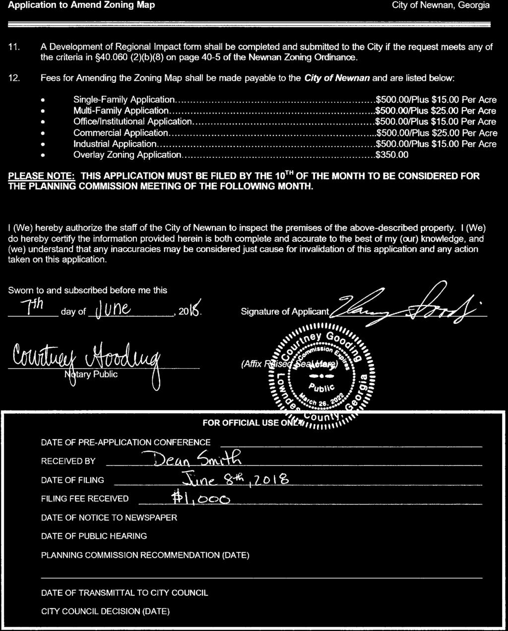
2 City of Newnan PLANNING COMMISSION Agenda for July 10, 2018 Regular Planning Commission Meeting 7:00 PM, Richard A. Bolin Council Chambers, City Hall TAB NUMBER TAB # 1 TAB # 2 TAB # 3 TAB # 4 TAB # 5 AGENDA CATEGORY / ITEM Convene Minutes of the June 12, 2018 Planning Commission Meeting Certificate of Appropriateness 89 Temple Avenue: Kenneth Parker Master Sign Plan At Home 361 Newnan Crossing Bypass: AGI Public Hearing Rezoning Request 30.8+/- acres on Newnan Crossing Bypass (Tax Parcel # ): Melissa Griffis, on behalf of Continental 449 Fund, LLC (RZ ) Public Hearing Rezoning Request /- acres on Greison Trail (Tax Parcel #N57-005): Thompson Gooding, on behalf of Oracle Consulting Services, LLC (RZ ) Public Comments Adjourn Unless otherwise posted, all Planning Commission Meetings Are held in the: Richard A. Bolin Council Chambers, City Hall 25 LaGrange Street, Newnan, Georgia Any questions prior to the meeting should be directed to the Planning and Zoning Department. Phone: tdunnavant@cityofnewnan.org

3 Planning Commission Meeting 06/12/2018 CITY OF NEWNAN Planning Commission Meeting Minutes June 12, :00 p.m. Commissioners in Attendance: Greg Gause Proctor Smith Fred Hamlin Clay McEntire Chris Hunt David Van Drew Robert Coggin Commissioners Absent: Others in Attendance: Tracy Dunnavant, Planning & Zoning Director Chris Cole, Planner Tina Fronebarger, Administrative Assistant Brad Sears, City Attorney CALL TO ORDER Chairman Gause called the meeting to order at 7:00 p.m. in the Richard A. Bolin Council Chambers, City Hall. Chairman Gause stated the Rezoning Request on Mary Freeman Road has been withdrawn. READING OF MINUTES Chairman Gause asked if everyone reviewed the minutes from the May 8, 2018 meeting. Commissioner Smith motioned to approve the minutes. Commissioner Coggin seconded the motion. MOTION CARRIED (7-0) Public Hearing Rezoning Request /- acres located on Powell, Greenville and LaGrange streets by Melissa Griffis on behalf of Cornerstone Commercial Contractors, Inc. (RZ ) Chairman Gause opened a public hearing regarding the rezoning request and mentioned that each side will have 15 minutes to speak. He asked anyone wishing to speak in favor of the request to come forward. Melissa Griffis came forward with Rosenzweig, Jones, & Griffis stating she was here with Tommy Sweet of Cornerstone and Sherry Hearn, the engineer. She stated she wanted to make sure that all of the application materials including the proffered conditions are provided, along with all of the pictures and documents in the packet that you all received. Griffis explained the subject property is acres, is located on Powell, LaGrange and Greenville streets, and is zoned RU-I and CUN. Griffis stated the request is to rezone the entire piece to RU-I with conditions to allow for a fee simple townhome development with approximately 35 units. She would like Mr. Sweet to go through the details and answer any questions. Page 1 of 5
4 Page 2 of 5 Planning Commission Meeting 06/12/2018 Tommy Sweet came forward stating that he lives on Alpine Drive and cares about the neighborhood and Newnan. Sweet stated he wanted to clear up the concern of the article that most have read, that most everything in there was correct except the minimum square footage. He said it stated the square footage would be a maximum of 2,000 square feet when in fact that will be the minimum. He mentioned having the townhomes priced at $315, and up with an average of the low $400, and has covered that with the arrangement of different sizes, some one-car garages, the majority with two-car garages and some having elevator shafts. Sweet stated he is currently building across from Kennesaw Mountain, 54 townhomes all with elevator shafts. He said this particular lot is made up of 7 parcels with 4 zoned CUN and 3 zoned RU-I. Sweet tried to pay attention to what is asked in that zoning having buildings pulled up to the front, parking internal, and having the buildings facing out to Powell Street. He paid attention to the grade and Powell is a narrow street and wants his entrance on Powell and provided an explanation. Sweet proffered to widen Powell Street, have on street parking giving a streetscape, and having parallel parking in front of Greenville Street Park. He mentioned the City asked him to draw the widening up to the church, which he does not own. He stated what he is proposing is the 35-unit townhomes, the parking would be internal, each would have garages. He provided information regarding parking and having architectural elements on the townhomes with a lot of brick. He provided photos for everyone to see the architectural elements. He explained in detail the levels of the townhomes, with some being 3 to 4 bedrooms and having access to the roof tops (which one would be able to view the details of Newnan from). He mentioned having the A/C units on the top and gave details of the property and layout. He discussed having covers on the doors for a theme, the different brick colors, building a base leading to the front door, and taking elements from the downtown and historic homes. Sweet mentioned one concern from the neighbors is the height. He said it doesn t have to be that tall and is willing to proffer and will limit that height to 40 feet and gave details. Sweet clicked through photos and provided information. Chairman Gause stated they re at 13.5 minutes if anyone else would like to speak in favor of this request. Ken Parker came forward stating he has lived downtown since the early 2000 s and he thinks it s a great thing based on what we see and being fortunate to have a local developer invest in downtown. He said he likes the fact that giving the current zoning of CUN, it will have residences for people to be downtown instead of commercial buildings and allows us to manage the area better. He said the alternative is that if we do get commercial development we may be able to manage the construction but it may be a tenant base and not conducive to downtown. Parker stated he thinks this is a great project. Chairman Gause stated that is all the time they have and asked for anyone wanted to speak in opposition to come forward. Candace Lund came forward stating she lives at 68 LaGrange Street and is not necessarily opposed to the development but has concerns. She had a concern with the density and feels the 35 units on 2.5 acres seems like a lot. She s concerned with the design and mentioned Sweet added elements that are a bit more historically appropriate, explained the age of the homes in the neighborhood and mentioned it looks great and is beautiful but doesn t fit the neighborhood completely. She asked Sweet to speak with the historical society on a few of the design elements. Chairman Gause asked if anyone else would like to come forward and speak in opposition. Frances Kidd came forward stating she lives at 18 Buchannan Street and is in the same predicament as she is not necessarily in opposition. She explained that she has lived in that neighborhood a long time and has a couple of concerns. She has concerns with the height and when previously speaking to Sweet, he stated the height to be just under 35 feet. Sweet stated that it was to the roof. Kidd mentioned she doesn t see that area as a barrier and mentioned the brick colors. She also mentioned her concern of the traffic in that area with the high school students and that it is just going to be a mess. Chairman Gause asked if anyone else would like to speak in opposition. Jill Watson came forward stating she lives on Buchannan Street. She is not completely opposed but has a major concern with the traffic as the street is really busy and it s hard to get out on LaGrange Street. Watson mentioned the height and wishes she could see fewer units. She said her big thing is the traffic and amount of cars. Chairman Gause asked if anyone else would like to speak in opposition. With no one coming forward, he asked if anyone would like to provide rebuttal. Griffis stated she would let the City go over the report. Chairman Gause closed the public hearing and asked the City to speak.
5 Planning Commission Meeting 06/12/2018 Dunnavant stated they are requesting 35 townhomes on the acres as they have stated and the zoning is RU-I and CUN on a portion of it. She stated they are asking for RU-I with conditions and RU-I is looked at with dimensionals and explained. Dunnavant provided background information regarding the property and the surrounding areas with a mixture of uses. She reviewed if the proposed use is suitable of the zoning and development of adjacent and nearby property; if the proposed use will adversely affect the existing use or usability of adjacent or nearby property; if there are substantial reasons why the property cannot or should not be used as currently zoned; if the proposed use cause an excessive or burdensome use of public facilities or services, including but not limited to streets, schools, water or sewer utilities, and police or fire protection with the engineering having no environmental concerns; traffic generation; the school board has requested that the developer provide advance notice of a schedule for construction and planning purposes; the proposed use compatible with the purpose and intent of the comprehensive plan; if the use will be consistent with the purpose and intent of the proposed zoning district; if the proposed use is supported by new or changing conditions not anticipated by the comprehensive plan; if the proposed use reflect a reasonable balance between the promotion of the public health, safety, morality, or general welfare and the right to unrestricted use of property; proffered conditions; and, concluded with the recommendation to approve the rezoning request, with conditions. Chairman Gause asked if there were any questions from the commissioners. Commissioner Coggin and Sweet discussed widening Powell Street to the intersection and gaining an easement from the church with Sweet explaining he is working with the church and it s a possibility in the future. Commissioner Coggin mentioned his experience with traffic while using that light, with Sweet stating the church has concerns as their main entrance is on Powell Street. Sweet said the property line is down the middle of the entrance for the cleaners and church and he plans to even the grade. Commissioner Van Drew asked if he were able to get the church, how much of that area would he be taking to get the street wider with Sweet stating four extra feet of asphalt, plus 8 feet to park, plus 5-foot sidewalks so you re talking about a streetscape there that is more than moving the curb back two feet and that Powell has utility poles that need clean-up since all of his is underground. He mentioned the church being on a half-acre and his discussion is pending the outcome of the rezoning. Chairman Gause said the church seems to be the issue and if the discussion went in his favor would the streetscape widening continue to this area with Sweet stating that was his plan with a small discussion. Chairman Gause asked why the building was turned sideways down Powell Street with Sweet giving information on the greenspace and that he is moving the front door to the sides with Powell Street becoming the front. Chairman Gause and Sweet discussed the topography along the railroad and his plans to handle that. Chairman Gause asked if they don t get to buy the Hardee s, how do you separate your property from the church and will the asphalt go to their asphalt. Sweet stated he has to build the street to the City s specs and they could drive over that and hopes it will be only at the entrance with the fence. Chairman Gause asked if there was any landscaping at separation. Commissioner Smith asked about the elevations being for one pod. Sweet said he drew that to be very detailed as it meets the townhomes ordinance on a couple things such as a 19-foot driveway requirement and the one he was trying to mimic up in Maryland didn t have the setbacks and explained the 18 inches of staggered and provided information. Commissioner Smith asked if all the others would include the roof top terraces. Sweet stated all of them and only five units will have a front entry garage and those are the ones that back up to the railroad. Commissioner Smith asked if this will come before them again when getting the Certificate of Appropriateness with Dunnavant stating yes, if Council approves. She mentioned them being in the Downtown Design Overlay and he could come back before the Planning Commission with one set of buildings asking it to be for the overall project. Commissioner Smith said he could come in with a master design and that time be more specific with the renderings and things. Sweet mentioned he would have it detailed out with the corners detail. Commissioner Smith suggested areas for subtle features to pick up on the historic tones as he doesn t think anyone wants to see you try to duplicate or fool anyone that it was built here where historic homes Page 3 of 5
6 Planning Commission Meeting 06/12/2018 were built. He said there needs to be property balance and set a tone on projects down the road as the Downtown is thriving. He said as it thrives, others will want to come and be a part of that. He said he thinks Sweet is on the right track and the scope is appropriate and anytime we change something there is an impact due to the nature of it. He said it s not only an impact of change - it s not instituting change when you have a willing participant to do all these nice things. Commissioner Smith said the option is to stay like this and have someone come along and develop the commercial tracts, putting them together and building a multilevel office building. He said this is in the right direction. Commissioner Coggin asked Sweet if he were to be successful in getting the church property does that mean you would or could widen Powell Street all the way. Sweet stated yes with sidewalks and more street parking if allowed. Commissioner Smith asked if he would continue the streetscape and design. Sweet provided information regarding his side. He mentioned the CUN with 10% open space and his is already at 14%, with planters on the roof tops. Commissioner Smith mentioned that in his presentation Sweet would stipulate the height. Sweet stated he s fine on Powell & LaGrange with 40 feet and provided reasons why. He also mentioned he would be fine with 40 feet on Greenville, Powell & LaGrange Streets. Commissioner Hamlin asked how many more units they would have if purchasing the church. Sweet stated he is working on that and the answer is what he shared with the church - that he wanted to be fair with them. He said the density would make sure that it s the same and he could compensate them which would be eight units. Dunnavant stated that tract is zoned CUN and he would have to come back before this board for rezoning that property. Commissioner Hamlin stated he really likes what he is doing and it being a great addition, but the density concerns him. He asked if he gets the church, could he spread this out a little. Sweet stated if he s trying to compensate the church, along with that people have different feelings. He discussed having infill property, looking at previous businesses, and there being environmental issues to deal with and that he doesn t know what they are as soil samples are being done, and he focused on ownership whether it s an office or house. He provided more information. Chairman Gause asked Dunnavant what were the questions regarding traffic, getting out on the street and what would be the trigger to getting a light at Powell & Buchannan. Dunnavant stated it typically looks at things engineering looks at and she could ask them as that is not something she specializes in. Chairman Gause asked if there were any other questions or comments. Commissioner Smith motioned to forward to City Council the recommendation of approval for the rezoning request for the acres located on Powell Street, Greenville Street and LaGrange Street going to a zoning of RU-I with conditions and those conditions will include the dimensional requirements included in the staff report with the one change being the applicant s proffered condition of the maximum building height of 45 feet of that being limited to 40 feet on those buildings that front Greenville, Powell & LaGrange Streets and additionally the approval would be conditioned that the project would be consistent with the preliminary site plan, elevations, landscaping, building material, and all other documents submitted with the application. Commissioner Coggin seconded the motion. Chairman Gause asked Sweet if the height was correct. Sweet stated no and that the height when you view it from LaGrange, Powell, & Greenville will be 40 feet on the front wall but he still needs the 45 feet when you come into it to get that staircase up. Commissioner Smith asked if it would relatively be 45 feet. Sweet stated it would be 40 feet limited to 45 feet and provided information. Chairman Gause said that the height of the building would top out at 45 feet and from the street would be 40 feet. Sweet stated yes. Chairman Gause stated the motion will need to be revised. Commissioner Smith said you are limited to the parapet wall to 40 feet and the roof at the elevator, stairwell be no more than 45 feet. Sweet stated yes to both. Commissioner Smith stated he would amend the motion to reflect staff s original dimensional requirements. Commissioner Coggin seconded the motion. MOTION CARRIED (7-0) Page 4 of 5
7 Planning Commission Meeting 06/12/2018 Chairman Gause asked if this would go before Council with Dunnavant stating on July 17, Dunnavant also mentioned there will be a July meeting. Adjourn With no further business, the meeting was adjourned at 7:59 p.m. on a motion from Commissioner Hunt and seconded by Commissioner Coggin. MOTION CARRIED (7-0) Chairman Gause Page 5 of 5

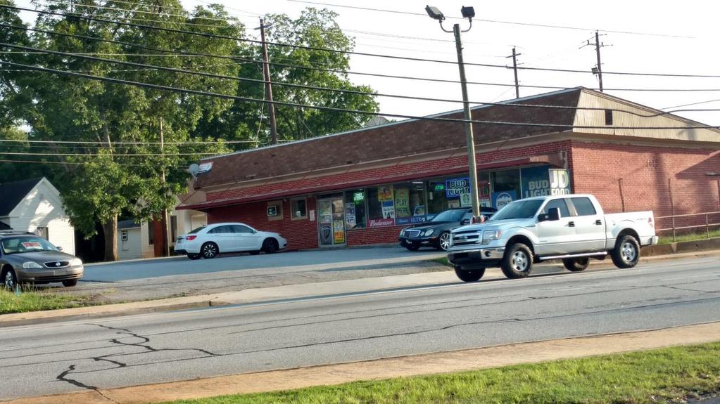
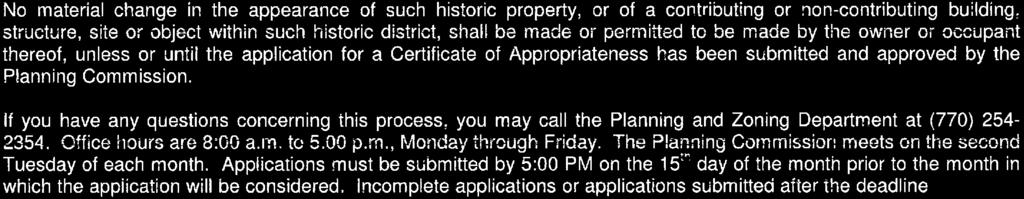
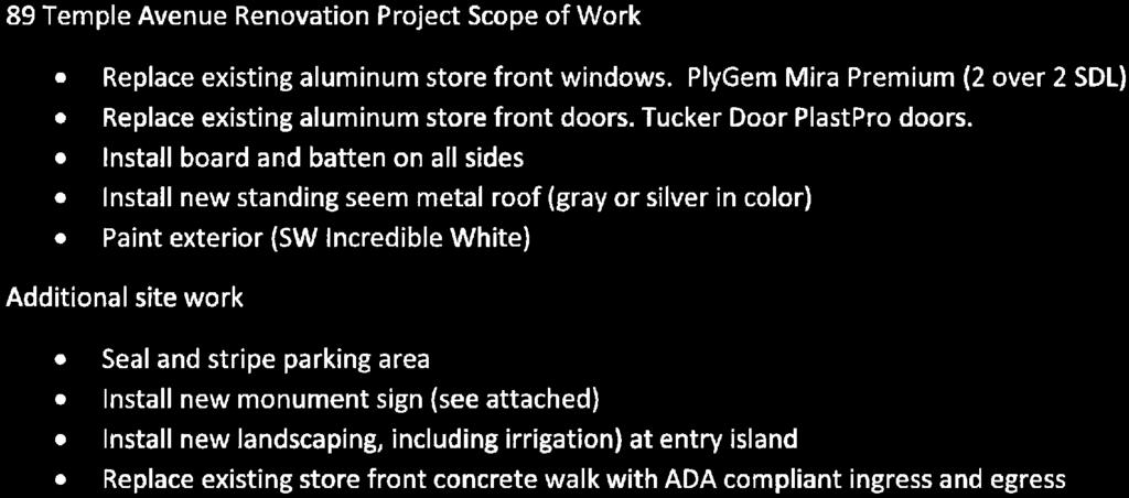
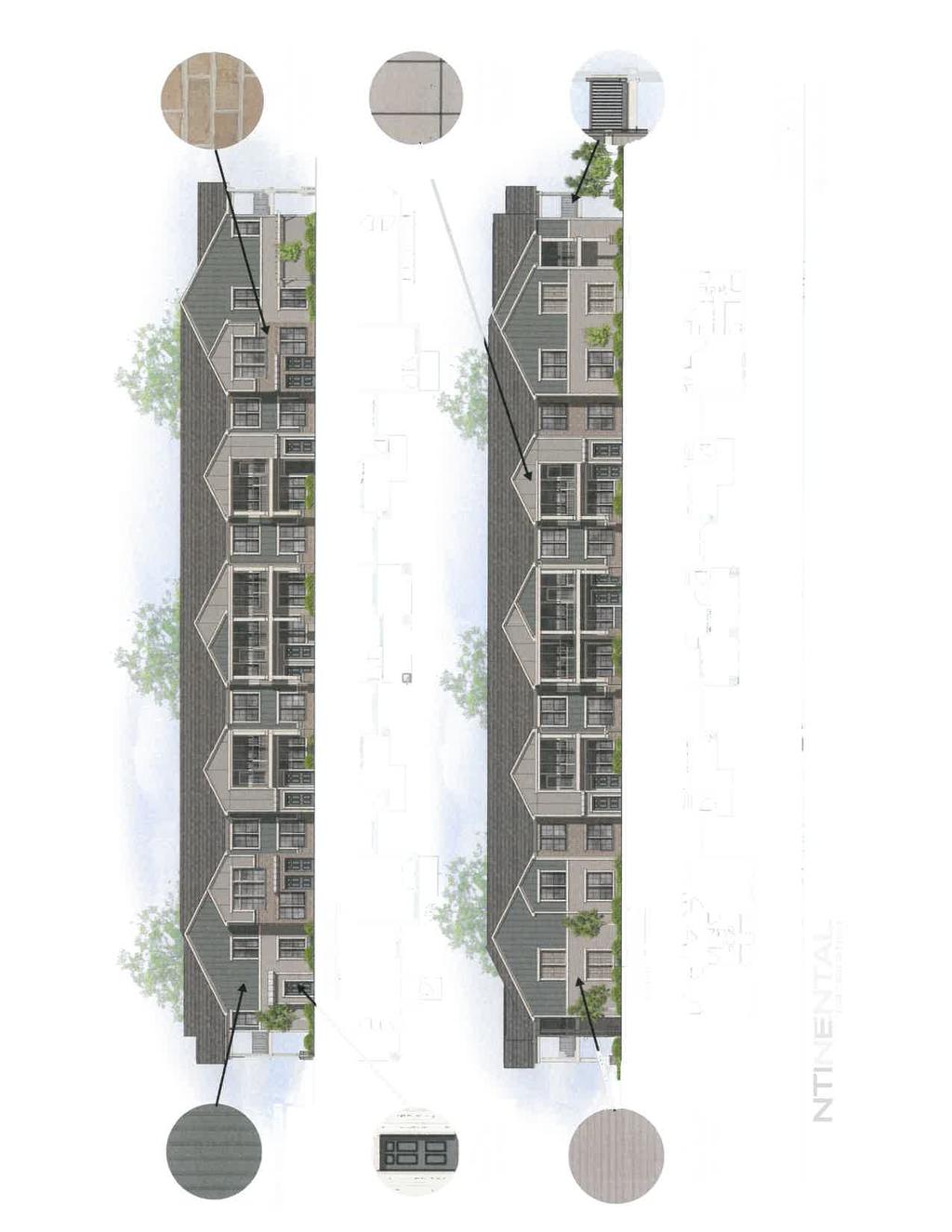
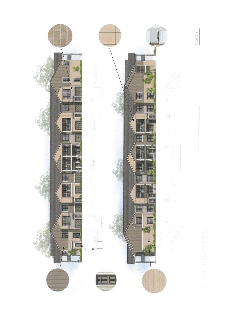
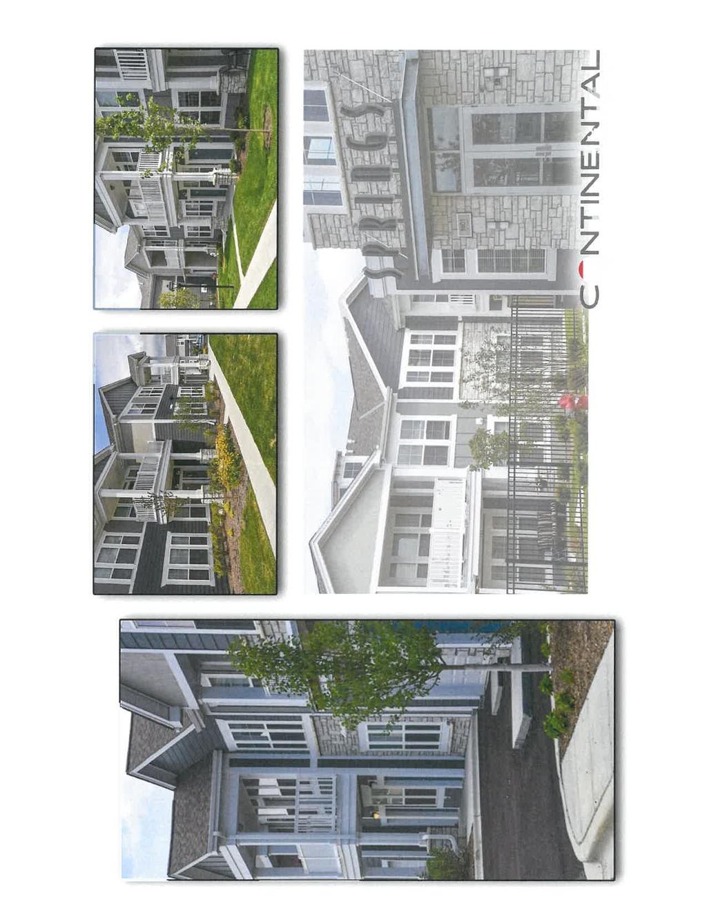
8 City of Newnan, Georgia Planning Commission Date: July 10, 2018 Agenda Item: Certificate of Appropriateness 89 Temple Avenue Prepared by: Dean Smith, Planner Purpose: This item involves a certificate of appropriateness request from Kenneth Parker regarding design changes for the existing building at 89 Temple Avenue. Background: Zoning District Proposed Land Use Current Parcel Size Urban Neighborhood Commercial District Regulations (CUN) Office/Future Retail (unspecified) /- acres Kenneth Parker has submitted an application for enhancements to the building at 89 Temple Avenue. Per the City s Zoning Ordinance, the Planning Commission must grant a certificate of appropriateness since the property lies within the Building Exterior Quality Design Corridor (BEQ) and the proposal is for improvements to exterior walls covering more than 25% of the total wall area that do not meet all BEQ requirements. Photo of structure as it exists today

9 The proposal includes upgrades to the exterior of the building. There are also planned interior improvements (that are not subject to this review). According to the application, the goal of the exterior work is to create an overall façade that will be new, bright, inviting and eye catching. Please see the attached summary from the applicant, as well as the plans and visual depictions, for a complete overview of the proposal. The properties surrounding the site include a mixture of commercial and residential uses. Concept photo used for illustrating intent of exterior renovation The Certificate of Appropriateness request is exclusive the building elevation and materials. The applicant is also proposing reducing the degree of non-conformity for the monument sign, parking lot improvements, improving the landscaping and ADA accesssibility; however, the focus of this approval is for the building itself. Options: A. Approve the certificate of appropriateness for the renovations associated with 89 Temple Avenue. B. Approve the certificate of appropriateness with conditions.
10 C. Deny the certificate of appropriateness request. Recommendation: Staff recommends Option A; approve the certificate of appropriateness request. Attachments: Certificate of Appropriateness Application, Aerial, and Building Depictions Previous Discussions with Commission: None


11 Existing Sign Proposed monument sign
12
13
14
15

16


17


18
19
20
21
22
23
24 REQUEST City of Newnan, Georgia Planning Commission Date: July 10, 2018 Agenda Item: Master Sign Plan At Home 361 Newnan Crossing Bypass Prepared and Presented by: Dean Smith, Planner AGI has submitted a request to design and install wall signs on the forthcoming remodeling/expansion project for a At Home business establishment that will be of a larger collective size than is currently allowed by the City of Newnan s Sign Regulations under the wall sign calculation method. The Master Sign Plan is a new concept that was just adopted by the City of Newnan as a part of its Zoning Ordinance revision approved by City Council in September, Sec Master Sign Plans. Master Sign Plans may be submitted by a property owner or their authorized representative for preapproval of permits for permanent signs. The Master Sign Plan must comply with the requirements of this Section. (a) Master Sign Plans shall illustrate all proposed permanent signs for which sign permits will be required under Sec. 8-7 in sufficient detail so as to provide knowledgeable review and design specificity. Master Sign Plans shall show, describe or illustrate all signs proposed to be located on a lot or within a development (and the buildings and structures related thereto). (b) For a planned center (as defined herein), the entire development must be included in the Master Sign Plan. (c) Master Sign Plans must include: (1) Location. An accurate drawing to scale showing the position of the sign or signs in relation to nearby buildings or structures (including other signs), driveways, parking areas, property and right-of-way lines, and any other limiting site features. The drawing must be drawn to site plan standards consistent with the Procedures and Permits Article, and must show or note (as applicable): a. The location and size of all other signs on the parcel that are proposed to remain; b. For freestanding signs, the distance in feet to the nearest property line or street right-of-way line, and to the nearest existing freestanding sign proposed to remain; and c. The distance in feet from the location of the nearest proposed freestanding sign(s) to the closest residentially zoned property within 500 feet. (2) Sign Structure Specifications. a. An accurate drawing to scale of the plans, specifications and method of construction and attachment of the sign or signs to the building or ground. The drawing shall specifically include the
25 size of the sign structure(s) and sign face area(s), height of the sign(s), and construction materials to be used. b. For any sign for which a building permit is required, the drawing shall be an engineered structural drawing designed to all Building Code requirements. (3) Design. a. The Master Sign Plan shall include such drawings and specifications as may be required by the Planning and Zoning Director to clearly illustrate the design elements of the sign or signs, including the construction materials, size, letter style and color of all elements of the sign(s), including the sign structure, the sign face, and background surfaces. b. The plan shall also show landscaping details meeting the requirements of this Article, including the extent of the designated landscaping area, the location of specific landscape materials, and the botanical and common name of plants by location on the plan. (d) Approval. (1) A Master Sign Plan depicting signs that conform to all requirements of this Article may be approved administratively by the Planning and Zoning Director. (2) A Master Sign Plan depicting signs that exceed or modify one or more requirements of this Article must be approved by the Planning Commission. a. Following review of a complete application by the Planning and Zoning Department, the plan will be placed on the agenda of the next available Planning Commission meeting. b. If approval is denied by the Planning Commission, the applicant may appeal within 30 calendar days of the denial to the Zoning Board of Appeals in accordance with the provisions for a hardship variance under the Appeals Article of this Zoning Ordinance. (3) Upon approval, the Master Sign Plan shall supersede any conflicting restrictions and regulations of this Article for the property to which it pertains, and shall not be adversely affected by any subsequent amendments to this Ordinance. (e) Recordation of approved Master Sign Plan. (1) The Master Sign Plan as approved must be recorded by the owner in the office of the Clerk of Superior Court and a copy of the approved Master Sign Plan, as recorded, must be filed with the Planning and Zoning Director and the Building Official prior to issuance of a sign permit for any part of the development or premises. (2) The recorded Master Sign Plan must be included in any sale, lease or other transfer of right of occupancy affecting any part of the development or premises to which the Master Sign Plan applies. (3) All tenants of the property or development, whether an owner, lessee, subtenant, purchaser or other occupant, must comply with the approved Master Sign Plan. The proposed Master Sign Plan focuses the wall signs on a single elevation of the building, namely the West side (Front of the Business). The proposal places 2 signs on the front, one sign is 231 square feet
26 and the other at 98 square feet. Under our current regulations, the business is eligible for a total of 3 wall signs at 150 sq. feet per sign with a total of 450 square feet. The total combined calculation for the front elevation is less than 450 square feet. The application also includes a proposed monument sign; however, the monument sign has been designed to be in compliance with our ordinance. The request provides a comprehensive sign plan for At Home and, if approved, they would not be able to add any more wall signs without express approval from the Planning Commission. Any changes from this plan, including any future businesses, would require re-submitting a revised Master Sign Plan to the City s Planning Commission. Options A. Approve the Master Sign Plan. B. Deny the Master Sign Plan. Recommendation Staff recommends approval of the Master Sign Plan for At Home at 361 Newnan Crossing Bypass.

27 Jimmy Fuller Project Manager June 21, 2018 Dean Smith, Planner 25 LaGrange Street Newnan, GA T x4105 C Valley View St #450 Cypress, CA Dear Mr. Smith, Enclosed is the application package for a Master Sign Program for the future at home store located at 361 Newnan Crossings Bypass. The Master Sign Program is consistent with the building architecture and design. The subject property, located approximately 660 feet from Newnan Crossings Bypass and will occupy an 88,600 sq ft retail space. This is the former Gander Mountain building. The facade on the front elevation will be 435 long at an average height of 24 (excluding house entryway). Our Master Sign Program is proposing a total of (2) wall signs for the subject property. The wall signs will both be located on the front elevation as indicated on our submittal as sign 01 & 02. Both signs are comprised of individually illuminated (LED) channel letters that vary in size. Proposed sign 01 is to be overall, 7 tall x 33 long for a total of 231 sq ft, and will be located over the front entrance on the newly built house element. Proposed sign 02 is to be 2-4 tall x 42-1 wide for a total of 98 sq ft, and will be located on the front of the building to the right (south) of the entrance. In preparing this package consideration was given to the amount of square feet proposed for the front of this building. Per code, at home is entitled to a wall sign on the side (south) elevation facing the street, however we have decided to forgo that sign and are requesting additional square feet on the front elevation. The signs proposed are in proportion to not only the house element but the overall size of the building itself. If you have any questions please feel free to contact me. Thank you, Jimmy Fuller
28 ATH-84 7' tall at home Channel Letters
29
. 5' tall sign would be allowed.")
30 Newnan, GA Jimmy Fuller Laura Kelly Scott Tarr Callaway / Axiom 01 Gander letters Remove & Replace AH-84 7' tall 'at home' channel letters 7' 33' 5" 231 Y Variance required for sq ft of sign (Max 150 sq ft). 5' tall sign would be allowed. If not approved then only a
31 Variance required for 2nd sign on front elevation (only 1 sign allowed by code). If not approved no tagline would be allowed.


32 Newnan, GA Jimmy Fuller Scott Tarr Laura Kelley Callaway / Axiom
33 114" 60" Aluminum sign cabinet w/ mounted channel letters 'at home' and push thru acrylic 'The Home Decor Superstore'. Cabinet painted to match building color Sherwin Williams 'at home Dark Grey' Concrete painted to match building color Sherwin Williams 'Jenison Grey'
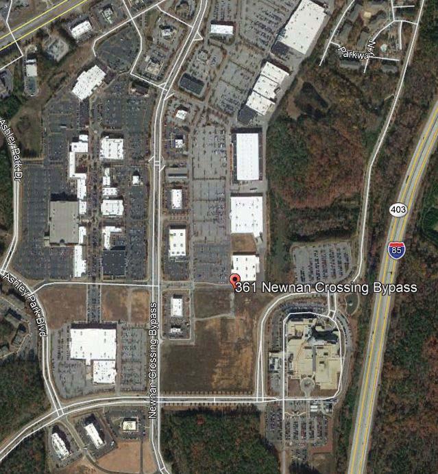
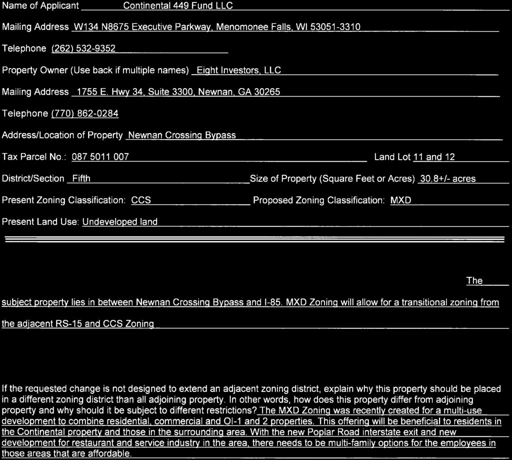
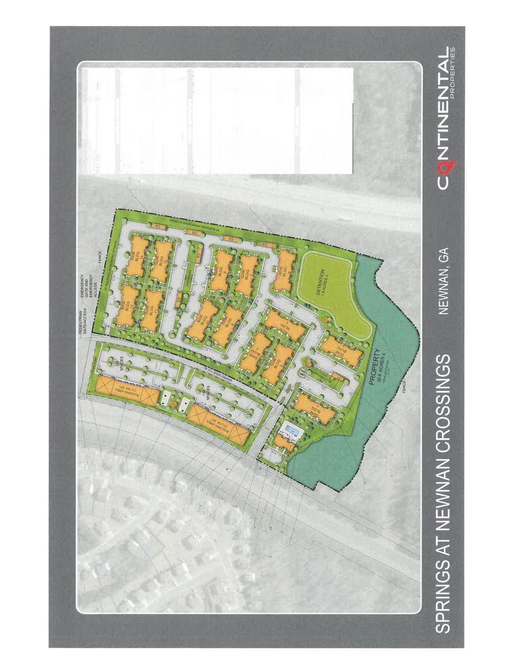
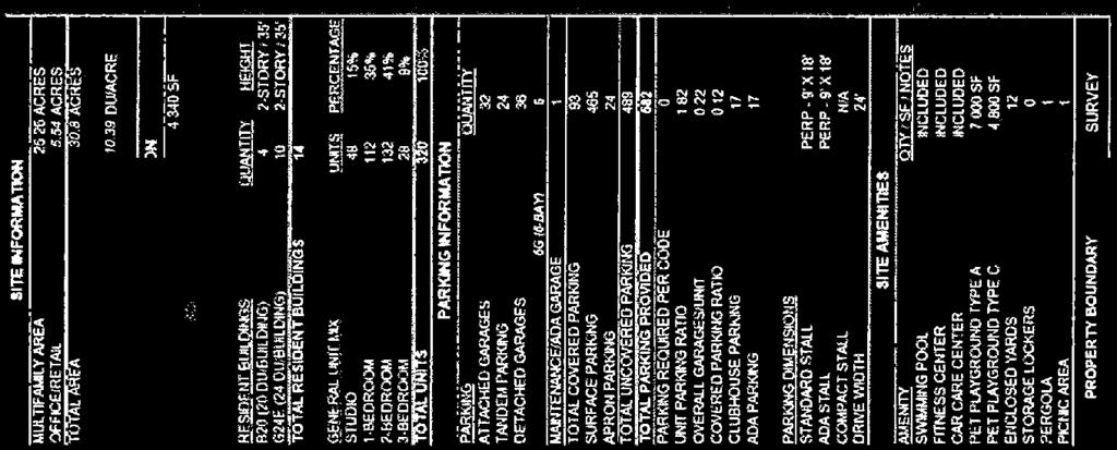
34 City of Newnan, Georgia Planning Commission Date: July 10, 2018 Agenda Item: Rezoning Request RZ ± acres on Newnan Crossing Bypass (Tax Parcel # ) Prepared and Presented by: Tracy Dunnavant, Planning Director Purpose: Melissa Griffis, on behalf of Continental 449 Fund, LLC, is seeking to change the zoning on a 30.8 ± acre tract located on Newnan Crossing Bypass (Tax Parcel # ). The applicant is seeking to develop a 320 unit apartment complex with the frontage on the bypass being reserved for uses permitted in the OI-1, OI-2, CCS and CGN zoning designations. The 30.8± acres are currently zoned CCS (Community Shopping Center District) and the applicant is seeking an MXD (Mixed Use Development District) zoning designation. Background: The subject property is currently vacant and is located between Newnan Crossing Bypass and Interstate 85 (I-85). The site is primarily surrounded by vacant land to the north and south with the aforementioned roads bordering it on the east and west. The applicant is seeking an MXD zoning to allow greater flexibility in developing an overall plan that includes a mixture of uses. In the MXD zoning designation, the land uses and development standards are presented by the applicant through a concept plan which will become part of the zoning approval if the application is successful. Present Zoning District Proposed Zoning District Current Land Use Parcel Size CCS MXD Vacant 30.8 ± acres Surrounding Zoning Classifications North East South West CCS I-85/PDR RS-15 Bypass/RS-15 Surrounding Land Use Pattern North East South Vacant Land I/85; Vacant Land and Stillwood Apartments Vacant Land Continental 449 Fund Newnan Crossing Bypass Rezoning Request
35 West Lakeshore Subdivision Summary: Staff analyzed the following criteria prior to formulating a recommendation: Is the proposed use suitable in view of the zoning and development of adjacent and nearby property? The subject property is primarily bordered by a mixture of residential and commercial designations. The tract abuts both Interstate 85 and Newnan Crossing Bypass, which is a major four lane road. Staff feels that the proposed use would be suitable as a portion of the land will retain a commercial/office use and the apartments would serve as a transition between the commercial tract to the north and the single-family residential zoned tract to the south. In addition, there is a stream along the southern end of the property that will provide additional buffering between the uses. Will the proposed use adversely affect the existing use or usability of adjacent or nearby property? In Staff s opinion, the change in zoning will have minimal effect on nearby properties. As this tract is not developed at present, there will be an increase in traffic for the Newnan Bypass area; however, it should be noted that this tract is currently zoned for commercial uses which will more than likely have a greater impact in terms of traffic once it is completely developed. In addition, all access will be on Newnan Crossing Bypass which is a four lane divided highway capable of handling the additional trips generated by the development. Are their substantial reasons why the property cannot or should not be used as currently zoned? The property is currently zoned for commercial development and Staff feels the property could be used as currently zoned. There are commercial tracts all along the Bypass and with the opening of the Poplar Road Interchange, it is anticipated that this area will see additional commercial development. Will the proposed use cause an excessive or burdensome use of public facilities or services, including but not limited to streets, schools, water or sewer utilities, and police or fire protection? For multi-family developments of more than 150 units, a community impact study must be submitted and shall include data on the aforementioned public services as well as taxes. The following reflects the results of the study as well as additional comments from the Engineering Department. A copy of the study document and all pertinent attachments has been included in this report. Engineering: Environmental Concerns: The development plan shall follow and comply fully with the Georgia Storm Water Management Manual, latest edition. Continental 449 Fund Newnan Crossing Bypass Rezoning Request
36 All streams, wetlands and other environmentally sensitive areas such as, floodplain, shall be determined and located within open space to the extent practically possible. This site in located within the water supply watershed and thus increased stream buffers apply. Perennial streams shall carry an undisturbed stream buffer of 100 feet with an additional impervious surface setback of 50 feet. Intermittent streams shall carry an undisturbed stream buffer of 50 feet with an additional 25 foot impervious surface setback. State waters buffers shall be measured from the point of wrested vegetation and shall be delineated in the field. This site is located within the Stillwood Creek Watershed Basin and is required to comply with the conditions set forth in the Stillwood Creek Watershed Drainage Ordinance. Access, Layout, and Road Concerns: ADA compliant six (6) foot sidewalks shall be provided along the public right of way adjacent to the development (not including the interstate) and 5 foot sidewalks within the development. The proposed entrance road and shared drive shown on the concept plan are to be private roads. All private roads described herein, regardless of construction standards, will be maintained in perpetuity by the applicant/owner. Trip Generation: The traffic expected to be generated by the proposed development is shown in the following table. ITE DAILY AM PEAK HOUR PM PEAK HOUR USE COD 2-WAY ENTER EXIT TOTAL ENTER EXIT TOTAL 220 E Apartment, 320 Dwelling Units Specialty Retail, 3500 SF Specialty Retail, 10,000 SF Specialty Retail, 10,000 SF Medical Offices, 20,000 SF Total Trips Internal Trips Pass By Trips New Trips to External Streets The use of the commercial space could vary. Judgment was used to estimate the expected land use based on the surrounding land use. If deemed necessary, a full traffic impact study would need to be completed in order to determine the impact to the street system. However, it is likely that the majority of trips would be destined to the north on Newnan Crossing Bypass. The intersection of Newnan Crossing Bypass and Lower Fayetteville Road currently has poor operations during the PM Peak. However, the City is currently in the process of selecting a consultant to design the widening Continental 449 Fund Newnan Crossing Bypass Rezoning Request
37 of Lower Fayetteville Road to four-lane. The intersection would be improved in this project. This development would have a minimal impact on the operation of this intersection and no impact would be expected at any other intersection. The subject property is zoned Community Shopping Center (CCS). It could be developed with that zoning, but 100% commercial use would typically generate more trips than the proposed use. School: In response to the applicant s request for input on the community impact study, Ronald Cheek, Director of Facilities for the Coweta County School System offered the following: In our experience, residents of apartment dwellings are often more transient than those in single family dwellings. This may present challenges when planning for school enrollment and meeting student needs. Due to the high density housing in the area of the proposal, school capacity is an ongoing concern. Many of the schools serving that area are at or near capacity. If approved, we would request that the developer provide us advanced notice of the following information for our planning purposes : What is the construction schedule for the project? What is the proposed build-out timeline? Will the project be built in phases? Will there be a targeted market, e.g., senior citizens? The applicant did note that an additional tax revenue of $103,129 per year would be dedicated to the school system as a result of the proposed development. They also indicated that their typical development only has 8% of residents with school age children. Police: In reviewing historical information concerning number of calls for service, response time, and number of officers, following is the impact to the police department services. The numbers are projected with 41 Officers being used to determine calls per officers. These 41 officers are patrol officers who will normally be the first responders to any call for service. Annual Calls for service Estimated Population Calls per citizen Calls per Officer Estimated occupants each new resident Calls per additional resident Additional calls per Officer Estimated time on each call Response time increase from/to 54,000 34, , hour 4.2 min to 5 min. While these numbers may appear to be low in number, it does take an officer off of the street longer than just taking information, and filing a report. We would be able to service this development, but it would require a longer response time. Newnan Utilities: Scott Tolar has indicated that Newnan Utilities does have ample water and sewer capacity to serve the proposed development. The developer will be responsible for all upgrade costs necessary to serve the property. Continental 449 Fund Newnan Crossing Bypass Rezoning Request
38 Fire: Fire Chief, Stephen Brown, has indicated that his department would be able to service the development with their existing personnel and equipment provided that adequate water supply was available. Taxes and Fees: The subject property, Parcel , currently has an assessed value of $2,132,550. The City of Newnan s current millage rate is The annual tax revenue to the City based on the current assessed value is $25, It is estimated that the fair market value of the property would increase to $40 million with the proposed improvements. The assessed valuation would be 40% of the fair market value or $16 million. The resulting annual tax revenue would be $193,760 per year (an increase of $167, per year). The following table shows the distribution of the additional tax revenue. County $42,336 School $103,129 City $22,470 TOTAL $167,935 The development of this property as proposed would require impact fees to be paid including the following: Development Impact Fee $1, per unit $363,542 Sanitary Sewer Impact Fee $1,800 per unit $576,000 Water Meter and Extension Fees Over $300,000 TOTAL IMPACT Over $1,239,542 Is the proposed use compatible with the purpose and intent of the comprehensive plan? The Future Land Use Map shows the property as future clean industrial. Clean Industrial areas provide sites for clean-based industries (as opposed to the more traditional industrial areas) and supporting, nonresidential land uses that complement industrial uses or require an industrial environment. The multi-family portion of this development would not be consistent with the comprehensive plan. Will the use be consistent with the purpose and intent of the proposed zoning district? The proposed use would be consistent with the purpose and intent of the proposed zoning as both an apartment complex and commercial/office uses would be allowed in a MXD zoning designation. Is the proposed use supported by new or changing conditions not anticipated by the comprehensive plan? As specified above, the Future Land Use map shows this property as future clean industrial. Since this designation was just assigned in October of 2017, there are no new or changing conditions that would impact the designation shown in the Comprehensive Plan. The Council was aware of the interchange project as well as the future widening of Lower Fayetteville Road. Continental 449 Fund Newnan Crossing Bypass Rezoning Request
39 Does the proposed use reflect a reasonable balance between the promotion of the public health, safety, morality, or general welfare and the right to unrestricted use of property? Staff feels the proposed use for the property does reflect a reasonable balance. The development would have less of an impact on the area than a traditional 30 acre commercial development in terms of traffic generation. In addition, Newnan Crossing Bypass should be able to handle the additional traffic with any needed road improvements being addressed by the developer. Proffered Conditions: The applicant is willing to limit the MXD zoning district uses to OI-1, OI-2, CGN, CCS and the multi-family component. In addition, the two outparcels shall be developed with the Quality Development Corridor Overlay standards and a consistent sign package will be used throughout the development. Options: A. Approve the rezoning request as submitted B. Approve the rezoning request, with conditions C. Deny the rezoning request Staff Recommendation: As with all growing municipalities, there is a need to provide housing opportunities for individuals who do not desire or cannot afford home ownership. This need increases as more retail and service providers locate within the Newnan area bringing more moderate paying jobs and as more active adults change their housing preference to a more maintenance free lifestyle. When there are few parcels left to accommodate large multi-family developments, the City sees an increase in rezoning and annexation requests to fill that need. The dilemma that arises is how to strike a balance between meeting that need and oversaturating the market. Since 2013, the City has approved around 960 new multi-family units. Eight hundred of the units are higher end apartments (Trees of Newnan and The Residences at Newnan Crossing) which will rent between $900 to $2,000 per month depending upon unit size and number of bedrooms. One hundred and sixty are more affordable apartments (Jefferson Grove Apartments) with rents based on income. Of the 960 units, 500 are currently built and the other 460 are being permitted. During that same period, the City has added 1.5 million square feet of commercial, office, and industrial space per the Building Department. With the Poplar Road interchange opening next year and the build out of the Newnan Crossing Boulevard East development, this figure will continue to increase bringing more workers looking for housing options near their jobs. After reviewing the application and the rezoning criteria, Staff feels that while there may be ample units to meet current multi-family demands, with the build out of Ashley Park, the additional development at Newnan Crossing Boulevard East, and the completion of the I-85 interchange, additional multi-family units will be needed in the future. The proximity of this proposed development to those three areas makes it an acceptable location for this type of project. In addition, there will be commercial/office space on the front that can serve the residents of the apartments as well as those currently residing in Lakeshore subdivision. In Continental 449 Fund Newnan Crossing Bypass Rezoning Request
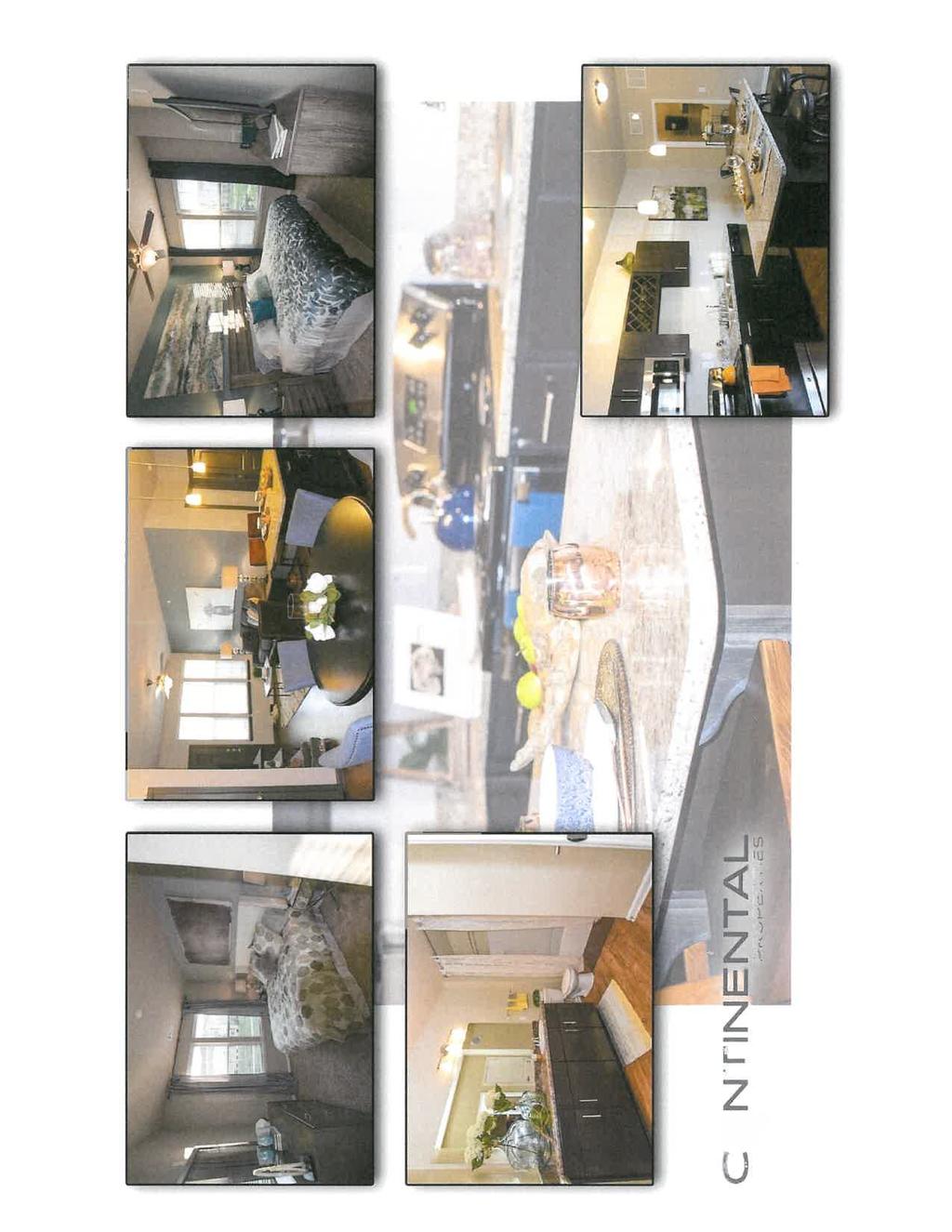
40 terms of traffic, the development would more than likely be adding less trips than the tract would generate if built out as currently zoned. The apartments would also serve as a better transition between the commercial land to the north and the single-family residential zoned property to the south. Therefore, if the Commission no longer envisions this area as future clean industrial, Staff would recommend Option B, approve the rezoning request with the following conditions: 1) The development of the property will be consistent with the concept plan, pictures, amenities and supporting documentation that has been provided as part of the rezoning application. 2) The proposed entrance road and shared drive shown on the concept plan are to be private roads. All private roads described herein, regardless of construction standards, will be maintained in perpetuity by the applicant/owner. Attachments: Application for Rezoning Community Impact Study Location Map Concept Plan Previous Discussions with Commission: None Continental 449 Fund Newnan Crossing Bypass Rezoning Request


41


42

43
44
45

46
47


48
49
50

51


52
53


54


55

56
57

58


59


60


61


62


63
64
65


66
67


68
69


70

71

72
73


74

75 Community Assessment Memo 55 Millard Farmer Ind. Blvd. Newnan, GA To: From: Tracy Dunnavant, Planning Director Vern Wilburn, P.E., PTOE Date: June 27, 2018 Re: Parcel , East Side of Newnan Crossing Bypass south of Lower Fayetteville Rd This memo outlines community impacts expected to occur from the potential rezoning of a 30 +/- acre parcel of property adjacent to Newnan Crossing Bypass from Community Shopping Center (CCS) to Mixed Use Development (MXD). The development will include a multi-family residential community on acres and a commercial development on 4.84 acres. Input was requested from various agencies and utility providers including: the Coweta County School Board, Newnan Utilities, the Newnan Police Department, and the Newnan Fire Department. Responses have been received from each of them and the responses are included in this memo. Coweta County School Board A letter was received from the Operations Director for the Coweta County School System who provided information on the expected impact. A copy of the letter from Ronnie Cheek is included in the appendix. Mr. Cheek asked for additional information about schedule and if residential would be targeted to a specific market. This information will be provided to Mr. Cheek at a later date. It is noted that an additional tax revenue of $103,129 per year would be dedicated to the school system as a result of the proposed development (see page 3). 1
76 Roads and Streets The traffic expected to be generated by the proposed development is shown in the following table. ITE DAILY AM PEAK HOUR PM PEAK HOUR USE CODE 2-WAY ENTER EXIT TOTAL ENTER EXIT TOTAL 220 Apartment, 320 Dwelling Units Specialty Retail, 3500 SF Specialty Retail, 10,000 SF Specialty Retail, 10,000 SF Medical Offices, 20,000 SF Total Trips Internal Trips Pass By Trips New Trips to External Streets The use of the commercial space could vary. Judgment was used to estimate the expected land use based on the surrounding land use. If deemed necessary, a full traffic impact study would need to be completed in order to determine the impact to the street system. However, it is likely that the majority of trips would be destined to the north on Newnan Crossing Bypass. The intersection of Newnan Crossing Bypass and Lower Fayetteville Road currently has poor operations during the PM Peak. However, the City is currently in the process of selecting a consultant to design the widening of Lower Fayetteville Road to four-lane. The intersection would be improved in this project. This development would have a minimal impact on the operation of this intersection and no impact would be expected at any other intersection. The subject property is zoned Community Shopping Center (CCS). It could be developed with that zoning, but 100% commercial use would typically generate more trips than the proposed use. Newnan Police Department A letter was received from Police Chief Meadows who provided information on the expected impact. A copy of the letter from Chief Meadows is included in the appendix. Chief Meadows states that the population increase is 2.5 people per residential unit, however national portfolio data provided by Continental shows the average number of residents per unit to be 1.8 for apartment homes (see appendix information). Chief Meadows indicates that the development could be served but the additional population would cause a small increase in response time. 2
77 Newnan Fire Department An response was received from Fire Chief Stephen Brown who indicated that the development could be served providing that adequate water supply was available. A copy of the from Chief Brown is included in the appendix. Newnan Utilities An response was received from Scott Tolar of Newnan Utilities. The , which is included in the appendix, indicates that Newnan Utilities has no concerns with servicing the proposed development. City of Newnan Tax Revenue The subject property, Parcel , currently has an assessed value of $2,132,550. The City of Newnan s current millage rate is The annual tax revenue to the City based on the current assessed value is $25, It is estimated that the fair market value of the property would increase to $40 million with the proposed improvements. The assessed valuation would be 40% of the fair market value or $16 million. The resulting annual tax revenue would be $193,760 per year (an increase of $167, per year). The following table shows the disctribution of the additional tax revenue. County $42,336 School $103,129 City $22,470 TOTAL 167,935 Other Benefits to the City of Newnan The development of this property as proposed would require significant impact fees to be paid including the following: Development Impact Fee $1, per unit $363,542 Sanitary Sewer Impact Fee $1,800 per unit $576,000 Water Meter and Extension Fees Over $300,000 TOTAL IMPACT FEES Over $1,239,542 3
78 APPENDIX 1. Letter from Coweta County School System, Director of Facilities 2. Letter from Police Chief 3. response from Fire Chief. 4. response from Scott Tolar, Newnan Utilities 5. Proposed Site Plan 6. Information from Continental Properties about Who Lives In Springs Communities. 4
79
80 NEWNAN POLICE DEPARTMENT CITY OF NEWNAN 1 Joseph Hannah Blvd P.O. Box 1193 Newnan, GA FAX: May 24, 2018 To: Vern Wilburn, P.E., PTOE Wilburn Engineering Reference: Proposed Multi-Use Development Lower Fayetteville Road Dear Mr. Wilburn, In reviewing historical information concerning number of calls for service, response time, and number of officers, following is the impact to the police department services. The numbers are projected with 41 Officers being used to determine calls per officers. These 41 officers are patrol officers who will normally be the first responders to any call for service. Annual Calls for service Estimated Population Calls per citizen Calls per Officer Estimated occupants each new resident Calls per additional resident Additional calls per Officer Estimated time on each call Response time increase from/to 54,000 34, , hour 4.2 min to 5 min. While these numbers may appear to be low in number, it does take and officer off of the street longer than just taking information, and filing a report. We would be able to service this development, but it would require a longer response time. Respectfully, Douglas L. Meadows Chief of Police
81 From: To: Subject: Date: Stephen Brown Vern Wilburn RE: Proposed Development on Newnan Crossing Bypass Thursday, June 21, :46:40 PM We could service the area. There would need to be adequate water supply, which I am sure you have included in your research. Stephen Brown Fire Chief City of Newnan 25 Jefferson St. Newnan, Georgia (770) office (770) cell sbrown@cityofnewnan.org From: Vern Wilburn [mailto:vwilburn@wilburnengineering.com] Sent: Monday, June 18, :22 PM To: Stephen Brown Subject: Proposed Development on Newnan Crossing Bypass Chief Brown, I am performing a community impact assessment for a proposed develepment to be located on the east side of Newnan Crossing Bypass just south of Lower Fayetteville Road. Can you provide your assessment of the ability of the Fire Department to service this development? Vern Wilburn, P.E., PTOE, IMSA 3 Managing Partner We Have Moved! 55 Millard Farmer Ind Blvd Newnan, GA Off: , Extension 1001 Cell:
82 From: To: Cc: Subject: Date: Attachments: Gwyn Wheeler Vern Wilburn Frans Vanleeuwen Newnan Utilities Response Friday, June 15, :42:39 PM image002.png image003.png Vern, Please see Below. Gwyn From: Scott Tolar Sent: Friday, June 15, :12 PM To: Gwyn Wheeler Subject: RE: Springs Multifamily Gwyn Sorry for the delay. Newnan Utilities finds no concerns with your proposed development. Please note the date January 8, 2018, concerning fees and services. Thank You Scott Tolar, P.E. Newnan Utilities (770) From: Gwyn Wheeler Sent: Thursday, June 14, :57 PM To: Scott Tolar Subject: RE: Springs Multifamily Hi Scott, Just wanted to follow up with you on the community impact request sent to you by Vern Wilburn for our proposed Springs multifamily development. You thought you would be able to provide a statement a few days ago but I haven t seen anything come through. We would greatly appreciate it if you could provide a response by the end for the week so that we can get the memo submitted to Tracey Dunnavant as required to complete our rezoning application. Gwyn Wheeler
83 The City of Newnan, Georgia Public Works Department 06/29/2018 Engineering Department Review REZONING REQUEST Springs at Newnan Crossing Development Multi Use Development Environmental Concerns: 1. The development plan shall follow and comply fully with the Georgia Storm Water Management Manual, latest edition. 2. All streams, wetlands and other environmentally sensitive areas such as, floodplain, shall be determined and located within open space to the extent practically possible. 3. This site in located within the water supply watershed and thus increased stream buffers apply. Perennial streams shall carry an undisturbed stream buffer of 100 feet with an additional impervious surface setback of 50 feet. Intermittent streams shall carry an undisturbed stream buffer of 50 feet with an additional 25 foot impervious surface setback. State waters buffers shall be measured from the point of wrested vegetation and shall be delineated in the field. 4. This site is located within the Stillwood Creek Watershed Basin and is required to comply with the conditions set forth in the Stillwood Creek Watershed Drainage Ordinance. Sidewalk and Road Concerns: 1. ADA compliant six (6) foot sidewalks shall be provided along the public right of way adjacent to the development (not including the freeway) and 5 foot sidewalks within the development. 2. The proposed entrance road and shared drive shown on the concept plan are to be private roads. All private roads described herein, regardless of construction standards, will be maintained in perpetuity by the applicant/owner. 25 La Grange Street Newnan, Georgia (770)
84
85 Who Lives in Springs Communities June 25, 2018 Springs residents are typically young adults or empty nesters with above average incomes. 49% of residents are years old 19% of residents are 50+ years old Only 8% of residents are school age children (age 5 18) Residents have a median household income of $70,400, as compared to the USA median household income of $56,100 Residents have a per capita income of $49,200, as compared to the USA per capita income of $30,800 Number of Apartment Communities 41 Number of Households 8,370 Number of Residents 15,452 Income Average Household Income $89,200 Median Household Income $70,400 Per Capita Income $49,200 Age Median Age 30 Average Age 34 % Pre School Age Children (0 4) 3% % School Age Children (5 18) 8% % Age Under 20 12% % Age % % Age % % Age % % Age Over 65 5% Gender Male 49% Female 51% Households Average Household Size 1.8 Where Our Residents Work Education Finance/Insurance Management Manufacturing Real Estate Service Industries Health Care Technology Police & Fire Department W134 N8675 Executive Parkway Menomonee Falls, WI Telephone: Fax:


86 JANE LN Lower Fayetteville Rd WORCHESTER DR SITE CLIFFHAVEN CIR Newnan Crossing Bypass Poplar Rd LOWER FAYETTEVILLE RD LISMORE WAY 60 0 E BROAD ST ARRAN CT S I TAHOE DR KENT DR HIDDEN LAKES CT INVERNESS AV KENDAL CT 0 NEWNAN CROSSING BYP 0 0 N I 85 0 CITY OF NEWNAN Project Location CITY OF NEWNAN PLANNING DEPT. 25 LAGRANGE STREET NEWNAN, GEORGIA N 1:6,000 1 inch = 500 feet LEGEND Re-Zoning Project Location PARCELS CITY LIMITS ADDRESS Newnan Crossing Bypass NEWNAN GA
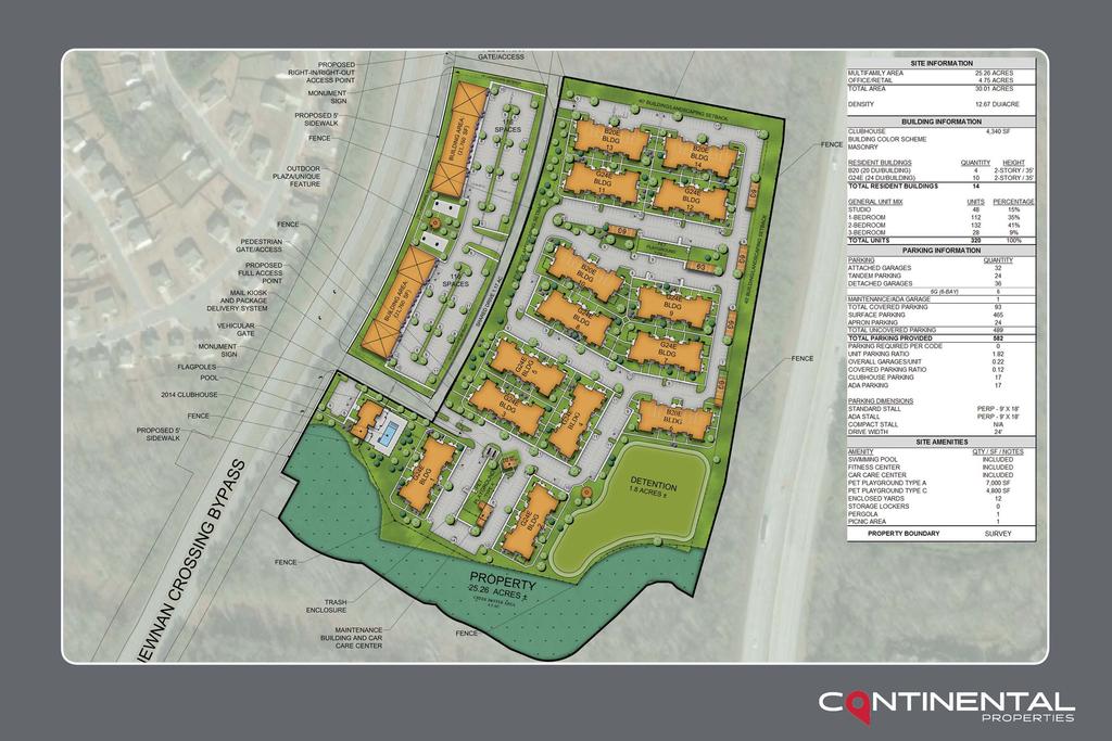
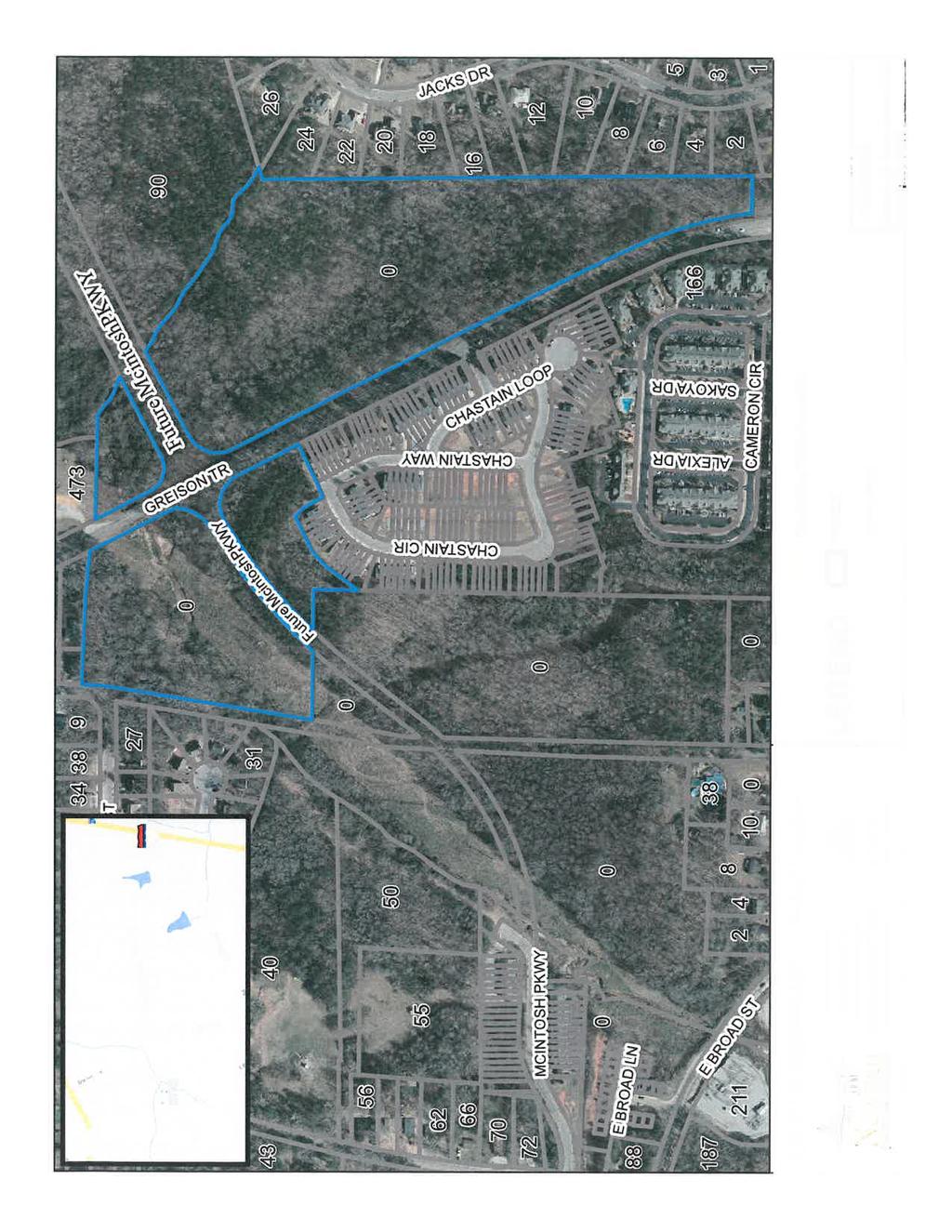
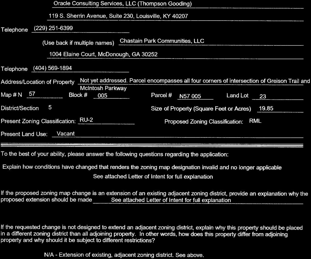
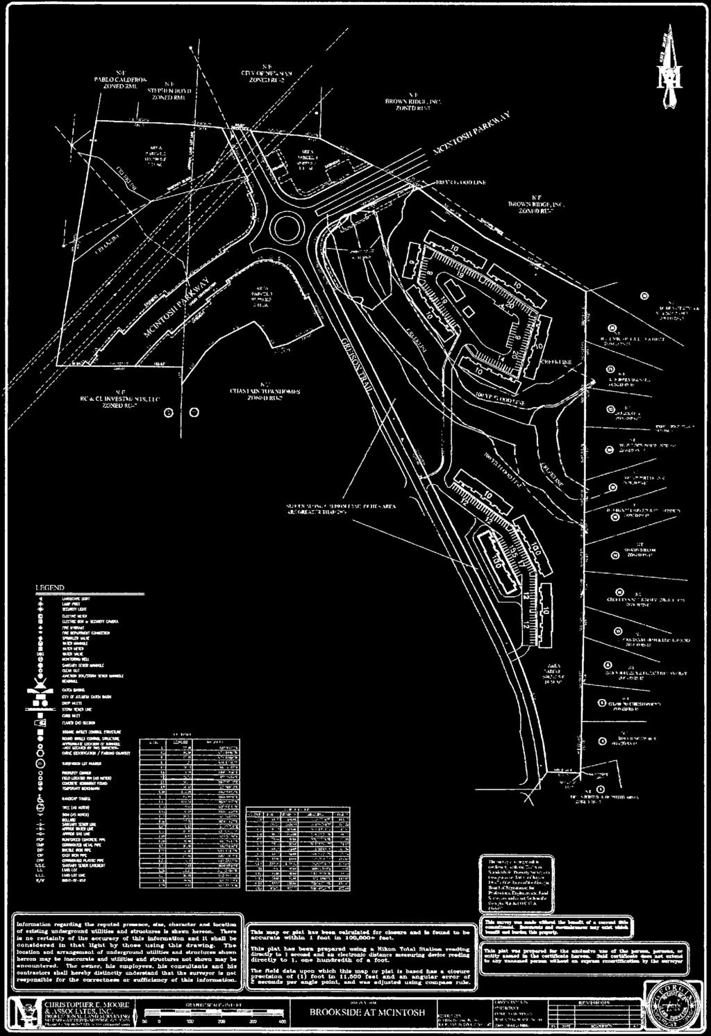
87 City of Newnan, Georgia Planning Commission Date: July 10, 2018 Agenda Item: Rezoning Request RZ ± acres on Greison Trail (Tax Parcel # N57 005) Prepared and Presented by: Tracy Dunnavant, Planning Director Purpose: Thompson Gooding, on behalf of Oracle Consulting Services, LLC, is seeking to change the zoning on a ± acre tract located on Greison Trail (Tax Parcel # N57 005). The applicant is proposing the development of a 96 unit townhouse style apartment complex. The 19.85± acres are currently zoned RU-2 (Townhouse Residential Dwelling District) and the applicant is seeking an RML (Residential Multiple Family Dwelling- Lower Density District) zoning designation. The applicant is proposing to build only on the south west portion of the property. He has agreed to proffer the other three tracts associated with this parcel to the City s LINC project. Background: The subject property is currently vacant and is located at the corners of Greison Trail and McIntosh Parkway where the City is proposing to build a new roundabout. The applicant is seeking an RML zoning to allow for townhouse style apartments in lieu of building townhouses on individual lots. The applicant has indicated that the site topography, McIntosh Parkway bisecting the site and the existing floodplain make it difficult to develop the site as a true townhouse development. The RU-2 zoning designation is a residual district that is no longer allowed as a new designation through rezoning. Present Zoning District Proposed Zoning District Current Land Use Parcel Size RU-2 RML Vacant ± acres Surrounding Zoning Classifications North East South West RU-2 and RML RU-7 and RS-15 RU-2 and RU-7 RU-2 and RU-7 Surrounding Land Use Pattern Public Safety Training North Facility/Single-Family Homes Proposed Single- East Family/Townhouse Development and Oracle Consulting Services, LLC Greison Trail Rezoning Request
88 South West Existing Single-Family Development Preswyck Pointe and Chastain Park (townhouse developments) Chastain Park, Columbia Woods Apartments and Residential Homes Summary: Staff analyzed the following criteria prior to formulating a recommendation: Is the proposed use suitable in view of the zoning and development of adjacent and nearby property? The subject property is primarily bordered by a mixture of single-family and townhouse developments. The tract will be split into four pieces with only the southeast quadrant being developed. The tract is already zoned for townhouses and the applicant is seeking to build townhouse style apartments with no increase in density beyond what is currently allowed. Staff feels that the proposed use would be suitable as the land abuts two major roads and will be located directly across the street from Chastain Park and just north of Preswyck Pointe (two existing townhouse developments). In addition, another townhouse style apartment complex, Columbia Woods, is located across Greison Trail to the south. There is also a single-family development to the east of the site, which the developer has indicated will be protected by an undisturbed buffer and a building setback of approximately 60 to 100 feet. Will the proposed use adversely affect the existing use or usability of adjacent or nearby property? In an effort to work with the neighboring single-family development that abuts the project to the rear, the developer held a meeting with the subdivision s residents. As a result, the following will be incorporated into the project design: 1) No rear entry or patio doors; 2) height limited of two stories; 3) mixture of exterior materials (brick & siding); 4) dumpster located to the interior of the site; 5) no swimming pool; and 6) maximum tree protection in the designated buffers. As this tract is not developed at present, there will be an increase in traffic for the Greison Trail area; however, it should be noted that this tract is currently zoned for a townhouse development and the City Engineer has indicated that the increase in traffic compared to the tract being developed with townhouses is minimal. In addition, all access will be on Greison Trail which should be able to handle any trips generated by the development since it is an urban collector. Are their substantial reasons why the property cannot or should not be used as currently zoned? The property is currently zoned for a townhouse development; however, the tract has been divided into four pieces due to the construction of McIntosh Parkway. With all townhouse units requiring road frontage, the existing powerline easement, an existing stream and Oracle Consulting Services, LLC Greison Trail Rezoning Request
89 topography issues, it will be difficult to divide the tracts into individual lots as required for a true townhouse development. The Engineering Department has stated that the proposed use as apartment style townhomes will significantly be less impactful to the environment since less road frontage is needed and they can achieve the same density with only crossing the stream one time. Will the proposed use cause an excessive or burdensome use of public facilities or services, including but not limited to streets, schools, water or sewer utilities, and police or fire protection? The following reflects the comments Staff received from the various departments regarding service provision: Engineering: Environmental Concerns: The development plan shall follow and comply fully with the Georgia Storm Water Management Manual, latest edition. All streams, wetlands and other environmentally sensitive areas such as, floodplain, shall be determined and located within open space to the extent practically possible. All streams shall carry an undisturbed stream buffer of 50 feet with an additional impervious surface setback of 25 feet. State waters buffers shall be measured from the point of wrested vegetation and shall be delineated in the field. The site contains regulatory floodway and floodplain and the proposed layout as shown should remain basically the same with only 1 stream crossing to minimize impacts to the stream. Access, Layout, and Road Concerns: 1. ADA compliant five (5) foot sidewalks shall be provided along the public right of way of Greison Trail and internally within the development including the road crossing the stream. The public sidewalk will need to connect to the existing sidewalk along Greison Trail at the roundabout. 2. All roads shown on the concept plan will be private roads and regardless of construction standards, will be maintained in perpetuity by the applicant/owner. 3. Based on projected traffic, decel lanes will be required at both entrances and a left turn lane will be required at the main entrance which shall line up with the existing entrance to Chastain Park across Greison Trail. Trip Generation: DAY Apartment Townhomes Difference Oracle Consulting Services, LLC Greison Trail Rezoning Request
90 WEEKDAY (vpd) WEEKDAY AM PEAK (vph) WEEKDAY PM PEAK (vph) There will be a slight increase in the projected trips using the apartment trip generation versus using the townhome trips. For purposes of the impacts to the City streets the higher apartment number was used. Assuming 50% split entering and exiting onto Greison Trail from the apartments will be 322 entering and 323 exiting per day. Based on existing traffic patterns and the network connection at McIntosh Parkway to the interstate we can assume the majority of the exiting traffic will go north (60/40 split) with approximately 194 vehicles per day traveling north existing the development. Based on this projection there will be approximately 194 vehicles making a left turn per day into the site with return trips therefore a left turn lane will be warranted. Greison Trail is an urban collector with approximately 8320 AADT and the increased traffic from this development at 645 trips per day represents 7.75% increase in total trips. With existing roundabouts at each end of Greison Trail this increase in traffic is not anticipated to cause excess delay at either terminal intersection adjacent to this site. Sidewalks along Greison trail will provide pedestrian connectivity to the existing sidewalk network and the future LINC which will be crossing the northern section of the tract. The proposed use as apartment style townhomes will significantly be less impactful to the environment since less road frontage is needed and they can achieve the same density with only crossing the stream one time. School: Ronald Cheek, Director of Facilities for the Coweta County School System, did not respond to date; however, in the past he has offered the following: In our experience, residents of apartment dwellings are often more transient than those in single family dwellings. This may present challenges when planning for school enrollment and meeting student needs. School capacity is an ongoing concern. If approved, the school system would request that the developer provide advanced notice of the following information for our planning purposes : Police: What is the construction schedule for the project? What is the proposed build-out timeline? Will the project be built in phases? Will there be a targeted market, e.g., senior citizens? In reviewing historical information concerning number of calls for service, response time, and number of officers, following is the impact to the police department services. The numbers are projected with 41 Officers being used to determine calls per officers. These 41 officers are patrol officers who will normally be the first responders to any call for service. Oracle Consulting Services, LLC Greison Trail Rezoning Request
91 Annual Calls for service Estimated Population Calls per citizen Calls per Officer Estimated occupants each new resident Calls per additional resident Additional calls per Officer Estimated time on each call Response time increase from/to 54,000 34, , hour 4.2 min to 5 min. While these numbers may appear to be low in number, it does take and officer off of the street longer than just taking information, and filing a report. We would be able to service this development, but it would require a longer response time. Newnan Utilities: Scott Tolar has indicated that Newnan Utilities does have ample water and sewer capacity to serve the proposed development. The developer will be responsible for all upgrade costs necessary to serve the property. Fire: Fire Chief, Stephen Brown, has indicated that his department would be able to service the development with their existing personnel and equipment. Is the proposed use compatible with the purpose and intent of the comprehensive plan? The Future Land Use Map shows the property on the east side of Greison Trail as high density residential (between 7 and 12 units per acre) with a little bit of office and professional land. The west side is shown as medium density residential (between 4 and 7 units per acre). The multi-family development would be consistent with the residential designations but not with the office and professional portion. Will the use be consistent with the purpose and intent of the proposed zoning district? The proposed use would be consistent with the purpose and intent of the proposed zoning as townhouse style apartments would be an allowable use in an RML zoning designation. Is the proposed use supported by new or changing conditions not anticipated by the comprehensive plan? As specified above, the Future Land Use map shows this property as primarily high residential and medium residential with a small portion being office and professional. Since this designation was just assigned in October of 2017, there are no new or changing conditions that would impact the designation shown in the Comprehensive Plan. The Council was aware of both the McIntosh Parkway and LINC projects at the time of the update. Does the proposed use reflect a reasonable balance between the promotion of the public health, safety, morality, or general welfare and the right to unrestricted use of property? Staff feels the proposed use for the property does reflect a reasonable balance. The property is already zoned for 99 townhouses and the applicant is not asking for any more density than is currently allowed. In addition, Greison Trail should be able to handle the additional traffic with any needed road improvements being addressed by the developer. Also, the applicant has met Oracle Consulting Services, LLC Greison Trail Rezoning Request
92 with the neighboring property owners who will see the greatest impact and has made concessions based on their input that will be reflected on the updated plans. Proffered Conditions: The applicant has agreed to proffer the following conditions: If the site is purchased and developed by the applicant, Oracle Consulting Services agrees to donate the tree smaller sections of the parcel (located at the north, south and west corners of the intersection of Greison Trail and McIntosh Parkway) to the city or its designated entity for the purpose of developing the Newnan LINC Trail System. Provided, however, that any development rights, including but not limited to density, shall remain with the applicant s parcel. Applicant agrees to maintain the existing density limit of no more than 5 units per acre. Options: A. Approve the rezoning request as submitted B. Approve the rezoning request, with conditions C. Deny the rezoning request Staff Recommendation: As with all growing municipalities, there is a need to provide housing opportunities for individuals who do not desire or cannot afford home ownership. This need increases as more retail and service providers locate within the Newnan area bringing more moderate paying jobs and as more active adults change their housing preference to a more maintenance free lifestyle. When there are few parcels left to accommodate large multi-family developments, the City sees an increase in rezoning and annexation requests to fill that need. The dilemma that arises is how to strike a balance between meeting that need and oversaturating the market. Since 2013, the City has approved around 960 new multi-family units. Eight hundred of the units are higher end apartments (Trees of Newnan and The Residences at Newnan Crossing) which will rent between $900 to $2,000 per month depending upon unit size and number of bedrooms. One hundred and sixty are more affordable apartments (Jefferson Grove Apartments) with rents based on income. Of the 960 units, 500 are currently built and the other 460 are being permitted. During that same period, the City has added 1.5 million square feet of commercial, office, and industrial space per the Building Department. With the Poplar Road interchange opening next year and the build out of the Newnan Crossing Boulevard East development, this figure will continue to increase bringing more workers looking for housing options near their jobs. After reviewing the application and the rezoning criteria, Staff feels that the impact from allowing the tract to be developed with townhouse style apartments will be minimal to the surrounding area. The parcel is already zoned for 99 townhouse units and the applicant is not going to be increasing density. In addition, the Engineering Department has indicated that the apartments will generate only 76 more trips per day, with only 7 more during the morning peak and 9 more during evening peak. The existing easements, limited access on McIntosh Parkway, site Oracle Consulting Services, LLC Greison Trail Rezoning Request
93 topography, and existing stream/floodplain severely limits the applicant s ability to construct a traditional townhouse product. In addition, the Engineering Department has concluded that the apartments will be less impactful on the environment since they will be able to achieve the same density with only one stream crossing. Therefore, if the Commission no longer envisions this area as a mixture of future high density residential and office and professional uses, Staff would recommend Option B, approve the rezoning request with the following conditions: 1) The development of the property will be consistent with the concept plan, elevations, amenities and supporting documentation that has been provided as part of the rezoning application package including all changes to be incorporated into the project design from the applicant s meeting with the local residents: 1) No rear entry or patio doors; 2) height limited to two stories; 3) mixture of exterior materials (brick & siding); 4) dumpster located to the interior of the site; 5) no swimming pool; and 6) maximum tree protection in the designated buffers. 2) All roads shown on the concept plan will be private roads and regardless of construction standards, will be maintained in perpetuity by the applicant/owner. 3) Decel lanes will be required at both entrances and a left turn lane will be required at the main entrance which shall line up with the existing entrance to Chastain Park across Greison Trail. 4) The development will adhere to all conditions proffered by the applicant regarding the donation of land for the LINC project and the limitation on density not to exceed 5 units per acre. Attachments: Application for Rezoning Location Map Concept Plan Service Provision Responses Previous Discussions with Commission: None Oracle Consulting Services, LLC Greison Trail Rezoning Request


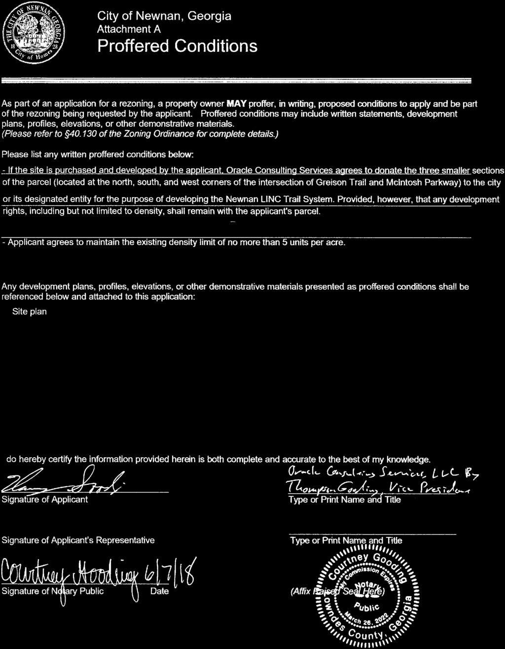
94
95

96
97
98
99


100

101

102


103
104
105
106
107
108


109

110 Similar Project Preliminary Site Plan BROOKSIDE AT McINTOSH PROPOSED RESIDENTIAL DEVELOPMENT NEWNAN, GEORGIA Conceptual Drawing, Typical Building


111 SITE STATISTICS - 10 Buildings - 96 Units Total - 64 Two Bedroom - 32 Three Bedroom Parking Spaces Required - Playground - Fitness Center - Computer Center - Grilling Pavilion - LINC Trail Connection POTENTIAL PLAYGROUND 2

112 Building Design CONCEPTUAL RENDERING SIMILAR PREVIOUS PROJECT 3
113 Zoning & Local Impact ZONING Current zoning RU-2 (No longer in use) Up to 98 Units Unlimited 3-Bedroom Units Max 294 bedrooms Proposed Zoning RML (Low-Density) Proposed: 96 Units Capped by zoning condition Limit on 3-Bedrooms Max 220 bedrooms Minimum rear setback 40 Proposed setback/buffer Undisturbed as much as possible Comprehensive Plan & Future Land Use Map show Medium-Density Residential JOBS National Homebuilders Association Center for Housing Policy: 1 permanent job created for every $1.5 million spent on projects jobs from this project jobs on site during construction REVENUE TO COUNTY Tap & impact fee revenue Building permit and related fees Increased annual property tax revenue Increased sales tax revenue Increased utility service income BENEFITS TO LOCAL VENDORS Restaurants Material Suppliers Hotels Maintenance Trades Up to 152 Units 4
 Locate dumpsters to interior of site No swimming pool Maximize tree protection and buffers")
114 Neighborhood Input Meeting with neighborhood May 23 rd Feedback incorporated into design: No rear entry or patio doors Limit height to two stories Mix of exterior material (brick & siding) Locate dumpsters to interior of site No swimming pool Maximize tree protection and buffers 5
115 Target Market Target households at 57% to 94% of Newnan median income ($51,693) Sample Jobs at Target Incomes in Newnan Unit Type Targeted HH Income Proposed Monthly Rents Firefighter/Paramedic - $42,611 Customer Service Rep, Local E-Commerce Company - $35,000 Two BR $29,500 to $40,440 $820 to $880 Executive Assistant - $37,907 Insurance Sales - $41,000 Legal Assistant - $32,000 Restaurant Manager - $28,700 Three BR $33,300 to $48,480 $925 to $1,000 * Actual Locally-Advertised Jobs 6
116 Economic Development Construction of new affordable housing, as well as programs that rehabilitate existing housing stock to make it affordable, create a host of jobs Local businesses that supply building materials and other supplies benefit from the sale of such products or services to the building contractors. Local governments reap the benefit of increased income in the form of occupational license fees or net profits from the jobs and services being provided. Often, affordable housing is constructed on vacant, underutilized parcels because they are more cost-effective to develop. This increases the value of the property, which in turn means increased property taxes that flow to local and state governments and local school boards. Households that pay less for housing costs can afford to spend more on other items, including groceries, clothing and health care. They can also afford to save more for emergencies or for major purchases such as a car or education. Businesses benefit by having a stable employee population because it reduces employee turnover and related costs in training new employees. It also reduces problems associated with lack of dependability as to whether a sufficient number of employees will show up to work their shifts. Government policies that encourage affordable housing, including programs that provide incentives for private developers to build affordable housing are an important, if underutilized, way to grow the economy and contribute to the overall prosperity of the entire community. Source: The National Law Review, Affordable Housing is an Economic Development Benefit, February 26, 2015, Christine Neal Westover, McBrayer, McGinnis, Leslie & Kirkland, PLLC 7
117 8 Questions
118 The City of Newnan, Georgia Public Works Department 06/29/2018 Engineering Department Review REZONING REQUEST Oracle Consulting 98 unit townhouse apartments N Environmental Concerns: 1. The development plan shall follow and comply fully with the Georgia Storm Water Management Manual, latest edition. 2. All streams, wetlands and other environmentally sensitive areas such as, floodplain, shall be determined and located within open space to the extent practically possible. 3. All streams shall carry an undisturbed stream buffer of 50 feet with an additional impervious surface setback of 25 feet. State waters buffers shall be measured from the point of wrested vegetation and shall be delineated in the field. 4. The site contains regulatory floodway and floodplain and the proposed layout as shown should remain basically the same with only 1 stream crossing to minimize impacts to the stream. Sidewalk and Road Concerns: 1. ADA compliant five (5) foot sidewalks shall be provided along the public right of way of Greison Trail and internally within the development including the road crossing the stream. The public sidewalk will need to connect to the existing sidewalk along Greison Trail at the roundabout. 2. All roads shown on the concept plan will be private roads and regardless of construction standards, will be maintained in perpetuity by the applicant/owner. 3. Based on projected traffic, decel lanes will be required at both entrances and a left turn lane will be required at the main entrance which shall line up with the existing entrance to Chastain Park across Greison Trail. 25 La Grange Street Newnan, Georgia (770)
119 Traffic Analysis: Compare impacts of low rise apartments vs. townhomes Low Rise Apartments: 98 units a. Weekday : 6.59 /unit = 645 vpd b. Weekday peak AM hour:.51/unit = 50 vph c. Weekday peak PM hour:.62/unit = 60 vph Townhomes: 98 units a. Weekday: 5.81/unit = 569 vpd b. Weekday peak AM hour = 0.44/unit = 43 vph c. Weekday peak PM hour = 0.52/unit = 51 vph TRAFFIC GENERATION SUMMARY DAY Apartment Townhomes Difference WEEKDAY (vpd) WEEKDAY AM PEAK (vph) WEEKDAY PM PEAK (vph) There will be a slight increase in the projected trips using the apartment trip generation versus using the townhome trips. For purposes of the impacts to the City streets the higher apartment number was used. Assuming 50% split entering and exiting onto Greison Trail from the apartments will be 322 entering and 323 exiting per day. Based on existing traffic patterns and the network connection at McIntosh Parkway to the interstate we can assume the majority of the exiting traffic will go north (60/40 split) with approximately 194 vehicles per day traveling north existing the development. Based on this projection there will be approximately 194 vehicles making a left turn per day into the site with return trips therefore a left turn lane will be warranted. Greison Trail is an urban collector with approximately 8320 AADT and the increased traffic from this development at 645 trips per day represents 7.75% increase in total trips. With existing roundabouts at each end of Greison Trail this increase in traffic is not anticipated to cause excess delay at either terminal intersection adjacent to this site. Sidewalks along Greison trail will provide pedestrian connectivity to the existing sidewalk network and the future LINC which will be crossing the northern section of the tract. The proposed use as apartment style townhomes will significantly be less impactful to the environment since less road frontage is needed and they can achieve the same density with only crossing the stream one time.
120 NEWNAN POLICE DEPARTMENT CITY OF NEWNAN 1 Joseph Hannah Blvd P.O. Box 1193 Newnan, GA FAX: July 5, 2018 To: Tracy Dunnavant Planning and Zoning Director Reference: Rezoning RZ Greison Trail Dear Mrs. Dunnavant, In reviewing historical information concerning number of calls for service, response time, and number of officers, following is the impact to the police department services. The numbers are projected with 41 Officers being used to determine calls per officers. These 41 officers are patrol officers who will normally be the first responders to any call for service. Annual Calls for service Estimated Population Calls per citizen Calls per Officer Estimated occupants each new resident Calls per additional resident Additional calls per Officer Estimated time on each call Response time increase from/to 54,000 34, , hour 4.2 min to 5 min. While these numbers may appear to be low in number, it does take and officer off of the street longer than just taking information, and filing a report. We would be able to service this development, but it would require a longer response time. Respectfully, Douglas L. Meadows Chief of Police
121
122 February 27, 2018 Mr. Thompson Gooding Oracle Consulting Services Subject: Parcel # N57 005, Brookside at McIntosh Parkway, Newnan Georgia Mr. Gooding, I am writing per your request to confirm that Newnan Utilities will be the water and sewer service provider for the above referenced project. At this time, Newnan Utilities also has ample capacity to serve this proposed facility, based on the following information: 1. The City of Newnan and Newnan Utilities approves current design plan, Exhibit A. 2. Parcel Number N Acres 4. Sanitary Sewer: a. Developer shall connect to Newnan Utilities Sanitary Sewer System. b. Developer is responsible for all upgrade cost necessary to serve said property, but not limited to: i. Design and Construction of development sanitary sewer system per Newnan Utilities Specifications. ii. Design and construction of connection to Newnan Utilities Sanitary Sewer System. iii. Cost for analyzing existing sanitary sewer system by an engineer firm approved by Newnan Utilities. iv. Existing sanitary sewer upgrades to handle proposed development. This is to include any lift station upgrades, gravity sanitary sewer upgrades, sanitary sewer force main upgrades, and any other upgrades deemed necessary by Newnan Utilities. v. Line extension fees associated with connection to Newnan Utilities Sanitary Sewer System. vi. Sanitary Sewer Impact fees associated with connection to Newnan Utilities Sanitary Sewer System. 70 Sewell Road Newnan, GA fax
123 5. Water: a. Developer shall connect to Newnan Utilities Water System. b. Developer is responsible for all upgrade cost necessary to serve said property, but not limited to: i. Construction of development water system per Newnan Utilities Specifications. ii. Design and construction of connection to Newnan Utilities Water System. iii. Cost for analyzing existing water sewer system by an engineer firm approved by Newnan Utilities. iv. Existing water upgrades to handle proposed development. This is to include water system upgrades, fire protection upgrades, and any other upgrades deemed necessary by Newnan Utilities. v. Line extension fees associated with connection to Newnan Utilities Sanitary Sewer System. Please let me know if you have any questions or need additional information. Sincerely, Scott Tolar, P.E. Newnan Utilities 70 Sewell Road Newnan, GA fax

124 EXHIBIT A 70 Sewell Road Newnan, GA fax
O-I (Office-Institutional) and AG-1(Agricultural)
 and AG-1(Agricultural)") PROPERTY INFORMATION ADDRESS 3503 and 3505 Bethany Bend DISTRICT, LAND LOTS 2/1 973 and 974 OVERLAY DISTRICT State Route 9 PETITION NUMBERS EXISTING ZONING O-I (Office-Institutional) and AG-1(Agricultural)
PROPERTY INFORMATION ADDRESS 3503 and 3505 Bethany Bend DISTRICT, LAND LOTS 2/1 973 and 974 OVERLAY DISTRICT State Route 9 PETITION NUMBERS EXISTING ZONING O-I (Office-Institutional) and AG-1(Agricultural)
DEVELOPMENT DEPARTMENT STAFF REPORT STAFF REPORT DRESDEN DRIVE TOWNHOMES DCI
 DEVELOPMENT DEPARTMENT STAFF REPORT Meeting Date: September 13, 2018 Item #: PZ2018-319 STAFF REPORT DRESDEN DRIVE TOWNHOMES DCI Request: Project Name: Development of Community Compact (DCI) and six concurrent
9. REZONING NO Vicinity of the northwest corner of 143 rd Street and Metcalf Avenue
 9. REZONING NO. 2002-15 Vicinity of the northwest corner of 143 rd Street and Metcalf Avenue 1. APPLICANT: Andrew Schlagel is the applicant for this request. 2. REQUESTED ACTION: The applicant is requesting
Planning Department Oconee County, Georgia STAFF REPORT
 Planning Department Oconee County, Georgia STAFF REPORT REZONE CASE #: 7332 DATE: November 28, 2017 STAFF REPORT BY: Gabriel Quintas, Planner APPLICANT NAME: Smith Planning Group PROPERTY OWNER: John Hadden
Town of Cary, North Carolina Rezoning Staff Report 14-REZ-31 Cary Park PDD Amendment (Waterford II) Town Council Meeting January 15, 2015
 Town Council Meeting January 15, 2015") Town of Cary, North Carolina Rezoning Staff Report 14-REZ-31 Cary Park PDD Amendment (Waterford II) Town Council Meeting January 15, 2015 REQUEST To amend the Town of Cary Official Zoning Map by amending
Town of Cary, North Carolina Rezoning Staff Report 14-REZ-31 Cary Park PDD Amendment (Waterford II) Town Council Meeting January 15, 2015 REQUEST To amend the Town of Cary Official Zoning Map by amending
Staff Report & Recommendation Rezoning Case RZ Date of Report: June 6, 2014 Report by: Doug Stacks
 Staff Report & Recommendation Rezoning Case RZ-2014-02 Date of Report: June 6, 2014 Report by: Doug Stacks Hearing Dates: Planning Commission June 26, 2014 Mayor and Council July 14, 2014 GENERAL INFORMATION
BARROW COUNTY, GEORGIA
 BARROW COUNTY, GEORGIA Application For Rezoning, Special Use, and Change in Conditions BARROW COUNTY DEPARTMENT OF PLANNING AND DEVELOPMENT 30 North Broad Street Winder, Georgia 30680 770-307-3034 APPLICATION
DEVELOPMENT DEPARTMENT STAFF REPORT STAFF REPORT MCDONALD S ZONING MAP AMENDMENT AND CONCURRENT VARIANCES
 DEVELOPMENT DEPARTMENT STAFF REPORT Meeting Date: October 12, 2017 Item #: _PZ2017-172_ STAFF REPORT MCDONALD S ZONING MAP AMENDMENT AND CONCURRENT VARIANCES Request: Rezone property from MU-BC to CC,
PLAINFIELD CHARTER TOWNSHIP COMMUNITY DEVELOPMENT DEPARTMENT PLANNING, ZONING & BUILDING SERVICES MEMORANDUM
 PLAINFIELD CHARTER TOWNSHIP COMMUNITY DEVELOPMENT DEPARTMENT PLANNING, ZONING & BUILDING SERVICES 6161 BELMONT AVENUE N.E. BELMONT, MI 49306 PHONE 616-364-1190 FAX: 616-364-1170 www.plainfieldchartertwp.org
ZONING AMENDMENT & SUBDIVISION STAFF REPORT Date: July 3, 2014
 ZONING AMENDMENT & SUBDIVISION STAFF REPORT Date: July 3, 2014 APPLICANT NAME SUBDIVISION NAME LOCATION Georgia Crown Distributing Subdivision Georgia Crown Distributing Subdivision Southwest corner of
Boise City Planning & Zoning Commission Minutes November 3, 2014 Page 1
 Page 1 PUD14-00020 / 2 NORTH HOMES, LLC Location: 2818 W. Madison Avenue CONDITIONAL USE PERMIT FOR A FOUR UNIT PLANNED RESIDENTIAL DEVELOPMENT ON 0.28 ACRES LOCATED AT 2818 & 2836 W. MADISON AVENUE IN
Community Development
 Land Use Petition RZ-16-002 Date of Staff Recommendation Preparation: April 15, 2016 (CEL) Date of Planning Commission Recommendation: May 3, 2016 PROJECT LOCATION: DISTRICT/SECTION/LANDLOT(S): ACREAGE
Planning Department Oconee County, Georgia
 Planning Department Oconee County, Georgia STAFF REPORT REZONE CASE #: 6985 DATE: October 31, 2016 STAFF REPORT BY: Andrew C. Stern, Planner APPLICANT NAME: Williams & Associates, Land Planners PC PROPERTY
REGULAR MEETING OF LURAY PLANNING COMMISSION APRIL 13, 2016
 REGULAR MEETING OF LURAY PLANNING COMMISSION The Luray Planning Commission met on Wednesday, April 13, 2016 at 7:00 p.m. in regular session. The meeting was held in the Luray Town Council Chambers at 45
Town of Cary, North Carolina Rezoning Staff Report 12-REZ-27 Morris Branch Town Council Public Hearing January 24, 2013
 Town of Cary, North Carolina Rezoning Staff Report 12-REZ-27 Morris Branch Town Council Public Hearing January 24, 2013 REQUEST To amend the Town of Cary Official Zoning Map to rezone approximately 9.0
Perry City Planning Commission Perry City Offices, 3005 South 1200 West April 5, :00 PM
 Perry City Planning Commission Perry City Offices, 3005 South 1200 West April 5, 2012 7:00 PM Members Present: Chairman Jerry Nelson, Commissioner Esther Montgomery, Commissioner Todd Bischoff, Commissioner
Conditional Use Permit case no. CU 14-06: Bristol Village Partners, LLC
 PLANNING AND ZONING COMMISSION STAFF REPORT August 7, 2014 Conditional Use Permit case no. CU 14-06: Bristol Village Partners, LLC CASE DESCRIPTION: LOCATION: LEGAL DESCRIPTION: EXISTING LAND USE: ZONING:
Request Conditional Rezoning (R-7.5 Residential to Conditional A-18 Apartment) Staff Recommendation Approval. Staff Planner Jimmy McNamara
 Staff Recommendation Approval. Staff Planner Jimmy McNamara") Applicants Property Owners Baker Villas, LLC; Ocean Rental Properties, LLC; James Edward Sollner; & Linda Susan Sollner Public Hearing November 8, 2017 City Council Election District Kempsville Agenda
Applicants Property Owners Baker Villas, LLC; Ocean Rental Properties, LLC; James Edward Sollner; & Linda Susan Sollner Public Hearing November 8, 2017 City Council Election District Kempsville Agenda
M E M O R A N D U M. Meeting Date: October 23, Item No. F-1. Planning and Zoning Commission. Daniel Turner, Planner I
 M E M O R A N D U M Meeting Date: October 23, 2017 Item No. F-1 To: From: Subject: Planning and Zoning Commission Daniel Turner, Planner I PUBLIC HEARING: Consider a recommendation of a of Planned Development
EDGERTON CITY HALL PLANNING COMMISSION MEETING REGULAR SESSION March 12, 2019
 EDGERTON CITY HALL PLANNING COMMISSION MEETING REGULAR SESSION The met in regular session with Chair John Daley calling the meeting to order at 7:00 p.m. All present participated in the Pledge of Allegiance.
Cobb County Community Development Agency Zoning Division 1150 Powder Springs St. Marietta, Georgia 30064
 Cobb County Community Development Agency Zoning Division 1150 Powder Springs St. Marietta, Georgia 30064 Case # Z-63 Public Hearing Dates: PC: 11-06-18 BOC: 11-20-18 SITE BACKGROUND Applicant: Loyd Development
APPLICANT NAME SUBDIVISION NAME DEVELOPMENT NAME LOCATION. CITY COUNCIL DISTRICT Council District 4 PRESENT ZONING PROPOSED ZONING
 SUBDIVISION, PLANNED UNIT DEVELOPMENT, PLANNING APPROVAL, ZONING AMENDMENT, & SIDEWALK WAIVER REQUEST STAFF REPORT Date: February 17, 2010 APPLICANT NAME SUBDIVISION NAME DEVELOPMENT NAME LOCATION David
DEVELOPMENT DEPARTMENT STAFF REPORT THE PARK AT 5 TH
 DEVELOPMENT DEPARTMENT STAFF REPORT ARB Meeting Date: July 3, 2018 Item #: _PZ2018-293_ THE PARK AT 5 TH Request: Site Address: Project Name: Parcel Number: Applicant: Proposed Development: Current Zoning:
PLANNING AND DEVELOPMENT DEPARTMENT STAFF REPORT SAVOY DRIVE AREA ZONING MAP AMENDMENT II
 PLANNING AND DEVELOPMENT DEPARTMENT STAFF REPORT Meeting Date: March 14, 2019 Item #: PZ2019-429 SAVOY DRIVE AREA ZONING MAP AMENDMENT II Project Name: Savoy Drive Area Zoning Map Amendment II Site Addresses:
DEVELOPMENT DEPARTMENT STAFF REPORT DRESDEN HEIGHTS PHASE II DCI
 DEVELOPMENT DEPARTMENT Meeting Date: January 10, 2019 Item #: PZ2019-393 Project Name: Applicant and Owner: Proposed Development: Requests: STAFF REPORT DRESDEN HEIGHTS PHASE II DCI Dresden Heights Phase
Cover Letter with Narrative Statement
 Cover Letter with Narrative Statement March 31, 2017 rev July 27, 2017 RE: Rushton Pointe Residential Planned Unit Development Application for Public Hearing for RPUD Rezone PL2015 000 0306 Mr. Eric Johnson,
CONCEPT PLAN SUBMISSION REQUIREMENTS:
 STAFF STRONGLY RECOMMENDS A PRE-DEVELOPMENT MEETING BEFORE THE SUBMITTAL OF ANY APPLICATION FOR ZONING, REZONING, CONDITIONAL USE PERMIT (CUP), OR FOR A TEXT AMENDMENT TO A PROVISION(S) OF THE ZONING ORDINANCE.
Agenda Information Sheet
 Page 90 Agenda Information Sheet December 13, 2018 Agenda Item Z-18-10 - Conduct a public hearing and consider approval of an ordinance rezoning a 33.4 tract of land out of the H. Teal Survey Abstract
Recommend approval of the Variances identified and Rezone to Residential Multi-Family (RM) District with following conditions:
 District with following conditions:") City of Sugar Hill Planning Staff Report RZ 17-001 DATE: June 20, 2017: Updated 7/10/17 TO: Mayor and City Council FROM: Tim Schick, Administrative Staff SUBJECT: Rezoning RZ 17-001 Rezoning with Variances
City of Sugar Hill Planning Staff Report RZ 17-001 DATE: June 20, 2017: Updated 7/10/17 TO: Mayor and City Council FROM: Tim Schick, Administrative Staff SUBJECT: Rezoning RZ 17-001 Rezoning with Variances
Staff Report: Date: Applicant: Property Identification: Acreage of Request: Current Zoning of Requested Area: Requested Action: Attached:
 Staff Report: Completed by Jeff Palmer Director of Planning & Zoning Date: November 7, 2018, Updated November 20, 2018 Applicant: Greg Smith, Oberer Land Developer agent for Ronald Montgomery ET AL Property
City of Peachtree City. Annexation Review Process
 City of Peachtree City Annexation Review Process Page 1 Annexation Review Process Step One: Initial annexation information The following information is to be completed by the property owner and/ or their
Community Development
 Land Use Petition RZ-15-010 Concurrent Variance VC-15-010-01 Date of Staff Recommendation Preparation: August 14, 2015 Date of Planning Commission Recommendation: September 1, 2015 PROJECT LOCATION: DISTRICT/SECTION/LANDLOT(S):
PALM BEACH COUNTY PLANNING, ZONING AND BUILDING DEPARTMENT ZONING DIVISION
 PALM BEACH COUNTY PLANNING, ZONING AND BUILDING DEPARTMENT ZONING DIVISION Application No.: CA-2012-00688 Control No.: 2011-00552 Applicant: Garry Bernardo Owners: Garry Bernardo Agent: Frogner Consulting,
1. The meeting was called to Order with Roll Call by Chairman Richard Hemphill.
 PLANNING COMMISSION City Hall, 32905 W. 84 th Street 6:00 PM., August 22nd, 2017 MINUTES 1. The meeting was called to Order with Roll Call by Chairman Richard Hemphill. 2. Roll Call: Allenbrand Absent
Planned Residence District (PR) To review a plan to construct 11 single family homes on approximately 4.01 acres.
 To review a plan to construct 11 single family homes on approximately 4.01 acres.") STAFF REPORT PLANNING & ZONING COMMISSION Village Green Municipal Building, Council Chambers 47 Hall Street Wednesday, March 13, 2019 7:00 P.M. 1. FINAL DEVELOPMENT PLAN REVIEW Applicant: Romanelli and
STAFF REPORT PLANNING & ZONING COMMISSION Village Green Municipal Building, Council Chambers 47 Hall Street Wednesday, March 13, 2019 7:00 P.M. 1. FINAL DEVELOPMENT PLAN REVIEW Applicant: Romanelli and
1 September 9, 2015 Public Hearing
 1 September 9, 2015 Public Hearing APPLICANT & PROPERTY OWNER: HOLLOMON- BROWN FUNERAL HOME, INC. STAFF PLANNER: Carolyn A.K. Smith REQUEST: Change of Zoning (R-5D Residential District to Conditional O-2
Request Subdivision Variance (Section 4.4(c)(1) of the Subdivision Regulations) Staff Recommendation Approval. Staff Planner Jonathan Sanders
(1) of the Subdivision Regulations) Staff Recommendation Approval. Staff Planner Jonathan Sanders") Applicant & Owner Public Hearing February 14, 2018 City Council Election District Bayside Agenda Item 4 Request Subdivision Variance (Section 4.4(c)(1) of the Subdivision Regulations) Staff Recommendation
Applicant & Owner Public Hearing February 14, 2018 City Council Election District Bayside Agenda Item 4 Request Subdivision Variance (Section 4.4(c)(1) of the Subdivision Regulations) Staff Recommendation
Staff Report: Date: Applicant: Property Identification: Acreage of Request: Current Zoning of Requested Area: Requested Action: Attached:
 Staff Report: Completed by Jeff Palmer Director of Planning & Zoning Date: November 7, 2018 Applicant: Greg Smith, Oberer Land Developer agent for Ronald Montgomery ET AL Property Identification: Frontage
PLANNED UNIT DEVELOPMENT & SUBDIVISION STAFF REPORT Date: April 18, 2019
 PLANNED UNIT DEVELOPMENT & SUBDIVISION STAFF REPORT Date: April 18, 2019 DEVELOPMENT NAME SUBDIVISION NAME Springhill Village Subdivision Springhill Village Subdivision LOCATION 4350, 4354, 4356, 4358,
3 July 13, 2011 Public Hearing APPLICANT / PROPERTY OWNER: MARQUETTE & ASSOCIATES, L.L.C. /G.S. DEVELOPERS, L.L.C.
 3 July 13, 2011 Public Hearing APPLICANT / PROPERTY OWNER: MARQUETTE & ASSOCIATES, L.L.C. /G.S. DEVELOPERS, L.L.C. STAFF PLANNER: Faith Christie REQUEST: Conditional Change of Zoning (AG-2 Agricultural
City of Brooklyn Park Planning Commission Staff Report
 City of Brooklyn Park Planning Commission Staff Report Agenda Item: 6D Meeting Date: August 9, 2017 Originating Agenda Section: Public Hearing Department: Community Development Resolution: X Ordinance:
PLANNED DEVELOPMENT DISTRICT STANDARDS. Cadence Site
 PLANNED DEVELOPMENT DISTRICT STANDARDS Cadence Site A Planned Development District 1. Statement of General Facts, Conditions and Objectives Property Size: Approximately 57.51 Acres York County Tax Map
Georgetown Planning Department
 Georgetown Planning Department Zoning Board of Adjustment Staff Report Meeting Date: March 19, 2013 Item: 4 File No: VAR-2013-002 Project Planner: Mike Elabarger, Senior Planner Report Date: March 14,
Courtyards at Kinnamon Park Sketch Plan
 Courtyards at Kinnamon Park Sketch Plan Courtyards at Kinnamon Park Sketch Plan Staff Analysis PART 1: PROJECT SUMMARY Applicant: EPCON Communities Property Owner: Johnsie M. Kinnamon Heirs, Douglas and
Operating Standards Attachment to Development Application
 Planning & Development Services 2255 W Berry Ave. Littleton, CO 80120 Phone: 303-795-3748 Mon-Fri: 8am-5pm www.littletongov.org Operating Standards Attachment to Development Application 1 PLANNED DEVELOPMENT
CHEBOYGAN COUNTY ZONING BOARD OF APPEALS
 CHEBOYGAN COUNTY ZONING BOARD OF APPEALS 870 SOUTH MAIN ST. PO BOX 70 CHEBOYGAN, MI 49721 PHONE: (231)627-8489 FAX: (231)627-3646 CHEBOYGAN COUNTY ZONING BOARD OF APPEALS MEETING & PUBLIC HEARING WEDNESDAY,
Staff Report for Town Council
 Staff Report for Town Council Meeting Date: June 22, 2017 16-REZ-24 Trimble Avenue Residential Rezoning Purpose: Consider action on proposed rezoning request Prepared by: Katie Drye, Planning Speaker:
PLANNING COMMISSION Minutes
 MEETING DATE: Monday January 22, 2018 MEETING TIME: 6:00 PM MEETING LOCATION: City Council Chambers, 448 E. First Street, Suite 190, Salida, CO Present: Mandelkorn, Follet, Denning, Thomas, Farrell, Bomer,
PLANNED UNIT DEVELOPMENT (East), PLANNED UNIT DEVELOPMENT (West) STAFF REPORT Date: September 18, 2014
, PLANNED UNIT DEVELOPMENT (West) STAFF REPORT Date: September 18, 2014") PLANNED UNIT DEVELOPMENT (East), PLANNED UNIT DEVELOPMENT (West) STAFF REPORT Date: September 18, 2014 DEVELOPMENT NAME LOCATION McGowin Park, LLC PLANNED UNIT DEVELOPMENT (East) 1401 Satchel Paige Drive
PLANNED UNIT DEVELOPMENT (East), PLANNED UNIT DEVELOPMENT (West) STAFF REPORT Date: September 18, 2014 DEVELOPMENT NAME LOCATION McGowin Park, LLC PLANNED UNIT DEVELOPMENT (East) 1401 Satchel Paige Drive
PLANNING AND DEVELOPMENT DEPARTMENT STAFF REPORT STAFF REPORT PREMIER AUTO SERVICES, INC. VARIANCES
 PLANNING AND DEVELOPMENT DEPARTMENT STAFF REPORT Meeting Date: February 14, 2019 Item #: PZ2019-402 STAFF REPORT PREMIER AUTO SERVICES, INC. VARIANCES Project Name: Premier Auto Services, Inc. Applicant:
MINUTES ADJUSTMENTS AND APPEALS BOARD. April 3, 2013
 MINUTES ADJUSTMENTS AND APPEALS BOARD April 3, 2013 A Public Hearing of the City of South Daytona s Adjustments and Appeals Board was called to order in the South Daytona City Council Chambers, 1672 South
Town of Cary, North Carolina Rezoning Staff Report 14-REZ-20 Habitat for Humanity Evans Road Town Council Meeting October 16, 2014
 Town of Cary, North Carolina Rezoning Staff Report 14-REZ-20 Habitat for Humanity Evans Road Town Council Meeting October 16, 2014 REQUEST To amend the Town of Cary Official Zoning Map by rezoning 0.53
RC ; Reclassification The Garrison at Stafford Proffer Amendment (formerly Stafford Village Center)
") Board of Supervisors Robert Bob Thomas, Jr., Chairman Laura A. Sellers, Vice Chairman Meg Bohmke Jack R. Cavalier Wendy E. Maurer Paul V. Milde, III Gary F. Snellings Anthony J. Romanello, ICMA CM County
Board of Supervisors Robert Bob Thomas, Jr., Chairman Laura A. Sellers, Vice Chairman Meg Bohmke Jack R. Cavalier Wendy E. Maurer Paul V. Milde, III Gary F. Snellings Anthony J. Romanello, ICMA CM County
SARPY COUNTY BOARD OF ADJUSTMENT MINUTES OF MEETING May 14, 2015
 l. CALL MEETING TO ORDER SARPY COUNTY BOARD OF ADJUSTMENT MINUTES OF MEETING May 14, 2015 A meeting of the Board of Adjustment of Sarpy County, Nebraska was convened in open and public session at the call
CITY PLAN COMMISSION STAFF REPORT
 CITY PLAN COMMISSION STAFF REPORT SUBJECT: Request for a Change of Zoning and Preliminary Development Plan FROM: Mara Perry, Director of Planning & Development MEETING DATE: November 6, 2017 PETITION:
MINUTES JOINT MEETING LINCOLN COUNTY and SIOUX FALLS PLANNING COMMISSIONS 7:00 pm July 14, 2010
 MINUTES JOINT MEETING LINCOLN COUNTY and SIOUX FALLS PLANNING COMMISSIONS 7:00 pm July 14, 2010 Commissioners Room - Lincoln County Court House A joint meeting of Lincoln County and Sioux Falls Planning
ORDINANCE NO. 41. PRIVATE ROAD ORDINANCE As Amended Through April 10, 2008
 ORDINANCE NO. 41 PRIVATE ROAD ORDINANCE As Amended Through April 10, 2008 An Ordinance to protect the health, safety, and general welfare of the inhabitants of Port Sheldon Township. The Township of Port
New Millennium Senior Living Communities, LLC
 Applicant Property Owners Baylake Limited Partnership, W. Heywood Fralin 2012 Revocable Trust, W. Heywood Fralin Irrevocable Children s Trust, & Karen Holly Waldron Trust Public Hearing August 9, 2017
CLEARFIELD CITY COUNCIL AGENDA AND SUMMARY REPORT July 31, 2018 SPECIAL POLICY SESSION
 CLEARFIELD CITY COUNCIL AGENDA AND SUMMARY REPORT July 31, 2018 SPECIAL POLICY SESSION Meetings of the City Council of Clearfield City may be conducted via electronic means pursuant to Utah Code Ann. 52-4-207
DEVELOPMENT DEPARTMENT STAFF REPORT
 DEVELOPMENT DEPARTMENT STAFF REPORT Meeting Date: January 11, 2018 Item #: PZ2017-151 STAFF REPORT VARIANCES RESTAURANT WITH DRIVE-THROUGH Request: Multiple Variances for a new restaurant with drive-through
19 June 9, 2010 Public Hearing APPLICANT AND PROPERTY OWNER: KEMP ENTERPRISES, INC.
 19 June 9, 2010 Public Hearing APPLICANT AND PROPERTY OWNER: KEMP ENTERPRISES, INC. STAFF PLANNER: Karen Prochilo REQUEST: Change of Zoning District Classification, Conditional A-24 Apartment District
ADA TOWNSHIP PLANNING COMMISSION MINUTES OF THE JANUARY 17, 2019 MEETING
 ADA TOWNSHIP PLANNING COMMISSION MINUTES OF THE JANUARY 17, 2019 MEETING A meeting of the was held on Thursday, January 17, 2019, at 7:00 p.m. at the Ada Township Offices, 7330 Thornapple River Dr., Ada,
RECOMMENDATION Following the public hearing, consider Zoning Case PD14-16, with a Development Plan.
 Staff Report Zoning Case PD14-16 (Helzer Tract) Planning and Zoning Meeting Date: 12-17-14 Document Being Considered: Ordinance RECOMMENDATION Following the public hearing, consider Zoning Case PD14-16,
DEVELOPMENT DEPARTMENT STAFF REPORT STAFF REPORT EASTSIDE CHAMBLEE LINK DCI
 DEVELOPMENT DEPARTMENT STAFF REPORT Public Hearing Date: April 12, 2018 Item #: PZ-2018-248 STAFF REPORT EASTSIDE CHAMBLEE LINK DCI Request: Development of Community Compact (DCI), ten concurrent variances,
THE AREA PLAN COMMISSION OF ST. JOSEPH COUNTY, IN AGENDA
 THE AREA PLAN COMMISSION OF ST. JOSEPH COUNTY, IN AGENDA Tuesday, January 17, 2017 Fourth-Floor Council Chambers 3:30 p.m. County-City Building, South Bend, IN EXECUTIVE SESSION: A. Election of Officers
DRAFT Smithfield Planning Board Minutes Thursday, May 7, :00 P.M., Town Hall, Council Room
 DRAFT Smithfield Planning Board Minutes Thursday, May 7, 2015 6:00 P.M., Town Hall, Council Room Members Present: Chairman Eddie Foy Vice-Chairman Stephen Upton Daniel Sanders Gerald Joyner Mark Lane Jack
CITY OF MONTROSE PLANNING COMMISSION AGENDA City Council Chambers, 107 S Cascade Ave., Montrose, Colorado 5:00 p.m.
 CITY OF MONTROSE PLANNING COMMISSION AGENDA City Council Chambers, 107 S Cascade Ave., Montrose, Colorado 5:00 p.m., October 24, 2018 The 11:00 rule will be enforced. All public hearings scheduled and
DEVELOPMENT DEPARTMENT STAFF REPORT STAFF REPORT PUD/DCI BAINBRIDGE MIXED-USE DEVELOPMENT
 DEVELOPMENT DEPARTMENT STAFF REPORT Meeting Date: October 12, 2017 Item #: _PZ-2017-170_ STAFF REPORT PUD/DCI BAINBRIDGE MIXED-USE DEVELOPMENT Request: Project Name: Planned Unit Development (PUD)/ Development
SUBDIVISION, PLANNED UNIT DEVELOPMENT, ZONING AMENDMENT, & SIDEWALK WAIVER STAFF REPORT Date: July 19, 2018
 SUBDIVISION, PLANNED UNIT DEVELOPMENT, ZONING AMENDMENT, & SIDEWALK WAIVER STAFF REPORT Date: July 19, 2018 NAME SUBDIVISION NAME LOCATION West Mobile Properties, LLC U.S. Machine Subdivision 556, 566,
PENINSULA TOWNSHIP PLANNING COMMISSION MINUTES Center Road Traverse City, MI (Township Hall) February 27, :30 pm - amended time
 February 27, :30 pm - amended time") Meeting called to order at 5:30 pm by Couture. PENINSULA TOWNSHIP PLANNING COMMISSION MINUTES 13235 Center Road Traverse City, MI 49686 (Township Hall) February 27, 2017 5:30 pm - amended time Present:
Meeting called to order at 5:30 pm by Couture. PENINSULA TOWNSHIP PLANNING COMMISSION MINUTES 13235 Center Road Traverse City, MI 49686 (Township Hall) February 27, 2017 5:30 pm - amended time Present:
CITY PLANNING COMMISSION COMPREHENSIVE PLAN AND REVIEW CRITERIA
 Page 3 CITY PLANNING COMMISSION COMPREHENSIVE PLAN AND REVIEW CRITERIA COMPREHENSIVE PLAN: The City Planning Commission uses the Comprehensive Plan as a guide in all land use matters. The Plan is available
PLANNING & ZONING DEPARTMENT Town Hall Annex, 66 Prospect St., Ridgefield, CT Fax
 PLANNING & ZONING DEPARTMENT Town Hall Annex, 66 Prospect St., Ridgefield, CT 06877 203-431-2766 Fax 203-431-2737 ADOPTED AMENDMENT TO THE ZONING REGULATIONS NEW Section 5.6 Neighborhood Business Zone
Tyrone Planning Commission Agenda May 24, :00 PM
 Tyrone Planning Commission Agenda May 24, 2018 7:00 PM Planning Commission I. Call to Order Jeff Duncan Chairman II. Approval of Agenda David Nebergall Vice-Chairman Carl Schouw Commissioner Dia Hunter
E X E C U T I V E S U M M A R Y
 E X E C U T I V E S U M M A R Y CASE PLANNER: Aaron Wilson & Janet Rhoades VINE REVIEWED AND APPROVED BY: Mary McCrea BROADWAY INTERSTATE 90 INTERSTATE 90 PUBLIC HEARINGS: CC: August 22, 2011 AGENDA ITEM:
THE REDEVELOPMENT PLAN
 PAGE 37 THE REDEVELOPMENT PLAN FUTURE LAND USE The Silver Terrace Redevelopment Area is currently designated as Redevelopment Area #4 on the City of Delray Beach Future Land Use Map (FLUM). This designation
McGowin Park, LLC. B-3, Community Business District
 # 10, 11, 12 SUB2014-00024 ZON2014-00500 ZON2014-00501 SUBDIVISION, PLANNED UNIT DEVELOPMENT (East), PLANNED UNIT DEVELOPMENT (West) STAFF REPORT Date: April 3, 2014 DEVELOPMENT NAME LOCATION McGowin Park,
SUBDIVISION, PLANNED UNIT DEVELOPMENT, PLANNING APPROVAL, ZONING AMENDMENT, & SIDEWALK WAIVER REQUEST STAFF REPORT Date: February 17, 2010
 SUBDIVISION, PLANNED UNIT DEVELOPMENT, PLANNING APPROVAL, ZONING AMENDMENT, & SIDEWALK WAIVER REQUEST STAFF REPORT Date: February 17, 2010 APPLICANT NAME SUBDIVISION NAME DEVELOPMENT NAME LOCATION David
Watkinsville First Baptist Church Building and Parking Masterplan Norton Road & Simonton Bridge Road Oconee County Georgia
 Watkinsville First Baptist Church Building and Parking Masterplan Norton Road & Simonton Bridge Road Oconee County Georgia Special Use Approval A-1 CUP to A-1 with Special Use Approval Total Site Area
4 June 11, 2014 Public Hearing
 4 June 11, 2014 Public Hearing APPLICANT: FRANKLIN JOHNSTON MANAGEMENT DEVELOPMENT, L.L.C. PROPERTY OWNER: TRUSTEES OF FIRST LYNNHAVEN BAPTIST CHURCH STAFF PLANNER: Stephen J. White REQUEST: Change of
REQUIREMENTS FOR COMPLETING VARIANCE APPLICATION COBB COUNTY, GEORGIA
 REQUIREMENTS FOR COMPLETING VARIANCE APPLICATION COBB COUNTY, GEORGIA Application must be submitted in person to the Zoning Division, located at 1150 Powder Springs Street, Suite 400, Marietta, Georgia
Request Conditional Rezoning (R-5D Residential Duplex District and I-1 Light Industrial District to Conditional A-36 Apartment District)
") Request Conditional Rezoning (R-5D Residential Duplex District and I-1 Light Industrial District to Conditional A-36 Apartment District) Staff Planner Ashby Moss Location 5833 Sandpit Road & Nearby Parcels
Request Conditional Rezoning (R-5D Residential Duplex District and I-1 Light Industrial District to Conditional A-36 Apartment District) Staff Planner Ashby Moss Location 5833 Sandpit Road & Nearby Parcels
Planned Unit Development (PUD). Sections:
. Sections:") Chapter 19.07. Planned Unit Development (PUD). Sections: 19.07.01. Purpose. 19.07.02. PUD Definition and Design Compatibility. 19.07.03. General PUD Standards. 19.07.04. Underlying Zones. 19.07.05. Permitted
Chapter 19.07. Planned Unit Development (PUD). Sections: 19.07.01. Purpose. 19.07.02. PUD Definition and Design Compatibility. 19.07.03. General PUD Standards. 19.07.04. Underlying Zones. 19.07.05. Permitted
ZONING AMENDMENT & SUBDIVISION STAFF REPORT Date: June 18, 2015
 ZONING AMENDMENT & SUBDIVISION STAFF REPORT Date: June 18, 2015 APPLICANT NAME SUBDIVISION NAME EAA LLC / Eryka Rogers Aaiden Place Subdivision LOCATION 2480 Government Boulevard (North side of Government
MINUTES JOINT MEETING LINCOLN COUNTY and SIOUX FALLS PLANNING COMMISSIONS 7:00 pm August 10, 2011
 MINUTES JOINT MEETING LINCOLN COUNTY and SIOUX FALLS PLANNING COMMISSIONS 7:00 pm August 10, 2011 Commissioners Room - Lincoln County Court House A joint meeting of the Lincoln County and Sioux Falls Planning
MINUTES OF A REGULAR MEETING ZONING BOARD OF ADJUSTMENT OF THE BOROUGH OF MOUNTAIN LAKES February 24, 2016
 MINUTES OF A REGULAR MEETING ZONING BOARD OF ADJUSTMENT OF THE BOROUGH OF MOUNTAIN LAKES February 24, 2016 Chair Chris Richter called the meeting to order and announced: Adequate notice of this meeting
UPPER MOUNT BETHEL TOWNSHIP NORTHAMPTON COUNTY, PENNSYLVANIA
 UPPER MOUNT BETHEL TOWNSHIP NORTHAMPTON COUNTY, PENNSYLVANIA JOINDER DEED / LOT CONSOLIDATION TOWNSHIP REVIEW PROCESS When accepting proposed Joinder Deeds / Lot Consolidations, review the Joinder Deed
STAFF REPORT. Community Development Director PO Box 4755 Beaverton, OR 97076
 STAFF REPORT HEARING DATE: July 7, 2010 TO: Planning Commission STAFF: Jana Fox, Assistant Planner PROPOSAL: Southeast Beaverton Office Commercial Zoning Map Amendment (ZMA2010-0006) LOCATION: The subject
M-- I NUTES GLYNN COUNTY PLANNING COMMISSION OCTOBER 5, :00 A.M. Wayne Stewart, Chairman Georgia DeSain Glenda Jones Jack Kite Richard Parker
 M-- NUTES GLYNN COUNTY PLANNNG COMMSSON OCTOBER 5, 1993 9:00 A.M. PRESENT: ABSENT: ALSO PRESENT: STAFF PRESENT: Wayne Stewart, Chairman Georgia DeSain Glenda Jones Jack Kite Richard Parker ra Moore Lee
AN ORDINANCE TO AMEND SECTION OF THE RAPID CITY MUNICIPAL CODE TO ALLOW FOR ADMINISTRATIVE DISSOLUTION OF PLANNED DEVELOPMENTS
 Ordinance No. 6231 AN ORDINANCE TO AMEND SECTION 17.50.050 OF THE RAPID CITY MUNICIPAL CODE TO ALLOW FOR ADMINISTRATIVE DISSOLUTION OF PLANNED DEVELOPMENTS WHEREAS, the City of Rapid City has adopted a
Department of Planning & Development Services
 Department of Planning & Development Services S T A F F R E P O R T February 9, 2015 CASE NO: PROJECT: EXECUTIVE SUMMARY: ZA14-154 Plat Revision for Lots 25R-1A, 25R-1B and 25R-1C, Block 1, Woodland Heights
PALM BEACH COUNTY PLANNING, ZONING AND BUILDING DEPARTMENT ZONING DIVISION
 PALM BEACH COUNTY PLANNING, ZONING AND BUILDING DEPARTMENT ZONING DIVISION Application No.: W-2014-00288 Application Name: O Reilly Auto Parts Control No.: 2013-00286 Applicant: Hutton Growth Blue Sky
PALM BEACH COUNTY PLANNING, ZONING AND BUILDING DEPARTMENT ZONING DIVISION ZONING COMMISSION VARIANCE STAFF REPORT 06/07/2012
 PALM BEACH COUNTY PLANNING, ZONING AND BUILDING DEPARTMENT ZONING DIVISION ZONING COMMISSION VARIANCE STAFF REPORT 06/07/2012 APPLICATION NO. CODE SECTION REQUIRED PROPOSED VARIANCE ZV-2009-03300 Variance
Mount Airy Planning Commission March 26, Staff Report
 Mount Airy Planning Commission March 26, 2018 Staff Report Special Exception Request Mixed Use Development in CC District Recommendation to Board of Appeals CASE MA-A-18-01 Applicant: Location: Zoning:
3 NOVEMBER 9, 2011 Public Hearing APPLICANT:
 REQUEST: Conditional Change of Zoning (B-2 & I-1 to Conditional A-18) 3 NOVEMBER 9, 2011 Public Hearing APPLICANT: S.L. NUSBAUM REALTY COMPANY PROPERTY OWNER: USF PROPCO II, LLC STAFF PLANNER: Leslie Bonilla
City of McHenry Planning and Zoning Commission Minutes October 18, 2017
 City of McHenry Planning and Zoning Commission Minutes Chairman Strach called the regularly scheduled meeting of the City of McHenry Planning and Zoning Commission to order at 7:30 p.m. In attendance were
ARTICLE 14 PLANNED UNIT DEVELOPMENT (PUD) DISTRICT
 DISTRICT") ARTICLE 14 PLANNED UNIT DEVELOPMENT (PUD) DISTRICT Section 14.01 Intent. It is the intent of this Article to allow the use of the planned unit development (PUD) process, as authorized by the Michigan Zoning
ARTICLE 14 PLANNED UNIT DEVELOPMENT (PUD) DISTRICT Section 14.01 Intent. It is the intent of this Article to allow the use of the planned unit development (PUD) process, as authorized by the Michigan Zoning
MINUTES OF THE RAPID CITY ZONING BOARD OF ADJUSTMENT March 22, 2017
 MINUTES OF THE RAPID CITY ZONING BOARD OF ADJUSTMENT March 22, 2017 MEMBERS PRESENT: Erik Braun, Racheal Caesar, Mike Golliher, John Herr, Galen Hoogestraat, Mike Quasney, Kimberly Schmidt, Justin Vangraefschepe
5/24/2018 RZ Page 1 of 3
 City of Sugar Hill Planning Staff Report RZ 18-004 DATE: May 24, 2018; Updated 6/5/2018 TO: Mayor and City Council FROM: Planning Director SUBJECT: Rezoning RZ 18-004 Ansley Hillcrest LLC, Hillcrest Drive
1.94 acres. Gwinnett Prado, L.P. c/o Brogdon Consulting Duluth, GA Contact: Ted Sandler
 Land Use Petition RZ-15-006 Date of Staff Recommendation Preparation: April 21, 2015 Revised to Incorporate Planning Commission Recommendations: 5/6/15 PROJECT LOCATION: 10800 Block of State Bridge Road
NOTICE OF MEETING AND AGENDA FOR THE PLANNING COMMISSION OF SPRINGVILLE, UTAH... JANUARY 23, 2018
 NOTICE OF MEETING AND AGENDA FOR THE PLANNING COMMISSION OF SPRINGVILLE, UTAH............................ JANUARY 23, 2018 Notice is hereby given that the Planning Commission will hold a public meeting