Waterfront Titles in Washington
|
|
|
- Todd Johnston
- 6 years ago
- Views:
Transcription
1 Waterfront Titles in Washington WLTA Education Seminar Lynnwood, Washington October 20, 2012 George Peters


2
3 Disclaimer: When in comes to water and title insurance the operative term is: CYA
4 Control your assumptions

5 What is it? WATER Who owns it? Who controls it? Who owns the land under it or next to it? Do title insurers care about any of these things?
6 WATER Is not owned by the land owner or other individuals Is a natural resource owned/managed by State
7 WATER Water is a physical substance that can be next to, on or under land. However, in Washington it is not part of the land as defined in a title insurance policy
8 That is why title insurers have a general ( standard ) exception in Schedule B in policies = Water rights, claims or title to water We don t insure title to water
9 NOTE: The general exception in Schedule B in policies does not mean it is an issue of standard coverage vs. extended coverage
10 Water not insured, but it does affect: Title to the land Boundaries of the land Use of the land These are title insurance issues
11 Land Title insurance deals with land that is affected by water. Three kinds: Uplands Not under water but maybe abutting water Submerged land - Under water all or part of the time Wetlands affected by water
12 SUBMERGED LANDS Four categories in Washington:

13 1 Tidelands Beds of navigable waters: applies to Puget Sound, ocean State owns since 1/11/1889
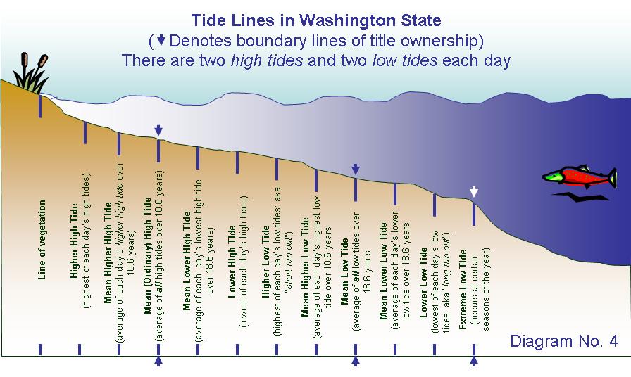
14 Tidelands Puget Sound, ocean and certain rivers subject to ebb and flow of tides Some conveyed to private owners. If so: Separate chain of title from adjoining uplands But included in the legal description If not conveyed by State, still in State Ownership Boundary is line of ordinary high tide
15 TIDELANDS


16 2 Shorelands Beds of navigable waters: applies to lakes, rivers, streams State owns since 1/11/1889
17 Shorelands Lakes, rivers, streams not subject to tidal flow - but navigable Some conveyed to private owners. If so: Separate chain of title from adjoining uplands But must be included in the legal description Unless conveyed by State, still in State Ownership Boundary is Line of ordinary high water

18 FIRST CLASS TIDELANDS & SHORELANDS
19 3 - Bed of non- navigable bodies of water Applies to small lakes & streams Title not in State Title included in uplands description without mentioning it
20 4 - Land beyond the outer limits of tidelands or shorelands (line of navigability) cannot be in private fee ownership portions (harbor areas) can be leased from the State
21 TITLE EXCEPTIONS These exceptions apply across the state Not just limited to the wet side of the mountains
22 TITLE EXCEPTIONS The nature of the land determines what exceptions we show in our commitments and policies And the description might not mention water
23 TITLE EXCEPTIONS Some deal with TITLE to submerged land Others deal with BOUNDARY questions Others deal with USE questions
24 TITLE EXCEPTIONS They are shown because: We don t know and We don t care
25 1 Public and Private Riparian Rights Any prohibition or limitation on the use, occupancy, or improvements of the land resulting from the rights of the public or riparian owners to use any waters which may cover the land or to use any portion of the land which is now or may formerly have been covered by water. USE of submerged (or formerly submerged) land Includes Public Trust Doctrine
26 1 Public and Private Riparian Rights Covers, among other things rights of downstream owners to water that crosses upstream riparian land Rights of other owners to use the surface of the water (Bitter Lake) Rights of the public to use the surface (Lake Chelan) rights of the state to regulate uses of tidelands, shorelands and adjoining uplands under the Shoreline Management Act ( public trust ) Shown whether standard coverage or extended coverage
27 1 Public and Private Riparian Rights tidelands shorelands land between high tide and seaward meander line if patent before statehood current or former lake beds, navigable or not current or former beds of rivers, streams or sloughs, navigable or not harbor areas uplands abutting such lands oyster lands When to show
28 PUBLIC TRUST DOCTRINE Government authority to protect the public interest, and regulate development, commerce, navigation and environmental protection essentially, zoning tidelands & shorelands wetlands uplands within 200 feet of these lands
29 PRIVATE RIPARIAN RIGHTS Abutting upland owner is a riparian owner In addition to any title to the bed Riparian owner has right, along with all riparian owners to reasonable use of the surface of a lake Riparian rights of abutters are owned in common Thus: each upland owner can use entire surface of lake not just the area over the bed owned by the riparian abutter
30 RIGHTS OF THE PUBLIC General public has rights to use the surface of water for recreational purposes Title insurers take exception to such rights, whether navigable or non-navigable
31 2 State of Washington ownership Rights of the State of Washington in and to that portion of said premises, if any, lying in the bed or former bed of the [insert the name of the body of water], if it is navigable. TITLE exception affects riparian or littoral land abutting or under navigable water
32 2 State of Washington ownership TITLE exception riparian land Navigable water flows through, covers, or adjoins the insured property Can delete if water adjudicated nonnavigable Applies even if stream is boundary Applies to current, former or future bed

33 STATE OWNERSHIP
34 3 River or Stream Boundary Any question that may arise due to shifting or change in the course of the [insert the name of the body of water] or due to the [insert the name of the same body of water] having shifted or changed its course. BOUNDARY (survey) exception applies to riparian land
35 3 River or Stream Boundary BOUNDARY exception Similar to the general survey exception in standard coverage policies But never deleted even in extended coverage title policy Applies when description ties to either the thread or the bank of a river, stream, brook, creek, etc. All water Navigable or non-navigable
36 3 River or Stream Boundary Doesn t make any difference whether the boundary is the center of the river or stream, or the high water mark
37 3 River or Stream Boundary If change in river is natural but avulsive (sudden), and/or man-made then: Original (not current) location of river may be property boundary Land might no longer touch the water, or The water could be farther away from the property, or entirely within the property lines
38 3 River or Stream Boundary If change in river is gradual Boundaries of parcels on either side of the river may shift with the movement of the river Insurer will not insure exact location of the water, nor whether it has moved or might move in the future, nor the nature of any past movement
39 CHANGES IN WATER BOUNDARIES

40 CHANGES IN WATER BOUNDARIES

41 CHANGES IN WATER BOUNDARIES
42 Original Location GL 1 GL 2 NW/NW
43 GL 1 or NW/NW? GL 1 GL 2 NW/NW New Location (gradual)
44 GL 1? Or GL 2? or NW/NW? or w/adjoining? GL 1 GL 2 gone? Forever?? NW/NW New Location (gradual)
45 GL 1? GL2? NW/NW? GL 1 Gone? Forever? Or way east? GL 2 gone? Forever? Or way east? NW/NW gone? Forever?? Or way east? New Location (gradual)
46 You can t go back again or can you? GL 1? GL 1? Or GL 2? Or NW/NW? Are these recreated?? Newer new many years later location (gradual)
47 4 Lake, Sound, Bay or Ocean Boundary Any questions that may arise due to shifting or change of the line of high water of the [insert the name of the body of water] or due to the [insert the name of the same body of water] having shifted or changed its line of high water. BOUNDARY (survey) exception applies to riparian or littoral land
48 4 Lake, Sound, Bay or Ocean Boundary BOUNDARY (survey) exception Not removed for extended coverage title policies Similar to Exception 2 (rivers) but usually because of reliction and maybe accretion Shown if land bounded by lake or similar body water
49 4 Lake, Sound, Bay or Ocean Boundary Applies to uplands only, or uplands with submerged lands (shorelands), or submerged lands (shorelands) only Whether or not the description mentions body of water
50 5 Lateral Boundaries of Submerged Lands Any question that may arise as to the location of the lateral boundaries of the [tidelands] [shorelands] described herein. BOUNDARY (survey) exception applies to tidelands or shorelands that are included in the legal description
51 5 Lateral Boundaries of Submerged Lands BOUNDARY (survey) exception Added as special exception if tidelands or shorelands are in description Example: together with the tidelands of the second class adjoining.
52 5 Lateral Boundaries of Submerged Lands Assessor s maps or surveys not reliable Exception can be deleted if adjoining owners mutually establish boundary, or submerged lands platted if plattor owned all State platted tidelands or shorelands. Caution with older plats
53 LATERAL LINES No title insurance on location of lateral lines unless court decree establishes lines presumably confirming the title of each owner on either side of the lines, or a plat created by a common owner, or an agreement between adjoining owners establishes lateral boundaries including mutual conveyance between the owners confirming title according to agreed upon boundaries
54 LATERAL LINE BOUNDARIES ON LAKES
55 NON-NAVIGABLE LAKES REMEMBER All water assumed navigable Even if unless court determines otherwise the body of water is not shown on the Government Survey, and/or no meander lines were shown on that survey, and/or the adjoining uplands are not described as government lots So title insurance will presume the State owns the bed
56 NON-NAVIGABLE LAKES As to the beds of known nonnavigable lakes: they are submerged lands but are not shorelands, and State has no interest (title) in them Such beds owned by the adjoining property owners
57 NON-NAVIGABLE LAKES If all land surrounding a small, nonnavigable lake owned by one person that person also owns the bed of the lake If multiple owners around the lake the rules for lateral lines are not clearly drawn by court decisions as they have been for tidelands and shorelands
58 NON-NAVIGABLE LAKES Property owners may agree to each own an undivided interest in the entire lake, or divide the bed of round lakes by making pieshaped connections to the center of the lake Each with title to abutting pie-shaped parcel of the bed See Diagram No. 10 BUT AGAIN: No title insurance as to the location of lateral lines

59 LATERAL LINES Round Lake
60 NON-NAVIGABLE LAKES Property owners may Divide the bed of non-round lakes in common sense allocation of beds using center lines along the long lengths of the lake Example: See Diagram No. 11 BUT AGAIN: No title insurance as to the location of lateral lines

61 LATERAL LINES Odd-Shaped Lake
62 LATERAL LINES How do property lines extend out into owned shorelands? These boundaries commonly called lateral lines may have no relationship to the boundaries of the upland parcel Owner cannot unilaterally project the upland boundaries out into the shorelands
63 LATERAL LINES No statutes defining the direction of lateral lines through shorelands No helpful language in the original deeds from State State deeds simply convey all shorelands Example: all shorelands of the second class lying in front of and abutting Government Lot 3, Section [ ], Township [ ] North, Range [ ] East, W.M.
64 LATERAL LINES What rules might apply? Decisions by State Supreme Court interpreting word abutting The basic rule beach is a relatively straight line Lateral lines are projected into the water at right angles to the line of ordinary high water See Diagram No. 7

65 LATERAL LINES Diagram No. 7
66 LATERAL LINES - COVE Different rule Right angle rule is not equitable division Example: Connect property line at shore line to proportionate lengths of frontage at line of navigability See Diagram No. 8

67 LATERAL LINES COVE
68 LATERAL LINES PLAT Owner of submerged land can subdivide and delineate specific locations of the interior lateral lines in any manner Example in Diagram No. 9 BUT exterior boundary lines (either end of entire submerged parcel) cannot be fixed without agreement and conveyance involving adjoining submerged land owners

69 LATERAL LINES PLAT
70 BOUNDARIES ON STREAMS
71 NON-NAVIGABLE STREAMS REMEMBER All water assumed navigable Even if unless court determines otherwise the body of water is not shown on the Government Survey, and/or no meander lines were shown on that survey, and/or the adjoining uplands not described as government lots So title insurance will presume State owns the bed
72 NON-NAVIGABLE STREAMS Boundary line between two properties divided by non-navigable stream unless the descriptions clearly recite otherwise! is the thread of that stream Bed owned by the abutting uplands owners whether or not it also constitutes a boundary between separate ownerships Not vested in the State of Washington
73 ISLANDS Present special problems - especially in rivers and sloughs Might be shown on the original Government Survey as government lots Elusive boundaries Or might have been created after Government Survey Title presumed in State (bed of river navigable) May not be possible to describe constant accretion and reliction action
74 Section Line Clover Island
75 Section Line ISLANDS Government Survey No. 1
76 Section Line Government Survey No. 2
77 ISLANDS Additional problems Dam built downstream Land condemned (fee or easement) for raising the river How is the land described?
78 Water Level Lowers GL 1 Which Gov Lot is the island in? 1 or 2? GL 2
79 GL 1 GL 2 Which Gov Lot is the island in? 1 or 2? River moves
80 Other exceptions: 6. Navigation Rights 7. Reservations and Reversions 8. Water and Water Rights 9. Certificates of Water Rights

81 NAVIGABILITY
82 NAVIGABILITY Navigability determined on Statehood November 11, 1889 THUS: Current appearance of a stream or lake (even dried up) does not determine status If navigable at the date of statehood, the bed (or former bed) was and is owned by the State Definition? Common misconceptions
83 NAVIGABILITY Title insurers presume: navigability of all water, and the bed therefore owned by the State unless a court determines otherwise
84 NAVIGABILITY 1. Meander line = navigable NOT SO! Meander lines laid out solely to comply with the requirements of the US Rectangular Survey Act A lake of more than 25 acres, or A stream of over 198 feet in width WHETHER OR NOT NAVIGABLE!
85 NAVIGABILITY 2. State has issued deeds for shorelands on a particular lake = navigable NOT SO! DNR takes position: Supreme Court determination needed Has issued deeds for shorelands on small lakes and rivers before court determination
86 NAVIGABILITY 3. A stream floats logs = navigable NOT SO! A case does provide that stream which floats logs is navigable for that purpose BUT it does not follow that stream is capable of commercial navigation the bed of such a stream does not necessarily belong to the State
87 Accretion ACCRETION AND RELICTION build-up of soil deposited on one bank forces the water to move, or shift, its location Reliction gradual movement of water erosion of land on one bank exposes formerly submerged land on the other bank
88 ACCRETION AND RELICTION Gradual shift changes location boundary between two parcels River or stream (navigable or nonnavigable) could shift its location have already shifted its location So: title can t be insured without an exception See Diagram No. 5.
89 ACCRETION AND RELICTION Same natural processes apply to tidelands on the Ocean Puget Sound or rivers emptying into them shorelands on a river or lake
90 ACCRETION AND RELICTION General rule Accretion or reliction shifts the boundary between the upland parcel and the submerged land Thus, newly added or exposed land becomes part of upland parcel BUT - accretions, even abutting previously sold submerged lands, are still claimed by the State (willing to sell to the abutting private owner
91 ACCRETION AND RELICTION No title insurance as to boundaries between uplands and submerged lands, nor Title to exposed land, nor whether movement was avulsive or gradual Even newly permanently created or exposed lands are claimed by State Theory: Title of the underlying submerged land was vested in the State, so accretion or reliction does not divest that title
92 AVULSION Stream changes or shifts location suddenly natural event (earthquake, landslide, etc.) or man-made activity construction of dam, or re-channeling of river the property lines normally do not shift Each owner continues to own to the original location of their property boundaries See Diagram No. 6.
93 AVULSION EXAMPLE Dam construction covers land with water Land must be conveyed by the owner fee or easement or taken by condemnation.
94 AVULSION No title insurance as to boundaries between uplands and submerged lands, nor Title to exposed land, nor whether movement avulsive or gradual This is the same as with accretion or reliction
Washington Land Title Association Examiner s Manual WATERFRONT TITLES In the State of Washington. Contents
 WATERFRONT TITLES In the State of Washington Contents 1.0 INTRODUCTION...2 2.0 GOVERNMENT SURVEY...3 3.0 GOVERNMENT LOT BOUNDARIES...3 4.0 PATENTS BEFORE STATEHOOD...3 5.0 PATENTS AFTER STATEHOOD...4 6.0
Water Rights: Beds, Boats & Beaches
 Water Rights: Beds, Boats & Beaches James W. Williams III Chicago Title Insurance Co. 3/16/2005 Chicago Title 1 Introduction Public Trust Doctrine & Submerged Lands Federal Navigational Servitude Who Owns
Title Transfer. When the title changes hands, this is called alienation.
 Transfer 1 Title Transfer When the title changes hands, this is called alienation. 2 Involuntary Alienation Involuntary Transfer of Title Without the owner s consent. 3 Involuntary Transfer of Title The
California Land Surveyors Association
 1 California Land Surveyors Association 2 Introduction 2012 LS REVIEW Water Boundaries March 27, 2012 What are boundaries is a matter of law; where they are is a matter of fact Justice Wheeler, 1856 Today
California Land Surveyors Association
 California Land Surveyors Association 2012 LS REVIEW Water Boundaries March 27, 2012 1 Introduction What are boundaries is a matter of law; where they are is a matter of fact Justice Wheeler, 1856 Today
12/10/2012. Ohio Presentation 2013 Kristopher M. Kline, P.L.S., G.S.I.
 Ohio Presentation 2013 Kristopher M. Kline, P.L.S., G.S.I. kkline@buncombe.main.nc.us When one thinks about ownership of property along waterways, one may break down the impact of "navigability" in three
Preparing Property descriptions D A V I D T. BUTCHER, PLS
 Preparing Property descriptions D A V I D T. BUTCHER, PLS Who can prepare property descriptions? 327.272. Practice as professional land surveyor defined. 1. A professional land surveyor shall include any
DATE: September 10, 2013 RE: Seawall Review - Park Shore - Preliminary Legal and Title Review Report
 TO: FROM: CC: Hon. John F. Sorey III, Mayor & Naples City Council Stephen E. Thompson & Robert D. Pritt A. William Moss, City Manager DATE: September 10, 2013 RE: Seawall Review - Park Shore - Preliminary
THE COUNTY BOARD OF SUPERVISORS OF THE COUNTY OF DOUGLAS DOES ORDAIN AS FOLLOWS:
 8.1 SUBDIVISION CONTROL ORDINANCE THE COUNTY BOARD OF SUPERVISORS OF THE COUNTY OF DOUGLAS DOES ORDAIN AS FOLLOWS: SECTION I. GENERAL INTERPRETATION This ordinance shall not repeal, impair or modify private
Some Social and Policy Implications of Shore Erosion. James G. Titus U.S. Environmental Protection Agency
 Some Social and Policy Implications of Shore Erosion James G. Titus U.S. Environmental Protection Agency Four copyrighted photos included in briefing as fair use Deleted because duplication may violate
Survey and Recording Requirements
 Article C: Sec. 14-1-40 Survey and Recording Requirements Survey Requirements. (a) (b) (c) Prior to the final approval of land divisions to which this Chapter applies, the owner of the land shall have
Circuit Court, D. Nebraska. March 1, 1889.
 EAST OMAHA LAND CO. V. JEFFRIES. Circuit Court, D. Nebraska. March 1, 1889. 1. BOUNDARIES ACCRETIONS CONVEYANCE. Rev. St. U. S. 2396, provides that the boundaries and contents of the several sections,
INCOMPLETE APPLICATIONS WILL BE RETURNED! GENERAL PROPERTY INFORMATION. Applicant s name Day Phone address Authorized Agent (if applicable)
") Environmental Services Planning & Zoning 601 Third Avenue Two Harbors, MN 55616 www.co.lake.mn.us (218)834-8327 Fax: (218)-834-8365 LAKE COUNTY ADMINISTRATIVE SUBDIVISION APPLICATION PLEASE COMPLETE IN
Environmental Services Planning & Zoning 601 Third Avenue Two Harbors, MN 55616 www.co.lake.mn.us (218)834-8327 Fax: (218)-834-8365 LAKE COUNTY ADMINISTRATIVE SUBDIVISION APPLICATION PLEASE COMPLETE IN
BOUNDARY SURVEYS RE-SURVEYS
 BOUNDARY SURVEYS RE-SURVEYS One of the difficult tasks for a surveyor is the re-surveying of lands, the re-location of the boundary lines between privately-owned lands or the re-location of the boundary
Introduction Riparian Rights are rights of use There is no absolute property interest can be acquired in flowing water : Introduction
 Laura E. Ayers, Esq. The Law Office of Laura E. Ayers, Esq. 223 Church Street Fultonville, NY 12072 (518) 922-5086 www.lauraayerslaw.com Introduction Riparian Rights are rights of use There is no absolute
CONFLICTING ELEMENTS
 CONFLICTING ELEMENTS Order of importance of conflicting elements that determine land location: A. Unwritten rights. B. Senior right. C. Written intentions of Parties. D. Lines Marked and Run. E. Natural
Competing Rights to our Natural Resources and Privileges to the Shore March 30, 2016
 Competing Rights to our Natural Resources and Privileges to the Shore March 30, 2016 Prof. Dennis Esposito Director Environmental and Land Use Clinical Externship Program; Adjunct Prof. Marine Affairs
1/9/2019. Northwest Ordinance An Ordinance for the government of the Territory of the United States northwest of the River Ohio.
 Wisconsin the land of over 9,000 Lakes covering over 11,000 square miles! (in a state with about 65K square miles at least according to our friends at Google) Cheri Hipenbecker, Knight Barry Title Group,
SURVEYING BOUNDARIES FORESHORE AND PROPERTY OUTLINE DEFINITIONS JURISDICTIONAL ISSUES TENURE ISSUES PRACTICAL SURVEY ISSUES RECOMMENDATIONS
 SURVEYING BOUNDARIES OUTLINE DEFINITIONS JURISDICTIONAL ISSUES TENURE ISSUES PRACTICAL SURVEY ISSUES RECOMMENDATIONS DEFINITIONS FORESHORE: the part of the seashore between the high water mark and the
Invoice Date: May 2, Operation: END Additional Chain Charge
 WT04087 Remit Payment To: Western Title & Escrow Company Third Avenue, Suite 30 INVOICE Seattle, WA 980 Phone: (54)65-88 Fax: (54)65-9570 Due upon receipt City of Lincoln City,Urban Renewal Agency 80 SW
Sovereignty Submerged Lands Management in the State of Florida
 Sovereignty Submerged Lands Management in the State of Florida What are Sovereign Submerged Lands? Lands that Florida took ownership to by virtue of its sovereignty upon becoming a state in 1845. Through
NORTH CAROLINA PROPERTY MAPPERS ADVANCED MAPPING CONVEYANCES AND OTHER DATA SOURCES
 NORTH CAROLINA PROPERTY MAPPERS SECTION 10 CONVEYANCES AND OTHER DATA SOURCES 10-1 10.1 Real Estate vs Real Property The terms real estate and real property are often used to describe the same thing, but
SOURCES OF TITLE I. [ 1.1] SCOPE II. [ 1.2] INTRODUCTION
![SOURCES OF TITLE I. [ 1.1] SCOPE II. [ 1.2] INTRODUCTION](/thumbs/95/122993064.jpg "SOURCES OF TITLE I. [ 1.1] SCOPE II. [ 1.2] INTRODUCTION") RONALD A. KRISS* SHARON CHRISTENBURY** 1 SOURCES OF TITLE I. [ 1.1] SCOPE II. [ 1.2] INTRODUCTION III. PRIMARY SOURCES OF TITLE A. [ 1.3] In General B. [ 1.4] Legislative Grants C. [ 1.5] Spanish Grants
RONALD A. KRISS* SHARON CHRISTENBURY** 1 SOURCES OF TITLE I. [ 1.1] SCOPE II. [ 1.2] INTRODUCTION III. PRIMARY SOURCES OF TITLE A. [ 1.3] In General B. [ 1.4] Legislative Grants C. [ 1.5] Spanish Grants
Local units of government control the use of private
 9 Land Use REEB 24.085 Chapter Overview Land use issues are one of the hottest topics in the area of real estate. This chapter outlines the basics of land use regulation. Important Terminology conditional
Chapter 7 Questions Interests in Real Estate
 Chapter 7 Questions Interests in Real Estate 1. A statutory right that a family has in its residence is called a. entirety. b. survivorship. c. curtesy. d. homestead. 2. A person who has complete control
Physical Encumbrances
 Physical Encumbrances Types of physical encumbrances include (1) deed restrictions, (2) easements, and (3) encroachments. D eed restrictions A major package of private deed restriction are covenants, conditions
OUTSHORE BOUNDARIES. Publication Date: January 2012
 GUIDE TO OUTSHORE BOUNDARIES Publication Date: January 2012 Last Revision Date: July 2015 to update cover pages. New York State Association of Professional Land Surveyors 2016 Annual Conference Turning
Florida Department of Environmental Protection Florida s State Lands Authorizations
 Florida Department of Environmental Protection Florida s State Lands Authorizations Andrew J. Baumann, Esq. Kelly Samek, Senior Assistant General Counsel Sovereign Submerged Lands Lands under navigable
Application for Use of State-owned Aquatic Lands
 s Applicant Name: Taylor Shellfish Co. Inc County: Mason County Water Body: North Bay Type of Authorization - Use: Right of Entry Aquaculture Authorization Number: 23-085711 Term: 5 years Description:
ARTICLE 3 DEFINITIONS
 Sections: 3-1 Rules of Construction 3-2 Definitions ARTICLE 3 DEFINITIONS SECTION 3-1 RULES OF CONSTRUCTION 3-101. a. The language set forth in these regulations shall be interpreted in accordance with
SENATE, No STATE OF NEW JERSEY. 217th LEGISLATURE INTRODUCED SEPTEMBER 8, 2016
 SENATE, No. 0 STATE OF NEW JERSEY th LEGISLATURE INTRODUCED SEPTEMBER, 0 Sponsored by: Senator BOB SMITH District (Middlesex and Somerset) Senator CHRISTOPHER "KIP" BATEMAN District (Hunterdon, Mercer,
WATER 101: WATER RIGHTS
 WATER 101: WATER RIGHTS Water Education Foundation February 22, 2018 Professor Jennifer Harder McGeorge School of Law jharder@pacific.edu The lifeblood of the state WATER RIGHTS PHYSICAL CATEGORIES Surface
BUSI 352. Review & Discussion Questions: Answer Guide 7. Lesson 7: Appraising Waterfront Residential Properties Review & Discussion Questions
 BUSI 352 Review & Discussion Questions: Answer Guide 7 Lesson 7: Appraising Waterfront Residential Properties Review & Discussion Questions 1. (a) The natural boundary is the property line for properties
REAL PROPERTY INTERESTS
 REAL PROPERTY INTERESTS Real and Personal Property In most instances the surveyor's concern of differences between real and personal property is of minimal interest, but to his client these differences
Standards of Practice for Surveying in the State of Alabama
 Standards of Practice for Surveying in the State of Alabama Effective January 1, 2017 RULE NO. 1.01 PURPOSE The purpose of these rules is to establish standards for the practice of surveying in the State
Condominiums They re Baaaaack! (Well, back to haunt us)
") Condominiums They re Baaaaack! (Well, back to haunt us) Unusual Issues in the Current Market 2016 WLTA Fall Education Seminars Spokane (Sept 24) & Lynnwood (Oct 15) David E. Lawson Fidelity National Title
Condominiums They re Baaaaack! (Well, back to haunt us) Unusual Issues in the Current Market 2016 WLTA Fall Education Seminars Spokane (Sept 24) & Lynnwood (Oct 15) David E. Lawson Fidelity National Title
Michigan Lake & Stream Associations 2016 Annual Convention. Clifford H. Bloom, Esq. Bloom Sluggett Morgan, PC (616)
") Michigan Lake & Stream Associations 2016 Annual Convention Clifford H. Bloom, Esq. Bloom Sluggett Morgan, PC (616) 965-9342 www.bsmlawpc.com Definitions Riparian Littoral When is Land Riparian? Must touch
Michigan Lake & Stream Associations 2016 Annual Convention Clifford H. Bloom, Esq. Bloom Sluggett Morgan, PC (616) 965-9342 www.bsmlawpc.com Definitions Riparian Littoral When is Land Riparian? Must touch
LEGAL CONSIDERATIONS IN APPRAISAL (from:
 Chapter 1: PROPERTY AND LEGAL DESCRIPTIONS The first thing an appraiser must determine is what property rights are being appraised. At the beginning of any discussion about property, it is important to
GENESEE VALLEY LAND SURVEYORS ASSOCIATION MINIMUM STANDARDS FOR A MAP OF A SURVEY. Effective Date: February 15, 2017
 GENESEE VALLEY LAND SURVEYORS ASSOCIATION MINIMUM STANDARDS FOR A MAP OF A SURVEY Effective Date: February 15, 2017 1. The Land Surveyor shall perform due diligence in their research, maintain proper documentation
FREQUENTLY USED PLANNING & ZONING TERMS
 City Of Mustang FREQUENTLY USED PLANNING & ZONING TERMS Abut: Having property lines, street lines, or zoning district lines in common. Accessory Structure: A structure of secondary importance or function
ARTICLE 23 CONDOMINIUM STANDARDS
 ARTICLE 23 CONDOMINIUM STANDARDS Section 23.01 Intent. The intent of this Article is to provide regulatory standards for condominiums and site condominiums similar to those required for projects developed
Ministry of Forest, Lands and Natural Resource Operations
 WHEREAS: PROVINCIAL GENERAL PERMISSION FOR THE USE OF CROWN LAND FOR PRIVATE MOORAGE VERSION: January 17, 2017 (Land Act) A. The Ministry of Forests, Lands and Natural Resource Operations ( the Ministry
TO: Glynn County Islands Planning Commission. Eric Landon, Planner II. PP2754 Stones Throw Cottages. DATE: February 6, 2014
 COMMUNITY DEVELOPMENT DEPARTMENT Planning and Zoning Division 1725 Reynolds Street, Suite 200, Brunswick, GA 31520 Phone: 912-554-7428/Fax: 1-888-252-3726 TO: Glynn County Islands Planning Commission FROM:
2017_10_MIKES_SWEETMAN_OE_PC.PDF
 1. OCTOBER PLANNING COMMISSION AGENDA Documents: OCTOBER 2017.PDF 1.I. MIKES/SWEETMAN OUTRIGHT EXEMPTIONS Documents: 2017_10_MIKES_SWEETMAN_OE_PC.PDF DEPARTMENT OF PLANNING AND ZONING 308 Byers Ave P.O.
Purpose and History of the State Lands Commission
 Purpose and History of the State Lands Commission And more importantly. A Valuable Resource for the Boundary Surveyor 1 The State Lands Commission Is: Made up of Lieutenant Governor Gavin Newsom State
PRELIMINARY DECISION
 STATE OF ALASKA DEPARTMENT OF NATURAL RESOURCES DIVISION OF MINING, LAND AND WATER PRELIMINARY DECISION Kodiak Island Borough Application for Lease AS 38.05.810(a) This (PD) is the initial determination
M E M O R A N D U M Florida Legislative Session Bills of Concern CS/HB 631 (Chapter Law ) Customary Use and Beach Access
 Customary Use and Beach Access") THOMAS J. TRASK, B.C.S.* JAY DAIGNEAULT RANDY MORA ERICA F. AUGELLO JOHN E. SCHAEFER DAVID E. PLATTE PATRICK E. PEREZ ROBERT M. ESCHENFELDER, B.C.S.* * Board Certified by the Florida Bar in City, County
THOMAS J. TRASK, B.C.S.* JAY DAIGNEAULT RANDY MORA ERICA F. AUGELLO JOHN E. SCHAEFER DAVID E. PLATTE PATRICK E. PEREZ ROBERT M. ESCHENFELDER, B.C.S.* * Board Certified by the Florida Bar in City, County
Railroads & Title Insurance Issues. Dave Lawson, Fidelity National Title Group
 Railroads & Title Insurance Issues Dave Lawson, Fidelity National Title Group Title - currently or formerly in a Railroad? What s the true nature of their ownership? What was first, the railroad or the
Question 7: Titles in and adjacent to the marine and coastal area
 19 October 2010 Māori Affairs Committee Marine and Coastal Area (Takutai Moana) Bill Question 7: Titles in and adjacent to the marine and coastal area On 13 October, the Committee asked for: Advice on
CONDOMINIUMS. If the condominium declaration has been amended, add: AS AMENDED FROM TIME TO TIME. INTEREST" language. Condominiums 7/2000 Rev 10/2001
 CONDOMINIUMS The condominium method of holding the fee simple title to real property consists in the outright and exclusive ownership of a unit as well as ownership in common with others of an undivided
ORDINANCE NO WHEREAS, the Town of Jupiter ( Town ) has adopted a Comprehensive Plan
 has adopted a Comprehensive Plan") 0 0 ORDINANCE NO. -0 AN ORDINANCE OF THE TOWN COUNCIL OF THE TOWN OF JUPITER, FLORIDA, AMENDING CHAPTER OF THE TOWN CODE TO AMEND SECTION -, ENTITLED INTENT TO ADD PERMITTING LANDGUAGE; TO AMEND SECTION
0 0 ORDINANCE NO. -0 AN ORDINANCE OF THE TOWN COUNCIL OF THE TOWN OF JUPITER, FLORIDA, AMENDING CHAPTER OF THE TOWN CODE TO AMEND SECTION -, ENTITLED INTENT TO ADD PERMITTING LANDGUAGE; TO AMEND SECTION
To provide for the review of the final engineering plans, the subdivision improvement agreement, public dedications, and other legal agreements.
 ARTICLE 5 FINAL PLAT 501 Intent DOUGLAS COUNTY SUBDIVISION RESOLUTION To provide for the review of the final engineering plans, the subdivision improvement agreement, public dedications, and other legal
PRELIMINARY DECISION. For an Interagency Land Management Assignment ADL at. to the Department of Natural Resources, Division of Forestry
 PRELIMINARY DECISION For an Interagency Land Management Assignment ADL 108262 at to the Department of Natural Resources, Division of Forestry I. Requested ILMA February 25, 2016 The applicant, the Department
ARTICLE 5 MINOR SUBDIVISION/LAND DEVELOPMENT
 ARTICLE 5 MINOR SUBDIVISION/LAND DEVELOPMENT SECTION 501 ONLY FINAL PLAN REQUIRED The classification of a proposed subdivision as a "Minor Subdivision" shall only require the submission, review and approval
Alabama State Lands Division Submerged Lands Permitting
 ALABAMA DEPARTMENT OF CONSERVATION AND NATURAL RESOURCES Alabama State Lands Division Submerged Lands Permitting Placement and Configuration or Piers and other Improvements On State Submerged Lands Jurisdiction
SUBDIVISION BY-LAW MUNICIPALITY OF THE COUNTY OF INVERNESS
 SUBDIVISION BY-LAW MUNICIPALITY OF THE COUNTY OF INVERNESS APPROVED BY COUNCIL: JUNE 15, 1998 EFFECTIVE DATE: SEPTEMBER 23, 1998 Page 2 TABLE OF CONTENTS PART 1: SHORT TITLE... 5 PART 2: INTERPRETATION...
DRAFT MEMORANDUM OF UNDERSTANDING
 DRAFT MEMORANDUM OF UNDERSTANDING BETWEEN COUNTY OF MARIN AND SAN RAFAEL AIRPORT, LLC This Memorandum of Understanding (MOU) made and entered into this day of, 2017, by and between the County of Marin,
Chapter 19. Water, Riparian, and Foreshore Rights. Key Terms. Water Rights. Riparian Rights. Chapter 19: Water, Riparian, and Foreshore Rights
 207 Chapter 19 Water, Riparian, and Foreshore Rights This chapter provides some basic background information and lists resources for research projects relating to water, riparian and foreshore rights.
P.F. WOOD, APPELLANT, V. C. MANDRILLA, RESPONDENT. SAC. NO SUPREME COURT
 Supreme Court of California,Department Two. 167 Cal. 607 {Cal. 1914) WOOD V. MANDRILLA P.F. WOOD, APPELLANT, V. C. MANDRILLA, RESPONDENT. SAC. NO. 2089. SUPREME COURT OF CALIFORNIA,DEPARTMENT TWO. APRIL
WYANDOT COUNTY BASIC STANDARDS FOR THE APPROVAL OF REAL ESTATE DEED TRANSFERS & LAND CONTRACT AGREEMENTS
 GENERAL In compliance with Section 315.251 of the Ohio Revised Code, the County Auditor and the County Engineer have adopted these written standards governing the conveyance of real property in Wyandot
ALASKA DEPARTMENT OF NATURAL RESOURCES DIVISION OF MINING, LAND AND WATER MUNICIPAL ENTITLEMENT
 I. PROPOSED ACTION ALASKA DEPARTMENT OF NATURAL RESOURCES DIVISION OF MINING, LAND AND WATER MUNICIPAL ENTITLEMENT PRELIMINARY DECISION CONVEYANCE OF TIDE AND SUBMERGED LAND UNDER AS 38.05.825 MATANUSKA-SUSITNA
ARTICLE XI - CONSERVATION SUBDIVISIONS
 ARTICLE XI - CONSERVATION SUBDIVISIONS Section 1101: Purpose and Intent. This Article is intended to provide for residential subdivisions that are designed based first and foremost on the preservation
******************************************************************************
 AGENDA BOARD OF TRUSTEES OF THE INTERNAL IMPROVEMENT TRUST FUND MARCH 19, 2013 Attachments to the items below can be viewed at the following link: http://www.dep.state.fl.us/secretary/cab/public_notices.htm
OWNERSHIP (REAL PROPERTY CHARACTERISTICS, DEFINITIONS, OWNERSHIP, RESTRICTIONS, AND TRANSFER) PERSONAL PROPERTY (personalty or chattel)
 PERSONAL PROPERTY (personalty or chattel)") OWNERSHIP (REAL PROPERTY CHARACTERISTICS, DEFINITIONS, OWNERSHIP, RESTRICTIONS, AND TRANSFER) Property is everything subject to ownership (also known as title). Tangible (corporeal) means physical items
OWNERSHIP (REAL PROPERTY CHARACTERISTICS, DEFINITIONS, OWNERSHIP, RESTRICTIONS, AND TRANSFER) Property is everything subject to ownership (also known as title). Tangible (corporeal) means physical items
CHAPTER FOUR REAL ESTATE TABLE OF CONTENTS
 CHAPTER FOUR REAL ESTATE LAW TABLE OF CONTENTS 1) LEGAL PRINCIPLES OF A CONTRACT PAGE 2 2) CLASSIFICATION OF CONTRACTS PAGE 9 3) LEGAL EFFECT OF A CONTRACT PAGE 13 4) CHANGES IN CONTRACTS PAGE 17 5) OPTIONS/RIGHT
ATTORNEYS' TITLE FUND SERVICES, LLC Tampa Bay Branch 9014 Brittany Way. Tampa, FL (813) Fax: (866)
 Fax: (866)") ATTORNEYS' TITLE FUND SERVICES, LLC Tampa Bay Branch 9014 Brittany Way Tampa, FL 33619 (813) 740-1900 Fax: (866) 328-1884 Mechanik Nuccio Hearne & Wester Date: January 27, 2016 305 South Boulevard Fund
ATTORNEYS' TITLE FUND SERVICES, LLC Tampa Bay Branch 9014 Brittany Way Tampa, FL 33619 (813) 740-1900 Fax: (866) 328-1884 Mechanik Nuccio Hearne & Wester Date: January 27, 2016 305 South Boulevard Fund
Tidelands Act. UPDATED THROUGH P.L. 2016, ch.32, and JR 3 of 2016
 Tidelands Act UPDATED THROUGH P.L. 2016, ch.32, and JR 3 of 2016 12:3-1 Commissioners to make survey and report as to riparian lands, etc. P.L.1864, c. 391, p. 681 (Rev.1877, pp. 981, 982, s.s. 1 to 6;
Rising Tides-Changing Title: Walton County v. Stop the Beach Renourishment
 Pace University DigitalCommons@Pace Pace Law Faculty Publications School of Law 2009 Rising Tides-Changing Title: Walton County v. Stop the Beach Renourishment John R. Nolon Elisabeth Haub School of Law
Construction & Earthwork Request Form (CERF)
") ShoreLand Traditions Construction & Earthwork Request Form (CERF) SECTION 1 SECTION 2 SECTION 3 Definitions and Points to Remember Requirements and Process Site Sketch Requirements and Sample If you have
ShoreLand Traditions Construction & Earthwork Request Form (CERF) SECTION 1 SECTION 2 SECTION 3 Definitions and Points to Remember Requirements and Process Site Sketch Requirements and Sample If you have
Chesapeake Bay Preservation Area (CBPA) Map Update. Presentation to the County Board July 15, 2017
 Map Update. Presentation to the County Board July 15, 2017") Chesapeake Bay Preservation Area (CBPA) Map Update Presentation to the County Board July 15, 2017 Chesapeake Bay Program Comprehensive Plan Chesapeake Bay Preservation Ordinance (1992) (Chapter 61, Arlington
Chesapeake Bay Preservation Area (CBPA) Map Update Presentation to the County Board July 15, 2017 Chesapeake Bay Program Comprehensive Plan Chesapeake Bay Preservation Ordinance (1992) (Chapter 61, Arlington
APPLICATION TO CLOSE AND CONVEY SHORE ROAD ALLOWANCES
 APPLICATION TO CLOSE AND CONVEY SHORE ROAD ALLOWANCES BACKGROUND: Council is prepared to consider applications to close and convey unopened shore road allowances. This involves a number of legal procedures
Open Space Model Ordinance
 Open Space Model Ordinance Section I. Background Open space development has numerous environmental and community benefits, including: 1) Reduces the impervious cover in a development. Impervious cover
Methods of Legal Description Metes and Bounds The Rectangular Survey System Recorded Plat Method Describing Elevation
 9 Legal Descriptions Methods of Legal Description Metes and Bounds The Rectangular Survey System Recorded Plat Method Describing Elevation METHODS OF LEGAL DESCRIPTION There are many common ways of describing
Purpose: Regulations:
 Administrative Procedures for the Designation and Refinement Of Chesapeake Bay Preservation Area Boundaries Guidance on the Chesapeake Bay Preservation Area Designation and Management Regulations September,
610 LAND DIVISIONS AND PROPERTY LINE ADJUSTMENTS OUTSIDE A UGB
 ARTICLE VI: LAND DIVISIONS AND PROPERTY LINE ADJUSTMENTS VI-21 610 LAND DIVISIONS AND PROPERTY LINE ADJUSTMENTS OUTSIDE A UGB 610-1 Property Line Adjustments (Property Line Relocation) A property line
CITY OF EAU CLAIRE, WISCONSIN. SPECIAL ASSESSMENT POLICY (Dated: November 8, 2016)
") CITY OF EAU CLAIRE, WISCONSIN SPECIAL ASSESSMENT POLICY (Dated: November 8, 2016) (Adopted by reference by Ordinance No. 7207 adopted November 8, 2016) PURPOSE The purpose of this Policy is to assure fair
CITY OF EAU CLAIRE, WISCONSIN SPECIAL ASSESSMENT POLICY (Dated: November 8, 2016) (Adopted by reference by Ordinance No. 7207 adopted November 8, 2016) PURPOSE The purpose of this Policy is to assure fair
ADMINISTRATOR: A person appointed by a probate court to settle the affairs of a deceased person who had no will. See "personal representative".
 COMMON TERMS ACCESS: The right to enter and leave a tract of land to or from a public right of way, often necessitating the right to cross lands privately owned by others. ACKNOWLEDGMENT: The act by which
SYSTEMS OF PROPERTY DESCRIPTION
 SYSTEMS OF PROPERTY DESCRIPTION Interpretation of Common Real Property Descriptions INTRODUCTION Land surveying includes 1. Surveying operations involved in original surveys to locate and monument the
Hello Plat Review, I have a question.
 Hello Plat Review, I have a question. January 24, 2018 2018 Surveyors' Institute 1 When do I have to do a subdivision plat? January 24, 2018 2018 Surveyors' Institute 2 236.02 (12) Definitions. Requires
** If your lot does not meet the requirements above, please read Sec below
 Sec. 13-1-60 Zoning District Dimensional Requirements. For the Zoning Dept To Issue a Land Use Permit The Following Dimensions are Required. Minimum Side and Rear Yards s Lakes Classification Minimum Class
Hello Plat Review, I have a question.
 Hello Plat Review, I have a question. January 23, 2019 2019 Surveyors' Institute 1 1 A question came up at a town board meeting last night. I m doing 2 lots west of the road. Then I m doing 2, one lot
Alfred J. Malefatto & Keri Ann C. Baker Lewis, Longman & Walker, P.A. Tyler Chappell The Chappell Group, Inc.
 Alfred J. Malefatto & Keri Ann C. Baker Lewis, Longman & Walker, P.A. Tyler Chappell The Chappell Group, Inc. Coastal construction activities are regulated by the State to prevent imprudent construction
MAJOR SUBDIVISION PRELIMINARY PLAT CHECKLIST
 TOWNSHIP OF EGG HARBOR PLANNING BOARD/ZONING BOARD OF ADJUSTMENT 3515 BARGAINTOWN ROAD EGG HARBOR TOWNSHIP, NJ 08234 MAJOR SUBDIVISION PRELIMINARY PLAT CHECKLIST The following checklist is designed to
Air Space, Site & Detached Condominium Associations
 Welcome to the WASHINGTON STATE CHAPTER of Community Associations Institute The leading professional organization providing education, resources, and advocacy for community association living. Air Space,
Enforcement of Minimum Survey Standards
 Presented By: F. Anthony Rettke, P.S., Tax Map Supervisor, Franklin County John Greenhalge, Executive Director, State Board of Registration n the Ohio Revised Code, Section 315.251: If a deed conveying
STANDARDS GOVERNING CONVEYANCES OF REAL PROPERTY
 STANDARDS GOVERNING CONVEYANCES OF REAL PROPERTY Hancock County, Ohio Charity A. Rauschenberg, Hancock County Auditor Steven C. Wilson, Hancock County Engineer Revised: March 1, 2007 TRANSFER AND CONVEYANCE
Deb Grube Walworth County Land Use and Resource Management
 Deb Grube dgrube@co.walworth.wi.us 262-741-7907 Walworth County Land Use and Resource Management www.co.walworth.wi.us County Zoning Contacts: Deb Grube (262) 741-7907 Board of Adjustment, Mobile Towers
Harborwalk, LLC Recommended Consolidated Intent/Lease Renewal/ Modification
 AGENDA BOARD OF TRUSTEES OF THE INTERNAL IMPROVEMENT TRUST FUND DECEMBER 6, 2011 Attachments to the items below can be viewed at the following link: http://www.dep.state.fl.us/secretary/cab/public_notices.htm
Adapting to Climate Change on the Oregon Coast: Lines in the Sand and Rolling Easements
 COURTNEY B. JOHNSON AND STEVEN R. SCHELL Adapting to Climate Change on the Oregon Coast: Lines in the Sand and Rolling Easements Introduction... 449 I. A Short History of Property Boundaries and Rights
SENATE, No STATE OF NEW JERSEY. 218th LEGISLATURE INTRODUCED JANUARY 22, 2018
 SENATE, No. STATE OF NEW JERSEY th LEGISLATURE INTRODUCED JANUARY, 0 Sponsored by: Senator BOB SMITH District (Middlesex and Somerset) Senator CHRISTOPHER "KIP" BATEMAN District (Hunterdon, Mercer, Middlesex
1. A system used in real estate to define the physical features and boundaries of a piece of property.
 METES AND BOUNDS The system of metes and bounds is one used in real estate to describe land or real property based on the physical features of its geography, as well as directions and distances. These
DISCREPANCIES IN THE OFFICIAL RECORD
 DISCREPANCIES IN THE OFFICIAL RECORD The The lines The corners lengths marked set of by the the section Surveyor General lines are are are unchangeable. unchangeable 1. Inconsistencies on the face of the
Submittal Requirements: Subdivision Plat (Final)
") s Planning and Zoning Submittal Requirements: Subdivision Plat (Final) 1. Application form, APO fees, and filing fee. Transportation Development Review Fee please contact Engineering at (970) 221-6605
s Planning and Zoning Submittal Requirements: Subdivision Plat (Final) 1. Application form, APO fees, and filing fee. Transportation Development Review Fee please contact Engineering at (970) 221-6605
STAFF REPORT. Arthur and Kathleen Quiggle 4(b)
") STAFF REPORT Application: Requests related to the construction of a 28' x 41' dwelling and 6' wrap-around open deck to replace an existing 24' x 32' cabin and wrap-around open deck and the installation
STAFF REPORT Application: Requests related to the construction of a 28' x 41' dwelling and 6' wrap-around open deck to replace an existing 24' x 32' cabin and wrap-around open deck and the installation
Title 7 ACQUISITION AND DISPOSAL OF BOROUGH PROPERTY Real Property Acquisition Eminent Domain -- Adverse Possession
 Title 7 ACQUISITION AND DISPOSAL OF BOROUGH PROPERTY Chapters: 7.04 Real Property Acquisition 7.08 Eminent Domain -- Adverse Possession 7.12 (Reserved) 7.16 Real Property Sales by the Borough 7.20 Lease
by Richard J. McLaughlin Harte Research Institute for Gulf of Mexico Studies
 by Richard J. McLaughlin Harte Research Institute for Gulf of Mexico Studies Historical context of beach access and rolling easements in Texas Quick review of the Open Beaches Act and relevant judicial
PENINSULA TOWNSHIP LAND DIVISION ORDINANCE TOWNSHIP OF PENINSULA COUNTY OF GRAND TRAVERSE, STATE OF MICHIGAN ORDINANCE NO OF 2012
 PENINSULA TOWNSHIP LAND DIVISION ORDINANCE TOWNSHIP OF PENINSULA COUNTY OF GRAND TRAVERSE, STATE OF MICHIGAN ORDINANCE NO OF 2012 AN ORDINANCE TO REGULATE THE DIVISION OF EXISTING PARCELS OF LAND PURSUANT
by Richard J. McLaughlin Harte Research Institute for Gulf of Mexico Studies Texas A&M University-Corpus Christi
 by Richard J. McLaughlin Harte Research Institute for Gulf of Mexico Studies Texas A&M University-Corpus Christi Historical context of beach access and rolling easements in Texas Quick review of the Open
Initial Project Report Appl # Brink/Harrison
 1. 6:30 P.M. 2018-02-21 KPAC Agenda Documents: 2 21 18 KPAC Agenda.pdf 2018-02-21 Initial Project Report Appl #876518 Brink/Harrison Documents: Brink-Harrison IPR KPAC-DB.pdf MEETING AGENDA KEY PENINSULA
PLEASE DO NOT REMOVE THIS QUESTION BOOKLET FROM THE EXAM ROOM. PROPERTY: SAMPLE OBJECTIVE QUESTIONS. Professor Donahue. Date. Time
 Exam Identification Number: PLEASE DO NOT REMOVE THIS QUESTION BOOKLET FROM THE EXAM ROOM. PROPERTY: SAMPLE OBJECTIVE QUESTIONS Professor Donahue Date Time PART I [I mocked this up to make it look as much