MUNICIPAL ANNEXATIONS. State Highway Implications
|
|
|
- Juliet Russell
- 5 years ago
- Views:
Transcription
1 MUNICIPAL ANNEXATIONS State Highway Implications
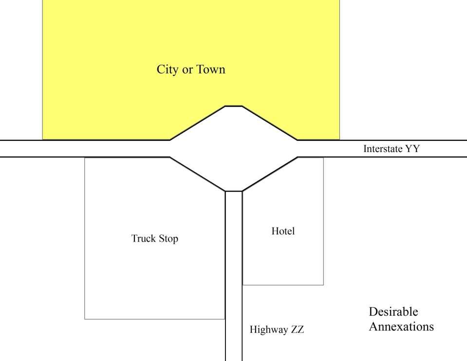
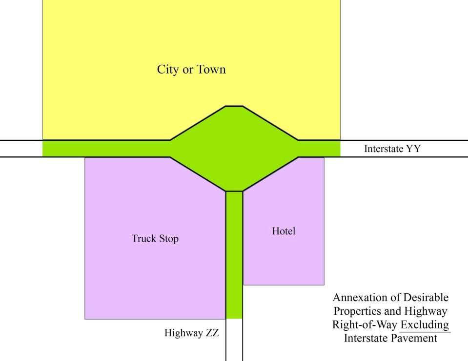
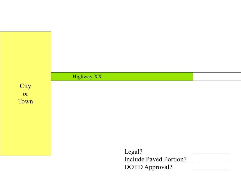
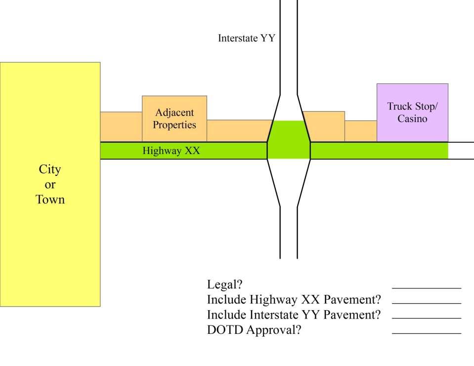
2 Overview Municipalities expand their boundaries through annexation of adjacent properties. Annexations must be contiguous; existing municipal area must connect with area to be added. Satellite annexations are prohibited. Highway right-of-way can be used to connect an existing municipal area with area to be added. Such use of highway right-of-way is addressed in R.S. 33:180. Must get Letter of No Objection from DOTD to annex state highway right-of-way.
3 RS 33: Ordinance to annex territory owned by a public body A. The governing body of any municipality other than the city of New Orleans may, by ordinance, enlarge the boundaries of the municipality to include territory within which all of the land is owned by a state agency, political subdivision, or public body, but only upon petition of the governing body of the agency, political subdivision, or public body owning the land which is to be so included. Except as otherwise provided by this Section, the governing body of the municipality may, in its discretion, upon majority vote thereof, adopt such an ordinance without the necessity of compliance with any of the procedures of advertisement, petition by residents, public hearing, or other procedures set forth in this Subpart. B. No municipality may annex the paved portion of a public road without including in such annexation all property adjacent to at least one side of the road, the paved portion of which is included in the annexation. At the discretion of the Department of Transportation and Development, the paved portion of an interstate highway right-of-way may be excluded from the annexation without the annexation being considered non-contiguous. C. A municipality may annex a portion of the right-of-way of a public road as a corridor connecting other property which is not contiguous to the municipality but which is to be annexed without including the property adjacent to the corridor. Any annexation pursuant to this Subsection shall be in accordance with the following: (1) The municipality shall, by certified mail, notify the state agency or political subdivision which owns the road proposed to be annexed at least thirty days prior to the introduction of the ordinance proposing such annexation. (2) The petition or written consent of the state agency or political subdivision must be received by the municipality prior to the adoption of the ordinance. Added by Acts 1964, No. 289, 1; Acts 1997, No. 1304, 1; Acts 2012, No. 594, 1, eff. June 7, 2012; Acts 2012, No. 594, 1.
4
5
6 Right-of-Way versus Pavement While highway right-of-way may be annexed to provide connectivity to a satellite property, the pavement cannot be annexed unless all property on at least one side of the road is included in the annexation. Without annexation of the pavement, traffic law enforcement remains with State Police and the local sheriff s office.
7
8
9 Interstate Right-of-Way Act 594 (HB 788) of 2012 Regular Session amended R.S. 33:180(B) At the discretion, of the DOTD, the paved portion of an interstate highway right-of-way may be excluded from the annexation without the annexation being considered non-contiguous. Allows municipalities to annex properties on the other side of the Interstate without annexing the Interstate pavement.
10
11
12 DOTD Philosophy We want to help Louisiana cities and towns develop. At the same time, we must guard against abuses. Some municipalities want to annex highway right-ofway, including the pavement, as a means of generating revenue through traffic law enforcement. Act 594 of the 2012 Regular Session allows us to help cities and towns while limiting the potential for abuse. We must be fair to all, apply RS 33:180 consistently, and do what s right.
13 Examples
14
15
16
17 Example Letter of No Objection

18 Right-Sizing the State Highway System
19 Who What When Where Why How Questions to Answer
20 Philosophy (Why) The more government we can keep at the local levels, in local hands, the better off we are and the more freedom we will have. President Reagan Annual Convention of the National Association of Counties, Baltimore, Maryland, July 13, 1982 This administration believes that responsibilities and resources should be restored to the governments which are closest to the people served. President Reagan Statement on Indian Policy, January 24, 1983

21 Philosophy (Why) state Taking power away from federal bureaucracies and giving it back to communities and individuals is something everyone should be able to be for The era of big government is over President Clinton State of the Union Address to Congress, January 25, 1995 President Clinton State of the Union Address to Congress, January 23, 1996
22 Philosophy (Why) Current model of strong state weak local government has been in place for 75 years or more. Current model has not produced good results. - Louisiana lags behind in many economic and social indicators. Many Louisiana citizens believe state government is too big.

23 Overview (Who & What) Opportunity exists to: Reduce the size of DOTD Empower local governments Correct inequities in the distribution of state highway miles among the parishes
24 Overview (Who & What) Concept of Right-Sizing the State Highway System involves transferring approximately 5000 miles of road, with the money, to local governments. State Highway System is too big; Right-Sizing has been called for in State Transportation Plan since DOTD needs to focus more on construction less on operations and maintenance. DOTD can help with capital projects for those local governments willing to accept greater O&M responsibilities.
25
26 LA Highway Network (Who & What) State Highway System 16,670 miles - Total Public Road System 61,000 miles - State Ownership in LA 27+ % - National Average 19 % Proposed State System 11,995 miles* - Net Decrease 5,035 miles** - State Ownership 19+ % * Includes 75 miles of new construction **Includes 284 miles of frontage roads

27 Role of State in Highway Network (Where) Ensure that Louisiana is well connected to the rest of the country and world Provide for the movement of people, goods, and services between and through urban areas. Travel within an urban area is a local responsibility Maintain a basic farm-to-market network in rural areas. These areas lack sufficient population, and therefore tax base, to maintain these facilities

28 Right- Sizing Principles (Where) State should not be maintaining neighborhood streets in urban or rural areas


29 Right- Sizing Principles (Where) State mileage inversely proportional to population As population increases, need for farm-to-market network decreases Former rural state roads become urban and suburban streets

30 Right-Sizing Principles (Where) In urban areas, the State System should consist only of roads that serve a significant interurban function Intraurban travel needs are best served by local governments even if streets have high traffic volumes
31 Transfer Mileage (Where) State Highway System mileage following transfer = 11, New State construction (including TIMED) = Revised State Highway System mileage = 11, Proposed limit for State Highway System = 12, miles* Excludes frontage roads Maps showing transfer roads have been developed for each parish Roads being retained by State are shown in red Roads proposed for transfer are shown in green Transferred roads do not disappear, rather the ownership changes

32
33 Compensation (When & How) Participation in the program is voluntary, it s straight business, and is available now. Roads will be repaired prior to transfer under the DOTD Road Transfer Program. Local governments will be credited for 40 years of routine and capital maintenance which can be applied to any highway capital project(s). Local governments interested in participating need to contact their DOTD District Administrator.

34 Benefits to Local Governments Immediate capital assistance with only minor near-term O&M cost increases Greater authority in transportation decision-making including prioritization and fund allocation Authority to regulate traffic and development over larger portion of network Ability to implement comprehensive plans with less interference/ less dependency on the State.

35 Benefits to State Government Seizing the opportunity will allow DOTD to focus on the system most important to the economy Freight movement Tourism Business travel
36 Realities and Opportunities Because of budgetary pressures, much of government is devolving to the local level. Those who want good infrastructure and amenities, and are willing to pay for it, can have it. The Road Transfer Program offers an opportunity for immediate capital assistance to jump start the repair and enhancement of infrastructure.
37 Interstate Frontage Roads Overview and Policy Louisiana Department of Transportation and Development
38 Interstate Highway System Overview Interstate Highway System is a national network of just under 43,000 miles of freeways. Construction began in the late 1950s and was largely completed in the 1990s. The Interstate Highway System is unsurpassed in highway mobility and safety. The Interstate Highway System is an engineering marvel truly the 8th wonder of the world
39 Purpose of the IHS The Interstate Highway System was constructed for national defense and interstate commerce. System planners recommended routing around urban areas; local leaders demanded that it pass through the heart of urban areas. Unfortunately, the Interstate has become Main Street in many communities serving as the main local traffic artery.
40 Desire to Access the IHS Since IHS construction began in the late 1950 s, attempts to access the system have been frequent and a source of conflict between State DOTs/FHWA and individuals/local governments. Transferring traffic from the local street network to the Interstate is often viewed as the solution to local congestion problems. Connecting streets and driveways to the IHS is frequently perceived as a path to individual and/or community economic gain.
41 Stewardship of the IHS Stewardship of the State Highway System, including the IHS, has been entrusted to DOTD. We take this responsibility very seriously and carefully consider a full range of possible impacts and possible futures when making policy decisions. Even so, for Interstate highways, the FHWA still exercises considerable oversight, particularly regarding adding or modifying access and regarding encroachments into the right-of-way.
42 Basic Interstate Section
43 Basic Interstate Section
44 Types of Frontage Roads Two-Way Two-Way
45 Types of Frontage Roads Backage (two-way) Backage (two-way)
46 Types of Frontage Roads Traditional One-Way Traditional One-Way
47 Types of Frontage Roads Traditional Traditional One-Way One-Way Detail Detail I
48 Types of Frontage Roads Two-Way with Slip Ramps I
49 Types of Frontage Roads X-Pattern One-Way X-Pattern One-Way
50 Types of Frontage Roads Hybrid One-Way Hybrid One-Way
51 DOTD Frontage Road Philosophy DOTD does not favor frontage roads. DOTD constructs frontage roads only when establishing new Interstate-type highways and only when such construction is less expensive than purchasing property that would otherwise be landlocked. Frontage roads result in greater concentrations of traffic in the Interstate corridor which in many cases is already congested.
52 DOTD Frontage Road Philosophy Frontage roads can cause operational and safety problems, even for the mainline of the Interstate. Frontage roads lead to land-use decisions and urban form not in keeping with current best planning practices. Frontage roads serve property on only one side. Backage roads are preferable.
53 DOTD Frontage Road Policy Local governments may construct frontage roads: For Two-Way or Backage types, no approval or permits from DOTD or FHWA are required except at connections to state highways. Two-Way Backage (two-way) For other types, DOTD/FHWA approval and permits are required.
54 However: DOTD Frontage Road Policy Frontage roads must be constructed on new right-ofway. Interstate right-of-way was acquired, through expropriation in many cases, to ensure adequate room for future expansion and to ensure adequate separation between the facility and adjacent land uses. Interstate right-of-way was not acquired for the purpose of frontage road construction.
55 Traditional One-Way DOTD must own frontage road between ramp connection and crossroad. No access connections allowed between ramp connection and crossroad. IMR and tripartite agreement required.
56 Two-Way with Slip Ramps Only appropriate in rural areas (1) where traffic volumes on ramps, frontage roads, and crossroads are very light; (2) where sight distance is not restricted; and (3) where access to adjacent rural land was denied during construction of the Interstate and is now absolutely necessary. DOTD must own frontage road between ramp connection and crossroad. IMR and tripartite agreement required.
57 X-Pattern One-Way DOTD will not allow this frontage road type. Continuity of control-of-access between Interstate mainline and state highway crossroad is not preserved. Autos/trucks traveling between Interstate and other state arterial highways should not be subject to travel on lower classification collector roads to make the connection.
58 Hybrid One-Way Frontage roads must connect one crossroad with another. X-Pattern One-Way allowed only for connections with local crossroads with control-of-access in vicinity of ramp connections. Connections to state highways must be Traditional One-Way with control-of-access preserved between mainline and crossroad. IMR and tripartite agreement required.
Metropolitan Planning Commission. DATE: April 5, 2016
 TO: FROM: Metropolitan Planning Commission MPC Staff DATE: April 5, 2016 SUBJECT: Petition of Nine Line Inc. Robert McCorkle, Agent PIN: 2-1034-01-002 380.5 Acres Aldermanic District: 5 (Shabazz) County
To achieve growth, property development, redevelopment and an improved tax base in the cities and boroughs in the Lehigh Valley.
 Most growth in property valuation is in townships. Between 1991 and 2004, the assessed valuation of the townships in the Lehigh Valley increased by more than $2.8 billion, an increase of 41%. At the same
SECTION 7000 LAND DEVELOPMENT REQUIREMENTS
 SECTION 7000 LAND DEVELOPMENT REQUIREMENTS 7000 LAND DEVELOPMENT REQUIREMENTS... 1 7001 LEGISLATIVE AUTHORITY... 1 7001.1 LAND DEVELOPMENT... 1 7001.1.1 Title 40, Idaho Code... 1 7001.1.2 Idaho Code 40-1415
MONTGOMERY COUNTY PLANNING DEPARTMENT THE MARYLAND-NATIONAL CAPITAL PARK AND PLANNING COMMISSION
 MONTGOMERY COUNTY PLANNING DEPARTMENT THE MARYLAND-NATIONAL CAPITAL PARK AND PLANNING COMMISSION MCPB Item No. 9 Date: 06-21-12 Proposed Zoning Text Amendment Revising the Requirements for Permitting Accessory
CITY OF COLORADO SPRINGS 2006 ANNEXATION PLAN CHAPTER 4 ENCLAVES
 CITY OF COLORADO SPRINGS 2006 ANNEXATION PLAN CHAPTER 4 ENCLAVES As the City has expanded, enclaves, remnants of land that are surrounded by the City, have remained within the jurisdiction of El Paso County.
MIDWAY CITY Municipal Code
 MIDWAY CITY Municipal Code TITLE 9 ANNEXATION CHAPTER 9.01 PURPOSE CHAPTER 9.02 GENERAL REQUIREMENTS CHAPTER 9.03 PROPERTY OWNER INITIATION OF ANNEXATION CHAPTER 9.04 PROCEDURES FOR CONSIDERATION OF PETITION
Comment: the Plan endeavors to conserve resources that can nurture additional development. What kind of resources, environmental, capital, or etc.?
 Memorandum TO: Peggy Fiandaca and Curt Dunham, Partners for Strategic Action Inc. FROM: Jessica Sarkissian, CMX DATE: September 4, 2008 SUBJECT: Proposed 2008 Draft Comprehensive Plan Comments This memo
17.0 NONCONFORMITIES CHAPTER 17: NONCONFORMITIES Purpose and Applicability
 17.0 NONCONFORMITIES 17.1 Purpose and Applicability The purpose of this section is to regulate and limit the continued existence of uses and structures established prior to the effective date of this Ordinance
UNOFFICIAL COPY OF HOUSE BILL 1272 A BILL ENTITLED
 UNOFFICIAL COPY OF HOUSE BILL 1272 M4 6lr0525 By: Delegates Smigiel, Kelley, Rosenberg, and Sossi Introduced and read first time: February 10, 2006 Assigned to: Environmental Matters 1 AN ACT concerning
APA National Conference Monday, May 8 10:30 a.m. -11:45 a.m. Room: Hall 1E09 (JCC)
") APA National Conference Monday, May 8 10:30 a.m. -11:45 a.m. Room: Hall 1E09 (JCC) Dr. Linda Tomaselli, GIS Research and Development Consultants (GISRDC) Ms. Vasudha Pinnamaraju, Executive Director, McLean
APA National Conference Monday, May 8 10:30 a.m. -11:45 a.m. Room: Hall 1E09 (JCC) Dr. Linda Tomaselli, GIS Research and Development Consultants (GISRDC) Ms. Vasudha Pinnamaraju, Executive Director, McLean
City of Edwardsville, Kansas Special Benefit District Policy
 City of Edwardsville, Kansas Special Benefit District Policy Date Adopted: September 12, 2011 Section 1. Objective The objective is to establish a policy to finance public streets, sanitary sewers, water
Worksession Agenda. 3. Request to Discuss the Initial Zoning to be Applied to The Carolina Golf Course Property; Petitioner, Town of Southern Pines
 Town of Southern Pines Monday November 27, 2017, 3:00 PM, C. Michael Haney Community Room, Southern Pines Police Department 450 West Pennsylvania Avenue Worksession Agenda 1. Request to Discuss a Potential
Midway City Council 2 October 2018 Regular Meeting. Issuance of General Obligation Bonds / Public Meeting
 Midway City Council 2 October 2018 Regular Meeting Issuance of General Obligation Bonds / Public Meeting Memo Date: 29 September 2018 To: Mayor, City Council and Staff Cc: File From: Brad Wilson, City
Attachment 4 ANALYSIS I. Current Special Exception Use Standards for Accessory Apartments (Also See Attachment 2 Table for Quick Comparison)
") The Planning Board conducted the first of its public hearings/worksessions on the proposed accessory apartment provisions on May 3, 2012. At that time, the Board determined that additional input from stakeholders
The Planning Board conducted the first of its public hearings/worksessions on the proposed accessory apartment provisions on May 3, 2012. At that time, the Board determined that additional input from stakeholders
Indicates Council-recommended changes Introduced by: Mr. Tackett Date of introduction: June 14, 2016 SUBSTITUTE NO. 1 TO ORDINANCE NO.
 Indicates Council-recommended changes Introduced by: Mr. Tackett Date of introduction: June 14, 2016 SUBSTITUTE NO. 1 TO ORDINANCE NO. 16-067 TO AMEND NEW CASTLE COUNTY CODE CHAPTER 40 (ALSO KNOWN AS THE
SECTION 874 SITE PLAN REVIEW
 SECTION 874 SITE PLAN REVIEW When a site plan review is required by this Division or Chapters 17.72 or 17.30 of the Fresno County Ordinance Code, the following procedure shall apply: A. SITE PLAN The purpose
City of Peachtree City. Annexation Review Process
 City of Peachtree City Annexation Review Process Page 1 Annexation Review Process Step One: Initial annexation information The following information is to be completed by the property owner and/ or their
Whither the Wilderness County?
 Whither the Wilderness County Lane Kendig Kendig Keast Collaborative Scott Clark Director, Kootenai County Community Development Wilderness City Wilderness City is an oxymoron. Urban City cannot be a wilderness.
Section 1: US 19 Overlay District
 Section 1: US 19 Overlay District Section 1.1 Intent and Purpose The purpose of the US Highway 19 Overlay District is to manage access to land development along US Highway 19 in a manner that preserves
Draft Model Access Management Overlay Ordinance
 Draft Model Access Management Overlay Ordinance This model was developed using the City of Hutchinson and the Trunk Highway 7 corridor. The basic provisions of this model may be adopted by any jurisdiction
L. LAND USE. Page L-1
 L. LAND USE 1. Purpose This section discusses current and likely future land use patterns in Orland. An understanding of land use trends is very important in determining Orland's ability to absorb future
DESIGN PUBLIC HEARING MAY 18, 2017 GROVELAND TOWN HALL GROVELAND, MASSACHUSETTS 7:00PM FOR THE PROPOSED
 DESIGN PUBLIC HEARING MAY 18, 2017 AT GROVELAND TOWN HALL GROVELAND, MASSACHUSETTS 7:00PM FOR THE PROPOSED GROVELAND COMMUNITY TRAIL PROJECT Roadway Project Management Section IN THE TOWN OF GROVELAND,
Master Plan Review SILVER SPRING CBD. Approved and Adopted February Updated January 2013
 Master Plan Review SILVER SPRING CBD Approved and Adopted February 2000 BACKGROUND ZONING CODE REWRITE In 2007, the Montgomery County Council directed the Planning Department to undertake a comprehensive
MPC STAFF REPORT REZONING MAP AMENDMENT ALDERMANIC DISTRICT 1 COUNTY COMMISSION DISTRICT 5 April 3, 2013 MPC FILE NUMBER.
 MPC STAFF REPORT REZONING MAP AMENDMENT ALDERMANIC DISTRICT 1 COUNTY COMMISSION DISTRICT 5 April 3, 2013 MPC FILE NUMBER. 13-000929-ZA REZONING SUMMARY Report Status Initial Report Petitioner/Property
TOWN OF ELIOT PLANNING BOARD SUBDIVISION APPLICATION
 TOWN OF ELIOT PLANNING BOARD SUBDIVISION APPLICATION This application shall conform in all respects to the Land Subdivision Standards of Chapter 41 of the Planning Board of the Town of Eliot code of ordinances.
ORDINANCE NO AN ORDINANCE AMENDING THE CODE OF ORDINANCES OF THE CITY OF PORT ARANSAS, TEXAS, BY ADOPTING A NEW CHAPTER
 ORDINANCE NO. 2008-09 AN ORDINANCE AMENDING THE CODE OF ORDINANCES OF THE CITY OF PORT ARANSAS, TEXAS, BY ADOPTING A NEW CHAPTER TWENTY-SIX CONCERNING IMPACT FEES FOR ROADWAY FACILITIES; INCORPORATING
AAAA. Planning and Zoning Staff Report Lake Shore Land Holdings, LLC CU-PH Analysis
 AAAA Planning and Zoning Staff Report Lake Shore Land Holdings, LLC CU-PH2016-28 Hearing Date: April 21, 2016 Development Services Department Applicant: BRS Architects/Cindy Huebert Staff: Kyle McCormick,
RC ; Reclassification The Garrison at Stafford Proffer Amendment (formerly Stafford Village Center)
") Board of Supervisors Robert Bob Thomas, Jr., Chairman Laura A. Sellers, Vice Chairman Meg Bohmke Jack R. Cavalier Wendy E. Maurer Paul V. Milde, III Gary F. Snellings Anthony J. Romanello, ICMA CM County
Board of Supervisors Robert Bob Thomas, Jr., Chairman Laura A. Sellers, Vice Chairman Meg Bohmke Jack R. Cavalier Wendy E. Maurer Paul V. Milde, III Gary F. Snellings Anthony J. Romanello, ICMA CM County
ANNEXATION. The Handbook for Georgia Mayors and Councilmembers 1
 ANNEXATION Growing and prosperous Georgia cities create a growing and prosperous Georgia. Although cities comprise only 6.8% of Georgia s land area, approximately 40% of the state s population lives in
M-43 CORRIDOR OVERLAY ZONE
 ARTICLE 26.00 M-43 CORRIDOR OVERLAY ZONE Section 26.01 Findings A primary function of the M-43 state highway is to move traffic through the Township and to points beyond. As the primary east-west arterial
People, Property and Power Lines. Frequently asked questions about power lines on or near your property
 People, Property and Power Lines Frequently asked questions about power lines on or near your property Great River Energy is a not-for-profit wholesale electric power cooperative which provides electricity
NC General Statutes - Chapter 136 Article 6D 1
 Article 6D. Controlled-Access Facilities. 136-89.48. Declaration of policy. The General Assembly hereby finds, determines, and declares that this Article is necessary for the immediate preservation of
Part 5 - Accommodating Utility Facilities Within Public Freeway Rights-of-Way and Public Railroad Rights-of-Way
 290-RICR-20-00-5 TITLE 290 - DEPARTMENT OF TRANSPORTATION CHAPTER 20 - GOVERNMENT AND UTILITIES SUBCHAPTER 00 - N/A Part 5 - Accommodating Utility Facilities Within Public Freeway Rights-of-Way and Public
THE CORPORATION OF THE TOWNSHIP OF NORTH FRONTENAC BY-LAW #123-13
 THE CORPORATION OF THE TOWNSHIP OF NORTH FRONTENAC BY-LAW #123-13 Being a By-law to Adopt an Assumption of Unmaintained Municipal Roads and Private Lanes Policy and Minimum Road Construction Standards
Land Use. Land Use Categories. Chart 5.1. Nepeuskun Existing Land Use Inventory. Overview
 Land Use State Comprehensive Planning Requirements for this Chapter A compilation of objectives, policies, goals, maps and programs to guide the future development and redevelopment of public and private
Evaluating and Processing Road and Utility Easement Proposals on Corps Lands and Flowage Easements
 Evaluating and Processing Road and Utility Easement Proposals on Corps Lands and Flowage Easements Don Wiese Natural Resources Manager Fort Worth District September 13, 2017 US Army Corps of Engineers
Public Information Meeting: Mattapany Rural Legacy Area - Proposed Expansion
 Public Information Meeting: Mattapany Rural Legacy Area - Proposed Expansion What is the Rural Legacy Program? Maryland s Rural Legacy Program provides funding to: preserve large, contiguous tracts of
1. Overview : 2. Eligible Housing Projects:
 Oneida County Industrial Development Agency Uniform Tax Exemption and Agency Benefits Policy Market Rate Rental Housing Development Initiatives (Effective March 1, 15 and revised on April, 18) 1. Overview
UNDERSTANDING THE TAX BASE CONSEQUENCES OF LOCAL ECONOMIC DEVELOPMENT PROGRAMS
 UNDERSTANDING THE TAX BASE CONSEQUENCES OF LOCAL ECONOMIC DEVELOPMENT PROGRAMS Richard K. Gsottschneider, CRE President RKG Associates, Inc. 277 Mast Rd. Durham, NH 03824 603-868-5513 It is generally accepted
Farmland and Open Space Preservation Purchase of Development Rights Program Frequently Asked Questions
 Farmland and Open Space Preservation Purchase of Development Rights Program Frequently Asked Questions Why should a community consider farmland preservation programs? Farmland preservation is important
NATIONAL ASSOCIATION OF REALTORS. National Center for Real Estate Research
 NATIONAL ASSOCIATION OF REALTORS National Center for Real Estate Research COMMUNITY ACCEPTANCE OF AFFORDABLE HOUSING C. Theodore Koebel Robert E. Lang Karen A. Danielsen Center for Housing Research and
2 April 9, 2014 Public Hearing
 2 April 9, 2014 Public Hearing APPLICANT (Street Closure): EBENEZER BAPTIST CHURCH APPLICANT & PROPERTY OWNER (Use Permit Modification): EBENEZER BAPTIST CHURCH STAFF PLANNER: Kevin Kemp REQUESTS: A. Street
Chapter Four Growth in the Next 20 years
 Chapter Four Growth in the Next 20 years Although the city of Fargo has pushed to the limits planned for in the original growth plan, the city still has substantial amounts of land available for growth.
DRAFT -- PROPOSED EXPANSION AND REVISIONS TO DIVISION 24. SPECIAL DISTRICT--COLLEGE AND UNIVERSITY NEIGHBORHOODS DISTRICT
 DRAFT -- PROPOSED EXPANSION AND REVISIONS TO DIVISION 24. SPECIAL DISTRICT--COLLEGE AND UNIVERSITY NEIGHBORHOODS DISTRICT Sec. 28-831. Purpose. The college and university neighborhoods district purposes
ARTICLE V: PUBLIC FACILITIES AND SERVICES V PUBLIC FACILITY AND SERVICE REQUIREMENTS
 ARTICLE V: PUBLIC FACILITIES AND SERVICES V 1 501 PUBLIC FACILITY AND SERVICE REQUIREMENTS 501 1 Intent and Purpose The intent of this Section is to identify those public facilities and services that are
City of Valdosta Land Development Regulations
 Title 2 Land Use and Zoning Chapter 202 Section 202-1 General Provisions Purpose Title 2 is intended to implement the purposes set forth in Section 102-2, and further is enacted for the purposes of promoting
Economic Empowerment District (draft) Enhanced Factsheet
 Enhanced Factsheet") Economic Empowerment District (draft) Enhanced Factsheet Contents PURPOSE... 1 APPLICABILIT... 1 Classification... 1 EED Designation Criteria... 1 ZONING DESIGNATION & DEVELOPMENT REVIEW PROCESS... 2 Zoning
Economic Empowerment District (draft) Enhanced Factsheet Contents PURPOSE... 1 APPLICABILIT... 1 Classification... 1 EED Designation Criteria... 1 ZONING DESIGNATION & DEVELOPMENT REVIEW PROCESS... 2 Zoning
Senate Eminent Domain Bill SF 2750 As passed by the Senate. House Eminent Domain Bill HF 2846/SF 2750* As passed by the House.
 Scope Preemption. Provides that Minn. Stat. Chapter 117 preempts all other laws, including special laws, home rule charters, and other statutes, that provide eminent domain powers. Public service corporation
EMINENT DOMAIN Educational Series
 EMINENT DOMAIN 2017 Educational Series EMINENT DOMAIN OVERVIEW For decades, the Texas Department of Transportation (TxDOT) has been acquiring real property to establish a modern state highway system. The
EXPRESS LANES NORTHERN EXTENSION TECHNICAL REPORT SEPTEMBER 2016
 I N T E R S TAT E 3 9 5 EXPRESS LANES NORTHERN EXTENSION R I G H T O F W AY TECHNICAL REPORT SEPTEMBER 2016 INTERSTATE 395 EXPRESS LANES NORTHERN EXTENSION Right of Way Technical Report City of Alexandria,
ESTES VALLEY STORMWATER MANAGEMENT PROGRAM
 ESTES VALLEY STORMWATER MANAGEMENT PROGRAM Phase I. Stormwater Master Plan Phase II. Stormwater Utility Feasibility Study Board of Realtors Meeting May 3, 2018 Stormwater Master Plan Summary Stormwater
LINCOLN COUNTY COUNTY ROAD STANDARDS AND ROAD POLICY
 LINCOLN COUNTY COUNTY ROAD STANDARDS AND ROAD POLICY 1. Historical Overview Relating to County Roads 2. Current Overview 3. County Road Districts 4. Designation of County Roads by Classification a. Primary
Questions Answers. Trust for Architectural Easements
 & Questions Answers Trust for Architectural Easements & Questions Trust for Architectural Easements Answers The Federal Historic Preservation Tax Incentive Program, a program created by Congress, allows
Article 18. Sign Regulations
 Article 18. Sign Regulations Section 18.01 Purpose and Intent Section 18.02 Use Regulations Section 18.03 Classification of Signs Section 18.04 Structural Types Section 18.05 General Standards Section
The role of, government, urban planners and markets
 Module 1: Introduction and the Context The role of, government, urban planners and markets Alain Bertaud Urbanist Summary Government and real estate markets Role of government and role of urban planners
Open Space Model Ordinance
 Open Space Model Ordinance Section I. Background Open space development has numerous environmental and community benefits, including: 1) Reduces the impervious cover in a development. Impervious cover
R/W PREQUALIFICATION ODOT, 3/14/2018
 R/W PREQUALIFICATION ODOT, 3/14/2018 BRETT SHEARER, C.O. REAL ESTATE PROPOSED RIGHT OF WAY DESIGN 172 PROPOSED RIGHT OF WAY DESIGN PROPOSED RIGHT OF WAY DESIGN Section 3200 Types of Title 173 PROPOSED
Street Improvement Plan Residential/Local Reconstruction Funding Options Part 2 Council Presentation July 21, 2015
 Street Improvement Plan Residential/Local Reconstruction Funding Options Part 2 Council Presentation July 21, 2015 1 Overview of Update Paving Assessments Public Improvement Districts Industrial District
ORDINANCE NO AN ORDINANCE ESTABLISHING A UNIFORM SYSTEM FOR STREET ADDRESSING IN EMERY COUNTY
 ORDINANCE NO. 21505 AN ORDINANCE ESTABLISHING A UNIFORM SYSTEM FOR STREET ADDRESSING IN EMERY COUNTY The County Commission of the County of Emery, State of Utah, being the Legislative Body of said county,
2004 ANNUAL TOWN MEETING AMENDMENT TO ZONING BYLAW HOME OCCUPATIONS
 2004 ANNUAL TOWN MEETING ARTICLE 8 AMENDMENT TO ZONING BYLAW HOME OCCUPATIONS RECOMMENDATION The Planning Board recommends that Article 8 be APPROVED. BACKGROUND (Note: This report includes information
Follow the Numbers: Why We Oppose the Inclusion of the Illiana Expressway in GO TO 2040 August 30, 2013
 Follow the Numbers: Why We Oppose the Inclusion of the Illiana Expressway in GO TO 2040 August 30, 2013 The Illinois Dept. of Transportation (IDOT) has requested that the Chicago Metropolitan Agency for
Town of Scipio Comprehensive Plan Public Survey 2008
 Town of Scipio Comprehensive Plan Public Survey 2008 Please answer all of the questions. If you do not have an opinion, please leave the space blank. Your input will help us create a plan that is representative
Secondary Street Acceptance Requirements Virginia Administrative Code
 Secondary Street Acceptance Requirements Virginia Administrative Code 24VAC30-92-10. Definitions. The following words and terms when used in these regulations shall have the following meanings unless the
CZMP Workshop Preserving Your Community & The Environment From Development Impacts
 CZMP Workshop Preserving Your Community & The Environment From Development Impacts Sponsored By Community & Environmental Defense Services 410-654-3021 www.ceds.org/bcmd Help@ceds.org Greater Baltimore
General Manager of Planning and Development Services in consultation with the Director of Legal Services
 POLICY REPORT DEVELOPMENT AND BUILDING Report Date: February 5, 2015 Contact: Anita Molaro Contact No.: 604.871.6479 RTS No.: 10821 VanRIMS No.: 08-2000-20 Meeting Date: February 17, 2015 TO: FROM: SUBJECT:
Introduction to INRMP Implementation Options
 El Dorado County Integrated Natural Resources Management Plan Introduction to INRMP Implementation Options 1 Our approach to the options evaluation is based on the INRMP components as they are currently
National Technical University of Athens School of Rural and Surveying Engineering
 National Technical University of Athens School of Rural and Surveying Engineering INFORMAL SETTLEMENTS REAL ESTATE MARKET NEED FOR GOOD LAND ADMINISTRATION AND PLANNING FIG COM3, UNECE CHLM & WPLA JOINT
Actual & Projected Population
 Annexation Policy and the Comprehensive Plan Presentation November 9, 2012 1 Annexation Policy Document Overview: Background, history, and strategies Policy: Policy Statements t t to guide and provide
6208 Jeanne D Arc Boulevard North. Planning Rationale. Site Plan Control
 Site Plan Control Prepared By: NOVATECH Suite 200, 240 Michael Cowpland Drive Ottawa, Ontario K2M 1P6 November / 24 / 2015 Novatech File: 115100 Ref: R-2015-179 November 24, 2015 City of Ottawa 110 Laurier
CHAPTER 352 COUNTY LAND PRESERVATION AND USE COMMISSIONS
 CHAPTER 352 COUNTY LAND PRESERVATION AND USE COMMISSIONS Referred to in 6B.3, 15E.111, 159.6, 173.3, 455B.275 Chapter does not invalidate ordinances existing on July 1, 1982, or require adoption of zoning
Implementation. Approved Master Plan and SMA for Henson Creek-South Potomac 103
 Implementation Approved Master Plan and SMA for Henson Creek-South Potomac 103 104 Approved Master Plan and SMA for Henson Creek-South Potomac Sectional Map Amendment The land use recommendations in the
SPECIFIC RESPONSES TO AREA COMMISSION OPPOSITION :
 SPECIFIC RESPONSES TO AREA COMMISSION OPPOSITION 3-14-19: Area Commission reasons for opposition in black APPLICANT S RESPONSE IN RED. The comprehensive planning and design of stream restoration efforts
SINGLE FAMILY LOT SIZE POLICY MANUAL
 CITY OF RICHMOND SINGLE FAMILY LOT SIZE POLICY MANUAL Table of Contents How to Use the Manual 1 How to Read the Policy 2 Single Family Lot Size Policy (702) & Rezoning Process 3 Single Family Lot Size
Developing Land Policy in a Post-Conflict Environment: The Case of Southern Sudan
 Developing Land Policy in a Post-Conflict Environment: The Case of Southern Sudan Steven Lawry and Biong Deng World Bank Conference on Land and Poverty Washington, D.C April 19, 2011 Land so pervasively
PLANNING COMMISSION REPORT Regular Agenda Public Hearing Item
 PC Staff Report 11/12/12 Item No. 2B- 1 PLANNING COMMISSION REPORT Regular Agenda Public Hearing Item ITEM NO. 2B: A TO GPI; 110 ACRES; E OF K-10 & N OF W 6 TH ST (MKM) : Consider a request to rezone approximately
Subpart A - GENERAL ORDINANCES Chapter 66 - TAXATION ARTICLE V. - ECONOMIC DEVELOPMENT AD VALOREM TAX EXEMPTION
 Sec. 66-171. - Title. Sec. 66-172. - Enactment authority. Sec. 66-173. - Findings of fact. Sec. 66-174. - Definitions. Sec. 66-175. - Establishment of economic development ad valorem tax exemption. Sec.
DEPARTMENT OF PLANNING JEFFERSON PARISH, LOUISIANA
 DEPARTMENT OF PLANNING JEFFERSON PARISH, LOUISIANA SUBDIVISION REPORT DOCKET NO: ES-89-15-PF SUMMARY NO: COUNCIL DISTRICT 2 Paul D. Johnston COUNCIL AT LARGE: A Chris Roberts B Elton M. Lagasse ADVERTISING
Planning and Zoning Staff Report JT Ventures, LLC Staging Area, CU-PH
 Planning and Zoning Staff Report JT Ventures, LLC Staging Area, CU-PH2016-60 Hearing Date: December 15, 2016 Development Services Department Applicant: JT Ventures, LLC Jason Stewart and Tony Brown Staff:
a. provide for the continuation of collector streets and thoroughfare streets between adjacent subdivisions;
 Section 7.07. Intent The requirements of this Section are intended to provide for the orderly growth of the Town of Holly Springs and its extra-territorial jurisdiction by establishing guidelines for:
Mount Airy Planning Commission March 26, Staff Report
 Mount Airy Planning Commission March 26, 2018 Staff Report Special Exception Request Mixed Use Development in CC District Recommendation to Board of Appeals CASE MA-A-18-01 Applicant: Location: Zoning:
RESEARCH BRIEF. Oct. 31, 2012 Volume 2, Issue 3
 RESEARCH BRIEF Oct. 31, 2012 Volume 2, Issue 3 PDR programs affect landowners conversion decision in Maryland PDR programs pay farmers to give up their right to convert their farmland to residential and
WHEREAS, the City of Kenosha, Wisconsin is a Wisconsin municipality with offices at nd Street, Kenosha, Wisconsin 53140; and
 2017 CITY OF KENOSHA/VILLAGE OF SOMERS/TOWN OF SOMERS/TOWN OF PARIS/COUNTY OF KENOSHA/KENOSHA WATER UTILITY/VILLAGE OF SOMERS WATER UTILITY/VILLAGE OF SOMERS SEWERAGE DISTRICT/COUNTY HIGHWAY COMMISSIONER
STAFF REPORT. Permit Number: Lee. Kitsap County Board of Commissioners; Kitsap County Planning Commission
 STAFF REPORT Permit Number: 15 00689 Lee DATE: March 2, 2016 TO: FROM: Kitsap County Board of Commissioners; Kitsap County Planning Commission Katrina Knutson, AICP, Senior Planner, DCD and Jeff Arango,
CHAPTER 3 PERMITS, PLANS AND ANNEXATION
 CHAPTER 3 PERMITS, PLANS AND ANNEXATION SECTION: 10-3-1: General Regulations 10-3-2: Building Permit 10-3-3: Plans 10-3-4: Certificate of Compliance and Occupancy 10-3-5: Conditional Use Permits 10-3-6:
Canton Roads 2017 Study Session
 Canton Roads 2017 Study Session August 29, 2017 Presented by: Bill Serchak, Canton Township Gorette Yung, MDOT Ron Agacinski, Wayne County Carmine Palombo, SEMCOG Road Funding Topics Who owns what? How
A REVIEW OF THE NIGERIAN LAND USE ACT OF 1978
 A REVIEW OF THE NIGERIAN LAND USE ACT OF 1978 1 Adamu, S.J. and 2 Kawuwa, A.S 1 Department of Geography, Gombe State University, Tudun Wada Gombe, Gombe State, Nigeria. 2 Architecture Programme, Abubakar
BOI / DRH Albertsons grocery market and fueling center & pad sites
 Paul Woods, President Rebecca W. Arnold, Vice President Sara M. Baker, Commissioner Jim D. Hansen, Commissioner Kent Goldthorpe, Commissioner March 28, 2017 To: Mark Palmer Albertsons Companies 250 E.
CITY OF MADISON, WISCONSIN
 CITY OF MADISON, WISCONSIN AN AMENDED SUBSTITUTE ORDINANCE Amending Section 28.04(25) to add a sunset provision, creating new Section 28.04(26) to set out a new inclusionary housing program, and renumbering
Local and Federal Funding for Mainland Beach Restoration Projects
 Local and Federal Funding for Mainland Beach Restoration Projects Presented by: Andrew Wycklendt (CB&I) Hawaii Shore and Beach Preservation Association 2014 Beach Restoration Workshop November 24, 2014
Worksession Agenda. 1. Swearing In of Paul Murphy as Councilmember
 Town of Southern Pines Monday November 26, 2018, 3:00 PM, C. Michael Haney Community Room, Southern Pines Police Department 450 West Pennsylvania Avenue Worksession Agenda 1. Swearing In of Paul Murphy
PERSPECTIVE ON POLITICS
 PERSPECTIVE ON POLITICS A Primer on How KAR Protects and Advances Property Rights Across Kansas 2018 Legislative Priorities We are the Kansas REALTOR Party: An energized movement of real estate professionals
SERVICE & IMPROVEMENT PLAN AND ASSESSMENT PLAN:
 DOWNTOWN MIDLAND MANAGEMENT DISTRICT SERVICE & IMPROVEMENT PLAN AND ASSESSMENT PLAN: 2010-2019 August 25, 2009 Table of Contents 1. Introduction...1 2. Background: The First Five Years...2 3. Service &
C HAPTER 15: N ONCONFORMITIES
 SECTION 15.1: PURPOSE AND APPLICABILITY The purpose of this Chapter is to regulate and limit the continued existence of uses and structures established prior to the effective date of this Code (or any
13 Sectional Map Amendment
 13 Sectional Map Amendment Introduction This chapter reviews land use and zoning policies and practices in Prince George s County and presents the proposed zoning in the sectional map amendment (SMA) to
CHAPTER IV IMPLEMENTATION
 CHAPTER IV IMPLEMENTATION Chapter Outline IV. Implementation Page A. Public Works Projects/Public Infrastructure IV-1 1. Facilities Master Plan Overview IV-1 2. Facilities Master Plan Service Standards
Jefferson County. Case RZ. Presenter: Alan Tiefenbach. Planning and Zoning Division
 Green Gables Official Development Plan Case 11-119319RZ Presenter: Alan Tiefenbach Proposal Rezone from Agricultural-Two (A-2) to Planned Development (PD) 225,000 square feet of commercial uses, including
MEMORANDUM. Tax map number(s) / total acreage: acres of parcel 20D-4-D1 & acres of parcel 20D-4-D / /- acres total
 / total acreage: acres of parcel 20D-4-D1 & acres of parcel 20D-4-D / /- acres total") MEMORANDUM To: From: Subject: Board of Supervisors Sandra M. Shackelford, Planner SMS Rezoning # PL-15-25 (Timberlake Road) Date: October 27, 2015 BACKGROUND: This request is to rezone 17.048 +/- acres
MEMORANDUM To: From: Subject: Board of Supervisors Sandra M. Shackelford, Planner SMS Rezoning # PL-15-25 (Timberlake Road) Date: October 27, 2015 BACKGROUND: This request is to rezone 17.048 +/- acres
Staff presented two options for the Commission to consider recommending to Town Council:
 Attendance: Chair Darrell Page; Commissioners: Ann Holland, Scott Burroughs, Steve Clark, Pam Barger, Pam Carter, Michael Aldridge (arrived at 7:39); Hilda Keeney, Planning and Zoning Clerk; Kassie Watts,
Kempermill Village Neighborhood Meeting. February 5, 2018
 Kempermill Village Neighborhood Meeting February 5, 2018 Overview of Tonight s Meeting Overview of Springfield Township 5 Year Infrastructure Plan Current Pavement Condition Cedarcreek, Centerbrook, Canfield
HAMILTON COUNTY SECONDARY ROAD DEPARTMENT DRIVEWAY AND ENTRANCE POLICY EFFECTIVE NOVEMBER 28, 2017
 Updated November 28, 2017 HAMILTON COUNTY SECONDARY ROAD DEPARTMENT DRIVEWAY AND ENTRANCE POLICY EFFECTIVE NOVEMBER 28, 2017 POLICY INTENT This policy is intended to govern all aspects of access from Hamilton