CZMP Workshop Preserving Your Community & The Environment From Development Impacts
|
|
|
- Clinton Stewart
- 6 years ago
- Views:
Transcription
1 CZMP Workshop Preserving Your Community & The Environment From Development Impacts Sponsored By Community & Environmental Defense Services Greater Baltimore Group of the Sierra Club maryland.sierraclub.org/baltimore/
2 Preservation Is THE Best Option PLEASE Do not wait until development is proposed.
3 This study showed once a site is proposed for development, the odds strongly favor that the project will be approved. Development plan approval is denied for only one out of 37 plans. The plans for two these denials were revised then approved with only a slight decrease in the number of lots. This study is available on the CEDS Baltimore County Webpage
4 To Preserve A Property Act NOW! Before Development Is Proposed When Your Power is GREATEST! So Don t t Delay; ; Start TODAY!
5 Preservation Options Forest Conservation Clustering Conservation Easement Limited Development Venture Purchase of Development Rights Acquisition Rezoning Options Can Be Used To Preserve Property in Total or in Part
6 Researching Preservation Options Start with the property nearest your home and work outwards. 1. Could the property be developed in ways harmful to you? 2. If yes,, continue. Otherwise go on to the next property. 3. Is the property already proposed for development? - If yes, then see Chapter 1 in How To Win Land Development Issues at - If no, then is the property already preserved? 4. If no, then research factors favoring preservation. 5. Meet with County planner re: previous attempts to develop the property, preservation options, and possible conditions to address your concerns. 6. Meet with the property owner to explore their interest in preservation-conditions. 7. Do research needed to put together a preservation or conditions deal the owner finds attractive yet fully resolves your concerns. 8. Consummate the deal in a way that is fully binding.
7 Could the Property Be Developed In Ways Harmful To Your Quality of Life Most common development impacts: Intrude upon the privacy of your home; Detract from the view you enjoy from your home; Increase runoff onto your property; Increase traffic on your street; Impair the rural character of your area; Harm aquatic resources, forests, wildlife; ; or Cause one of 18 other common impacts.
8 18 Other Common Development Impacts to Nearby Residents Compatibility Emergency Services Endangered Species Impact Environmental Impact Farming Conflicts Forest Conservation Historic Resources Lighting (Glare) Noise Open Space Loss Parking Inadequacy Pedestrian Safety Property Value Property Damage School Overcrowding Signage Stormwater & Flooding Stream Buffers Traffic Trails (Bike-Hike) Water & Sewer Well & Septic Systems Wetland Impacts Wildlife Impacts

9 INFILL EXAMPLE QUALITY OF LIFE IMPACTS Traffic Drainage Loss of Pleasing View


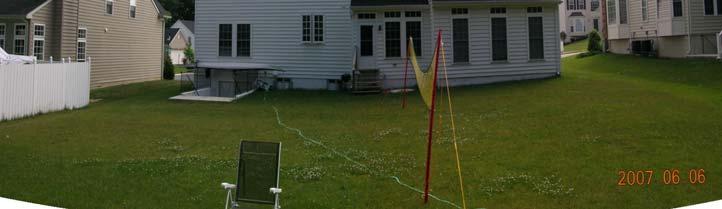
10 Example of Infill Impact Loss of Privacy & Viewshed Before Development After Development

11 If Zoned DR-3.5 Then Rezoning To DR-1 Would Reduce Impact
12 Solutions To Infill Impacts Preserve site; Use Forest Conservation to Preserve View; Visual buffer; Build one house, not two; Traffic calming measures; Alternate traffic access; and Stormwater management.
13 Rural Preservation Example Property

14 Determine Extent of Property Property Consists of 3 parcels totaling 110 acres Get Property Map and Parcels Numbers

15 Look Up Property Record To See If It Has Been Platted for Development? Ask CEDS & County planner too.
16 If development is proposed then see How To Win Land Development Issues Free 280-page Book

17 And see CEDS Webpage How To Win Land Development Issues in Baltimore County

18 What uses of Property does current zoning allow? 110 Acres Is Zoned RC-2 Agricultural 2 Lots Per Parcel Property Unless parcel was subdivided after Otherwise 0.02 Lots Per Acre Zoning Symbol (RC-2) 2-6 Lots on 110 Acres
19 Uses Allowed On RC-2 Yes, potentially incompatible uses are allowed.

20 Is The Property Already Preserved? Property No. Its not preserved but it does abut preserved land, which favors preservation.

21 Is the Property Uniquely Sensitive Environmentally? Threatened-Endangered Species Property Wetland of Special State Concern Yes. Its in a Sensitive Species Project Review Area (SSPRA).


22 Does The Property Have Historical Significance? Property Yes. There is a historic building on the property.
23 Other Factors Potentially Favoring Preservation Area dominated by working farms; Prime, productive farm soils; Poor well yield or unsuited for septics; Paucity of parks-recreation recreation in area; Road network nearing capacity; Schools over capacity; Etc.
24 North County Preservation ARC Database Zoning & Property Maps; Sensitive Environmental Features; Detailed Data On Specific Properties; Preserved Lands; Historic Structures & Districts; and Much More! For further detail contact: Irving Spitzberg northcountypreservation.org
25 Rural Example Preservation Options Forest Conservation (50% retention) Clustering (2-6 6 lots; 3-acres 3 each; 18 acres; 96%) Conservation Easement (reduced taxes) Limited Development Venture (1 or 2 lots) Purchase of Development Rights ($4,000-8,000/acre vs. $14,000; keep property) Acquisition (Very rare; requires tremendous public support) Acquisition Rezoning (Incentive-Disincentive)
26 REZONING A Powerful Tool For Citizens Rezoning As Incentive: YOU control what gets built & where; and The owner may get more LOTS. Rezoning As Disincentive: Use only in extreme cases; Offer more lots; Threaten reduced development potential; Unless owner agrees to responsible uses.
27 Example of Rezoning As Incentive 200 acre farm zoned RC-2; Abuts RC-5 5 land; As RC-2: Four, 50-acre lots, 12 acres cleared; Children want to sell farm; Rezoning As Incentive: Offer to support rezoning 12 acres to RC-5; Yields six lots; but All must be clustered next to existing RC-5. End Result: 94% of Farm Preserved With Development Concentrated At Your Preferred Location

28 Rezoning Incentive Example Conventional RC-2 Development Four, 50- Acre Lots; 100% of Forest On Preservation Easements Inside Lots RC-2 Development With Incentive Zoning Six, 3-Acre Lots; 94% of Forest In Permanent Preservation
29 Rezoning As Disincentive Reserve for extreme cases: History of obnoxious uses, or History of proposing LULUs (Locally Unwanted Land Uses) on property. Threaten downzoning unless owner: Agrees to responsible development; Which allows decent financial gain for owner.
30 Be Certain Property Meets Locational Criteria for Proposed Zone RC4 Example A. The parcel of land under petition lies at least 200 feet from the property line of any public water reservoir; B. The parcel lies at least 300 feet from any first or second order or greater stream that flows directly into a public water reservoir; C. That the parcel lies at least 300 feet from any third order or o greater stream that flows directly or indirectly into a public water reservoir; D. No more than 30% of the parcel has a slope of more than 20%; E. The parcel does not lie within a one-hundred hundred-year floodplain; and F. As shown by an environmental impact statement, the manner in which proposed reclassification will affect water quality in the watershed or any public water reservoir.
31 Rezoning is RISKY! In rare instances, citizens propose downzoning and County upzones property instead.
32 Increasing Probability of Success Exhaust options for reaching consensus with owner; Exhaust all options less drastic then rezoning; ; and Aggressively organize support among adjoining owners, community associations, local businesses, County staff, Planning Board, and your County Council representative.
33 Winning Rezoning Battles Is 90% Political Only 10% Technical-Legal
34 Rezoning Timeline Citizens must file rezoning request between September 4 th October 15 th 2007
35 To qualify for the low civic group rezoning filing fee ($75-$100), your group must be registered with the Office of Planning. For this form visit this website.
36 CZMP No Need To Take Notes. Its All Written Here. Free For Download At
37 The End Thank you
ARTICLE XI - CONSERVATION SUBDIVISIONS
 ARTICLE XI - CONSERVATION SUBDIVISIONS Section 1101: Purpose and Intent. This Article is intended to provide for residential subdivisions that are designed based first and foremost on the preservation
ARTICLE FIVE FINAL DRAFT
 ARTICLE FIVE 021218 FINAL DRAFT Sec. 503.6 Open Space Preservation Option Open Space Preservation Option Open Space Preservation developments may be approved in the AR, R-1, R-2 and R-3 zoning districts,
REZONING APPLICATION INSTRUCTIONS
 REZONING APPLICATION INSTRUCTIONS All required information, as stated on the Rezoning Application Checklist, must be included to qualify as a complete application. Upon receipt, staff will review the application
MIDWAY CITY Municipal Code
 MIDWAY CITY Municipal Code TITLE 9 ANNEXATION CHAPTER 9.01 PURPOSE CHAPTER 9.02 GENERAL REQUIREMENTS CHAPTER 9.03 PROPERTY OWNER INITIATION OF ANNEXATION CHAPTER 9.04 PROCEDURES FOR CONSIDERATION OF PETITION
APPLICATION FOR SUBDIVISION APPROVAL OF A SKETCH PLAN with checklist
 Prior to filing any application for SUBDIVISION approval, the applicant shall request in writing that the zoning administrator schedule a pre-submission conference. APPLICATION TO THE PLANNING BOARD TOWN
Open Space Model Ordinance
 Open Space Model Ordinance Section I. Background Open space development has numerous environmental and community benefits, including: 1) Reduces the impervious cover in a development. Impervious cover
Town of. River Falls. Land Use Element Vierbicher Associates, Inc
 Town of River Falls 2005 Vierbicher Associates, Inc Contents Contents s. 66.1001(2)(h) Wis. Stats................................................. ii Introduction................................................................
4. If any perennial surface water passes through or along the property lines of the acreage, a minimum of 200 feet or frontage should be required.
 b. Provide adequate acreage for appropriate productive use of rural residential land, such as small numbers of livestock, large gardens, etc. 3. Minimum of 200 feet of frontage on an improved county or
GWINNETT COUNTY CSO CONSERVATION SUBDIVISION OVERLAY DISTRICT REQUIREMENTS
 GWINNETT COUNTY CSO CONSERVATION SUBDIVISION OVERLAY DISTRICT REQUIREMENTS Section 1316. CSO Conservation Subdivision Overlay District. 1. Purposes. The purposes of this overlay district are as follows:
DEER RIVER COMMERCIAL PARK SUBDIVISION
 DEER RIVER COMMERCIAL PARK SUBDIVISION Engineering Comments: Must comply with the Mobile County Flood Damage Prevention Ordinance. Development shall be designed to comply with the storm water detention
Land Use. Existing Land Use
 8 Land Use 8.1 Land Use Chapter Purpose and Contents This element includes a brief summary of existing land use conditions and trends followed by a series of goals, objectives, and recommendations to guide
Larimer County Planning Dept. Procedural Guide for 1041 PERMITS
 - Larimer County Planning Dept. Procedural Guide for 1041 PERMITS PLEASE NOTE: A PRE-APPLICATION CONFERENCE IS REQUIRED PRIOR TO SUBMITTING THIS APPLICATION. PURPOSE: State Statutes allow local governments
Article 3 - Rural Districts
 rticle 3 - Rural Districts Div. 3.1. -40: griculture 40 (OI Only) 3-2 3.1.1. Intent... 3-2 3.1.2. Lot Dimensions... 3-2 3.1.3. uilding Placement... 3-3 3.1.4. uilding Height... 3-3 Div. 3.2. -20: griculture
Residential Project Convenience Facilities
 Standards for Specific Land Uses 35.42.220 E. Findings. The review authority shall approve a Land Use Permit in compliance with Subsection 35.82.110.E (Findings required for approval) or a Conditional
FINAL DRAFT 12/1/16, Rev. to 7/18/17
 FINAL DRAFT 12/1/16, Rev. to 7/18/17 (As Adopted 8/8/17 Effective 9/1/17) SHELTON PLANNING AND ZONING COMMISSION Proposed Amendments to Zoning Regulations I. Amend Section 23 PERMITTED USES by inserting
Central Pennsylvania Conservancy Project Selection Criteria Form
 Central Pennsylvania Conservancy Project Selection Criteria Form The following criteria guide the actions of the Central Pennsylvania Conservancy s Land Protection Committee and Board of Directors in selecting
Conservation & Development Policies: The Plan for Connecticut
 2013-2018 Conservation & Development Policies: The Plan for Connecticut CT Land Conservation Council March 21, 2015 www.ct.gov/opm/cdplan CT s Planning Framework State statutes include three separate,
ARTICLE 14 PLANNED UNIT DEVELOPMENT (PUD) DISTRICT
 DISTRICT") ARTICLE 14 PLANNED UNIT DEVELOPMENT (PUD) DISTRICT Section 14.01 Intent. It is the intent of this Article to allow the use of the planned unit development (PUD) process, as authorized by the Michigan Zoning
ARTICLE 14 PLANNED UNIT DEVELOPMENT (PUD) DISTRICT Section 14.01 Intent. It is the intent of this Article to allow the use of the planned unit development (PUD) process, as authorized by the Michigan Zoning
DRAFT FOR PUBLIC HEARING (rev. March, 2016)
") Chapter 200. ZONING Article VI. Conservation/Cluster Subdivisions 200-45. Intent and Purpose These provisions are intended to: A. Guide the future growth and development of the community consistent with
Chapter 200. ZONING Article VI. Conservation/Cluster Subdivisions 200-45. Intent and Purpose These provisions are intended to: A. Guide the future growth and development of the community consistent with
WHEREAS, the staff of The Maryland-National Capital Park and Planning Commission recommended APPROVAL of the application with conditions; and
 R E S O L U T I O N WHEREAS, Redeemed Christian Church of God is the owner of a 2.83-acre parcel of land known as Lot 9, Lot 19, P/O Lot 1 and P/O Lot 18, Block B, Plat Book A, Plat 5, said property being
Understanding the Conditional Use Process
 Understanding the Conditional Use Process The purpose of this document is to explain the process of applying for and obtaining a conditional use permit in the rural unincorporated towns of Dane County.
MAGNOLIA SPRINGS SUBDIVISION, PHASE ONE
 MAGNOLIA SPRINGS SUBDIVISION, PHASE ONE Engineering Comments: Must comply with the Mobile County Flood Damage Prevention Ordinance. Development shall be designed to comply with the storm water detention
CHAPTER 3 PRELIMINARY PLAT
 10-3-1 10-3-3 SECTION: CHAPTER 3 PRELIMINARY PLAT 10-3-1: Consultation 10-3-2: Filing 10-3-3: Requirements 10-3-4: Approval 10-3-5: Time Limitation 10-3-6: Grading Limitation 10-3-1: CONSULTATION: Each
MAJOR SUBDIVISION REVIEW PROCEDURE Division of Land with Improvements
 Planning Services Department City Hall - 50 West 13 th Street Dubuque, IA 52001-4805 (563) 589-4210 phone (563) 589-4221 fax (563) 690-6678 TDD planning@cityofdubuque.org MAJOR SUBDIVISION REVIEW PROCEDURE
CHAPTER 10 Planned Unit Development Zoning Districts
 CHAPTER 10 Planned Unit Development Zoning Districts Section 10.1 Intent and Purpose The Planned Unit Development (PUD) districts are intended to offer design flexibility for projects that further the
WASCO COUNTY PRELIMINARY SUBDIVISION APPLICATION
 WASCO COUNTY PRELIMINARY SUBDIVISION APPLICATION DETAILED SPECIFIC WRITTEN REQUEST File Number: SDV- Number of Proposed Lots & their Dimensions: PRELIMINARY SUBDIVISION PLAN REQUIREMENTS The approval of
STAFF SUMMARY FOR Z18-09 CONDITIONAL ZONING DISTRICT APPLICATION
 STAFF SUMMARY FOR Z18-09 CONDITIONAL ZONING DISTRICT APPLICATION APPLICATION SUMMARY Case Number: Z18-09 Request: Conditional R-10 Zoning District in order to develop a performance residential development
Amendment to the Zoning and Subdivision Ordinances; Consider Repeal Cluster Development Standards
 2 Board of Supervisors Meg Bohmke, Chairman Gary F. Snellings, Vice Chairman Jack R. Cavalier Thomas C. Coen L. Mark Dudenhefer Wendy E. Maurer Cindy C. Shelton February 28, 2018 Thomas C. Foley County
Density Transfer Credits. A workable approach to TDR for New Hampshire
 Density Transfer Credits A workable approach to TDR for New Hampshire Outline Why is DTC / TDR important for our future? What is DTC / TDR? Elements of a DTC program Implementing a DTC Program Development
Conservation Design Subdivisions
 Conservation Design Subdivisions An excerpt from the Rules and Regulations Governing Division of Land in Sheridan County, Wyoming, November 5, 2010 Sheridan County Public Works Department 224 S. Main Street
STAFF REPORT. Permit History:
 STAFF REPORT Application: Request to rezone property from General Agriculture (AG) to Suburban Residential (a) (R-2a) Applicant: Perry Puncochar Agenda Item: 4(g) Background Information: Proposal: The
Tentative Map Application Review Procedures
 FOR REFERENCE ONLY This page is not part of the application. Tentative Map Application Review Procedures The tentative map process in Churchill County is designed to provide a mechanism in order to divide
Chapter VIII. Conservation Easements: Valuing Property Subject to a Qualified Conservation Contribution
 A. Overview and Purpose Chap. VIII Conservation Easements: Valuing... Jacobson & Becker 91 Chapter VIII Conservation Easements: Valuing Property Subject to a Qualified Conservation Contribution Forest
Appendix J - Planned Unit Development (PUD)
") Appendix J - Planned Unit Development (PUD) Intent and Purpose The purpose of the PUD is: 1. To provide development that is consistent with the Comprehensive Land Use Plan and promote the goals and objectives
Appendix J - Planned Unit Development (PUD) Intent and Purpose The purpose of the PUD is: 1. To provide development that is consistent with the Comprehensive Land Use Plan and promote the goals and objectives
CONSERVATION SUBDIVISION ORDINANCE
 CONSERVATION SUBDIVISION ORDINANCE - Draft Chapter From: Innovative Land Use Planning Techniques -. Related Tools: Pedestrian-Oriented Development Design, Density Transfer Credit, Feature- Based Density,
Town of Scipio Comprehensive Plan Public Survey 2008
 Town of Scipio Comprehensive Plan Public Survey 2008 Please answer all of the questions. If you do not have an opinion, please leave the space blank. Your input will help us create a plan that is representative
TOWN OF ORO VALLEY PLANNING & ZONING COMMISSION MEETING DATE: December 6, 2011
 PLANNING & ZONING COMMISSION MEETING DATE: December 6, 2011 TO: FROM: SUBJECT: PLANNING & ZONING COMMISSION Matt Michels, Senior Planner mmichels@orovalleyaz.gov; tel. 229-4822 Public Hearing: Rancho de
8/17/16 PC Meeting 1
 1 GENERAL INFORMATION OWNER/APPLICANT: Thomas Corff & Terry Moberly (1943 13 th St.) 19328 Towercrest Dr. Oregon City, OR 97045 Michael & Jill Parker (1983 13 th St.) 1708 Oak St. Lake Oswego, OR 97034
Financial Impact Statement There are no immediate financial impacts associated with the adoption of this report.
 STAFF REPORT Planning and Development Department Subject: Application by RYC Property to rezone a portion of lands on John Murray Dr. and Megan Lynn Dr. from R2 to R3 and to enter into a Development Agreement
Planned Unit Development (PUD). Sections:
. Sections:") Chapter 19.07. Planned Unit Development (PUD). Sections: 19.07.01. Purpose. 19.07.02. PUD Definition and Design Compatibility. 19.07.03. General PUD Standards. 19.07.04. Underlying Zones. 19.07.05. Permitted
Chapter 19.07. Planned Unit Development (PUD). Sections: 19.07.01. Purpose. 19.07.02. PUD Definition and Design Compatibility. 19.07.03. General PUD Standards. 19.07.04. Underlying Zones. 19.07.05. Permitted
City of Peachtree City. Annexation Review Process
 City of Peachtree City Annexation Review Process Page 1 Annexation Review Process Step One: Initial annexation information The following information is to be completed by the property owner and/ or their
MONTGOMERY COUNTY PLANNING DEPARTMENT THE MARYLAND-NATIONAL CAPITAL PARK AND PLANNING COMMISSION
 MONTGOMERY COUNTY PLANNING DEPARTMENT THE MARYLAND-NATIONAL CAPITAL PARK AND PLANNING COMMISSION MCPB Item No. Hearing Date: 10/8/15 Howard Hughes Medical Institute, Limited Amendment of the Preliminary
SICKLERVILLE FOREST PRESERVATION INITIAL REVIEW RESULTS
 SICKLERVILLE FOREST PRESERVATION INITIAL REVIEW RESULTS Prepared By Richard D. Klein COMMUNITY & ENVIRONMENTAL DEFENSE SERVICES 811 Crystal Palace Court Owings Mills, Maryland 21117 410-654-3021 800-773-4571
Georgia Conservation Tax Credit Program Frequently Asked Questions
 Georgia Conservation Tax Credit Program Frequently Asked Questions What are the minimum requirements for eligibility under the Georgia Conservation Tax Credit Program (GCTCP)? Individual and corporate
MONTGOMERY COUNTY PLANNING DEPARTMENT THE MARYLAND-NATIONAL CAPITAL PARK AND PLANNING COMMISSION
 MONTGOMERY COUNTY PLANNING DEPARTMENT THE MARYLAND-NATIONAL CAPITAL PARK AND PLANNING COMMISSION MCPB Item No. 8 Date: 03-07-13 Sonoma, Preliminary Plan, 120130040 Melissa Williams, Senior Planner, Melissa.williams@montgomeryplanning.org,
Implementation Guidance for The Sustainable Growth and Agricultural Preservation Act of 2012 Senate Bill 236
 Implementation Guidance for The Sustainable Growth and Agricultural Preservation Act of 2012 Senate Bill 236 May 22, 2012 Version 1.0 Table of Contents 1. Executive Summary... 1 1.1 Bill Highlights...
Planning Department Oconee County, Georgia
 Planning Department Oconee County, Georgia STAFF REPORT REZONE CASE #: 6985 DATE: October 31, 2016 STAFF REPORT BY: Andrew C. Stern, Planner APPLICANT NAME: Williams & Associates, Land Planners PC PROPERTY
PLANNING & DEVELOPMENT
 PLANNING & DEVELOPMENT STAFF REPORT Rezoning PETITION: APPLICANT: PROPERTY OWNER: TYPE OF REQUEST: SIZE OF TRACT: LOCATION: (#17-22) Rezone from A-PUD (Agri-Business Planned Unit Development) to A-PUD
4. facilitate the construction of streets, utilities and public services in a more economical and efficient manner;
 PVPC MODEL BYLAW BY-RIGHT CLUSTER ZONING BYLAW Prepared by Pioneer Valley Planning Commission Revised: October 2001 1.00 Development 1.01 Development Allowed By Right Development in accordance with this
SUBURBAN AND URBAN RESIDENTIAL LAND USE
 SUBURBAN AND URBAN RESIDENTIAL LAND USE GOAL 1 DISCOURAGE URBAN AND SUBURBAN DEVELOPMENT OUTSIDE INCORPORATED AREAS IN WHITMAN COUNTY, EXCEPT WITHIN DESIGNATED UNINCORPORATED COMMUNITIES, AND THOSE AREAS
Rezoning Staff Report St. Croix County Community Development Committee Gerald & Joan Mellgren Hearing Date: July 16, 2015
 Rezoning Staff Report St. Croix County Community Development Committee Gerald & Joan Mellgren Hearing Date: Property Owners: Gerald & Joan Mellgren Agent: William Mellgren Site Address: 97 230 th Street
CITY OF DURHAM DURHAM COUNTY NORTH CAROLINA. Zoning Map Change Report. RR Existing Zoning. Rural Rural Density Residential Site Characteristics
 CITY OF DURHAM DURHAM COUNTY NORTH CAROLINA Zoning Map Change Report Meeting Date: February 26, 2007 Reference Name Arrowhead () Jurisdiction County Proposed Zoning RR Existing Zoning RS-20 Request Proposed
Easement Program Guidelines for Water Resources and Stream Work
 Easement Program Guidelines for Water Resources and Stream Work The following guidelines are established by the Easement Committee to create standards for reviewing requests by landowners to conduct stream
CONDITIONAL USE PERMIT Application Packet
 CONDITIONAL USE PERMIT Application Packet Community Development Department 1020 East Pioneer Road, Draper, UT 84020 (801) 576-6539 Fax (801) 576-6526 Dear Applicant, This application packet has been developed
Napa County Planning Commission Board Agenda Letter
 Agenda Date: 9/20/2017 Agenda Placement: 8C Napa County Planning Commission Board Agenda Letter TO: FROM: Napa County Planning Commission Charlene Gallina for David Morrison - Director Planning, Building
APPENDIX 7 SPECIAL NOTES FOR PLATS AND CONSTRUCTION PLANS
 APPENDIX 7 SPECIAL NOTES FOR PLATS AND CONSTRUCTION PLANS EASEMENT AND DRAINAGE STATEMENT TO BE PLACED ON PLANS AND ALL SUBDIVISION PLATS REQUIRING SOIL DRAINAGE MANAGEMENT PLANS The easements designated
A. Preserve natural resources as identified in the Comprehensive Plan.
 1370.08 Conservation Residential Overlay District. Subd. 1 Findings. The City finds that the lands and resources within the Conservation Residential Overlay District are a unique and valuable resource
ZEKIAH WATERSHED RURAL LEGACY AREA
 ZEKIAH WATERSHED RURAL LEGACY AREA GRANT AWARDS AND ACRES PRESERVED Since 1998, the County has received 8 grant awards totaling $9.4 million. With those funds, 2,328 acres have been protected on 18 properties.
Josephine County, Oregon
 Josephine County, Oregon PLANNING OFFICE 700 NW Dimmick Street, Suite C, Grants Pass OR 97526 (541) 474-5421 / Fax (541) 474-5422 E-mail: planning@co.josephine.or.us HOME OCCUPATION APPLICATION PRE-APPLICATION
# 14 SUB CANAL SUBDIVISION
 CANAL SUBDIVISION Engineering Comments: Label each Lot showing the required minimum finished floor elevation (MFFE). It appears that Lots 2, 3 & 4 are located in the AE Flood Zone; add a note to the plat
ZONING ORDINANCE. Calvert County, MD. Department of Planning and Zoning ARTICLE 5 DEVELOPMENT REQUIREMENTS
 ZONING ORDINANCE Calvert County, MD Department of Planning and Zoning ARTICLE 5 DEVELOPMENT REQUIREMENTS 5-0 Development Requirements 5-1 Lot Area, Lot Width, Setback & Height Requirements B All Zones
Nuts and Bolts of Real Estate Due Diligence
 Nuts and Bolts of Real Estate Due Diligence Due diligence review of real estate tests the proposition of whether or not your acquisition or development vision is doable based on the particular property
Article Optional Method Requirements
 Article 59-6. Optional Method Requirements [DIV. 6.1. MPDU DEVELOPMENT IN RURAL RESIDENTIAL AND RESIDENTIAL ZONES Sec. 6.1.1. General Requirements... 6 2 Sec. 6.1.2. General Site and Building Type Mix...
ARTICLE III District Regulations. A map entitled "Franklin Zoning Map" is hereby adopted as part of this chapter 1.
 ARTICLE III District Regulations ~ 305-8. Adoption of Zoning Map. A map entitled "Franklin Zoning Map" is hereby adopted as part of this chapter 1. ~ 305-9. Official Zoning Map; amendments. Regardless
Guide to Combined Preliminary and Final Plats
 Guide to Combined Preliminary and Final Plats Introduction The Douglas County is committed to providing open, transparent application processes to the public. This Guide is provided to assist anyone interested
Metropolitan Planning Commission. DATE: April 5, 2016
 TO: FROM: Metropolitan Planning Commission MPC Staff DATE: April 5, 2016 SUBJECT: Petition of Nine Line Inc. Robert McCorkle, Agent PIN: 2-1034-01-002 380.5 Acres Aldermanic District: 5 (Shabazz) County
Implementation Guidance. for. The Sustainable Growth and Agricultural Preservation Act of Senate Bill 236
 Implementation Guidance for The Sustainable Growth and Agricultural Preservation Act of 2012 Senate Bill 236 August 1, 2012 Version 2.0 Table of Contents 1. Executive Summary... 1 1.1 Bill Highlights...
YELLOWSTONE COUNTY BOARD OF PLANNING FINDINGS OF FACT
 YELLOWSTONE COUNTY BOARD OF PLANNING FINDINGS OF FACT The City-County Planning staff has prepared the Findings of Fact for the Aspen Ridge Subdivision, 2 nd Filing. These findings are based on the preliminary
1 November 13, 2013 Public Hearing APPLICANT & PROPERTY OWNER: HOME ASSOCIATES OF VIRGINIA, INC.
 1 November 13, 2013 Public Hearing APPLICANT & PROPERTY OWNER: HOME ASSOCIATES OF VIRGINIA, INC. STAFF PLANNER: Carolyn A.K. Smith REQUEST: Conditional Change of Zoning (AG-1 & AG-2 Agricultural Districts
Town of Jamestown Planning Board Zoning Staff Report June 14, 2010
 Town of Jamestown Planning Board Zoning Staff Report June 14, 2010 The information provided in this staff report has been included for the purpose of reviewing proposed zoning changes. Since the zoning
STAFF REPORT. Applicable Statutes/Ordinances: Corinna Township Subdivision Ordinance
 STAFF REPORT Application: Preliminary plat application to subdivide an approximate 6.47 acre parcel into two lots (2.81 and 3.42 acres) with a 0.24 acre remainder to be attached to an existing nonconforming
Midwest City, Oklahoma Zoning Ordinance
 2010 Midwest City, Oklahoma Zoning Ordinance 9/2/2010 Table of Contents Section 1. General Provisions... 5 1.1. Citation... 5 1.2. Authority... 5 1.3. Purpose... 5 1.4. Nature and Application... 5 1.5.
Land Use. Land Use Categories. Chart 5.1. Nepeuskun Existing Land Use Inventory. Overview
 Land Use State Comprehensive Planning Requirements for this Chapter A compilation of objectives, policies, goals, maps and programs to guide the future development and redevelopment of public and private
Septic Tank / Drainfield / Holding Tank Permit Application
 Septic Tank / Drainfield / Holding Tank Permit Application : Permit # : PID #: Septic Fee $: Soil Verification Fee $: Investigative/Other Fee $: PLEASE PRINT CLEARLY Total Permit Fee $: The Applicant Is:
PENINSULA TOWNSHIP DONATION of DEVELOPMENT RIGHTS ORDINANCE (DDR, No. 45)
") PENINSULA TOWNSHIP DONATION of DEVELOPMENT RIGHTS ORDINANCE (DDR, No. 45) THE TOWNSHIP OF PENINSULA, GRAND TRAVERSE COUNTY, MICHIGAN ORDAINS: Section 101 General Provisions A. Title: This Ordinance shall
PENINSULA TOWNSHIP DONATION of DEVELOPMENT RIGHTS ORDINANCE (DDR, No. 45) THE TOWNSHIP OF PENINSULA, GRAND TRAVERSE COUNTY, MICHIGAN ORDAINS: Section 101 General Provisions A. Title: This Ordinance shall
Kitsap County Department of Community Development
 Kitsap County Department of Community Development Staff Report and Recommendation Annual Comprehensive Plan Amendment Process for 2018 George s Corner LAMIRD Boundary Adjustment Report Date 7/16/2018 Hearing
WHEREAS, the staff of The Maryland-National Capital Park and Planning Commission recommended APPROVAL of the application with conditions; and
 R E S O L U T I O N WHEREAS, J.W. Barker is the owner of a 4.69-acre parcel of land known as Parcel 176, Tax Map 37, Grid B-3, said property being in the 14th Election District of Prince George's County,
APPENDIX B. Fee Simple v. Conservation Easement Acquisitions NTCOG Water Quality Greenprint - Training Workshops
 APPENDIX B Fee Simple v. Conservation Easement Acquisitions NTCOG Water Quality Greenprint - Training Workshops Lake Arlington Watershed and Lewisville Lake East Watershed June 21, 2011 Presenter Talking
HOMER TOWNSHIP PLANNING COMMISSION LAND USE APPLICATION
 LAND USE APPLICATION 1-APPLICATION FOR: (check all that apply) Site plan Rezoning-regular PUD Special use Rezoning-spot Subdivision Rezoning-conditional 2-APPLICANT/PARCEL INFORMATION - Applicant is property
SUPPLEMENTAL APPLICATION Lot of Record Dwelling (Agricultural Zoned Land) (January 2018) APPLICANT INFORMATION
 (January 2018) APPLICANT INFORMATION") CLACKAMAS COUNTY PLANNING AND ZONING DIVISION DEPARTMENT OF TRANSPORTATION AND DEVELOPMENT DEVELOPMENT SERVICES BUILDING 150 BEAVERCREEK ROAD OREGON CITY, OR 97045 503-742-4500 ZONINGINFO@CLACKAMAS.US
CLACKAMAS COUNTY PLANNING AND ZONING DIVISION DEPARTMENT OF TRANSPORTATION AND DEVELOPMENT DEVELOPMENT SERVICES BUILDING 150 BEAVERCREEK ROAD OREGON CITY, OR 97045 503-742-4500 ZONINGINFO@CLACKAMAS.US
Frequently Asked Questions City of Milton s Proposed Purchase of Milton Country Club (MCC) Document Date: Dec. 4, 2017
 Document Date: Dec. 4, 2017") The following questions have been compiled from resident questions submitted via email, telephone and social media. If you find that your question is not included below, it may be that your submission
The following questions have been compiled from resident questions submitted via email, telephone and social media. If you find that your question is not included below, it may be that your submission
MINUTE ORDER BONNER COUNTY COMMISSIONERS PUBLIC HEARING MINUTES AUGUST 6, 2015
 MINUTE ORDER BONNER COUNTY COMMISSIONERS PUBLIC HEARING MINUTES AUGUST 6, 2015 CALL TO ORDER: Chair Cary Kelly called the Bonner County Commissioners hearing to order at 1:00 p.m. in the 3rd floor meeting
Application for Conditional Use Permit CITY OF VALDOSTA PLANNING AND ZONING DIVISION
 Application for Conditional Use Permit CITY OF VALDOSTA PLANNING AND ZONING DIVISION This is an application for approval of a Conditional Use as listed in the Table of Uses of the Valdosta Land Development
Planning Department Oconee County, Georgia STAFF REPORT
 Planning Department Oconee County, Georgia STAFF REPORT REZONE CASE #: 7332 DATE: November 28, 2017 STAFF REPORT BY: Gabriel Quintas, Planner APPLICANT NAME: Smith Planning Group PROPERTY OWNER: John Hadden
Spirit Lake North, LLC
 BONNER COUNTY PLANNING DEPARTMENT PLANNING AND ZONING COMMISSION STAFF REPORT FOR March 1, 2018 Project Name: Amendment & Zone Change: Spirit Lake North, LLC File Number,Type: AM 162-18/ZC365-18 Request:
MAJOR SUBDIVISION PRELIMINARY PLAT CHECKLIST
 TOWNSHIP OF EGG HARBOR PLANNING BOARD/ZONING BOARD OF ADJUSTMENT 3515 BARGAINTOWN ROAD EGG HARBOR TOWNSHIP, NJ 08234 MAJOR SUBDIVISION PRELIMINARY PLAT CHECKLIST The following checklist is designed to
RESEARCH BRIEF. Oct. 31, 2012 Volume 2, Issue 3
 RESEARCH BRIEF Oct. 31, 2012 Volume 2, Issue 3 PDR programs affect landowners conversion decision in Maryland PDR programs pay farmers to give up their right to convert their farmland to residential and
DOUGLAS COUNTY SUBDIVISION RESOLUTION Article 4 Preliminary Plan 10/13/2015
 ARTICLE 4 PRELIMINARY PLAN 401 Intent An in-depth analysis of the proposed subdivision, including a review of the design considering the ability to obtain water and sanitation, identified geologic hazards,
Nassau County Department of Planning & Economic Opportunity Nassau Place Yulee, Florida 32097
 Nassau County Department of Planning & Economic Opportunity 96161 Nassau Place Yulee, Florida 32097 APPLICATION AND INSTRUCTIONS FOR FUTURE LAND USE MAP AMENDMENT (TEN (10) ACRES OR MORE) NOTICE: Florida
ORDINANCE NOW THEREFORE, BE IT ENACTED BY THE CITY COMMISSION OF THE CITY OF WINTER GARDEN, FLORIDA, AS FOLLOWS:
 ORDINANCE 12-02 AN ORDINANCE OF THE CITY OF WINTER GARDEN, FLORIDA, AMENDING ARTICLE V OF CHAPTER 118 OF THE WINTER GARDEN CODE OF ORDINANCES ENTITLED PLANNED UNIT DEVELOPMENTS CREATING URBAN VILLAGE PLANNED
City of Nogales Planning & Zoning Commission Rezoning Application
 City of Nogales Planning & Zoning Commission Rezoning Application REZONING APPLICATION PROCEDURES 1450 N. Hohokam Nogales, Arizona 85621 Office (520) 285-5747 FAX (520) 287-6946 T.D.D. (520) The following
Flexibility in the Law: Reengineering of Zoning to Prevent Fragmented Landscapes
 Pace University DigitalCommons@Pace Pace Law Faculty Publications School of Law 2-18-1998 Flexibility in the Law: Reengineering of Zoning to Prevent Fragmented Landscapes John R. Nolon Elisabeth Haub School
How Georgia Helped A Fast Growth County Capture Pristine Forest Land While Creating a Model for Other Communities
 How Georgia Helped A Fast Growth County Capture Pristine Forest Land While Creating a Model for Other Communities Fast growing communities face at least two major challenges: ensuring that infrastructure
R E S O L U T I O N. a. Remove Table B from the plan.
 R E S O L U T I O N WHEREAS, Werrlein Property is the owner of a 0.3902-acre parcel of land in the 5th Election District of Prince George s County, Maryland, being zoned One-Family Detached Residential
Chesapeake Bay Program s Current Zoning and Conservation Plus Scenarios
 Chesapeake Bay Program s Current Zoning and Conservation Plus Scenarios Peter Claggett, Research Geographer U.S. Geological Survey Land Use Workgroup Call November 8, 2017 U.S. Department of the Interior
MS MINOR SUBDIVISION TREVITHICK
 MS-02-015 341.12 MINOR SUBDIVISION TREVITHICK A request by Danny Trevithick for a one-lot Minor Subdivision on five acres. The property is zoned A-35 (Agricultural) District and is located ¼ mile south
SECTION 16. "PUD" PLANNED UNIT DEVELOPMENT OVERLAY DISTRICT
 SECTION 6. "PUD" PLANNED UNIT DEVELOPMENT OVERLAY DISTRICT Subsection. Purpose. This district is established to achieve the coordinated integration of land parcels and large commercial and retail establishments
TRANSFER OF DEVELOPMENT RIGHTS (TDR) ORDINANCE Revised November 2013
 ORDINANCE Revised November 2013") ARTICLE III Transfer of Development Rights (TDR) Program Part 301 Establishment and Purpose. 165-301.01. Purpose. Pursuant to the authority granted by 15.2-2316.1 and 2316.2 of the Code of Virginia, there
ARTICLE III Transfer of Development Rights (TDR) Program Part 301 Establishment and Purpose. 165-301.01. Purpose. Pursuant to the authority granted by 15.2-2316.1 and 2316.2 of the Code of Virginia, there
Special Use Permit - Planned Unit Development Checklist. Property Address:
 Special Use Permit - Planned Unit Development Checklist Special Use Permit Number. Parcel Code/s #28-11- - - Property Address: Applicant: ARTICLE VIII Ordinance Reference - Section 8.1.2 Permit Procedures:
Chapter Planned Residential Development Overlay
 Chapter 19.29 Planned Residential Development Overlay Sections 010 Purpose 020 Scope 030 Definitions 030 Minimum Size 040 Allowable Uses 050 Minimum Development Standards 060 Density Bonus 070 Open Space