GRAND COUNTY Planning Commission November 11pnmjh, :00 P.M. Regular Meeting Grand County Courthouse Council Chambers 125 E Center, Moab, Utah
|
|
|
- Bernice Horton
- 5 years ago
- Views:
Transcription
1 Type of Meeting: Facilitator: Attendees: Regular Meeting Dave Tubbs, Chair GRAND COUNTY Planning Commission November 11pnmjh, :00 P.M. Regular Meeting Grand County Courthouse Council Chambers 125 E Center, Moab, Utah Planning Commissioners, interested citizens, and staff 6:00 PM Public Hearings and Possible Action Items Citizens to be heard Public Hearing a proposed Conditional Use application for expansion of the Moab Rim RV Park. The site is located at 1900 So. Highway 191, Moab, Utah. Public Hearing - a proposed Conditional Use application for the Mill Creek RV Park. The located at 1285 Arnel Lane (corner of Holyoak Lane and Arnel Lane) Moab, Utah. Public Hearing a proposed Conditional Use Permit for the expansion of Day Star Seventh Day Adventist Academy school campus. The property is located at 320 Castleton Road, Castle Valley, Utah. Public Hearing - a proposed rezone of property from Rural Residential (RR) to Small Lot Residential (SLR). The property is located at 3552 Spanish Valley Drive, Moab, Utah. Chair Staff Staff Staff Staff Action Item Approval of August 26, 2015 Meeting Minutes Chair Future Considerations Community Development Department Update CRMP Resource Priorities Housing Update County Council Update Mary McGann ADJOURN Chair Staff Council Liaison DEFINITIONS: Public hearing = a hearing at which members of the public are provided a reasonable opportunity to comment on the subject of the hearing. Public meeting= a meeting required to be open to the public pursuant to the requirements of Title 52, Chapter 4, Open and Public Meetings; the public may or may not be invited to participate. Legislative act = action taken by the County Council or Planning Commission; amending ordinances, adopting general plan, Annexations, zoning and rezoning; a reasonable debatable action that could promote the general welfare of the community. Administrative act = action taken by the Planning Commission, County Council or staff interpreting ordinances and regulations, conditional uses, approving subdivision, site plans, issuing building permits; an administrative decision must satisfy the requirements prescribed under state law or the County Land Use Code, whichever is stricter. Citizens wanting to submit information to the Planning Commission for inclusion in the Planning Commission record regarding any application will need to provide 10 complete copies to the Grand County Community Development Department by 5:00 PM the Thursday before the Planning Commission meeting. All documents, including electronically transmitted material, shall be submitted directly to the Planning office. Materials sent to individual commission members will not be considered.
2 S T A F F R E P O R T MEETING DATE: November 11, 2015 TO: Grand County Planning Commission FROM: Community Development Department SUBJECT: Moab Rim Campark expansion, Conditional Use Application RECOMMENDATION Move to forward a recommendation to the County Council for approval subject to the following conditions: 1. Residential Property Line. Update the site plan indicating screening (opaque fence, wall, berm...) to be located on the west side of the property; BACKGROUND General This application is submitted by property owner and project developer, Reed and Becky Pendleton (Applicants). The project engineer is Jeff Pillus, P.E., SET Engineering. The subject site, located at 1900 S Hwy-191, is zoned Highway Commercial (HC) and consists of approximately 4.8 acres. The Applicants are expanding a developed campground on U.S. Hwy 191. Adjacent properties to the northwest and southeast are zoned HC. Adjacent properties to the southwest are zoned Rural Residential and include commercial and single-family residential use. The campground was granted a CUP by the County originally in 1996 and upgrade approvals in Previous owners added unpermitted sites and uses after Staff requested the current owner provide an updated plan to include all the current and proposed uses on the site. The County Engineer requested a drainage study. The applicant is requesting an amended conditional use permit and site plan approval for the campground and recreational vehicle (RV) park (LUC Sec L). The approved camp park plan of 2004 approved by Resolution 2648 includes: 38 RV/trailer sites 11 cabin/tent sites Office and shower building Playground and pool Pump house RV storage area Manufacture home for management. The applicant is proposing the following to be included in the amended CUP (as-built); 23 RV full hook-up spaces
3 MOAB RIM CAMPARK, CUP PH NOVEMBER tent sites / including a group tent sites 5 power and water only sites 9 cabins full hook up sites 4 cabins with electricity only, and Office and bath house, playground and pool. The applicant is proposing the following new additions to be included in the amended CUP: Changing 2 RV sites into full service cabins, Changing 1 cabin site into a full service cabin, Replacing and renovating the pump house to include a laundry room and upper level apartment for staff. Campground & General Development Standards Campground Use-specific Standards Recreational vehicle/ camp parks are a conditional use in the HC zone district. The application complies with the use-specific standards developed for campgrounds found in land use code on pg Each space may be occupied only by persons using travel trailer, truck campers, small cabins (traditional KOA-style) and tents for overnight, short duration or seasonal camping. Application complies. 2. Each RV / travel trailer space shall be at least 1200 square feet in area. Spaces range from approximately 1200 square feet to 1500 square feet. 3. Each cabin or tent space shall be at least 800 square feet in area. Each site is 800 square feet or larger. 4. Each space shall be at least 30 feet in width. Each space is 30 feet in width. 5. Each park shall be served by public water and sewer facilities. GWSSA has reviewed and approved the site plan for required easements and provided a will-serve letter for water, the site is in an area of the County that is not served by public sewer. The applicants existing and proposed septic system was approved by the Health Department. 6. No space shall be located more than 200 feet from water and sewage service building. RV spaces are full hook-up, i.e. include water, sewer, and power. Tent / cabin sites are located within 200 feet from the bath house as demonstrated on plat. 7. The County may require landscaping and screening pursuant to the provisions of Sec. 6.4, Landscaping and Screening. Existing landscaping will fulfill this requirement. 8. One tree of a species suitable for the area shall be provided for each two spaces, and shall be located in close proximity to those spaces. (Existing trees on the site may be used to satisfy this requirement.) Application complies. Site Plan & General Development Standards A. Parking, Loading, and Refuse Areas Each RV space has parking. Additionally, the central parking area meets the specifications for required number of spaces per the land use code: PAGE 2
4 MOAB RIM CAMPARK, CUP PH NOVEMBER space per tent site 1 space / 250 square feet of office space = 1 space 2 spaces / residential dwelling = 2 spaces The site plan shows refuse areas (trash cans, recycling bins, large dumpsters...) B. Driveways and Access Facility ingress and egress is Highway 191 and existing. Required internal drives are 20 and 30 feet. Fire Department has reviewed the site plan and approved for safety. C. Fences and Walls See H. Landscaped Screening and Compatibility Standards below. D. Signs Highway Commercial district allows for one free standing onsite sign. There is a sign in the UDOT right-of-way used as a directional sign, but it is not permitted by UDOT. F. Lighting Lighting on cabins are under the eaves, all other lighting shall be shielded, meeting the requirements of Sec. 6.6, Lighting. G. Drainage The drainage plan has been reviewed and approved by Horrocks Engineers. See attached approval letter. H. Compatibility Standards and Landscaped Screening The northern and southern property line is bound by the HC zone district; the west side is RR and is screened pursuant to Sec. 6.4 of the Land Use Code. I. Operational Performance Standards Compliance with operational performance standards is an ongoing obligation. Impacts on the adjacent single family residence should be given consideration during the site planning process. Planning Commission must consider issues such as late night / early morning noise, parking area lights, and fire/smoke when considering the adequacy of proposed screening and landscaping. J. Utilities Existing utilities are on site, Grand Water and Sewer Service Agency (GWSSA) have reviewed and approved the site plan for required easements and provided will-serve letters. Conditional Use Permit Standards A conditional use because of its unique characteristics or potential impacts may not be compatible in some areas or may be compatible only if certain conditions are required that reasonably mitigate said impacts. 1. Effect on Environment and 3. External Impacts This site is adjacent to commercial properties to the northwest and southeast and RR to the southwest. The site plan demonstrates screening on the westerly property line. 2. Compatible with Surrounding Area PAGE 3
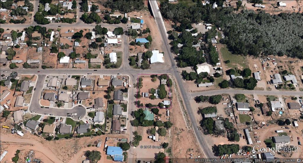
5 MOAB RIM CAMPARK, CUP PH NOVEMBER The site is approximately 20 feet above the highway and adjacent to commercial parcels and a vacant RR parcel to the southwest. 4. Infrastructure Impacts Minimized All utilities are available and approved by the appropriate agencies. Access and drainage has been reviewed and approved by Horrocks Engineers. The Moab Valley Fire Department has not provided approval, although has been working with the applicant on getting approval. Staff anticipates final written approval prior to the meeting. 5. Consistent with the LUC and General Plan The campground meets the use-specific standards outlined in the land use code. The location is within the commercial corridor as identified in the General Plan. 6. Parcel Size No additional acreage is required. Public Notices The public notice for rezone review was posted in the newspaper of general circulation U.C.A a-205 and Land Use Code Sec B.2., posted on site, and the Utah Public Meeting Notice Website at as required for public hearing. IV. Attachments 1. Site Plan, 2. Applicant Narrative 4. Horrocks Review Letter: October 2, Utility Will-serve Letters 6. Aerial Photo PAGE 4
6
7
8
9
10
11

12
13
14 Moab Valley Fire Protection District 45 South 100 East, Moab, Utah Phone: Fax: Commissioners: Chief: Phillip D. Mosher Chairman: William H. Nelson Commissioner: Ernie Lisonbee Commissioner: Tom Shellenberger Assistant Chief: Monte Curtis November 2, 2015 To Whom It May Concern, I have reviewed The Moab Rim RV expansion project with the updated spaces. The proposed project location is within the Moab Valley Fire Protection District. I approve of the expansion plan for this development. Phillip D. Mosher Chief
15 S T A F F R E P O R T MEETING DATE: November 11, 2015 TO: Grand County Planning Commission FROM: Community Development Department SUBJECT: Millcreek RV Park, Conditional Use Application, Colin Fryer Applicant RECOMMENDATION Move to forward a recommendation to the County Council for approval subject to the following conditions being met prior to County Council review: 1. Residential Property Line. Update the site plan indicating screening (opaque fence, wall, berm...) will be located 20 feet from the property line; 2. GWSSA. Provide will serve approval letter; 3. Moab Fire Department. Although staff has had verbal approval by the Fire Chief an approval letters need to be part of the file; 4. Refuse Area. Illustrate on the site plan the area set aside for the dumpster and/or receptacles to comply with Sec F. of the Grand County Land Use Code; 5. Lighting Cut Sheets. Applicant shall provide cut sheets for all exterior lighting to comply with Sec. 6.6 of the Grand County Land Use Code; 6. Compatibility to Surrounding Residential Areas. Due to the proximity to residential properties, two policies will be instituted: BACKGROUND a. No outside burning, and b. Noise curfew of 10:00 p.m. A. General This application is submitted by property owner and project developer, Colin Fryer (Applicant). The project representative is Aaron Lavery. The subject site is zoned Highway Commercial (HC) and consists of approximately 0.92 acres. The Applicant is developing a small RV/campground with full-service sites located on the corner of Holyoak and Arnel Lane. Surrounding properties are zoned HC and Small Lot Residential (SLR), and include commercial and single-family residential uses. The applicant is requesting a conditional use permit and site plan approval for a campground and recreational vehicle (RV) park (LUC Sec L). The proposed site plan includes: 6 full service RV/trailer sites, Office building, Manufactured home for management,
16 MILLCREEK RV CAMPARK, CUP PH NOVEMBER Storage shed. The applicant is requesting a six foot high fence on the south and west side of the property to buffer the site from the residential uses. Fences and walls in nonresidential districts require compliance with Sec. 6.3 C.1. No fence or wall erected within a required front yard shall exceed 6 feet in height. This section conflicts with the buffer requirement, which requires commercial uses to be buffered from residential uses with a visual screening Sec E.1. Planning Commission should decide based on the site plan and discussion below (see view obstruction) whether or not a six foot fence is appropriate. Staff has provided the applicant an alternative method of satisfying these requirements, where the westerly setback is used as parking, and one or more gates provides users entrance into the property. View Obstruction: All fences and walls shall be erected in accordance with Sec , Corner Visibility, which states that no walls, buildings or other obstructions to view in excess of 4 feet in height shall be placed on any corner lot within a triangular area formed by the property line and a line connecting them at points 30 feet from the intersection of the property lines. The County Engineer has concerns regarding the sight distance from the intersection of Mill Creek Dr. and Holyoak Ln., where the project site entrance should be located 125 feet from Mill Creek Ln. Campground & General Development Standards Campground Use-specific Standards Recreational vehicle/ camp parks are a conditional use in the HC zone district. The application complies with the use-specific standards developed for campgrounds found in land use code on pg Each space may be occupied only by persons using travel trailer, truck campers, small cabins (traditional KOA-style) and tents for overnight, short duration or seasonal camping. The site plan shows a fence bisecting the most southern RV space. The RV space will need to be moved to another area on the lot or removed. 2. Each RV / travel trailer space shall be at least 1200 square feet in area. Aside from the staff comment above, all RV spaces are approximately 1200 square feet. 3. Each cabin or tent space shall be at least 800 square feet in area. No cabin sites are proposed 4. Each space shall be at least 30 feet in width. Each space is 30 feet in width. 5. Each park shall be served by public water and sewer facilities. All utilities are available to the site. 6. No space shall be located more than 200 feet from water and sewage service building. RV spaces are full hook-up, which includes water, sewer, and power. 7. The County may require landscaping and screening pursuant to the provisions of Sec. 6.4, Landscaping and Screening. Existing trees on the lot will fulfill this requirement. 8. One tree of a species suitable for the area shall be provided for each two spaces, and shall be located in close proximity to those spaces. (Existing trees on the site may be used to satisfy this requirement.) Application complies. PAGE 2
17 MILLCREEK RV CAMPARK, CUP PH NOVEMBER Site Plan & General Development Standards A. Parking, Loading, and Refuse Areas Each RV space has parking. Additionally, the central parking area meets the specifications for required number of spaces per the land use code: 1 space / 250 square feet of office space = 1 space 2 spaces / residential dwelling = 2 spaces The site plan does not demonstrate the existence of refuse areas (trash cans, recycling bins, large dumpsters.) B. Driveways and Access Facility ingress and egress is Holyoak Lane. Required internal drives are circular on the site plan. Fire Department has approved the site. The County Engineer has concerns regarding the access location on Holyoak Ln. C. Fences and Walls See H. Landscaped Screening and Compatibility Standards below. D. Signs No signage is being proposed F. Lighting The Applicant shall provide cut-sheets meeting the requirements of Sec. 6.6, Lighting prior to building permit approval. G. Drainage The applicant is not proposing more than 7,000 square feet of impervious area and will not need a drainage report, pursuant to Sec. 6.7 of the Land Use Code. H. Compatibility Standards and Landscaped Screening The northern and eastern property line is bound by the HC zone district, the west and southern sides are bounded by SLR, where the applicant plans screening pursuant to Sec. 6.4 of the Land Use Code. I. Operational Performance Standards Compliance with operational performance standards is an ongoing obligation. Impacts on the adjacent single family residence should be given consideration during the site planning process. Planning Commission must consider issues such as late night / early morning noise, parking area lights, and fire/smoke when considering the adequacy of proposed screening and landscaping. Due to the proximity to residential properties a no outside burn and a noise curfew of 10:00 pm policy is advised. J. Utilities Existing utilities are on site, a will serve letter from Grand Water and Sewer Service Agency (GWSSA) and approval of the site plan for required easements is needed. PAGE 3
18 MILLCREEK RV CAMPARK, CUP PH NOVEMBER Conditional Use Permit Standards A conditional use because of its unique characteristics or potential impacts may not be compatible in some areas or may be compatible only if certain conditions are required that reasonably mitigate said impacts. 1. Effect on Environment and 3. External Impacts This site is adjacent to commercial properties to the north and east and residential to the south and west. The applicant will need to provide screening on the westerly property line. The applicant is proposing RV sites along Arnel Lane and requesting approval for a six foot high buffering fence within the setback area. 2. Compatible with Surrounding Area The site is adjacent to residential areas. A policy of no outside burning and a noise curfew of 10:00 PM is advised. 4. Infrastructure Impacts Minimized All utilities are available; a drainage waiver has been approved by Horrocks Engineers. The Moab Valley Fire Department has provided approval. 5. Consistent with the LUC and General Plan The campground meets the use-specific standards outlined in the land use code. The location is within the commercial corridor as identified in the General Plan. 6. Parcel Size No additional acreage is required. Public Notices The public notice for rezone review was posted in the newspaper of general circulation U.C.A a-205 and Land Use Code Sec B.2., posted on site, and the Utah Public Meeting Notice Website at as required for public hearing. PAGE 4
19
20

21 S T A F F R E P O R T DATE: November 11, 2015 TO: FROM: RE: Grand County Planning Commission Planning Staff Conditional Use Application Day Star Adventist Academy RECOMMENDATION Move to forward a recommendation to the County Council for approval subject to the following conditions: Sewer and Water: Approval of the revised septic system for the site. BACKGROUND This application is submitted by Gary Ross, property owner representative (Applicant). The Applicant is requesting an amended Conditional Use Permit approval for rehabilitation of its campus and farm on its 326-acre farm/school in Castle Valley. The subject property is zoned RG, Range and Grazing, as is all the lands surrounding the property. The original CUP amendment to the farm received County approval in Specific expansion plans included construction of the following facilities over the 10 years which followed (staff comment in italics): 1. A girl s dorm, with attached dean s apartment; (a 15 room dorm was constructed) 2. Boys Dorm, with attached Dean s apartment; (not constructed) 3. (Private) 12 RV sites for guests and volunteers not open to the public; (not constructed) Staff housing; (10 single family homes were built on various sites on the property) 5. Grand gateway an elaborate entrance gate; (constructed) 6. Admin building, 4,000 square feet, with worship space and classrooms room quest housing The original CUP had County approval in As the farm and school developed, changes to the siting of buildings were permitted as administrative changes. Recently, the applicant requested additions to the property, which included large agricultural structures. In response, staff requested an updated site plan to include all the current and proposed uses on the site. The applicant s proposed site plan, which includes current and proposed uses, is dated September 14, Staff has reviewed the plan as proposed on September 14, 2015 to avoid confusion as to what was previously approved. No commercial use of the site is allowed, products produced on site are considered to be wholesale products for sale in Moab retail locations and the Moab Farmers Market. Applicable Regulations In order to fairly apply the land use code, it is first necessary to understand and classify the uses proposed onsite. Daystar Adventist Academy includes a combination of farm uses, a permitted use in the RG zone district. A Seventh Day Adventist private boarding school with an onsite campus was established in the 1970 s. Students work on and learn from the farm. Both staff and students live and work on the 300 acre farm. Such Use Types and their associated Accessory Uses are permitted by Conditional Use in the RG zone district. Staff takes no exception to approval of the requested permit.
22 DAY STAR ACADEMY - CUP NOVEMBER 6, 2015 Conditional Uses Conditional Use Permits shall be approved where the County determines there will not be a significant negative impact upon residents of surrounding property or upon the public. The following six criteria shall be considered in the application review: 1. Effect on Environment The location, size, design and operation characteristics of the proposed use shall not be detrimental to the health, welfare, and safety of the surrounding neighborhood or its occupants, nor be substantially or permanently injurious to neighboring property, nor cause substantial or permanent interference with the right to peaceful enjoyment of property. Staff Finding: The subject site is bordered by Castle Valley Town on the east, south, and west, and BLM land to the north. Predominant adjacent uses are large (5+) acre lots used primarily as residences with limited grazing and farming uses. Day Star Adventist Academy s location (RG), size (300 acres), design (consideration of natural environment), and operating characteristics (limited private use for education and farming) compliment adjacent uses. No detrimental impacts are anticipated. 2. Compatible with Surrounding Area The proposed site plan, circulation plan and schematic architectural designs shall be complementary with the character of the surrounding area with relationship to scale, height, landscaping and screening, building coverage, and density. Staff Finding: Project layout and architectural design minimize contrast with the surrounding landscape by utilizing moderately sized structures, earth tone colors, and non-reflective building materials. Day Star Academy is a suitable use for the area and allows Castle Valley residents a short distance to fresh milk, cheese and produce without the need to travel the 30 miles to Moab. 3. External Impacts Minimized The proposed use shall not have negative impacts on existing uses in the area and in the county through the creation of noise, glare, fumes and odors, dust, smoke, vibration, fire hazard, excessive light, or other injurious or noxious impact. The applicant shall provide adequate mitigation responses to these impacts. Staff Finding: No negative external impacts are anticipated. 4. Infrastructure Impacts Minimized The proposed use shall not have negative impacts on existing uses in the area and in the county through impacts on public infrastructure such as roads, parking facilities and water and sewer systems, and on public services such as police and fire protection and solid waste collection, and the ability of existing infrastructure and services to provide services adequately. Staff Finding: Access is from a County Road no additional improvements will be required. Rocky Mountain Power provides power to the site, and the applicant is working with an engineer and the state to upgrade the onsite septic system. Water is provided from wells and springs. 5. Consistent with LUC and General Plan The proposed use will be consistent with the purposes of this LUC, the General Plan, and any other statutes, ordinances or policies that may be applicable, and will support rather than interfere with the uses otherwise permitted in the zone in which it is located. Staff Finding: The proposed use and location are consistent with uses otherwise permitted in the immediate vicinity as well as in the general zone district. Development of the Center supports goals and strategies identified in the current General Plan, including promoting agricultural land uses cultivation of plants and animal raising useful to humans. PAGE 2
23 DAY STAR ACADEMY - CUP NOVEMBER 6, Parcel Size The proposed use may be required to have additional land area, in excess of the lot area otherwise allowed by the underlying zoning district, as necessary to ensure adequate mitigation of impacts on surrounding land uses and the zoning district. Staff Finding: No additional land area is necessary. Site Plan & General Development Standards Parking, Loading, and Refuse Areas Parking sites are internal to the use as campus, farm, and residential. Driveways and Access Facility ingress and egress is Castleton Road and existing. Required internal drives are 20 feet. Fire Department has reviewed the site plan and approved for safety. Signs Highway Commercial district allows for one free standing onsite sign. There is a sign in the UDOT right-of-way used as a directional sign, is not permitted by UDOT. Drainage The County Engineer does not anticipate any problems with drainage on the site. Operational Performance Standards Compliance with operational performance standards is an ongoing obligation. Impacts on the adjacent single family residence should be given consideration during the site planning process. The majority of the school and administrative uses are situated at the top of the 326 acre farm/campus a distance from the single family Castle Valley sites. Utilities Existing utilities are on site, approval letters from the state approving the upgrade to the septic system have not been provided. PAGE 3
24
25
26
27
28

29

30 S T A F F R E P O R T MEETING DATE: TO: FROM: SUBJECT: November 11, 2015, Public Hearing Grand County Planning Commission Planning Staff Application to Rezone Approximately 20 Acres of Property Owned by the Carmichaels, located on Spanish Valley Drive North of Rim Village, from Rural Residential to Small Lot Residential POSSIBLE COURSES OF ACTION Amendments to the zoning map are legislative decisions. The State of Utah grants land use authorities the discretion to make zoning changes with guidance from their general plans, considerations of public health, safety and welfare, and changing community needs. When making a motion and stating reasons for approval or denial the Commission should reference findings for Sec of the Land Use Code (LUC), Issues for Consideration, and consistency with the Future Land Use Plan. Possible courses of action the Commission may elect to follow include: 1. The Commission may forward a recommendation to County Council to approve the rezone, stating reasons for approval. 2. The Commission may forward a recommendation to County Council to deny the rezone, stating reasons for denial. 3. The Commission may table the application for additional comment and review. There are several important factors to consider for rezone applications, which are discussed below. BACKGROUND Introduction This application is submitted by the property owners, Gary and Judy Carmichael (Applicants), who are seeking a rezone from Rural Residential (RR) to Small Lot Residential (SLR). The area proposed for rezone consists of 20 acres of vacant land located on Spanish Valley Drive, north of Rim Village. Surrounding properties are zoned RR (1 unit/acre) and MFR-PUD (2,200 square foot condominium sites). In 1998, at the time of approval, the MFR-PUD was designated as the R-3 zone district and eventually became Rim Village. History Land southeast of the Carmichael property was first classified as R-3 in the 1970s, permitting up to 1 residential unit per 2,200 square foot lot. Today, the R-3 zone district is classified as Small Lot Residential (SLR) with a base zone density of five (5) units per acre. A non-conforming, light industrial business, (Beeman Drilling) used for the storage of equipment is located north of the property in question.
31 REZONE APPLICATION (PC) NOVEMBER 11, 2015 The Rim Village rezone occurred in the 1970s, prior to the adoption of a Future Land Use Plan. During this period, properties were zoned according to existing, on-the-ground activities or based on anticipation of installing public sewer lines. Rim Village was developed in 1998 as a single-family mixed use condominium project with the density of 2,200 square feet per unit as allowed in the 1998 Land Use Code and associated zoning map. To date, the majority of land in Spanish Valley south of Spanish Trail Road is zoned Rural Residential (RR), with the exception of Rim Village. ZONING STANDARDS Use Article 3 of the land use code establishes uses permitted within each zone district. Single-, two-family and town house uses are permitted by right in both the existing (RR) and proposed (SLR) zone districts. The site s access will be Spanish Valley Drive, a major collector street. A rezone to SLR will additionally allow for the development of a manufactured home community by conditional use. Density and Lot Dimension Article 5 establishes densities by zone district. Under the current RR zoning, the subject parcel would accommodate up to 1 unit per acre. The requested zone change to SLR would accommodate between 5 and 7.5 units per acre with any density increases above 5 units per acre requiring both open space and affordable housing. RR single-family standards are designed to accommodate low density, rural neighborhoods. SLR single-family standards will accommodate smaller lots and more compact development. Table 1: A rezone to SLR will allow for a gross maximum density of 100 to 150 dwelling units. Zone District Existing RR Propose d SLR Project Acreage Units Per Acre Total Allowed Density 20 Conventional: 1 20 units 20 Conventional: 5 *Incentive 1: 6.5 *Incentive 2: to 150 units Up-Zone 80 to 130 additional units *A minimum of 50 percent of the bonus dwelling units in Density Incentive 1 and a minimum of 70 percent of the bonus dwelling units in Density Incentive 2 must be affordable housing restricted in accordance with the requirement of Sec of Grand County Land Use Code. Traffic PAGE 2
32 REZONE APPLICATION (PC) NOVEMBER 11, 2015 Spanish Valley Drive is a major north-south collector roadway that runs the length of Spanish Valley and into San Juan County. It is a two-lane unapproved roadway with approximately 26 feet of pavement along its entire length no curb, gutter, or sidewalk. (Spanish Valley Transportation Master Plan, July 2010). Without additional information, Planning Commission should consider the impacts of possible additional traffic on Spanish Valley Drive and other streets within the nearby vicinity. If commuters are looking for quick access to Highway 191, Resource Blvd, Beeman Drive, and Meador Drive through Rim Village may also be impacted with additional traffic. The ITE Trip Generation Manual assumes that single-family homes generate an average of ten daily trips (ADTs) per household. GENERAL PLAN Through the adoption of the 2012 General Plan Update, Grand County adopted a Future Land Use Plan (FLUP) for the first time. The FLUP was the result of numerous public workshops and serves as an important long range planning tool for Grand County, Moab City, SITLA, and special service districts. Adherence to such documents helps enable local entities to ensure adequate availability of public services (e.g. law enforcement, fire, emergency services) and public facilities (e.g. water supply, sewer, roads, drainage). When considering an application to rezone, the Commission should consider consistency with the FLUP. The FLUP designates specific areas within Grand County as appropriate for certain uses and growth. In particular, The FLUP calls for small lots and compact housing near Moab City with decreasing tiers of density and rural development patterns further out. Figure 4.15, Future Land Use Plan Spanish Valley designates the land south of Spanish Trail Road, including the subject parcel, as Rural Residential. LAND USE CODE Rezoning is a discretionary decision, meaning the County may reasonably decide the request either way. In addition to the policies outlined in the General Plan and Future Land Use Plan, the Land Use Code offers further guidance in Sec 9.2.7, Issues for Consideration. The Applicant s response to each issue is provided in attached materials. Staff comments are provided below. A positive finding with respect to each issue is not required. Sec Issues for Consideration 1. Was the existing zone for the property adopted in error? No, the parcel has been historically used as a rural alfalfa field, which is an allowed use in the RR zone district. PAGE 3
33 REZONE APPLICATION (PC) NOVEMBER 11, Has there been a change of character in the area (e.g. installation of public facilities, other zone changes, new growth trends, deterioration, development transitions, etc.)? Sewer and water lines were extended in the 1980s. The Spanish Valley Transportation Master Plan identifies deficiencies on Spanish Valley Drive, such as curb, gutter, road widths and suggests recommended improvements, including widening of Spanish Valley Drive to three lanes. The County has developed Old Spanish Trail Arena (OSTA) into a secondary community park, including soccer fields and ball parks. Prior to the adoption of a Future Land Use Plan, the parcel adjacent to the Carmichael parcel was rezoned to a MFR (R-3) zone district which has developed into a condominium and townhome development. In 2009, Grand County and Moab City adopted an Interlocal Affordable Housing Study and Plan, which outlined the growing need for housing units affordable to moderate- and lowincome households. One tool, among many, for increasing the availability of affordable housing units is to increase housing densities. Nevertheless, smart growth planning theory and current knowledge of long-term infrastructure maintenance, transportation, social, and healthcare costs dictate that compact development near commercial centers has many advantages. Staff encourages Planning Commission to engage in a healthy conversation about the merits of this rezone application in light of the Moab Area s increasing affordability gap and affordable housing deficit, as well as future growth patterns in the Spanish Valley area of Grand County. 3. Is there a need for the proposed use(s) within the area or community? Smaller more compact development is needed close town. Such development limits vehicle miles traveled, promotes efficient infrastructure (and maintenance), and enables people to live close to where they work and obtain goods and services. In 2012 the General Plan addressed this need through the adoption of a Future Land Use Plan (FLUP), The FLUP designates areas for potential growth and increased residential density. 4. Will there be benefits derived by the community or area by granting the proposed rezoning? Benefits derived from the proposed up-zone include: additional housing stock, increased development rights for the property owner, and possibly increased property taxes for Grand County. Granting the proposed rezone in its current form does not guarantee that any of the long term benefits outlined in the General Plan and Land Use Code necessary to support an increase in residential density will be addressed. These include: preservation of rural character (through either clustered development, varying lot sizes, or open space), multimodal transportation, proximity to town, or an affordable housing component. 5. Is the proposal in conformance with the policies, intents and requirements of Grand County General Plan, specifically the Plan s zoning map amendment guidelines? The proposed rezone is not supported by the Future Land Use Plan or the vision, goals, and strategies identified in the General Plan. The applicant s statement lists a number of the goals and strategies of the FLUP, however, it does not explain how the proposed rezone supports them. PAGE 4
34 REZONE APPLICATION (PC) NOVEMBER 11, Should the development be annexed to a City? No, the City does not provide any services. 7. Is the proposed density and intensity of use permitted in the proposed zoning district? Single-family detached housing and two-family duplex or townhomes are permitted by right in the SLR zone district. A rezone to SLR will additionally allow for the development of a manufactured home community by conditional use. 8. Is the site suitable for rezoning based on a consideration of environmental and scenic quality impacts? Staff assumes the rezone would facilitate a conventional lot subdivision. Such an outcome would affect the overall scenic quality of the area, as it would transform an alfalfa field to a residential subdivision. However, staff recognizes that Rim Village to the south, a high density commercial condominium development to the north has already created significant visual and traffic impacts on the area. In recent years, Grand County has also approved the development of the Old Spanish Trail Arena. In the near future, a proposed USU campus to the north will inevitably create visual and traffic impacts on the south-us 191 and Spanish Valley Drive corridors. Of course, granting a substantial increase in residential density in an area farther from town than identified in the FLUP s infill or transitional zones, will result in indirect environmental impacts such as increased traffic on roads and additional sewer and water needs. 9. Are the proposed uses compatible with the surrounding area or uses; will there be adverse impacts; and/or can any adverse impacts be adequately mitigated? Conventional subdivision in the SLR zone permits 5 units per acre (8,700 sq. ft. lots). With the exception of the condominium development located at Rim Village, lots south of Spanish Trail Road have been developed to RR one unit per acre density. The vast majority of lots south of Spanish Trail Road remain one acre or greater in size. 10. Are adequate public facilities and services available to serve development for the type and scope suggested by the proposed zone? If utilities are not available, could they be reasonably extended? Is the applicant willing to pay for the extension of public facilities and services necessary to serve the proposed development? Staff anticipates all public facilities and services necessary to serve the development will be available. GWSSA and the County Road Department have not provided letters for the ability to serve the additional units or the expense to extend or upgrade the services. 11. Does the proposed change constitute spot zoning? The best way to avoid spot zoning is to make rezoning decisions based on the FLUP, future growth patterns, and community needs. Public Notices The public notice for rezone review was posted in the newspaper of general circulation U.C.A a-205 and Land Use Code Sec B.2., posted on site, and the Utah Public Meeting Notice Website at as required for public hearing. Additional a public notice was sent by mail to property owners within 100 feet of the proposed rezone. PAGE 5

35 REZONE APPLICATION (PC) NOVEMBER 11, 2015 PAGE 6

36
37 DRAFT Grand County Planning Commission Minutes October 14, 2015 A regular meeting of the Grand County Planning Commission convened on the above date in the Grand County Courthouse, 125 East Center. Members Present: Chair Dave Tubbs, Mike Duncan, Gerrish Willis, and Dave Cozzens. Absent: Joe Kingsley, Ryan McCandless, and Kalen Jones. Staff Present: Mary Hofhine, Zacharia Levine Council Liaison: Mary McGann The Chair convened the meeting at 6:05 PM and asked that all cell phones be turned off or silenced. The Chair asked if there were any conflicts of interest or exparte that needed to be disclosed. There were none. Citizens to be Heard none Final Plat review for Courthouse Wash Commercial Subdivision and PUD The County Council approved the preliminary plat for the Courthouse Wash Commercial PUD on August 4 th in a public hearing. Final plat submitted meets the provisions of Article 7 Subdivision Standards, and the issues raised during the preliminary platting process have been addressed. The County attorney is finalizing the Master Association Agreement and the CC&R s, cost estimates, and bonding amounts have been approved by the County Engineer. The Commission discussed the bonding, shared parking, clarifications on common area and open space. With no other discussion the Chair called for a motion. Gerrish Willis moved to send a favorable recommendation to the County Council for approval of the Courthouse Wash Commercial Subdivision and PUD. Dave Cozzens seconded and all voted in favor. Public Hearing Proposed Conditional Use application for an ATV/UTV Tours, Sales and Repair in a General Business District. This application is submitted by Dave Engleman, property owner. The applicant is requesting conditional use approval for ATV/UTV Sales, Service and Tours. The repair service is conditional use permit (Sec. 3.1 Use Table). The applicant is the owner of the building and is planning to lease the building for proposes of ATV/UTV tours, sales, and services. The property is located at 854 So. Main, Highway 191 and is zoned General Business (GB). Access is through an easement between the Farm and City Feed Store and the Eastern Credit Union. Adjacent properties to the north and south are also zoned GB, the adjacent property to the back is City C-4. The RV Sales and service is a permitted use in the GB zone district, the conditional uses are guide services and repair garage. The proposed use and site plan conforms in operation, location, and construction to the performance standards. The applicant s site plan has met the criteria for approval including Fire Department Approval, UDOT permit for access, adjacent property compatibility, parking requirements, Horrocks approved the drainage, and utilities are on site. The Chair opened the public hearing. Kevin Walker has concerns about the noise from the UTV and cautioned the Commission approving another rental business. External impacts of the neighbors are the noise and additional traffic, he suggests a moratorium until the County and City decide on a solution. Killey Miller agrees that the noise of ATV/UTV s need to be addressed by the County and the City. Planning Commission / October 14, of 3 DRAFT- unapproved
38 Kathy Holyoak is an adjacent neighbor to the current Moab 4X4 that rents and repairs ATV/UTV s and doesn t find that the noise is intolerable, they are in a business zone district. Enforcement of noise and speed needs to happen on the City and County roadways. Ronnie Dressey stated that all UTV/ATV s come with allowable noise level muffler systems; it s the aftermarket installations that cause the noise, which is a law enforcement issue. Mary McGann said there is a committee that has been discussing the noise problems of ATV/UTV s on the County and the City neighborhoods. Chairman Tubbs stated that this is a universal problem of dust and noise not specific to the site in discussion for the conditional use. Mike Duncan confirmed that the use of sales and rental is a permitted use, the repair garage is the conditional use. With no other discussion, the Chair entertained a motion. Dave Cozzens moved to forward a favorable recommendation to the County Council for the Moab Side by Side Adventures Conditional Use with the following conditions: Outdoor storage shall be screened from view with an 8 foot sight obscuring fence. Mike Duncan seconded and all voted in favor. The public hearing was closed. Public Hearing Proposed code amendment to create a hearing officer position and remove the Board of Adjustment. Grand County has had a difficult time filling positions to the Board of Adjustment, Grand County s Appeal Authority. Staff has reviewed Land Use Code and red-lined the changes that will need to be made in order to amend the code. Also proposed amendments to the County Fee Schedule to accommodate the fees for a hearing officer. The Utah Code Annotated 17-27a-611 allows for a single person hearing officer as the Appeal Authority and Grand County desires to change the Appeal Authority from a Board of Adjustment to a single hearing officer. The Grand County Council will appoint the Hearing Officer and contract the service and base the fee on the approved County Fee Schedule. The Commission has had workshops to discuss the proposed code amendment; this is the public hearing as required by the Land Use Code for code amendments. The Chair opened the public hearing and asked if there were any citizens that would like to speak on the subject. There were none. Gerrish Willis noted an error reference in the draft ordinance and noted the modification. Gerrish Willis moved to forward a favorable recommendation to the County Council for the code amendment to change the Appeal Authority from a board of Adjustment to a single hearing office as corrected. Mike Duncan seconded and all voted in favor. The public hearing was closed. Public Hearing Proposed code amendment to eliminate the required public hearing process for preliminary subdivision plat review and conditional use review. In order to streamline the development process while preserving adequate opportunity for public comments, staff has amended the Land Use Code procedure for preliminary plat and conditional use permit reviews. Recommended changes to preliminary plat review include: a) Replacing the public hearing with a public meeting to be held by Planning Commission, and b) Removing County Council review of the public hearing. A single public meeting for preliminary plat is required by state statute; staff is suggesting that the public meeting would be with the Planning Commission. Planning Commission / October 14, of 3 DRAFT- unapproved
39 Notice of public meetings for subdivision will require a posting on the site of the subdivision or mail or notice to the each parcel within a specific parameter of the property and posted on the state site. Recommended amendments to conditional use permit review include: a) Replacing the public hearing held by Planning Commission with a public meeting. Applicants will have one public meeting with Planning Commission and one public hearing with County Council. State law requires no specific notice for conditional use permits. In anticipation of potentially controversial applications, Planning Commission recommended at their meeting on August 26 th, 2015 that a public hearing be required at the County Council after a public meeting review by Planning Commission. Also included are clean-up of submittal requirements in Sections 9.4 and 9.11, requiring electronic submittals and decrease the hard copies. Gerrish Willis recommended a clarification to public hearing posting to add 10 consecutive days prior to the hearing for posting. The Chair opened the public hearing and asked if there were any citizens that would like to speak on the subject. There were none. The Commission has reviewed and discussed the changes to the code in workshops and had directed staff to provide changes as discussed for the public hearing. Gerrish Willis moved to forward a favorable recommendation to the County Council as corrected. Dave Cozzens seconded. The Chair asked for discussion on the motion. Being none, the Chair called for a vote. All voted in favor of the motion. The Chair closed the public hearing. Approval of Minutes: September 23, 2015 minutes were approved as written. Future Considerations: none Community Development Department Update: CRMP funding update, will be attending the ALG with Lynn Jackson to discuss funding of the CRMP. Zacharia will be giving a Housing Presentation at the joint meeting of the County/City Council on Oct. 30. Staff will be attending the Land Institute Seminar on October 27 and 28 th, we are canceling the Planning Commission meeting on the 28 th. County Council Liaison report: Ms. McGann gave a brief update of the Council meeting. Adjournment - meeting adjourned at 8:15 PM Planning Commission / October 14, of 3 DRAFT- unapproved
GRAND COUNTY Planning Commission May 11, :00 P.M. Regular Meeting Grand County Courthouse Council Chambers 125 E Center, Moab, Utah
 Type of Meeting: Facilitator: Attendees: Regular Meeting Dave Tubbs, Chair GRAND COUNTY Planning Commission May 11, 2016 6:00 P.M. Regular Meeting Grand County Courthouse Council Chambers 125 E Center,
GRAND COUNTY Planning Commission June 22, :00 P.M. Regular Meeting Grand County Courthouse Council Chambers 125 E Center, Moab, Utah
 Type of Meeting: Facilitator: Attendees: Regular Meeting Dave Tubbs, Chair GRAND COUNTY Planning Commission June 22, 2016 6:00 P.M. Regular Meeting Grand County Courthouse Council Chambers 125 E Center,
4.2 RESIDENTIAL ZONING DISTRICTS
 4.2 RESIDENTIAL ZONING DISTRICTS A. Purpose: To define regulations and standards for each residential zoning district in the City. The following sections identify uses, regulations, and performance standards
ARTICLE 7. SPECIFIC USE STANDARDS
 ARTICLE 7. SPECIFIC USE STANDARDS Section 7.1 Applicability The following standards apply to specified uses in all zoning districts in which such uses are allowed. Section 7.2 Accessory Apartments (A)
City of Valdosta Land Development Regulations
 Chapter 206 Section 206-1 Base Zoning Districts Standards for Uses, Structures, and Property Development (B) (C) Principal Uses and Structures. Principal uses and structures permitted in each base zoning
ARTICLE XI CONDITIONAL USE PERMITS
 ARTICLE XI CONDITIONAL USE PERMITS 11.1 Purpose. The City of Hailey recognizes that certain uses possess unique and special characteristics with respect to their location, design, size, method of operation,
TOWN OF ORO VALLEY PLANNING & ZONING COMMISSION MEETING DATE: December 6, 2011
 PLANNING & ZONING COMMISSION MEETING DATE: December 6, 2011 TO: FROM: SUBJECT: PLANNING & ZONING COMMISSION Matt Michels, Senior Planner mmichels@orovalleyaz.gov; tel. 229-4822 Public Hearing: Rancho de
ARTICLE 15 - PLANNED UNIT DEVELOPMENT
 Section 15.1 - Intent. ARTICLE 15 - PLANNED UNIT DEVELOPMENT A PUD, or Planned Unit Development, is not a District per se, but rather a set of standards that may be applied to a development type. The Planned
PLANNING COMMISSION STAFF REPORT
 PLANNING COMMISSION STAFF REPORT West Capitol Hill Zoning Map Amendment Petition No. PLNPCM2011-00665 Located approximately at 548 W 300 North Street, 543 W 400 North Street, and 375 N 500 West Street
Watkinsville First Baptist Church Building and Parking Masterplan Norton Road & Simonton Bridge Road Oconee County Georgia
 Watkinsville First Baptist Church Building and Parking Masterplan Norton Road & Simonton Bridge Road Oconee County Georgia Special Use Approval A-1 CUP to A-1 with Special Use Approval Total Site Area
Financial Impact Statement There are no immediate financial impacts associated with the adoption of this report.
 STAFF REPORT Planning and Development Department Subject: Application by RYC Property to rezone a portion of lands on John Murray Dr. and Megan Lynn Dr. from R2 to R3 and to enter into a Development Agreement
Cover Letter with Narrative Statement
 Cover Letter with Narrative Statement March 31, 2017 rev July 27, 2017 RE: Rushton Pointe Residential Planned Unit Development Application for Public Hearing for RPUD Rezone PL2015 000 0306 Mr. Eric Johnson,
Glades County Staff Report and Recommendation Unified Staff Report for Small Scale Plan Amendment and Rezoning
 Glades County Staff Report and Recommendation Unified Staff Report for Small Scale Plan Amendment and Rezoning CASE NUMBERS: COMP17-02 and RZ17-02 DATE of STAFF REPORT: May 1, 2017 CASE TYPE: Application
Glades County Staff Report and Recommendation REZONING
 Glades County Staff Report and Recommendation REZONING CASE NUMBER: RZ15-01 DATE: October 2, 2015 CASE TYPE: Application for Rezoning REQUEST: J.J. Wiggins Memorial Trust is requesting a rezoning of 22.1±
AGENDA ITEM SUMMARY GLADES COUNTY BOARD OF COUNTY COMMISSIONERS
 AGENDA ITEM SUMMARY GLADES COUNTY BOARD OF COUNTY COMMISSIONERS SUBJECT: Case Number COMP17-01, Legend Moto LLC This is a Legislative Hearing. DEPARTMENT REQUEST: The Community Development Department requests
ARTICLE IV: DEVELOPMENT STANDARDS
 ARTICLE IV: DEVELOPMENT STANDARDS IV-53 409 PRIVATE STREETS A private street means any way that provides ingress to, or egress from, property by means of vehicles or other means, or that provides travel
The following regulations shall apply in the R-E District:
 "R-E" RESIDENTIAL ESTATE DISTRICT (8/06) The following regulations shall apply in the R-E District: 1. Uses Permitted: The following uses are permitted. A Zoning Certificate may be required as provided
ADMINISTRATIVE HEARING STAFF REPORT
 ADMINISTRATIVE HEARING STAFF REPORT Providence Place Apartments Utility Box No. 2 Conditional Use Petition PLNPCM2011-00426 309 East 100 South September 22, 2011 Planning and Zoning Division Department
(if more than one, give square footage for each) ANNEXATION LOT LINE Adjustments PRE/FINAL PLAT SPECIAL USE PERMIT
 ANNEXATION LOT LINE Adjustments PRE/FINAL PLAT SPECIAL USE PERMIT") Planning Commission Application Building & development office 915 Third ST. Rawlins WY ph. 307-328-4599 fax. 307-328-4590 PROJECT REVIEW: GENERAL INFORMATION Project name: OFFICE USE ONLY Site address
Planning Commission Application Building & development office 915 Third ST. Rawlins WY ph. 307-328-4599 fax. 307-328-4590 PROJECT REVIEW: GENERAL INFORMATION Project name: OFFICE USE ONLY Site address
Understanding the Conditional Use Process
 Understanding the Conditional Use Process The purpose of this document is to explain the process of applying for and obtaining a conditional use permit in the rural unincorporated towns of Dane County.
1. Cuyler-Brownsville planned neighborhood conservation (P-N-C) districtphase I (section ). (2) Single-family semiattached dwellings;
 districtphase I (section ). (2) Single-family semiattached dwellings;") Sec. 8-3035. Planned unit development multifamily (PUD-M). A. Purpose. The PUD-M district is intended to allow a variety of residential development including single-family residential, two-family residential,
Sec. 8-3035. Planned unit development multifamily (PUD-M). A. Purpose. The PUD-M district is intended to allow a variety of residential development including single-family residential, two-family residential,
1. Roll Call. 2. Minutes a. September 24, 2018 Special Joint Meeting with Clay County Planning Commission. 3. Adoption of the Agenda
 1. Roll Call City of Vermillion Planning Commission Agenda 5:30 p.m. Regular Meeting Tuesday, October 9, 2018 City Council Chambers 2 nd Floor City Hall 25 Center Street Vermillion, SD 57069 2. Minutes
A Affordable Storage CUP Amendment, in Section 20, T35N R2W NMPM, at 4340B US Hwy 160W and 122 Meadows Dr.
 Archuleta County Development Services Planning Department 1122 HWY 84 P. O. Box 1507 Pagosa Springs, Colorado 81147 970-264-1390 Fax 970-264-3338 MEMORANDUM TO: Archuleta County Planning Commission FROM:
PLANNING COMMISSION REPORT Regular Agenda Public Hearing Item
 PC Staff Report 11/12/12 Item No. 2B- 1 PLANNING COMMISSION REPORT Regular Agenda Public Hearing Item ITEM NO. 2B: A TO GPI; 110 ACRES; E OF K-10 & N OF W 6 TH ST (MKM) : Consider a request to rezone approximately
Draft Zoning Changes for the 2nd Planning Board Public Hearing, January 22, 2018.
 Draft Zoning Changes for the 2nd Planning Board Public Hearing, January 22, 2018. No changes were made at the 1st Public Hearing. Proposed wording for the 1 st Public Hearing in red, eliminated text in
ADUs and You! Common types of ADUs include mother-in-law suite, garage apartments and finished basements.
 ADUs and You! Accessory Dwelling Units Town of Lyons Accessory Dwelling Units (ADUs) are a form of housing that can be an important tool for diversifying and increasing the local housing stock. Lyons lost
Planning Department Oconee County, Georgia STAFF REPORT
 Planning Department Oconee County, Georgia STAFF REPORT REZONE CASE #: 7332 DATE: November 28, 2017 STAFF REPORT BY: Gabriel Quintas, Planner APPLICANT NAME: Smith Planning Group PROPERTY OWNER: John Hadden
Planned Unit Development (PUD). Sections:
. Sections:") Chapter 19.07. Planned Unit Development (PUD). Sections: 19.07.01. Purpose. 19.07.02. PUD Definition and Design Compatibility. 19.07.03. General PUD Standards. 19.07.04. Underlying Zones. 19.07.05. Permitted
Chapter 19.07. Planned Unit Development (PUD). Sections: 19.07.01. Purpose. 19.07.02. PUD Definition and Design Compatibility. 19.07.03. General PUD Standards. 19.07.04. Underlying Zones. 19.07.05. Permitted
STAFF REPORT And INFORMATION FOR THE HEARING EXAMINER
 KITSAP COUNTY DEPARTMENT OF COMMUNITY DEVELOPMENT 614 DIVISION STREET MS-36, PORT ORCHARD WASHINGTON 98366-4682 Louisa Garbo, Director (360) 337-7181 FAX (360) 337-4925 HOME PAGE - www.kitsapgov.com/dcd/
UPPER MOUNT BETHEL TOWNSHIP NORTHAMPTON COUNTY, PENNSYLVANIA
 UPPER MOUNT BETHEL TOWNSHIP NORTHAMPTON COUNTY, PENNSYLVANIA JOINDER DEED / LOT CONSOLIDATION TOWNSHIP REVIEW PROCESS When accepting proposed Joinder Deeds / Lot Consolidations, review the Joinder Deed
CITY OF SANTA ROSA COMMUNITY DEVELOPMENT DEPARTMENT STAFF REPORT FOR PLANNING COMMISSION SEPTEMBER 10, 2015 APPLICANT FILE NUMBER MJP
 ITEM NO. 9 CITY OF SANTA ROSA COMMUNITY DEVELOPMENT DEPARTMENT STAFF REPORT FOR PLANNING COMMISSION SEPTEMBER 10, 2015 PROJECT TITLE Yogurt Time Center ADDRESS/LOCATION 3093 Marlow Road ASSESSOR S PARCEL
ARTICLE VII. NONCONFORMITIES. Section 700. Purpose.
 ARTICLE VII. NONCONFORMITIES. Section 700. Purpose. The purpose of this chapter is to regulate and limit the development and continued existence of legal uses, structures, lots, and signs established either
Marion County Board of County Commissioners
 Marion County Board of County Commissioners Date: 12/29/2015 P&Z: 12/28/2015 BCC: 1/12/2016 Item Number 160113Z Type of Application Rezoning Request From: A-1 (General Agriculture) To: PUD (Planned Unit
REPORT TO PLANNING AND DESIGN COMMISSION City of Sacramento
 REPORT TO PLANNING AND DESIGN COMMISSION City of Sacramento 915 I Street, Sacramento, CA 95814-2671 www.cityofsacramento.org 9 PUBLIC HEARING December 10, 2015 To: Members of the Planning and Design Commission
Cobb County Community Development Agency Zoning Division 1150 Powder Springs St. Marietta, Georgia 30064
 Cobb County Community Development Agency Zoning Division 1150 Powder Springs St. Marietta, Georgia 30064 Case # Z-63 Public Hearing Dates: PC: 11-06-18 BOC: 11-20-18 SITE BACKGROUND Applicant: Loyd Development
AGENDA. a. Carol Crews Special Exception Hair Salon (Continued from February) b. James Barber Special Exception Horse
 b. James Barber Special Exception Horse") Baker County Land Planning Agency (LPA) Thursday, April 23, 2015 Baker County Administration Building 55 North Third Street Macclenny, FL 32063 (904) 259-3354 AGENDA 5:OO P.M. LDR Mining Workshop A. Draft
Baker County Land Planning Agency (LPA) Thursday, April 23, 2015 Baker County Administration Building 55 North Third Street Macclenny, FL 32063 (904) 259-3354 AGENDA 5:OO P.M. LDR Mining Workshop A. Draft
Staff Report: Date: Applicant: Property Identification: Acreage of Request: Current Zoning of Requested Area: Requested Action: Attached:
 Staff Report: Completed by Jeff Palmer Director of Planning & Zoning Date: November 7, 2018, Updated November 20, 2018 Applicant: Greg Smith, Oberer Land Developer agent for Ronald Montgomery ET AL Property
Residential Project Convenience Facilities
 Standards for Specific Land Uses 35.42.220 E. Findings. The review authority shall approve a Land Use Permit in compliance with Subsection 35.82.110.E (Findings required for approval) or a Conditional
DIVISION 1 PURPOSE OF DISTRICTS
 ARTICLE 2 ZONING DISTRICTS AND MAP DIVISION 1 PURPOSE OF DISTRICTS Section 2.101 Zoning Districts. For the purpose of this Ordinance, the City of Richmond is hereby divided into districts as follows: DISTRICT
City of San Juan Capistrano Agenda Report. Honorable Mayor and Members of the City Council. Joel Rojas, Development Services Director ~ )P
P") 10/17/2017 F1b TO: FROM: SUBMITTED BY: City of San Juan Capistrano Agenda Report Honorable Mayor and Members of the City Council ~n Siegel, City Manager Joel Rojas, Development Services Director ~ )P PREPARED
10/17/2017 F1b TO: FROM: SUBMITTED BY: City of San Juan Capistrano Agenda Report Honorable Mayor and Members of the City Council ~n Siegel, City Manager Joel Rojas, Development Services Director ~ )P PREPARED
APPLICATION FOR SPECIAL USE PERMIT PLEASE SUBMIT 7 COMPLETE PACKETS
 GOODING COUNTY PLANNING AND ZONING COMMISSION 145 7 TH Avenue East PO Box 417 Gooding, Idaho 83330 Phone: (208) 934-5958 Fax: (208) 934-4363 www.goodingcounty.org/p&z.htm OFFICE USE ONLY: APPLICATION COMPLETE:
O-I (Office-Institutional) and AG-1(Agricultural)
 and AG-1(Agricultural)") PROPERTY INFORMATION ADDRESS 3503 and 3505 Bethany Bend DISTRICT, LAND LOTS 2/1 973 and 974 OVERLAY DISTRICT State Route 9 PETITION NUMBERS EXISTING ZONING O-I (Office-Institutional) and AG-1(Agricultural)
PROPERTY INFORMATION ADDRESS 3503 and 3505 Bethany Bend DISTRICT, LAND LOTS 2/1 973 and 974 OVERLAY DISTRICT State Route 9 PETITION NUMBERS EXISTING ZONING O-I (Office-Institutional) and AG-1(Agricultural)
Planning Department Oconee County, Georgia
 Planning Department Oconee County, Georgia STAFF REPORT REZONE CASE #: 6985 DATE: October 31, 2016 STAFF REPORT BY: Andrew C. Stern, Planner APPLICANT NAME: Williams & Associates, Land Planners PC PROPERTY
STAFF REPORT. Financial Impact Statement There are no immediate financial impacts associated with the adoption of this report.
 STAFF REPORT Planning and Development Department Subject: Cottage Country Unsubstantial Amendment to Development Agreement To: CAO for Planning Advisory Committee, December 13, 2016 Date Prepared: December
Staff Report: Date: Applicant: Property Identification: Acreage of Request: Current Zoning of Requested Area: Requested Action: Attached:
 Staff Report: Completed by Jeff Palmer Director of Planning & Zoning Date: November 7, 2018 Applicant: Greg Smith, Oberer Land Developer agent for Ronald Montgomery ET AL Property Identification: Frontage
REVISED # Federal Drive Milestones Therapy Project Review for Planning and Zoning Commission
 REVISED #2012-111 394 Federal Drive Milestones Therapy Project Review for Planning and Zoning Commission Meeting Date: November 7, 2012 and November 19, 2012 Request: Location: Acreage: Existing Zoning:
CITY PLAN COMMISSION STAFF REPORT
 CITY PLAN COMMISSION STAFF REPORT SUBJECT: Request for a Change of Zoning and Preliminary Development Plan FROM: Mara Perry, Director of Planning & Development MEETING DATE: November 6, 2017 PETITION:
New Cingular Wireless Telecommunication Tower at County Road 48, Milner Conditional Use Permit
 New Cingular Wireless Telecommunication Tower at 39415 County Road 48, Milner ACTIVITY #: Conditional Use Permit PP2012-023 HEARING DATES: Planning Commission (PC): August 16, 2012 at 6:00pm PETITIONER:
Staff Report PLANNED DEVELOPMENT. Salt Lake City Planning Commission. From: Lauren Parisi, Associate Planner; Date: December 14, 2016
 Staff Report PLANNING DIVISION COMMUNITY & NEIGHBORHOODS To: Salt Lake City Planning Commission From: Lauren Parisi, Associate Planner; 801-535-7932 Date: December 14, 2016 Re: 1611 South 1600 East PLANNED
Operating Standards Attachment to Development Application
 Planning & Development Services 2255 W Berry Ave. Littleton, CO 80120 Phone: 303-795-3748 Mon-Fri: 8am-5pm www.littletongov.org Operating Standards Attachment to Development Application 1 PLANNED DEVELOPMENT
THE REDEVELOPMENT PLAN
 PAGE 37 THE REDEVELOPMENT PLAN FUTURE LAND USE The Silver Terrace Redevelopment Area is currently designated as Redevelopment Area #4 on the City of Delray Beach Future Land Use Map (FLUM). This designation
THE CITY OF RAYMORE, MISSOURI Single-Family Residential Zoning Districts
 THE CITY OF RAYMORE, MISSOURI Single-Family Residential Zoning Districts REGULATIONS COMMON TO ALL DISTRICTS: Uses permitted in each district include detached single-family dwellings, manufactured homes
MINNETONKA PLANNING COMMISSION June 2, A conditional use permit for 2,328 square feet of accessory structures at 4915 Highland Road
 MINNETONKA PLANNING COMMISSION June 2, 2016 Brief Description A conditional use permit for 2,328 square feet of accessory structures at Recommendation Recommend the city council adopt the resolution approving
Urban Planning and Land Use
 Urban Planning and Land Use 701 North 7 th Street, Room 423 Phone: (913) 573-5750 Kansas City, Kansas 66101 Fax: (913) 573-5796 Email: planninginfo@wycokck.org www.wycokck.org/planning To: From: City Planning
Request Conditional Use Permits (Open-Air Market, Assembly Use) Staff Planner Robert Davis
 Staff Planner Robert Davis") Applicant Property Owner Burrows Family Revocable Trust Public Hearing September 14, 2016 City Council Election District Princess Anne Agenda Item 6 Request Conditional Use Permits (Open-Air Market, Assembly
Applicant Property Owner Burrows Family Revocable Trust Public Hearing September 14, 2016 City Council Election District Princess Anne Agenda Item 6 Request Conditional Use Permits (Open-Air Market, Assembly
4-1 TITLE 6 MOBILE HOME AND RECREATIONAL VEHICLE PARKS 4-3
 4-1 TITLE 6 MOBILE HOME AND RECREATIONAL VEHICLE PARKS 4-3 Chapter 4 RECREATIONAL VEHICLE PARKS Sec. 4-1: Sec. 4-2: Sec. 4-3: Sec. 4-4: Sec. 4-5: Sec. 4-6: Sec. 4-7: Sec. 4-8: Sec. 4-9: Sec. 4-10: Sec.
Chapter 100 Planned Unit Development in Corvallis Urban Fringe
 100.100 Scope and Purpose. Chapter 100 Planned Unit Development in Corvallis Urban Fringe (1) All applications for land divisions in the Urban Residential (UR) and Flood Plain Agriculture (FPA) zones within
PLANNING COMMISSION REPORT Regular Agenda Public Hearing Item
 CUP-15-00474 Item No. 5-1 PC Staff Report 11/16/15 ITEM NO. 5 PLANNING COMMISSION REPORT Regular Agenda Public Hearing Item CONDITIONAL USE PERMIT FOR PUBLIC WHOLESALE WATER SUPPLY DISTRICT NO. 25; E 1300
PLANNING COMMISSION STAFF REPORT
 PLANNING COMMISSION STAFF REPORT REZONING CASE: RZ-15-002 REPORT DATE: January 26, 2016 CASE NAME: Thursday Lunch Club Rezoning PLANNING COMMISSION DATE: February 17, 2016 ADDRESS OF REZONING PROPOSAL:
RE: 6. GILL/GREEN COMPREHENSIVE PLAN AMENDMENT, REZONING AND PRELIMINARY PLAT
 commission memo DATE: Thursday - August 9, 2018 TO: Marion Planning & Zoning Commission FROM: David N. Hockett, AICP Principal Planner RE: 6. GILL/GREEN COMPREHENSIVE PLAN AMENDMENT, REZONING AND PRELIMINARY
AAAA. Planning and Zoning Staff Report Lake Shore Land Holdings, LLC CU-PH Analysis
 AAAA Planning and Zoning Staff Report Lake Shore Land Holdings, LLC CU-PH2016-28 Hearing Date: April 21, 2016 Development Services Department Applicant: BRS Architects/Cindy Huebert Staff: Kyle McCormick,
APPENDIX D: DEFINITIONS
 D APPENDIX D: DEFINITIONS Terms used throughout the 2040 Comprehensive Plan should be interpreted using the definitions provided in this appendix. For interpretation of any term not defined, defer to the
SUBJECT: Application for Planned Unit Development and Rezoning 1725 Winnetka Road
 TO: FROM: CHAIRMAN BILL VASELOPULOS AND MEMBERS OF THE PLAN & ZONING COMMISSION STEVE GUTIERREZ DIRECTOR OF COMMUNITY DEVELOPMENT MEETING DATE: September 5, 2017 SUBJECT: Application for Planned Unit Development
PERMITTED USES: Within the MX-1 Mixed Use Neighborhood District the following uses are permitted:
 6.25 MX-1 - MIXED USE NEIGHBORHOOD 6.25.1 INTENT: The purpose of the MX-1 Mixed Use Neighborhood District is to accommodate the development of a wide-range of residential and compatible non-residential
REPORT OF THE PLANNING AND DEVELOPMENT DEPARTMENT FOR APPLICATION FOR REZONING ORDINANCE TO PLANNED UNIT DEVELOPMENT MAY 18, 2017
 BEL REPORT OF THE PLANNING AND DEVELOPMENT DEPARTMENT FOR APPLICATION FOR REZONING ORDINANCE 2016-805 TO PLANNED UNIT DEVELOPMENT MAY 18, 2017 The Planning and Development Department hereby forwards to
Town of Cary, North Carolina Rezoning Staff Report 14-REZ-31 Cary Park PDD Amendment (Waterford II) Town Council Meeting January 15, 2015
 Town Council Meeting January 15, 2015") Town of Cary, North Carolina Rezoning Staff Report 14-REZ-31 Cary Park PDD Amendment (Waterford II) Town Council Meeting January 15, 2015 REQUEST To amend the Town of Cary Official Zoning Map by amending
Town of Cary, North Carolina Rezoning Staff Report 14-REZ-31 Cary Park PDD Amendment (Waterford II) Town Council Meeting January 15, 2015 REQUEST To amend the Town of Cary Official Zoning Map by amending
ZONING ORDINANCE: OPEN SPACE COMMUNITY. Hamburg Township, MI
 ZONING ORDINANCE: OPEN SPACE COMMUNITY Hamburg Township, MI ARTICLE 14.00 OPEN SPACE COMMUNITY (Adopted 1/16/92) Section 14.1. Intent It is the intent of this Article to offer an alternative to traditional
LAND USE AND ZONING OVERVIEW
 OVERVIEW OF PLANNING POLICIES LAND USE AND ZONING OVERVIEW The Minneapolis Plan for Sustainable Growth and Other Adopted Plans Community Planning and Economic Development Development Services Division
CHAPTER 14 PLANNED UNIT DEVELOPMENTS
 9-14-1 9-14-1 CHAPTER 14 PLANNED UNIT DEVELOPMENTS SECTION: 9-14-1: Purpose 9-14-2: Governing Provisions 9-14-3: Minimum Area 9-14-4: Uses Permitted 9-14-5: Common Open Space 9-14-6: Utility Requirements
PLANNING COMMISSION STAFF REPORT. Merrimac PLNSUB Planned Development 38 West Merrimac November 9, Request. Staff Recommendation
 PLANNING COMMISSION STAFF REPORT Merrimac PLNSUB2011-00374 Planned Development 38 West Merrimac November 9, 2011 Planning and Zoning Division Department of Community and Economic Development Applicant:
COMMERCIAL ZONING DISTRICTS (Amended 11/13/14) Part I. C-1 Restricted Commercial District
 Part I. C-1 Restricted Commercial District") ARTICLE XI. COMMERCIAL ZONING DISTRICTS (Amended 11/13/14) Part I. C-1 Restricted Commercial District Section 152: Purpose This district is designed to accommodate commercial uses which act as a transition
ARTICLE XI. COMMERCIAL ZONING DISTRICTS (Amended 11/13/14) Part I. C-1 Restricted Commercial District Section 152: Purpose This district is designed to accommodate commercial uses which act as a transition
THE AREA PLAN COMMISSION OF ST. JOSEPH COUNTY, IN AGENDA
 THE AREA PLAN COMMISSION OF ST. JOSEPH COUNTY, IN AGENDA Tuesday, January 17, 2017 Fourth-Floor Council Chambers 3:30 p.m. County-City Building, South Bend, IN EXECUTIVE SESSION: A. Election of Officers
REPORT TO THE SHELBY COUNTY PLANNING COMMISSION From the Department of Development Services Planning Services. February 4, 2019
 REPORT TO THE SHELBY COUNTY PLANNING COMMISSION From the Department of Development Services Planning Services February 4, 2019 Case No. Request for Rezoning Approval From E-1 to E-2 SD This is a request
MINUTES JOINT MEETING LINCOLN COUNTY and SIOUX FALLS PLANNING COMMISSIONS 7:00 pm July 14, 2010
 MINUTES JOINT MEETING LINCOLN COUNTY and SIOUX FALLS PLANNING COMMISSIONS 7:00 pm July 14, 2010 Commissioners Room - Lincoln County Court House A joint meeting of Lincoln County and Sioux Falls Planning
PROPOSED AMENDMENTS TO THE DERBY ZONING REGULATIONS AUGUST 12, 2008
 ARTICLE II Definitions and word usage 195-7. Definitions and word usage. Modify the following: HOUSING FOR THE ELDERLY OLDER PERSONS Housing in accordance with and as defined in the United States Fair
APPLICANT NAME SUBDIVISION NAME DEVELOPMENT NAME LOCATION. CITY COUNCIL DISTRICT Council District 4 PRESENT ZONING PROPOSED ZONING
 SUBDIVISION, PLANNED UNIT DEVELOPMENT, PLANNING APPROVAL, ZONING AMENDMENT, & SIDEWALK WAIVER REQUEST STAFF REPORT Date: February 17, 2010 APPLICANT NAME SUBDIVISION NAME DEVELOPMENT NAME LOCATION David
CHAPTER 14 SPECIAL DEVELOPMENTS
 10-14-1 10-14-1 CHAPTER 14 SPECIAL DEVELOPMENTS SECTION: 10-14-1: Cluster and Inner Block Development 10-14-2: Planned Unit Development 10-14-1: CLUSTER AND INNER BLOCK DEVELOPMENT: A. Land Use: Cluster
ARTICLE 2 ZONING DISTRICTS AND MAPS
 ARTICLE 2 ZONING DISTRICTS AND MAPS SECTION 2.100 PURPOSE OF DISTRICTS Section 2.101. For the purpose of this Ordinance, Billings Township is hereby divided into districts as follows: DISTRICT NAME SYMBOL
A Guide to the Municipal Planning Process in Saskatchewan
 A Guide to the Municipal Planning Process in Saskatchewan A look at the municipal development permit and the subdivision approval process in Saskatchewan May 2008 Prepared By: Community Planning Branch
FOR OFFICE USE ONLY Date Submitted Received By Fees Paid $ Receipt No. Received By Application No. Application Complete Final Action Date
 COMMERCIAL, INDUSTRIAL, & MANUFACTURING SITE PLAN (CIM) APPLICATION Mariposa County Planning Department 5100 Bullion Street, P.O. Box 2039 Mariposa, CA 95338 Telephone (209) 966-5151 FAX (209) 742-5024
ORDINANCE NO The Town Council of the Town of Yucca Valley does ordain as follows:
 ORDINANCE NO. 141 AN ORDINANCE OF THE TOWN COUNCIL OF THE TOWN OF YUCCA VALLEY, CALIFORNIA, AMENDING TITLE 8, DIVISION 12, CHAPTER 1 RELATING TO DEFINITIONS AND TITLE 8, DIVISION 8, CHAPTER 3, RELATING
NOTICE OF MEETING AND AGENDA FOR THE PLANNING COMMISSION OF SPRINGVILLE, UTAH... JANUARY 23, 2018
 NOTICE OF MEETING AND AGENDA FOR THE PLANNING COMMISSION OF SPRINGVILLE, UTAH............................ JANUARY 23, 2018 Notice is hereby given that the Planning Commission will hold a public meeting
CITY OF NAPLES STAFF REPORT
 Meeting of 05/13/15 Conditional Use Petition 15-CU3 CITY OF NAPLES STAFF REPORT To: Planning Advisory Board From: Planning Department Subject: Conditional Use Petition 15-CU3 Petitioner: Hazelden Betty
SUBDIVISION, PLANNED UNIT DEVELOPMENT, PLANNING APPROVAL, ZONING AMENDMENT, & SIDEWALK WAIVER REQUEST STAFF REPORT Date: February 17, 2010
 SUBDIVISION, PLANNED UNIT DEVELOPMENT, PLANNING APPROVAL, ZONING AMENDMENT, & SIDEWALK WAIVER REQUEST STAFF REPORT Date: February 17, 2010 APPLICANT NAME SUBDIVISION NAME DEVELOPMENT NAME LOCATION David
Washington County, Minnesota Ordinances
 Washington County, Minnesota Ordinances Ordinance No. 153 Text Amendment to the Washington County Development Code - Chapter One, Section 2 and Chapter Two, Part 1, Part 2, Part 3, of the Development Code
In order to permit maximum applicability of the PUD District, PUD-1 and PUD-2 Districts are hereby created.
 ARTICLE III. PUD ned Unit Development Overlay District 205-128. Purpose. The PUD ned Unit Development Overlay District is intended to provide flexibility in the design of planned projects; to encourage
REPRESENTATIVE: Julie & Brad Nicodemus Black Squirrel Road Colorado Springs, CO 80809
 COMMISSIONERS: DARRYL GLENN (PRESIDENT) MARK WALLER (PRESIDENT PRO TEMPORE) STAN VANDERWERF LONGINOS GONZALEZ PEGGY LITTLETON PLANNING AND COMMUNITY DEVELOPMENT DEPARTMENT CRAIG DOSSEY, EXECUTIVE DIRECTOR
MINUTES JOINT MEETING LINCOLN COUNTY and SIOUX FALLS PLANNING COMMISSIONS 7:00 pm August 10, 2011
 MINUTES JOINT MEETING LINCOLN COUNTY and SIOUX FALLS PLANNING COMMISSIONS 7:00 pm August 10, 2011 Commissioners Room - Lincoln County Court House A joint meeting of the Lincoln County and Sioux Falls Planning
Article Optional Method Requirements
 Article 59-6. Optional Method Requirements [DIV. 6.1. MPDU DEVELOPMENT IN RURAL RESIDENTIAL AND RESIDENTIAL ZONES Sec. 6.1.1. General Requirements... 6 2 Sec. 6.1.2. General Site and Building Type Mix...
NOTICE OF PUBLIC HEARING.
 NOTICE OF PUBLIC HEARING. In accordance with Tennessee Code Annotated Section 13-7- 105, the Board of County Commissioners of Blount County, Tennessee, will convene and hold public hearing on August 12,
BARROW COUNTY, GEORGIA
 BARROW COUNTY, GEORGIA Application For Rezoning, Special Use, and Change in Conditions BARROW COUNTY DEPARTMENT OF PLANNING AND DEVELOPMENT 30 North Broad Street Winder, Georgia 30680 770-307-3034 APPLICATION
MINUTES OF THE JOINT MEETING MINNEHAHA COUNTY & DELL RAPIDS PLANNING COMMISSIONS August 28, 2017
 MINUTES OF THE JOINT MEETING MINNEHAHA COUNTY & DELL RAPIDS PLANNING COMMISSIONS August 28, 2017 A joint meeting of the County and City Planning Commissions was held on August 28, 2017 at 7:00 p.m. in
Clearcreek Township Zoning Staff Report Soraya Farms Section 6 Stage 3 Review Page 1 of 8
 Staff Report: Completed by Jeff Palmer Director of Planning & Zoning Report Date: September 10, 2018 Meeting Date: October 1, 2018 Applicant: Shery Oakes, agent for Soraya Farms Requested Action: Soraya
AGENDA ITEM SUMMARY GLADES COUNTY BOARD OF COUNTY COMMISSIONERS
 AGENDA ITEM SUMMARY GLADES COUNTY BOARD OF COUNTY COMMISSIONERS SUBJECT: Case Number COMP17-02, RFYC, LLC This is a Legislative Hearing. DEPARTMENT REQUEST: The Community Development Department requests
Division Development Impact Review.
 Division 51-4.800. Development Impact Review. SEC. 51-4.801. PURPOSE. The general objectives of this division are to promote and protect the health, safety, and general welfare of the public through the
Business Park District Zoning Text Amendment (PLNPCM ) ZONING TEXT AMENDMENT
 ZONING TEXT AMENDMENT") Staff Report PLANNING DIVISION COMMUNITY & ECONOMIC DEVELOPMENT To: Salt Lake City Planning Commission From: Maryann Pickering, Principal Planner (801) 535-7660 Date: June 10, 2015 Re: Business Park District
Staff Report PLANNING DIVISION COMMUNITY & ECONOMIC DEVELOPMENT To: Salt Lake City Planning Commission From: Maryann Pickering, Principal Planner (801) 535-7660 Date: June 10, 2015 Re: Business Park District
Conditional Use Permit case no. CU 14-06: Bristol Village Partners, LLC
 PLANNING AND ZONING COMMISSION STAFF REPORT August 7, 2014 Conditional Use Permit case no. CU 14-06: Bristol Village Partners, LLC CASE DESCRIPTION: LOCATION: LEGAL DESCRIPTION: EXISTING LAND USE: ZONING:
Legal Description Part of the Western Half of the Eastern Half of the Northwest Quarter of Section 30, Le Ray Township
 Owner and Applicant s 20448 State Highway 83 Mankato, MN 56001 Request and Location Request for review and approval of a Conditional Use Permit to allow an Elder Care Residential Unit to be constructed
ZONING HEARING BOARD APPLICANTS
 ZONING HEARING BOARD APPLICANTS All applications to the Manheim Township Zoning Hearing Board shall include all of the following information. 1. One (1) application form (no copies needed), signed by the
DESOTO COUNTY PLANNING AND ZONING DEPARTMENT STAFF REPORT
 DESOTO COUNTY PLANNING AND ZONING DEPARTMENT STAFF REPORT REQUEST: PROPERTY OWNER: APPLICANT: AGENT: SE 2014-02 Felix & Maria Zapata Felix & Maria Zapata Same N/A PROPERTY: 35-38-24-0116-0010-0090 TOTAL