*1. Trudy Halverson NE W4 Bylaw 1/2018 Further Consideration of Conditions
|
|
|
- Stephanie Cooper
- 5 years ago
- Views:
Transcription
1 MUNICIPAL DISTRICT OF FOOTHILLS NO. 31 April 18, 2018 Location: M.D. of Foothills Administration Office 309 Macleod Trail South High River COUNCIL AGENDA A. GENERAL MATTERS 1. Call Meeting to Order 2. Approval of the Agenda as Distributed 3. Consideration of Additions to the Agenda 4. Minutes April 11, Accounts April 18, 2018 B. PUBLIC WORKS/ENGINEERING C. PUBLIC HEARINGS & MEETINGS Drew Granson Pg. 3 10:00 am *1. Dirt Cheep SE W4 Development Permit 18D 018 Brenda Bartnik Pg :30 am *2. Hyland Consultants Ltd. Alberta Distributed Power Corp SW W4 Development Permit 18D :00 am 3. Spitzee Riparian Society Presentation Management Plan D. MISCELLANEOUS PLANNING ITEMS Pg. 28 *1. Trudy Halverson NE W4 Bylaw 1/2018 Further Consideration of Conditions E. SUBDIVISION APPROVING AUTHORITY ITEMS Pg. 35 Pg. 67 *1. Jeffrey Langford SW W4 Acknowledgement of MGB Order *2. Sincerus GP Ltd. (Hawks Springs) E W5 Request for Time Extension F. MISCELLANEOUS MUNICIPAL ITEMS 1. Name Change to Foothills County Public Consultation G. POSTPONED ITEMS H. NEW BUSINESS 1. Committee Reports
2 I. OTHER MATTERS 1. Adjourn 2. Next Meeting April 25, 2018 at 9:00 am 3. April Accounts Review Councillors: R. Siewert, R.D. McHugh and S. Oel

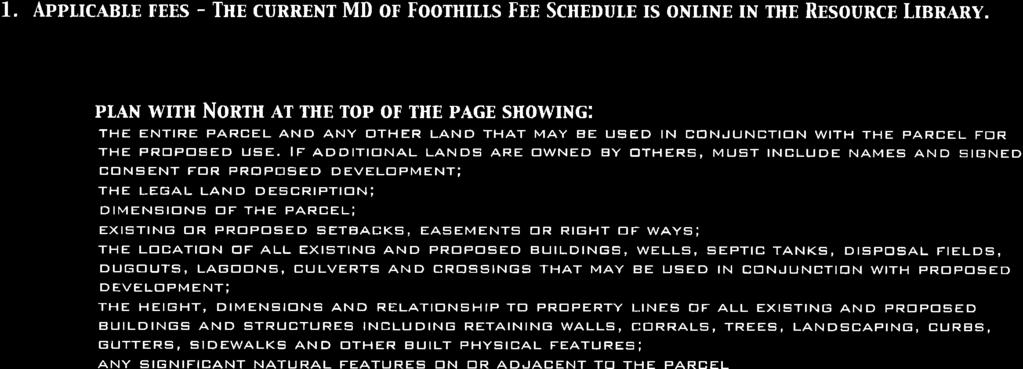
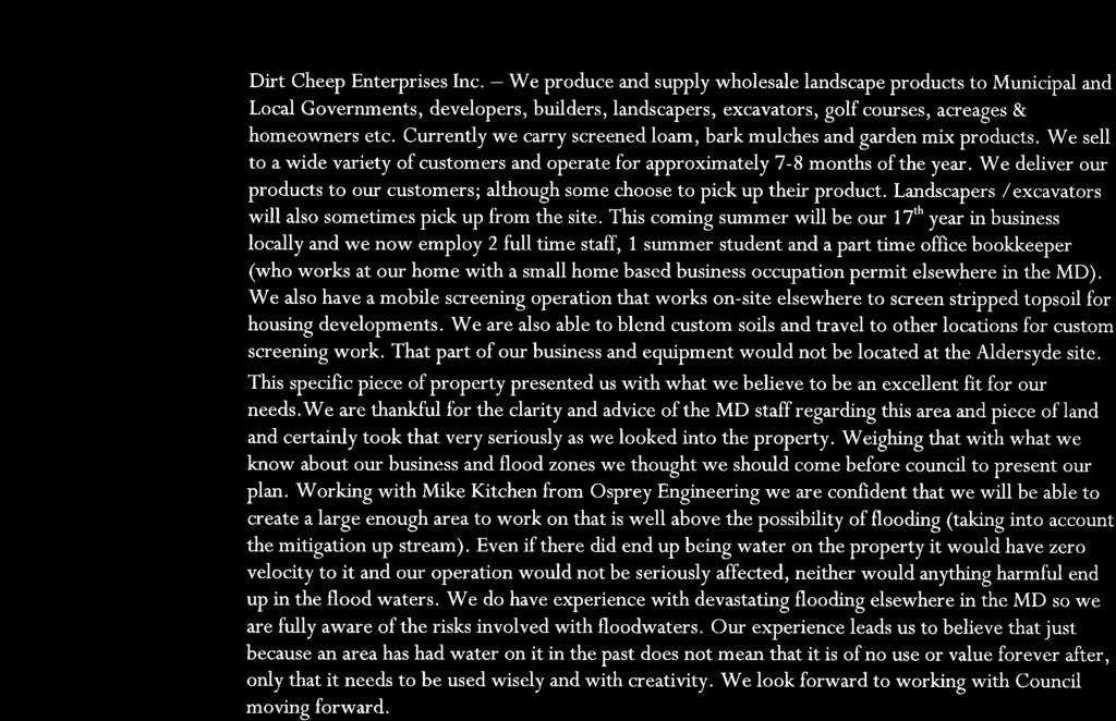
3 DEVELOPMENT PERMIT APPLICATION PLANNING AND DEVELOPMENT REPORT DIRECT CONTROL DISTRICT #16 April 18, 2018 LANDOWNER: Dirt Cheep Enterprises Inc. LEGAL DESCRIPTIONS: Portion of SE W4M PARCEL SIZE: /- Acres DEVELOPMENT PERMIT NUMBER: 18D 018 APPLICANT: Joey & Kimberly Boutin EXISTING LAND USE: Direct Control District #16 - DC16 DIVISION: #1 Rob Siewert FILE MANAGER: Drew Granson PROPOSAL: The application is for Development Permit 18D 018 that requests the issuance of a Development Permit under Direct Control District #16. The applicant has proposed to operate a Wholesale Landscape Product Business and Tree Farm on the subject property. As Council is the development authority for Direct Control District lands, they shall decide on all applications for development permits, and may approve an application for the issuance of a development permit, with or without conditions. Note: The proposed use is neither a permitted or discretionary use within DC16; therefore, should Council support the proposed use under Development Permit 18D 018, a Land Use Amendment to DC16 would be required prior to the issuance of this Development Permit. LOCATION: The subject property is a 9.65 acre Direct Control District #16 parcel and is located directly west of 2431 Drive East. This is directly southwest of Highway 2, approximately 700 meters west of the Highwood River, and approximately 1.7 kilometers southwest of the Hamlet of Aldersyde. PROPOSAL: The submitted application proposes to allow for Dirt Cheep Enterprises Inc., a wholesale landscape material supplier, to operate on the subject property. On site operations are proposed to consist of storage and wholesales of bark mulches, loam, and garden mix products, as well as a tree farm. Administrative operations occur off site within the applicants dwelling which was previously approved under Development Permit for Minor Home Occupation. A maximum of 6 employees are expected to attend the property at any given time, consisting of the applicants, two full time employees and two summer students. Hours of operation are identified as Monday to Friday 7:30am 5:30pm, and Saturdays 8:00am 3:00pm, and closed on Sundays, and the applicants have noted that deliveries by employees of Dirt Cheep may occur later than 5:30 on weekdays. The business is seasonal, proposing to operate from April 1 st to November 30 th, and is dependent on weather. The applicants have proposed to complete lot grading, designed by a Professional Engineer, consisting of cutting into the existing slope to flatten the property and installation of a retaining wall and landscaping berm along the northwest, north and east boundaries, with a mix of Spruce, Poplars, Saskatoon bushes, Juniper, Cotoneaster, Potentilla and boulders to provide screening from Highway 2. Approximately 3-4 acres within the southern portion of the property is proposed to be planted as a tree farm and applicants have proposed approximately 4,500-6,000 trees, depending on species and ability to obtain approved water source. An area of approximately 3
4 30x30 meters is proposed to be enclosed by black chain link security fencing, for secure overnight parking of on-site equipment and would contain a small accessory building with staff bathroom proposed to be run by solar power mounted to the structure. Traffic associated with the business is proposed to consist of 5-15 tandem trucks and pickup trucks per day, and 2-3 deliveries of mulch per week. One 4 x4 identification sign is proposed to be located near the south corner of the property. SITE INSPECTION The subject property is generally flat and primarily grassland with shrubs throughout. A portion of an oxbow lake which was formerly the Highwood River. Three existing approaches provide access to the subject property, and Public Works has requested that two approaches be removed and ditches remediated, and the central approach to be upgraded to commercial standards. POLICY AREA: The proposal is not within an Area Structure Plan, Outline Plan, or Area Redevelopment Plan and has therefore been reviewed within the terms of the MDP2010, Growth Management Strategy, and the Land Use Bylaw. In addition, the subject property is located within the Flood Hazard Protection Overlay District. POLICY & PLANNING CONSIDERATIONS MDP 2010: Policy 2 in the Economy Section of the MDP2010 reads: 2. Proposals for commercial or industrial developments in addition to Natural Resource Extraction should be developed to be compatible with the surrounding area and existing land use. Consideration shall be given to size, design, noise, odor traffic, dust, and the visual impact of the proposed on the adjacent lands. Proposals shall also be considered on the basis of the following criteria: 2.1. Appropriate transportation and utility infrastructure Land use conflicts are minimized Impact on adjoining lands Reasonable privacy is afforded to residents 2.5. Design does not preclude the possible development of adjoining lands Retention of the natural site features Efficiency of use of land. GROWTH MANAGEMENT STRATEGY This parcel falls within the Central District of the Growth Management Strategy. Growth Management Vision for the Central District: The Central District of the MD has been the growth engine for the MD and this trend is expected to continue into the future. While significant development and intensification of development is expected in this area, it will need to be undertaken bearing in mind the aspirations of our municipal neighbours and with due consideration to riparian and wetland areas. Opportunities for joint initiatives will play a key role in providing effective, efficient, and affordable services for this area. LAND USE BYLAW: SECTION DIRECT CONTROL DISTRICT #16 (DC16) Purpose and Intent: 4
5 To allow Direct Control by Council over the development of the following lands: Plan , Block 1, Ptn. N.W W4M Ptn. S.E W4M PERMITTED USES Nil DISCRETIONARY USES Category A Accessory Buildings Accessory Use Administrative Offices Camping Dirt Track Racing Driving Schools Mud Bogs Parking Safety Training Show and Shines Signage Storage of Ground Maintenance Equipment Vehicle Fabrication Facility for Racetrack Only Vehicle Repair Facility for Racetrack Only Warm Storage of Vehicles for Racetrack Only Category B (Event Specific) Auctions Banquets Birthday Parties Concerts Corporate Functions Cutting Horse Futurities Dances Fashion Shows Festivals Flea Markets and Swap Meets Fundraisers for Charity Graduation Parties Movie Productions Music Competitions and Recitals Music Videos Rodeo Events R.V. Shows Team Cattle Penning Weddings REQUIREMENTS: Standard of the development shall be at the discretion of Council. Note: Direct Control District #16 was created for the purpose of allowing for a Racetrack facility and related uses on adjacent lands. These properties are not currently operating any racetrack or related activities. Should Council support the proposed use, a land use amendment to DC16 would be necessary to include the proposed uses as either permitted or discretionary uses. CIRCULATIONS Western Wheel AER Public Works Advertised April 4 th and 11 th, Applicant has provided the Municipality declaration no abandoned wells exist within the parcel. A well and pipeline containing H2S are located within 500 meters of the subject property. The applicant shall ensure setbacks of 100 meters from the centerline of pipeline and 100 meters from the centre of the wellhead are maintained. Stormwater Management Plan with consideration of 1:100 year flood level, Comprehensive Site Drainage Plan, and Lot Grading Plan to be reviewed and accepted by Public Works. Two existing approaches off of 2431 Drive East shall be removed and ditches remediated, and middle approach to be upgraded to Commercial Approach Standards with Culvert. Proposed Retaining Walls to be designed by professional engineer and shall 5
6 Alberta Transportation Alberta Health Services Alberta Environment be considered and reviewed within required Stormwater Management Plan. Applicant will be required to enter into a Road Use Agreement with the MD. A Roadside Development Permit is required from Alberta Transportation prior to the issuance of a Development Permit from the MD of Foothills. No objection subject to following: The applicant/operator must ensure the property is designed and maintained in accordance with the Alberta Public Health Act (RSA 2000), Nuisance and General Sanitation Regulation 243/2003 which states: No person shall create, commit or maintain a nuisance. A nuisance means a condition that is or might become injurious or dangerous to the public health, or that might hinder in any manner the prevention or suppression of disease. This application appears to impact what could be (or possibly has been) a crown claimable waterbody under section 3 of the Public Lands Act. Alberta Environment may have claim to this wetland. Application to the Water Boundaries Unit should be made by the applicant for this determination. Municipal Fire Must adhere to AB Fire Code : Storage of mulch, wood chips, and hogged materials shall not exceed 15,000 m 2 and must maintain minimum setback of 15 meters from any building. Applicants to maintain access to property for fire apparatus. Septic/Safety Codes Applicable Building and Safety Codes permits and inspections required for proposed bathroom structure and solar equipment for proposed use and occupancy. OPTIONS FOR CONSIDERATION: Following are two (2) possible options for Council s consideration: OPTION #1: APPROVAL Council may choose to grant approval for a Development Permit with the accompanying conditions and/or with revised conditions of their choosing. Note: Council may wish to provide any of the following conditions, or any additional conditions, as a pre-release condition(s) should they be of the opinion that the requirement be addressed prior to the Development Permit being issued. Please provide a timeline or deadline for the pre-release condition(s) to be fulfilled. Should the pre-release condition(s) not be adhered to within the provided timeline, the decision would become null and void. CONDITIONS FOR COUNCIL S CONSIDERATION: Recommended Pre-Release Conditions: (Conditions must be fulfilled prior to the Development Permit being endorsed) 1) Land Use Amendment to Direct Control District #16 to allow for the proposed uses within this district shall obtain 3 rd and final reading prior to the issuance of this development permit. Failure to obtain appropriate land use approvals for this property will see this decision considered null and void; 2) The applicant is required to submit a Stormwater Management Plan prepared by a Professional Engineer, including provisions for proposed berm and retaining walls, and 6
7 addressing 1:100 year flood levels, for review and acceptance by the Municipal Public Works Department and Alberta Environment; 3) The applicant shall obtain Road Side Development Permit from Alberta Transportation and provide proof of such to the Development Authority; 4) The application is required to enter a Road Use Agreement with the Municipal Public Works and Engineering Department; 5) The applicant is required to submit a refundable security deposit in the amount of $5,000 in order to ensure compliance with conditions of this approval herein; Additional Recommended Conditions: 6) Upon completion of the Pre-Release Conditions, this approval will allow for the operation of a Wholesale Landscape Product Business and Tree Farm; 7) Landscaping, screening, and stormwater facilities shall at all times be maintained as per the plan(s) accepted to be appropriate by the municipality and must at all times be safe, functional, and in a good state of repair. The property shall at all times have a generally neat and orderly appearance. Plants are to be maintained to demonstrate healthy and vigorous growth; 8) This approval allows for the construction of a staff bathroom structure. The proposed structure is to be located as identified in the accepted site plan, and must adhere to all municipal setback requirements. The applicants must adhere to all requirements of the Alberta Building and Safety Code, and obtain all necessary permits including building, plumbing, gas, septic, and electrical permits. Proof of such must be submitted to the Development Authority; 9) It is the applicant s responsibility to adhere to all recommendations and requirements of Alberta Transportation; 10) Two existing approaches off of 2431 Drive East shall be removed and ditches remediated and the middle approach shall be upgraded to Commercial Approach Standards with Culvert to the satisfaction of the Municipal Public Works and Engineering Department; 11) The applicants must obtain an annual Business Licence from the M.D. of Foothills No.31; 12) Hours the operation is permitted to be open to the public are approved as follows: Mondays through Fridays - 7:30am 5:30pm; Saturdays - 8:00am 3:00pm, and closed on Sundays; 13) A maximum of six (6) employees are permitted to be working on site at any given time; 14) A maximum of forty (40) vehicle trips are permitted on any given day. This includes all employee trips, customers, and any deliveries to or from the subject property; 15) All parking stalls, laneways, aisles, and loading spaces shall be developed to the size and specifications as outlined in Section 9.19 of the Land Use Bylaw; 16) Stockpiling of materials shall adhere to all applicable requirements of the Alberta Fire Codes; 17) Prior to installation of any signage, it is the applicants responsibility to provide design and location specifics to be reviewed and accepted by the Development Authority. In addition, the applicant is responsible for obtaining all necessary approvals from Alberta Transportation with respect to signage; proof of such shall be provided to the Development Authority; 18) The applicant shall comply with all applicable requirements of Alberta Environment with respect to water use and shall obtain all required licenses and/or approvals from AEP, proof of such shall be provided to the Development Authority; 19) Installation(s) of exterior lighting must adhere to the guidelines and technical specifications as outlined within the M.D. of Foothills Dark Sky Bylaw; 7
8 20) No offensive noise, vibration, smoke, dust, odor, heat, glare, electrical, and/or radio disturbance is to be detectable beyond the boundary of the lot; 21) The development must meet all requirements of Alberta Health Services and Alberta Environment, including that all waste materials must be disposed of at an approved waste disposal site. There shall be no long term storage of waste materials on the property, nor burning of waste materials on the property. All garbage and recycling materials shall be stored in weather-proof and animal-proof containers that are required to be visibly screened from adjacent lands and roadways; 22) Prior to the Municipality acknowledging completion of the development, it is the responsibility of the applicant to submit as-built drawings by the respective Professional Engineer verifying all improvements are consistent with the plans and recommendations within the abovementioned Stormwater Management Plan, as accepted by the Municipality; 23) Recommendations within the submitted Stormwater Management Plan shall be adhered to when designing and locating any fencing and landscaping on the subject property; 24) Issuance of a development permit by the municipality does not relieve the applicant of the responsibility of complying with all other relevant municipal bylaws and requirements, nor excuse violation of any provincial or federal regulation or act which may affect use of the land and/or the storage of materials on the property; 25) The applicants indemnify and hold harmless the Municipality against the cost of any claims or actions, or awards for loss or damage to the Owner(s) arising from the use of the subject property; 26) The applicants shall be responsible for payment of any professional costs, including legal fees that may be incurred by the Municipal District with respect to the development approved under this permit. 27) Contravention of any of the above conditions may result in this permit being considered null and void; OPTION #2: REFUSAL Council may choose to refuse the application for a Development Permit if it is of the opinion that the application does not satisfactorily conform to those policies that guide use within the Direct Control District #16; ENCLOSURES: Location Map Lot Ortho Submitted Site Plan Submitted Site Cross Section Submitted Landscaping/Screening Plan Submitted Application and Business Description 8

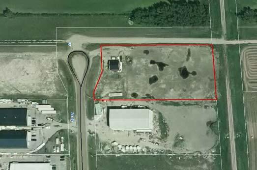
9 9 Subject Parcel

10 Subject Parcel 10
11 SUBMITTED SITE PLAN 11
12 SUBMITTED SITE CROSS SECTION 12
13 PROPOSED LANDSCAPING/SCREENING PLAN 13

14 14

15 15

16 16
17 17

18 PUBLIC MEETING APPLICATION FOR DEVELOPMENT PERMIT18D 038 DIRECT CONTROL DISTRICT #2 April 18 th, 2018 at 10:30 AM LANDOWNER: Hyland Consultants Ltd. LEGAL DESCRIPTION: Plan Lot 14 SW W4 EXISTING PARCEL: 1.96 acres NUMBER OF PROPOSED NEW PARCELS: N/A APPLICANT: Alberta Distributed Power Corp. DIVISION: #1 Rob Siewert EXISTING LAND USE: Direct Control District #2 FILE MANAGER: Brenda Bartnik PROPOSAL: Request to allow for the operation of a peak power generation plant for a period of 12 months in order to test the feasibility of plant location and connection to the provincial power grid. The applicant has requested a public meeting in order to be present and able to address any questions with Council. LOCATION: The subject property is located on the east side of 82 nd Street east, within the Abild s Industrial Park that lies adjacent to the east side of Highway #2A, approximately two and one-half miles north of the Town of High River. POLICY AREA: The property is located within the Highway 2A Industrial Area Structure Plan (H2AIASP) area and development is guided by the Municipal Development Plan and the Highway 2A Industrial Area Structure Plan under the Industrial Commercial (IC) policy area. Enhanced Design and Landscaping guidelines apply. BACKGROUND: Lot 14 of the Abild s Industrial Park was subdivided under Phase 2 of the subdivision in Municipal sewer and water services are provided to the property as per agreement with the Town of High River approval of Development Permit 03D 205 included construction of one 32 x 36 ft. private hobby use workshop (hobby woodworking shop). Between approximately 2008 and 2015, operations occurred on the east side of the lot that included the storing, blending and screening of landscaping materials (soils and compost), in absence of obtaining appropriate permits to do so. At the time of site inspection for this application on April 2, 2018, it could be noted that two sea-cans exist on the parcel, in absence of a development permit. 18
19 SITE CONSIDERATIONS: Access The lot is accessed off of Highway 2A via 466 th Avenue east. An approach exists from 82 nd Street east. Natural Features Site features are generally unremarkable. The property s north side lies adjacent to a municipal road plan that is anticipated to be developed to a municipal standard in the near future. The lot is bordered on the west by 82 nd Street, and on the east by the Canadian Pacific Railway. The north boundary of the lot encompasses a 10m utility right of way that runs east/west. Improvements The property is serviced by municipal water and wastewater. One building, having a footprint of 1,152 sq. ft. is located on the lot. A row of deciduous columnar trees has been planted along the west property line. PROPOSAL: Alberta Distributed Power Corp is proposing to locate a natural gas power generation plant on the subject property, for a duration of 12 months, in order to test plant location and connection to the provincial power grid. The plant is to generate power during times of peak power demand and feed it back to the grid. The application states that this peak demand installation would run approximately 1,400 hours per year, or 16% of the time. It is most likely to turn on between 7:00 AM and 7:00 PM, with some hours between 7:00 PM and 11:00 PM during hot summer days, or possibly under circumstances like during a shut down of a main power plant. The applicant is requesting approval for use of the property as follows: o Two containers are to be bolted together to form a larger container (12m x 8m) covering an area of 1,034 sq. ft., which is to be placed on existing grade. The containers store natural gas powered generators and other electrical equipment to operate the power generation equipment. An external, pad-mounted transformer, approximately 2m x 2m x 2m in size is to be located on the street side of the containers. o The generation containers and generators are connected to the gas supply and power feeder lines. A power line is proposed to run from the transformer to a power pole within the property and be connected via overhead line to the power grid, on a pole that is approximately 50m from the generation equipment. A radio antennae may be located on the pole located within the property. Plant operation is monitored around the clock using internet connected video, audio and control systems. o Company owners will monitor the power generation operations and third party contractors are to maintain the power generation equipment. Operations are monitored at all times via live audio, video and control system feedback. Monitoring includes fire and natural gas detectors, and generation capacity is to be limited to 1 MW. Following initial installation, the property will be accessed in order to perform monthly inspections lasting approximately two hours, and semi-annual maintenance lasting approximately five hours. For these purposes, a maintenance truck will attend the lot. o The generator/radiator loop is a self-contained system that uses standard ethylene glycol based coolant. o The facility operates periodically as demanded and controlled by the power grid. Hours of operation are unpredictable. Historically, 2-3 days per year it could be 8 hours continuous, otherwise an average maximum of 4 hours continuous operation 4-5 days at a time is periodically anticipated. It is noted that there may be times at which the system could go an entire month without turning on. 19
20 o No water is required for the facility. o No garbage or storage areas are required. o No signage has been proposed within the application. o The containers are fully insulated and large mufflers are installed on the natural gas generators. Noise levels are to be limited to a maximum of 75 decibels at 50m (164 ft.). POLICY / PLANNING CONSIDERATIONS: MUNICIPAL DEVELOPMENT PLAN 2010 (MDP): The PRE-AMBLE of the Economy Section of the MDP states that: Industrial Development The MD will continue to encourage increased and diverse industrial activity by creating a supportive business environment for industrial users within the Highway 2A corridor. Industrial uses include intensive business activity that usually involves the manufacturing, transforming, storing, transporting and/or servicing of goods. ECONOMY - POLICY General Criteria 2. Proposals for commercial or industrial developments should be developed to be compatible with the surrounding area and existing land use. Consideration shall be given to size, design, noise, odor, traffic, dust and the visual impact of the proposal on the adjacent lands. Proposals shall also be considered on the basis of the following criteria: 2.1. Appropriate transportation and utility infrastructure 2.2. Land use conflicts are minimized 2.3. Impact on adjoining lands 2.5. Design does not preclude the possible development of adjoining lands Retention of the natural site features Efficiency of use of land Weed control program. Location 4. Industrial and commercial developments shall be encouraged to locate in existing and new industrial and commercial parks, or in Hamlets where plans are in place to allow for these developments and where they can serve the everyday needs of the surrounding community. 5. Intensification of existing industrial and commercial parks shall be encouraged as a means of promoting the efficient use of land and infrastructure. HIGHWAY 2A INDUSTRIAL AREA STRUCTURE PLAN (H2AIASP): 3.4 Industrial and Commercial Policies The MD shall direct industrial and commercial development to the areas within the corridor considered suitable for such land uses All development shall meet the requirements of the corridor s Design Guidelines (Appendix B). 20
21 In existing built-up areas, complementary uses are encouraged to locate in adjacent undeveloped or re-developable sites Low Impact Development is encouraged on all sites within the plan area All development in the plan area should implement initiatives that achieve environmental stewardship Low water use (equal to or less than 330 imperial gallons/acre/day) development is encouraged throughout the corridor Industrial Commercial Intent The Industrial Commercial (IC) policy area is intended to allow industrial and certain commercial forms of development to take place proximate to one another in a manner that is mutually beneficial and complementary. IC policy areas will adhere to enhanced design and landscaping guidelines. H2AIASP Design Guidelines The Design Guidelines can be accessed in their entirety at: Introduction/Context to the Guidelines These guidelines will benefit developers by providing them with minimum requirements and a clear understanding of the expectations for development in the plan area. In addition they will set up a system that can be used by the Municipality to evaluate potential projects. The guidelines will benefit business owners who choose to locate in the 2A corridor by creating a quality industrial park that will stand the test of time through the provision of a well planned, maintained, and controlled environment in which to operate. The guidelines are not meant to overburden developers with significant additional building and landscaping costs. The goal is to set out a consistent standard site design and building quality to ensure compatibility of business and industrial facilities within the area and ensure the longevity of the corridor. The Guidelines are general in nature and aim to encourage environmental compatibility, efficient and organized site layout and aesthetically pleasing, cost effective and environmentally sensitive building design and landscaping. Application Review The application has been reviewed for conformity with the Highway 2A Industrial Area Structure Plan Design Guidelines. It is recommended that conditions of any permit address the following: 4.5 It is desirable that outbuildings on industrial sites in the 2A corridor be of similar materials and character as the principal building on the site. Any exterior lighting of the building must be compliant with the Municipality s Dark Sky Bylaw. The use of energy efficient or solar powered fixtures and those equipped with timers, motion sensors or light sensors shall be encouraged. it is desirable that fencing at least on the front or street-side of the principal building, be attractive and incorporate pillars or articulation for visual interest. 5.7 All permanent utility lines should be installed underground. Transformers, mechanical equipment, telecommunications devices, equipment switching boxes and other utility cabinets should be located away from streets, pedestrian areas and 21
22 outdoor seating areas and be screened with landscaping or architectural elements. In addition they should be located such that they are not visible from the street, or screening must be provided in the form of fencing or landscaping in accordance with the MD s screening policy. LAND USE BYLAW: SECTION DIRECT CONTROL DISTRICT #2 (DC2) Standards of development shall be at the discretion of the Council PROCEDURE Notwithstanding the procedure established for development permit applications in Section 6.0.0, an application for a development permit in respect of the lands referred to in Section shall be referred by the Development Officer to the Council for its approval or refusal Notwithstanding the procedure established for the issuance of development permits in Section 7.0.0, the Council shall decide on all applications for development permits with respect to the lands referred to in Section The Council may approve a development permit application with or without conditions, or may refuse an application for development permit There is no appeal to the Development Appeal Board from a decision of the Council on an application for a development permit in respect of the lands referred to in Section DISCRETIONARY USES (for example, but not limited to) Accessory Uses Extensive Agricultural Uses Agricultural Distribution and Storage Hazardous Industry Agricultural Processing Inside Storage Auto Wreckers Intensive Agricultural Uses Natural Resource Extractive Industry Public Works Dwelling detached single family - no more than 2 such dwellings are permitted on a lot that is 32.4 ha (80 acres) or more in size; - no more than 1 such dwelling is permitted on a lot that is less than 32.4 ha (80 acres) in size. Non-Labour Intensive Industry Scrap Metal Collection Centers CIRCULATIONS: Public Works There are utility right of ways on the north boundaries of lots 14 and 15. The property is connected with water and sewer. Alberta Health Services 1. AHS recommends best management practises be put in place to address any concerns that could originate from the operation of this power plant. AHS specifically recommends a complaint response procedure be developed to ensure any concerns from residents are addressed. This would include ensuring nearby residents are aware of who to call when concerns arise about the operation of the plant. 2. Should any chemicals be used in association with the operation of this power plant, AHS recommends preventative efforts be made to ensure no groundwater contamination occurs. 3. AHS recommends spill management and emergency response plans be put in place as necessary. 22
23 Alberta Transportation Fortis Alberta Inc. Town of High River TELUS Town of Okotoks Municipal Fire Services Safety Codes Officer As this proposal falls within the referral distance of Alberta Transportation, a Roadside Development Permit will be required from this office. We suggest delaying issuance of your permit until such time that a Roadside Development Permit has been issued by the department. Please note that the Roadside Development Application must identify the means of access from the highway to the proposed development as well as a detail drainage plan for the proposed work. No response is available at the time of submission of this report. The Town has no comments or concern to provide in response. No response is available at the time of submission of this report. No response is available at the time of submission of this report. - If there are shutdowns for power and gas to the container we would like to have them labelled so fire crews can isolate the containers in the event there is a fire inside. - Provide a copy of the emergency response plan to the Foothills Fire Department. This will also be shared with the High River Fire Department as this is currently their primary response area. - Are these containers going to have their own addresses or will they be using the address of the current property? The containers will require a building permit as they are over 107 sq. ft. in size and have the ability for people to occupy them. Information as to the standard that they were built (CSA or ULC) is required to be provided. The applicant will be required to identify how these buildings will be anchored to the ground, to comply with the Alberta Building Code. Safety Codes Permits will be required with respect to the connections to utilities. OPTIONS FOR CONSIDERATION: Following are three (3) possible options for Council s consideration: OPTION #1: APPROVAL Council may choose to grant approval for a Development Permit with the accompanying recommended conditions and/or with revised conditions of their choosing: PRE-RELEASE CONDITIONS: (Pre-release Conditions must be complied with before the Development Permit will be signed and released. Failure to complete these pre-release conditions on or before September 18, 2018 will see this approval be deemed null and void.) 1. Appropriate application to bring the existing sea-cans on the property into compliance with the Land Use Bylaw shall be submitted; 2. the applicant is required to submit a revised site plan that identifies: o Dimensioned location of the development in relation to all property lines and any existing building on the property. o Dimensioned parking stall(s) and the inclusion of concrete parking bumper(s). 23
24 o Appropriate surfacing of the parking area and provision of an internal laneway suitable for providing emergency access to the facility. o A defined snow storage area. 3. a fencing / screening and lighting plan shall be submitted for review and acceptance by the Development Authority; 4. a Roadside Development Permit for this development must be issued by Alberta Transportation. ADDITIONAL CONDITIONS 1. This approval is in addition to Development Permit 03D 205, and allows for development and use of the titled property, including locating two containers having an area of 1,034 sq. ft. for the operation of a 1 MW natural gas powered generation plant as a temporary use on the property. Addition to, or revisions to the uses approved herein may occur only upon obtaining appropriate municipal approvals. 2. the applicant shall implement and maintain the development in accordance with all conditions of approval and plans as submitted to, and acknowledged by the Development Authority to be appropriate. The temporary development authorized by this decision shall be completed, or otherwise have received approval from the Development Authority to continue the use, no later than 12 months from the date of issuance of the Development Permit. For the purposes of this Permit, completed means removal of all buildings and equipment related to the power generation plant. The municipality is not liable for any costs involved in the cessation of operations or removal of this temporary development at the time of expiration; 3. screening shall be implemented, as per the accepted plan, prior to any structure related to the power generation plant being located on the lot; 4. the buildings must be colored and suitably maintained to be similar in character to the principal building that is on site; 5. the development must meet the requirements of all applicable Federal and / or Provincial Acts, regulations and / or guidelines; 6. it is the applicant's responsibility to adhere to all requirements and recommendations of the Providers with respect to utility and service connections. Utility lines are to be installed underground. Any works involving municipal infrastructure shall be authorized by municipal Public Works and Engineering prior to the work proceeding; 7. all operations and business activities, including but not limited to, parking, loading, and unloading must at all times be contained within the boundaries of the titled parcel; 8. the development shall comply with the requirements of the Alberta Building, Plumbing, Electrical and Fire Codes at all times. Building and safety code permits will be required for the installation; 9. it is the applicants responsibility to contact Municipal Fire Services for inspection of the development, prior to occupancy. An emergency response plan is to be submitted for review and acceptance by that department, and on site address and emergency contact signage is to be installed; 10. the development must meet all requirements of Alberta Health Services and Alberta Environment, including but not limited to, the handling and disposal of materials inherent to the nature of operations; 24
25 11. drainage/grading of the lot shall at all times comply with the master drainage plan for the subdivision. Deviation from the municipally approved plans will require re-submission for review and acceptance, to the discretion of the Director of Public Works and Engineering; 12. any installation of exterior lighting applications accessory to these operations must adhere to the guidelines and technical specifications as outlined within the M.D. of Foothills Dark Sky Bylaw; 13. the business must maintain an annual Business License with the M.D. of Foothills; 14. issuance of a development permit by the municipality does not relieve the applicant of the responsibility of complying with all other relevant municipal bylaws and requirements, nor excuse violation of any provincial of federal regulation or act which may affect use of the land and/or the storage of materials on the property; 15. the applicant shall be responsible for payment of any professional costs including legal fees that may be incurred by the M.D. with respect to the development approved under this permit. OPTION #2: POSTPONE A DECISION ON THE APPLICATION Council may choose to postpone making a decision on the application and request submission of any additional information and/or completion of any action(s) that would confirm suitability of the proposal, at their discretion. OPTION #3: REFUSAL Council may choose to refuse the application for a Development Permit if they are of the opinion that the application does not satisfactorily conform to those policies that guide use of this land, and/or that the development as proposed is contrary to section 617 of the Municipal Government Act of Alberta. ENCLOSURES: LOCATION MAPS SITE PLAN 25


26 LOCATION MAPS TOWN OF HIGH RIVER 26
27 SITE PLAN 27
28 MISC. PLANNING ITEM PLANNING AND DEVELOPMENT REPORT Further Consideration of Requested Items, as per Council s Motion in Bylaw 1/2018 April 18, 2018 LANDOWNER: Trudy Halverson LEGAL DESCRIPTION: Plan , Lot 2: Ptn. NE W4M EXISTING PARCEL: acres NUMBER OF PROPOSED NEW PARCELS: One 4.1+/- acre Country Residential District parcel (Previously requested 4.71+/- acres) AGENT: N/A DIVISION: #2 Delilah Miller EXISTING LAND USE: Natural Resource Extraction FILE MANAGER: Logan Cox PROPOSAL: This application is for a redesignation of the entire acre parcel from Natural Resource Extraction to Country Residential District and to allow for the future subdivision of one 4.1+/- acre parcel. BACKGROUND: January 17 th, 2018 Council gave first reading to Bylaw 1/2018 to allow for the redesignation of the subject parcel from Natural Resource Extraction to Country Residential District to allow for the future subdivision of one 4.71+/- acre lot. Prior to further consideration the applicant was required to submit: A revised site plan illustrating access to the proposed parcel and to the balance parcel from a 35m x 30m future road plan in the area of the existing approach to Highway 543 located to the NW of the subject lands; Written confirmation from the neighbouring landowners that they are supportive of allowing portions of their titles to be removed and registered as road plan to allow for access as proposed; Upon receipt of the revised site plan and confirmation that affected neighbouring landowners are willing to allow for the access to be developed and road plan to be registered, the Municipality will provide additional conditions to the applicant prior to further readings. 28
29 COUNCIL ACTION REQUIRED: Council is respectfully requested to set further conditions of first reading to Bylaw 1/2018 for Plan , Lot 2: Ptn. NE W4M. Please note the revised site plan has a smaller parcel proposed. The new proposal is for a 4.1+/- acre parcel as opposed to the original 4.71+/- acre parcel. STAFF RECOMMENDED CONDITIONS: Applicant to fully execute and comply with all requirements as outlined within a Development Agreement for the purposes of payment of the Community Sustainability fee and any other necessary municipal and on-site improvements as required by Council and the Public Works department; Proof of adequate water supply to be provided in accordance with the Provincial Water Act on the proposed 4.1+/- acre parcel and the proposed balance property. The existing well s associated infrastructure to the proposed balance parcel shall be properly and professionally removed to the satisfaction of the Municipality and Alberta Agriculture and Forestry; Submission of a High Water Table Testing to be provided for the proposed lot to the satisfaction of the Public Works & Engineering Department; Submission of a Septic Disposal Evaluation to be provided for the proposed lot to the satisfaction of the Public Works & Engineering Department; Completion of all requirements as set forth by Alberta Transportation, which includes a 30 meter wide service road caveat to be executed as a condition of the Subdivision Application; Final redesignation application fees to be submitted; Submission of an executed subdivision application and the necessary fees. ENCLOSURES: 1. Location Map 2. Ortho Photo 3. Original Site Plan 4. Updated Site Plan 5. Letter from Neighbouring Landowner 29
30 LOCATION MAP Town of High River Subject Parcel 30

31 31 LOT ORTHO
32 32 ORIGINAL SITE PLAN

33 33 REVISED SITE PLAN
34 LETTER FROM NEIGHBOURING LANDOWNER 34
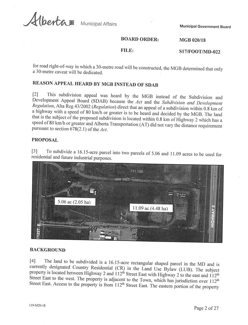
35 SUBDIVISION APPROVING AUTHORITY ITEM PLANNING AND DEVELOPMENT REPORT Acknowledgement of Receipt of MGB Order No.020/18 April 18, 2018 SUBDIVISION APPROVING AUTHORITY ACTION REQUESTED: Review and Acknowledgement of Attached Municipal Government Board decision LANDOWNER: Jeffrey Langford LEGAL DESCRIPTION: Plan , Block 7; SW W4M EXISTING PARCEL: acres PROPOSED PARCEL: 1 x 5.06+/- acres AGENT: CivicWorks Planning + Design EXISTING LAND USE: CR Country Residential DIVISION: #7 Rob Siewert FILE MANAGER: Drew Granson PROPOSAL: This application is for Subdivision to allow for the creation of one additional parcel of 5.06+/- acres leaving a balance of /- acres. BACKGROUND: April 5 th, 2017 Council gave first reading to Bylaw 25/2017 authorizing the Site Specific Amendment of the Country Residential District land use rules to allow for an Industrial Equipment Storage and Sales Business to operate within the central portion of Plan , Block 7; Ptn. SW W4M. Council is of the opinions that the proposed development will not unduly interfere with neighbouring land uses or materially interfere with/or affect the use, enjoyment, or value of neighbouring properties. Council is not supportive of allowing the RV Storage or the proposed subdivision. Prior to further consideration of Bylaw 25/2017, the applicant shall complete the following: Applicant to fully execute and comply with all requirements as outlined within a Development Agreement for the purposes of any required municipal improvements and engineering to the satisfaction of MD Council and Public Works; Applicant to submit a revised site plan demonstrating relocation of the Industrial Equipment Storage and Sales area to be fully located within the area proposed for RV storage. The revised site plan must be submitted for Councils review and approval; The applicant is to provide comprehensive Traffic Volume Projections, to the satisfaction of the Town of High River; Final Redesignation fees to be submitted; Submission of an application for development permit and the necessary fees. As there is no avenue of appeal at the amendment stage, the landowner has made application for subdivision for opportunity to appeal the decision before the Municipal Government Board. July 5 th, 2017 The Subdivision Approving Authority moved that the subdivision of one new /- acre lot from Plan , Block 7; Ptn. SW W4M be refused. The application for Amendment of the Country Residential Land Use District rules, within Section of the Land Use Bylaw No. 60/2014, to allow for the future subdivision of one additional parcel was refused by Council on April 5th, 2017; Section 662(a) of the Municipal Government Act states, a subdivision authority may require the owner of a parcel of land that is the subject of 35
36 a proposed subdivision to provide part of that parcel of land for the purpose of roads, public utilities or both. The Subdivision Authority is of the opinion that the lands proposed for future road dedication are not sufficient to support future road alignment and infrastructure requirements in the area; In consideration of Section 11.1: 2013 Flood Hazard Protection Overlay, Purpose and Intent states: The general purpose of this section is to provide for the safe and efficient use of lands within the floodway and flood fringe of all the rivers, streams, creeks and waterways as they are defined under the Alberta Environment s Flood Hazard Identification Program, as well as the areas impacted by June 2013 flood event within the Municipal District of Foothills No. 31. The Intent of this section is to discourage new development on lands subject to flooding and achieve the long term goal of maintaining and decreasing the overall density of development on lands that may be subject to flooding. The Subdivision Authority did not find sufficient merit in the proposal to consider additional development within lands that may be subject to flooding, and are of the opinion that development should be discouraged within potentially hazardous lands; Regarding criteria within Policies 3 and 9 of the Residential Section of the MDP2010, the Subdivision Authority is of the opinion that the application does not adequately address the intent of the Residential policies with respect to the suitability of the land for residential uses, the cumulative effects of the development, and is of the opinion that the proposed lands are subject development restrictions due to hazardous lands and flooding. In consideration of concerns provided from the Town of High River, the Subdivision Authority supports the Town of High River s position that a comprehensive approach to the planning of this area is preferred to an ad-hoc approach, and recommends that this subdivision be deferred until an Area Structure Plan has been developed and accepted by both Councils. In addition, the Subdivision Authority is of the opinion that the proposed subdivision does not align with the policies within Section 5.7 (FAA) Future Annexation Areas: of the Town of High River and MD of Foothills Intermunicipal Development Plan. September 20 th, 2017 Appeal against Subdivision Refusal was heard by the Municipal Government Board (MGB). April 4 th, 2018 The MGB issued a decision with regards to the appeal against the subdivision approving authority s decision to refuse the proposed subdivision. The MGB allowed the appeal and overturned the Subdivision Approving Authority s decision for refusal. For review of the complete Municipal Government Board decision, please refer to Board Order MGB 020/18, attached below. SUBDIVISION APPROVING AUTHORITY ACTION REQUESTED: The subdivision Approving Authority is respectfully requested to acknowledge receipt of Municipal Government Board Order No. MGB 020/18. ENCLOSURES: Location Map Submitted Site Plan & Submitted Lot Ortho MGB Order No. 020/18 36

37 IDP Area Town of High River Subject Parcel 112 th Street E. 37

38 SUBMITTED SITE PLAN SUBMITTED LOT ORTHO 38
39 39
40 40
41 41
42 42
43 43
44 44
45 45
46 46
47 47
48 48
49 49
50 50
51 51
52 52
53 53
54 54
55 55
56 56
57 57
58 58
59 59
60 60
61 61
62 62
63 63
64 64
65 65
66 66
67 SUBDIVISION APPROVING AUTHORITY ITEM PLANNING AND DEVELOPMENT REPORT Subdivision Time Extension Request April 18 th, 2018 LANDOWNERS: Sincerus (Hawks Springs) GP Ltd. LEGAL DESCRIPTIONS: 1. NE W5M 2. NE W5M 3. SE W5M EXISTING PARCELS: acres acres acres NUMBER OF PROPOSED NEW PARCELS: 14 Cluster Residential Sub District A parcels 1 Municipal Reserve 1 Public Utility lot 1 Environmental Protection District parcel 1 Balance parcel AGENT: DIVISION: #5 Councillor Alan Alger EXISTING LAND USE: 1. A Agricultural District 2. A Agricultural District 3. A Agricultural District FILE MANAGER: Julie McLean BACKGROUND May 24 th, 2017 Council granted a subdivision approval to create Phase 1 of the Springs at DeWinton Development to allow for 14 Cluster Residential Sub A District parcels, 1 Municipal Reserve, 1 Public Utility Lot, 1 Environmental Protection District parcel and 1 balance parcel. The approval motion from Council can be summarized as follows: That the subdivision of Phase 1 of the Springs at DeWinton development, which includes 14 x 0.81+/- to 1.99+/- acre Cluster Residential A District parcels, 1 x /- acre Municipal Reserve parcel, and 1 x 14.3+/- acre Public Utility Lot parcel leaving an Environmental Protection District balance parcel of ac in NE W5 and a balance in SE W5, as contemplated in the Springs of DeWinton Outline Plan be approved subject to the following conditions: 1. Subdivision to be effected by Plan of Survey, pursuant to Section 657 of the Municipal Government Act, or such other means satisfactory to the Registrar of the South Alberta Land Titles District; 2. Compliance with all requirements as set forth by Alberta Culture and Tourism with respect to Historical Resources Act approval; 3. Execution of an Easement and Access Right-of-Way Agreement, with the M.D. of Foothills as a party to the agreement, to be registered by right-of-way plan concurrently with the plan of survey, to the satisfaction of the Municipality. The purpose of the 67
68 easement is to provide temporary access to the proposed stormwater management and water treatment facilities to be located on the /- acre balance in SE W5 until such time that the road network contemplated for the Springs at DeWinton development can facilitate legal physical access; 4. Applicant is to fully comply with all of the requirements as outlined within the Municipal Development Agreement executed November 10, 2016 to the satisfaction of the Municipality for the purposes of: o Payment of all fees as outlined in the Development Agreement; o Construction of the following municipal improvements: Internal & external road construction including intersectional treatments (if applicable); Wastewater/sanitary sewer system; Water supply and treatment facilities; Landscaping, grading and stormwater management facilities; Utility infrastructure construction. 5. Completion of all pre-release conditions as noted in the executed Municipal Development Agreement(s) to the satisfaction of the Municipality. These conditions include: o Payment of the external road improvement fee of $8, (Eight Thousand Dollars) per new cluster residential unit within the subdivision phase; o Submission of all necessary Engineered drawings, cost estimates and engineering review fees for all required municipal and external improvements (this includes internal roads, external roads, intersectional treatments if applicable, water and wastewater/sanitary infrastructure, stormwater infrastructure, grading, landscaping and utility infrastructure) for review and approval by the Municipality; o Submission of all necessary Letters of Credit, in accordance with the Municipal Development Agreement, for all required municipal and/or external improvements; o Submission of Liability Insurance requirements as noted in the Municipal Development Agreement; o The Developer shall submit proof of all Licenses and Approvals of Alberta Environment and Parks pertaining to potable water supply, sanitary services and stormwater facilities to the satisfaction of the Municipality; o All utility easements and right of way agreements, licenses and installation requirements to be provided to the satisfaction of the Municipality, applicable external agencies and utility companies. 6. Executed Municipal Development Agreement(s) to be complied with and registered on the title of the lands subject to the Development Agreement concurrently with the plan of survey; 7. Execution of Acquisition of Land Agreement(s) along the east boundary of the property in order to protect the right-of-way needed for future access requirements along Meridian Street, to the satisfaction of the Municipality; 8. Stormwater Management Plan to be provided for the subject lands to the satisfaction of the Municipality which shall include how the recommendations from Section 7.0 of the Westhoff Engineering Resources Inc. Flood Hazard Identification Study (dated February 2014) will be addressed; 9. Compliance with all requirements as outlined by Alberta Environment & Sustainable Resource Development; 68
69 10. Submission of finalized Architectural Design Guidelines to the satisfaction of the Municipality; 11. Submission of revised Environmental Stewardship Plan that addresses the management and maintenance of stormwater facilities to be located on the Environmental Protection District parcel to the satisfaction of the Municipality; 12. Submission of finalized Utilities Ownership and Management Plan to the satisfaction of the Municipality and Alberta Environment; 13. Submission of Erosion and Sediment Control Plan for subject phase to the satisfaction of the Municipality; 14. Submission of Environmental Construction Operation Plan to the satisfaction of the Municipality Landowners are to pay all arrears of taxes on the existing parcel prior to finalization of the subdivision; 15. It is the applicant s responsibility to provide a Real Property Report or an as built drawing signed and sealed by an Alberta Land Surveyor, certifying the location of the adjacent municipal road(s) and that the site plan is surveyed according to municipal setback requirements; 16. Submission of final subdivision fees. COMPLETED CONDITIONS The applicants have completed condition #2: PROPOSAL Compliance with all requirements as set forth by Alberta Culture and Tourism with respect to Historical Resources Act approval; The applicants are requesting that Council provide a time extension on the subdivision approval in order to allow the landowner until May 24 th, 2019 to complete the required approval conditions as listed above. See attached letter from applicants. The time extension fee has been submitted. COUNCIL ACTION REQUESTED Council is respectfully requested to provide a decision on the time extension as requested by the applicants. Letter attached. ENCLOSURES Location Map Site Plan Phase One Tentative Plan of Subdivision - Phase One Letter from Applicant 69

70 LOCATION MAP Heritage Pointe SUBJECT PARCEL 70

71 SITE PLAN PHASE ONE PHASE 1 FUTURE PHASES 71
Pg. 3 *1. Birch NW W4M Development Permits 13D 083 and 15D 156 (Request for extension to complete conditions)
") MUNICIPAL DISTRICT OF FOOTHILLS NO. 31 January 10, 2018 Location: M.D. of Foothills Administration Office 309 Macleod Trail South High River COUNCIL AGENDA A. GENERAL MATTERS 1. Call Meeting to Order 2.
MUNICIPAL DISTRICT OF FOOTHILLS NO. 31 January 10, 2018 Location: M.D. of Foothills Administration Office 309 Macleod Trail South High River COUNCIL AGENDA A. GENERAL MATTERS 1. Call Meeting to Order 2.
The Council of the Municipal District of Foothills No. 31 met at the Foothills Administration Building, High River, Alberta, for a meeting on
 The Council of the Municipal District of Foothills No. 31 met at the Foothills Administration Building, High River, Alberta, for a meeting on September 13, 2017 at 9:00 a.m. Present were Mayor L. Spilak,
MUNICIPAL DISTRICT OF ROCKY VIEW NO. 44 ELBOW VALLEY WEST DIRECT CONTROL DISTRICT BYLAW C
 This document has been consolidated for convenience only. A current listing of any and all amendments can be obtained from the Municpal District Office Bylaw No. Date of Approval Amendment Type Bylaw C-6042-2005
Prt. NE W5. Prepared for: Municipal District of Foothills #31. Prepared by:
 Prt. NE 22-22-3-W5 Prepared for: Municipal District of Foothills #31 Prepared by: Bowwood Land Services Inc. R.R. 1, Dewinton, Alberta T0L 0X0 Tel: 403-995-2225 Fax: 403-938-4787 " OFFICIAL COPY " ADOPTED
Samantha Payne Pg. 25 1:30 pm *3. Annual Fee Bylaw Amendment Request for 2 nd & 3 rd Reading
 MUNICIPAL DISTRICT OF FOOTHILLS NO. 31 December 12, 2018 Location: M.D. of Foothills Administration Office 309 Macleod Trail South High River COUNCIL AGENDA A. GENERAL MATTERS 1. Call Meeting to Order
INDUSTRIAL/COMMERCIAL DEVELOPMENTS
 INDUSTRIAL/COMMERCIAL DEVELOPMENTS Box 69, 4912 50 Ave, Kitscoty, AB T0B 2P0 DEVELOPMENT PERMIT APPLICATION (PART A) INFORMATION AND CHECKLIST REQUIREMENTS A Development Permit Application will only be
RURAL GENERAL RG 1. PERMITTED USES DISCRETIONARY USES
 RURAL GENERAL RG PURPOSE: To protect the agricultural land base of the municipality while allowing nonagricultural developments which complement the area's economy. 1. PERMITTED USES DISCRETIONARY USES
A Guide to the Municipal Planning Process in Saskatchewan
 A Guide to the Municipal Planning Process in Saskatchewan A look at the municipal development permit and the subdivision approval process in Saskatchewan May 2008 Prepared By: Community Planning Branch
Corman Park - Saskatoon Planning District Official Community Plan
 1 Corman Park - Saskatoon Planning District Official Community Plan CONSOLIDATED: October, 2017 2 Table of Contents Bylaw Amendments... 3 Section 1: Foundations... 4 Section 2: Future Growth Sector Objectives
MUNICIPAL PLANNING COMMISSION AGENDA June 12, :30 AM
 Page MUNICIPAL PLANNING COMMISSION AGENDA June 12, 2018 9:30 AM 1.0 CALL TO ORDER 2.0 APPROVAL OF AGENDA 2.1 Additional Agenda Items 3.0 CONFIRMATION OF THE MINUTES 2-12 3.1 Minutes of the Municipal Planning
APPLICATION FOR DEVELOPMENT PERMIT General Information
 General Information COMPLETE THE ATTACHED APPLICATION FORM by printing clearly or filling out all of the required fields electronically. The application must be signed by the registered owner(s) of the
ARTICLE 7. SPECIFIC USE STANDARDS
 ARTICLE 7. SPECIFIC USE STANDARDS Section 7.1 Applicability The following standards apply to specified uses in all zoning districts in which such uses are allowed. Section 7.2 Accessory Apartments (A)
Telecommunications Development Permit Application Package
 Telecommunications Development Permit Application Package POLICY POL#308 Title: Policy Guidelines to Evaluate Commercial Communications Facilities Legal References: Radio Communication Act Municipal Government
5. That the Owner shall agree that all development Blocks shown within the Draft Plan will be connected to full municipal services.
 Conditions Relating to Draft Plan of Subdivision Approval East Fonthill 26T 01014 (Draft Plan dated December 1, 2013, and revised August 28, 2014), the Town of Pelham 1. This approval applies to the Draft
City of Grande Prairie Development Services Department
 City of Grande Prairie Development Services Department COUNTRYSIDE SOUTH OUTLINE PLAN Prepared by: GPEC Consulting Ltd. #202, 10712-100th Street Grande Prairie, AB Council Resolution of August 20, 2001
Village of Barons LAND USE BYLAW NO January Consolidated to Bylaw No. 710, October 2018
 Village of Barons LAND USE BYLAW NO. 677 January 2013 Consolidated to Bylaw No. 710, October 2018 Prepared by. January 2013 Village of Barons Land Use Bylaw No. 677 Amendments Bylaw No. Amendment Description
Bylaw No The Corman Park Saskatoon Planning District Official Community Plan Bylaw, 2010
 Bylaw No. 8844 The Corman Park Saskatoon Planning District Official Community Plan Bylaw, 2010 Codified to Bylaw No. 9446 May 23, 2017 BYLAW NO. 8844 The Corman Park Saskatoon Planning District Official
ACCESSORY DWELLING UNITS
 ACCESSORY DWELLING UNITS LAND USE BYLAW C-4841-97 ACCESSORY DWELLING UNIT (ADU): means a subordinate dwelling unit attached to, created within or detached from the principal dwelling, single detached,
Conceptual Scheme SE W4
 December 2012 1. PURPOSE 1.1. The purpose of a Conceptual Scheme (CS) is as follows: a) To provide a framework for the subsequent subdivision and/or development of land within the Country Residential Policy
COUNTY COUNCIL MEETING AGENDA August 4, 2009 (to follow MPC Meeting)
") COUNTY COUNCIL MEETING AGENDA August 4, 2009 (to follow MPC Meeting) Page 1.0 CALL TO ORDER 2.0 APPROVAL OF AGENDA 2.1 Additional Agenda Items 3.0 MINUTES 3-8 3.1 Minutes of the regular meeting of County
COUNTY COUNCIL MEETING AGENDA August 4, 2009 (to follow MPC Meeting) Page 1.0 CALL TO ORDER 2.0 APPROVAL OF AGENDA 2.1 Additional Agenda Items 3.0 MINUTES 3-8 3.1 Minutes of the regular meeting of County
Financial Impact Statement There are no immediate financial impacts associated with the adoption of this report.
 STAFF REPORT Planning and Development Department Subject: Application by RYC Property to rezone a portion of lands on John Murray Dr. and Megan Lynn Dr. from R2 to R3 and to enter into a Development Agreement
LAND USE BYLAW NO SEPTEMBER 2017
 LAND USE BYLAW NO. 397 17 SEPTEMBER 2017 Prepared by TABLE OF CONTENTS ADMINISTRATION GENERAL Section 1 Title... Administration 1 Section 2 Purpose... Administration 1 Section 3 Effective Date... Administration
CHAPTER XVIII SITE PLAN REVIEW
 CHAPTER XVIII SITE PLAN REVIEW Section 18.1 Section 18.2 Description and Purpose. The purpose of this chapter is to provide standards and procedures under which applicants would submit, and the Township
8.5.1 R1, Single Detached Residential District
 8.5.1 R1, Single Detached Residential District The purpose of this district is to provide for residential development in the form of single detached dwellings. Dwelling, Single Detached Home Business,
LAND USE AND ZONING OVERVIEW
 OVERVIEW OF PLANNING POLICIES LAND USE AND ZONING OVERVIEW The Minneapolis Plan for Sustainable Growth and Other Adopted Plans Community Planning and Economic Development Development Services Division
SUBDIVISION Application Information
 Application Information COMPLETE THE ATTACHED APPLICATION FORM by printing clearly or filling out all of the required fields electronically. The application must be signed by the registered owner(s) of
EXCERPTS FROM HALIFAX REGIONAL MUNICIPALITY CHARTER
 EXCERPTS FROM HALIFAX REGIONAL MUNICIPALITY CHARTER Municipal planning strategy 227 The Council may adopt a municipal planning strategy for all, or part, of the Municipality and there may be separate strategies
ARTICLE VI. SPECIAL EXCEPTION REGULATIONS
 ARTICLE VI. SPECIAL EXCEPTION REGULATIONS SECTION 601. GENERAL DESCRIPTION Special exceptions are deemed to be permitted uses in their respective districts, subject to the satisfaction of the requirements
New Cingular Wireless Telecommunication Tower at County Road 48, Milner Conditional Use Permit
 New Cingular Wireless Telecommunication Tower at 39415 County Road 48, Milner ACTIVITY #: Conditional Use Permit PP2012-023 HEARING DATES: Planning Commission (PC): August 16, 2012 at 6:00pm PETITIONER:
The Council of the Municipal District of Foothills No. 31 met at the Foothills Administration Building, High River, Alberta, for a meeting on October
 The Council of the Municipal District of Foothills No. 31 met at the Foothills Administration Building, High River, Alberta, for a meeting on October 11, 2017 at 9:00 a.m. Present were Mayor L. Spilak,
PROPOSED TEXT CHANGES TO LAND USE BYLAW - JULY 2016
 SECTION # BRIEF SUMMARY OF CHANGE PROPOSED CHANGE CURRENT WORDING AMENDMENTS TO SECTION 2.5 - DEFINITIONS UTILITY SERVES (Both Major and Minor) Remove the word infrastructure from the definition title
This is a conditional use permit request to establish a commercial wind energy conversion system.
 Public Works 600 Scott Boulevard South Hutchinson, Kansas 67505 620-694-2976 Road & Bridge Planning & Zoning Noxious Weed Utilities Date: March 28, 2019 To: From: Reno County Planning Commission Russ Ewy,
SPEAR S RANCH ON SALADO CREEK ARCHITECTURAL CONTROL COMMITTEE IMPROVEMENT GUIDELINES
 SPEAR S RANCH ON SALADO CREEK ARCHITECTURAL CONTROL COMMITTEE IMPROVEMENT GUIDELINES These GUIDELINES are a summary of the DECLARATION plus any additional and/or adjusted requirements ADOPTED by the ACC
MUNICIPAL DEVELOPMENT PLAN
 MUNICIPAL DEVELOPMENT PLAN Prepared by: The Council and Planning and Development Services Bylaw No. 1414-09 adopted August 12, 2009 Amending Bylaw - 1480-12 adopted June 12, 2013 Amending Bylaw 1529-14
Greenfield Development Requirements
 Greenfield Development Requirements Planning & Engineering Department City of Yorkton Saskatchewan 2014 Summary Greenfield Development refers to the development of raw land to a finished state as residential,
ARTICLE 14 PLANNED UNIT DEVELOPMENT (PUD) DISTRICT
 DISTRICT") ARTICLE 14 PLANNED UNIT DEVELOPMENT (PUD) DISTRICT Section 14.01 Intent. It is the intent of this Article to allow the use of the planned unit development (PUD) process, as authorized by the Michigan Zoning
ARTICLE 14 PLANNED UNIT DEVELOPMENT (PUD) DISTRICT Section 14.01 Intent. It is the intent of this Article to allow the use of the planned unit development (PUD) process, as authorized by the Michigan Zoning
DEVELOPMENT PERMIT APPLICATION INFORMATION PACKAGE
 PLANNING & DEVELOPMENT SERVICES 38106 Rge Rd 275, Red Deer County, AB T4S 2L9 Phone: (403)350-2170 Fax: (403)346-9840 www.rdcounty.ca DEVELOPMENT PERMIT APPLICATION INFORMATION PACKAGE INFORMATION AND
Town of Beaumont Municipal Planning Commission Meeting Thursday, July at 11:00 a.m. Beaumont Town Office Council Chambers ~ AGENDA ~
 Town of Beaumont Municipal Planning Commission Meeting Thursday, July 20 2017 at 11:00 a.m. Beaumont Town Office Council Chambers FILE: 0562-M01 ~ AGENDA ~ 1. CALL TO ORDER 2. MODIFICATION TO THE AGENDA
LAND USE BYLAW NO. 747
 TOWN OF PICTURE BUTTE LAND USE BYLAW NO. 747 Prepared by the OLDMAN RIVER INTERMUNICIPAL SERVICE AGENCY June 1998 Amended to Bylaw No. 792-06 TABLE OF CONTENTS TITLE... 1 DATE OF COMMENCEMENT... 1 REPEAL
UPPER MOUNT BETHEL TOWNSHIP NORTHAMPTON COUNTY, PENNSYLVANIA
 UPPER MOUNT BETHEL TOWNSHIP NORTHAMPTON COUNTY, PENNSYLVANIA JOINDER DEED / LOT CONSOLIDATION TOWNSHIP REVIEW PROCESS When accepting proposed Joinder Deeds / Lot Consolidations, review the Joinder Deed
Residential Project Convenience Facilities
 Standards for Specific Land Uses 35.42.220 E. Findings. The review authority shall approve a Land Use Permit in compliance with Subsection 35.82.110.E (Findings required for approval) or a Conditional
MINUTES OF THE MUNICIPAL PLANNING COMMISSION Tuesday, May 5, 2015 Red Deer County Council Chambers, Red Deer County Centre
 MINUTES OF THE MUNICIPAL PLANNING COMMISSION Tuesday, May 5, 2015 Red Deer County Council Chambers, Red Deer County Centre Present: Absent: Chairman Councillor P.J.R. Massier, Mayor J.J. Wood, Councillors
MUNICIPAL PLANNING COMMISSION AGENDA July 19, :30 AM
 Page MUNICIPAL PLANNING COMMISSION AGENDA July 19, 2016 9:30 AM 1.0 CALL TO ORDER 2.0 APPROVAL OF AGENDA 2.1 Additional Agenda Items 3.0 CONFIRMATION OF THE MINUTES 2-9 3.1 Minutes of the Municipal Planning
SUPPLEMENTARY REQUIREMENTS SPECIFIED PENALTIES FOR OFFENCES RIPARIAN SETBACK MATRIX MODEL RURAL APPROACH STANDARDS POLICY COMMUNITY STANDARDS BYLAW
 APPENDICES APPENDIX A APPENDIX B APPENDIX C APPENDIX D APPENDIX E APPENDIX F APPENDIX G APPENDIX H APPENDIX I APPENDIX J APPENDIX K SUPPLEMENTARY REQUIREMENTS TELECOMMUNICATION TOWERS CONFINED FEEDING
Attached is a Clinton Township Zoning Permit Application and requirements for issuance of a permit.
 To Whom It May Concern: Attached is a Clinton Township Zoning Permit Application and requirements for issuance of a permit. The fee for the permit application is $75.00, which shall be made payable to
O-I (Office-Institutional) and AG-1(Agricultural)
 and AG-1(Agricultural)") PROPERTY INFORMATION ADDRESS 3503 and 3505 Bethany Bend DISTRICT, LAND LOTS 2/1 973 and 974 OVERLAY DISTRICT State Route 9 PETITION NUMBERS EXISTING ZONING O-I (Office-Institutional) and AG-1(Agricultural)
PROPERTY INFORMATION ADDRESS 3503 and 3505 Bethany Bend DISTRICT, LAND LOTS 2/1 973 and 974 OVERLAY DISTRICT State Route 9 PETITION NUMBERS EXISTING ZONING O-I (Office-Institutional) and AG-1(Agricultural)
LAND USE AMENDMENT SPRINGBANK HILL (WARD 6) ELMONT DRIVE SW AND 69 STREET SW BYLAW 114D2017
 ELMONT DRIVE SW AND 69 STREET SW BYLAW 114D2017") Page 1 of 8 EXECUTIVE SUMMARY This land use amendment application proposes to redesignate and subdivide 1.15 hectares of land located within the southwest community of East Springbank to accommodate 17
Page 1 of 8 EXECUTIVE SUMMARY This land use amendment application proposes to redesignate and subdivide 1.15 hectares of land located within the southwest community of East Springbank to accommodate 17
STAFF REPORT. Permit Number: Porter. Kitsap County Board of Commissioners; Kitsap County Planning Commission
 STAFF REPORT Permit Number: 15 00461 Porter DATE: November 9, 2015 TO: FROM: Kitsap County Board of Commissioners; Kitsap County Planning Commission Katrina Knutson, AICP, Senior Planner, DCD and Jeff
PLANNING RATIONALE REPORT
 PLANNING RATIONALE REPORT Zoning By-law Amendment Application 2920 Danbury Way Prepared for: Bravar Custom Builders Inc. and Village View Estates Ltd. by: 6393 Roslyn Street Ottawa (Orleans), Ontario K1C
SUBDIVISION AND DEVELOPMENT APPEAL BOARD PARKLAND COUNTY. DATE: May 29, 2018 FILE NO.: 18-S-003
 SUBDIVISION AND DEVELOPMENT APPEAL BOARD PARKLAND COUNTY Legislative Services Parkland County Centre 53109A HWY 779 Parkland County, AB T7Z 1R1 Telephone: (780) 968-3234 Fax: (780) 968-8413 DATE: May 29,
PLANNED UNIT DEVELOPMENT & SUBDIVISION STAFF REPORT Date: November 17, 2016
 PLANNED UNIT DEVELOPMENT & SUBDIVISION STAFF REPORT Date: November 17, 2016 DEVELOPMENT NAME SUBDIVISION NAME LOCATION Autonation Ford of Mobile Autonation Ford of Mobile Subdivision 901, 909, and 925
Moved that Council support use of Provincial Highways within the M.D. of
 The Council of the Municipal District of Foothills No. 31 met at the Foothills Administration Building, High River, Alberta, for a meeting on September 6, 2017 at 9:00 a.m. Present were Mayor L. Spilak,
ADMINISTRATIVE HEARING STAFF REPORT
 ADMINISTRATIVE HEARING STAFF REPORT Providence Place Apartments Utility Box No. 2 Conditional Use Petition PLNPCM2011-00426 309 East 100 South September 22, 2011 Planning and Zoning Division Department
Title 17 MOBILE HOMES AND RECREATIONAL VEHICLES
 17.04 General Provisions Title 17 MOBILE HOMES AND RECREATIONAL VEHICLES 17.04.010 General provisions 17.04.020 Application 17.04.030 Interpretation 17.04.040 Mobile homes and recreational vehicles--location
ARTICLE XI CONDITIONAL USE PERMITS
 ARTICLE XI CONDITIONAL USE PERMITS 11.1 Purpose. The City of Hailey recognizes that certain uses possess unique and special characteristics with respect to their location, design, size, method of operation,
PROPOSED AMENDMENTS TO THE DERBY ZONING REGULATIONS AUGUST 12, 2008
 ARTICLE II Definitions and word usage 195-7. Definitions and word usage. Modify the following: HOUSING FOR THE ELDERLY OLDER PERSONS Housing in accordance with and as defined in the United States Fair
Legal Description Part of the Western Half of the Eastern Half of the Northwest Quarter of Section 30, Le Ray Township
 Owner and Applicant s 20448 State Highway 83 Mankato, MN 56001 Request and Location Request for review and approval of a Conditional Use Permit to allow an Elder Care Residential Unit to be constructed
THE CITY OF RAYMORE, MISSOURI Single-Family Residential Zoning Districts
 THE CITY OF RAYMORE, MISSOURI Single-Family Residential Zoning Districts REGULATIONS COMMON TO ALL DISTRICTS: Uses permitted in each district include detached single-family dwellings, manufactured homes
DRAFT BUTTE COUNTY SHORT TERM RENTAL ORDINANCE (August 29, 2018)
") (August 29, 2018) A. Purpose. This section establishes a definition, permit process, rental term, site requirements, standards, and permit revocation requirements for short term rentals to ensure that,
(August 29, 2018) A. Purpose. This section establishes a definition, permit process, rental term, site requirements, standards, and permit revocation requirements for short term rentals to ensure that,
ARTICLE (SM) SURFACE MINING ZONE. 2. To allow the development and use of mineral and aggregate resources;
 SURFACE MINING ZONE. 2. To allow the development and use of mineral and aggregate resources;") ARTICLE 15.00 (SM) SURFACE MINING ZONE 15.01 PURPOSE The purposes of the Surface Mining Zone are: 1. To implement the policies of the Comprehensive Plan; 2. To allow the development and use of mineral
ARTICLE 15.00 (SM) SURFACE MINING ZONE 15.01 PURPOSE The purposes of the Surface Mining Zone are: 1. To implement the policies of the Comprehensive Plan; 2. To allow the development and use of mineral
ARTICLE 24 SITE PLAN REVIEW
 ARTICLE 24 SITE PLAN REVIEW 24.1 PURPOSE: The intent of these Ordinance provisions is to provide for consultation and cooperation between the land developer and the Township Planning Commission in order
MUNICIPAL PLANNING COMMISSION AGENDA June 20, :30 AM
 Page MUNICIPAL PLANNING COMMISSION AGENDA June 20, 2017 9:30 AM 1.0 CALL TO ORDER 2.0 APPROVAL OF AGENDA 2.1 Additional Agenda Items 3.0 CONFIRMATION OF THE MINUTES 2-4 3.1 Minutes of the Municipal Planning
Town of Truckee. Contents. Article I - Development Code Enactment and Applicability. Chapter Purpose and Effect of Development Code...
 Town of Truckee TITLE 18 - DEVELOPMENT CODE Article I - Development Code Enactment and Applicability Chapter 18.01 - Purpose and Effect of Development Code... I-3 18.01.010 - Title... I-3 18.01.020 - Purposes
Planning & Development. Background. Subject Properties
 Planning & Development APPLICATION BRIEFING Prepared For: Planning Advisory Committee Submitted by: Jason Fox, Director of Planning & Development Date: Subject: Application by Meech Holdings Limited to
19.12 CLUSTER RESIDENTIAL DISTRICT
 Chapter 19.12 CLUSTER RESIDENTIAL DISTRICT (Adopted 12/22/2003; Ordinance #0061970). Amended 7/3/17, Ordinance #079100. Section 19.12.010 - Declaration of Intent. The Cluster Residential District provides
Potential Conditions of Approval for Marion County Land Use Decisions
 Potential Conditions of Approval for Marion County Land Use Decisions Planning Division 5155 Silverton Rd. NE Salem OR 97305 Ph. (503) 588-5038; fax (503) 589-3284 http://www.co.marion.or.us/pw/planning
APPLICATION PROCESSING STEPS STEP 1 CHECK WITH STAFF
 APPLICATION PROCESSING STEPS STEP 1 CHECK WITH STAFF - Development Services Staff will explain the requirements and procedures to you. However, before filing an application with the Community Development
RE: 6. GILL/GREEN COMPREHENSIVE PLAN AMENDMENT, REZONING AND PRELIMINARY PLAT
 commission memo DATE: Thursday - August 9, 2018 TO: Marion Planning & Zoning Commission FROM: David N. Hockett, AICP Principal Planner RE: 6. GILL/GREEN COMPREHENSIVE PLAN AMENDMENT, REZONING AND PRELIMINARY
Wapiti Ridge Estates Area Structure Plan SE W5M. December Prepared For:
 SE 13-20-1 W5M December 2000 Prepared For: 393494 Alberta Limited, and The Municipal District of Foothills No. 31 Prepared By: Kristi Beunder Professional Planning Services Calgary, Alberta Ph: 201-3309
COMMUNITY PLAN PLANNING & URBAN DESIGN
 WHALE COVE COMMUNITY PLAN PLANNING & URBAN DESIGN WHALE COVE COMMUNITY PLAN Prepared for: Department of Community and Government Services Government of Nunavut Rankin Inlet, Nunavut Prepared by: FoTenn
PLANNING COMMISSION REPORT Regular Agenda Public Hearing Item
 PC Staff Report 11/12/12 Item No. 2B- 1 PLANNING COMMISSION REPORT Regular Agenda Public Hearing Item ITEM NO. 2B: A TO GPI; 110 ACRES; E OF K-10 & N OF W 6 TH ST (MKM) : Consider a request to rezone approximately
1:30 pm 2. AbbeyField House Society of High River Representatives Request for Funding
 MUNICIPAL DISTRICT OF FOOTHILLS NO. 31 November 7, 2018 Location: M.D. of Foothills Administration Office 309 Macleod Trail South High River COUNCIL AGENDA A. GENERAL MATTERS 1. Call Meeting to Order 2.
Special Land Use. SLU Application & Review Standards
 review and approval is needed for certain uses of property that have the potential to impact adjacent properties and the neighborhood. The application and review procedure is intended to ensure that the
Request Conditional Use Permits (Craft Brewery & Open-Air Market) Staff Recommendation Approval. Staff Planner Bill Landfair
 Staff Recommendation Approval. Staff Planner Bill Landfair") Applicant Property Owner Weathersby Properties, LLC Public Hearing March 13, 2019 (Deferred February 13, 2019) City Council Election District Bayside Agenda Item D2 Request Conditional Use Permits (Craft
Applicant Property Owner Weathersby Properties, LLC Public Hearing March 13, 2019 (Deferred February 13, 2019) City Council Election District Bayside Agenda Item D2 Request Conditional Use Permits (Craft
PART 6 GENERAL REGULATIONS
 PART 6 GENERAL REGULATIONS 6.1 GENERAL PROVISIONS (1) The general development regulations of this Section prevail in all districts. Where there appears to be a conflict with the regulations in other Sections,
Chapter 100 Planned Unit Development in Corvallis Urban Fringe
 100.100 Scope and Purpose. Chapter 100 Planned Unit Development in Corvallis Urban Fringe (1) All applications for land divisions in the Urban Residential (UR) and Flood Plain Agriculture (FPA) zones within
City of Escondido Zoning Administrator
 City of Escondido Zoning Administrator AGENDA AND RECORD OF ACTIONS 201 North Broadway City Hall Mitchell Room October 25, 2018 3:00 p.m. A. Call to Order: Zoning Administrator: Mike Strong Staff Present:
What is a Conditional Use? When is a Conditional Use Necessary? Who decides if I will get a Conditional Use Permit
 What is a Conditional Use? A conditional use is a land use or development that would not be appropriate generally but may be allowed with appropriate controls upon a finding that certain conditions as
SECTION CLASSIFICATION OF ZONES For the purpose of this Code the following primary land use zoning districts are hereby established:
 ARTICLE 4 ZONING DISTRICTS SECTION 4.010 CLASSIFICATION OF ZONES For the purpose of this Code the following primary land use zoning districts are hereby established: Primary Zones Abbreviated Designation
LAND OWNER OF SITE ADDRESS PHONE NUMBER FAX NUMBER. APPLICANT (if other than owner) ADDRESS PHONE NUMBER FAX NUMBER
 ADDRESS PHONE NUMBER FAX NUMBER") TELECOMMUNICATION TOWER CONDITIONAL USE PERMIT APPLICATION FOR WALWORTH COUNTY - $1025 The undersigned hereby applies to the Walworth County Zoning Agency (Walworth County Land Use and Resource Management
TELECOMMUNICATION TOWER CONDITIONAL USE PERMIT APPLICATION FOR WALWORTH COUNTY - $1025 The undersigned hereby applies to the Walworth County Zoning Agency (Walworth County Land Use and Resource Management
Draft Model Access Management Overlay Ordinance
 Draft Model Access Management Overlay Ordinance This model was developed using the City of Hutchinson and the Trunk Highway 7 corridor. The basic provisions of this model may be adopted by any jurisdiction
MINUTES OF THE MUNICIPAL PLANNING COMMISSION Tuesday, May 18, 2010 Red Deer County Council Chambers, Red Deer County Centre
 MINUTES OF THE MUNICIPAL PLANNING COMMISSION Tuesday, May 18, 2010 Red Deer County Council Chambers, Red Deer County Centre Present: Chairman Councillor G.W. Gehrke, Mayor E.R. Kinsella, Councillors P.T.
2 Adoption of Agenda and Emergent Issues. 3 Adoption of Minutes 2-10 a) Minutes of the Municipal Planning Commission meeting on May 6, 2015
 Minutes of the Municipal Planning Commission meeting on May 6, 2015") Page... 1 Call to Order VULCAN COUNTY Municipal Planning Commission AGENDA Wednesday, May 20, 2015 9:00 AM Vulcan County Council Chambers Administration Building 102 Centre Street, Vulcan, Alberta 2 Adoption
Page... 1 Call to Order VULCAN COUNTY Municipal Planning Commission AGENDA Wednesday, May 20, 2015 9:00 AM Vulcan County Council Chambers Administration Building 102 Centre Street, Vulcan, Alberta 2 Adoption
ADUs and You! Common types of ADUs include mother-in-law suite, garage apartments and finished basements.
 ADUs and You! Accessory Dwelling Units Town of Lyons Accessory Dwelling Units (ADUs) are a form of housing that can be an important tool for diversifying and increasing the local housing stock. Lyons lost
MINUTES DIDSBURY INTERMUNICIPAL PLANNING COMMISSION Mountain View County
 MINUTES DIDSBURY INTERMUNICIPAL PLANNING COMMISSION Mountain View County Minutes of the Didsbury Intermunicipal Planning Commission held on July 17, 2015, in the Council Chamber, 1408 Twp Rd. 320, Didsbury,
ARTICLE 2 ZONING DISTRICTS AND MAPS
 ARTICLE 2 ZONING DISTRICTS AND MAPS SECTION 2.100 PURPOSE OF DISTRICTS Section 2.101. For the purpose of this Ordinance, Billings Township is hereby divided into districts as follows: DISTRICT NAME SYMBOL
Paul D. Ralph, BES, RPP, MCIP, Commissioner, Development Services Department
 Public Report To: From: Report Number: Development Services Committee Paul D. Ralph, BES, RPP, MCIP, Commissioner, Development Services Department DS-16-50 Date of Report: April 14, 2016 Date of Meeting:
PLANNED UNIT DEVELOPMENTS
 PLANNED UNIT DEVELOPMENTS SECTION 9.01 DESCRIPTION AND PURPOSE. A. The purpose of a planned unit development (PUD) is to permit greater flexibility in development than is generally possible under standard
Application for Short-Term Rental (STR) Permit
 Permit") Application for Short-Term Rental (STR) Permit To: Hood River County Community Development 601 State Street Hood River, OR 97031 Date Received: Zoning: Conditional Use Permit: Yes No File No: Filing Fee:
Application for Short-Term Rental (STR) Permit To: Hood River County Community Development 601 State Street Hood River, OR 97031 Date Received: Zoning: Conditional Use Permit: Yes No File No: Filing Fee:
ARTICLE Encourage well planned, efficient development.
 ARTICLE 14.00 PD PLANNED SECTIONS: 14.01 Intent 14.02 Procedure 14.03 Initial Development Plan 14.04 Final Development Plan 14.05 Amendments 14.06 Planned Development Districts PD-1 Willow Run PD PD-2
Subdivision - Application
 Planning and Development Services, 2001 Sherwood Drive, Sherwood Park, AB T8A 3W7 Phone 780-464-8080 Fax 780-464-8109 Email: Landuse&policyplanning@strathcona.ca (Page 1 of 5) This form is to be completed
ARTICLE III ZONING DISTRICTS AND GENERAL REGULATIONS
 ARTICLE III ZONING DISTRICTS AND GENERAL REGULATIONS 3.1 Districts. The City of Wheaton, Illinois, is hereby divided into the following zoning districts. The following are general descriptions, but not
HAVERHILL BUSINESS PARK PROTECTIVE COVENANTS (Revised 8/3/09) Purpose
 Purpose") HAVERHILL BUSINESS PARK PROTECTIVE COVENANTS (Revised 8/3/09) Purpose The purpose of these Protective Covenants is to promote the industrial development of the Town of Haverhill so as to result in increased
HAVERHILL BUSINESS PARK PROTECTIVE COVENANTS (Revised 8/3/09) Purpose The purpose of these Protective Covenants is to promote the industrial development of the Town of Haverhill so as to result in increased
PROTECTIVE COVENANTS DEED RESTRICTIONS SPENCER BUSINESS/INDUSTRIAL PARK August 11, 1999 Amended, March 3, 2014
 PROTECTIVE COVENANTS DEED RESTRICTIONS SPENCER BUSINESS/INDUSTRIAL PARK August 11, 1999 Amended, March 3, 2014 1. GENERAL PURPOSES and CONDITIONS The real property conveyed hereby, being part of the Spencer
SUBDIVISION AND DEVELOPMENT APPEAL BOARD AGENDA
 SUBDIVISION AND DEVELOPMENT APPEAL BOARD AGENDA Thursday, 9:00 A.M. May 17, 2018 Hearing Room No. 3 Churchill Building, 10019-103 Avenue NW, Edmonton, AB Hearing Date: Thursday, May 17, 2018 2 SUBDIVISION
APPLICATION PROCESSING. CHECK WITH STAFF - Development Services Staff will explain the requirements and procedures to you.
 PLANNED DEVELOPMENT ZONE 1810 E. HAZELTON AVENUE, STOCKTON CA 95205 BUSINESS PHONE: (209) 468-3121 Business Hours: 8:00 a.m. to 5:00 p.m. (Monday through Friday) STEP 1 STEP 2 FEE FORM DEED SERVICES APPLICATION
(b) The location of principal and accessory buildings on the lot and the relationship of each structure to the other.
 The location of principal and accessory buildings on the lot and the relationship of each structure to the other.") ARTICLE XIX SITE PLAN Sec. 20-1900 Site Plan Review Procedure - Intent The site plan review procedures are instituted to provide an opportunity for the Township Planning Commission to review the proposed
ARTICLE XIX SITE PLAN Sec. 20-1900 Site Plan Review Procedure - Intent The site plan review procedures are instituted to provide an opportunity for the Township Planning Commission to review the proposed
City of Peachtree City. Annexation Review Process
 City of Peachtree City Annexation Review Process Page 1 Annexation Review Process Step One: Initial annexation information The following information is to be completed by the property owner and/ or their
SECTION B - GUIDELINES
 SECTION B - GUIDELINES APPLICATION KIT FOR SUBDIVISION RESOURCE CONSENT UNDER SECTION 88 OF THE RESOURCE MANAGEMENT ACT 1991 CONTENTS: PLEASE READ AND COMPLETE 1. Making an Application for a Subdivision
Article 7: Residential Land Use and Development Requirements
 Article 7: Residential Land Use and Section 701: Statement of Intent (A) (B) (C) The intent of Article 7 is to develop certain land use and development requirements for the residential uses within Cumru