Pg. 3 *1. Birch NW W4M Development Permits 13D 083 and 15D 156 (Request for extension to complete conditions)
|
|
|
- Marvin Chambers
- 6 years ago
- Views:
Transcription
1 MUNICIPAL DISTRICT OF FOOTHILLS NO. 31 January 10, 2018 Location: M.D. of Foothills Administration Office 309 Macleod Trail South High River COUNCIL AGENDA A. GENERAL MATTERS 1. Call Meeting to Order 2. Approval of the Agenda as Distributed 3. Consideration of Additions to the Agenda 4. Minutes December 13, Accounts January 10, 2018 B. PUBLIC WORKS/ENGINEERING C. PUBLIC HEARINGS & MEETINGS D. MISCELLANEOUS PLANNING ITEMS Pg. 3 *1. Birch NW W4M Development Permits 13D 083 and 15D 156 (Request for extension to complete conditions) Pg. 12 *2. Spruce Meadows Ltd. N/SE W5M Development Permit 17D 259 (Movies at the Meadows) Pg. 23 *3. Heritage Pointe Crossing Inc. S W4M Development Permit 17D 263 (Preschool and daycare facility) Pg. 35 *4. Waldner NW W5M Bylaw 49/2017 (2 nd and 3 rd reading) Pg. 39 *5. Sanja Holdings SE W5M Bylaw 88/2017 (2 nd and 3 rd reading) Pg. 43 *6. Foothills Land Trust NW W4M Conservation Easement Pg. 50 *7. Bayly NE W5M Bylaw 40/2017 (2 nd and 3 rd reading) Pg. 56 *8. Tierens and Verlinden NW W5M Bylaw 84/2017 (2 nd and 3 rd reading) Pg. 62 *9. Western Sky Land Trust Society SW/NW W5M Conservation Easement E. SUBDIVISION APPROVING AUTHORITY ITEMS Pg. 69 *1. Sanja Holdings SE W5M Request for Subdivision Pg. 75 *2. Tierens and Verlinden NW W5M Request for Subdivision
2 F. MISCELLANEOUS MUNICIPAL ITEMS G. TABLED ITEMS H. NEW BUSINESS 1. Committee Reports I. OTHER MATTERS 1. Adjourn 2. Next Meeting January 17, 2017 at 9:00 am 3. January Accounts Review Councillors: J. Parker, A. Alger and D. Miller
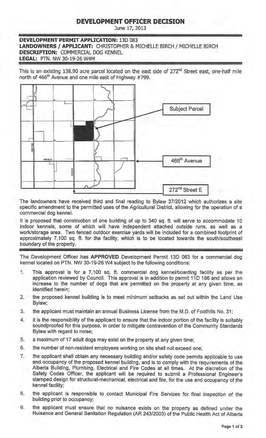
3 MISCELLANEOUS PLANNING ITEM DEVELOPMENT PERMIT REQUEST DIRECT CONTROL DISTRICT #26 January 10, 2018 LANDOWNER: Christopher & Michelle Birch LEGAL DESCRIPTION: NW W4M EXISTING PARCELS: acres NUMBER OF PROPOSED NEW PARCELS: N/A AGENT: N/A DIVISION: #1 Rob Siewert EXISTING LAND USE: Direct Control District #26 FILE MANAGER: Brenda Bartnik REQUEST TO COUNCIL: This is a request to Council with respect to Development Permit 13D 083 and 15D 156. As Council is the development authority for Direct Control District lands; unless having authorized a person or persons to carry out such duties, they shall consider and decide on requests regarding Development Permits pertaining to lands zoned under a Direct Control District. LOCATION: The subject property is located on the east side of 272 nd Street east, one-half mile north of 466 th Avenue and one mile east of Highway #799. POLICY AREA: This property is not guided by an existing Area Structure Plan, Outline Plan or Area Redevelopment Plan. The terms of the MDP 3010, the Growth Management Strategy and the Land Use Bylaw, apply. BACKGROUND: Development Permit 15D 156 Expansion to Existing Commercial Dog Kennel July 21, 2015 Council approved an application to: - allow up to a maximum of 40 dogs on the subject lands at any given time. Status: the following condition of permit remains unfulfilled. A request for a time extension to the permit has been received and is included within this report. - All dog facilities shall be visually screened by fences and landscaping around the perimeter in order to provide visual screening from existing dwellings on adjoining lots, as proposed, and accepted by Council. Redesignation Application Direct Control District #26 June 3, 2015 Council provided three readings, authorizing the redesignation of the southernmost 100 meters in perpendicular width throughout located along the south boundary, from Agricultural District to Direct Control District #26 to allow a Commercial Dog kennel as a discretionary use. Status: Complete Page 3
4 Development Permit 13D 083 Commercial Dog Kennel June 17, 2013, the Development Officer approved an application to: - allow for a commercial dog kennel/boarding facility with up to a maximum of 17 dogs at any given time on the Agricultural lands, as a permitted use. Status: the following condition of permit remains unfulfilled. A request for a time extension to the permit has been received and is included within this report. - A screening plan, consistent with the application to Council shall be provided to the development office for review and acknowledgement prior to installation. The facility shall be fenced and landscaped around the perimeter in order to provide visual screening from adjacent lands. Redesignation Application Site Specific Amendment Commercial Dog Kennel May 22, 2013 Council provided final reading, authorizing a Site Specific Amendment to the Agricultural Land Use District to allow a Commercial Dog Kennel as a permitted use. Status: Complete Development Permit 11D 186 Minor Home Occupation Mobile Dog Grooming November 30, 2011, the Development Officer approved an application to: - allow for the operation of a dog grooming service that included transportation of animals by the owner and a maximum of 3 dogs to be located on the parcel at any given time. Status: Complete REQUEST: As per the included letter of request, the landowner is asking for an extension to the time to complete the conditions of Development Permits 13D 083 and 15D 156, in order to allow for time to plant new shrubs around the perimeter of the kennel facilities. OPTIONS FOR CONSIDERATION: Following are three (2) possible options for Council s consideration: OPTION #1: APPROVAL Council may choose to grant approval for the request and allow for a time extension on development permits 13D 083 and 15D 156 to provide the applicant with additional time to satisfy all conditions of the permits. It is requested that Council identify a date by which the conditions of permit are to be fulfilled. OPTION #3: REFUSAL Council may choose to refuse the request for a time extension and provide additional direction with respect as to the preferred action(s) to take in order to bring the land into compliance with the Land Use Bylaw. ENCLOSURES: LOCATION MAPS SITE PLAN (as per most recent application) DEVELOPMENT DECISIONS LETTER OF REQUEST Page 4

5 Page 5 LOCATION MAPS
6 Page 6 SITE PLAN

7 Page 7 DEVELOPMENT DECISIONS
8 Page 8
9 Page 9
10 Page 10
11 Page 11 LETTER OF REQUEST
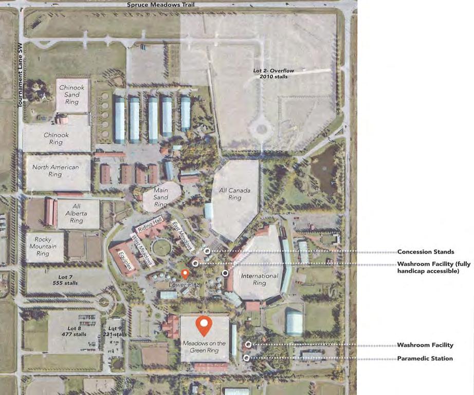
12 MISCELLANEOUS PLANNING ITEM APPLICATION FOR DEVELOPMENT PERMIT 17D 259 DIRECT CONTROL DISTRICT #1 January 10 th, 2018 LANDOWNER: Spruce Meadows Ltd. LEGAL DESCRIPTION: Plan , Block 2, Lot 1 N/SE W5M EXISTING PARCELS: acres NUMBER OF PROPOSED NEW PARCELS: N/A APPLICANT: CivicWorks Planning + Design DIVISION: #5 Alan Alger EXISTING LAND USE: Direct Control District #1 FILE MANAGER: Brenda Bartnik PROPOSAL: Request to allow for for an on-going seasonal (July through August) event, Movies at the Meadows. LOCATION: The subject property is located on the northern boundary of the Municipality on the southwest corner of the intersection of Spruce Meadows Trail SW (Highway 22x) and Spruce Meadows Way SW, immediately adjacent to the City of Calgary municipal boundaries. POLICY AREA: The land is located within the boundaries of the Spruce Meadows Area Structure Plan, Part A; and the Interface Area of the M.D. of Foothills and The City of Calgary Intermunicipal Development Plan, as well as the Central District under the Growth Management Plan. Land use is guided by the Municipal Development Plan 2010 and governed by the Land Use Bylaw 60/2014. BACKGROUND: The Spruce Meadows Area Structure Plan, Part A was adopted in The Area Structure Plan contemplates facilities rentals and event hosting, however the annual event proposed within this application is in addition to those events that had previously been acknowledged under any approval(s). The most recent land use approval for the facility was issued under Development Permit 13D 158, which allowed for the assembly of Canada House on the property. The development permit remains open, awaiting fulfillment of conditions of the permit relating to submission of a Professional Engineers review and stamped design. SITE CONSIDERATIONS: Access Location of the proposed event does not appear to affect existing access to facility lands. Land Features Will be retained as previously existed. Page 12
13 Improvements The proposed event will be supported by existing water and treatment facilities, parking, and water closets. PROPOSAL: The application requests approval for an annually occurring seasonal (July through August) event. It is being asked that Council consider the issuance of a development permit in such a manner that would allow for the event to be held on an ongoing basis without the requirement of having to obtain land use approval and a Special Event Permit each year. Movies at the Meadows is an outdoor movie event that is conducted throughout the months of July and August. Paying guests are invited to bring their own chair, blanket and the family and watch a movie under the stars on the Spruce Meadows Green Ring. Ticket purchase either in advance online, or at the door, is required. - 6 outdoor movies are to be held during the months of July and August (last two weeks in July and four weeks in August). - Attendance ranges from 800 3,000 people. - Free parking is accommodated in existing lots 7, 8 and 9, accessed via Tournament Lane. Overflow parking, accessed from Spruce Meadows Way, is available if necessary. As people arrive at varying times pending their desire to enjoy pre-movie entertainment, the lots are not staffed by an attendant(s) for these events. - The event is weather permitting. It is possible to relocate the event indoors into the existing Equi-Plex facility should the weather not cooperate. - Events that occurred during the summer of 2017 were conducted on Wednesday evenings, with doors opening at 7:30 PM. Movies are to start at sundown (+/- 9:30 PM), and activities cease at approximately 11:30 PM. It is anticipated that movies will continue to be held on a week night, but the actual day may be subject to change each year. - Pathways and stairways in the vicinity of Meadows on the Green are lit and beacons placed to illuminate any dark areas. Parking lots have temporary and portable mast lighting to illuminate the parking lots until they are emptied. - Family friendly entertainment is available on the Lower Plaza before the movie starts. Activities may include: bouncy castles, life-size chess, mini-putt, the parking and display of fire trucks, concession with popcorn and candy, lite music offering in the gazebo (one amplifier, or no amplification pending the instruments being used). - The Lower Plaza washroom facility is open during Movies at the Meadows, and an alcohol concession is offered, however no other Spruce Meadows facilities are open in conjunction with the events. - Privately contracted site security and paramedics are on site and Spruce Meadows follows their established emergency response protocol. Page 13
14 POLICY / PLANNING CONSIDERATIONS: MUNICIPAL DEVELOPMENT PLAN 2010 (MDP): RECREATION Commercial Recreational Developments Businesses providing recreational opportunities for a fee to the public, or to their private members, are commercial recreational developments. Some examples in the MD include golf courses, equestrian facilities, paint ball facilities, RV resorts and retreats. POLICY 1. The MD shall require the preparation of an Area Structure Plan, Outline Plan or other such plan for recreational development in accordance with the guidelines found within Appendix C, Planning Framework. 2. Proposals for commercial recreational developments shall be compatible with the surrounding area and existing land use. Consideration will be given to size, design, noise, odour, traffic, dust and the visual impact of the proposal on the adjacent land uses. Proposals shall be also considered on the basis of the following criteria: 2.1. Quantity of water available to service the development Use of and impact on the adjoining lands Agricultural capability of the lands Condition of Provincial and/or Municipal roads servicing the proposed development Environmental Significance of the land and adjoining properties Suitability of the land for recreational purposes Environmental impact. 3. All recreational facilities and developments should be designed, developed and operated such that: 3.1. Land use conflicts are minimized Reasonable privacy is afforded to existing residences Disturbance and/or removal of topsoil and vegetation are minimized Development has direct legal and physical access of a standard acceptable to the Municipal District Natural features of the site are retained to assimilate the development into the rural landscape. 4. All recreational facilities and developments shall be required to be located, designed and serviced in ways which will minimize costs to the Municipal District. 5. All recreational facilities and developments in the vicinity of highways shall be set back a reasonable distance to reduce the visual impact and to protect future right of way requirements. 6. Compatible recreational facilities and developments may be allowed in industrial and commercial areas as well as hamlets where they can serve the needs of the surrounding community. 7. The location of recreational developments shall be subject to the developer demonstrating to the satisfaction of the MD the existence of a proven potable water supply system and wastewater disposal system adequate to meet the needs of the development. 8. Municipal Reserve land or cash-in-lieu of reserves shall be taken in conformance with the policies as outlined in Appendix E. ECONOMY Commercial Development Commercial use includes businesses such as stores, offices, gas stations and restaurants. Hamlets, both existing and new, as well as service nodes in planned communities, may be suitable for commercial development. Development of commercial services outside hamlets Page 14
15 or planned commercial areas must be carefully managed to maintain the rural character of the MD. POLICY 1. The MD shall require the preparation of an Area Structure Plan, Outline Plan, or other such plan for Commercial and Industrial developments in accordance with the guidelines found within Appendix C, Planning Framework. 2. Proposals for commercial or industrial developments in addition to Natural Resource Extraction should be developed to be compatible with the surrounding area and existing land use. Consideration shall be given to size, design, noise, odor, traffic, dust and the visual impact of the proposal on the adjacent lands. Proposals shall also be considered on the basis of the following criteria: 2.1. Appropriate transportation and utility infrastructure Land use conflicts are minimized Impact on adjoining lands Reasonable privacy is afforded to residents Design does not preclude the possible development of adjoining lands Retention of the natural site features Efficiency of use of land Weed control program. 4. Industrial and commercial developments shall be encouraged to locate in existing and new industrial and commercial parks, or in Hamlets where plans are in place to allow for these developments and where they can serve the everyday needs of the surrounding community. 5. Intensification of existing industrial and commercial parks shall be encouraged as a means of promoting the efficient use of land and infrastructure. 14. The location of industrial and commercial development shall be subject to the developer demonstrating to the satisfaction of the MD the existence of a proven potable water supply and wastewater disposal capacity adequate to meet the needs of the development. THE CITY OF CALGARY INTERMUNICIPAL DEVELOPMENT PLAN The City of Calgary and the M.D. of Foothills have identified this facility as an important regional asset that is worthy of continued support from the two municipalities as it continues to grow and evolve into the future The City of Calgary and the M.D. of Foothills should collaborate where appropriate to support Spruce Meadows as a premier equestrian facility Both municipalities should consider the impacts of any proposed development on Spruce Meadows including changes to transportation infrastructure. SPRUCE MEADOWS AREA STRUCTURE PLAN (2002) The land on which the event(s) are to be occur is included within Part A of the existing Spruce Meadows Area Structure Plan that was adopted by Foothills Council in (c) All development at Spruce Meadows shall be subject to review and approval of the Municipal District of Foothills or the City of Calgary or both, as required (d) Development Permits for expansion submitted to the M.D. of Foothills shall identify requirements for infrastructure and/or transportation improvements and the mechanisms for the provision thereof in consultation with the City of Calgary (c) Future exhibit spaces and plaza activities are anticipated to grow and develop four to five times their present size, in accordance with the future growth scenario (Figure 7). Increase in exhibits and plaza activities shall correspondingly increase associated attendance, parking, food services and noise at Spruce Meadows. When evaluating Page 15
16 planning and development of land in and around Spruce Meadows these aspects of exhibit spaces and plaza activities will be given due consideration. ANNUAL EVENTS AND MEDIA POLICY STATEMENTS (a) Facilities rental and event hosting is a growing operational and revenue stream for Spruce Meadows. Spruce Meadows shall continue to accommodate event activities (ie construct new buildings as demand increases, improve parking and vehicle/pedestrian linkages) on site in accordance with the future growth scenario (b) Traffic movements, facility usage, access and noise from event activities will be given due consideration when evaluating planning and development of land in, and around, Spruce Meadows (b) The viability of Spruce Meadows depends on the continuation of agricultural operations, events, tournaments, facility rentals, effective transportation systems, horse breeding, and young rider training. When evaluating planning and development of land in, and around Spruce Meadows, due consideration should be given to all of the ongoing activities on the site. LAND USE BYLAW: SECTION DIRECT CONTROL DISTRICT #1 (DC1) PERMITTED USES NIL DISCRETIONARY USES (for example, but not limited to) Accessory Uses Dwellings Intensive Agricultural Uses Standards of development shall be at the discretion of the Council. Country Recreational Centers & Lodges Extensive Agricultural Uses PROCEDURE Notwithstanding the procedure established for development permit applications in Section 6.0.0, an application for a development permit in respect of the lands referred to in Section shall be referred by the Development Officer to the Council for its approval or refusal Notwithstanding the procedure established for the issuance of development permits in Section 7.0.0, the Council shall decide on all applications for development permits with respect to the lands referred to in Section The Council may approve a development permit application with or without conditions, or may refuse an application for development permit There is no appeal to the Development Appeal Board from a decision of the Council on an application for a development permit in respect of the lands referred to in Section Page 16
17 CIRCULATIONS: City of Calgary Alberta Transportation Emergency Management Municipal Fire Services The City of Calgary has no comments regarding 17D 259 Movies at the Meadows. The proposed Movies at the Meadows special event will likely have minimal or no impact on any provincial highways. Therefore Alberta Transportation has no issues or concerns with the event. Requests that the facility provide a copy of the applicable Emergency Response Plan for review. Has no issue with the application. OPTIONS FOR CONSIDERATION: Following are three (3) possible options for Council s consideration. Along with your determination, it is requested that Council confirm and/or provide direction with respect to the following: - Does Council acknowledge the issuance of an ongoing Development Permit for the Special Event on an ongoing basis? - Does Council acknowledge that approval allows the applicant the ability to forego having to obtain an annual Special Event Permit? OPTION #1: APPROVAL Council may choose to grant approval for a Development Permit with the accompanying conditions and/or with revised conditions of their choosing. ADDITIONAL CONDITIONS 1. This approval allows for a seasonal Special Event and associated family-friendly activities, under the name of Movies at the Meadows (Event) as described within the application for Development Permit 17D 259, to be held once weekly over the course of no greater than six weeks in total, during the months of July and August on SE/N W5M. This approval and the conditions hereunder incorporate the requirements for a Special Event Permit. 2. The Event shall be a family-friendly film screening that is to be conducted and maintained in accordance with all conditions of approval and plans as submitted with the application for development permit and that have been acknowledged by the Development Authority to be appropriate. Addition to, or revisions to the uses approved herein may occur only upon obtaining appropriate municipal approvals; 3. For the purposes of this Event, the Organizer is considered to be the legally titled landowner; 4. Public attendance to the site for the purposes of this Event is limited to between the hours of 7:30 PM and 12:00 AM (midnight); 5. The maximum number of attendees at any one film screening shall not exceed 3,000. The Event and any associated activities and/or supporting functions must be wholly contained within the boundaries of the legally titled property. The organizer assumes responsibility for traffic control and transport, parking control, and for maintaining unobstructed ingress and egress for emergency access to the subject parcel and area lands; Page 17
18 6. Crowd control and site security is the responsibility of the Organizer. On-site attendance for the purposes of the Event may be limited by the capacity of on-site parking, site safety and security, and any applicable occupancy load restrictions; 7. The Event Organizer shall maintain acceptable liability insurance for all related activities. Such coverage shall include and protect the municipality against claims for all damages or injury, including death to any person or persons and for damage to any property of the municipality or any other public or private property resulting from any act or omission on the part of the Organizer or any of his or her servants or agents; 8. It is the Organizer s responsibility to ensure that use, occupancy, and supply of any structures complies with the requirements of the Alberta Building and Fire Codes at all time; 9. Activities related to the Event (for example; but not limited to: set up and take down), and occurring outside of those hours as permitted for public attendance, shall be subject to the Community Standards Bylaw and the Dark Sky Bylaw; 10. The Organizer must meet all requirements of Alberta Health Services and the Alberta Gaming & Liquor Commission; 11. It is the responsibility of the Event organizer to confirm, comply, and be responsible for requirements and any associated costs related to services of the Royal Canadian Mounted Police, local law enforcement and fire protection services, including but not limited to, any requirements for enhanced policing services; and at all time maintaining and employing an up to date Emergency Action Plan and Event Operations Plan. The applicants are responsible for any costs incurred resulting from said requirements, or on-site attendance by these agencies; 12. The Organizer is responsible for the provision of adequate emergency and/or medical services for the duration of activities associated with the Event; 13. The Organizers are responsible for ensuring adequate on-site waste disposal and recycling containers. Waste collection and disposal at an authorized facility is at the Organizer s expense; 14. Signage, whether directional or for advertising purposes, required for this Event, must be submitted to, and approved by the M.D. of Foothills and/or Alberta Transportation and/or the City of Calgary. No Signage is permitted beyond the boundary of the lot without applicable approval(s); 15. Issuance of a development permit by the municipality does not relieve the applicant of the responsibility of complying with all other relevant municipal bylaws and requirements, nor excuse violation of any provincial or federal regulation or act which may affect use of the land; 16. The Organizer shall be responsible for payment of any professional costs, including legal fees that may be incurred by the Municipal District with respect to the development approved under this permit. The Organizer, his or her heirs, executors, administrators and assigns agree to indemnify and save harmless the municipality from any and all claims. Demands, suits, actions and judgement made, brought or recovered against the municipality and from all loss, costs, damages, charges or expenses that may be incurred, sustained or paid by the municipality by reason of the granting of this approval. The indemnity and provisions of the agreement shall survive the termination of the agreement. Page 18
19 OPTION #2 TABLE APPLICATION Council may choose to table the application and request submission of any additional information and/or request any action that would confirm suitability of the proposal (including, but not limited to the request for a Public Meeting with the applicant), at their discretion. OPTION #3: REFUSAL Council may choose to refuse the application for a Development Permit if it is of the opinion that the application does not satisfactorily conform to those policies that guide use of this land; and/or that the development as proposed is contrary to section 617 of the Municipal Government Act of Alberta. ENCLOSURES: LOCATION MAP SITE PLAN EVENT MARKETING Page 19

20 LOCATION MAP THE CITY OF CALGARY Page 20

21 Page 21 SITE PLAN

22 Page 22 EVENT MARKETING
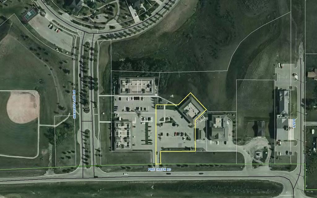
23 MISCELLANEOUS PLANNING ITEM APPLICATION FOR DEVELOPMENT PERMIT 17D 263 DIRECT CONTROL DISTRICT #11 January 10 th, 2018 LANDOWNER: Heritage Pointe Crossing Inc. LEGAL: Plan Block 5, Lot 3; S W4M EXISTING PARCEL: PTN. of 1.04 acres NUMBER OF PROPOSED NEW PARCELS: N/A APPLICANT: Same DIVISION: #6 Larry Spilak EXISTING LAND USE: Direct Control District #11 Heritage Pointe Commercial Site FILE MANAGER: Brenda Bartnik PROPOSAL: Request to allow for the operation of a preschool, and before and after school care facility in Bay #220 at this location. LOCATION: The subject property is located at # Pine Creek Road, within the Heritage Pointe Commercial Site that is located on the northeast corner of the intersection at Heritage Lake Drive and Pine Creek Road, adjacent to the north side of Dunbow Road. POLICY AREA: The site is located within the boundaries of the Heritage Pointe Area Structure Plan and within the Interface Area of the M.D. of Foothills and The City of Calgary Intermunicipal Development Plan, as well as the Central District under the Growth Management Plan. Land use is guided by the Municipal Development Plan 2010 and governed by the Land Use Bylaw 60/2014. BACKGROUND: The Heritage Pointe Commercial Site was included within the Heritage Pointe Area Structure Plan that was adopted in March of In April of 2006, approval was granted under development permit 06D 052 for a 5,200 sq. ft. building containing space for four commercial bays, along with supporting development, on the east side of the Site. While the most recent approval that was issued under development permit 16D 016 allowed for the operation of a restaurant in the subject 1,043 sq. ft. bay, pre-release conditions of the issued approval were not fulfilled and the business did not proceed to operate. The last known operating business at bay #220 was a bakery/café under development permit 13D 007. Active Development Permits that exist for the other bays in this building are: - Liquor store Page 23
24 - Spa services with a coffee shop as an accessory use PROPOSAL: The landowner/applicant is proposing to lease a bay (#220) having an area of approximately 1,043 sq. ft., to be used for the operation of a preschool and before and after school care facility. The identified operator has been sharing space in a condominium unit to the west of this location, within the Heritage Pointe Commercial Site. A preschool has been in operation there since early 2016, under development permit 15D 219. At this time, it is proposed that the facility relocate and offer additional services. Operations are proposed to include: - Pre-school and Kindergarten classes, 2 per day (9:00 AM 11:15 AM and 12:00 PM 2:15 PM) - Before school care drop off (by parents/private caregivers) would begin at 7:00 AM and last pick up would be at 6:00 PM. Transportation to and from school is to be provided via school bus, using the current stop that is located at the end of the parking lot. - Summer and school break care is proposed to be offered to registered families (7:00 AM 6:00 PM). - Total maximum attendance 38 children, ages pre-school through to Other than walking to existing nearby facilities (playground, tennis courts), no off-site field trips are planned at this time. - A maximum of 6 employees may attend the property. - Parking is available under the common area stalls that are located within the boundaries of the commercial site. Drop off and pick up visits are anticipated to be of short duration between 7 9 AM, 11:15 12:30, and 5 6 PM daily. Parking immediately in front of the premises is signed 15 minutes only. Events (ie: preschool graduation, which occurs once during daytime hours, in June) have been limited to children in the program only. It is not expected that there will be anything more than passenger vehicles attending the lot in relation to the facility. - Fascia signage will comply with the existing, approved signage at the commercial site. - The site is connected to water and wastewater servicing. - Landscaping and stormwater management facilities exist under prior approvals. An Emergency Action Plan has been provided by the operator and is currently under review by municipal Emergency Management and Fire Services. POLICY / PLANNING CONSIDERATIONS: MUNICIPAL GOVERNMENT ACT DIRECT CONTROL DISTRICTS Section 641(2) If a direct control district is designated in a land use bylaw, the council may, subject to any applicable statutory plan, regulate and control the use or development of land or buildings in the district in any manner it considers necessary. Page 24
25 MDP 2010: ECONOMY Commercial Development Commercial use includes businesses such as stores, offices, gas stations and restaurants. Hamlets, both existing and new, as well as service nodes in planned communities, may be suitable for commercial development. Location 4. Industrial and commercial developments shall be encouraged to locate in existing and new industrial and commercial parks, or in Hamlets where plans are in place to allow for these developments and where they can serve the everyday needs of the surrounding community. GROWTH MANAGEMENT STRATEGY This parcel falls within the Central District of the Growth Management Strategy. VISION The Central District of the MD has been the growth engine for the MD and this trend is expected to continue into the future. While significant development and intensification of development is expected in this area, it will need to be undertaken bearing in mind the aspirations of our municipal neighbours and with due consideration to riparian and wetland areas. Opportunities for joint initiatives will play a key role in providing effective, efficient and affordable services for this area." Planning for Industrial and Commercial Development Following are some strategies to mitigate land use conflicts created by industrial and commercial development in the MD: - Support commercial developments in hamlets and new comprehensively planned community development and/or redevelopment areas on the basis of an approved Area Structure Plan, Outline Plan or Area Redevelopment Plan; - Remain cognizant of all the impacts of commercial and industrial development on existing land uses when considering applications for new development; HERITAGE POINTE AREA SUTRUCTURE PLAN Community Services - Services necessary to support the local and surrounding residential population and contribute to the overall lifestyle of the community should be encouraged. Retail/Commercial - Commercial facilities for Heritage Pointe are to be located at the intersection of the service/collector roadway. - Allowable uses may include restaurants, general store, post office, sale of gifts, handicrafts, jewelry, and/or clothing, personal and financial services, general office, inn, and/or gas bar. LAND USE BYLAW DEFINITIONS DAY CARE FACILITY means the use of a building or portion thereof for the provision of care, instruction, maintenance or supervision of seven or more children under the age of 13 years, by persons other than one related by blood or marriage, for periods not exceeding 24 consecutive Page 25
26 hours and includes all daycare centers, early childhood services, nurseries and after-school or baby-sitting programs which meet this definition. COMMUNITY SERVICES means a development for the purpose of providing educational, recreational, social, and/or religious services and for avoidance of doubt including but not limited to Agricultural Society Grounds, Cemeteries, Churches, Public, Separate, and Private schools, and Community Buildings /Facilities. CHILD CARE FACILITIES In accordance with Section 2.5 Definitions, Childcare facilities have been separated into categories as per the following: a. Day Care Facility means the use of a building or portion thereof for the provision of care, instruction, maintenance or supervision of seven or more children under the age of 13 years, by persons other than one related by blood or marriage, for periods not exceeding 24 consecutive hours and includes all day-care centres, early childhood services, nurseries and after-school or babysitting programs which meet this definition; b. Day Home Services means when a dwelling unit is used to provide for the care and supervision of six or fewer children under the age of 13 years for a fee, by a person who resides in the dwelling unit, for periods of less than twenty four (24) consecutive hours, other than institutions operated by or under the authority of the Director of Child Welfare When considering an application for the development of a childcare facility the Development Authority shall take into account the size, configuration and quality of the site and associated buildings, adjacent land uses, potential traffic generation, proximity to parks, open spaces or recreation areas and potential impacts on other development in the surrounding area The Development Authority shall establish the maximum number of children for whom care may be provided, having regard for the above noted definitions, provincial regulations, the nature of the facility and the density of development in the district in which it is located The Development Authority may consult with provincial and municipal child service agencies prior to making a decision on a Development Permit for a Childcare Facility Parking facilities for approved Childcare Facilities shall meet the requirements of Section PARKING AND LOADING FACILITIES In the case of a use not specified in Table 9.19 B through Table 9.19 F, the number of parking stalls provided shall be the same as for a similar use as determined by the Approving Authority. At the time that plans for the Commercial District were approved by Municipal Council, the developer submitted a Site and Vicinity Plan identifying that there were 149 stalls provided in all phases of the complex to accommodate parking. Based upon existing tenants and including this use, the number of stalls required appears to meet current guidelines. Areas available for the unloading of deliveries for supplies related to business operations are limited. Restrictions may need to be placed on the type of delivery vehicles and/or the timing of deliveries. Page 26
: In Township 22, Range 29, West 4 Meridian: Portion of Fractional South Half Section 6;")
27 DIRECT CONTROL DISTRICT #11 (DC11) PURPOSE AND INTENT The purpose and intent of this district is to allow for a wide range of commercial uses consistent with the Heritage Pointe Area Structure Plan and Direct Control by the Council over the development on the following lands (Heritage Pointe Commercial Site): In Township 22, Range 29, West 4 Meridian: Portion of Fractional South Half Section 6; In Township 22, Range 1, West 5 Meridian: Portion of South East Quarter of Section 1 Total of 3.61 acres PERMITTED USES Convenience / Grocery Store Public Works Restaurants Service Station Signs not requiring a development permit DISCRETIONARY USES Accessory Uses Appliance Service and Repair Auto Sales and Service Business Offices (i.e. Veterinarian, Medical Doctor, Dentist, Lawyer, Small Business Centre) Community services (i.e. Fitness Facility, Library, Recycle) Country Recreational Centre / Lodge Day Care Center Dwelling Single Family Farm Equipment and Sales Hotel / Motel Public Quasi Public Installations and Facilities Page 27
28 Retail and Wholesale Outlets (i.e. Post Office, Dry Cleaner, Beauty Salon/Spa, Coffee Shop, Liquor Store, Video Store, Art Market) Signs requiring a Development Permit REQUIREMENTS Standards of the development shall be at the discretion of Council. MINIMUM REQUIREMENTS Area of Lot: Area shown on Certificate of Title; or Area allowed for by bylaw amending this section Minimum Yard Setback Requirements: Front Yard Setback: i. 4m (13.12 ft.) from an Internal Subdivision Road Property Line ii. 38m ( ft.) from the center line of a Municipal Road iii. 64m ( ft.) from the center line of a Secondary Highway iv. 40m ( ft.) from a Primary Highway Side Yard Setback: i. 1.5m (4.92 ft.) from property line Rear Yard Setback i. 6m (19.69 ft.) from property line MAXIMUM LIMITS Number of Lots At the discretion of Council Height of Buildings: 12m (39.37 ft.) or If higher than 12m, at the discretion of Council Coverage of Lot: 60% PROCEDURE Notwithstanding the procedure established for development permit applications in Section 4 and Section 5, an application for development permit in respect of lands referred to in Section shall be referred by the Development Officer to the Council for its approval or refusal Notwithstanding the procedure established for the issuance of development permits in Section 5, the Council shall decide on all applications for development permits with respect to lands referred to in Section The council may approve a development permit application with or without conditions, or may reuse an application for development permit. Municipal District of Foothills No Land Use Bylaw There is no appeal to the Development Appeal Board from a decision of the Council on an application for a development permit in respect of the lands referred to in Section CIRCULATIONS: Public Works City of Calgary Alberta Health Services Has no comments. The City of Calgary has no comments regarding 17D 263 Day Care. The owner/operator is required to: - submit design plans for this facility to AHS prior to construction for review. - meet the applicable AHS regulations under the Alberta Public Health Page 28
29 Municipal Fire Services Safety Codes Officer Act (RSA 2000). - be inspected and approved by AHS prior to opening to the public. AHS recommends that a business license not be issued until proof of AHS approval is provided by the owner operator. Requires a fire Inspection prior to occupancy. Proper address signage must be in place. An emergency response plan must be implemented and maintained. Design must be submitted that shows the change in occupancy and that it meets with the Alberta Building Code. Ie: washrooms, barrier free access, any kitchen installations. OPTIONS FOR CONSIDERATION: Following are three (3) possible options for Council s consideration: OPTION #1: APPROVAL Council may choose to grant approval for a Development Permit with the accompanying recommended conditions and/or with revised conditions of their choosing. PRE-RELEASE CONDITION (Condition must be complied with before the Development Permit will be signed and released): 1. The applicant is required to submit a refundable security deposit in the amount of $3,000 in order to ensure compliance with the Alberta Building and Fire Codes for the proposed use and occupancy of the development. This security will be refunded at such time final confirmation for occupancy of the bay is provided by the Municipal Safety Codes Officer and Municipal Fire Services. ADDITIONAL CONDITIONS 1. This approval is for the operation of a facility providing preschool and kindergarten educational services, as well as before and after school care, in Bay #220, PTN: S W4M, Plan , Block 5, Lot 3. Addition to, or revision to the approved use(s) of this land may proceed only upon obtaining appropriate municipal approvals; 2. the applicant shall maintain the development in accordance with all conditions of approval and plans as submitted with the application for permit that have been acknowledged to be appropriate; 3. no greater than 38 children may attend the site for education and/or care, at any given time; 4. it is the responsibility of the applicant to submit plans for interior design that verify the development meets the requirements of the Alberta Building Code for the intended use and occupancy. The applicant shall obtain any necessary Building and Safety Code Permits and must ensure compliance with the requirements of the Alberta Building, Plumbing, Electrical and Fire Codes at all times; 5. prior to occupancy of the subject bay, the applicant is responsible to contact Municipal Fire Services to arrange for a fire inspection. Appropriate municipal addressing, and an emergency response plan, must be maintained at all times; Page 29
30 6. any signage is required to be similar to the signs currently found within the Heritage Pointe Commercial Site. A detailed plan for signage shall be submitted to the development office for acceptance prior to installation; 7. days and hours of operation are permitted from Monday through Friday from 6:00 AM until 7:00 PM; 8. operations and involved related use (ie: parking/loading) shall at all times be wholly located within the boundaries of the legally titles lot; 9. all garbage and recycling materials shall be stored in weather-proof and animal-proof containers that are required to be visibly screened from adjacent lands; 10. any required permits or licensing from Provincial bodies must be obtained including, but not limited to, any necessary licensing from Alberta Child and Family Services and Alberta Health Services. Prior to operating, the applicant shall provide the municipality with proof that such licensing is in place; 11. it is the landowner s responsibility to provide notification to the Development Authority upon completion of the development; 12. the issuance of a permit from the Municipality does not relieve the applicant of the responsibility of complying with all relevant municipal bylaws and requirements, nor excuse violation of any provincial or federal regulation or act which may affect use of the land; 13. the applicant shall be responsible for payment of any professional costs including legal fees that may be incurred by the M.D. with respect to the is permit. OPTION #2 TABLE APPLICATION Council may choose to table the application and request submission of any additional information and/or request any action that would confirm suitability of the proposal (including, but not limited to the request for a Public Meeting with the applicant), at their discretion. OPTION #3: REFUSAL Council may choose to refuse the application for a Development Permit if it is of the opinion that the application does not satisfactorily conform to those policies that guide use of this land; and/or that the development as proposed is contrary to section 617 of the Municipal Government Act of Alberta. ENCLOSURES: LOCATION MAP PROPOSED SITE SITE DETAILS COMMERCIAL SITE PICTURES Page 30

31 Page 31 LOCATION MAP

32 Page 32 PROPOSED SITE
33 SITE DETAILS Day Care Page 33

34 Page 34 PICTURES
35 MISCELLANEOUS PLANNING ITEM PLANNING AND DEVELOPMENT REPORT 2 ND & 3 RD READING January 10 th, 2018 COUNCIL ACTION REQUIRED: 2 nd and 3 rd Reading of Bylaw 49/2017 LANDOWNERS: Lucas & Leslie Waldner LEGAL DESCRIPTION: NW W5M; Plan , Block 4, Lot 1 EXISTING PARCEL: Acres NUMBER OF PROPOSED NEW PARCELS: 1 x 5.04+/- acres AGENT: N/A DIVISION: #2 Delilah Miller EXISTING LAND USES: CR Country Residential FILE MANAGER: Drew Granson Application for amendment of the Country Residential land use district rules to allow for the creation of one parcel of 5.04+/- acres, leaving a balance of 5.04+/- acres. The proposed parcel is to be designated as CR-A and the balance parcel to remain be designated as CR. BACKGROUND: 1 ST READING: May 31 st, 2017 BYLAW: 49/2017 On May 31 st, 2017, Council gave first reading to Bylaw 49/2017 authorizing land use bylaw amandment of the Country Residential District land use rules to allow for the future subdivision of one additional 5.04+/- acre parcel from Plan , Block 4, Lot 1; NW W5M. The proposed parcel is to be designated as Country Residential Subdistrict A to ensure that all recommendations and restrictions as outlined in High Water Table Testing for foundation and septic system designs, septic disposal evaluation and identified building envelope, each provided as conditions Subdivision approval are complied with as conditions of the Development Permit. CONDITIONS MET AT REDESIGNATION: All conditions of Land Use Amendment have been met. COUNCIL ACTION REQUIRED: Requesting 2 nd & 3 rd reading of Bylaw 49/2017. Please note: Current Council Members present at time of 1 st reading; Reeve Larry Spilak, Deputy Reeve Delilah Miller, Councillor Jason Parker, and Councillor Suzanne Oel ENCLOSURES: Location Map Lot Ortho Proposed Site Plan Page 35

36 Page 36 Subject Property

37 LOT ORTHO Proposed: CR-A 5.04+/- acres Balance: CR 5.04+/- acres Page 37
38 SUBMITTED SITE PLAN Page 38
39 MISCELLANEOUS PLANNING ITEM PLANNING AND DEVELOPMENT REPORT 2 ND & 3 RD READING January 10, 2018 COUNCIL ACTION REQUIRED: 2 nd and 3 rd Reading of Bylaw 88/2017 LANDOWNER: Sanja Holdings LEGAL DESCRIPTION: SE W5M EXISTING PARCEL: 160 +/- Acres NUMBER OF PROPOSED NEW PARCELS: 1 x /- acre parcel AGENT: Sidney Sutton DIVISION: #2 Delilah Miller EXISTING LAND USE: A Agricultural FILE MANAGER: Drew Granson The purpose of this application is to redesignate a portion of SE W5M from Agricultural Land Use District to Country Residential Land Use District to allow for the future subdivision of one /- acre Country Residential parcel, leaving a balance of /- acres to remain as Agricultural Land Use District. BACKGROUND: 1 ST READING: November 1 st, 2017 BYLAW: 88/2017 On November 1 st, 2017, Council gave first reading to Bylaw 88/2017 authorizing the redesignation of a portion of SE W5M from Agricultural Land Use District to Country Residential A District to allow the future subdivision of one additional 11.7+/- acre parcel, with the balance of /- acres to remain designated as Agricultural Land Use District. The new lot will be designated as Country Residential A District to ensure that all future structures meet municipal setbacks. Note: The purpose of designating the proposed parcel as CR-A District is to ensure that all future structures meet municipal setback requirements. Council may consider redesignation to standard Country Residential land use district as setback requirements are addressed under the Section Development Requirements of the Country Residential District. CONDITIONS MET AT REDESIGNATION: All conditions of Redesignation have been met. COUNCIL ACTION REQUIRED: Requesting 2 nd & 3 rd reading of Bylaw 88/2017. ENCLOSURES: Location & Land Use Map Submitted Site Plan Lot Ortho Page 39

40 Subject Property Page 40
41 Submitted Site Plan Page 41
42 Balance: A /- acres Proposed: CR-A 11.7+/- acres Page 42
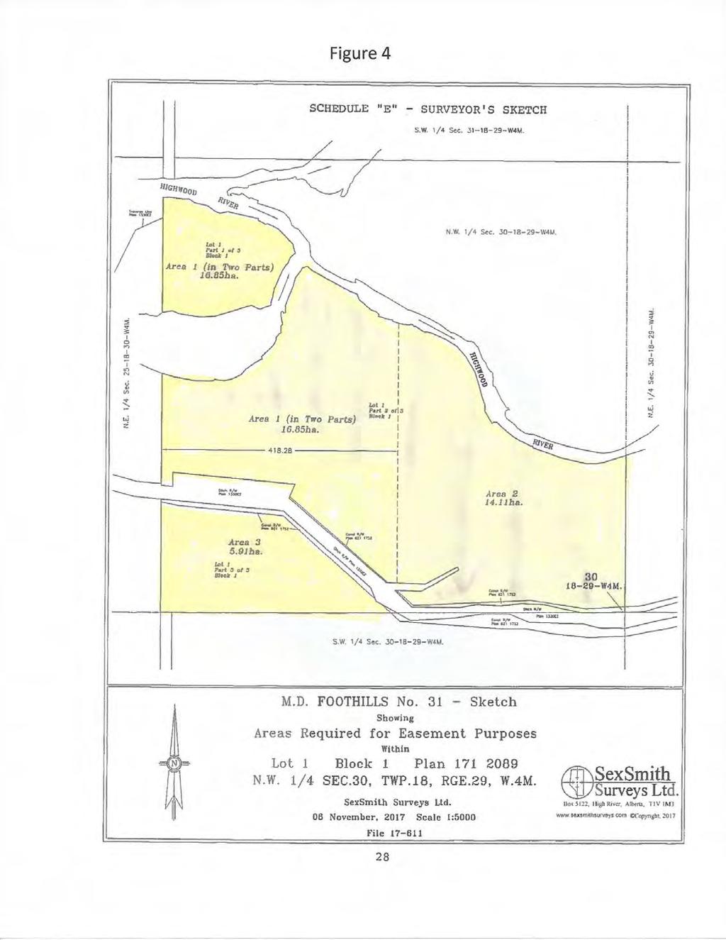
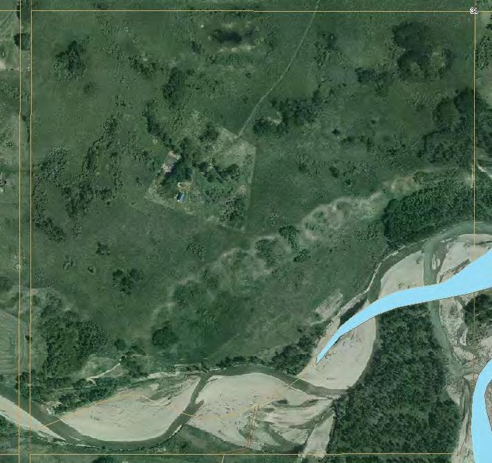
43 MISCELLANEOUS PLANNING ITEM PLANNING AND DEVELOPMENT REPORT Pending Conservation Easement Requests January 10 th, 2018 COUNCIL ACTION REQUIRED: Council is requested to acknowledge the pending Conservation Easement. and agree to waive 60 day notice period requirement. LANDOWNER: Highwood Valley Ranch Ltd. LAND TRUST ORGANIZATION: Foothills Land Trust LEGAL DESCRIPTION: NW W4M EXISTING PARCEL: acres in total DIVISION #1 Rob Siewert PLANNING OFFICER Theresa Chipchase BACKGROUND: The Foothills Land Trust is providing notice to the Municipality as per Section 33(2)(iii) of the Alberta Land Stewardship Act of their intention to register a conservation easement on lands within the MD of Foothills. The conservation easement will effect the land described as NW W4M, containing acres, owned by Highwood Valley Ranch Ltd. Council is requested to acknowledge the pending Conservation Easement. and to agree in writing to waive the 60 day notice period required under Section 2(1)(3) of the Conservation Easement Registration Regulations as set out in Section 33(1) of the Alberta Land Stewardship Act, allowing the Trust to register the easement immediately on the lands described above. COUNCIL ACTION REQUIRED: Council to acknowledge the Conservation easement and either agree or disagree to waive the 60 day notice period for registration of the agreement as identified in the attached documentation. The purpose of the easement is provided within the letter of explanation provided by the Foothills Land Trust, attached to this staff report. ENCLOSURES: Location Map Ortho Maps Notice prior to registration - Submitted by Foothills Land Trust Page 43

44 LOCATION MAP Subject Parcel Hwy 543 Coal Trail High River Hwy 23 Hwy 2 Page 44

45 ORTHO PHOTOS NW W5M Page 45
46 NOTICE PRIOR TO REGISTRATION SUBMITTED BY FOOTHILLS LAND TRUST Page 46
47 Page 47
48 Page 48
49 Page 49
50 MISCELLANEOUS PLANNING ITEMS PLANNING AND DEVELOPMENT REPORT 2 ND AND 3 RD READING OF BYLAW January 10 th, 2018 Council Action Required: 2 nd and 3 rd Reading of Bylaw 40/2017 LANDOWNER: Victor and Phyllis Bayly LEGAL DESCRIPTION: NE W5M EXISTING PARCEL: acres NUMBER OF PROPOSED NEW PARCELS: 2 x 3.65 and /- acre CR District parcels AGENT: none DIVISION: #4 Suzanne Oel EXISTING LAND USE: A Agricultural District FILE MANAGER: Theresa Chipchase PROPOSAL: This application is redesignate a portion of the NE W5M from the Agricultural Land Use District to the Country Residential Land Use District in order to allow for the future subdivision of one 3.65+/- acre and one /- acre Country Residential parcels with a /- acre Agricultural balance. The application also granting all three readings rescinding Bylaw 208/2006, which was the Coyote Crossing Area Structure Plan. BACKGROUND: 1 ST READING: May 10 th, 2017 BYLAW: 40/2017 October 11 th, Council approved a land use application, rezoning a portion of the NE W5M from Agricultural District to Country Residential A District under the following motion: Council gave first reading to Bylaw 40/2017 authorizing the redesignation of a portion of NE W5M from Agricultural District to Country Residential A District in order to permit the future subdivision of two new /- acre and /- acre Country Residential A lots. CONDITIONS MET AT REDESIGNATION: The applicants have complied with all conditions of the first reading approval. COUNCIL ACTION REQUIRED: Requesting Council grant 2 nd & 3 rd reading to Bylaw 40/2017. Page 50
51 ENCLOSURES: Location Map Land Use Map Lot Ortho Site Plan Page 51

52 LOCATION MAP City of Calgary Hwy 22X Priddis Hwy 22 Hwy 552 Hwy 549 Millarville Hwy 549 Subject Parcel Page 52

53 LAND USE MAP Subject Parcel Page 53

54 Page 54 LOT ORTHO
55 SITE PLAN Proposed subdivision Page 55
56 MISCELLANEOUS PLANNING ITEMS PLANNING AND DEVELOPMENT REPORT 2 ND AND 3 RD READING OF BYLAW January 10 th, 2017 Council Action Required: 2 nd and 3 rd Reading of Bylaw 84/2017 LANDOWNER: Luc Tierens and Michelle Verlinden LEGAL DESCRIPTION: NW W5M EXISTING PARCEL: acres NUMBER OF PROPOSED NEW PARCELS: 1 x 9.7 +/- CR District parcel AGENT: none DIVISION: #2 Delilah Miller EXISTING LAND USE: A Agricultural District FILE MANAGER: Theresa Chipchase PROPOSAL: This application is to redesignate a portion of the parcel from Agricultural Land Use District to Country Residential Land Use District in order to allow for the future subdivision of one 9.7 +/- acre Country Residential parcel with an /- acre Agricultural balance. BACKGROUND: 1 ST READING: October 11 th, 2017 BYLAW: 84/2017 October 11 th, Council approved a land use application, rezoning a portion of the NW W5M from Agricultural District to Country Residential District under the following motion: Council gave first reading to Bylaw 84/2017 authorizing the redesignation of a portion of NW W5M from Agricultural District to Country Residential District to allow the future subdivision of one new 9.7+/- acre lot. Council is of the opinion that the proposal is in alignment with the intent and policy outlined in the Residential section of the MDP2010 and that the application falls within the density provisions and lot size restrictions for Country Residential development. CONDITIONS MET AT REDESIGNATION: The applicants have complied with all conditions of the first reading approval. COUNCIL ACTION REQUIRED: Requesting Council grant 2 nd & 3 rd reading to Bylaw 84/2017. Page 56
57 ENCLOSURES: Location Map Land Use Map Lot Ortho Site Plan Page 57
58 H LOCATION MAP Hwy 543 City of Calgary Hwy 22 Hwy 2 High River Hwy 2A Hwy 541 Dunbow Rd. Longview Hwy 543 High River Hwy 23 Hwy 540 Subject Parcel Page 58
59 LAND USE MAP Subject Parcel Page 59
60 Page 60 LOT ORTHO
61 Page 61 SITE PLAN
62 MISCELLANEOUS PLANNING ITEM PLANNING AND DEVELOPMENT REPORT Pending Conservation Easement Requests January 10 th, 2018 COUNCIL ACTION REQUIRED: Council is requested to acknowledge the pending Conservation Easement. and agree to waive 60 day notice period requirement. LANDOWNER: Chinook Valley Inc. LAND TRUST ORGANIZATION: Western Sky land Trust Society LEGAL DESCRIPTION: SW/NW W5M north of Sheep River EXISTING PARCEL: acres in total DIVISION #5 Alan Alger PLANNING OFFICER Theresa Chipchase BACKGROUND: The Western Sky Land Trust Society is providing notice to the Municipality as per Section 33(2)(iii) of the Alberta Land Stewardship Act of their intention to register a conservation easement on lands within the MD of Foothills. The conservation easement will effect the land described as SW W5M and NW W5M, both north of the Sheep River, containing acres, owned by Chinook Valley Inc. Council is requested to acknowledge the pending Conservation Easement. and to agree in writing to waive the 60 day notice period required under Section 2(1)(3) of the Conservation Easement Registration Regulations as set out in Section 33(1) of the Alberta Land Stewardship Act, allowing the Trust to register the easement immediately on the lands described above. COUNCIL ACTION REQUIRED: Council to acknowledge the Conservation easement and either agree or disagree to waive the 60 day notice period for registration of the agreement as identified in the attached documentation. The purpose of the easement is provided within the letter of explanation provided by thw Western Sky Land Trust, attached to this staff report. ENCLOSURES: Location Map Ortho Maps Notice prior to registration - Submitted by Western Sky Land Trust Page 62

63 LOCATION MAP Subject Parcels Millarville Hwy 549 Hwy 22 Hwy 7 Black Diamond/Turner Valley Hwy 546 Page 63

64 ORTHO PHOTOS NW W5M Page 64
65 SW W5M Page 65
66 NOTICE PRIOR TO REGISTRATION FROM WESTERN SKY LAND TRUST Page 66

67 Page 67
68 Page 68
69 SUBDIVISION APPROVING AUTHORITY ITEM PLANNING AND DEVELOPMENT REPORT SUBDIVISION APPROVAL January 10, 2018 LANDOWNER: Sanja Holdings LEGAL DESCRIPTION: SE W5M EXISTING PARCEL: 160 +/- Acres NUMBER OF PROPOSED NEW PARCELS: 1 x /- acre parcel AGENT: Sidney Sutton DIVISION: #2 Delilah Miller EXISTING LAND USE: A Agricultural FILE MANAGER: Drew Granson PROPOSAL: This is an application for Subdivision of the subject parcel for the creation of one 11.7+/- acre Country Residential Sub A parcel, leaving a balance of /- acres to remain as Agricultural land use district. BACKGROUND: 1 ST READING: November 1 st, 2017 BYLAW: 88/2017 On November 1 st, 2017, Council gave first reading to Bylaw 88/2017 authorizing the redesignation of a portion of SE W5M from Agricultural Land Use District to Country Residential A District to allow the future subdivision of one additional 11.7+/- acre parcel, with the balance of /- acres to remain designated as Agricultural Land Use District. SUBDIVISION APPROVING AUTHORITY ACTION REQUESTED: Requesting subdivision approval for one 11.7+/- acre Country Residential parcel, leaving a balance of /- acres to remain as Agricultural Land Use. No letters have been received regarding this proposed subdivision. RECOMMENDED CONDITIONS OF SUBDIVISION: Subdivision to be effected by Plan of Survey, pursuant to Section 657 of the Municipal Government Act, or such other means satisfactory to the Registrar of the South Alberta Land Titles District; Completion of all pre-release conditions as noted in the executed Municipal Development Agreement to the satisfaction of the Municipality. These conditions include: Payment of the $11, per new lot Community Sustainability Fee; Landowners are to provide all utility easements and agreements to the satisfaction of the MD and the utility companies; Landowners are to pay all arrears of taxes on the existing parcel prior to finalization of the subdivision; Submission of final Subdivision lot fees; Landowners are to sign Road Acquisition Agreements for 5 Meters along the entire east boundary of the subject quarter section and for 5 meters along the entire south boundary Page 69
70 of the subject quarter section, to the satisfaction of the Municipal Public Works Department; It is the applicant s responsibility to provide a Real Property Report or an as built drawing signed and sealed by an Alberta Land Surveyor, certifying the location of the adjacent municipal road(s), within the boundaries of the new and balance parcel and that the site plan is surveyed according to municipal setback requirements. Public Reserve to be deferred on the balance parcel; ENCLOSURES: Location & Land Use Map Submitted Site Plan Lot Ortho Assessment Spreadsheet Page 70

71 Subject Property Page 71
72 SUBMITTED SITE PLAN Page 72

73 Balance: A /- acres Proposed: CR-A 11.7+/- acres Page 73

74 ASSESSMENT SPREADSHEET Page 74

75 SUBDIVISION APPROVING AUTHORITY ITEMS PLANNING AND DEVELOPMENT REPORT SUBDIVISION APPROVAL January 10 th, 2017 SUBDIVISION APPROVING AUTHORITY ACTION REQUIRED: Subdivision Approval LANDOWNERS: Luc Tierens and Michelle Verlinden AGENT: None LEGAL DESCRIPTION: NW W5M EXISTING PARCEL: acres PROPOSAL: Subdivision one 9.7 +/- ac Country Residential parcel DIVISION #2 Delilah Miller PLANNING OFFICER - Theresa Chipchase BACKGROUND: 1 ST READING: October 11 th, 2017 BYLAW: 84/ rd READING DATE: January 10 th, 2018 SUBDIVISION APPROVING AUTHORITY ACTION REQUIRED: Requesting subdivision approval for one /- acre Country Residential parcel. Council may choose to consider the following conditions: RECOMMENDED CONDITIONS OF SUBDIVISION: Subdivision to be effected by Plan of Survey, pursuant to Section 657 of the Municipal Government Act, or such other means satisfactory to the Registrar of the South Alberta Land Titles District; It is the applicant s responsibility to provide a Real Property Report or an as built drawing signed and sealed by an Alberta Land Surveyor, certifying the location of the adjacent municipal road(s), water wells within the boundaries of the new and balance parcels and that the site plan is surveyed according to municipal setback requirements; All accesses to be located and culverts and approaches to be installed to current MD subdivision road standards, to the satisfaction of the municipality s public works department; Completion of all conditions as noted in the executed Municipal Development Agreement to the satisfaction of the MD and where applicable the appropriate external agencies. These conditions are: Payment of the $11,000 per new lot community sustainability fee; All required utility easements and agreements to the satisfaction of the municipality and the utility companies; Page 75
76 All arrears of taxes are to be paid on the existing parcels prior to finalization of the subdivision; Submission of final subdivision lot fees; ENCLOSURES: Location Map Land Use Half Mile Map Site Plan Ortho Photo Page 76

77 LOCATION MAP Hwy 543 Hwy 22 High River Hwy 541 Longview Hwy 540 Subject Parcel Page 77

78 LAND USE Subject Parcel Page 78
79 HALF MILE MAP (LOT SIZES) Subject Parcel Page 79
80 Page 80 SITE PLAN

81 LOT ORTHO 4.0+/- AC 4.0+/- AC 4.0+/- AC Page /- AC 4.0+/- AC
MUNICIPAL DISTRICT OF ROCKY VIEW NO. 44 ELBOW VALLEY WEST DIRECT CONTROL DISTRICT BYLAW C
 This document has been consolidated for convenience only. A current listing of any and all amendments can be obtained from the Municpal District Office Bylaw No. Date of Approval Amendment Type Bylaw C-6042-2005
*1. Trudy Halverson NE W4 Bylaw 1/2018 Further Consideration of Conditions
 MUNICIPAL DISTRICT OF FOOTHILLS NO. 31 April 18, 2018 Location: M.D. of Foothills Administration Office 309 Macleod Trail South High River COUNCIL AGENDA A. GENERAL MATTERS 1. Call Meeting to Order 2.
The Council of the Municipal District of Foothills No. 31 met at the Foothills Administration Building, High River, Alberta, for a meeting on
 The Council of the Municipal District of Foothills No. 31 met at the Foothills Administration Building, High River, Alberta, for a meeting on September 13, 2017 at 9:00 a.m. Present were Mayor L. Spilak,
Samantha Payne Pg. 25 1:30 pm *3. Annual Fee Bylaw Amendment Request for 2 nd & 3 rd Reading
 MUNICIPAL DISTRICT OF FOOTHILLS NO. 31 December 12, 2018 Location: M.D. of Foothills Administration Office 309 Macleod Trail South High River COUNCIL AGENDA A. GENERAL MATTERS 1. Call Meeting to Order
Prt. NE W5. Prepared for: Municipal District of Foothills #31. Prepared by:
 Prt. NE 22-22-3-W5 Prepared for: Municipal District of Foothills #31 Prepared by: Bowwood Land Services Inc. R.R. 1, Dewinton, Alberta T0L 0X0 Tel: 403-995-2225 Fax: 403-938-4787 " OFFICIAL COPY " ADOPTED
UPPER MOUNT BETHEL TOWNSHIP NORTHAMPTON COUNTY, PENNSYLVANIA
 UPPER MOUNT BETHEL TOWNSHIP NORTHAMPTON COUNTY, PENNSYLVANIA JOINDER DEED / LOT CONSOLIDATION TOWNSHIP REVIEW PROCESS When accepting proposed Joinder Deeds / Lot Consolidations, review the Joinder Deed
OFFICE CONSOLIDATION
 OFFICE CONSOLIDATION This document has been consolidated for convenience only. A copy of the original Bylaw and all amending Bylaws can be obtained from Rocky View County. This office consolidation comprises
2.35 BVT G Bow Valley Trail General Commercial District [ ]
![2.35 BVT G Bow Valley Trail General Commercial District [ ]](/thumbs/94/119006025.jpg "2.35 BVT G Bow Valley Trail General Commercial District [ ]") 2.35 BVT G Bow Valley Trail General Commercial District [2014 07] 2.35.1 Purpose This district is intended to form the core of Canmore s visitor accommodation outside the resorts and provide a variety
2.35 BVT G Bow Valley Trail General Commercial District [2014 07] 2.35.1 Purpose This district is intended to form the core of Canmore s visitor accommodation outside the resorts and provide a variety
FOR DISCUSSION PURPOSES ONLY EDMONTON INTERNATIONAL AIRPORT VICINITY PROTECTION AREA REGULATION
 *UPDATES TO AN EXISTING REGULATION EDMONTON INTERNATIONAL AIRPORT VICINITY OTECTION AREA REGULATION Table of Contents 1 Definitions 2 Protection Area established 3 Subdivision approval and development
ARTICLE V AGRICULTURAL PRESERVATION AND RURAL RESIDENTIAL DISTRICT
 ARTICLE V AP AGRICULTURAL PRESERVATION AND RURAL RESIDENTIAL DISTRICT Section 500. PURPOSE It is the purpose of the AP, Agricultural Preservation and Rural Residential District, to foster the preservation
To ensure a smooth transition from the County to City jurisdiction for planning and development regulation
 City of Grande Prairie Municipal Development Plan and Land Use Bylaw Concept for transitioning Short Term Annexation Area lands into the City s policy framework and land use development control regime.
ACCESSORY DWELLING UNITS
 ACCESSORY DWELLING UNITS LAND USE BYLAW C-4841-97 ACCESSORY DWELLING UNIT (ADU): means a subordinate dwelling unit attached to, created within or detached from the principal dwelling, single detached,
RURAL GENERAL RG 1. PERMITTED USES DISCRETIONARY USES
 RURAL GENERAL RG PURPOSE: To protect the agricultural land base of the municipality while allowing nonagricultural developments which complement the area's economy. 1. PERMITTED USES DISCRETIONARY USES
SECTION 817 "AL" - LIMITED AGRICULTURAL DISTRICT
 SECTION 817 "AL" - LIMITED AGRICULTURAL DISTRICT The "AL" District is a limited agricultural district. It is intended to protect the general welfare of the agricultural community by limiting intensive
LAND USE BYLAW NO. 747
 TOWN OF PICTURE BUTTE LAND USE BYLAW NO. 747 Prepared by the OLDMAN RIVER INTERMUNICIPAL SERVICE AGENCY June 1998 Amended to Bylaw No. 792-06 TABLE OF CONTENTS TITLE... 1 DATE OF COMMENCEMENT... 1 REPEAL
MUNICIPAL DEVELOPMENT PLAN
 MUNICIPAL DEVELOPMENT PLAN Prepared by: The Council and Planning and Development Services Bylaw No. 1414-09 adopted August 12, 2009 Amending Bylaw - 1480-12 adopted June 12, 2013 Amending Bylaw 1529-14
C-2B District Schedule
 District Schedule 1 Intent The intent of this Schedule is to provide for a wide range of goods and services, to maintain commercial activities and personal services that require central locations to serve
Financial Impact Statement There are no immediate financial impacts associated with the adoption of this report.
 STAFF REPORT Planning and Development Department Subject: Application by RYC Property to rezone a portion of lands on John Murray Dr. and Megan Lynn Dr. from R2 to R3 and to enter into a Development Agreement
ARTICLE 143. PD 143.
 ARTICLE 143. PD 143. SEC. 51P-143.101. LEGISLATIVE HISTORY. PD 143 was established by Ordinance No. 17685, passed by the Dallas City Council on February 2, 1983. Ordinance No. 17685 amended Ordinance No.
EDMONTON INTERNATIONAL AIRPORT VICINITY PROTECTION AREA REGULATION
 Province of Alberta MUNICIPAL GOVERNMENT ACT EDMONTON INTERNATIONAL AIRPORT VICINITY PROTECTION AREA REGULATION Alberta Regulation 55/2006 With amendments up to and including Alberta Regulation 185/2017
Chapter RESIDENTIAL ZONING DISTRICTS
 Chapter 18.16 RESIDENTIAL ZONING DISTRICTS Sections: 18.16.010 Purpose of Chapter 18.16.020 Purpose of Residential Zoning Districts 18.16.030 Regulations for Residential Zoning Districts 18.16.040 Residential
MINUTES OF THE MUNICIPAL PLANNING COMMISSION Tuesday, May 18, 2010 Red Deer County Council Chambers, Red Deer County Centre
 MINUTES OF THE MUNICIPAL PLANNING COMMISSION Tuesday, May 18, 2010 Red Deer County Council Chambers, Red Deer County Centre Present: Chairman Councillor G.W. Gehrke, Mayor E.R. Kinsella, Councillors P.T.
RURAL SETTLEMENT ZONE - RULES
 Chapter 38 RURAL SETTLEMENT ZONE - RULES INTRODUCTION This Chapter contains rules managing land uses in the. The boundaries of this zone are shown on the planning maps. There is limited opportunity for
A Guide to the Municipal Planning Process in Saskatchewan
 A Guide to the Municipal Planning Process in Saskatchewan A look at the municipal development permit and the subdivision approval process in Saskatchewan May 2008 Prepared By: Community Planning Branch
CHAPTER 7 PROVISIONS GOVERNING USE DISTRICTS
 CHAPTER 7 PROVISIONS GOVERNING USE DISTRICTS 11-701. R-1 Residential and Agricultural. It is the purpose and intent of this district to provide areas that are suitable for low density residential uses,
ARTICLE C. ZONING TEXT, DISTRICT CLASSIFICATIONS AND BOUNDARIES
 ARTICLE C. ZONING TEXT, DISTRICT CLASSIFICATIONS AND BOUNDARIES Sec. 10-2054. ZONING TEXT, DISTRICT CLASSIFICATIONS AND BOUNDARIES. In order to regulate the location of structures, the height and bulk
ZONE TITLE: RESIDENTIAL MEDIUM DENSITY (RMD)
") ZONE TITLE: RESIDENTIAL MEDIUM DENSITY (RMD) RMD USE CLASSIFICATIONS Permitted Use Classes (see Regulation 101) Single Dwelling, Recreational Open Space, Conservation (see Schedules A and B for definitions
ZONE TITLE: RESIDENTIAL MEDIUM DENSITY (RMD) RMD USE CLASSIFICATIONS Permitted Use Classes (see Regulation 101) Single Dwelling, Recreational Open Space, Conservation (see Schedules A and B for definitions
Sec Tier 2 principal uses and structures. The principal uses of land and structures allowed in Tier 2 are provided below subject to the
 Sec. 27-730.4.9. Tier 2 principal uses and structures. The principal uses of land and structures allowed in Tier 2 are provided below subject to the standards and limitations contained within this division.
PLANNING COMMISSION REPORT Regular Agenda Public Hearing Item
 PC Staff Report 11/12/12 Item No. 2B- 1 PLANNING COMMISSION REPORT Regular Agenda Public Hearing Item ITEM NO. 2B: A TO GPI; 110 ACRES; E OF K-10 & N OF W 6 TH ST (MKM) : Consider a request to rezone approximately
PROPOSED AMENDMENTS TO THE DERBY ZONING REGULATIONS AUGUST 12, 2008
 ARTICLE II Definitions and word usage 195-7. Definitions and word usage. Modify the following: HOUSING FOR THE ELDERLY OLDER PERSONS Housing in accordance with and as defined in the United States Fair
PART 3 - ZONING ORDINANCE
 PART 3 - ZONING ORDINANCE ARTICLE 3.1 Section 3-101. Short Title GENERAL PROVISIONS Part 3 of the Alpine Land Use and Development Code shall be known, cited and referred to as the Alpine Zoning Ordinance.
Subchapter 5 Zoning Districts and Limitations
 Subchapter 5 Zoning Districts and Limitations 35.5.1 Rural Districts Sections: 35.5.1.1 Purpose. 35.5.1.2 Permitted Uses. 35.5.1.3 General Regulations. 35.5.1.1 Purpose. The purpose of a Rural District
FOR SALE OR LEASE PROPERTY FEATURES:
 FOR SALE OR LEASE 2,960 SQUARE FEET ROCHESTER, MICHIGAN PROPERTY FEATURES: - Sale Includes 1,046 Sq Ft Apartment on 2nd Floor - Additional Basement Square Footage - Located Three Blocks off Main Street
City of Pinellas Park, Florida APPLICATION FOR TEMPORARY USE PERMIT (Section , Land Development Code)
") GENERAL INFORMATION City of Pinellas Park, Florida APPLICATION FOR TEMPORARY USE PERMIT (Section 18-1530.14, Land Development Code) Application must be completed in full and submitted to the Zoning Division
GENERAL INFORMATION City of Pinellas Park, Florida APPLICATION FOR TEMPORARY USE PERMIT (Section 18-1530.14, Land Development Code) Application must be completed in full and submitted to the Zoning Division
COMMERCIAL LAND IN PEARL RIVER LA-41, Pearl River, LA 70452
 LAND FOR SALE COMMERCIAL LAND IN PEARL RIVER 66170 LA-41, Pearl River, LA 70452 PROPERTY DATA SALE PRICE: $70,000 LOT SIZE: 2.71 Acres PRICE / SF: $0.59 PROPERTY OVERVIEW 660 feet of frontage on this partially
SECTION 10 AGRICULTURAL ZONES
 10.1 Agricultural (A) Zone (1) Permitted Uses: abattoir agricultural use cemetery communications facility conservation use farm equipment dealer farm produce outlet farm produce storage feed mill forestry
Examples of Short Term Vacation Rental Regulations From Throughout the Trust Area
 Examples of Short Term Vacation Rental Regulations From Throughout the Trust Area North Pender Island STVR Review February 2016 3. HOME OCCUPATIONS REGULATIONS Galiano Island Land Use Bylaw 127 Excerpt
Corman Park - Saskatoon Planning District Official Community Plan
 1 Corman Park - Saskatoon Planning District Official Community Plan CONSOLIDATED: October, 2017 2 Table of Contents Bylaw Amendments... 3 Section 1: Foundations... 4 Section 2: Future Growth Sector Objectives
5.0 Specific Use Regulations
 5.0 Specific Use Regulations SPECIFIC 5.1 Application 5.1.1 In addition to the Regulations for the specific zones where the specific uses are allowed, the Specific Use Regulation shall apply to all development
1:30 pm 2. AbbeyField House Society of High River Representatives Request for Funding
 MUNICIPAL DISTRICT OF FOOTHILLS NO. 31 November 7, 2018 Location: M.D. of Foothills Administration Office 309 Macleod Trail South High River COUNCIL AGENDA A. GENERAL MATTERS 1. Call Meeting to Order 2.
STAFF REPORT. City of Ormond Beach Department of Planning. Exception for Outdoor Activity
 STAFF REPORT City of Ormond Beach Department of Planning DATE: March 7, 2019 SUBJECT: Lucky s Market, 101 East Granada Boulevard: Special Exception for Outdoor Activity APPLICANT: Wendy L. Petrillo-Rundle,
NOTICE OF PUBLIC HEARINGS CITY OF LIVE OAK, CALIFORNIA
 NOTICE OF PUBLIC HEARINGS CITY OF LIVE OAK, CALIFORNIA NOTICE IS HEREBY GIVEN that public hearings by the Live Oak City Council will be held to receive public comments at 7:00 PM on Wednesday, December
ARTICLE XI CONDITIONAL USE PERMITS
 ARTICLE XI CONDITIONAL USE PERMITS 11.1 Purpose. The City of Hailey recognizes that certain uses possess unique and special characteristics with respect to their location, design, size, method of operation,
O-I (Office-Institutional) and AG-1(Agricultural)
 and AG-1(Agricultural)") PROPERTY INFORMATION ADDRESS 3503 and 3505 Bethany Bend DISTRICT, LAND LOTS 2/1 973 and 974 OVERLAY DISTRICT State Route 9 PETITION NUMBERS EXISTING ZONING O-I (Office-Institutional) and AG-1(Agricultural)
PROPERTY INFORMATION ADDRESS 3503 and 3505 Bethany Bend DISTRICT, LAND LOTS 2/1 973 and 974 OVERLAY DISTRICT State Route 9 PETITION NUMBERS EXISTING ZONING O-I (Office-Institutional) and AG-1(Agricultural)
ARTICLE 7. SPECIFIC USE STANDARDS
 ARTICLE 7. SPECIFIC USE STANDARDS Section 7.1 Applicability The following standards apply to specified uses in all zoning districts in which such uses are allowed. Section 7.2 Accessory Apartments (A)
MINUTES OF THE MUNICIPAL PLANNING COMMISSION Tuesday, May 5, 2015 Red Deer County Council Chambers, Red Deer County Centre
 MINUTES OF THE MUNICIPAL PLANNING COMMISSION Tuesday, May 5, 2015 Red Deer County Council Chambers, Red Deer County Centre Present: Absent: Chairman Councillor P.J.R. Massier, Mayor J.J. Wood, Councillors
BYLAW NUMBER 159D2016
 CPC2016-164 ATTACHMENT 1 BEING A BYLAW OF THE CITY OF CALGARY TO AMEND THE LAND USE BYLAW 1P2007 (LAND USE ) * * * * * * * * * * * * * * * * * * * * * * * * * * * * * * * * WHEREAS it is desirable to amend
PROPOSED TEXT CHANGES TO LAND USE BYLAW - JULY 2016
 SECTION # BRIEF SUMMARY OF CHANGE PROPOSED CHANGE CURRENT WORDING AMENDMENTS TO SECTION 2.5 - DEFINITIONS UTILITY SERVES (Both Major and Minor) Remove the word infrastructure from the definition title
C-5, C-5A and C-6 Districts Schedule
 Districts Schedule (West End Commercial Districts) 1 Intent The intent of this Schedule is to provide for retail and services uses and forms of development compatible with the primarily residential character
Planning and Zoning Staff Report for Serenity Hill Ranch - PH
 Hearing Date: March 1, 2018 Planning and Zoning Staff Report for Serenity Hill Ranch - Development Services Department Applicant: Serenity Hill Ranch Staff: Jennifer Almeida, 455-5957 jalmeida@canyonco.org
ARTICLE VII. NONCONFORMITIES. Section 700. Purpose.
 ARTICLE VII. NONCONFORMITIES. Section 700. Purpose. The purpose of this chapter is to regulate and limit the development and continued existence of legal uses, structures, lots, and signs established either
Ontario Municipal Board Decision issued July 28, 2014 and Orders issued December 4 and 17, 2015 in Board File No. PL CITY OF TORONTO
 Authority: Ontario Municipal Board Decision issued July 28, 2014 and Orders issued December 4 and 17, 2015 in Board File No. PL131305 CITY OF TORONTO BY-LAW No. 673-2016(OMB) To amend Chapters 304, 320
Moved that Council support use of Provincial Highways within the M.D. of
 The Council of the Municipal District of Foothills No. 31 met at the Foothills Administration Building, High River, Alberta, for a meeting on September 6, 2017 at 9:00 a.m. Present were Mayor L. Spilak,
Glades County Staff Report and Recommendation Unified Staff Report for Small Scale Plan Amendment and Rezoning
 Glades County Staff Report and Recommendation Unified Staff Report for Small Scale Plan Amendment and Rezoning CASE NUMBERS: COMP17-02 and RZ17-02 DATE of STAFF REPORT: May 1, 2017 CASE TYPE: Application
Telecommunications Development Permit Application Package
 Telecommunications Development Permit Application Package POLICY POL#308 Title: Policy Guidelines to Evaluate Commercial Communications Facilities Legal References: Radio Communication Act Municipal Government
8.5.1 R1, Single Detached Residential District
 8.5.1 R1, Single Detached Residential District The purpose of this district is to provide for residential development in the form of single detached dwellings. Dwelling, Single Detached Home Business,
C-2C1 District Schedule
 District Schedule 1 Intent The intent of this Schedule is to provide for a wide range of goods and services, to maintain commercial activities and personal services that require central locations to serve
MUNICIPAL PLANNING COMMISSION AGENDA June 12, :30 AM
 Page MUNICIPAL PLANNING COMMISSION AGENDA June 12, 2018 9:30 AM 1.0 CALL TO ORDER 2.0 APPROVAL OF AGENDA 2.1 Additional Agenda Items 3.0 CONFIRMATION OF THE MINUTES 2-12 3.1 Minutes of the Municipal Planning
The Council of the Municipal District of Foothills No. 31 met at the Foothills Administration Building, High River, Alberta, for a meeting on October
 The Council of the Municipal District of Foothills No. 31 met at the Foothills Administration Building, High River, Alberta, for a meeting on October 11, 2017 at 9:00 a.m. Present were Mayor L. Spilak,
TOWN OF HERNDON, VIRGINIA ORDINANCE, 2016
 TOWN OF HERNDON, VIRGINIA ORDINANCE, 2016 Ordinance- to amend and reenact Chapter 78 of the Code of the Town of Herndon entitled Zoning, Sections 78-204, 78-400, and 78-403 to make changes for internal
Residential Project Convenience Facilities
 Standards for Specific Land Uses 35.42.220 E. Findings. The review authority shall approve a Land Use Permit in compliance with Subsection 35.82.110.E (Findings required for approval) or a Conditional
ARTICLE 7 R-1 ONE FAMILY RESIDENTIAL DISTRICT
 ARTICLE 7 R-1 ONE FAMILY RESIDENTIAL DISTRICT SECTION 700 STATEMENT OF PURPOSE This district classification is designed to be the most restrictive of the residential districts intended to encourage an
SECTION 64 B-5, COMMERCIAL AMUSEMENT DISTRICT
 SECTION 64 B-5, COMMERCIAL AMUSEMENT DISTRICT Section: 515-64-1: Purpose and Intent 515-64-2: Permitted Uses 515-64-3: Accessory Uses 515-64-4: Interim Uses 515-64-5: Conditional Uses 515-64-6: Lot Area
TOWNSHIP OF MANALAPAN ORDINANCE NO
 TOWNSHIP OF MANALAPAN ORDINANCE NO. 2014-07 AN ORDINANCE OF THE TOWNSHIP COMMITTEE OF THE TOWNSHIP OF MANALAPAN, COUNTY OF MONMOUTH, NEW JERSEY AMENDING AND SUPPLEMENTING THE CODE OF THE TOWNSHIP OF MANALAPAN
ARTICLE 563. PD 563.
 ARTICLE 563. PD 563. SEC. 51P-563.101. LEGISLATIVE HISTORY. PD 563 was established by Ordinance No. 24072, passed by the Dallas City Council on October 27, 1999. Ordinance No. 24072 amended Ordinance No.
CITY OF NAPLES STAFF REPORT
 Meeting of 05/13/15 Conditional Use Petition 15-CU3 CITY OF NAPLES STAFF REPORT To: Planning Advisory Board From: Planning Department Subject: Conditional Use Petition 15-CU3 Petitioner: Hazelden Betty
ARTICLE 6. GREER ZONES
 ARTICLE 6. GREER ZONES Section 601. Definitions and application of Greer Zones A. In this Article, unless otherwise specified: GA-2 means Greer Agricultural Zone GR-1 means Greer Residential Zone GC means
PA Temporary Use Permit for Night Nation Run at Golden Gate Fields (1100 Eastshore)
") TO: FROM: SUBJECT: ALBANY PLANNING & ZONING COMMISSION Christopher Tan, Associate Planner Anne Hersch, AICP, Planning Manager PA18-034 Temporary Use Permit for Night Nation Run at Golden Gate Fields (1100
TO: FROM: SUBJECT: ALBANY PLANNING & ZONING COMMISSION Christopher Tan, Associate Planner Anne Hersch, AICP, Planning Manager PA18-034 Temporary Use Permit for Night Nation Run at Golden Gate Fields (1100
4.2 RESIDENTIAL ZONING DISTRICTS
 4.2 RESIDENTIAL ZONING DISTRICTS A. Purpose: To define regulations and standards for each residential zoning district in the City. The following sections identify uses, regulations, and performance standards
MUNICIPAL PLANNING COMMISSION AGENDA July 19, :30 AM
 Page MUNICIPAL PLANNING COMMISSION AGENDA July 19, 2016 9:30 AM 1.0 CALL TO ORDER 2.0 APPROVAL OF AGENDA 2.1 Additional Agenda Items 3.0 CONFIRMATION OF THE MINUTES 2-9 3.1 Minutes of the Municipal Planning
SECTION 817 "AL" - LIMITED AGRICULTURAL DISTRICT
 SECTION 817 "AL" - LIMITED AGRICULTURAL DISTRICT The "AL" District is a limited agricultural district. It is intended to protect the general welfare of the agricultural community by limiting intensive
GC General Commercial District
 Section 712. GC General Commercial District 712.1 Intent of District. It is the intent of this section that the GC Zoning District be developed and reserved for general business purposes. The regulations
ARTICLE 24 SITE PLAN REVIEW
 ARTICLE 24 SITE PLAN REVIEW 24.1 PURPOSE: The intent of these Ordinance provisions is to provide for consultation and cooperation between the land developer and the Township Planning Commission in order
1.300 ZONING DISTRICT REGULATIONS
 1.205 VACANT LOT SPECIAL REQUIREMENTS: On lots less than 1.5 acres, only one garage allowed with a maximum size of 672 square feet in area. 1.300 ZONING DISTRICT REGULATIONS 1.301 ESTABLISHMENT OF DISTIRCTS:
SHOPPING CENTER DISTRICT (Zone BSC)
") Sec. 3-27. SHOPPING CENTER DISTRICT (Zone BSC) (a) (b) Area. All land designated as Zone BSC is subject to the regulations of this Section and Sec. 20.3-10. Such areas are established to provide for planned
Sec. 3-27. SHOPPING CENTER DISTRICT (Zone BSC) (a) (b) Area. All land designated as Zone BSC is subject to the regulations of this Section and Sec. 20.3-10. Such areas are established to provide for planned
SECTION 5: ACCESSORY USES
 SECTION 5: ACCESSORY USES A. In Any District Subject to the restrictions of the Zoning Resolution, a use, equipment or item customarily incidental to an existing permitted use on a lot shall also be permitted
City of Surrey PLANNING & DEVELOPMENT REPORT
 City of Surrey PLANNING & DEVELOPMENT REPORT File: 7911-0016-00 Planning Report Date: September 12, 2011 PROPOSAL: Rezoning from C-4 to CD (based on C-5) in order to permit additional commercial uses in
Conceptual Scheme SE W4
 December 2012 1. PURPOSE 1.1. The purpose of a Conceptual Scheme (CS) is as follows: a) To provide a framework for the subsequent subdivision and/or development of land within the Country Residential Policy
City of Grande Prairie Development Services Department
 City of Grande Prairie Development Services Department COUNTRYSIDE SOUTH OUTLINE PLAN Prepared by: GPEC Consulting Ltd. #202, 10712-100th Street Grande Prairie, AB Council Resolution of August 20, 2001
Commercial Zoning Districts
 Article 4 Commercial Zoning Districts Section 4.1 Section 4.2 Section 4.3 C-D Downtown Commercial District C-1 General Commercial District C-2 Heavy Service Commercial District 4.1 C-D, Downtown Commercial
MUNICIPAL PLANNING COMMISSION AGENDA June 20, :30 AM
 Page MUNICIPAL PLANNING COMMISSION AGENDA June 20, 2017 9:30 AM 1.0 CALL TO ORDER 2.0 APPROVAL OF AGENDA 2.1 Additional Agenda Items 3.0 CONFIRMATION OF THE MINUTES 2-4 3.1 Minutes of the Municipal Planning
PLANNING COMMISSION REPORT Regular Agenda Public Hearing Item
 CUP-15-00474 Item No. 5-1 PC Staff Report 11/16/15 ITEM NO. 5 PLANNING COMMISSION REPORT Regular Agenda Public Hearing Item CONDITIONAL USE PERMIT FOR PUBLIC WHOLESALE WATER SUPPLY DISTRICT NO. 25; E 1300
Tanglewood Condominium Corporation ( )
") Tanglewood Condominium Corporation (0111080) Welcome to the 2012 Annual General Meeting October 23, 2012 Agenda Let s Get Started Call to order Call the roll and certify proxies Proof of notice of meeting
Tanglewood Condominium Corporation (0111080) Welcome to the 2012 Annual General Meeting October 23, 2012 Agenda Let s Get Started Call to order Call the roll and certify proxies Proof of notice of meeting
DIVISION FIVE COMMERCIAL ZONES. 1. Permitted Uses of Land, Buildings, and Structures
 DIVISION FIVE - COMMERCIAL ZONES 501 GENERAL COMMERCIAL ZONE () 1. Permitted Uses of Land, Buildings, and Structures Subject to the provisions of Divisions Three and Four of this bylaw, the following uses
Part 4, C-D Conservation District
 The Township is divided into the districts set forth by this chapter and as shown by the district boundaries on the Official Zoning District Map. The zoning districts are: C-D Conservation District A-1
CHAPTER COMMERCIAL AND INDUSTRIAL ZONING DISTRICTS
 Commercial and Industrial Zoning Districts 106.26.010 CHAPTER 106.26 - COMMERCIAL AND INDUSTRIAL ZONING DISTRICTS COMMERCIAL AND INDUSTRIAL ZONING DISTRICTS Sections: 106.26.010 - Purpose 106.26.020 -
DEVELOPMENT PERMIT APPLICATION INFORMATION PACKAGE
 PLANNING & DEVELOPMENT SERVICES 38106 Rge Rd 275, Red Deer County, AB T4S 2L9 Phone: (403)350-2170 Fax: (403)346-9840 www.rdcounty.ca DEVELOPMENT PERMIT APPLICATION INFORMATION PACKAGE INFORMATION AND
Chapter CC COMMUNITY COMMERCIAL ZONES REGULATIONS
 Effective April 14, 2011 Chapter 17.35 CC COMMUNITY COMMERCIAL ZONES REGULATIONS SECTIONS: 17.35.010 Title, Intent, and Description 17.35.020 Required Design Review Process 17.35.030 Permitted and Conditionally
19.12 CLUSTER RESIDENTIAL DISTRICT
 Chapter 19.12 CLUSTER RESIDENTIAL DISTRICT (Adopted 12/22/2003; Ordinance #0061970). Amended 7/3/17, Ordinance #079100. Section 19.12.010 - Declaration of Intent. The Cluster Residential District provides
Sec HC - Highway commercial district.
 Sec. 36-422. - HC - Highway commercial district. (1) Purpose. This district is intended for commercial uses which depend upon high visibility, generate high traffic volumes, or cater to the traveling public.
R-1 SINGLE FAMILY RESIDENCE DISTRICT
 1001.12 R-1 SINGLE FAMILY RESIDENCE DISTRICT Subd 1. Purpose. The purpose of the R-1, Single Family Residence District is for low density single family dwelling development as an extension of existing
APC REPORT. Peter Bernacki, Richard Mickle, and Melinda Bell
 APC REPORT TO: APC 'B' and Referral Agencies File No: TUP850-4 FROM: Jennifer Sham Date: July 12, 2016 Planner SUBJECT: Temporary Use Permit Peter Bernacki, Richard Mickle, and Melinda Bell (Agent) SHORT
ARTICLE 504. PD 504.
 ARTICLE 504. PD 504. SEC. 51P-504.101. LEGISLATIVE HISTORY. PD 504 was established by Ordinance No. 23475, passed by the Dallas City Council on March 25, 1998. Ordinance No. 23475 amended Ordinance No.
EXCERPTS FROM HALIFAX REGIONAL MUNICIPALITY CHARTER
 EXCERPTS FROM HALIFAX REGIONAL MUNICIPALITY CHARTER Municipal planning strategy 227 The Council may adopt a municipal planning strategy for all, or part, of the Municipality and there may be separate strategies
CITY OF VANCOUVER POLICY REPORT DEVELOPMENT AND BUILDING
 P2 CITY OF VANCOUVER POLICY REPORT DEVELOPMENT AND BUILDING Report Date: May 1, 2007 Author: Michael Naylor Phone No.: 604.871.6269 RTS No.: 06621 VanRIMS No.: 11-3600-10 Meeting Date: May 15, 2007 TO:
ZONING ADMINISTRATOR AGENDA
 COMMUNITY DEVELOPMENT SERVICES PLANNING SERVICES ZONING ADMINISTRATOR AGENDA July 8, 2015 CITY HALL, COUNCIL CHAMBERS 3:00 PM 1. 1455 Veterans Boulevard (Redwood Trading Post) Use Permit application (UP2015-08)
LAGRANGE TOWNSHIP BOARD OF ZONING APPEALS REQUEST FOR HOME OCCUPATION/CONDITIONAL PERMIT NEW
 LAGRANGE TOWNSHIP BOARD OF ZONING APPEALS REQUEST FOR HOME OCCUPATION/CONDITIONAL PERMIT NEW I AM REQUESTING A CONDITIONAL ZONING PERMIT FOR A HOME OCCUPATION. PRESENT ZONING DISTRICT: DATE: DESCRIPTION
6A. In ALL Residence zones, no building or land shall be used and no building or structure shall be erected or altered except for the following uses:
 SECTION 6 - RESIDENCE ZONES 6A. In ALL Residence zones, no building or land shall be used and no building or structure shall be erected or altered except for the following uses: 6A.1 Single family detached
Residential-1 District
 Residential-1 District City of Barnum, Minnesota Zoning District Information Sheet It is the purpose of the R-1 District to encourage the establishment and the preservation of residential neighborhoods
FC-1 District Schedule
 District Schedule (East False Creek) 1 Intent The intent of this Schedule is to permit and encourage the development of a high-density mixed commercial use neighbourhood, including some residential and