February 29, To: Sarah Absher Senior Planner Tillamook County Department of Community Development
|
|
|
- Elvin Jefferson
- 5 years ago
- Views:
Transcription
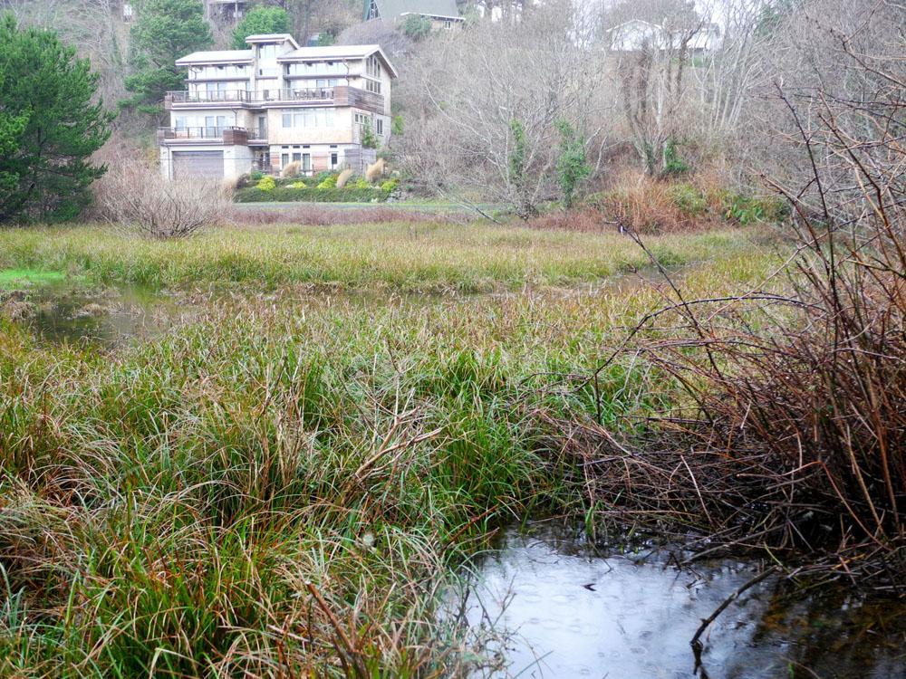
1 February 29, 2016 To: Sarah Absher Senior Planner Tillamook County Department of Community Development From: Richard Hook Chair, Neskowin Citizen Advisory Committee Subject: Application PLNG: Proposal Rock Cove Subdivision The purpose of this letter is to convey the observations and opinion of the Neskowin Citizen Advisory Committee (CAC) with respect to the application for development and subdivision made by Seabreeze Associates LP (Robert Fultz, General Partner). At the last CAC meeting, the CAC voted 36-0 (with one abstention) in opposition to this application. The reasons for our opposition are outlined below. General Observations First, it should be noted that the property subject to this application is almost entirely within the Neskowin Coastal Hazards Overlay Zone. Mr. Fultz, through legal maneuvers, obtained an exception to the Coastal Hazards ordinances approved by the County last year. If the exception had not been granted, this proposed subdivision would not be allowed, and the property would be limited to one lot. The underlying reasons for the Coastal Hazard Zone have not disappeared; the property is still subject to all of the hazards that were outlined in the approval process for the zone. Second, the entire tract occupies an undrained topographic low. Please see photo Seabreeze1, taken from above the southeast corner of the property, and photo Seabreeze2, taken from ground level. Everyone, including Mr. Fultz, agrees that there is a substantial wetland on this property (0.79 acres out of a total 3.26 acres). Despite this fact, Mr. Fultz has chosen to maximize the number of lots in his subdivision proposal, thereby requiring a large amount of fill and a questionable means of mitigating the wetland and dealing with the runoff and drainage. This action is an unnecessary complication that creates many problems, as detailed below. Detailed Observations - Statewide Planning Goal 7 Statewide Planning Goal 7, Areas Subject to Natural Disasters and Hazards, reads: To protect life and property from natural disasters and hazards, developments subject to damage or that could result in loss of life shall not be planned nor located in known areas of natural disasters and hazards without appropriate safeguards. Plans shall be based on an inventory of known areas of natural disaster and hazard. The hazards listed include ocean flooding and erosion. The State planning requirements specify, among other requirements, that: 1. Developments should be keyed to the degree of hazard present; 2. Plans for flood areas should prefer uses that do not require structural protection; 3. Low density and open space uses should be preferred in floodplains There are few locations within the Neskowin Coastal Hazard Zone that are more at risk from coastal erosion and ocean wave action and flooding than the proposed Proposal Rock Cove Subdivision. Longtime residents tell us that before the buildup of the foredune and the placement of riprap, this area, locally known as The Cove, was subject to direct wave action and flooding. Even Mr. Fultz recognizes that this was once an ocean cove, calling his development Proposal Rock Cove. A breach of the riprap and foredune would subject this area to this direct action from the ocean, filled or not. The Neskowin
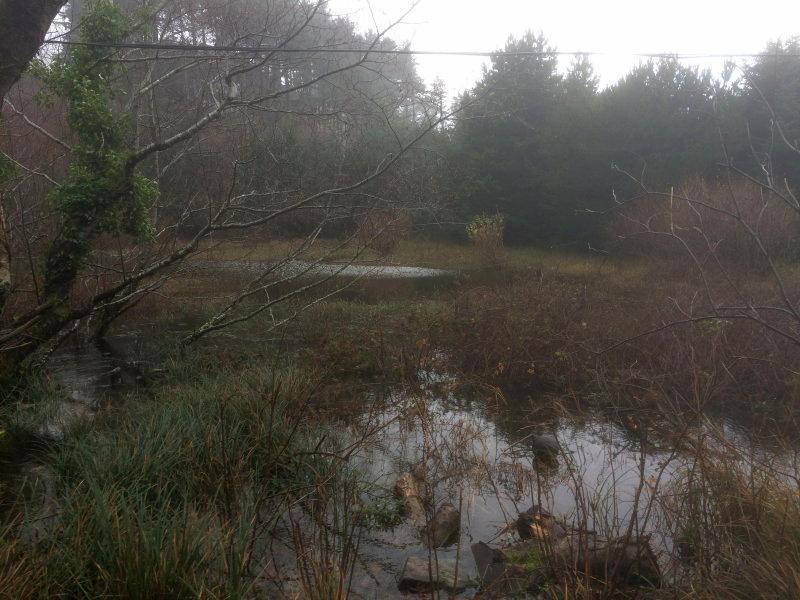
2 Shoreline Assessment, Coastal Engineering Analysis of Existing and Proposed Shoreline Protective Structures (ESA PWA environmental engineers, March 2013) that is included in The Neskowin Coastal Erosion Adaptation Plan (June 2013), states that as waves increase in height, the revetment (i.e. riprap) will experience more damage during storms, leading to greater maintenance costs (page 15); and that the large volumes of overtopping water have contributed to structural failures (page 17). The maintenance of the riprap to the west of this property relies almost entirely on property owners on the beachfront, who may, or may not, choose to incur this sizable and ever increasing cost. The riprap and foredune will have to be maintained for the expected term of occupancy of the new homes in this proposed development to prevent the destruction of these homes by the ocean. Detailed Observations Wetland Issues The Neskowin Community Plan, the Oregon Department of State Lands (DSL), and US Fish and Wildlife all concur that there is a sizable wetland on the property (0.79 acres, per DSL, out of a total 3.26 acres). Please see photo Seabreeze3, taken from north of the property, looking south. Building on the wetland requires approval of the Oregon Department of State Lands (and perhaps US Army Corps of Engineers and US Fish and Wildlife). In a letter sent to Mr. Fultz by DSL, dated December 15, 2015, DSL advised Mr. Fultz that state law establishes a preference for avoidance of wetland impacts. Because measures to avoid and minimize wetland impacts may include reconfiguring parcel layout and size or development design, we recommend that you work with Department staff on appropriate site design before completing the city or county land use approval process. The development proposal Mr. Fultz submitted to the County, contains no indication that he has worked with DSL on an appropriate site design that avoids and minimizes wetland impacts. Further, the submitted application proposes to elevate the wetland areas up to grade with 2900 cubic yards of fill. Filling the wetland requires a Removal-Fill permit issued by DSL. This permit has a 120 day review process, including a Public review. As of February 17, Mr. Fultz has not applied for a Removal-Fill Permit; and thus could not obtain this permit, in the event it was approved, any sooner than the middle of June. Although DSL does not require Mr. Fultz to postpone submission of his application for development to the County until he has obtained an agreement with DSL on an appropriate site design and a Removal- Fill permit, it is obvious that his development plan rests on the assumption that DSL will approve his proposal as submitted. The Tillamook County Land Division Ordinance, Section 070, part (1)(h) requires Evidence that any required State and Federal permits, as applicable, have been obtained or can reasonably be obtained prior to development. No such evidence has been provided in the application. Given the uncertainty that his application for a Removal-Fill Permit will be approved, especially since the proposed subdivision does not avoid and minimize wetland impacts, and given the problems with wetland mitigation, it is inappropriate for Mr. Fultz to submit his application to the County for approval before these issues are resolved. Wetland mitigation is to be accomplished using two 5-foot-square catch basins connected to drainage lines that feed into two drywells separated by a 149 foot long, 3 foot diameter infiltration pipe on an adjacent Fultz-owned property. The seaward drywell is located within 10 to 15 feet of the top of the riprap revetment. The drywells and infiltration pipe will be only a few feet (at most) above the water table and it is difficult to see how these wells will accommodate the runoff. Sheet 4 of four shows this drainage plan, with the note: pipe sizes assumed. Drainage calculations to be prepared as part of final design. Thus, even the engineer does not know if the proposed plan will work at this point. It should be further noted that because the Cove is surrounded by higher elevations in every direction, the area
3 the area to be served by the drainage system is not just the 3.26 acres of the proposed development site but the surrounding 8 acres as well The drainage plan does not document the suitability of the soils nor the depth of the water table in the area of the proposed dry wells. There is a significant likelihood that the saturated soils in the dry well area could: Weaken the riprap Damage the adjacent road Result in standing water that damages the road and adjacent properties It seems that, at a minimum, the applicant should be required to demonstrate, by means of a report from a licensed engineer, the feasibility of the wetland mitigation plan, without creating the problems identified above. Further, the subdivision proposal does not contain a plan or provision for the access to and maintenance of the drainage system. Because the subdivision proposal includes an untested mitigation scheme, DSL could require the Applicant to monitor the drainage system for 5 years, and after that time the monitoring requirement could be extended if standards of the permit are not met. The applicant must also put up a financial instrument that DSL holds until the monitoring is complete. DSL also requires that the mitigation site must also have permanent protection. Furthermore, per the Tillamook County Land Division Ordinance, Section 070, part (1)(f), the applicant must also provide that all proposed private common areas and improvements if any, are identified on the preliminary plat and maintenance of such areas is assured through an appropriate legal instrument. No such assurance through a legal instrument has been provided. According to Goal 7 of the Tillamook County Comprehensive Plan, Weak Bearing Soils are compressible soils that undergo a significant decrease in volume when subject to loading. Such soils commonly contain organic matter, such as peat, that release water under pressure. Compressible soils are associated with marshland (wetlands), tidal flats, estuaries, lake margins, and interdune areas, and are most likely present on this property. As acknowledged in the geologic report by R. Warren Krager that is included in the application, subsurface explorations were limited to hand-auger borings that terminated in near surface beach and dune sands. Construction on compressible soils can result in differential settling of a wide variety of structures including homes, roads, and drainage lines. According to Goal 7, proper engineering investigations should precede all medium to large construction in regions of possible compressible soils. Also, protective measures shall be taken to insure that the cumulative effect of a proposed development or fill, when combined with all other development or previous placement of fill, will not increase the water surface elevation above a specified level. In his application, Mr. Fultz has not provided any proper engineering investigations nor has he demonstrated that the cumulative effect of the proposed development will not increase the water surface elevation above a specified level. Tillamook County Land Division Ordinance, Section 060, part (1)(c)vii also states that the County may require that information be provided on the nature of the soil. This information also has not been provided.
4 Detailed Observations Road Access The sole access to the property includes an 800-foot-long section of road with a 20-foot-wide easement (Nescove Drive) that is immediately adjacent to the top of the riprap revetment and experiences overwash during storms during high water periods (this road section is shown in the upper left-hand corner of Sheet 1 of 4 of the Proposal Rock Cove Subdivision Preliminary Plat provided by Mr. Fultz.). Per the Tillamook County Land Division Ordinance, Section 070, part (1)(c): Access to individual lots, and public improvements necessary to serve the development, including but not limited to water, sewer and streets, shall conform to the standards in Sections 150 and 160 of this ordinance. Section 150(3) requires that Improvements may be required by the Public Works Department on streets serving, but not within the boundaries of, the Subdivision or through the Partition of a parcel with a buildout potential of 5 or more parcels Section 160(3)(a) requires a minimum right-of-way of 30 feet for local roadways. According to Section 160(7), Whenever existing streets adjacent to or within a tract are of inadequate width, additional right-of-way and surfacing shall be provided by the applicant as part of the Subdivision or Partition. Widening the road will require the unlikely concurrence of the property owners. There are also problems with the additional traffic on Nescove Drive. Section 160(2)(b) requires that an Average Daily Traffic (ADT) for design is to be determined based on the anticipated future usage of the roadway based on maximum density allowed by the zoning. There is no indication that the applicant has made this determination. The oceanfront access road receives heavy pedestrian traffic during the summer and additional vehicle traffic, particularly during construction periods, will place pedestrians at risk. Passage of emergency vehicles could also be impaired by increased traffic. This potential impairment is a significant concern as the ocean front road is the only means of ingress into or egress out of the site of the proposed development. Furthermore, the heavy truck traffic during construction, especially that associated with mitigating the wetland, will damage the road. The subdivision proposal does not contain a provision for compensation for road damage. Roads in this area are maintained by the South Beach Road Association, a group of property owners that share easement rights to the roads. Mr. Fultz s record of contributing money to road maintenance is poor. In recent years, he has declined to pay his road assessment fees to the Road Association. We strongly recommend that the County, given these facts, rigorously enforce the provisions of Section 140 of the Tillamook County Land Division Ordinance. Given these uncertainties, it is our opinion that the road is inadequate for this proposed plan of development. Conclusion In summary, the CAC opposes this application. If, against the opposition of the community and all of the inadequacies of the submitted proposal for development outlined above, the County decides to approve the plan, we ask that the County not approve any of the Uses Permitted Conditionally, per the Tillamook County Land Use Ordinance Section 3.322(3). This area is within the coastal hazard zone, even though an exemption has been permitted for subdivision, and all the reasons for minimizing density still pertain. We submit this letter and the following photographs to the Tillamook County Department of Community Development for consideration by the Tillamook County Planning Commission.
5
Guide to Preliminary Plans
 Guide to Preliminary Plans Introduction The Douglas County is committed to providing open, transparent application processes to the public. This Guide is provided to assist anyone interested in the procedures
Guide to Combined Preliminary and Final Plats
 Guide to Combined Preliminary and Final Plats Introduction The Douglas County is committed to providing open, transparent application processes to the public. This Guide is provided to assist anyone interested
WASCO COUNTY PRELIMINARY SUBDIVISION APPLICATION
 WASCO COUNTY PRELIMINARY SUBDIVISION APPLICATION DETAILED SPECIFIC WRITTEN REQUEST File Number: SDV- Number of Proposed Lots & their Dimensions: PRELIMINARY SUBDIVISION PLAN REQUIREMENTS The approval of
CHECKLIST FOR DEVELOPMENT REVIEW
 CHECKLIST FOR DEVELOPMENT REVIEW Petitions and related documents and plans for land development or other proposals regulated by Title 16 of the Municipal Code (Development Ordinance) and Title 17 of the
DEVELOPMENT PLAN ORDINANCE
 DEVELOPMENT PLAN ORDINANCE CITY OF GLASGOW Ordinance No. 2026 SECTION A. Section 1. INTENT AND PURPOSE The purpose of this Ordinance is to establish and define development plans, which may be utilized
Open Space Model Ordinance
 Open Space Model Ordinance Section I. Background Open space development has numerous environmental and community benefits, including: 1) Reduces the impervious cover in a development. Impervious cover
Town of Lisbon, Maine SUBDIVISION REVIEW APPLICATION
 Date Received: Fee Paid (amount): Applicant: Town of Lisbon, Maine SUBDIVISION REVIEW APPLICATION Subdivision Name/Title: This application must be received at the Town Office by close of business on the
BOUNDARY LINE ADJUSTMENT
 DEPARTMENT OF COMMUNITY DEVELOPMENT 621 Sheridan Street, Port Townsend, WA 98368 Tel: 360.379.4450 Fax: 360.379.4451 Web: www.co.jefferson.wa.us/communitydevelopment E-mail: dcd@co.jefferson.wa.us BOUNDARY
Special Use Permit - Planned Unit Development Checklist. Property Address:
 Special Use Permit - Planned Unit Development Checklist Special Use Permit Number. Parcel Code/s #28-11- - - Property Address: Applicant: ARTICLE VIII Ordinance Reference - Section 8.1.2 Permit Procedures:
Chapter 100 Planned Unit Development in Corvallis Urban Fringe
 100.100 Scope and Purpose. Chapter 100 Planned Unit Development in Corvallis Urban Fringe (1) All applications for land divisions in the Urban Residential (UR) and Flood Plain Agriculture (FPA) zones within
LAND USE APPLICATION
 Lincoln County Department of Planning & Development 210 SW 2nd Street, Newport, OR 97365 Phone (541) 265-4192 Fax (541) 265-6945 LAND USE APPLICATION TO BE COMPLETED BY STAFF Conditional Use Non-Conforming
SUBDIVISION APPLICATION CHECKLIST SKETCH PLAN PRELIMINARY PLAT FINAL PLAT
 RECEIVED STAMP SUBDIVISION APPLICATION CHECKLIST SKETCH PLAN PRELIMINARY PLAT FINAL PLAT A checklist of background information and submission requirements for processing of a sketch plan, preliminary plat
SECTION 16. "PUD" PLANNED UNIT DEVELOPMENT OVERLAY DISTRICT
 SECTION 6. "PUD" PLANNED UNIT DEVELOPMENT OVERLAY DISTRICT Subsection. Purpose. This district is established to achieve the coordinated integration of land parcels and large commercial and retail establishments
Guide to Minor Developments
 Guide to Minor Developments Introduction The Douglas County (DCD) is committed to providing open, transparent application processes to the public. This Guide is provided to assist anyone interested in
-MENDOCINO COUNTY PLANNING AND BUILDING SERVICES- DIVISION OF LAND REGULATIONS TITLE 17
 ARTICLE VI -- GENERAL REGULATIONS AND PROVISIONS Sec. 17-50. Sec. 17-51 General Plan. Sec. 17-52 Lot and Block Design and Configuration. Sec. 17-53 Lot Access. Sec. 17-54 Private Roads. Sec. 17-55 Water
DOUGLAS COUNTY SUBDIVISION RESOLUTION Article 4 Preliminary Plan 10/13/2015
 ARTICLE 4 PRELIMINARY PLAN 401 Intent An in-depth analysis of the proposed subdivision, including a review of the design considering the ability to obtain water and sanitation, identified geologic hazards,
PRELIMINARY PLAT CHECK LIST
 PRELIMINARY PLAT CHECK LIST Name of Proposed Subdivision: The following items must be included with the initial submittal of a Preliminary Plat: Application, filled out completely Project Narrative Pre-application
ELK RAPIDS TOWNSHIP ANTRIM COUNTY, MICHIGAN ORDINANCE NO
 ELK RAPIDS TOWNSHIP ANTRIM COUNTY, MICHIGAN ORDINANCE NO. 3-2011 AN ORDINANCE TO REPLACE THE SUBDIVISION CONTROL ORDINANCE WITH A NEW SUBDIVISION DEVELOPMENT ORDINANCE, IN ACCORD WITH THE LAND DIVISION
Applicant: Address: Fee Owner: Address: Property Location (Address and Complete (long) Legal Description: Detailed Reason for Request:
 Legal Description: Detailed Reason for Request:") Date Received: Received By: Permit #: LAND USE APPLICATION Comprehensive Plan Zoning District Amend Zoning Text Amend Variance*(see below) Zoning Appeal Conditional Use Permit (C.U.P.) Flood Plain C.U.P.
Date Received: Received By: Permit #: LAND USE APPLICATION Comprehensive Plan Zoning District Amend Zoning Text Amend Variance*(see below) Zoning Appeal Conditional Use Permit (C.U.P.) Flood Plain C.U.P.
Floodplain Development Land Use Review
 PUBLIC WORKS - COMMUNITY DEVELOPMENT 333 Broadalbin Street SW, PO Box 490, Albany, Oregon 97321-0144 BUILDING 541-917-7553 PLANNING 541-917-7550 Floodplain Development Land Use Review Application Information
Preliminary Subdivision Application (Minor) (Three (3) lots or less)
 (Three (3) lots or less)") Gunnison City Offices www.gunnisoncity.org 38 West Center Gunnison, Utah 84634 (435) 528 7969 Date of Application: Preliminary Subdivision Application (Minor) (Three (3) lots or less) APPLICANT INFORMATION
Gunnison City Offices www.gunnisoncity.org 38 West Center Gunnison, Utah 84634 (435) 528 7969 Date of Application: Preliminary Subdivision Application (Minor) (Three (3) lots or less) APPLICANT INFORMATION
Application for Preliminary Plat Checklist
 Application for Preliminary Plat Checklist Note: No portion of an existing parcel may be sold or transferred to another party without first legally subdividing the property according to the City of Richmond
9. REZONING NO Vicinity of the northwest corner of 143 rd Street and Metcalf Avenue
 9. REZONING NO. 2002-15 Vicinity of the northwest corner of 143 rd Street and Metcalf Avenue 1. APPLICANT: Andrew Schlagel is the applicant for this request. 2. REQUESTED ACTION: The applicant is requesting
DIVISION 9. PLANNED URBAN DEVELOPMENT CLASSIFICATION BY SPECIAL USE FOR ALL ZONING DISTRICTS Sec Statement Of Purpose: (a) Planned
 Planned") DIVISION 9. PLANNED URBAN DEVELOPMENT CLASSIFICATION BY SPECIAL USE FOR ALL ZONING DISTRICTS Sec. 12-169. Statement Of Purpose: (a) Planned developments are such substantially different character from
DIVISION 9. PLANNED URBAN DEVELOPMENT CLASSIFICATION BY SPECIAL USE FOR ALL ZONING DISTRICTS Sec. 12-169. Statement Of Purpose: (a) Planned developments are such substantially different character from
SECTION 4: PRELIMINARY PLAT
 SECTION 4: PRELIMINARY PLAT After the completion of the sketch plan process, if submitted, the owner or developer shall file with the City an application for preliminary plat. The preliminary plat stage
BRIDGETON SUBDIVISION APPLICATION CHECKLIST
 APPLICATION NAME AND # CHECKLIST COMPLETED BY: DATE: Signature and printed name BRIDGETON SUBDIVISION APPLICATION CHECKLIST TO SUBDIVISION APPLICANTS: The attached checklist is to assist you in the submission
A. Preserve natural resources as identified in the Comprehensive Plan.
 1370.08 Conservation Residential Overlay District. Subd. 1 Findings. The City finds that the lands and resources within the Conservation Residential Overlay District are a unique and valuable resource
ARTICLE 23 CONDOMINIUM STANDARDS
 ARTICLE 23 CONDOMINIUM STANDARDS Section 23.01 Intent. The intent of this Article is to provide regulatory standards for condominiums and site condominiums similar to those required for projects developed
Town of Bristol Rhode Island
 Town of Bristol Rhode Island Subdivision & Development Review Regulations Adopted by the Planning Board September 27, 1995 (March 2017) Formatted: Highlight Formatted: Font: 12 pt Table of Contents TABLE
Town of Shelburne, Vermont
 Town of Shelburne, Vermont CHARTERED 1763 P.O. BOX 88 5420 SHELBURNE ROAD SHELBURNE, VT 05482 www.shelburnevt.org 802-985-5118 * * Also available in alternate formats in accordance with the Americans With
Guide to Replats. Step 1. Step 2. Step 3. Step 4. Step 5. Step 6. Step 7. Step 8. Step 9. Step 10
 Guide to Replats Introduction Douglas County is committed to providing open, transparent application processes to the public. This Guide is provided to assist anyone interested in the procedures and expectations
APPLICATION FOR SUBDIVISION APPROVAL OF A SKETCH PLAN with checklist
 Prior to filing any application for SUBDIVISION approval, the applicant shall request in writing that the zoning administrator schedule a pre-submission conference. APPLICATION TO THE PLANNING BOARD TOWN
Waseca County Planning and Zoning Office
 Waseca County Planning and Zoning Office 300 North State Street Waseca, Minnesota 56093 Phone: 507-835-0650 Fax: 507-837-5310 Form no. PZ 081009 Web Site: www.co.waseca.mn.us FEES: 1) CUP FEE- $400.00
ALBA BEACH SUBDIVISION, RESUBDIVISION OF LOT 17
 ALBA BEACH SUBDIVISION, RESUBDIVISION OF LOT 17 Engineering Comments: FINAL PLAT COMMENTS (should be addressed prior to submitting the FINAL PLAT for acceptance and signature by the City Engineer): A.
SECTION 6 - APPROVAL OF PLATS. Whenever any subdivision of land is proposed, and before any permit for the
 SECTION 6 - APPROVAL OF PLATS 6-1 APPROVAL REQUIRED BEFORE SALE Whenever any subdivision of land is proposed, and before any permit for the erection of a structure shall be granted, the subdivider or his
Tentative Map Application Review Procedures
 FOR REFERENCE ONLY This page is not part of the application. Tentative Map Application Review Procedures The tentative map process in Churchill County is designed to provide a mechanism in order to divide
13-2 SUBDIVISION PLANS AND PLATS REQUIRED EXCEPTIONS Subdivision Plats Required To be Recorded
 ARTICLE XIII SUBDIVISIONS 13-1 INTENT AND PURPOSE 13-1-1 Intent: It is the intent of the County Commission through the adoption of this Article to more fully avail itself of the power granted under 17-27-601
Preliminary Subdivision Application (Major) (Four (4) lots or more)
 (Four (4) lots or more)") Gunnison City Offices www.gunnisoncity.org 38 West Center Gunnison, Utah 84634 (435) 528 7969 Date of Application: Preliminary Subdivision Application (Major) (Four (4) lots or more) APPLICANT INFORMATION
Gunnison City Offices www.gunnisoncity.org 38 West Center Gunnison, Utah 84634 (435) 528 7969 Date of Application: Preliminary Subdivision Application (Major) (Four (4) lots or more) APPLICANT INFORMATION
ARTICLE 24 SITE PLAN REVIEW
 ARTICLE 24 SITE PLAN REVIEW 24.1 PURPOSE: The intent of these Ordinance provisions is to provide for consultation and cooperation between the land developer and the Township Planning Commission in order
THE COUNTY BOARD OF SUPERVISORS OF THE COUNTY OF DOUGLAS DOES ORDAIN AS FOLLOWS:
 8.1 SUBDIVISION CONTROL ORDINANCE THE COUNTY BOARD OF SUPERVISORS OF THE COUNTY OF DOUGLAS DOES ORDAIN AS FOLLOWS: SECTION I. GENERAL INTERPRETATION This ordinance shall not repeal, impair or modify private
ARTICLE FIVE FINAL DRAFT
 ARTICLE FIVE 021218 FINAL DRAFT Sec. 503.6 Open Space Preservation Option Open Space Preservation Option Open Space Preservation developments may be approved in the AR, R-1, R-2 and R-3 zoning districts,
FIRE ISLAND INLET TO MORICHES INLET FIRE ISLAND STABILIZATION PROJECT TECHNICAL SUPPORT DOCUMENT
 FIRE ISLAND INLET TO MORICHES INLET FIRE ISLAND STABILIZATION PROJECT TECHNICAL SUPPORT DOCUMENT EVALUATION OF A STABILIZATION PLAN FOR STORM DAMAGE REDUCTION COST APPENDIX U.S. Army Corps of Engineers
CITY OF GROVER BEACH COMMUNITY DEVELOPMENT DEPARTMENT Tentative Map Checklist
 CITY OF GROVER BEACH COMMUNITY DEVELOPMENT DEPARTMENT Tentative Map Checklist The following list includes all of the items you must submit for a complete application. Some specific types of information
Township of Collier 2418 Hilltop Road Presto, PA 15142
 Township of Collier 2418 Hilltop Road Presto, PA 15142 Fees: Major: 2 checks $600 + $50 per lot & $1700 Escrow) APPLICATION FOR SUBDIVISION major FINAL only Plans must be folded Rolled plans will not be
CITY OF FORT COLLINS NATURAL AREAS AND CONSERVED LANDS EASEMENT POLICY
 CITY OF FORT COLLINS NATURAL AREAS AND CONSERVED LANDS EASEMENT POLICY Adopted January 3, 2012 PURPOSE: The purpose of the policy statement is to clarify the policies and procedures of the City of Fort
BYRON TOWNSHIP ZONING APPLICATION
 BYRON TOWNSHIP ZONING APPLICATION Phone: (616) 878-9104 * Fax: (616) 878-3980 * Website: www.byrontownship.org This application will not be accepted if incomplete. APPLICATION FOR & REQUIRED COPIES Private
SUBDIVISION REGULATIONS OF THE CITY OF DERBY, KANSAS
 SUBDIVISION REGULATIONS OF THE CITY OF DERBY, KANSAS ARTICLE 1. TITLE, PURPOSE, AUTHORITY, JURISDICTION, APPLICABILITY AND EXEMPTIONS 100 TITLE. These regulations shall be known and may be cited as the
HERON LANDING SUBDIVISION
 HERON LANDING SUBDIVISION Engineering Comments: Per FEMA guidelines, any development greater than 5 acres in size or subdivision 50 lots in size, requires a flood study. Width of drainage easement to be
Initial Subdivision Applications Shall Include the Following:
 Initial Subdivision Applications Shall Include the Following: 1) Subdivision Application Form: completely filled out (12 copies) 2) Plat: The Plat must adhere to the requirements set forth in the Town
MAJOR SUBDIVISION PRELIMINARY PLAT CHECKLIST
 TOWNSHIP OF EGG HARBOR PLANNING BOARD/ZONING BOARD OF ADJUSTMENT 3515 BARGAINTOWN ROAD EGG HARBOR TOWNSHIP, NJ 08234 MAJOR SUBDIVISION PRELIMINARY PLAT CHECKLIST The following checklist is designed to
Town of Middleborough Conservation Commission 2014 Policy
 Approved February 20, 2014 Town of Middleborough Conservation Commission 2014 Policy The Wetland Protection Act under M.G.L. c. 131, sec. 40 and regulations 310 CMR 10.02(1)(a-f) & 310 CMR 10.02 (2)(a)
SECTION 10: FLOOD HAZARD EVALUATION 10-1
 10) SECTION 10: FLOOD HAZARD EVALUATION A. General. Land subject to being flooded by a Flood of 100-Year Frequency as defined by Title 76, Chapter 5, MCA, or land subject to flooding pursuant to these
ARTICLE 15 - PLANNED UNIT DEVELOPMENT
 Section 15.1 - Intent. ARTICLE 15 - PLANNED UNIT DEVELOPMENT A PUD, or Planned Unit Development, is not a District per se, but rather a set of standards that may be applied to a development type. The Planned
WESTON COUNTY FINAL PLAT APPLICATION
 WESTON COUNTY FINAL PLAT APPLICATION Property Owner: Mailing Address of owner: Telephone Number(s) of owner: Property Owner: Mailing Address of owner: Telephone Number(s) of owner: (If subdivider/applicant
DEPARTMENT OF THE ARMY OFFICE OF THE CHIEF OF ENGINEERS WASHINGTON, D.C
 DEPARTMENT OF THE ARMY OFFICE OF THE CHIEF OF ENGINEERS WASHINGTON, D.C. 20314-1000 REPLY TO ATTENTION OF: CECW-PM (10-1-7a) THE SECRETARY OF THE ARMY 1. I submit for transmission to Congress my report
Cover Letter with Narrative Statement
 Cover Letter with Narrative Statement March 31, 2017 rev July 27, 2017 RE: Rushton Pointe Residential Planned Unit Development Application for Public Hearing for RPUD Rezone PL2015 000 0306 Mr. Eric Johnson,
COMMUNITY DEVELOPMENT DEPARTMENT 333 Broadalbin Street SW, P.O. Box 490 Albany, OR 97321
 COMMUNITY DEVELOPMENT DEPARTMENT 333 Broadalbin Street SW, P.O. Box 490 Albany, OR 97321 Ph: 541-917-7550 Fax: 541-917-7598 www.cityofalbany.net STAFF REPORT Application for Site Plan Review SP-07-18 and
State, County, or Municipal Agency or instrumentality thereof, applying for authorization
 Application for Project Authorization Under the New Jersey Register of Historic Places Act NJ Department of Environmental Protection Natural & Historic Resources Historic Preservation Office Date September
TILLAMOOK COUNTY LAND DIVISION ORDINANCE TABLE OF CONTENTS SECTION NUMBER & TITLE
 TILLAMOOK COUNTY LAND DIVISION ORDINANCE TABLE OF CONTENTS SECTION NUMBER & TITLE PAGE INTRODUCTION 1 Purpose...3 2 Definitions...4 3 Scope of Regulations...8 4 Pre-Application Meeting; Background Information...8
PLANNED UNIT DEVELOPMENTS (Ordinance No.: 3036, 12/3/07; Repealed & Replaced by Ordinance No.: 4166, 10/15/12)
") 159.62 PLANNED UNIT DEVELOPMENTS (Ordinance No.: 3036, 12/3/07; Repealed & Replaced by Ordinance No.: 4166, 10/15/12) A. PURPOSE 1. General. The Planned Unit Development (PUD) approach provides the flexibility
159.62 PLANNED UNIT DEVELOPMENTS (Ordinance No.: 3036, 12/3/07; Repealed & Replaced by Ordinance No.: 4166, 10/15/12) A. PURPOSE 1. General. The Planned Unit Development (PUD) approach provides the flexibility
I. Requirements for All Applications. C D W
 108-16.1. Application checklists. Checklist for Required Submissions to the Planning Board or Zoning Board of Adjustment of Monroe Township All required submissions are to be made to the Administrative
TOOELE COUNTY LAND USE ORDINANCE CHAPTER 31 Page 1
 CHAPTER 31 PLANNED COMMUNITY ZONE (P-C) Section 31-1 Definitions. 31-2 Purpose. 31-3 Land use districts. 31-4 P-C zone area minimum requirements. 31-5 Permitted uses. 31-6 Conditional uses. 31-7 Planning
Multiple Use Forest District (MUF)
") This district is defined as Multiple Use Forest District with a minimum lot size of 20 acres. 11.15.2162 Purposes The purposes of the Multiple Use Forest District are to conserve and encourage the use
This district is defined as Multiple Use Forest District with a minimum lot size of 20 acres. 11.15.2162 Purposes The purposes of the Multiple Use Forest District are to conserve and encourage the use
Umatilla County Department of Land Use Planning
 Umatilla County Department of Land Use Planning 216 SE 4 th ST, Pendleton, OR 97801, (541) 278-6252 Property Line Adjustment, Type V Application & Information Packet PROCESSING THE APPLICATION The application
Project File #: VA Project Name: Beauperthuy Variance Parcel Nos.: , , , ,
 COMMISSIONERS: DARRYL GLENN (PRESIDENT) MARK WALLER (PRESIDENT PRO TEMPORE) STAN VANDERWERF LONGINOS GONZALEZ PEGGY LITTLETON PLANNING AND COMMUNITY DEVELOPMENT DEPARTMENT CRAIG DOSSEY, EXECUTIVE DIRECTOR
APPENDIX B. SUBMISSION REQUIREMENTS
 Master Major Site Minor Site Landscape Section B.1 Table of /Plat Requirements Proposed or approved name of development, project, subdivision, and/or phase. Location, including township, county, and state.
ARTICLE 5 GENERAL REQUIREMENTS
 5.1 SUITABILITY OF THE LAND ARTICLE 5 GENERAL REQUIREMENTS 5.1.1 Land subject to flooding, improper drainage or erosion, and land deemed to be unsuitable for development due to steep slope, unsuitable
CHAPTER 22 SUBDIVISION AND LAND DEVELOPMENT
 CHAPTER 22 SUBDIVISION AND LAND DEVELOPMENT 22-101. Title 22-102. Legislative Intent Part 1 General Provisions 22-201. Development Permits Part 2 Administration 22-301. Fee Schedule Part 3 Fee Schedule
Review of Land Divisions in Open Space and Residential Zones 660
 Title 33, Planning and Zoning Chapter 33.660 5/24/18 Review of Land Divisions in Open Space and Residential Zones 33.660 Review of Land Divisions in Open Space and Residential Zones 660 Sections: General
Reading Plats and the Complexities of Antiquated Subdivisions Presented by: David W. Depew, PhD, AICP, LEED AP Morris-Depew Associates, Inc.
 Presented by: David W. Depew, PhD, AICP, LEED AP Morris-Depew Associates, Inc. Introduction Plat is a term for a survey of a piece of land to identify boundaries, easements, flood zones, roadway, and access
E L M E R B O R O U G H L A N D U S E B O A R D APPLICATION COVER SHEET (to be completed for all applications and appeals)
") E L M E R B O R O U G H L A N D U S E B O A R D APPLICATION COVER SHEET (to be completed for all applications and appeals) 1. Name(s): 2. Address: 3. Telephone Number(s): 4. E-mail: 5. Owner Name(s) (if
E L M E R B O R O U G H L A N D U S E B O A R D APPLICATION COVER SHEET (to be completed for all applications and appeals) 1. Name(s): 2. Address: 3. Telephone Number(s): 4. E-mail: 5. Owner Name(s) (if
SUBMITTAL REQUIREMENTS: The number indicates the number of copies for submittal (if applicable).
.") Office Use Only Preliminary Long Plat Long Subdivision Applicant Checklist PLANNING, COMMUNITY, & ECONOMIC DEVELOPMENT DEPARTMENT FINAL LONG PLAT LONG SUBDIVISION CHECKLIST Mailing Address: P.O. Box 547,
Office Use Only Preliminary Long Plat Long Subdivision Applicant Checklist PLANNING, COMMUNITY, & ECONOMIC DEVELOPMENT DEPARTMENT FINAL LONG PLAT LONG SUBDIVISION CHECKLIST Mailing Address: P.O. Box 547,
Site Plan Application
 Site Plan Application City of St. Pete Beach Community Development Department 155 Corey Avenue St. Pete Beach, Florida 33706 (727) 367-2735 www.stpetebeach.org Case Number: PROPERTY OWNER: Name: Address:
APPLICATION PROCEDURE
 ANTRIM PLANNING BOARD P. O. Box 517 Antrim, New Hampshire 03440 Phone: 603-588-6785 FAX: 603-588-2969 APPLICATION FORM AND CHECKLIST FOR MINOR OR MAJOR SITE PLAN REVIEW File Date Received By APPLICATION
PLANNED UNIT DEVELOPMENT & SUBDIVISION STAFF REPORT Date: April 18, 2019
 PLANNED UNIT DEVELOPMENT & SUBDIVISION STAFF REPORT Date: April 18, 2019 DEVELOPMENT NAME SUBDIVISION NAME Springhill Village Subdivision Springhill Village Subdivision LOCATION 4350, 4354, 4356, 4358,
APPLICATION REVIEW CHECKLISTS
 APPLICATION REVIEW CHECKLISTS The following must be submitted with and are part of each application. No application is complete until all required documentation has been submitted to the Community Development
1105 SUBDIVISIONS, PARTITIONS, REPLATS, CONDOMINIUM PLATS, AND VACATIONS OF RECORDED PLATS
 1105 SUBDIVISIONS, PARTITIONS, REPLATS, CONDOMINIUM PLATS, AND VACATIONS OF RECORDED PLATS 1105.01 PURPOSE AND APPLICABILITY Section 1105 is adopted to provide standards, criteria, and procedures under
SUBMITTAL REQUIREMENTS: The number indicates the number of copies for submittal (if applicable).
.") Office Use Only Preliminary Long Plat Long Subdivision Applicant Checklist PLANNING, COMMUNITY, & ECONOMIC DEVELOPMENT DEPARTMENT PRELIMINARY LONG PLAT LONG SUBDIVISION CHECKLIST Mailing Address: P.O.
Office Use Only Preliminary Long Plat Long Subdivision Applicant Checklist PLANNING, COMMUNITY, & ECONOMIC DEVELOPMENT DEPARTMENT PRELIMINARY LONG PLAT LONG SUBDIVISION CHECKLIST Mailing Address: P.O.
Chapter Plat Design (LMC)
") Chapter 18.14 Plat Design (LMC) Sections: 18.14.010 Lot width 18.14.020 Right-of-way requirements 18.14.030 Pipe stem lots 18.14.040 Division resulting in minimum lot sizes 18.14.050 Flood prone and bad
Chapter 18.14 Plat Design (LMC) Sections: 18.14.010 Lot width 18.14.020 Right-of-way requirements 18.14.030 Pipe stem lots 18.14.040 Division resulting in minimum lot sizes 18.14.050 Flood prone and bad
Some Social and Policy Implications of Shore Erosion. James G. Titus U.S. Environmental Protection Agency
 Some Social and Policy Implications of Shore Erosion James G. Titus U.S. Environmental Protection Agency Four copyrighted photos included in briefing as fair use Deleted because duplication may violate
Town of Falmouth s Four Step Design Process for Subdivisions in the Resource Conservation Zoning Overlay District
 Town of Falmouth s Four Step Design Process for Subdivisions in the Resource Conservation Zoning Overlay District All subdivisions shall be designed in accordance with the following four-step process.
DRAFT FOR PUBLIC HEARING (rev. March, 2016)
") Chapter 200. ZONING Article VI. Conservation/Cluster Subdivisions 200-45. Intent and Purpose These provisions are intended to: A. Guide the future growth and development of the community consistent with
Chapter 200. ZONING Article VI. Conservation/Cluster Subdivisions 200-45. Intent and Purpose These provisions are intended to: A. Guide the future growth and development of the community consistent with
FINAL DRAFT 10/23/06 ARTICLE VI
 FINAL DRAFT 10/23/06 ARTICLE VI 185-41.1. Planned Residential Development A. Purpose and Intent. The purposes of the Planned Residential Development (PRD) bylaw are to maintain the rural character of Dover,
MINOR BOUNDARY LINE ADJUSTMENT PROCESS GUIDE
 MINOR BOUNDARY LINE ADJUSTMENT PROCESS GUIDE Clear Creek County Planning Department P.O. Box 2000 Georgetown, Colorado 80444 (303) 679-2436 phone (303) 569-1103 fax 1 PURPOSE To establish criteria and
KEIZER COMMUNITY DEVELOPMENT DEPARTMENT STAFF RECOMMENDATION Subdivision Case No
 KEIZER COMMUNITY DEVELOPMENT DEPARTMENT STAFF RECOMMENDATION Subdivision Case No. 2014-14 TO: FROM: Cynthia Domas, Keizer Hearings Officer Sam Litke, Senior Planner SUBJECT: Subdivision Case No. 2014-14
Group Sewer Only** 80 Ft Frontage* 20,000 Sq. Ft. (.46 acre) Minimum** 120 Ft Frontage* 20,000 Sq. Ft. (.46acre) Minimum** 150 Ft Frontage*
 Minimum** 120 Ft Frontage* 20,000 Sq. Ft. (.46acre) Minimum** 150 Ft Frontage*") Residential Lots Minimum Chart The minimum lot size of any minor subdivision where there is no public sewers shall be as shown below or as required by township zoning and/or the Tuscarawas General Health
Residential Lots Minimum Chart The minimum lot size of any minor subdivision where there is no public sewers shall be as shown below or as required by township zoning and/or the Tuscarawas General Health
City of East Orange. Department of Policy, Planning and Development LAND USE APPLICATION & SITE PLAN REVIEW CHECKLIST
 Department of Policy, Planning and Development LAND USE APPLICATION & SITE PLAN REVIEW CHECKLIST COMPLETE: Applicant Information: Type of Proposal: OFFICE USE ONLY: New Residential Case #: Date: New Accessory
FRESHWATER WETLANDS PROTECTION IN NEW JERSEY Tools for Municipal Action
 FRESHWATER WETLANDS PROTECTION IN NEW JERSEY Tools for Municipal Action The Freshwater Wetlands Protection Act INTENT OF FRESHWATER WETLANDS LAW The New Jersey legislature passed the Freshwater Wetlands
City of Sanibel. Planning Department STAFF REPORT
 City of Sanibel Planning Department STAFF REPORT Planning Commission Meeting: July 23, 2013 Planning Commission Agenda Item: No 7b. Application Number: 13-7438DP Applicant Name: Attorney Beverly Grady
KEIZER COMMUNITY DEVELOPMENT DEPARTMENT STAFF RECOMMENDATION Subdivision Case No
 KEIZER COMMUNITY DEVELOPMENT DEPARTMENT STAFF RECOMMENDATION Subdivision Case No. 2014-01 TO: FROM: Cynthia Domas, Keizer Hearings Officer Sam Litke, Senior Planner SUBJECT: Subdivision Case No. 2014-01
Article 7: Residential Land Use and Development Requirements
 Article 7: Residential Land Use and Section 701: Statement of Intent (A) (B) (C) The intent of Article 7 is to develop certain land use and development requirements for the residential uses within Cumru
CITY OF CORNING TENTATIVE MAPS
 CITY OF CORNING TENTATIVE MAPS APPLICANT S GUIDE TO PROCEDURES WHAT IS A TENTATIVE MAP? A division of land for the purpose of sale, lease, or finance requires submittal of a map for City approval showing
ARTICLE 7: PLOT PLANS AND SITE PLAN REQUIREMENTS AND REVIEW
 ARTICLE 7: PLOT PLANS AND SITE PLAN REQUIREMENTS AND REVIEW Section 7.0 - Purpose The purpose of this article is to specify the documents and/or drawings required for a Site Plan Review or a Plot Plan
610 LAND DIVISIONS AND PROPERTY LINE ADJUSTMENTS OUTSIDE A UGB
 ARTICLE VI: LAND DIVISIONS AND PROPERTY LINE ADJUSTMENTS VI-21 610 LAND DIVISIONS AND PROPERTY LINE ADJUSTMENTS OUTSIDE A UGB 610-1 Property Line Adjustments (Property Line Relocation) A property line
ARTICLE V PRELIMINARY PLAN SUBMISSION
 ARTICLE V PRELIMINARY PLAN SUBMISSION 501. Plan Requirements a. On or before the 25 th day of the month prior to a regularly scheduled meeting of the Planning Commission, the applicant shall submit two
BONNER COUNTY PLANNING DEPARTMENT PLANNING & ZONING COMMISION STAFF REPORT APRIL 19, 2018
 BONNER COUNTY PLANNING DEPARTMENT PLANNING & ZONING COMMISION STAFF REPORT APRIL 19, 2018 Project Name: File Number,Type: Request: Legal Description: Location: Parcel Size: Parcel # Applicant: Project
LAND USE APPLICATION
 LAND USE APPLICATION File Name: File No(s).: Receipt No.: Receipt Date: Received By: Amount.: $ Instructions for Applicants Please read and follow all instructions on your application carefully. If you
WESTMINSTER PARK PLACE SUBDIVISION
 WESTMINSTER PARK PLACE SUBDIVISION Engineering Comments: FINAL PLAT COMMENTS (should be addressed prior to submitting the FINAL PLAT for review and/or signature by the City Engineer): A. Provide all of
PRELIMINARY PLAT Application Packet
 PRELIMINARY PLAT Application Packet Community Development Department 1020 East Pioneer Road, Draper, UT 84020 (801) 576-6539 Fax (801) 576-6526 Dear Applicant, This application packet has been developed
Chapter 210 CONDITIONAL USES
 Chapter 210 CONDITIONAL USES 210.01 Purpose 210.02 Authorization 210.03 Process Type 210.04 Determination of Major or Minor Conditional Use Review 210.05 Approval Criteria 210.06 Conditions of Approval