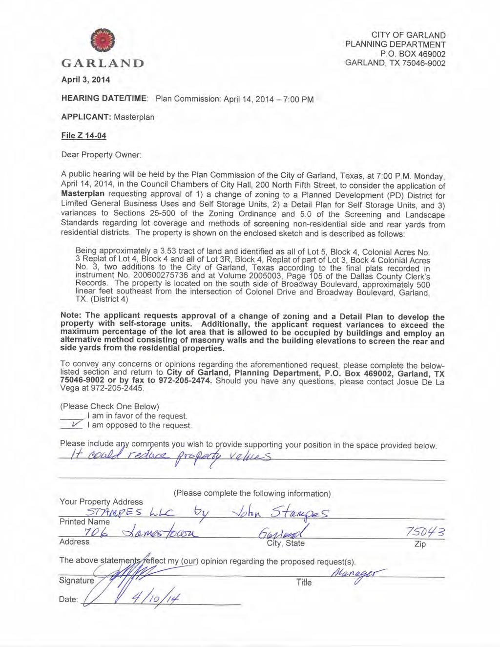
Jaime Pineda. 200 Rayburn Street
|
|
|
- Annabel Young
- 6 years ago
- Views:
Transcription

 to zero (0), recommended approval of a Specific Use Permit for Contractor Equipment")
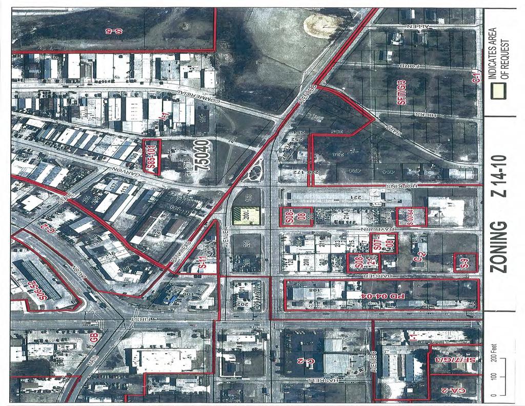
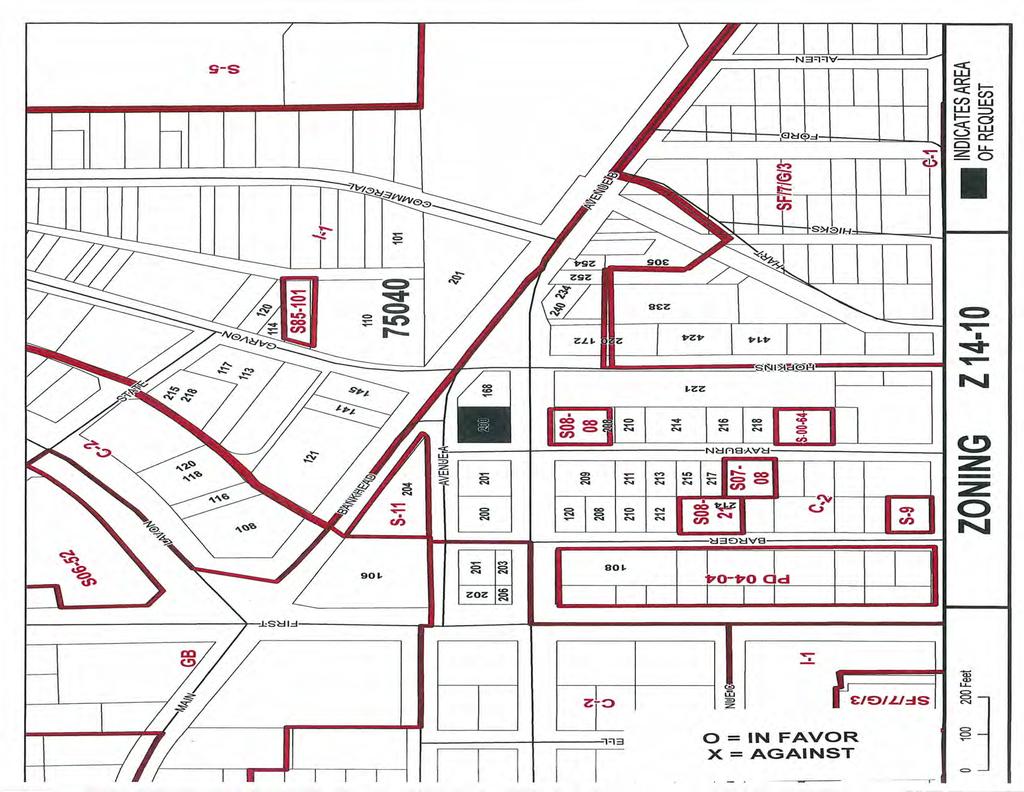
1 Planning Report File No /District 2 Meeting: City Council Date: May 6, 2014 Jaime Pineda 200 Rayburn Street REQUEST Approval of a Specific Use Permit for Contractor Equipment and Storage on a property zoned Commercial 2 (C-2) District. This request was postponed by City Council on April 15, OWNER Regions Electric PLAN COMMISSION RECOMMENDATION On March 24, 2014 the Plan Commission, by a vote of nine (9) to zero (0), recommended approval of a Specific Use Permit for Contractor Equipment and Storage for a period of five years on property zoned Commercial 2 (C-2) District. STAFF RECOMMENDATION Approval of a Specific Use Permit for Contractor Equipment and Storage for a period of 5 years and tied to Jaime Pineda provided all storage is limited to indoor storage. The proposed Contractor Equipment and Storage operation will not represent a nuisance to the adjacent properties given that all storage will be indoors and the commercial activity in the surrounding area is comparable with the proposed operation. The utilization of the subject property for the storage of contractor equipment and vehicles is appropriate and consistent with the surrounding land use pattern. BACKGROUND The subject property was developed in 1985 with a metal building that was previously occupied by an auto repair shop and retail sales/personal service. The applicant is seeking a Specific Use Permit to utilize the building as Contractor Equipment and Storage. SITE DATA The subject property contains approximately 0.2 acres and has frontage of approximately 85 linear feet along Rayburn Street, 100 linear feet along Avenue
2 Planning Report File No Page 2 A and Avenue B. The property can be accessed from Rayburn Street and Avenue B. USE OF PROPERTY UNDER CURRENT ZONING The subject property is zoned Commercial 2 (C-2) District which allows a broad range of commercial sales, service and repair activities, many of which are not appropriate in a retail or office environment. Contractor Equipment and Storage is only allowed with the approval of a Specific Use Permit. CONSIDERATIONS 1. The applicant is requesting a Specific Use Permit to utilize the building for office and indoor storage of contractor equipment and vehicles associated with an electrician business. The applicant has indicated that no outside storage will take place at this location. The site consists of a 2,990 square foot metal building with 2 overhead doors facing Rayburn Street, parking area and a yard adjacent to Avenue A that is enclosed by a chain link fence. 2. The applicant is not proposing any improvements on the subject property and existing signage will remain as is. 3. Section of the Comprehensive Zoning Ordinance stipulates a minimum parking ratio of 1 parking space for every 500 square feet of gross floor area. The minimum parking requirement for a 2,990 square foot building is 6 parking spaces; the site has 11 parking spaces. 4. The applicant is requesting a Specific Use Permit for a period of 5 years and tied to Jaime Pineda. COMPREHENSIVE PLAN The Future Land Use Map of the Envision Garland Plan recommends Business Centers for the subject property. Business Centers represent clusters of business offices and/or clean industry whose development and operations result in minimal negative effects to adjacent development types. The proposed contractor equipment and storage is congruent with the above recommendation in that it will have a minimal negative visual impact on the surrounding properties and thoroughfares given that all storage will be indoors. COMPATIBILITY OF REQUEST WITH SURROUNDING ZONING AND LAND USES The properties to the north and northeast are zoned Industrial 1 (I-1) District while the properties to the south and west are zoned Commercial 2 (C-2) District with a Specific Use Permit for Contractor Equipment and Storage. The surrounding properties are developed with buildings that are similar in character
3 Planning Report File No Page 3 as the building on the subject property and used for auto sales, auto repair, warehousing and other heavy commercial operations. Given the heavy commercial character of the surrounding area, the subject property is a suitable location for the proposed contractor equipment and storage. Prepared By: Josue De La Vega Development Planner Reviewed By: Anita Russelmann Director of Planning Date: April 25, 2014, 2014 Date: April 25, 2014 Reviewed By: William E. Dollar City Manager Date: April 28, 2014
4
5
6
7
8
9
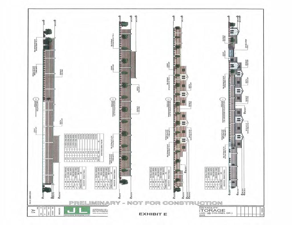
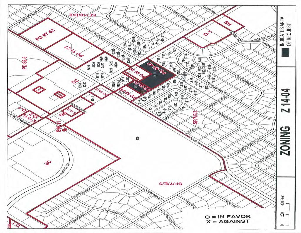
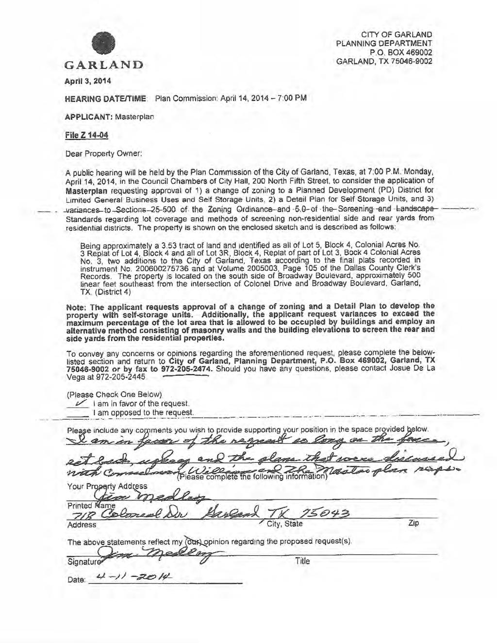
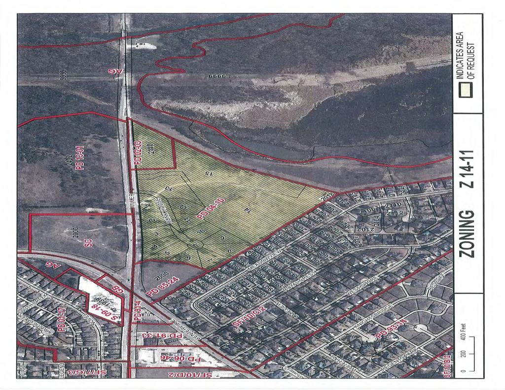
10 Planning Report File No /District 4 Meeting: City Council Date: May 6, 2014 Masterplan On the south side of Broadway Boulevard, approximately 500 linear feet southeast from the intersection of Colonel Drive and Broadway Boulevard REQUEST Approval of 1) a change of zoning from Planned Development (PD) District and Planned Development (PD) District 06-38, both for General Business Uses, to a Planned Development (PD) District for Limited General Business Uses and Self-Storage Units, 2) a Detail Plan for Self-Storage Units, and 3) a variance to Section of the Zoning Ordinance regarding lot coverage. OWNER Fino Sameer PLAN COMMISSION RECOMMENDATION On April 14, 2014 the Plan Commission, by a vote of six (6) to zero (0), recommended approval of 1) a change of zoning from Planned Development (PD) District and Planned Development (PD) District 06-38, both for General Business Uses, to a Planned Development (PD) District for Limited General Business Uses and Self-Storage Units per Staff recommendation, 2) a Detail Plan for Self-Storage Units, and 3) a variance to Section of the Zoning Ordinance to allow a maximum lot coverage of 55 percent. Additionally, the Plan Commission approved a variance to Section 5.0 of the Screening and Landscape Standards to allow an alternative screening method from the adjacent residential properties consisting of the exterior elevations of the buildings, masonry walls and 1 large tree every 30 linear feet plus shrubs planted along the exterior of the screen. STAFF RECOMMENDATION Approval of a change of zoning to a Planned Development (PD) District for Limited General Business Uses and Self-Storage Units. The introduction of selfstorage units along this sector of the Broadway Boulevard corridor will not negatively alter the character of the surrounding area since the commercial
11 Planning Report File No Page 2 intensity is similar or less than the commercial activity generated by the established retail/personal service land uses. Approval of a Detail Plan for Self-Storage Units. The various components, such as site layout, scale, façade materials, and building design being employed will make the proposed self-storage unit complex suitable for a site that is adjacent to residential properties while providing an adequate buffer between the commercial activity along Broadway Boulevard and these residential properties. Approval of a variance to Section of the Zoning Ordinance to allow a maximum lot coverage of 55 percent. The proposed lot coverage does not have a negative impact on the site layout and all required setbacks and clearances are met. BACKGROUND The subject property is presently undeveloped and consists of 2 platted lots that are zoned Planned Development (PD) District with a Detail Plan for a Restaurant with Drive-Through and Planned Development (PD) District 06-38, both Planned Development (PD) Districts for General Business Uses. The applicant seeks approval of a change of zoning to a Planned Development (PD) District and a Detail Plan to develop the subject property with self-storage units. Additionally, the applicant is requesting approval of a variance to exceed the maximum allowable lot coverage. SITE DATA The proposed self-storage units will be constructed on a 3.53-acre site that has approximately 180 linear feet of frontage along Broadway Boulevard. The site is accessed from Broadway via a common access drive that is shared with the bank site located immediately to the north. Access to the buildings housing the self-storage units will be gained through a gated vehicle entrance. USE OF PROPERTY UNDER CURRENT ZONING Planned Development (PD) District and Planned Development (PD) District limit the permitted uses on the subject property to those listed under General Business (GB) District, which excludes Self-Storage Units. The applicant proposes a change of zoning to a Planned Development (PD) District that allows limited General Business Uses and Self-Storage Units (see PD Condition (V)(A) for permitted and excluded uses).
12 Planning Report File No Page 3 CONSIDERATIONS 1. Zoning Change: The applicant is proposing to develop self-storage units on a tract of land consisting of two lots that are zoned Planned Development (PD) District and Planned Development (PD) District 06-38, both for General Business Uses. A Detail Plan was approved with Planned Development (PD) District to develop one of the lots with a 5,725 square foot restaurant with a drive-through; however, the site was not developed. Planned Development (PD) District was created to eliminate a Detail Plan previously approved on the second lot. The applicant is proposing a Planned Development (PD) District for Limited General Business Uses that includes Self Storage Units. Self-Storage Units are only allowed in the Commercial 1 (C-1), Commercial 2 (C-2) and Industrial 1 (I-1) which are more commercial intensive in character than General Business (GB) District. 2. Detail Plan: The applicant proposes a Detail Plan to develop the site with 85,300 square feet of self-storage units and 2,200 square feet of office/custodial quarters. The self-storage units will be distributed among 8 buildings that range in size from 2,800 square feet to 16,925 square feet (minus office/custodial quarters). Six of the buildings are 1-story and two buildings are 2-stories. The two 2-story buildings are setback approximately 90 feet from the residential properties to the southwest, 145 feet from the residential properties to the southeast and 270 feet from Broadway Boulevard. The parking ratio for a Self- Storage Units is 4 per complex. The Detail Plan provides 6 parking spaces. 3. Variance to lot coverage: Section of the Comprehensive Zoning Ordinance estates that buildings or structures cannot be erected, altered, or placed so as to cover more than 40 percent of the lot area. The applicant requests approval of a variance to allow the buildings to cover up to 54 percent of the subject property. 4. Screening and Landscape: All applicable screening and landscape standards are met with the exception of the prescribed methods of screening non-residential side and rear yards from residential districts. The Plan Commission approved a variance to allow an alternative side yard and rear yard screening method consisting of the exterior elevations of the buildings, masonry walls and 1 large tree every 30 linear feet plus shrubs planted along the exterior of the screen. This alternative screening method results in a superior and more secure screen than some of the prescribed screening methods that consist of vegetation and an open fence. 5. Elevations: The proposed building elevations consist of brick and stone with EIFS bands and molding. 6. Signage: The only signage being proposed is one monument sign that is in full compliance with the Sign Ordinance.
13 Planning Report File No Page 4 COMPREHENSIVE PLAN The Envision Garland Plan designates the subject property as Neighborhood Center. Neighborhood Centers provide a mix of retail, services and community gathering places. These areas should be appropriately scaled to adjacent residential areas. The proposed self-storage units are consistent with the recommendation of the Envision Garland Plan in that the scale and architectural style of the overall complex is suitable with the surrounding residential developments. COMPATIBILITY OF REQUEST WITH SURROUNDING ZONING AND LAND USES Most of the surrounding properties are zoned Single Family (SF) District and are developed with single family homes and South Garland High School, with the exception of the properties near the intersection of Colonel Drive and Broadway Boulevard. These properties are zoned Shopping Center (SC) District and with a range of Planned Development (PD) Development Districts for Shopping Center Uses and General Business Uses and developed with a number of retail and personal service uses - Although self-storage units are only allowed in more commercially intensive districts such as Commercial 1 (C-1) and Commercial 2 (C-2) District, their commercial intensity is comparable with the retail and personal service uses present in the surrounding. Furthermore, the proposed self-storage units have an enhanced architectural design that makes them a suitable development for a site that is adjacent to residential properties. Prepared By: Josue De La Vega Development Planner Reviewed By: Anita Russelmann Director of Planning Date: April 25, 2014 Date: April 28, 2014 Reviewed By: William E. Dollar City Manager Date: April 29, 2014
14
15
16
17
18
19
20
21
22
23
24
25
26
27
28
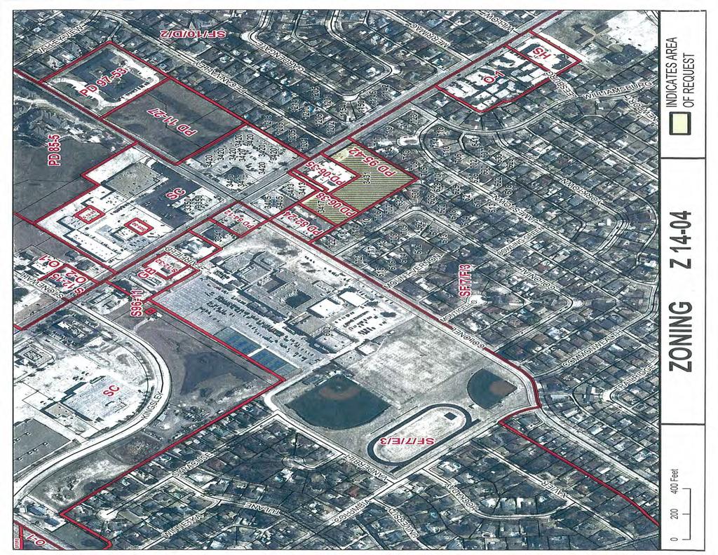
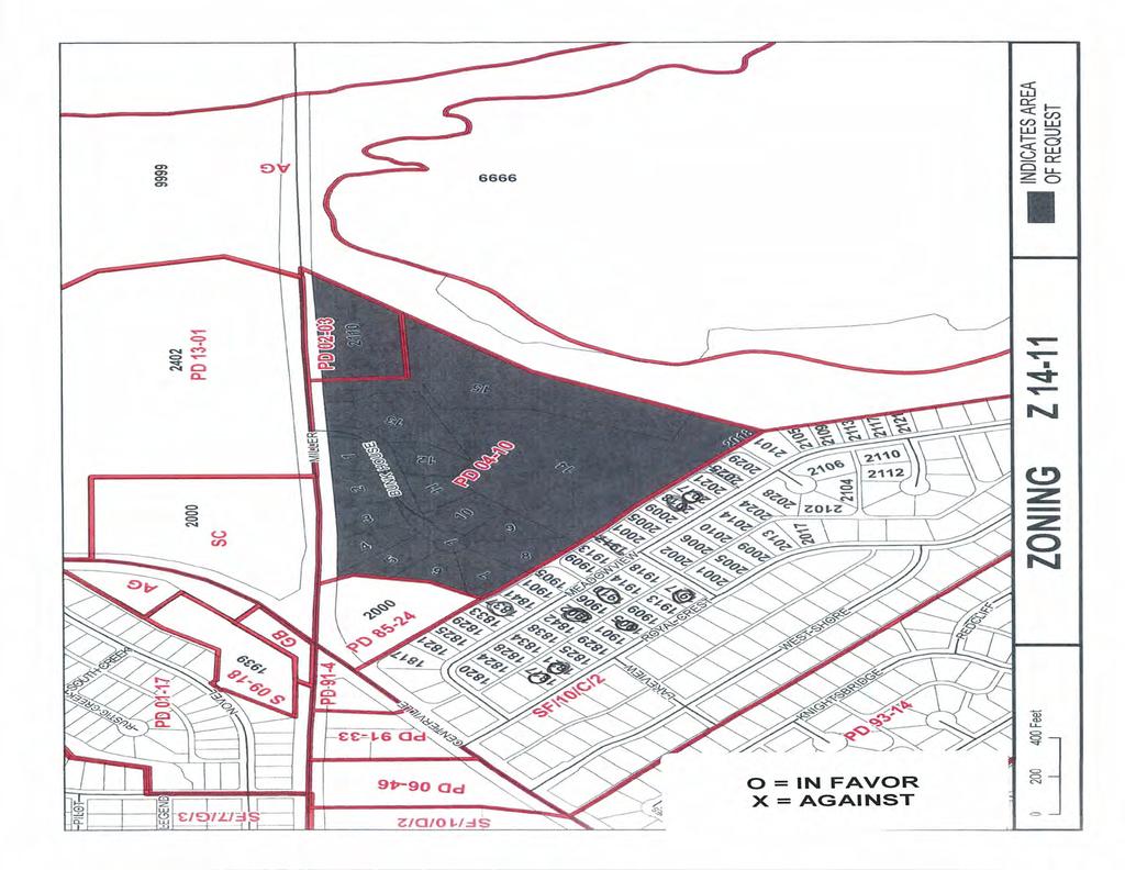
29 Planning Report File No /District 3 Meeting: City Council Date: May 6, 2014 Merriwood Ranch Southeast of the intersection of East Miller Road and East Centerville Road REQUEST Approval of 1) an amendment to Planned Development Districts (04-10 and 02-03) for Single Family Uses, Design Center, Stables and Barns, and 2) a Detail Plan for a Riding Academy/Stables and Day Camp. OWNER Sooner Ranch Properties PLAN COMMISSION RECOMMENDATION On April 14, 2014 the Plan Commission, by a vote of five (5) to zero (0), recommended approval of 1) an amendment to Planned Development Districts (04-10 and 02-03) for Single Family Uses, Design Center, Stables and Barns, and 2) a Detail Plan for a Riding Academy/Stables and Day Camp. STAFF RECOMMENDATION Approval of 1) an amendment to Planned Development Districts (04-10 and 02-03) for Single Family Uses, Design Center, Stables and Barns, and 2) a Detail Plan for a Riding Academy/Stables and Day Camp. The proposed request is consistent with the recommendation of Envision Garland in that a portion of the property will be developed with single family homes. The nature of the riding academy and day camp is such that the uses are compatible within a ranch style single family residential area desired to be within an agricultural setting. BACKGROUND The subject property is currently zoned Planned Development (PD) Districts and for Single Family, Stables, Office and Accessory Uses and has never developed. The entire property was originally incorporated into PD with a detail plan that reflected eight single family lots on the original Tract 1, a design center, stables and barns on Tract 3, and future office on Tract 2. In 2004, a revised detail plan was approved under PD which included a Detail Plan for twelve single family lots on Tract 1, and a design center, stables, barns and 2 residences on Tract 3. Tract 2 was not included in the PD The applicant requests amendments to the existing Planned Developments to add riding academy and day camp uses and amend the Detail Plan to reflect the new building locations for a clubhouse, barns and shade structures to be used in
30 Planning Report File No Page 2 association with the proposed uses. The 7.39-acre portion originally identified as twelve single family lots will be subject to future Detail Plan approval. SITE DATA The subject property contains acres with approximately 1,644 feet of frontage along East Miller Road. USE OF PROPERTY UNDER CURRENT ZONING The subject property is currently zoned Planned Development (PD) Districts and for Single Family, Stables, Office and Accessory Uses (Design Center, Barns). The intent of the original PD was to create a single family subdivision with horse stables and barns to create a ranch style development. The subsequent PD further refined that vision by putting into place conditions related to the development of single family homes on a portion of the property and still allow for stables, barns and the relocation of the existing homes on the property at the time. While the current Planned Development Districts allow for stables, the request to amend the uses to allow riding academy and day camp solidifies the proposed use as more commercial in nature than the originally intended private stable/ranch style development. CONSIDERATIONS 1. Merriwood Ranch, formerly located in north Garland, is a riding academy that offers riding lessons and summer camps for children ages 7 to 14 years old. The applicant intends to continue this operation on the subject property with approval of the request. Riding lessons are offered Tuesday through Saturday, during the school year, in the morning and afternoon. The summer camp is typically held during June and July, Monday through Friday from 9:00am to 4:00pm. 2. The proposed 1,950 square foot clubhouse/office reflected on the Detail Plan will be utilized for restroom facilities, changing rooms, and a common area for games and other activities. The proposed 1,600 square foot barn will house the equipment necessary for the proposed use (saddles, bridles, reins, tractor, and mower) and include a small office of administrative tasks. Due to the use of the property as a summer camp and nature of outdoor activities, the applicant proposes to construct approximately 4 shade structures. There will also be some accessory structures constructed for operation with the horses (loafing sheds). There is a single family home, currently permitted, that will be constructed at the southern end of the property that will be occupied as a caretaker s quarters. 3. The current Planned Development conditions added provisions for building materials of the clubhouse, barns and single family homes. The applicant is proposing to maintain those conditions which allow for the clubhouse to be constructed of wood siding and the barn to be constructed of architecturally designed metal.
31 Planning Report File No Page 3 4. Single Family Development: As previously stated, the approximately acre portion of the property that currently allows for single family residences is still proposed for that use. However, a new Detail Plan shall be approved to reflect a revised lot configuration given the changes created with the proposed riding academy/day camp. The applicable conditions that were approved under PD have been retained to ensure the original nature of the single family portion of the development is maintained. 5. Access: Access to the site will be from East Miller Road. There is an existing access easement that extends from the alley to the south which can be used to access the single family home at the southern end of the property (caretaker s quarters). 6. Screening/Landscaping: There were specific conditions approved within PD and regarding fencing and screening features on the site. Those provisions have been maintained and slightly modified to reflect a change from wood fence to wrought iron fence for the portion of fence along the west property line. Details of the screening wall, landscaping, and entry features of the future single family development will be provided at the time of Detail Plan approval. The portion of the property that will be developed with the clubhouse, barn, shade structures and parking area will meet the requirements of the Screening and Landscape Ordinance including landscape buffer and required trees, parking lot landscaping and screening. 7. The site is a known former landfill and an environmental report has been completed on the portion of the property to be developed with the riding academy and day camp. Based on those findings, the applicant shall be required to satisfy the City of Garland Health Department and TCEQ requirements prior to disturbing the landfill area or issuance of a site and/or building permit as a condition of the Planned Development. COMPREHENSIVE PLAN The Future Land Use Map of the Envision Garland Plan recommends Traditional Neighborhoods for the subject property. Traditional neighborhoods provide areas for low to moderate density single-family detached residential housing. Traditional neighborhoods also accommodate convenience retail (goods and services), office space, and public services. The Traditional Neighborhood development type is primarily characterized as low density, single-family detached (between one and six dwelling units per acre). The proposed request is consistent with the recommendation of Envision Garland in that a portion of the property will be developed with single family homes. The nature of the riding academy and day camp is such that the uses are compatible within a ranch style single family residential area desired to be within an agricultural setting. COMPATIBILITY OF REQUEST WITH SURROUNDING ZONING AND LAND USES The surrounding area is primarily zoned for and developed with single family residences. The property to the north, across East Miller Road, is zoned Planned Development (PD) for Single Family uses. Properties to the east and northeast across East Miller Road are zoned Agriculture (AG) District and are
32 Planning Report File No Page 4 undeveloped. Properties at the intersection of Miller and Centerville Roads are zoned Shopping Center District and Planned Development for Shopping Center Uses and are undeveloped. The use of the property for low to medium density residential is consistent with the existing development pattern in the surrounding area. In addition, the conditions proposed will encourage future development of the single family development to be designed in a manner compatible with the proposed equestrian use on the remaining portion of property. The riding academy and day camp, while more commercial in nature than the originally approved stables and barns, add to the original vision of the site as a more agricultural setting. Prepared By: Chasidy Allen, AICP Principal Planner Reviewed By: Anita Russelmann Director of Planning Date: April 24, 2014 Date: April 25, 2014 Reviewed By: William E. Dollar City Manager Date: April 28, 2014
33
34

35
36
37
38
39
40
41
42
43
44
45
46
47
48
49
50
51
52
53
54
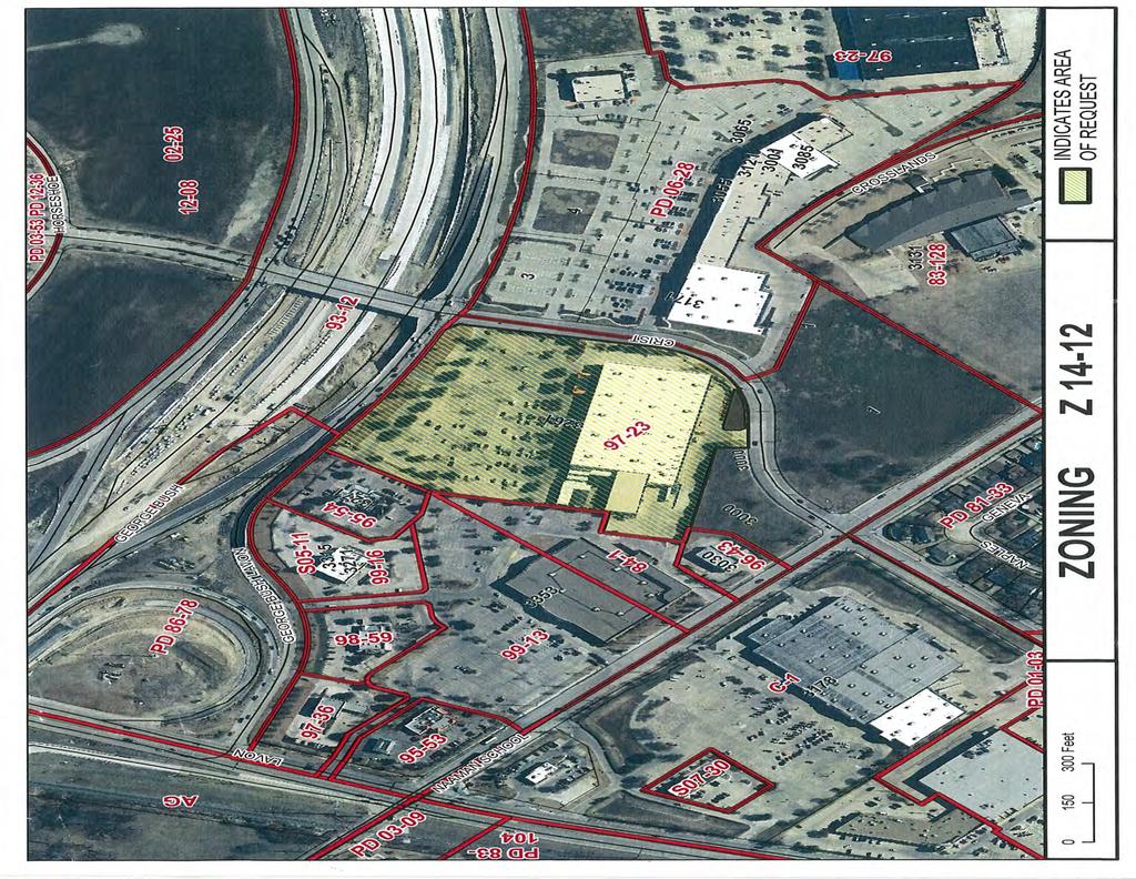
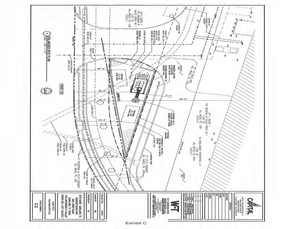
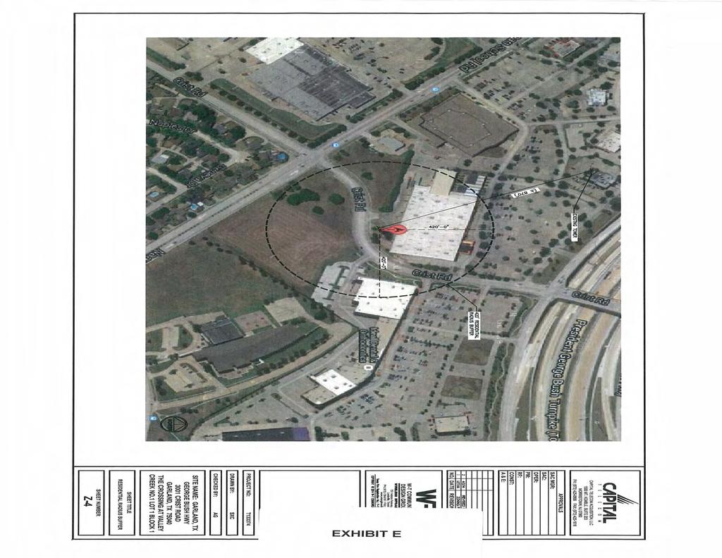
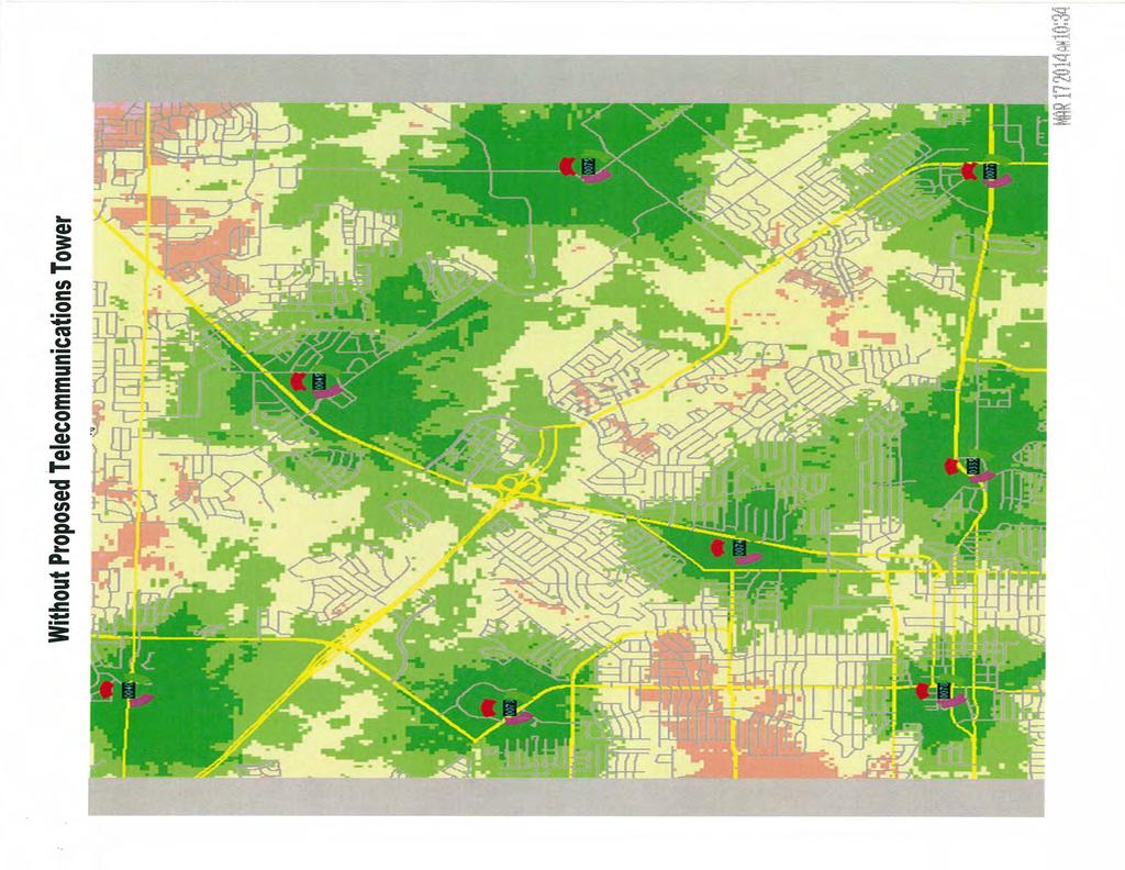
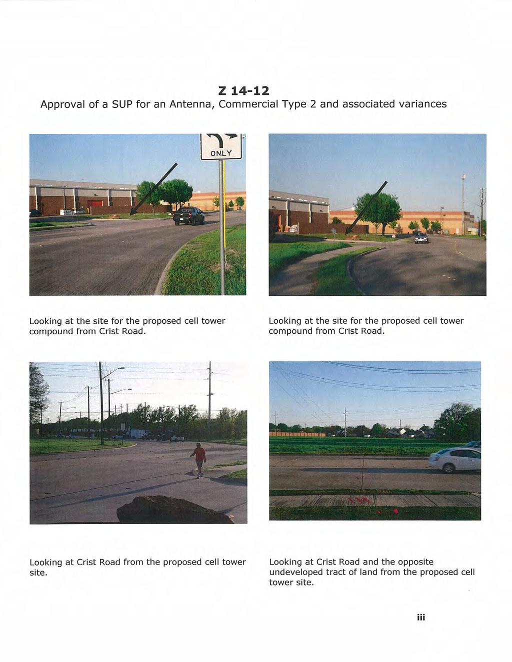
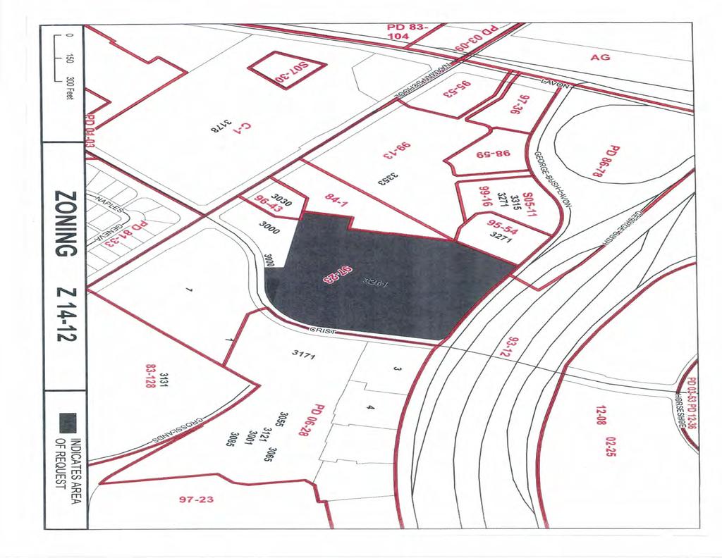
55 Planning Report File No /District 1 Meeting: City Council Date: May 6, 2014 Capital Telecom Approximately 450 feet northeast of the intersection of Crist Road and Naaman School Road, behind the Home Depot located at 3261 North President George Bush Highway. REQUEST Approval of 1) a Specific Use Permit for an Antenna, Commercial Type 2 on property zoned Planned Development (PD) District for Shopping Center Uses and in the SH 190 Overlay and 2) variances to Sections (C) and of the Zoning Ordinance regarding the minimum required distance between two cell towers and the minimum required setback from the public rightof-way. OWNER HD Development Properties, LP PLAN COMMISSION RECOMMENDATION On April 14, 2014 the Plan Commission, by a vote of six (6) to zero (0), recommended approval of 1) a Specific Use Permit for an Antenna, Commercial Type 2 on property zoned Planned Development (PD) District for Shopping Center Uses and in the SH 190 Overlay and 2) variances to Sections (C) and of the Zoning Ordinance to allow the proposed cell tower to be located less than 3,000 feet from the nearest existing cell tower and to reduce the setback to the right-of-way of Crist Road to 25 feet. STAFF RECOMMENDATION Denial of 1) a Specific Use Permit for an Antenna, Commercial Type 2 and 2) variances to Sections (C) and of the Zoning Ordinance. With a height of 140 feet and located just 25 feet from the right-of-way of Crist Road, the proposed cell tower will have a negative visual impact on the public thoroughfare and any future development that will have frontage along Crist Road, making this site less than a suitable location for a cell tower.
56 Planning Report File No Page 2 BACKGROUND The subject property was developed in 1995 with a Home Depot. The applicant is proposing to lease a portion of the subject property to construct a cell tower, associated equipment and enclosure. The applicant proposes to place the cell tower at a distance less than the minimum required between two cell tower sites and to have a reduced setback from the proposed cell tower improvements and the public right-of-way along Crist Road. SITE DATA The proposed lease area is acres and has a frontage along Crist Road of approximately 130 feet. The site can be accessed from Crist Road through an existing paved access easement. USE OF PROPERTY UNDER CURRENT ZONING The intent of Planned Development (PD) District 97-23, which originally encompassed the subject property and the surrounding commercial sites, was to permit the development of a variety of retail, restaurant and commercial services while ensuring compatibility with the proposed surrounding land uses. Allowable uses are those listed in the Shopping Center District in the SH 190 Overlay; however, Antenna, Commercial Type 2 is only allowed with an approved Specific Use Permit. CONSIDERATIONS 1. The applicant proposes to lease acres from the acre Home Depot site and develop a cell tower compound that will consist of a 140-foot tall stealth flagless flag pole cell tower, associated ground equipment and a 6-foot high split face CMU wall enclosure. The site of the proposed cell tower compound is currently a grassy area located behind the existing Home Deport building, between the rear driveway and the public right-of-way of Crist Road. Cell towers are classified as Antenna, Commercial Type 2 and they should only be allowed at locations where they will not dominate the view from the public right-of-way or adjacent residential properties. 2. The applicant requests a variance to Section (C) of the Comprehensive Zoning Ordinance which requires all cell towers designed and built to be capable of use by two or more wireless communications providers to be separated from another cell tower by a minimum distance of 3,000 linear feet. The proposed cell tower will be approximately 870 linear feet from the nearest existing cell tower which is located at 3271 North President George Bush Highway, on the same site as the Chili s Restaurant. The applicant contends
57 Planning Report File No Page 3 that co-location of their antennas on the nearest existing cell tower is not an option since the 70-foot height of the existing cell tower is not adequate to provide the desired coverage which can be provided with a 140-foot tall cell tower constructed on the subject site. 3. The applicant seeks a variance to Section of the Comprehensive Zoning Ordinance which stipulates a minimum setback of 60 feet from the public right-of-way to any structure. The proposed cell tower compound will be located 25 feet from the public right-of-way of Crist Road. 4. The applicant requests approval of a Specific Use Permit for 30 years. COMPREHENSIVE PLAN The Future Land Use Map of the Envision Garland Plan recommends Community Centers for the subject site. Community centers are areas with compact development, primarily non-residential, serving a collection of neighborhoods. This type of development consists of a mix of uses, including retail, services, office use, multi-family residential, and entertainment. Community centers may be developed at the intersections of major arterial streets and along major arterials, highways, and turnpike corridors. This type of area is served by numerous roads and transit routes, providing a variety of connections between neighborhoods and Community Centers for pedestrians, bicycles, motorized vehicles, and transit. The development standards employed to create Community Centers should enhance gateways and corridors as well as to provide attractive, modern developments that create desirable destinations within the city. The proposed cell tower site is not consistent with the recommendation of the Future Land Use Map in that its proximity to the public right-of-way and size will negatively impact the streetscape of Crist Road, a highly trafficked thoroughfare leading from the nearby residential developments to the President George Bush Turnpike and Firewheel Town Center. COMPATIBILITY OF REQUEST WITH SURROUNDING ZONING AND LAND USES The surrounding properties are zoned with a variety of Planned Development (PD) Districts and developed with a cluster of retail, personal service, restaurant and office uses that front on President George Bush Turnpike, Naaman School Road, Crist Road, Firewheel Parkway, and Lavon Drive. The properties further south, across Naaman School Road and Mars Drive, are zoned with various Planned Development (PD) Districts and developed with single family residences.
58 Planning Report File No Page 4 Cell towers provide a valuable communication service to nearby commercial and residential developments. However, if placed on the proposed site, the cell tower will be highly conspicuous from the public right-of-way and will have a negative visual impact on any future development on the vacant tract of land across Crist Road whose frontage will most likely be oriented towards the cell tower site. A less visible site from which the same level of coverage can be provided would make a more adequate location for a cell tower. Prepared By: Josue De La Vega Development Planner Reviewed By: Anita Russelmann Director of Planning Date: April 25, 2014 Date: April 28, 2014 Reviewed By: William E. Dollar City Manager Date: April 29, 2014
59
60
61
62
63
64
65
66
67
68

69
DEVELOPMENT DEPARTMENT STAFF REPORT DRESDEN HEIGHTS PHASE II DCI
 DEVELOPMENT DEPARTMENT Meeting Date: January 10, 2019 Item #: PZ2019-393 Project Name: Applicant and Owner: Proposed Development: Requests: STAFF REPORT DRESDEN HEIGHTS PHASE II DCI Dresden Heights Phase
City of Colleyville City Council Agenda Briefing
 City of Colleyville City Council Agenda Briefing City Hall 100 Main Street Colleyville, Texas 76034 www.colleyville.com Agenda Number 5a Agenda Date 01/06/2015 Number Ordinance O-14-1942 Type Ordinance
THE CITY OF RAYMORE, MISSOURI Single-Family Residential Zoning Districts
 THE CITY OF RAYMORE, MISSOURI Single-Family Residential Zoning Districts REGULATIONS COMMON TO ALL DISTRICTS: Uses permitted in each district include detached single-family dwellings, manufactured homes
Development Plan DP13-3 (Arlington Lofts) Planning and Zoning Meeting Date: Document Being Considered: Ordinance
 Planning and Zoning Meeting Date: Document Being Considered: Ordinance") Staff Report Development Plan DP13-3 (Arlington Lofts) Planning and Zoning Meeting Date: 6-19-13 Document Being Considered: Ordinance RECOMMENDATION Following the public hearing, consider Development Plan
Staff Report Development Plan DP13-3 (Arlington Lofts) Planning and Zoning Meeting Date: 6-19-13 Document Being Considered: Ordinance RECOMMENDATION Following the public hearing, consider Development Plan
ARTICLE C. ZONING TEXT, DISTRICT CLASSIFICATIONS AND BOUNDARIES
 ARTICLE C. ZONING TEXT, DISTRICT CLASSIFICATIONS AND BOUNDARIES Sec. 10-2054. ZONING TEXT, DISTRICT CLASSIFICATIONS AND BOUNDARIES. In order to regulate the location of structures, the height and bulk
PLANNING RATIONALE 680 BRONSON AVENUE OTTAWA, ONTARIO PROPOSED ZONING BY-LAW AMENDMENT
 PLANNING RATIONALE 680 BRONSON AVENUE OTTAWA, ONTARIO PROPOSED ZONING BY-LAW AMENDMENT FRANK PARAVAN APRIL 2014 Planning Rationale Introduction FOTENN Consultants Inc. has been engaged by Frank and Michael
Proposed Overland Park Kansas Ordinance RE-1 Residential Estates Community
 18.171 RE-1 Residential Estate Community 18.171.010 Statement of intent. The zoning of property as RE-1, (Residential Estates Community, 1 dwelling unit per Gross acre density), is intended to provide
PD No. 15 Authorized Hearing
 PD No. 15 Authorized Hearing Community Meeting No. 2 February 19, 2019 6:30 p.m. Hyer Elementary School Cafetorium 8385 Durham St Andrew Ruegg Senior Planner PD No. 15 Authorized Hearing On September 7,
RE: 6. GILL/GREEN COMPREHENSIVE PLAN AMENDMENT, REZONING AND PRELIMINARY PLAT
 commission memo DATE: Thursday - August 9, 2018 TO: Marion Planning & Zoning Commission FROM: David N. Hockett, AICP Principal Planner RE: 6. GILL/GREEN COMPREHENSIVE PLAN AMENDMENT, REZONING AND PRELIMINARY
DEVELOPMENT DEPARTMENT STAFF REPORT THE PARK AT 5 TH
 DEVELOPMENT DEPARTMENT STAFF REPORT ARB Meeting Date: July 3, 2018 Item #: _PZ2018-293_ THE PARK AT 5 TH Request: Site Address: Project Name: Parcel Number: Applicant: Proposed Development: Current Zoning:
PD No. 15 Authorized Hearing Steering Committee Meeting #11
 PD No. 15 Authorized Hearing Steering Committee Meeting #11 January 7, 2019 Andrew Ruegg, Senior Planner Sustainable Development and Construction City of Dallas Staff Recommendation Steering committee
PLANNING ANALYSIS ZONING CASE 18-TOD-Z-026 NAK S CROSSING PUD AMENDMENT. GC-3-A (General Commercial) GC-3-A (General Commercial)
 GC-3-A (General Commercial)") PLANNING ANALYSIS ZONING CASE 18-TOD-Z-026 NAK S CROSSING PUD AMENDMENT GENERAL INFORMATION Applicant/Owner: Current Zoning: Bruce Nakfoor PUD/TOD (Planned Unit Development/Transit Oriented Development
PLANNING ANALYSIS ZONING CASE 18-TOD-Z-026 NAK S CROSSING PUD AMENDMENT GENERAL INFORMATION Applicant/Owner: Current Zoning: Bruce Nakfoor PUD/TOD (Planned Unit Development/Transit Oriented Development
ARTICLE 5.0 SCHEDULE OF REGULATIONS
 ARTICLE 5.0 SCHEDULE OF REGULATIONS Section 5.101 Table of Dimensional Standards by District. Dimensional Standards AG AG with sewer Districts Rural Residential Business Other SF SF with sewer R-1 R-1
Town of Windham Land Use Ordinance Sec. 400 Zoning Districts SECTION 400 ZONING DISTRICTS
 Town of Windham Land Use Ordinance Sec. 400 Zoning Districts Sections SECTION 400 ZONING DISTRICTS SECTION 400 ZONING DISTRICTS 4-1 401 Districts Enumerated 4-2 402 Location of districts; Zoning Map 4-2
RESIDENTIAL DISTRICTS
 RESIDENTIAL DISTRICTS RESIDENTIAL DISTRICTS The residential district standards have been revised to reflect on-the-ground development conditions, while continuing to respect the use patterns established
Cover Letter with Narrative Statement
 Cover Letter with Narrative Statement March 31, 2017 rev July 27, 2017 RE: Rushton Pointe Residential Planned Unit Development Application for Public Hearing for RPUD Rezone PL2015 000 0306 Mr. Eric Johnson,
525 Yacht Club Road Oak Point, Texas p f
 ZONING VCM Prestonwood Polo Development, Ltd has re-zoned the 97.08 acre Prestonwood Polo Club property into 22 exclusive home sites overlooking lush 3 green polo fields. Careful attention has been paid
Regular Meeting and Public Hearing of the Zoning Subcommittee
 Regular Meeting and Public Hearing of the Zoning Subcommittee Tuesday, September 05, 2017 7:00 PM Council Chambers, City Hall, 2nd Floor, 27 West Main Street, New Britain, Connecticut NOTICE - The Common
COMMERCIAL/INDUSTRIAL DEVELOPMENT GUIDELINES
 COMMERCIAL/INDUSTRIAL DEVELOPMENT GUIDELINES Planning Division Sections Chapter 17.16 Commercial, Industrial Development Standards 17.16.010 Lot Size 17.16.020 Setbacks 17.16.030 Fences, Hedges and Walls
9. REZONING NO Vicinity of the northwest corner of 143 rd Street and Metcalf Avenue
 9. REZONING NO. 2002-15 Vicinity of the northwest corner of 143 rd Street and Metcalf Avenue 1. APPLICANT: Andrew Schlagel is the applicant for this request. 2. REQUESTED ACTION: The applicant is requesting
4.2 RESIDENTIAL ZONING DISTRICTS
 4.2 RESIDENTIAL ZONING DISTRICTS A. Purpose: To define regulations and standards for each residential zoning district in the City. The following sections identify uses, regulations, and performance standards
ARTICLE 3: Zone Districts
 ARTICLE 3: Zone Districts... 3-1 17.3.1: General...3-1 17.3.1.1: Purpose and Intent... 3-1 17.3.2: Districts and Maps...3-1 17.3.2.1: Applicability... 3-1 17.3.2.2: Creation of Districts... 3-1 17.3.2.3:
Part 4, C-D Conservation District
 The Township is divided into the districts set forth by this chapter and as shown by the district boundaries on the Official Zoning District Map. The zoning districts are: C-D Conservation District A-1
Planning Justification Report
 Planning Justification Report Kellogg s Lands City of London E&E McLaughlin Ltd. June 14, 2017 Zelinka Priamo Ltd. Page i TABLE OF CONTENTS Page No. 1.0 2.0 2.1 2.2 3.0 4.0 5.0 5.1 5.2 5.3 5.4 5.5 5.6
Article 3. SUBURBAN (S-) NEIGHBORHOOD CONTEXT
 NEIGHBORHOOD CONTEXT") Article 3. SUBURBAN (S-) NEIGHBORHOOD CONTEXT this page left intentionally blank Contents ARTICLE 3. SUBURBAN (S-) NEIGHBORHOOD CONTEXT DIVISION 3.1 NEIGHBORHOOD CONTEXT DESCRIPTION...3.1-1 Section 3.1.1
Article 3. SUBURBAN (S-) NEIGHBORHOOD CONTEXT this page left intentionally blank Contents ARTICLE 3. SUBURBAN (S-) NEIGHBORHOOD CONTEXT DIVISION 3.1 NEIGHBORHOOD CONTEXT DESCRIPTION...3.1-1 Section 3.1.1
City of Valdosta Land Development Regulations
 Chapter 206 Section 206-1 Base Zoning Districts Standards for Uses, Structures, and Property Development (B) (C) Principal Uses and Structures. Principal uses and structures permitted in each base zoning
DOUGLAS COUNTY ZONING RESOLUTION Section 4 LRR - Large Rural Residential District 3/10/99. -Section Contents-
 SECTION 4 LRR LARGE RURAL RESIDENTIAL DISTRICT -Section Contents- 401 Intent... 4-2 402 Principal Uses... 4-2 403 Accessory Uses... 4-3 404 Uses Permitted by Special Review... 4-4 405 Land Dedication...
DEVELOPMENT DEPARTMENT STAFF REPORT STAFF REPORT EASTSIDE CHAMBLEE LINK DCI
 DEVELOPMENT DEPARTMENT STAFF REPORT Public Hearing Date: April 12, 2018 Item #: PZ-2018-248 STAFF REPORT EASTSIDE CHAMBLEE LINK DCI Request: Development of Community Compact (DCI), ten concurrent variances,
CHARLOTTE CODE. PART 1: PURPOSE AND PART 2: MIXED USE DISTRICTS (MX-1, MX-2, and MX-3) CHAPTER 11:
 CHAPTER 11:") PART 1: PURPOSE AND PART 2: MIXED USE DISTRICTS (MX-1, MX-2, and MX-3) Section 11.101. Purpose. CHAPTER 11: CONDITIONAL ZONING DISTRICTS PART 1: PURPOSE The Conditional Zoning Districts allow for the establishment
PART 1: PURPOSE AND PART 2: MIXED USE DISTRICTS (MX-1, MX-2, and MX-3) Section 11.101. Purpose. CHAPTER 11: CONDITIONAL ZONING DISTRICTS PART 1: PURPOSE The Conditional Zoning Districts allow for the establishment
Midwest City, Oklahoma Zoning Ordinance
 2010 Midwest City, Oklahoma Zoning Ordinance 9/2/2010 Table of Contents Section 1. General Provisions... 5 1.1. Citation... 5 1.2. Authority... 5 1.3. Purpose... 5 1.4. Nature and Application... 5 1.5.
CHAPTER 6 RESIDENTIAL DISTRICTS LOW DENSITY RESIDENTIAL DISTRICT (R-1)
") TYPE OF DISTRICT: TRADITIONAL CHAPTER 6 RESIDENTIAL DISTRICTS LOW DENSITY RESIDENTIAL DISTRICT (R-1) ARTICLE 1: LOW DENSITY RESIDENTIAL DISTRICT (R-1) SECTION 6-1.01: PURPOSE The regulations of the R-1
TYPE OF DISTRICT: TRADITIONAL CHAPTER 6 RESIDENTIAL DISTRICTS LOW DENSITY RESIDENTIAL DISTRICT (R-1) ARTICLE 1: LOW DENSITY RESIDENTIAL DISTRICT (R-1) SECTION 6-1.01: PURPOSE The regulations of the R-1
ARTICLE III: LAND USE DISTRICTS 304 R 9 DISTRICT
 ARTICLE III: LAND USE DISTRICTS III 23 304 R 9 DISTRICT (RESIDENTIAL 9 UNITS PER ACRE) 304 1 Intent and Purpose The R 9 District is intended to implement the policies of the Comprehensive Plan for areas
Introduction. Background DEPARTMENT OF COMMUNITY DEVELOPMENT SERVICES. Planning Division. m e m o r a n d u m TO: The Urbana Zoning Board of Appeals
 DEPARTMENT OF COMMUNITY DEVELOPMENT SERVICES Planning Division m e m o r a n d u m TO: FROM: The Urbana Zoning Board of Appeals Christopher Marx, AICP, Planner I DATE: March 16, 218 SUBJECT: ZBA Case ZBA-218-C-2:
REPORT TO PLANNING & ZONING COMMISSION - CITY OF MARYLAND HEIGHTS
 APPLICATION NUMBER APPLICATION (PROJECT) NAME APPLICANT NAME PROPERTY OWNER NAME CUP16-0003 CENTRAL POWER SYSTEMS & SERVICES, INC. Central Power Systems & Services, Inc. 900 Liberty Drive, Liberty, MO
DEVELOPMENT DEPARTMENT STAFF REPORT STAFF REPORT PUD/DCI BAINBRIDGE MIXED-USE DEVELOPMENT
 DEVELOPMENT DEPARTMENT STAFF REPORT Meeting Date: October 12, 2017 Item #: _PZ-2017-170_ STAFF REPORT PUD/DCI BAINBRIDGE MIXED-USE DEVELOPMENT Request: Project Name: Planned Unit Development (PUD)/ Development
A. Land Use Relationships
 Chapter 9 Land Use Plan A. Land Use Relationships Development patterns in Colleyville have evolved from basic agricultural and residential land uses, predominate during the early stages of Colleyville
Planning Department Oconee County, Georgia STAFF REPORT
 Planning Department Oconee County, Georgia STAFF REPORT REZONE CASE #: 7332 DATE: November 28, 2017 STAFF REPORT BY: Gabriel Quintas, Planner APPLICANT NAME: Smith Planning Group PROPERTY OWNER: John Hadden
(B) On lots less than 1.5 acres, accessory buildings shall have a maximum size of 672 square feet in area.
 On lots less than 1.5 acres, accessory buildings shall have a maximum size of 672 square feet in area.") Setbacks in Commercial Districts: (1) Downtown Business District: Setbacks from State Highways 70 and 155 shall be the lesser of a minimum of 100 feet or the footprint of the present principal building
Setbacks in Commercial Districts: (1) Downtown Business District: Setbacks from State Highways 70 and 155 shall be the lesser of a minimum of 100 feet or the footprint of the present principal building
ARTICLE 143. PD 143.
 ARTICLE 143. PD 143. SEC. 51P-143.101. LEGISLATIVE HISTORY. PD 143 was established by Ordinance No. 17685, passed by the Dallas City Council on February 2, 1983. Ordinance No. 17685 amended Ordinance No.
APPENDIX D: DEFINITIONS
 D APPENDIX D: DEFINITIONS Terms used throughout the 2040 Comprehensive Plan should be interpreted using the definitions provided in this appendix. For interpretation of any term not defined, defer to the
d. DWELLING, GROUP QUARTERS (no more than sixteen [16] persons, including domestic servants and resident staff).
![d. DWELLING, GROUP QUARTERS (no more than sixteen [16] persons, including domestic servants and resident staff).](/thumbs/93/113051450.jpg "d. DWELLING, GROUP QUARTERS (no more than sixteen [16] persons, including domestic servants and resident staff).") SEC. 37-7.5. R-5 GENERAL RESIDENCE DISTRICT The R-5 General Residence District is established to provide for a range of low density residential accommodations and life styles representing a compatible
SEC. 37-7.5. R-5 GENERAL RESIDENCE DISTRICT The R-5 General Residence District is established to provide for a range of low density residential accommodations and life styles representing a compatible
AGENDA. a. Carol Crews Special Exception Hair Salon (Continued from February) b. James Barber Special Exception Horse
 b. James Barber Special Exception Horse") Baker County Land Planning Agency (LPA) Thursday, April 23, 2015 Baker County Administration Building 55 North Third Street Macclenny, FL 32063 (904) 259-3354 AGENDA 5:OO P.M. LDR Mining Workshop A. Draft
Baker County Land Planning Agency (LPA) Thursday, April 23, 2015 Baker County Administration Building 55 North Third Street Macclenny, FL 32063 (904) 259-3354 AGENDA 5:OO P.M. LDR Mining Workshop A. Draft
CHAPTER 2 GENERAL PROVISIONS
 CHAPTER 2 GENERAL PROVISIONS 200 ZONING DISTRICTS ESTABLISHED 201 SUPPLEMENTAL DISTRICTS ESTABLISHED 202 OFFICIAL ZONING MAP ESTABLISHED 203 DISTRICT BOUNDARY DESCRIPTION and INTERPRETATION 204 LIMITATION
TOWN OF ORO VALLEY PLANNING & ZONING COMMISSION MEETING DATE: December 6, 2011
 PLANNING & ZONING COMMISSION MEETING DATE: December 6, 2011 TO: FROM: SUBJECT: PLANNING & ZONING COMMISSION Matt Michels, Senior Planner mmichels@orovalleyaz.gov; tel. 229-4822 Public Hearing: Rancho de
M E M O R A N D U M. Meeting Date: October 23, Item No. F-1. Planning and Zoning Commission. Daniel Turner, Planner I
 M E M O R A N D U M Meeting Date: October 23, 2017 Item No. F-1 To: From: Subject: Planning and Zoning Commission Daniel Turner, Planner I PUBLIC HEARING: Consider a recommendation of a of Planned Development
PLANNING & COMMUNITY DEVELOPMENT DEPARTMENT STAFF REPORT
 PLANNING & COMMUNITY DEVELOPMENT DEPARTMENT STAFF REPORT DATE: TO: Hearing Officer SUBJECT: Minor Variance #11876 LOCATION: APPLICANT: ZONING DESIGNATION: GENERAL PLAN DESIGNATION: CASE PLANNER: STAFF
ARTICLE 504. PD 504.
 ARTICLE 504. PD 504. SEC. 51P-504.101. LEGISLATIVE HISTORY. PD 504 was established by Ordinance No. 23475, passed by the Dallas City Council on March 25, 1998. Ordinance No. 23475 amended Ordinance No.
ARTICLE 214. PD 214.
 ARTICLE 214. PD 214. SEC. 51P-214.101. LEGISLATIVE HISTORY. PD 214 was established by Ordinance No. 18880, passed by the Dallas City Council on October 2, 1985. Ordinance No. 18880 amended Ordinance No.
ARTICLE 6.07 FENCES Division 1. Generally
 FENCE REGULATIONS ARTICLE 6.07 FENCES Division 1. Generally Sec. 6.07.001 Definitions For the purpose of this article, the following terms, phrases and words shall have meanings respectively ascribed to
COMMERCIAL AND MIXED USE zones COMMERCIAL AND MIXED USE ZONES. Zoning By-law PLANNING & ECONOMIC DEVELOPMENT PLANNING DEPARTMENT DIVISION
 Zoning By-law 05-200 COMMERCIAL AND MIXED USE zones PLANNING & ECONOMIC DEVELOPMENT PLANNING DEPARTMENT DIVISION CONTENTS CONTEXT... 1 URBAN HAMILTON OFFICIAL PLAN... 2 COMMERCIAL AND MIXED USE ZONES...
PUBLIC DRAFT May 2017 Zoning Districts Use Regulations Definitions (partial)
") PUBLIC DRAFT May 2017 Zoning Districts Use Regulations Definitions (partial) Table of Contents Subchapter 1: General Provisions... 1 Subchapter 2: Administration & Procedures... 3 Subchapter 3: Zoning
PUBLIC DRAFT May 2017 Zoning Districts Use Regulations Definitions (partial) Table of Contents Subchapter 1: General Provisions... 1 Subchapter 2: Administration & Procedures... 3 Subchapter 3: Zoning
Appendix A: Guide to Zoning Categories Prince George's County, Maryland
 Appendix A: Guide to Zoning Categories Prince George's County, Maryland RESIDENTIAL ZONES 1 Updated November 2010 R-O-S: Reserved Open Space - Provides for permanent maintenance of certain areas of land
DEVELOPMENT DEPARTMENT STAFF REPORT STAFF REPORT MCDONALD S ZONING MAP AMENDMENT AND CONCURRENT VARIANCES
 DEVELOPMENT DEPARTMENT STAFF REPORT Meeting Date: October 12, 2017 Item #: _PZ2017-172_ STAFF REPORT MCDONALD S ZONING MAP AMENDMENT AND CONCURRENT VARIANCES Request: Rezone property from MU-BC to CC,
O-I (Office-Institutional) and AG-1(Agricultural)
 and AG-1(Agricultural)") PROPERTY INFORMATION ADDRESS 3503 and 3505 Bethany Bend DISTRICT, LAND LOTS 2/1 973 and 974 OVERLAY DISTRICT State Route 9 PETITION NUMBERS EXISTING ZONING O-I (Office-Institutional) and AG-1(Agricultural)
PROPERTY INFORMATION ADDRESS 3503 and 3505 Bethany Bend DISTRICT, LAND LOTS 2/1 973 and 974 OVERLAY DISTRICT State Route 9 PETITION NUMBERS EXISTING ZONING O-I (Office-Institutional) and AG-1(Agricultural)
Hamilton County Regional Planning Commission
 Hamilton County Regional Planning Commission March 1, 2012 Colerain Township Staff Report Zone Map Amendment: Case No.: ZA2012-01 Joseph Toyota Prepared By: Amy Bancroft, Land Use Planner ACTION REQUESTED:
SECTION CORRIDOR DISTRICTS
 4.0401 Purpose SECTION 4.0400 CORRIDOR DISTRICTS General Corridor District Characteristics 4.0410 Rockwood Town Center (RTC) 4.0411 Station Centers (SC) 4.0412 Corridor Multi-Family (CMF) 4.0413 Corridor
LINCOLN COUNTY PLANNING & INSPECTIONS DEPARTMENT
 LINCOLN COUNTY PLANNING & INSPECTIONS DEPARTMENT 302 NORTH ACADEMY STREET, SUITE A, LINCOLNTON, NORTH CAROLINA 28092 704-736-8440 OFFICE 704-736-8434 INSPECTION REQUEST LINE 704-732-9010 FAX To: Board
ARTICLE 50. PD 50. Unless otherwise stated, the definitions and interpretations in Chapter 51 apply to this
 ARTICLE 50. PD 50. SEC. 51P-50.101. LEGISLATIVE HISTORY. PD 50 was established by Ordinance No. 13428, passed by the Dallas City Council on November 8, 1971. Ordinance No. 13428 amended Ordinance No. 10962,
3.1. OBJECTIVES FOR RESIDENTIAL LAND USE DESIGNATIONS GENERAL OBJECTIVES FOR ALL RESIDENTIAL DESIGNATIONS
 3. RESIDENTIAL LAND USE DESIGNATIONS INTRODUCTION The Residential land use designations provide for housing and other land uses that are integral to, and supportive of, a residential environment. Housing
DEVELOPMENT DEPARTMENT STAFF REPORT STAFF REPORT DRESDEN DRIVE TOWNHOMES DCI
 DEVELOPMENT DEPARTMENT STAFF REPORT Meeting Date: September 13, 2018 Item #: PZ2018-319 STAFF REPORT DRESDEN DRIVE TOWNHOMES DCI Request: Project Name: Development of Community Compact (DCI) and six concurrent
Department of Planning & Development Services
 Department of Planning & Development Services S T A F F R E P O R T August 29, 2014 CASE NO: PROJECT: EXECUTIVE SUMMARY: DETAILS: ZA14-102 Zoning Change and Development Plan for the Carillon Corporate
PLANNED DEVELOPMENT DISTRICT STANDARDS. Cadence Site
 PLANNED DEVELOPMENT DISTRICT STANDARDS Cadence Site A Planned Development District 1. Statement of General Facts, Conditions and Objectives Property Size: Approximately 57.51 Acres York County Tax Map
8.5.1 R1, Single Detached Residential District
 8.5.1 R1, Single Detached Residential District The purpose of this district is to provide for residential development in the form of single detached dwellings. Dwelling, Single Detached Home Business,
EDMOND PLANNING COMMISSION 20 S. Littler, Edmond, Oklahoma Tuesday, May 6, :30 p.m.
 City of Edmond NOTICE OF PUBLIC MEETING The City of Edmond encourages participation from all its citizens. If participation at any Public meeting is not possible due to a disability, notification to the
the conditions contained in their respective Orders until January 1, 2025, at the discretion of the Director of Planning, Property and Development.
 Part 4: Use Regulations Temporary Uses and Structures Purpose the conditions contained in their respective Orders until January 1, 2025, at the discretion of the Director of Planning, Property and Development.
FOR SALE > MULTIFAMILY/COMMERCIAL REDEVELOPMENT OPPORTUNITY
 FOR SALE > MULTIFAMILY/COMMERCIAL REDEVELOPMENT OPPORTUNITY 2220 W. Cary Street RICHMOND, VA 23220 CURRENT PROPERTY ILLUSTRATION CONCEPTUAL ONLY (NOT PROPOSED) Property Information Zoning: R-63, Multifamily
City of Rochester. Planned Development District No. 12 [Adopted by Ord. No ]
![City of Rochester. Planned Development District No. 12 [Adopted by Ord. No ]](/thumbs/83/87498370.jpg "City of Rochester. Planned Development District No. 12 [Adopted by Ord. No ]") City of Rochester Planned Development District No. 12 [Adopted 5-11-2010 by Ord. No. 2010-153] A. Purpose. (1) The Eastman Business Park Planned Development District (PD #12) encompasses over 160 acres
City of Rochester Planned Development District No. 12 [Adopted 5-11-2010 by Ord. No. 2010-153] A. Purpose. (1) The Eastman Business Park Planned Development District (PD #12) encompasses over 160 acres
ARTICLE 10 SPECIAL PURPOSE DISTRICTS
 ARTICLE 10 SPECIAL PURPOSE DISTRICTS Sec. 29.1000. SPECIAL PURPOSE DISTRICTS. (1) Purpose. Each Special Purpose District will appear on the City's Zoning Map as a Base Zone. The Special Purpose Districts
DEVELOPMENT STANDARDS FOR RESIDENTIAL PROJECTS RESIDENTIAL BUILDING TYPES: APPROPRIATE ZONES AND DENSITIES 2-1
 2 DEVELOPMENT STANDARDS FOR RESIDENTIAL PROJECTS RESIDENTIAL BUILDING TYPES: APPROPRIATE ZONES AND DENSITIES 2-1 This Chapter presents the development standards for residential projects. Section 2.1 discusses
SECTION 6. RESIDENTIAL DISTRICTS
 SECTION 6. RESIDENTIAL DISTRICTS 6.1 RESIDENTIAL DISTRICTS PURPOSE 6.2 PERMITTED AND CONDITIONAL USES 6.3 LOT AND BUILDING BULK REGULATIONS 6.4 GENERAL STANDARDS OF APPLICABILITY 6.1 RESIDENTIAL DISTRICTS
Oak Cliff Gateway District PD 468
 Oak Cliff Gateway District PD 468 August 21, 2014 2013 Authorized Hearing Authorized Hearing September, 2013 September 12, 2013 City Plan Commission expanded boundaries to represent current Oak Cliff Gateway
The Cannery Marketplace Narrative. Purpose: Site Design Approach: Cannery Commerce District 10/18/2017
 The Cannery Marketplace Narrative Cannery Commerce District 10/18/2017 Purpose: A number of entitlements are being requested for the Cannery Marketplace inclusive of a Master Conditional Use Permit (Master
Rezoning Petition Pre-Hearing Staff Analysis April 17, 2017
 Rezoning Petition 2017-041 Pre-Hearing Staff Analysis April 17, 2017 REQUEST Current Zoning: R-5 (single family residential), R-22MF (multifamily residential), and I-1 (light industrial) Proposed Zoning:
Zoning Regulations of the Town of Redding Connecticut
 Zoning Regulations of the Town of Redding Connecticut Statutory zoning authority was adopted for the Town of Redding, and a Zoning Commission established as provided by law, at a Town Meeting held May
THE AREA PLAN COMMISSION OF ST. JOSEPH COUNTY, IN AGENDA
 THE AREA PLAN COMMISSION OF ST. JOSEPH COUNTY, IN AGENDA Tuesday, January 17, 2017 Fourth-Floor Council Chambers 3:30 p.m. County-City Building, South Bend, IN EXECUTIVE SESSION: A. Election of Officers
Permitted uses. Adult congregate living facility. Ambulance service. Animal clinics (outpatient care only and no overnight boarding)
") B-3, HIGHWAY SERVICE BUSINESS DISTRICT Intent. The B-3, Highway Service Business District is intended for application along highways carrying large volumes of traffic where establishments may locate to
B-3, HIGHWAY SERVICE BUSINESS DISTRICT Intent. The B-3, Highway Service Business District is intended for application along highways carrying large volumes of traffic where establishments may locate to
Composition of traditional residential corridors.
 Page 1 of 7 St. Petersburg, Florida, Code of Ordinances >> PART II - ST. PETERSBURG CITY CODE >> Chapter 16 - LAND DEVELOPMENT REGULATIONS >> SECTION 16.20.060. CORRIDOR RESIDENTIAL TRADITIONAL DISTRICTS
Community Advisory Committee (CAC) Meeting #7 West Anaheim Youth Center May 26, 2016
 Meeting #7 West Anaheim Youth Center May 26, 2016") Community Advisory Committee (CAC) Meeting #7 West Anaheim Youth Center May 26, 2016 1 Project Team City: David Belmer Planning and Building Director Jonathan Borrego, AICP Planning Services Manager Gustavo
Community Advisory Committee (CAC) Meeting #7 West Anaheim Youth Center May 26, 2016 1 Project Team City: David Belmer Planning and Building Director Jonathan Borrego, AICP Planning Services Manager Gustavo
Chapter 1107: Zoning Districts
 Chapter 1107: Zoning Districts 1107.01 Establishment of Zoning Districts (a) Districts Established In order to carry out the purpose of this code, the City is hereby divided into the zoning districts established
PLANNING COMMISSION REPORT Regular Agenda -Public Hearing Item
 PDP-13-00518 Item No. 3B- 1 PLANNING COMMISSION REPORT Regular Agenda -Public Hearing Item PC Staff Report 2/24/14 ITEM NO. 3B PRELIMINARY DEVELOPMENT PLAN FOR HERE @ KANSAS; 1101 INDIANA ST (SLD) PDP-13-00518:
1.300 ZONING DISTRICT REGULATIONS
 1.205 VACANT LOT SPECIAL REQUIREMENTS: On lots less than 1.5 acres, only one garage allowed with a maximum size of 672 square feet in area. 1.300 ZONING DISTRICT REGULATIONS 1.301 ESTABLISHMENT OF DISTIRCTS:
CHAPTER 29 ARTICLE 8. 20,000 sf 30,000 sf 100,000 sf (with approval by Special Use Permit according to Sec
 CHAPTER 29 ARTICLE 8 (3) Zone Development Standards. The zone development standards for the NC Zone are set forth in Table 29.81(3) below: Table 29.81(3) Neighborhood Commercial (NC) Zone Development Standards
UPPER MOUNT BETHEL TOWNSHIP NORTHAMPTON COUNTY, PENNSYLVANIA
 UPPER MOUNT BETHEL TOWNSHIP NORTHAMPTON COUNTY, PENNSYLVANIA JOINDER DEED / LOT CONSOLIDATION TOWNSHIP REVIEW PROCESS When accepting proposed Joinder Deeds / Lot Consolidations, review the Joinder Deed
CITY OF TALLAHASSEE POST-APPLICATION CONFERENCE MEETING AGENDA
 December 3, 2018 1:00PM 1:30PM: Tallahassee International Airport Solar Facility #2 Type B Site Plan (TSP180074) Parcel ID #: 41-07-20-801-0000 PROJECT COORDINATOR: John Reddick - Senior Planner (850)
1. Multi-family dwellings, including town homes, apartments, or condominiums.
 Sec. 4-6.67 Planned Unit Development (PUD-M). a. Definition. A planned multi-family zoning district of three acres or more, consisting of townhouses, apartments, condominiums, single-family detached, single-family
Introduction. General Development Standards
 Introduction The development standards will set the zoning regulations for the East Park development. This section will illustrate lot standards, approximate open space locations and road standards. The
DRAFT -- PROPOSED EXPANSION AND REVISIONS TO DIVISION 24. SPECIAL DISTRICT--COLLEGE AND UNIVERSITY NEIGHBORHOODS DISTRICT
 DRAFT -- PROPOSED EXPANSION AND REVISIONS TO DIVISION 24. SPECIAL DISTRICT--COLLEGE AND UNIVERSITY NEIGHBORHOODS DISTRICT Sec. 28-831. Purpose. The college and university neighborhoods district purposes
Generic Environmental Impact Statement. Build-Out Analysis. City of Buffalo, New York. Prepared by:
 Generic Environmental Impact Statement Build-Out Analysis City of Buffalo, New York 2015 Prepared by: TABLE OF CONTENTS 1.0 INTRODUCTION 1 2.0 METHODOLOGY 2 3.0 EXISTING LAND USE 3 4.0 EXISTING ZONING
PLANNING COMMISSION REPORT Regular Agenda - Public Hearing Item
 Z-15-00469 Item No. 6A- 1 PLANNING COMMISSION REPORT Regular Agenda - Public Hearing Item PC Staff Report 11/16/15 ITEM NO. 6A GPI, RM12, & RS40 TO RM12; 14.756 ACRES; 5200 & 5300 CLINTON PKWY (SLD) Z-15-00469:
4-900 MILITARY PARKWAY-SYCENE CORRIDOR OVERLAY DISTRICT
 4-900 MILITARY PARKWAY-SYCENE CORRIDOR 4-901 PURPOSE AND SCOPE Ord. 3846/12-18-06 The Military Parkway Scyene Corridor is positioned centrally between the Mesquite Arena and Rodeo Entertainment District,
SEC R-3 SINGLE FAMILY RESIDENCE DISTRICT
 SEC. 37-7.3. R-3 SINGLE FAMILY RESIDENCE DISTRICT The R-3 Single Family Residence District is established to preserve and maintain existing single family areas of the County and permit the continued development
Urban Design Brief. Italian Seniors Project 1090, 1092, 1096 Hamilton Road City of London
 Urban Design Brief Italian Seniors Project City of London October 1, 2017 TABLE OF CONTENTS Page No. INTRODUCTION... 2 1.0 LAND USE PLANNING CONCEPT... 2 1.1 Subject Lands... 2 1.2 Official Plan and Zoning
SECTION 3.1 ZONING DISTRICTS ESTABLISHED
 ARTICLE 3. ZONING DISTRICTS SECTION 3.1 ZONING DISTRICTS ESTABLISHED The City of Cedar Hill, Texas is hereby divided into the following zoning districts. The use, height and area regulations as set out
1. Cuyler-Brownsville planned neighborhood conservation (P-N-C) districtphase I (section ). (2) Single-family semiattached dwellings;
 districtphase I (section ). (2) Single-family semiattached dwellings;") Sec. 8-3035. Planned unit development multifamily (PUD-M). A. Purpose. The PUD-M district is intended to allow a variety of residential development including single-family residential, two-family residential,
Sec. 8-3035. Planned unit development multifamily (PUD-M). A. Purpose. The PUD-M district is intended to allow a variety of residential development including single-family residential, two-family residential,
Part 4.0 DEVELOPMENT REGULATIONS
 M A I N S T R E E T N O R T H Part 4.0 DEVELOPMENT REGULATIONS 4.1 Districts 4.2 Permitted and Prohibited Uses, Standards and Standard Specific Criteria and Other General Provisions 4.3 DPS REGULATIONS
PLANNING COMMISSION AGENDA Tuesday, March 23, 2010, 7:00 pm
 City of Milton Deerfield Professional Centre 13000 Deerfield Parkway Building 100, Suite 107 C Milton, GA 30004 1. Invocation 2. Pledge of Allegiance 3. Call to Order 4. Public Comment PLANNING COMMISSION
Staff Report PLANNED DEVELOPMENT. Salt Lake City Planning Commission. From: Lauren Parisi, Associate Planner; Date: December 14, 2016
 Staff Report PLANNING DIVISION COMMUNITY & NEIGHBORHOODS To: Salt Lake City Planning Commission From: Lauren Parisi, Associate Planner; 801-535-7932 Date: December 14, 2016 Re: 1611 South 1600 East PLANNED
Article 6. GENERAL URBAN (G-) NEIGHBORHOOD CONTEXT
 NEIGHBORHOOD CONTEXT") Article 6. GENERAL URBAN (G-) NEIGHBORHOOD CONTEXT this page left intentionally blank Contents ARTICLE 6. GENERAL URBAN (G-) NEIGHBORHOOD CONTEXT DIVISION 6.1 NEIGHBORHOOD CONTEXT DESCRIPTION...6.1-1 Section
Article 6. GENERAL URBAN (G-) NEIGHBORHOOD CONTEXT this page left intentionally blank Contents ARTICLE 6. GENERAL URBAN (G-) NEIGHBORHOOD CONTEXT DIVISION 6.1 NEIGHBORHOOD CONTEXT DESCRIPTION...6.1-1 Section
TRANSIT-ORIENTED DEVELOPMENT PLAN EXISTING CONDITIONS REPORT LAWRENCE TO BRYN MAWR MODERNIZATION
 TRANSIT-ORIENTED DEVELOPMENT PLAN EXISTING CONDITIONS REPORT LAWRENCE TO BRYN MAWR MODERNIZATION March 2018- FINAL DRAFT SITE SPECIFIC DEVELOPMENT CONCEPTS SITE SPECIFIC DEVELOPMENT CONCEPTS This report
For sale 47.6± acre country getaway Palm city, FL
 For sale 47.6± acre country getaway Palm city, FL 3500 SW CORPORATE PKWY, SUITE 202 PALM CITY, FL 34990 772 287-4690 - 772 287-9643 (Fax) PROPERTY INFORMATION LOCATION: 6180 SW Citrus Boulevard Palm City,