Community Advisory Committee (CAC) Meeting #7 West Anaheim Youth Center May 26, 2016
|
|
|
- Ilene Dorthy Gaines
- 6 years ago
- Views:
Transcription


1 Community Advisory Committee (CAC) Meeting #7 West Anaheim Youth Center May 26, Project Team City: David Belmer Planning and Building Director Jonathan Borrego, AICP Planning Services Manager Gustavo Gonzalez, AICP Senior Planner PlaceWorks: Karen Gulley Project Manager Suzanne Schwab, AICP Assistant Project Manager 2 1


2 Tonight s Agenda Meeting Kick off Updates on Outreach Efforts and Pending Projects Draft Land Use Plan Map and Designations Draft Key Zoning and Design Standards Development and Design Requirements Public Comments Next Meeting 3 High School Outreach 3 schools over the past 3 months Savanna, Western, Magnolia Classroom engaged in an activity to design a parcel at the corner of Beach and Ball 4 2


3 WAND BBQ May 14 th Two exercises for public participation Branding and Streetscape Improvements Vision Priorities 5 WAND BBQ Feedback: Support for improvements to Beach Boulevard such as more trees, improved crosswalks, signage, and public art Requests to make a unique area like the Packing House Would like to see expanded retail options The area needs an identity Something needs to happen on the Westgate Site Streetscape and Branding Activity Results Rank Idea Votes 1. Improved Sidewalk and Landscaping Public Art/Gateway Pieces Reuse of Historic Signage Improved Crosswalks Improved Landscaping Outdoor Dining Gateway Signage Public Art/Screen Parking Garage Landscaping Median Street Trees and Tree Grates Mid-block Crossing Themed Signage and Lighting Indoor Dining with an Outdoor Feel Benches Bicycle Parking Overhead Intersection Treatment Bus Stop Identify Signage Themed Improvements Themed Improvements


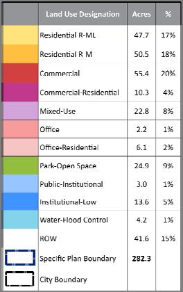
4 Other Updates Schweitzer Skate Park Westgate Proposed Schweitzer Skate Park Westgate site Google Earth image 7 Proposed Land Use Plan 9 4
5 Low Medium Residential Is intended to provide an attractive, healthy, and safe environment for attached singlefamily and multiple family units as either condominiums or apartments. Allows for a range of housing types, including attached single family townhouses, duplex or triplex buildings, and courtyard housing, and mobile home parks up to 18 dwelling units per acre. 10 Low Medium Residential DEVELOPMENT Low Medium Residential DU/AC Height 40 Limit 1 3 Stories Min. Front Setback 15 Min. Rear Setback 10 Parking Standard Per City Code 11 5


6 Low Medium Residential Low Medium Residential Minimum 15 front setback to be landscaped and may include open fencing, or a combination of solid and open fencing up to 5 There must be direct pedestrian access to the project from Beach Boulevard 12 Medium Residential Is intended to provide for quality, welldesigned multifamily living environments, as either condominiums or apartments, near transit and other services. This designation allows for a variety of housing types, including townhomes, courtyard housing, and stacked flats up to 36 dwelling units per acre. 13 6
7 Medium Residential DEVELOPMENT Medium Residential DU/AC Height 40 Limit 2 3 Stories Min. Front Setback 10 Min. Rear Setback 15 Parking Standard Per City Code 14 Medium Residential Medium Residential If adjacent to single family zone, one of the following options will apply to rear setback: Windows, balconies or similar openings will be oriented so as not to have a direct line of sight into adjacent units or onto private patios or backyards adjoining the property line The third floor will be stepped back by a minimum of 10 feet 15 7
8 Mixed Use Provides for a mix of uses including residential, commercial, services, hotel, and professional office uses in a high quality environment. Focus is on creating a pedestrian friendly environment, including increased connectivity and community gathering spaces. Uses and activities are designed together in an integrated fashion to create a dynamic urban environment. Continuous commercial street frontage on the first and, perhaps, second floors, supported by residential and/or office uses above, is the typical pattern of vertically mixed land use. 16 Mixed Use Uses may also be mixed in a horizontal or multi use pattern. Stand alone uses within a multi use project need to be integrated into an overall project design and connected to other adjoining uses by plazas, promenades, and landscaped corridors, and should include common architectural themes and signage. Typical residential uses could include stacked flats, live work units, townhouses, and artiststyle lofts. Residential development in these areas emphasizes quality and offers a variety of amenities. 17 8
9 Mixed Use DEVELOPMENT Mixed Use DU/AC *Projects over 2 acres in size will require a mix of uses Height 55 Limit 2 4 Stories Min. Front Setback 10 Min.: 25 Max. Min. Rear Setback 15 Parking Standard Per City Code, reductions for mixed use permitted by parking study 18 Mixed Use Mixed Use If adjacent to single family zone, one of the following options will apply to rear setback: Windows, balconies or similar openings will be oriented so as not to have a direct line of sight into adjacent units or onto private patios or backyards adjoining the property line The third floor will be stepped back by a minimum of 10 feet Sites with multiple buildings will be clustered to the extent possible with shared outdoor spaces and direct pedestrian access between uses and from parking areas 19 9
10 Mixed Use Mixed Use Outdoor dining must be separated from the sidewalk with either a low fence or wall, be incorporated into a courtyard, or be located on a terrace Buildings will be oriented to the street Surface commercial parking will be located to the side or rear of a building. Parking areas abutting streets will be screened by a buffer consisting of earth mounding, landscaping, low decorative walls, or combination 20 Commercial Is generally located at the major intersections and is intended to provide for the daily shopping, dining, and service commercial needs of the residents and business community in the area. Also allows for large scale commercial uses, entertainment, and commercial recreation uses that also serve the local tourism market. Allowed uses include grocery stores, specialty shops, restaurants, coffee houses, theatre, home goods stores, and a range of services. Projects should be designed to encourage pedestrian use by providing good connectivity within and to the site, with buildings clustered and close to the street
11 Commercial DEVELOPMENT Height Commercial 45 Limit Min. Front Setback 5 Min., 20 Max. (for 60% of the primary property frontage along Beach Blvd) Min. Rear Setback Parking Standard 25 Min.: No Max. 4 spaces/1,000 square feet includes restaurants up 40% of total gross floor area 22 Commercial Commercial Outdoor dining must be separated from the sidewalk with either a low fence or wall, be incorporated into a courtyard, or be located on a terrace If adjacent to SF Zone, max height limit is 2 stories or 28 within 30 of property line Sites with multiple buildings will be clustered to the extent possible with shared outdoor spaces and direct pedestrian access between uses, from parking areas, and from the street 23 11

12 Commercial Commercial Buildings will be oriented to the street Parking will be located to the side or rear of a building. Parking areas abutting streets will be screened by a buffer consisting of earth mounding, landscaping, low decorative walls, or combination 24 Commercial Residential Is intended to allow flexibility in zoning for parcels that could transition from commercial uses to residential or a mix of residential and commercial development. The designation will continue to allow for a range of community serving retail and service commercial uses. Also allows residential in either a standalone or mixed use configuration up to 36 dwelling units per acre, subject to the same standards as the Medium Residential zone
13 Commercial Residential DEVELOPMENT Commercial Residential Commercial: Residential: DU/AC N/A Height 35 Limit 2 3 Stories 40 Limit 2 3 Stories Min. Front Setback Min. Rear Setback Parking Standard 5 Min., 20 Max. (for 60% of the primary property frontage along Beach Blvd) 10 Min., 20 Max. 15 Min.: No Max. 4 spaces/1,000 Per City Code square feet includes restaurants up 40% of total gross floor area 26 Commercial Residential Commercial Residential Same setback requirements as the Medium Residential and Mixed Use zones when development it proposed adjacent to single family homes Same outdoor dining separation requirements as Mixed Use Same clustered development and building orientation requirements as Mixed Use 27 13

14 Commercial Residential Commercial Residential Site planning will accommodate access to/from commercial development on adjoining properties to the extent feasible Commercial parking will be located to the side or rear of a building. Parking areas abutting streets will be screened by a buffer consisting of earth mounding, landscaping, low decorative walls, or combination Driveway access into the site will be shared with adjoining non residentially zoned properties wherever feasible 28 Office Allows for a variety of small scale office uses, including legal services, insurance services, real estate, and medical or dental offices and other support services
15 Office DEVELOPMENT Office Height 40 Limit 2 3 Stories Min. Front Setback 5 Min., 20 Max. (for 60% of the primary property Min. Rear Setback Parking Standard frontage along Beach Blvd) 15 Min., No Max. Per City Code 30 Office Office If adjacent to single family zone, one of the following options will apply to rear setback: Windows, balconies or similar openings will be oriented so as not to have a direct line of sight into adjacent units or onto private patios or backyards adjoining the property line The third floor will be stepped back by a minimum of 10 feet 31 15
16 Office Residential Is intended to allow flexibility in zoning for parcels that could transition from medical office uses to residential development. Office designation will allow the medical office use to remain. The residential component allows property owners to redevelop the area for a range of multi family residential housing types, including courtyard housing, townhomes, and stacked flats up to 60 dwelling units per acre. Any new development will be required to upgrade the façade of the existing parking structure, if is proposed to remain. 32 Office Residential DEVELOPMENT Office Residential Office: Residential: DU/AC N/A Height 55 Limit 2 4 Stories with 3 stories max. within 100 of SF Zone Min. Front Setback 5 Min.: 20 Max. (for 60% of the primary property frontage along Beach Blvd) 10 Min.: 25 Max. Min. Rear Setback 15 Min.: No Max. Parking Standard Per City Code Per City Code 33 16
17 Office Residential Office Residential Same SF adjacent requirements as Office use Office parking will be located to the side or rear of a building. Parking areas abutting streets will be screened by a buffer consisting of earth mounding, landscaping, low decorative walls, or combination Driveway access into the site will be shared with adjoining non residentially zoned properties wherever feasible. 34 Office Residential Office Residential Parking structures will be architecturally integrated with the project design, and will be screened from view at street level by architectural detailing, façade treatment, artwork, landscaping or similar visual features to enhance the street façade


18 Other Uses Park Open Space: provides for active and passive public park and open space areas including Twila Reid and Schweitzer Park. It includes ancillary public buildings and facilities, such as a fire station and small recreation buildings. Institutional Low: is intended to accommodate the hospital, nursing home, assisted living facilities, as well as medical related uses in a clustered activity center to support the health care needs of West Anaheim and the surrounding area. Public: Provides for public facilities, such as the West Anaheim Youth Center. Water: Designation for the flood control channel. 36 Public Comment 10 Minutes 37 18
19 Administration and Next Steps Next Meeting: Wednesday, June 29 th 6:30 to 8:30 p.m. West Anaheim Youth Center Mark Your Calendar! Planning Commission Workshop Monday, June 13, pm City Council Chambers 200 S. Anaheim Blvd
Project Team. Community Workshop Draft Specific Plan Review West Anaheim Youth Center September 4, /6/2018.
 Community Workshop Draft Specific Plan Review West Anaheim Youth Center September 4, 2018 Project Team City: David Belmer Planning and Building Director Susan Kim, AICP Principal Planner Gustavo Gonzalez,
PLANNING COMMISSION. Study Session: Beach Boulevard Specific Plan Workshop
 PLANNING COMMISSION Study Session: Beach Boulevard Specific Plan Workshop Project Background Sustainable Communities Grant Funding Phase 1 Outreach: Improve the Boulevard A Specific Plan is a long-term
City Avenue District Rezoning. Regional Center Area & Bala Cynwyd Retail District December 14, 2011 Public Hearing
 City Avenue District Rezoning Regional Center Area & Bala Cynwyd Retail District December 14, 2011 Public Hearing Board of Commissioners Agenda Public Hearings An Ordinance to create The City Avenue District,
UPDATE Board of Selectmen June 20, 2017
 MAPLE STREET I-1 AREA DRAFT ZONING BYLAW & DEVELOPMENT STANDARDS Town of Danvers, MA UPDATE Board of Selectmen June 20, 2017 The Danvers Team: Brovitz Community Planning & Design Dodson & Flinker Danvers
VILLAGE CENTER ARLINGTON, VIRGINIA ADVISORY WORKING GROUP/ PLANNING COMMISSION FOR ORR PARTNERS 01/
 VILLAGE CENTER ADVISORY WORKING GROUP/ PLANNING COMMISSION FOR ORR PARTNERS 01/21 PROJECT BACKGROUND 01 PAGE 02 01. PROJECT BACKGROUND 1 EXISTING CONDITIONS SITE 1 STREET VIEW 2 2 STREET VIEW PAGE 03 01.
Chapter DOWNTOWN ZONING DISTRICTS
 Chapter 20.14 Sections: 20.14.010 Purpose of the Downtown Zoning Districts 20.14.020 Land Use Regulations for Downtown Zoning Districts 20.14.030 Development Standards for Downtown Zoning Districts 20.14.010
PLANNING ANALYSIS ZONING CASE 18-TOD-Z-026 NAK S CROSSING PUD AMENDMENT. GC-3-A (General Commercial) GC-3-A (General Commercial)
 GC-3-A (General Commercial)") PLANNING ANALYSIS ZONING CASE 18-TOD-Z-026 NAK S CROSSING PUD AMENDMENT GENERAL INFORMATION Applicant/Owner: Current Zoning: Bruce Nakfoor PUD/TOD (Planned Unit Development/Transit Oriented Development
PLANNING ANALYSIS ZONING CASE 18-TOD-Z-026 NAK S CROSSING PUD AMENDMENT GENERAL INFORMATION Applicant/Owner: Current Zoning: Bruce Nakfoor PUD/TOD (Planned Unit Development/Transit Oriented Development
12, 14, 16 and 18 Marquette Avenue and 7 Carhartt Street Zoning By-law Amendment Application - Preliminary Report
 STAFF REPORT ACTION REQUIRED 12, 14, 16 and 18 Marquette Avenue and 7 Carhartt Street Zoning By-law Amendment Application - Preliminary Report Date: July 17, 2014 To: From: Wards: Reference Number: North
Plan Dutch Village Road
 Plan Dutch Village Road Objective: The lands around Dutch Village Road are a minor commercial area that services the larger Fairview community. Maintaining the vibrancy of the area by planning for redevelopment
DRAFT ZONING BY-LAW AMENDMENT 75 DUBLIN STREET NORTH ZC1612
 DRAFT ZONING BY-LAW AMENDMENT 75 DUBLIN STREET NORTH ZC1612 Additions to the Draft Downtown Zoning By-law D.2 zone presented to Council at a public meeting on September 12, 2016 are displayed in a text
CITY OF NAPLES STAFF REPORT
 Meeting of 05/13/15 Conditional Use Petition 15-CU3 CITY OF NAPLES STAFF REPORT To: Planning Advisory Board From: Planning Department Subject: Conditional Use Petition 15-CU3 Petitioner: Hazelden Betty
1. ADOPTION OF THE AGENDA THAT the Commission adopts the agenda for the January 17, 2018 meeting of the Advisory Planning Commission.
 Agenda for the 2:00 pm Wednesday, January 17, 2018 Town of Qualicum Beach Advisory Planning Commission Special Meeting to be held in the Council Chambers, Municipal Office, 660 Primrose Street, Qualicum
Town Center Joint Commission Public Hearing #1: January 20, 2016
 Town Center Joint Commission Public Hearing #1: January 20, 2016 PROCESS PUBLIC HEARINGS Hearing 1 January 20 - Vision - Building height - Affordable Housing - Setbacks and massing Hearing 2 March 9 -
The Cannery Marketplace Narrative. Purpose: Site Design Approach: Cannery Commerce District 10/18/2017
 The Cannery Marketplace Narrative Cannery Commerce District 10/18/2017 Purpose: A number of entitlements are being requested for the Cannery Marketplace inclusive of a Master Conditional Use Permit (Master
Wilson Bridge Corridor Zoning. Department of Planning & Building
 Wilson Bridge Corridor Zoning Department of Planning & Building Background: Wilson Bridge Road Corridor Study The City conducted a strategic study of one of the community s primary economic centers, the
Figure 5-1, Land Use Plan, establishes the boundaries of each land use districts in the Boronda Community
 APPENDIX A DEVELOPMENT STANDARDS This Appendix provides development standards and regulations for the majority of the land use districts within the Community of Boronda. This section describes the allowed
WALNUT CREEK DESIGN REVIEW COMMISSION STAFF REPORT. AGENDA: July 6, 2016 ITEM 4b.
 WALNUT CREEK DESIGN REVIEW COMMISSION STAFF REPORT Attachment 3 AGENDA: July 6, 2016 ITEM 4b. ORIGINATED BY: COMMUNITY AND ECONOMIC DEVELOPMENT DEPARTMENT PLANNING PROJECT NAME APPLICATION TYPE APPLICATION
Oak Cliff Gateway District PD 468
 Oak Cliff Gateway District PD 468 August 21, 2014 2013 Authorized Hearing Authorized Hearing September, 2013 September 12, 2013 City Plan Commission expanded boundaries to represent current Oak Cliff Gateway
Crenshaw/LAX Transit Project Joint Development Fairview Heights Community Workshop #2 April 30, 2016
 Crenshaw/LAX Transit Project Joint Development Fairview Heights Community Workshop #2 April 30, 2016 1 Agenda 1. Introduction 2. What is Joint Development? 3. Community Input Process 4. What We ve Heard
COMMISSION ACTION FORM SUBJECT: ZONING TEXT AMENDMENT FOR LINCOLN WAY CORRIDOR PLAN DOWNTOWN GATEWAY COMMERCIAL ZONING DISTRICT STANDARDS
 ITEM #: 7 DATE: _02-07-18 COMMISSION ACTION FORM SUBJECT: ZONING TEXT AMENDMENT FOR LINCOLN WAY CORRIDOR PLAN DOWNTOWN GATEWAY COMMERCIAL ZONING DISTRICT STANDARDS BACKGROUND: The Downtown Gateway area
DEVELOPMENT DEPARTMENT STAFF REPORT THE PARK AT 5 TH
 DEVELOPMENT DEPARTMENT STAFF REPORT ARB Meeting Date: July 3, 2018 Item #: _PZ2018-293_ THE PARK AT 5 TH Request: Site Address: Project Name: Parcel Number: Applicant: Proposed Development: Current Zoning:
Sherwood Forest (Trinity) Housing Corporation. Urban Design Brief
 Housing Corporation. Urban Design Brief") Sherwood Forest (Trinity) Housing Corporation Sherwood Place Affordable Housing Apartments Trinity Presbyterian Church Orchard Park Nursery School 590 Gainsborough Road, London Urban Design Brief REVISED
Sherwood Forest (Trinity) Housing Corporation Sherwood Place Affordable Housing Apartments Trinity Presbyterian Church Orchard Park Nursery School 590 Gainsborough Road, London Urban Design Brief REVISED
Chapter MIXED USE ZONING DISTRICTS
 Page 1 of 12 Page 1/12 Chapter 17.18 MIXED USE ZONING DISTRICTS Sections: 17.18.010 Purposes. 17.18.020 Permitted, conditional and prohibited uses. 17.18.030 Bulk, 17.18.010 Purposes. A. Mixed Use Districts.
PARRAMORE OAKS FRAMEWORK PLANNED DEVELOPMENT
 PARRAMORE OAKS FRAMEWORK PLANNED DEVELOPMENT Presented by Mark Cechman, AICP Paul S. Lewis, FAICP Review Process Pre- Application meeting August 11, 2016 Attended by representatives of: City Planning Transportation
Part 4.0 DEVELOPMENT REGULATIONS
 M A I N S T R E E T N O R T H Part 4.0 DEVELOPMENT REGULATIONS 4.1 Districts 4.2 Permitted and Prohibited Uses, Standards and Standard Specific Criteria and Other General Provisions 4.3 DPS REGULATIONS
The Town of Parker, Colorado
 August 14th, 2017 Development Design Standards commercial, industrial, and mixed-use The Town of Parker, Colorado 2017 URBAN DESIGN ASSOCIATES Where we are in the process: Tasks 1 & 2: Listening and Understanding
1. Cuyler-Brownsville planned neighborhood conservation (P-N-C) districtphase I (section ). (2) Single-family semiattached dwellings;
 districtphase I (section ). (2) Single-family semiattached dwellings;") Sec. 8-3035. Planned unit development multifamily (PUD-M). A. Purpose. The PUD-M district is intended to allow a variety of residential development including single-family residential, two-family residential,
Sec. 8-3035. Planned unit development multifamily (PUD-M). A. Purpose. The PUD-M district is intended to allow a variety of residential development including single-family residential, two-family residential,
TABLE OF CONTENTS. Chapters and Sections
 TABLE OF CONTENTS Chapters and Sections Chapter 9.02 Permits and Approvals [Addition]... 1 9.02.090 Administrative variances.... 1 Chapter [New]... 1 9.07.091 Purpose and Intent... 1 9.07.092 Applicability...
Agenda. Where are we in the process? Schedule Survey results Framework Plan Transportation Exercise. downtown kingsport master plan
 Agenda Where are we in the process? Schedule Survey results Framework Plan Transportation Exercise downtown kingsport master plan Where are we in the process? downtown kingsport master plan Schedule Draft
Attachment 5 - Ordinance 3154 Exhibit D (Revised for 9/15 Council Meeting) Page 1 of 7 Port Townsend Municipal Code. Chapter 17.18
 Page 1 of 7 Port Townsend Municipal Code. Chapter 17.18") Page 1 of 7 Page 1/7 Chapter 17.18 MIXED USE ZONING DISTRICTS Sections: 17.18.010 Purposes. 17.18.020 Permitted, conditional and prohibited uses. 17.18.030 Bulk, 17.18.010 Purposes. A. Mixed Use Districts.
Page 1 of 7 Page 1/7 Chapter 17.18 MIXED USE ZONING DISTRICTS Sections: 17.18.010 Purposes. 17.18.020 Permitted, conditional and prohibited uses. 17.18.030 Bulk, 17.18.010 Purposes. A. Mixed Use Districts.
4 DEVELOPMENT STANDARDS FOR
 4 DEVELOPMENT STANDARDS FOR RESIDENTIAL MIXED-USE PROJECTS This chapter presents standards for residential mixed-use projects in the Ashland-Cherryland Business District and the Castro Valley Central Business
PUBLIC NOTICE* Studies Requested: Parking analysis. Other Required Permits: Building Permit, Site Development Permit
 C I T Y O F T A C O M A Planning & Development Services Department 747 Market St, Rm 345 Tacoma, WA 98402 PUBLIC NOTICE* Date of Notification: 1/15/2019 Application Received: 12/03/2018 Application Complete:12/07/2018
8 TH STREET UPDATE & NEXT STEPS. January 6, 2016 Regroup meeting of PAB and LDC Economic Development Working Group
 8 TH STREET UPDATE & NEXT STEPS January 6, 2016 Regroup meeting of PAB and LDC Economic Development Working Group Agenda Welcome & Introductions Process Overview and Timeline 2011-2016 Proposed Direction:
ACCESSORY DWELLING UNITS IN THE SOUTHEAST SECTOR
 February 19, 2019 Staff Report to the Municipal Planning Board LDC2018-10020 Item #11 S U M M A R Y Applicant The City of Orlando ACCESSORY DWELLING UNITS IN THE SOUTHEAST SECTOR Applicant s Request Update
From Policy to Reality
 From Policy to Reality Updated ^ Model Ordinances for Sustainable Development 2000 Environmental Quality Board 2008 Minnesota Pollution Control Agency Funded by a Minnesota Pollution Control Agency Sustainable
DEVELOPMENT DEPARTMENT STAFF REPORT STAFF REPORT EASTSIDE CHAMBLEE LINK DCI
 DEVELOPMENT DEPARTMENT STAFF REPORT Public Hearing Date: April 12, 2018 Item #: PZ-2018-248 STAFF REPORT EASTSIDE CHAMBLEE LINK DCI Request: Development of Community Compact (DCI), ten concurrent variances,
25 Leonard Avenue - Official Plan Amendment and Zoning Amendment Applications - Preliminary Report
 STAFF REPORT ACTION REQUIRED 25 Leonard Avenue - Official Plan Amendment and Zoning Amendment Applications - Preliminary Report Date: March 8, 2017 To: From: Wards: Reference Number: Toronto and East York
PLANNING COMMISSION MAY 3, 2018 PUBLIC HEARING
 PLANNING COMMISSION MAY 3, 2018 PUBLIC HEARING SUBJECT: REQUEST TO DEMOLISH TWO SINGLE-FAMILY DWELLINGS ON TWO ADJOINING LOTS AND CONSTRUCT TEN RESIDENTIAL CONDOMINIUM UNITS AT 947 GENESEE AVENUE AND 944
Goal 1 - Retain and enhance Cherry Creek North s unique physical character.
 Introduction This document summarizes the proposed new zoning for the area of roughly bordered by University Boulevard, Steele Street, 3rd Avenue, and 1st Avenue. It provides a high-level review of the
WELCOME! TO THE UNIVERSITY ENDOWMENT LANDS BLOCK F PUBLIC OPEN HOUSE
 WELCOME! TO THE UNIVERSITY ENDOWMENT LANDS BLOCK F PUBLIC OPEN HOUSE The UEL & Block F What is the UEL? Site Location The University Endowment Lands (UEL) is a separate jurisdiction from the City of Vancouver
APPENDIX D: DEFINITIONS
 D APPENDIX D: DEFINITIONS Terms used throughout the 2040 Comprehensive Plan should be interpreted using the definitions provided in this appendix. For interpretation of any term not defined, defer to the
Town of Clinton, Connecticut Action Plan for the Historic Unilever Property and Area. Steering Committee Meeting #5 Implementation Strategies
 Town of Clinton, Connecticut Action Plan for the Historic Unilever Property and Area Steering Committee Meeting #5 Implementation Strategies Wednesday, March 19, 2014 6:30pm Steering Committee Meeting
NORTHWEST QUADRANT NEIGHBORHOOD STUDY
 City of Novato General Plan 2035 Focus Area NORTHWEST QUADRANT NEIGHBORHOOD STUDY May, 2015 Why a Neighborhood Study? The Northwest Quadrant Neighborhood, north of the Grant Avenue business district,
CASTLES OF CALEDON URBAN DESIGN REPORT
 CASTLES OF CALEDON URBAN DESIGN REPORT PROPOSED RESIDENTIAL DEVELOPMENT CALEDON, ONTARIO 10 JULY, 2015 TABLE CONTENTS: 1.0 DEVELOPMENT 4.0 CONCLUSION 1.1 Introduction 1.2 Castles of Caledon- Urban Design
Multi-unit residential uses code
 9.3.11 Multi-unit residential uses code 9.3.11.1 Application (1) This code applies to assessable development identified as requiring assessment against the Multi-unit residential uses code by the tables
MONROE WARD REZONING SUMMARY. October 2018
 MONROE WARD REZONING SUMMARY October 2018 WHY IS THE CITY REZONING MONROE WARD? In July of 2017 Richmond City Council adopted The Pulse Corridor Plan, a corridor-long planning document that outlines steps
Evolution of the Vision for NE 181st Street Study Area
 City Council Action on NE 181 St Street Study Area Evolution of the Vision for NE 181st Street Study Area such uses to ensure neighborhood compatibility. More intense uses may be allowed through a conditional
TOWNHOUSE. TYPICAL UNIT SIZE 1,200 to 1,600 square foot average unit (two to three stories) DENSITY dwelling units/acre without cottages
 DENSITY dwelling units/acre without cottages") TOWNHOUSE Townhouses are typically two to three stories in height. Some townhouses include separate rental units, either on the top or bottom floor of a three-story townhouse unit, or in a cottage above
TOWNHOUSE Townhouses are typically two to three stories in height. Some townhouses include separate rental units, either on the top or bottom floor of a three-story townhouse unit, or in a cottage above
Rezoning Petition Pre-Hearing Staff Analysis April 17, 2017
 Rezoning Petition 2017-041 Pre-Hearing Staff Analysis April 17, 2017 REQUEST Current Zoning: R-5 (single family residential), R-22MF (multifamily residential), and I-1 (light industrial) Proposed Zoning:
UDO Advisory Committee Meeting #3 August 18, 2011
 UDO Advisory Committee Meeting #3 August 18, 2011 Today s s Agenda Welcome Recap of Meeting #2 Overview of Strategy Statement Overview of Zoning Districts What changes and what stays the same? Break Putting
LITTLE MOUNTAIN ADJACENT AREA REZONING POLICY
 LITTLE MOUNTAIN ADJACENT AREA REZONING POLICY JANUARY 2013 CONTENTS 1.0 INTENT & PRINCIPLES...1 2.0 APPLICATION...2 3.0 HOUSING TYPES, HEIGHT & DENSITY POLICIES...3 3.1 LOW TO MID-RISE APARTMENT POLICIES...4
DEVELOPMENT STANDARDS FOR RESIDENTIAL PROJECTS RESIDENTIAL BUILDING TYPES: APPROPRIATE ZONES AND DENSITIES 2-1
 2 DEVELOPMENT STANDARDS FOR RESIDENTIAL PROJECTS RESIDENTIAL BUILDING TYPES: APPROPRIATE ZONES AND DENSITIES 2-1 This Chapter presents the development standards for residential projects. Section 2.1 discusses
ARTICLE 5. COMMERCIAL AND OFFICE DISTRICTS 5.1 PURPOSE STATEMENTS 5.2 USES 5.3 DIMENSIONAL STANDARDS 5.4 DESIGN STANDARDS 5.5 DK DISTRICT STANDARDS 5
 ARTICLE 5. COMMERCIAL AND OFFICE DISTRICTS 5.1 PURPOSE STATEMENTS 5.2 USES 5.3 DIMENSIONAL STANDARDS 5.4 DESIGN STANDARDS 5.5 DK DISTRICT STANDARDS 5.6 CU DISTRICT STANDARDS 5.7 SW DISTRICT STANDARDS THE
4.2.8 Westwood/VA Hospital Station Area
 4.2.8 Westwood/VA Hospital Station Area The Westwood/VA Hospital Station area is north of the VA Hospital and surrounded by large, open landscaped areas and several parking lots. I-405 is a prominent visual
THE CORPORATION OF THE DISTRICT OF PEACHLAND BYLAW NUMBER 2065, A Bylaw to Amend Zoning Bylaw Number 1375, 1996
 THE CORPORATION OF THE DISTRICT OF PEACHLAND BYLAW NUMBER 2065, 2013 A Bylaw to Amend Zoning Bylaw Number 1375, 1996 WHEREAS the Council of the Corporation of the District of Peachland has adopted Zoning
Montreal Road District Secondary Plan [Amendment #127, October 9, 2013]
![Montreal Road District Secondary Plan [Amendment #127, October 9, 2013]](/thumbs/72/66783104.jpg "Montreal Road District Secondary Plan [Amendment #127, October 9, 2013]") [Amendment #127, October 9, 2013] 1.0 General The following policies are applicable to the Montreal Road District as set out in Schedule 1. 1.1 District Objectives The objective of this Plan is to guide
[Amendment #127, October 9, 2013] 1.0 General The following policies are applicable to the Montreal Road District as set out in Schedule 1. 1.1 District Objectives The objective of this Plan is to guide
Architectural Narrative Columbia & Hawthorn responds to its unique location as a gateway to Little Italy and the Bay in several ways. 1. The visual ch
 Architectural Narrative Columbia & Hawthorn responds to its unique location as a gateway to Little Italy and the Bay in several ways. 1. The visual character of the building is intended to symbolically
COMPLETE NEIGHBORHOODS AND HOUSING. Community Summit 02 February, 2012
 Lake Oswego Comprehensive Plan COMPLETE NEIGHBORHOODS AND HOUSING Community Summit 02 February, 2012 vision statement We have a wide variety of neighborhoods with high quality, attractive and compatible
COMMERCIAL ZONING DISTRICTS (Amended 11/13/14) Part I. C-1 Restricted Commercial District
 Part I. C-1 Restricted Commercial District") ARTICLE XI. COMMERCIAL ZONING DISTRICTS (Amended 11/13/14) Part I. C-1 Restricted Commercial District Section 152: Purpose This district is designed to accommodate commercial uses which act as a transition
ARTICLE XI. COMMERCIAL ZONING DISTRICTS (Amended 11/13/14) Part I. C-1 Restricted Commercial District Section 152: Purpose This district is designed to accommodate commercial uses which act as a transition
MEMORANDUM. C3A District Shoreland Overlay District 32,055 square feet / 0.74 acres. West Calhoun, adjacent to Cedar-Isles-Dean
 Department of Community Planning & Economic Development 250 South 4th Street, Room 300 Minneapolis, MN 55415-1385 MEMORANDUM To: City Planning Commission, Committee of the Whole Prepared By: Peter Crandall,
LILLIAN WEBB PARK DEVELOPMENT PROPOSAL. City of Norcross, Georgia 2034 Comprehensive Plan
 LILLIAN WEBB PARK DEVELOPMENT PROPOSAL City of Norcross, Georgia 2034 Comprehensive Plan AGENDA Overview: Zoning/Process: Market Studies: Design: Benefits: Bucky Johnson, Mayor John Bemis, DDA Chair Matt
Future Land Use Categories & Nodes December 23, Future Land Use Categories
 Future Land Use Categories & Nodes December 23, 2015 A note regarding nodes: Descriptions for nodes are located in the general recommendations handout. Node locations are set in part by the Auburn Interactive
DEVELOPMENT DEPARTMENT STAFF REPORT DRESDEN HEIGHTS PHASE II DCI
 DEVELOPMENT DEPARTMENT Meeting Date: January 10, 2019 Item #: PZ2019-393 Project Name: Applicant and Owner: Proposed Development: Requests: STAFF REPORT DRESDEN HEIGHTS PHASE II DCI Dresden Heights Phase
WALNUT CREEK DESIGN REVIEW COMMISSION STUDY SESSION STAFF REPORT
 WALNUT CREEK DESIGN REVIEW COMMISSION STUDY SESSION STAFF REPORT AGENDA: December 3, 2014 ORIGINATED BY: Community and Ecomic Development Department ITEM: 4d Day/Date/Time Place Project Name Application
PLANNING REPORT Gordon Street City of Guelph. Prepared on behalf of Ontario Inc. March 17, Project No. 1507
 PLANNING REPORT 1131 Gordon Street City of Guelph Prepared on behalf of 1876698 Ontario Inc. March 17, 2016 Project No. 1507 423 Woolwich Street, Suite 201, Guelph, Ontario, N1H 3X3 Phone (519) 836-7526
THE CITY COUNCIL OF NORTH ROYALTON, OHIO
 THE CITY COUNCIL OF NORTH ROYALTON, OHIO ORDINANCE NO. 16-113 INTRODUCED BY: Nickell, Kasaris, Antoskiewicz AN ORDINANCE AMENDING THE CODIFIED ORDINANCES OF THE CITY OF NORTH ROYALTON, PART 12 PLANNING
Article 3. SUBURBAN (S-) NEIGHBORHOOD CONTEXT
 NEIGHBORHOOD CONTEXT") Article 3. SUBURBAN (S-) NEIGHBORHOOD CONTEXT this page left intentionally blank Contents ARTICLE 3. SUBURBAN (S-) NEIGHBORHOOD CONTEXT DIVISION 3.1 NEIGHBORHOOD CONTEXT DESCRIPTION...3.1-1 Section 3.1.1
Article 3. SUBURBAN (S-) NEIGHBORHOOD CONTEXT this page left intentionally blank Contents ARTICLE 3. SUBURBAN (S-) NEIGHBORHOOD CONTEXT DIVISION 3.1 NEIGHBORHOOD CONTEXT DESCRIPTION...3.1-1 Section 3.1.1
Route 6 Corridor Study Bristol Planning Commission Meeting #1. May 25, 2016 FITZGERALD & HALLIDAY, INC. Innovative Planning, Better Communities
 Route 6 Corridor Study Bristol Planning Commission Meeting #1 May 25, 2016 FITZGERALD & HALLIDAY, INC. Innovative Planning, Better Communities Today s Agenda 1. Introductions 2. Study overview Scope Schedule
Introduction. General Development Standards
 Introduction The development standards will set the zoning regulations for the East Park development. This section will illustrate lot standards, approximate open space locations and road standards. The
Missing Middle Housing in Practice
 Missing Middle Housing in Practice Daniel Parolek Principal, Opticos Design, Inc. dan@opticosdesign.com New Partners for Smart Growth Kansas City, MO 2013 1 Bungalow Courts Missing MIddle Housing 2012
CITY OF LEBANON RUSSELL DRIVE AREA MIXED USE NEIGHBORHOOD CENTER FINAL IMPLEMENTATION PLAN
 CITY OF LEBANON RUSSELL DRIVE AREA MIXED USE NEIGHBORHOOD CENTER FINAL IMPLEMENTATION PLAN TGM Contract 2G-01 #22425 Deliverable 15.5 Prepared by: Satre Associates, P.C. Planners, Landscape Architects,
1202 & 1204 Avenue Road Zoning By-law Amendment Application - Preliminary Report
 STAFF REPORT ACTION REQUIRED 1202 & 1204 Avenue Road Zoning By-law Amendment Application - Preliminary Report Date: March 17, 2017 To: From: Wards: Reference Number: North York Community Council Director,
THE PEOPLE OF THE CITY OF LOS ANGELES DO HEREBY ORDAIN AS FOLLOWS:
 ORDINANCE NO. 184271 An ordinance amending Ordinance No. 173,749, the Vermont/Western Transit Oriented District Specific Plan (Station Neighborhood Area Plan) to create a new Subarea F. THE PEOPLE OF THE
VERTICAL MIXED USE DEVELOPMENT (Urban Village)
") VERTICAL MIXED USE DEVELOPMENT (Urban Village) Overall Goal Statement Vertical Mixed Use (Urban Villages) have similar goals to Horizontal Mixed Use except densities are usually higher and projects frequently
VERTICAL MIXED USE DEVELOPMENT (Urban Village) Overall Goal Statement Vertical Mixed Use (Urban Villages) have similar goals to Horizontal Mixed Use except densities are usually higher and projects frequently
DEVELOPMENT DEPARTMENT STAFF REPORT STAFF REPORT MCDONALD S ZONING MAP AMENDMENT AND CONCURRENT VARIANCES
 DEVELOPMENT DEPARTMENT STAFF REPORT Meeting Date: October 12, 2017 Item #: _PZ2017-172_ STAFF REPORT MCDONALD S ZONING MAP AMENDMENT AND CONCURRENT VARIANCES Request: Rezone property from MU-BC to CC,
Bunker Hill Part II Urban Design. Specific Plan. Case No. CPC SP TABLE OF CONTENTS
 Bunker Hill Part II Urban Design Specific Plan Case No. CPC-2011-684-SP TABLE OF CONTENTS Section 1. Section 2. Section 3. Section 4. Section 5. Section 6. Section 7. Section 8. Section 9. Section 10.
PLANNING AND REGULATING HOUSING OPTIONS FOR CHANGING DEMOGRAPHICS
 PLANNING AND REGULATING HOUSING OPTIONS FOR CHANGING DEMOGRAPHICS New Partners for Smart Growth Conference February 2017 HOUSING MARKETS Significant increase in rental housing Offset robust single-family
MEADOWBROOK FLATS SPECIAL USE PERMIT APPLICATION
 MEADOWBROOK FLATS SPECIAL USE PERMIT APPLICATION March 26, 2013 Submitted by: Bluestone Land, L.L.C. William N. Park, Manager 1821 Avon St. Suite 200 Charlottesville VA 22902 434-979-2900 wpark@pinnacleconstructionva.com
1999 Town Center West Proposal
 Crescent Square June 10, 2014 Page 2 1999 Town Center West Proposal Food-4- Less Retail Not a Part On June 10, 2004, the City Council and Planning Commission conducted a joint workshop to review conceptual
Bylaw No , being "Official Community Plan Bylaw, 2016" Schedule "A" DRAFT
 Bylaw No. 2600-2016, being "Official Community Plan Bylaw, 2016" Schedule "A" Urban Structure + Growth Plan Urban Structure Land use and growth management are among the most powerful policy tools at the
GNV RISE Subdivision. GNV RISE Subdivision
 GNV RISE Subdivision GNV RISE Subdivision A. Purpose and intent. 1. The purpose of this section is to provide a framework of adaptable incentive-based subdivision design standards which are intended to
Truax Park Apartments
 Truax Park Apartments Master Planning and Site Development Study Prepared by The Community Development Authority of the City of Madison In association with SMITH & SMITH ASSOCIATES, Inc CONSTRUCTION COST
RESIDENTIAL DISTRICTS
 RESIDENTIAL DISTRICTS RESIDENTIAL DISTRICTS The residential district standards have been revised to reflect on-the-ground development conditions, while continuing to respect the use patterns established
4.2 RESIDENTIAL ZONING DISTRICTS
 4.2 RESIDENTIAL ZONING DISTRICTS A. Purpose: To define regulations and standards for each residential zoning district in the City. The following sections identify uses, regulations, and performance standards
COMMERCIAL ELEMENT AND CODE ENFORCEMENT
 COMMERCIAL ELEMENT AND CODE ENFORCEMENT The Commercial Element identifies and describes the existing characteristics that are desired by the neighborhood. The existing conditions will determine appropriate
Overview. Central Street Master Plan. Appendix B: Zoning
 Central Street Master Plan Overview The City of Evanston has 36 zoning districts, of which 11 are found in the Central Street Corridor Study Area (See Figures B.1 and B.2). They include: R1: Single-Family
DTLA RETAIL OR RESTAURANT FOR LEASE Adjacent to Fashion District & Arts District E WASHINGTON BLVD, LOS ANGELES, CA Offering Memorandum
 DTLA RETAIL OR RESTAURANT FOR LEASE Adjacent to Fashion District Arts District 1225 E BLVD, LOS ANGELES, CA 90021 Offering Memorandum Retail Store or Restaurant For Lease 2,200± SF Available 1225 E Washington
Community Mixed Use Zone Districts (CMU)
") 18.28.500 Community Mixed Use Zone Districts (CMU) The Community Mixed Use Zone Districts (CMU) are intended to help implement the land use goals and strategies found in the Golden Vision 2030 values,
18.28.500 Community Mixed Use Zone Districts (CMU) The Community Mixed Use Zone Districts (CMU) are intended to help implement the land use goals and strategies found in the Golden Vision 2030 values,
2.0 LAND USE FRAMEWORK
 Land Use Framework 2.0 LAND USE FRAMEWORK FOLSOM BOULEVARD 2.1 LAND USE OVERVIEW The proposed land uses for Easton Place offer local and regional employment, shopping, and entertainment, highlighting the
Kassner Goodspeed Architects Ltd.
 Kassner Goodspeed Architects Ltd. 29 & State Street Developments Ltd. The Promenade at Robie South Case 20761: Application for Development Agreement Design Rationale The land assembly is a 1.3 Acre parcel
ARTICLE 3: Zone Districts
 ARTICLE 3: Zone Districts... 3-1 17.3.1: General...3-1 17.3.1.1: Purpose and Intent... 3-1 17.3.2: Districts and Maps...3-1 17.3.2.1: Applicability... 3-1 17.3.2.2: Creation of Districts... 3-1 17.3.2.3:
Composition of traditional residential corridors.
 Page 1 of 7 St. Petersburg, Florida, Code of Ordinances >> PART II - ST. PETERSBURG CITY CODE >> Chapter 16 - LAND DEVELOPMENT REGULATIONS >> SECTION 16.20.060. CORRIDOR RESIDENTIAL TRADITIONAL DISTRICTS
ARTICLE 3: RESIDENTIAL DISTRICTS
 ARTICLE 3: RESIDENTIAL DISTRICTS SECTION 2.3.010 DISTRICTS 1) Purpose Roseburg s residential Zoning Districts are primarily intended to create, maintain and promote a variety of housing opportunities for
Downtown Development Focus Area: I. Existing Conditions
 Downtown Development Focus Area: I. Existing Conditions The Downtown Development Focus Area is situated along Route 1, south of the train tracks, except for the existing Unilever property. It extends west
Address: 2025 Agassiz Road Applicant: Cristian Anca. RM5 Medium Density Multiple Housing
 REPORT TO COUNCIL Date: February 20, 2017 RIM No. 1250-30 To: From: City Manager Community Planning Department (TB) Application: Z16-0052 Owner: Exceling Investments Inc. No. BC1062096 Address: 2025 Agassiz
1. Multi-family dwellings, including town homes, apartments, or condominiums.
 Sec. 4-6.67 Planned Unit Development (PUD-M). a. Definition. A planned multi-family zoning district of three acres or more, consisting of townhouses, apartments, condominiums, single-family detached, single-family
BYLAW NO. 15/026 A BYLAW OF THE REGIONAL MUNICIPALITY OF WOOD BUFFALO TO AMEND THE LAND USE BYLAW NO. 99/059
 Attachment 2 BYLAW NO. 15/026 A BYLAW OF THE REGIONAL MUNICIPALITY OF WOOD BUFFALO TO AMEND THE LAND USE BYLAW NO. 99/059 WHEREAS Section 639 of the Municipal Government Act requires every municipality
EAST WEST PARTNERS SCOTT MURRAY LAND PLANNING, INC.
 WhyMixedUse? Trac Combiningresidentialdwellingswith workplace,shoppingandentertainmentcommercial developmentreducestheuseofautomobilesand encouragestheuseofalternativemethodsof transportation,includingpedestrian,bicycleandpublic
PREPARED FOR: ADI DEVELOPMENT GROUP INC.
 Acronym Urban Design and Planning/Mark Sterling Consulting Inc. 111 Clendenan Avenue, Toronto, Ontario M6P 2W7 URBAN DESIGN BRIEF PROPOSED DEVELOPMENT 4880 VALERA ROAD, CITY OF BURLINGTON PREPARED FOR:
Permitted uses. Adult congregate living facility. Ambulance service. Animal clinics (outpatient care only and no overnight boarding)
") B-3, HIGHWAY SERVICE BUSINESS DISTRICT Intent. The B-3, Highway Service Business District is intended for application along highways carrying large volumes of traffic where establishments may locate to
B-3, HIGHWAY SERVICE BUSINESS DISTRICT Intent. The B-3, Highway Service Business District is intended for application along highways carrying large volumes of traffic where establishments may locate to