PLANNING DIVISION STAFF REPORT LU APPLICANTS/PROPERTY OWNERS Harold and Pamela Arkin, Trustees Marlin Properties, LLC Esta Rubinstein Trust
|
|
|
- Stuart Barton
- 6 years ago
- Views:
Transcription

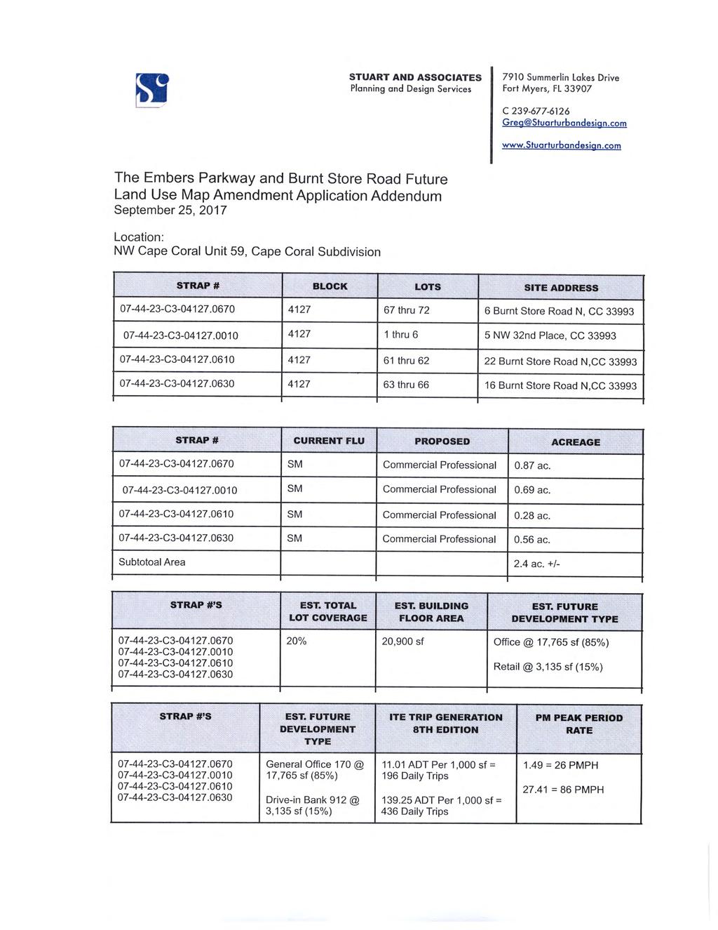
1 PLANNING DIVISION STAFF REPORT LU PROPERTY ADDRESSES 6 Burnt Store Road 16 Burnt Store Road 22 Burnt Store Road 5 NW 32 nd Place APPLICANTS/PROPERTY OWNERS Harold and Pamela Arkin, Trustees Marlin Properties, LLC Esta Rubinstein Trust SUMMARY OF REQUEST The applicants propose a Future Land Use Map Amendment for four undeveloped sites (2.4 acres) from Single-Family/Multi-Family (SM) to Commercial/Professional (CP). The existing zoning is Residential Development (RD). MAP SOURCE STAFF RECOMMENDATION: APPROVAL Positive Aspects of Application: Negative Aspects of Application: Mitigating Factors: Provides additional commercial land at an existing intersection of two arterial roads. The block is sparsely developed with single-family homes to the north. This area will receive City water, sewer, and irrigation within 1-3 years. There is no existing commercial development in the block to integrate with. One single-family home is adjacent to the site. The site has frontage along a principal arterial. Burnt Store Road has access management plan to encourage cohesive development.
2 November 15, 2017 LU Page 2 Site Information Urban Service Area: All sites are in the Transition Urban Service Area, except for 16 Burnt Store Road which is in the Reserve Urban Service Area. City Water and Sewer: Street Access: The area is not currently serviced by City water and sewer, however, the site is in the North 2 (N2) Utility Expansion Project Area, which has begun installation of utilities. The site has access from three streets: Burnt Store Road, Embers Parkway, and NW 32 nd Place 1. STRAP Number: 6 Burnt Store Road C Burnt Store Road C Burnt Store Road C NW 32 nd Place C Block/Lot(s): The site is in Block 4127/Lots 1-6 and Zoning and Land Use Information: Subject Property: Future Land Use Zoning Current: Single-Family/Multi-Family Residential (SM) Residential Development (RD) Proposed: Commercial/Professional (CP) N/A Surrounding Areas Future Land Use Zoning North: SM RD South: Single-Family Residential (SF) Single-Family Residential (R-1B) East: SM RD West: SF R-1B 1 A Principal Arterial, Minor Arterial, and Local street, respectively.
3 November 15, 2017 LU Page 3 Background The 2.4 acre site is an undeveloped assemblage of parcels in the northwestern quadrant of the City. The site is at the intersection of Embers Parkway and Burnt Store Road and bisected by an unimproved 20-foot wide alley right-of-way (ROW). Surrounding development consists of undeveloped parcels and single-family homes. City water and sewer are not available, however, the site is in the N2 section of the Utility Expansion Project (UEP) which is currently under construction. There is no existing access, however, access from Embers Parkway and NW 32 nd Place is probable. Burnt Store Road is a controlled access road and under the jurisdiction of the Lee County Department of Transportation (LCDOT). Ingress and egress from Burnt Store Road would need approval from LCDOT. The site has a Future Land Use Map classification of SM which has been present since 1989, upon adoption of the Comprehensive Plan and the Future Land Use Map. There have been no Future Land Use Map amendments in the block. There have been Future Land Use Map amendments in the vicinity in the past 10 years. Several properties to the east across Burnt Store Road were amended to Commercial Activity Center (CAC) in In addition, properties to the west and south were recently amended to Single-Family Residential (SF) on October 29, The applicant states in their Letter of Intent that the properties are suited for commercial development based upon their location at a major intersection and they are part of the gateway into the future Seven Islands development along Old Burnt Store Road. Additional Site Information Protected Species The applicant has not performed a Protected Species Survey, however, the sites are clear of vegetation and no wetlands are present. The City requires species surveys prior to issuance of City of Cape Coral permits or development approvals, in accordance with the Conservation and Coastal Management Element of the Comprehensive Plan. Should additional protected species be identified on the property as part of the development review of the site, the City will abide by Policy of the Conservation and Coastal Management Element, which states: Policy 1.2.5: The City will assist in the implementation of and compliance with all state and federal regulations concerning species listed as endangered, threatened, species of special concern, or commercially exploited by monitoring development activities, providing information on listed species in building permit packages, and assisting in investigations as requested. Soils and Drainage The site has one soil classification; Matlacha Gravelly Fine Sand. This soil has limitations for development, which are typically overcome using various engineering solutions such as importing fill. The soil type should not present an obstacle to future land development although special feasibility studies may be required.
4 November 15, 2017 LU Page 4 Analysis Comprehensive Plan Chapter 4 Future Land Use Element Policy 1.12 The Comprehensive Plan recognizes that the original platting of the City was prepared with the primary purpose of creating a readily marketable commodity; residential lots. This resulted in an imbalance between residential and commercial lands, leading to insufficient commercial land. As required by Policy 1.12 of the Future Land Use Element, the City conducted a citywide commercial needs study. This study identified the characteristics and locations for new potential commercial lands. Policy 1.12 of the Future Land Use Element requires the City to conduct commercial land needs studies to identify areas of the City, which could accommodate commercially designated land, consistent with the studies findings and recommendations, and other provisions of the Comprehensive Plan. In March 2007, the City of Cape Coral requested Paul Van Buskirk, PhD., AICP, PE, and Mike Jackson, the City s former Economic Development Director, to prepare a report entitled: Future Land Use Analysis: Commercial & Industrial Land Required For The City of Cape Coral At Build-Out. This report updated earlier analyses. The report suggests a number of strategies to increase the inventory of developable commercial properties within the City. Two of the suggested strategies involve 1) converting parcels with residential future land use to commercial future land use and, 2) increasing the size of existing commercial areas. The proposed amendment is seeking to convert parcels with a residential future land use to a commercial future land use. Therefore, staff finds that the proposed amendment is consistent with Policy Policy 1.13 Policy 1.13 encourage commercial development at commercial nodes to decrease the potential for strip development and to facilitate compact development that encourages pedestrian friendliness. A commercial node is defined as the intersection of two four-lane parkways or boulevards. Tropicana Parkway has four lanes and Burnt Store Road is currently being widened to four lanes, while also being designated as a Principal Arterial. This site qualifies as a commercial node, therefore, staff finds that the proposed amendment is consistent with Policy Policy 1.14 Policy 1.14 addresses eight commercial siting guidelines that provide guidance on whether or not a site is appropriate for a conversion from residential to commercial. The guidelines are also a guide on determining compatibility between existing residential uses and potential commercial uses. A response to each of the commercial siting guidelines follows in bold. Major Intersection Preferred locations for commercial properties are in the vicinity of major intersections (i.e., intersections of two or more arterial and/or collector roadways). Development of a commercial node at such an intersection may involve multiple parcels and, sometimes, multiple quadrants of the intersection. The benefits derived by having commercial properties located in the vicinity of the intersection diminish with distance, but the distance at which
5 November 15, 2017 LU Page 5 a property ceases to derive benefit from proximity to the intersection varies, based upon whether the subject property would represent a new commercial property (a commercial property not abutting any existing commercial properties) or an expansion of an existing commercial area. New commercial properties should preferably be located adjacent to the intersection, while commercial properties that clearly represent an expansion of an existing commercial area can be any distance from the intersection, provided that such properties are integrated with existing properties (see below: Integration). Staff Response: The sites are at a major intersection of a Principal Arterial and a Minor Arterial, therefore Planning staff finds that the sites are consistent with the above guideline. Adequate Depth Ideally, a commercial property should extend not only along the adjacent collector or arterial roadway, but also should extend inward with adequate depth to accommodate the necessary parking, buffering, retention, and open area for the future commercial development. In Cape Coral, most City blocks are rows of back-to-back lots approximately 250 feet deep. Preferably adequate depth is achieved if any number of contiguous properties, owned by the same landowner (see Ownership Pattern, below) occupy the entire 250 feet of depth. Adequate depth would not be achieved if the subject properties have different owners, and if the contiguous properties are not reasonably compact (see below, Compactness ). Staff Response: 50% of the total site area has the preferred depth of 250 feet along a major roadway. The sites that have full block depth are not occupied by the same landowner, however, they are both parties to the Future Land Use Map amendment request. Due to most of the site area possessing full block depth and the joint application by the owners, Planning staff finds that the sites are consistent with the above guideline. Compactness Compactness measures the ability of a property proposed for a commercial future land use to take advantage of economies of scale. The shape of an ideal compact commercial property approaches that of a square or rectangle. This quality allows for an orderly arrangement of development on the subject property and acts to reduce adverse visual, noise or aesthetic impacts to neighboring properties. Staff Response: 50% of the site area is reasonably compact in a quadrilateral or square-like shape. The remainder of the area has a rectangular shape, however, it does not possess full block depth as discussed in the previous guideline. Therefore, the sites are consistent with the above guideline. Integration Integration, for the purposes of these guidelines, refers to the interrelatedness of development within a commercial node or area. The presence of features, such as internal access roads, shared parking, courtyards, walkways, or other features, binds the various commercial properties within the node together. This pattern of development reduces the traffic impacts associated with commercial development and often promotes a pedestrian-friendly environment. Integration of neighboring commercial properties should always be encouraged. Therefore, properties proposed for conversion to a commercial future land use should be evaluated for the likelihood that such properties would or could be integrated with adjacent existing commercial properties.
6 November 15, 2017 LU Page 6 Staff Response: There are no other sites in Block 4127 that have commercial Future Land Use designation or zoning which eliminates the opportunity for integration between commercial developments. The closest area with a commercial or mixed-use Future Land Use or zoning designation is at the southeast intersection of Tropicana Parkway and Burnt Store Road. Due to the lack of existing commercial land in Block 4127, Planning staff finds that the sites are not consistent with the above guideline. Assembly For commercial areas to provide the most benefit to the surrounding community, they must be of relatively large size. The majority of buildable lots within the City of Cape Coral are approximately 10,000 square feet (0.23 acre) in size. These lots were designed primarily for single family residential development and do not typically have adequate width or depth for larger commercial development that might serve the City as shopping or employment centers. Therefore, it is important for the City to encourage commercial applicants to assemble relatively large parcels (properties comprising 3 acres or more). Assembly of pre-platted parcels into tracts of 3 acres or more will promote the development of commercial properties that do not express the indicators of strip commercial development. Assembly of larger parcels also allows the developer to provide a greater variety of commercial land uses, and to provide architectural and landscape features that result in a more attractive end-product. Properties proposed for conversion to a commercial future land use, where such properties would represent an expansion of an existing commercial area may be considered assembled, for the purposes of these guidelines if the proposed expansion properties are either owned by the landowner of one or more adjacent commercial properties, or if the expansion property is likely to be integrated with (see above) adjacent commercial properties. Staff Response: Collectively, the sites total 2.4 acres which is slightly less than the preferred size of three acres. The sites also lack cohesive ownership and there are not any other sites in Block 4127 with existing commercial development. Staff finds that the sites are partially consistent with this guideline. Intrusion Intrusion, as defined for the purpose of these guidelines, is a measure of the objectionable qualities of the proposed commercial development. This guideline applies primarily to new commercial property (a property proposed for conversion to a commercial future land use in an area where it would not abut existing commercial properties). Intrusion evaluates the potential adverse impacts on surrounding properties that could be caused by converting a property from its existing future land use to a commercial use. There are no definite guidelines for determining when a proposed commercial use would be intrusive to surrounding development. However, expansions of existing commercial areas are generally considered less intrusive than the establishment of new commercial areas. Commercial areas may be considered less intrusive to adjacent multi-family development than to adjacent single family development. Commercial development that is separated from a residential area by a street, canal, vegetative buffer, or other geographic features may be considered less intrusive than a commercial development that directly abuts a residential area. The degree of compactness (see Compactness above) of a commercial property can also reduce or increase its intrusion upon adjacent or nearby properties. Typically, new commercial properties 2 are less likely to be considered intrusive if the surrounding or adjacent 2 Properties proposed for conversion to a commercial future land use classification that do not abut existing commercial properties.
7 November 15, 2017 LU Page 7 residential areas are sparsely developed. While the finding of intrusion is subjective and depends on many factors, the principle is the proposed commercial property would not likely be intrusive if adjacent residential areas are 25% or less developed. The area analyzed to determine the percentage of adjacent residential development may vary from 300 feet to 1,000 feet from the subject property, depending upon the degree to which streets, canals, landscaping or other geographic features separate the subject property from nearby residential areas. Staff Response: The surrounding residential area within 1,000 feet of the sites is less than 25% developed. Therefore, the proposed CP Future Land Use Designation would not be considered intrusive. Staff finds that the sites are consistent with the above guideline. Access In the City of Cape Coral there are two ideal access provisions for a commercial property. If a subject property would meet the requirements for one or more of these provisions, the creation of a commercial future land use at the proposed location should be encouraged. These provisions are as follows: a) Access via a platted City parking area. The City of Cape Coral contains a number of dedicated commercial parking areas; some created by plat, and some deeded to the City by landowners. The Comprehensive Plan and City Land Use and Development Regulations refer to these as dedicated City parking areas. These parking areas are often surrounded by smaller platted lots originally intended for commercial development with access to these lots only, or primarily, from the dedicated City parking area. In implementing this provision, it may sometimes be in the City s interest to promote conversion of a dedicated City parking area to a fully functional commercial development (i.e., a portion of the dedicated parking area would become a commercial building site) in return for the applicant s agreement to own and manage the site. b) Direct access onto an arterial or collector roadway having an adopted City access management plan. The City has adopted access management plans for certain arterial and collector roadways. Access management plans serve to facilitate mobility of the traveling public; therefore, such roadways more readily accommodate the impacts of commercial development than roadways without such access management plans. Staff Response: As stated previously, the sites have frontage on Burnt Store Road, Tropicana Parkway and a local street. Neither of these streets have frontage roads, however, Burnt Store Road has a controlled access plan that is under the authority of Lee County. This access management plan limits driveway connections from Burnt Store Road to increase traffic flow and facilitate mobility. Planning staff finds that the sites are partially consistent with the above guideline. Ownership Pattern An ideal commercial node is a cohesive, compact, interrelated network of commercial properties. Properties proposed for conversion to a commercial future land use that consist of multiple parcels, or groups of parcels, or under multiple ownerships are unlikely to develop as a true commercial node. Instead, these properties are more likely to develop as separate, small commercial developments with multiple access points, leading to adverse, unsafe traffic conditions. Each small development may also have its own stormwater management pond, dumpster, and an appearance and/or landscaping design that is inconsistent with surrounding development. This pattern is a characteristic of strip commercial development (see Policy 1.13, above). Therefore, the City of Cape Coral encourages land owners and developers to assemble the properties involved in a commercial future land
8 November 15, 2017 LU Page 8 use request under common ownership. Multiple, small properties under separate ownership, even if such properties are included in a single future land use amendment request, may not be appropriate for the full array of commercial uses. Staff Response: The amendment area has five sites and three different owners. The largest area under one owner is As discussed in the guideline, multiple smaller properties under separate ownership may not result in large commercial developments. Staff finds that the sites are not consistent with the above guideline. In summary, Policy 1.14 contains eight commercial siting guidelines. The sites are consistent with four of these guidelines (Major Intersection, Adequate Depth, Compactness, and Intrusion), partially consistent with two guidelines (Assembly and Access) and is inconsistent with two guidelines (Integration and Ownership Pattern). Policy 1.14 does not require a proposed amendment to meet a certain threshold of guidelines, rather the guidelines are meant to provide a compatibility analysis. Based on these guidelines, Planning staff finds that the proposed should be compatible with the neighborhood and should provide an opportunity for commercial development at a major intersection. Policy 3.1 Policy 3.1 states that the City of Cape Coral will encourage commercial development at transportation nodes by designating areas with appropriate future land use categories. Planning staff finds that the proposed amendment is at a transportation node, therefore, this policy is supportive of the proposed amendment. Regional Plan Analysis Southwest Florida Regional Planning Council s (SWFRPC) Strategic Regional Policy Plan (SRPP): This amendment is consistent with the SRPP Strategy locating commercial development along transportation corridors. Lee County Metropolitan Planning Organization s (MPO) 2040 Long Range Transportation Plan: Burnt Store Road has been identified for improvements and widening in the MPO s 2040 Long Range Transportation Plan. Burnt Store Road is being widened to four lanes and will be utilized as an evacuation route in the event of impending natural disasters. Impact Assessment Summary The following calculations summarize approximate conditions for each municipal service analyzed. To determine the impact assessment, staff utilized the adopted future land use and zoning designations to determine the existing impacts at buildout. Therefore, the impacts discussed in this assessment do not necessarily reflect the actual number of dwelling units, population, etc. present within the subject area. The site is Single-Family/Multi-Family (SM), and the analysis assumes a residential density of 4.4 dwelling units per acre for the site. While the sites are currently undeveloped, the analysis must consider the potential impacts of the proposed Commercial/Professional (CP) land use in the event of construction. Historically, commercial development in Cape Coral has developed with a Floor Area Ration (FAR) of Therefore, 26,136 sq. ft. of commercial development on these sites is a reasonable estimate for analyzing the impacts of the proposed land use amendment.
9 November 15, 2017 LU Page 9 Dwelling Units Existing: 10 Proposed: 0 Net Change: -10 Population* Existing: 25.4 Proposed: 0 Net Change: * 2.54 persons/household = avg. household size; 2010 Census Water Use Existing: Proposed: Net Change: Facility Capacity: Permitted Usage: Avg. Daily Usage: 2,000 gal/day total (10 dwelling units x 200 gal/day) 7,841 gal/day total (26,136 square feet x 0.3 gal/sq ft/day) +5,841 gal/day 30.1 MGD 16.9 MGD 9.4 MGD Sewage Existing: Proposed: Net Change: Facility Capacity: Avg. Daily Usage: 2,000 gal/day total (10 dwelling units x 200 gal/day) 7,841 gal/day total (26,136 square feet x 0.3 gal/sq ft/day) +5,841 gal/day 28.4 MGD 12.8 MGD Solid Waste Existing Generation: Proposed: Net Change: Facility Capacity: Existing Demand: Capacity Available: 119 lbs. total/day (25 persons square feet x 4.74 lbs/person/day) 3,554 lbs. total/day (26,136 square feet x lbs/sq ft/day) +3,435 lbs/day 1,836 tons/day 1,384 tons/day Yes Traffic/Daily Trips Existing Generation: Proposed: 8 AM peak trips/hour and 10 PM peak trips/hour 27 AM peak trips/hour and 98 PM peak trips/hour
10 November 15, 2017 LU Page 10 Net Change: Facility Capacity: Capacity Available: 19 AM peak trips/hour and 88 PM peak trips/hour Both Burnt Store Road and Tropicana Parkway meet the minimum acceptable Level of Service Standard of D. Yes Development Impact Analysis Hurricane Evacuation The subject area is in Evacuation Zone A, however, this amendment would result in a reduction of dwelling units and a small decrease in evacuation times for the surrounding area. Park Lands The levels of service standard (LOS) for parkland and facilities are based on permanent population. The amendment would result in a reduction of dwelling units and would have no impact on parkland LOS. Protected Species The City requires an environmental survey prior to the issuance of any land clearing, site clearing, or development permits. Any future land alteration activities will be preceded by the completion of an environmental survey identifying the presence of protected flora and fauna. Based on the results of the environmental survey, City, state, or federal protective or mitigation measures may be required by the developer to proceed. School Impacts There will be no addition of housing units or population, therefore, no additional school impacts are anticipated. Recommendation: Planning Division staff finds that the proposed Future Land Use amendment is consistent with several policies of the Citys Comprehensive Plan and is compatible with the surrounding neighborhood and therefore recommends approval of the proposed small-scale future land use map amendment request. Planning Staff Contact Information Chad Boyko, AICP, Principal Planner /cboyko@capecoral.net
11
12

13

14

15


16 Regional Comprehensive Plan Analysis: The Strategic Regional Policy Plan (SRPP) Economic Development Goal One: "Ensure the adequacy of lands for commercial and industrial centers, with suitable services provided." Response: The land use map amendment provides needed commercial land inventory within the land use planning context of NW Cape Coral's overwhelming single-family residential platted lands inventory. Cape Coral Future Land Use Element Analysis: Policy 1.20: "The City will promote the development of identifiable residential and commercial districts through the encouragement of more compact development patterns, the use of shared design and landscaping characteristics, and the development of landmarks and gateways." Response: The land use map amendment consolidates four individual parcels into one unified property to facilitate a small and identifiable commercial project. The commercial project will serve as the non-residential Embers Parkway gateway, from Burnt Store Road to the pending Seven Islands mixed use project. Policy 3.1: "The City of Cape Coral will encourage the development of future commercial (retail, office and/or services) areas at or near transportation nodes by assigning appropriate future land use designations. " Response: The land use map amendment is for a 2.4 acre site located at the northwest quadrant of the intersection of Embers Parkway and Burnt Store Road. This intersection is identified on the Burnt Store Road South Phase as a full turning movement intersection for the four-lane Burnt Store Road segment. The property is ideally located for commercial land uses and supports viable transportation nodal planning. Policy 3.3: "Application of the commercial areas along and proximate to commercial corridors at key locations is intended to address the projected demand for commercial development as summarized in the Table below, or other subsequent analysis." Response: In the City's Land Use Element Policy 3.3 Commercial Centers by Corridor table, the City has identified 190 acres of land along Tropicana and Embers Parkway needed for commercial development. According the the City (see LU ; 04/27/17), at present approximately 90 acres along these roadways are identified as commercial. Therefore at present, a deficit of 100 acres exists. The requested 2.4 acre Commercial/Professional Land Use Map amendment provides needed commercial land inventory as identified by the City. Policy 3.4: " The City shall initiate and/or consider privately initiated future land use map amendments necessary to provide an adequate supply of lands designated for retail, office and service uses in quantities and locations appropriate for such uses, generally consistent with the findings of the Commercial Corridor Study, or other subsequent analysis. " Response: See the response to Policy 3.3; the map amendment is consistent with 3.4. Objective 4 Location of Future Development: "Future private development requiring public water and wastewater will be directed into the Urban Services Infill Area and the Urban Services Transition Area illustrated on the Future Land Use Map, unless specifically accepted by the provisions of this plan." STUARTANDASSOCIATES Planning and Design SerAces 5
17 Response: The subject property is in the Urban Services Transition Area; utilities will be extended into this area as part of the North 2 UEP, anticipated to begin in Policy 5.3: " New commercial development shall meet all of the requirements for adequate facilities based on the level of service standards adopted for roads, public water and sanitary sewer, solid waste, storm water facilities and other services in this plan." Response: The requested future land use map amendment will have available to it all needed urban services at acceptable levels, including central water and sanitary sewer service. Based upon the subject property's platted lot structure, it is reasonable to assume that the property can currently support nine single-family homes. The requested land use map amendment is expected to have 17, 765 sf general office and 3, 135 sf commercial bank (20,900 sf total). The elimination of nine dwelling units, assuming 2.54 persons per household, will lead to a supported population reduction of 23 persons. Specific service impact assessments are as follows -- Water Use_ Zero presently; existing@ 200 GPO * 9 units= 1,800 GPO; proposed commercial@ 20,900 sf x 0.3 gal/sf/day= 6,270 GPO; Net Change@+ 4,470 GPO (City permitted 16.9 MGD). Sanitary Sewer_ Zero presently; existing@ 00 GPO * 9 units= 1,800 GPO; proposed commercial@ 20,900 sf x 0.3 gal/sf/day= 6,270 GPO; Net Change@+ 4,470 GPO (City permitted 28.4 MGD). Solid Waste_ Zero presently; existing at 109 lbs./day (23 persons x lbs./person/day); proposed 20,900 sf x lbs/sf/day = 2,842 lbs/day; Net lbs./day (City Facility 1,836 tons/day with Existing 1,384 tons/day). Traffic Daily Trips_ Zero presently; 9 DUS x 9.57 ADT = 86 trips (9 PM Peak Hr.); proposed 17, 765 sf general office and 3, 135 sf commercial bank equals 195 ADT general office and 436 ADT commercial bank (631 total ADT); Net Change@ 545 ADT. Embers Parkway provides direct access to the subject property. It is a Minor Arterial Road that surpasses the minimum acceptable LOS D and thus has adequate capacity. Hurricane Evacuation. Park Lands and School Impacts_ The requested Commercial/ Professional Future Land Use Map amendment reduces accommodated dwelling units. In so doing it will have no impact on hurricane evacuation times, decreases the demand for public park lands and decreases the demand for schools and student class rooms. Policy 8.4: "The city shall encourage transitions from commercial uses to less intensive land uses and site design that considers the following preferred characteristics to attain compatibility with adjacent residential uses - a. Site Orientation a.i Vehicular access should be from a collector, arterial, access street or an alley if the subject uses are located within the Downtown Community Redevelopment Area. a.ii Pedestrian access should be designed to provide internal and external circulation from adjacent neighborhoods. a.iii Streets should be designed with elements to provide visual or physical buffering may serve as boundaries between different intensities of land uses. STUARTANDASSOCIATES Planning and Design Ser,ices 6
18 a.iv Site improvements within commercial areas such as lighting, signage and landscaping should be designed and coordinated in order to create a positive identity and visual image throughout the development area. b. Site design should promote the preservation and integration of mature trees, natural vegetation and environmentally sensitive areas whenever feasible. c. Screening and Landscaping c.i Creative and extensive use of landscaping and berming techniques for natural transitions between differing intensities of land uses is encouraged. c.ii Fences should not be uses as a sole method of providing screening and buffering between differing intensities of land uses. c.iii The City shall review and revise landscaping and signage standards for commercial development to enhance the visual and physical environment to foster its integration of other land uses. d. Lighting used to illuminate parking areas, signs or structures, should be placed and designed to deflect light away from adjoining property or public streets through fixture type, height, orientation and location. Response: The ultimate commercial office site development of the property will adhere to Cape Coral land development code rules and regulations relating to buffering, landscaping, lighting, screening and building setbacks. The site will be accessed by Embers Parkway, and with residential neighborhood separation provided by NW 32nd. Place. Pedestrian access will be provided by the new Burnt Store Road sidewalk/bike path system to be built as part of the funded Burnt Store Road South improvement phase. Pedestrian access may also be provided along Embers Parkway as part of the project's offsite sidewalk improvement program. It is envisioned that site design elements will match the Seven Islands development, and in so doing contribute to a themed Seven Islands District design. Landscape plantings and screening walls will be used where residential homes and lots are interfaced by the development. It is envisioned that the project will be commercial service and professional office. This is in response to the fact that the commercial retail marketplace is dominated by the Publix community shopping center located immediately south at Pine Island Road and Burnt Store Road. Commercial office uses are an appropriate "step-down" use between an arterial highway and single-family residential. STUARTANDASSOCIATES Planning and Design Sef'iices 7
19 NOTICE OF CHANGE OF LAND USE The City of Cape Coral proposes to adopt ORDINANCE 4-18, AN ORDINANCE AMENDING THE CITY OF CAPE CORAL COMPREHENSIVE PLAN BY AMENDING THE FUTURE LAND USE MAP FROM SINGLE FAMILY AND MULTI-FAMILY BY PDP (SM) TO COMMERCIAL/PROFESSIONAL (CP) LAND USE FOR PROPERTY DESCRIBED AS LOTS 1 THROUGH 6 AND 61 THROUGH 72, UNIT 59, BLOCK 4127 CAPE CORAL SUBDIVISION; PROPERTY LOCATED AT THE INTERSECTION OF BURNT STORE ROAD AND EMBERS PARKWAY; PROVIDING SEVERABILITY AND AN EFFECTIVE DATE A public hearing on the ordinance will be held Wednesday, January 10, 2018 at 9:00 a.m. at the City of Cape Coral, City Hall Chambers, 1015 Cultural Park Blvd., Cape Coral, Florida At this public hearing, the Planning and Zoning Commission will consider the City s future land use map amendment request. Accordingly, members of the general public and real property owners in the community are invited to appear and speak at the public hearing. Written comments filed with the Director will also be entered into the record. A copy of the map and the proposed amendment under consideration will be available for inspection and will be provided to the public at cost at the City Clerk s office between 7:30 a.m. and 4:30 p.m., Monday through Friday excluding holidays. Any person who decides to appeal any decision made by the City Council at that meeting will need a record of proceedings, and that subject person may need to ensure that a verbatim record of the proceedings is made, which record includes the testimony and evidence upon which the appeal is based. In accordance with Section , Florida Statutes, persons with disabilities needing special accommodations to participate in this meeting should contact the City Clerk no later than 4:00 p.m. on the day prior to the meeting. Rebecca Van Deutekom, CMC City Clerk NP December 31, 2017 PROOF O.K. BY: O.K. WITH CORRECTIONS BY: PLEASE READ CAREFULLY SUBMIT CORRECTIONS ONLINE ADVERTISER: CITY OF CAPE CORAL_DEPT PROOF CREATED AT: 12/29/ :20 AM SALES PERSON: Legal Display PROOF DUE: - PUBLICATION: NP-DAILY NEXT RUN DATE: 12/31/17 SIZE: 3 col X 9.25 in NP INDD
 from Single-Family/Multi-Family (SM) to Commercial/Professional (CP). The existing zoning is Residential Development (RD).")
: Harold and Pamela Arkin, Trustees Marlin Properties, LLC Esta Rubinstein Trust UPCOMING PUBLIC HEARING: Notice is hereby given that the City of Cape Coral Local Planning Agency")
20 CASE NUMBER: LU NOTICE TO SURROUNDING PROPERTY OWNERS REQUEST: The applicants propose a Future Land Use Map Amendment for four undeveloped sites (2.4 acres) from Single-Family/Multi-Family (SM) to Commercial/Professional (CP). The existing zoning is Residential Development (RD). LOCATION: 6 Burnt Store Road 16 Burnt Store Road 22 Burnt Store Road 5 NW 32 nd Place CAPE CORAL STAFF CONTACT: Chad Boyko, Principal Planner, , cboyko@capecoral.net PROPERTY OWNER(S): Harold and Pamela Arkin, Trustees Marlin Properties, LLC Esta Rubinstein Trust UPCOMING PUBLIC HEARING: Notice is hereby given that the City of Cape Coral Local Planning Agency will hold a public hearing at 9:00 AM on Wednesday, January 10, 2018 on the above mentioned case. The public hearing will be held in the City of Cape Coral Council Chambers, 1015 Cultural Park Boulevard, Cape Coral, FL. All interested parties are invited to appear and be heard. All materials presented before the Local Planning Agency will become a permanent part of the record. The public hearing may be continued to a time and date certain by announcement at this public hearing without any further published notice. Copies of the staff report will be available 5 days prior to the hearing. The file can be reviewed at the Cape Coral Community Development Department, Planning Division, 1015 Cultural Park Blvd., Cape Coral, FL. After the Local Planning Agency has made a written recommendation, the case will be scheduled for a public hearing before the City Council who will review the recommendation and make a final decision. You will receive another public hearing notice when this case is scheduled for a City Council hearing. DETAILED INFORMATION: The case report and colored maps for this application are available at the City of Cape Coral website, (Click on Public Hearing Information, use the case number referenced above to access the information); or, at the Planning Division counter at City Hall, between the hours of 7:30 AM and 4:30 PM. The public hearing may be continued to a time and date certain by announcement at this public hearing without any further published notice. HOW TO CONTACT: Any person may appear at the public hearing and be heard, subject to proper rules of conduct. You are allowed sufficient time to write or appear at the public hearing to voice your objections or approval. Written comments filed with the Director will be entered into the record. Please reference the case number above within your correspondence and mail to: Department of Community Development, Planning Division, P.O. Box , Cape Coral, FL The hearings may be continued from time to time as necessary. ADA PROVISIONS: In accordance with the Americans With Disabilities Act, persons needing a special accommodation to participate in this proceeding should contact the Human Resources Department whose office is located at Cape Coral City Hall, 1015 Cultural Park Boulevard, Cape Coral, Florida; telephone for assistance; if hearing impaired, telephone the Florida Relay Service Numbers, (TDD) or (v) for assistance. Department of Community Development Post Office Box Cape Coral, Florida Cultural Park Blvd. Cape Coral, Florida planningquestions@capecoral.net

21 APPEALS: If a person decides to appeal any decision made by the Local Planning Agency with respect to any matter considered at such meeting or hearing, he or she will need a record of the proceedings, and that, for such purpose, he or she may need to ensure that a verbatim record of the proceedings is made, which record includes the testimony and evidence upon which the appeal is to be based. Department of Community Development Post Office Box Cape Coral, Florida Cultural Park Blvd. Cape Coral, Florida planningquestions@capecoral.net

22 NW 31ST PL BURNT STORE RD N NW 32ND PL QUANDRY CANAL CITY OF CAPE CORAL Department of Community Development Planning Division Case No. LU Subject Parcels EMBERS PKWY W EMBERS PKWY W SHADROE LAKE BURNT STORE RD S CALNEVA CANAL SUBJECT PARCELS µ NOVEMBER 13TH, Feet This map is not a survey and should not be used in place of a survey. While every effort is made to accurately depict the mapped area, errors and omissions may occur. Therefore, the City of Cape Coral cannot be held liable for incidents that may occur. Please contact the Department of Community Development with any questions regarding this map product.
STAFF REPORT. Lee County School Board APPLICANT/PROPERTY OWNER DOCKET/CASE/APPLICATION NUMBER
 STAFF REPORT ZA17-0012 DOCKET/CASE/APPLICATION NUMBER Wyatt Daltry, AICP, Planning Team Coordinator (239) 573-3160, wdaltry@capecoral.net STAFF PLANNER Lee County School Board APPLICANT/PROPERTY OWNER
Planning Division Case Report VP
 Planning Division Case Report VP 17-0018 Review Date: December 11, 2017 Applicant/ Property Owner: Frank Morris, Trustee of the Frank Morris Trust dated August 27, 2003 Owner Address: Request: Property
AGENDA FOR THE HEARING EXAMINER
 AGENDA FOR THE HEARING EXAMINER Tuesday, August 21, 2018 9:00 AM Council Chambers 1. HEARINGS CALLED TO ORDER 2. HEARINGS A. Case # ZA18-0008*; Acreage: 20,604-sq. ft; Address: 1514 SE 4th Street; Applicant:
MSI Cape 80 Large Scale Comprehensive Plan Map Amendment
 MSI Cape 80 Large Scale Comprehensive Plan Map Amendment Resubmittal, January 2018 Application Narrative The applicant is requesting a Comprehensive Plan Map Amendment for ±84.7 acres located on the northeast
AGENDA FOR THE HEARING EXAMINER
 AGENDA FOR THE HEARING EXAMINER Tuesday, March 6, 2018 9:00 AM Council Chambers 1. HEARINGS CALLED TO ORDER 2. HEARINGS A. Case # VP17-0019*; Address: 3514 Chiquita Boulevard South; Applicant: Newcom Real
Cape Coral Planning & Zoning Commission/Local Planning. Agency AGENDA. Wednesday, October 5, :00 AM Council Chambers
 Cape Coral Planning & Zoning Commission/Local Planning Agency 1. CALL TO ORDER A. Chair Read 2. MOMENT OF SILENCE AGENDA Wednesday, October 5, 2016 9:00 AM Council Chambers 3. PLEDGE OF ALLEGIANCE TO THE
Cover Letter with Narrative Statement
 Cover Letter with Narrative Statement March 31, 2017 rev July 27, 2017 RE: Rushton Pointe Residential Planned Unit Development Application for Public Hearing for RPUD Rezone PL2015 000 0306 Mr. Eric Johnson,
FUTURE LAND USE. City of St. Augustine Comprehensive Plan EAR-Based Amendments
 FUTURE LAND USE City of St. Augustine Comprehensive Plan EAR-Based Amendments Future Land Use Element FLU Goal To create an environment within the City and adjacent areas in which its residents have the
Town of Cary, North Carolina Rezoning Staff Report 14-REZ-31 Cary Park PDD Amendment (Waterford II) Town Council Meeting January 15, 2015
 Town Council Meeting January 15, 2015") Town of Cary, North Carolina Rezoning Staff Report 14-REZ-31 Cary Park PDD Amendment (Waterford II) Town Council Meeting January 15, 2015 REQUEST To amend the Town of Cary Official Zoning Map by amending
Town of Cary, North Carolina Rezoning Staff Report 14-REZ-31 Cary Park PDD Amendment (Waterford II) Town Council Meeting January 15, 2015 REQUEST To amend the Town of Cary Official Zoning Map by amending
9. REZONING NO Vicinity of the northwest corner of 143 rd Street and Metcalf Avenue
 9. REZONING NO. 2002-15 Vicinity of the northwest corner of 143 rd Street and Metcalf Avenue 1. APPLICANT: Andrew Schlagel is the applicant for this request. 2. REQUESTED ACTION: The applicant is requesting
Planning Department Oconee County, Georgia
 Planning Department Oconee County, Georgia STAFF REPORT REZONE CASE #: 6985 DATE: October 31, 2016 STAFF REPORT BY: Andrew C. Stern, Planner APPLICANT NAME: Williams & Associates, Land Planners PC PROPERTY
PLANNED UNIT DEVELOPMENT & SUBDIVISION STAFF REPORT Date: April 18, 2019
 PLANNED UNIT DEVELOPMENT & SUBDIVISION STAFF REPORT Date: April 18, 2019 DEVELOPMENT NAME SUBDIVISION NAME Springhill Village Subdivision Springhill Village Subdivision LOCATION 4350, 4354, 4356, 4358,
Financial Impact Statement There are no immediate financial impacts associated with the adoption of this report.
 STAFF REPORT Planning and Development Department Subject: Application by RYC Property to rezone a portion of lands on John Murray Dr. and Megan Lynn Dr. from R2 to R3 and to enter into a Development Agreement
Conditional Use Permit case no. CU 14-06: Bristol Village Partners, LLC
 PLANNING AND ZONING COMMISSION STAFF REPORT August 7, 2014 Conditional Use Permit case no. CU 14-06: Bristol Village Partners, LLC CASE DESCRIPTION: LOCATION: LEGAL DESCRIPTION: EXISTING LAND USE: ZONING:
PLANNED UNIT DEVELOPMENT (East), PLANNED UNIT DEVELOPMENT (West) STAFF REPORT Date: September 18, 2014
, PLANNED UNIT DEVELOPMENT (West) STAFF REPORT Date: September 18, 2014") PLANNED UNIT DEVELOPMENT (East), PLANNED UNIT DEVELOPMENT (West) STAFF REPORT Date: September 18, 2014 DEVELOPMENT NAME LOCATION McGowin Park, LLC PLANNED UNIT DEVELOPMENT (East) 1401 Satchel Paige Drive
PLANNED UNIT DEVELOPMENT (East), PLANNED UNIT DEVELOPMENT (West) STAFF REPORT Date: September 18, 2014 DEVELOPMENT NAME LOCATION McGowin Park, LLC PLANNED UNIT DEVELOPMENT (East) 1401 Satchel Paige Drive
Section 1: US 19 Overlay District
 Section 1: US 19 Overlay District Section 1.1 Intent and Purpose The purpose of the US Highway 19 Overlay District is to manage access to land development along US Highway 19 in a manner that preserves
Glades County Staff Report and Recommendation Unified Staff Report for Small Scale Plan Amendment and Rezoning
 Glades County Staff Report and Recommendation Unified Staff Report for Small Scale Plan Amendment and Rezoning CASE NUMBERS: COMP17-02 and RZ17-02 DATE of STAFF REPORT: May 1, 2017 CASE TYPE: Application
PLANNED UNIT DEVELOPMENT STAFF REPORT Date: October 19, 2017
 PLANNED UNIT DEVELOPMENT STAFF REPORT Date: October 19, 2017 DEVELOPMENT NAME LOCATION Custom Boat Storage 3975 Demetropolis Road (East side of Demetropolis Road, 0.2± miles South of Halls Mill Road.)
31, Township 29 South, Range 25 East, Polk County, Florida, as depicted by the Land Use Plan attached
 ORDINANCE NO. 2013-04 AN ORDINANCE AMENDING THE ZONING MAP OF THE CITY OF BARTOW, FLORIDA, REZONING APPROXIMATELY 2. 2 ACRES OF LAND OWNED BY BALA3I OF POLK COUNTY, LLC AND LOCATED IN SECTION 31, TOWNSHIP
UPPER MOUNT BETHEL TOWNSHIP NORTHAMPTON COUNTY, PENNSYLVANIA
 UPPER MOUNT BETHEL TOWNSHIP NORTHAMPTON COUNTY, PENNSYLVANIA JOINDER DEED / LOT CONSOLIDATION TOWNSHIP REVIEW PROCESS When accepting proposed Joinder Deeds / Lot Consolidations, review the Joinder Deed
ZONING AMENDMENT & SUBDIVISION STAFF REPORT Date: November 3, 2016
 ZONING AMENDMENT & SUBDIVISION STAFF REPORT Date: November 3, 2016 APPLICANT NAME SUBDIVISION NAME David Shumer 5955 Airport Subdivision CITY COUNCIL DISTRICT District 6 5955 Airport Boulevard, 754 Linlen
AGENDA ITEM SUMMARY GLADES COUNTY BOARD OF COUNTY COMMISSIONERS
 AGENDA ITEM SUMMARY GLADES COUNTY BOARD OF COUNTY COMMISSIONERS SUBJECT: Case Number COMP17-01, Legend Moto LLC This is a Legislative Hearing. DEPARTMENT REQUEST: The Community Development Department requests
McGowin Park, LLC. B-3, Community Business District
 # 10, 11, 12 SUB2014-00024 ZON2014-00500 ZON2014-00501 SUBDIVISION, PLANNED UNIT DEVELOPMENT (East), PLANNED UNIT DEVELOPMENT (West) STAFF REPORT Date: April 3, 2014 DEVELOPMENT NAME LOCATION McGowin Park,
3.1. OBJECTIVES FOR RESIDENTIAL LAND USE DESIGNATIONS GENERAL OBJECTIVES FOR ALL RESIDENTIAL DESIGNATIONS
 3. RESIDENTIAL LAND USE DESIGNATIONS INTRODUCTION The Residential land use designations provide for housing and other land uses that are integral to, and supportive of, a residential environment. Housing
HERON LANDING SUBDIVISION
 HERON LANDING SUBDIVISION Engineering Comments: Per FEMA guidelines, any development greater than 5 acres in size or subdivision 50 lots in size, requires a flood study. Width of drainage easement to be
INDIAN RIVER COUNTY, FLORIDA. The Honorable Members of the Planning and Zoning Commission DEPARTMENT HEAD CONCURRENCE
 Public Hearing Legislative INDIAN RIVER COUNTY, FLORIDA M E M O R A N D U M TO: The Honorable Members of the Planning and Zoning Commission DEPARTMENT HEAD CONCURRENCE Robert M. Keating, AICP; Community
Rule 80. Preservation of Primary Agricultural Soils Revised and approved by the Land Use Panel during its public meeting on January 31, 2006.
 Rule 80. Preservation of Primary Agricultural Soils Revised and approved by the Land Use Panel during its public meeting on January 31, 2006. (A) Purpose. In accordance with 10 V.S.A. Sections 6025(b)
Montreal Road District Secondary Plan [Amendment #127, October 9, 2013]
![Montreal Road District Secondary Plan [Amendment #127, October 9, 2013]](/thumbs/72/66783104.jpg "Montreal Road District Secondary Plan [Amendment #127, October 9, 2013]") [Amendment #127, October 9, 2013] 1.0 General The following policies are applicable to the Montreal Road District as set out in Schedule 1. 1.1 District Objectives The objective of this Plan is to guide
[Amendment #127, October 9, 2013] 1.0 General The following policies are applicable to the Montreal Road District as set out in Schedule 1. 1.1 District Objectives The objective of this Plan is to guide
City File ZM th Street North St. Petersburg, FL Central Avenue, Suite 1600 St. Petersburg, FL 33701
 Staff Report to the St. Petersburg Community Planning & Preservation Commission Prepared by the Planning & Development Services Department, Urban Planning and Historic Preservation Division For Public
CITY OF TYLER CITY COUNCIL COMMUNICATION
 CITY OF TYLER CITY COUNCIL COMMUNICATION Agenda Number: Z-2 Date: January 23, 2019 Subject: PD18-035 FAIR NANCY WOOD (2801 AND 2835 SOUTH BROADWAY AVENUE) Request that the City Council consider approving
AGENDA FOR THE HEARING EXAMINER
 AGENDA FOR THE HEARING EXAMINER Tuesday, September 4, 2018 9:00 AM Council Chambers 1. HEARINGS CALLED TO ORDER 2. HEARINGS A. Case # VA18-0016; Address: 5205 Sea Gull Court; Applicant: Robert W Schmid
Conditional Use Application
 Conditional Use Application City of St. Pete Beach Community Development Department 155 Corey Avenue St. Pete Beach, Florida 33706 (727) 367-2735 www.stpetebeach.org Case Number: PROPERTY OWNER: Name:
MONTGOMERY COUNTY PLANNING DEPARTMENT THE MARYLAND-NATIONAL CAPITAL PARK AND PLANNING COMMISSION
 MONTGOMERY COUNTY PLANNING DEPARTMENT THE MARYLAND-NATIONAL CAPITAL PARK AND PLANNING COMMISSION MCPB Item No. 8 Date: 03-07-13 Sonoma, Preliminary Plan, 120130040 Melissa Williams, Senior Planner, Melissa.williams@montgomeryplanning.org,
CITY OF NAPLES STAFF REPORT
 Meeting of 05/13/15 Conditional Use Petition 15-CU3 CITY OF NAPLES STAFF REPORT To: Planning Advisory Board From: Planning Department Subject: Conditional Use Petition 15-CU3 Petitioner: Hazelden Betty
ZONING AMENDMENT, PLANNED UNIT DEVELOPMENT & SUBDIVISION STAFF REPORT Date: August 8, 2013
 ZONING AMENDMENT, PLANNED UNIT DEVELOPMENT & SUBDIVISION STAFF REPORT Date: August 8, 2013 NAME SUBDIVISION NAME PV-Magnolia, LLC Twelve Trees Subdivision LOCATION 2860, 2862 and 2866 Pleasant Valley Road
TREASURE COAST REGIONAL PLANNING COUNCIL M E M O R A N D U M
 TREASURE COAST REGIONAL PLANNING COUNCIL M E M O R A N D U M To: Council Members AGENDA ITEM 5F From: Date: Subject: Staff July 16, 2010 Council Meeting Local Government Comprehensive Plan Review Draft
Planned Residence District (PR) To review a plan to construct 11 single family homes on approximately 4.01 acres.
 To review a plan to construct 11 single family homes on approximately 4.01 acres.") STAFF REPORT PLANNING & ZONING COMMISSION Village Green Municipal Building, Council Chambers 47 Hall Street Wednesday, March 13, 2019 7:00 P.M. 1. FINAL DEVELOPMENT PLAN REVIEW Applicant: Romanelli and
STAFF REPORT PLANNING & ZONING COMMISSION Village Green Municipal Building, Council Chambers 47 Hall Street Wednesday, March 13, 2019 7:00 P.M. 1. FINAL DEVELOPMENT PLAN REVIEW Applicant: Romanelli and
Town of Cary, North Carolina Rezoning Staff Report 12-REZ-27 Morris Branch Town Council Public Hearing January 24, 2013
 Town of Cary, North Carolina Rezoning Staff Report 12-REZ-27 Morris Branch Town Council Public Hearing January 24, 2013 REQUEST To amend the Town of Cary Official Zoning Map to rezone approximately 9.0
PLANNED UNIT DEVELOPMENT & SUBDIVISION STAFF REPORT Date: November 17, 2016
 PLANNED UNIT DEVELOPMENT & SUBDIVISION STAFF REPORT Date: November 17, 2016 DEVELOPMENT NAME SUBDIVISION NAME LOCATION Autonation Ford of Mobile Autonation Ford of Mobile Subdivision 901, 909, and 925
City and County of Broomfield, Colorado
 City and County of Broomfield, Colorado CITY COUNCIL AGENDA MEMORANDUM To: From: Mayor and City Council George Di Ciero, City and County Manager Teri Malies, Principal Planner Terrance Ware, Planning Director
PALM BEACH COUNTY PLANNING, ZONING AND BUILDING DEPARTMENT ZONING DIVISION
 PALM BEACH COUNTY PLANNING, ZONING AND BUILDING DEPARTMENT ZONING DIVISION Application No.: Z-2014-01627 Application Name: Dazco Center Control No.: 2003-00040 Applicant: 4730 Hypoluxo LLC Owners: 4730
SUBDIVISION, PLANNED UNIT DEVELOPMENT, ZONING AMENDMENT, & SIDEWALK WAIVER STAFF REPORT Date: July 19, 2018
 SUBDIVISION, PLANNED UNIT DEVELOPMENT, ZONING AMENDMENT, & SIDEWALK WAIVER STAFF REPORT Date: July 19, 2018 NAME SUBDIVISION NAME LOCATION West Mobile Properties, LLC U.S. Machine Subdivision 556, 566,
HOUSING ELEMENT GOALS, OBJECTIVES, AND POLICIES
 HOUSING ELEMENT GOALS, OBJECTIVES, AND POLICIES GOAL 1: To promote the preservation and development of high-quality, balanced, and diverse housing options for persons of all income levels throughout the
ZONING AMENDMENT, PLANNED UNIT DEVELOPMENT & SUBDIVISION STAFF REPORT Date: March 5, 2009
 ZONING AMENDMENT, PLANNED UNIT DEVELOPMENT & SUBDIVISION STAFF REPORT Date: March 5, 2009 NAME SUBDIVISION NAME LOCATION Kentress Morrisette Booker T. Washington Highlands Subdivision, First Addition,
ACCESSORY DWELLING UNITS IN THE SOUTHEAST SECTOR
 February 19, 2019 Staff Report to the Municipal Planning Board LDC2018-10020 Item #11 S U M M A R Y Applicant The City of Orlando ACCESSORY DWELLING UNITS IN THE SOUTHEAST SECTOR Applicant s Request Update
O-I (Office-Institutional) and AG-1(Agricultural)
 and AG-1(Agricultural)") PROPERTY INFORMATION ADDRESS 3503 and 3505 Bethany Bend DISTRICT, LAND LOTS 2/1 973 and 974 OVERLAY DISTRICT State Route 9 PETITION NUMBERS EXISTING ZONING O-I (Office-Institutional) and AG-1(Agricultural)
PROPERTY INFORMATION ADDRESS 3503 and 3505 Bethany Bend DISTRICT, LAND LOTS 2/1 973 and 974 OVERLAY DISTRICT State Route 9 PETITION NUMBERS EXISTING ZONING O-I (Office-Institutional) and AG-1(Agricultural)
City of Grande Prairie Development Services Department
 City of Grande Prairie Development Services Department COUNTRYSIDE SOUTH OUTLINE PLAN Prepared by: GPEC Consulting Ltd. #202, 10712-100th Street Grande Prairie, AB Council Resolution of August 20, 2001
SECTION 7000 LAND DEVELOPMENT REQUIREMENTS
 SECTION 7000 LAND DEVELOPMENT REQUIREMENTS 7000 LAND DEVELOPMENT REQUIREMENTS... 1 7001 LEGISLATIVE AUTHORITY... 1 7001.1 LAND DEVELOPMENT... 1 7001.1.1 Title 40, Idaho Code... 1 7001.1.2 Idaho Code 40-1415
AGENDA ITEM SUMMARY GLADES COUNTY BOARD OF COUNTY COMMISSIONERS
 AGENDA ITEM SUMMARY GLADES COUNTY BOARD OF COUNTY COMMISSIONERS SUBJECT: Case Number COMP17-02, RFYC, LLC This is a Legislative Hearing. DEPARTMENT REQUEST: The Community Development Department requests
PALM BEACH COUNTY PLANNING, ZONING AND BUILDING DEPARTMENT ZONING DIVISION
 PALM BEACH COUNTY PLANNING, ZONING AND BUILDING DEPARTMENT ZONING DIVISION Application No.: DOA-2014-01111 Application Name: World Class Academy Control No.: 1998-00052 Applicant: World Class Academy Inc
APPLICANT NAME SUBDIVISION NAME DEVELOPMENT NAME LOCATION. CITY COUNCIL DISTRICT Council District 4 PRESENT ZONING PROPOSED ZONING
 SUBDIVISION, PLANNED UNIT DEVELOPMENT, PLANNING APPROVAL, ZONING AMENDMENT, & SIDEWALK WAIVER REQUEST STAFF REPORT Date: February 17, 2010 APPLICANT NAME SUBDIVISION NAME DEVELOPMENT NAME LOCATION David
1 September 9, 2015 Public Hearing
 1 September 9, 2015 Public Hearing APPLICANT & PROPERTY OWNER: HOLLOMON- BROWN FUNERAL HOME, INC. STAFF PLANNER: Carolyn A.K. Smith REQUEST: Change of Zoning (R-5D Residential District to Conditional O-2
Town of Cary, North Carolina Rezoning Staff Report 14-REZ-20 Habitat for Humanity Evans Road Town Council Meeting October 16, 2014
 Town of Cary, North Carolina Rezoning Staff Report 14-REZ-20 Habitat for Humanity Evans Road Town Council Meeting October 16, 2014 REQUEST To amend the Town of Cary Official Zoning Map by rezoning 0.53
SUBDIVISION, PLANNED UNIT DEVELOPMENT, PLANNING APPROVAL, ZONING AMENDMENT, & SIDEWALK WAIVER REQUEST STAFF REPORT Date: February 17, 2010
 SUBDIVISION, PLANNED UNIT DEVELOPMENT, PLANNING APPROVAL, ZONING AMENDMENT, & SIDEWALK WAIVER REQUEST STAFF REPORT Date: February 17, 2010 APPLICANT NAME SUBDIVISION NAME DEVELOPMENT NAME LOCATION David
ARTICLE 15 - PLANNED UNIT DEVELOPMENT
 Section 15.1 - Intent. ARTICLE 15 - PLANNED UNIT DEVELOPMENT A PUD, or Planned Unit Development, is not a District per se, but rather a set of standards that may be applied to a development type. The Planned
ORANGE BLOSSOM GARDENS PLANNED UNIT DEVELOPMENT PREPARED BY: COASTAL ENGINEERING CONSULTANTS, INC.
 ORANGE BLOSSOM GARDENS A PLANNED UNIT DEVELOPMENT PREPARED BY: COASTAL ENGINEERING CONSULTANTS, INC. REVISED OCTOBER 19, 1992 BY THE COLLIER COUNTY LONG RANGE PLANNING DEPARTMENT REVISED DECEMBER, 2008
PLANNING REPORT Gordon Street City of Guelph. Prepared on behalf of Ontario Inc. March 17, Project No. 1507
 PLANNING REPORT 1131 Gordon Street City of Guelph Prepared on behalf of 1876698 Ontario Inc. March 17, 2016 Project No. 1507 423 Woolwich Street, Suite 201, Guelph, Ontario, N1H 3X3 Phone (519) 836-7526
DAUPHIN CREEK ESTATES SUBDIVISION
 # 12 SUB-000076-2017 DAUPHIN CREEK ESTATES SUBDIVISION Engineering Comments: FINAL PLAT COMMENTS (should be addressed prior to submitting the FINAL PLAT for review and/or signature by the City Engineer):
SUBDIVISION, PLANNED UNIT DEVELOPMENT, & PLANNING APPROVAL STAFF REPORT Date: February 1, 2007
 SUBDIVISION, PLANNED UNIT DEVELOPMENT, & PLANNING APPROVAL STAFF REPORT Date: February 1, 2007 DEVELOPMENT NAME SUBDIVISION NAME Pala Verde Mobile Home Park Subdivision Pala Verde Mobile Home Park Subdivision
Comprehensive Plan /24/01
 IV The is a central component of the Comprehensive Plan. It is an extension of the general goals and policies of the community, as well as a reflection of previous development decisions and the physical
Special Exception Use Order Application
 Development Services Department Planning Division CITY OF OVIEDO 400 Alexandria Boulevard Oviedo, Florida 32765 Application No. Date Received Pre-application Meeting Date Phone: (407) 971-5775 (407)971-5819
City of Peachtree City. Annexation Review Process
 City of Peachtree City Annexation Review Process Page 1 Annexation Review Process Step One: Initial annexation information The following information is to be completed by the property owner and/ or their
The City of Carlsbad Planning Division A REPORT TO THE PLANNING COMMISSION. Item No. P.C. AGENDA OF: March 16, 2011 Project Planner: Shannon Werneke
 The City of Carlsbad Planning Division A REPORT TO THE PLANNING COMMISSION Item No. 2 Application complete date: January 24, 2011 P.C. AGENDA OF: March 16, 2011 Project Planner: Shannon Werneke Project
This is a conditional use permit request to establish a commercial wind energy conversion system.
 Public Works 600 Scott Boulevard South Hutchinson, Kansas 67505 620-694-2976 Road & Bridge Planning & Zoning Noxious Weed Utilities Date: March 28, 2019 To: From: Reno County Planning Commission Russ Ewy,
Larimer County Planning Dept. Procedural Guide for 1041 PERMITS
 - Larimer County Planning Dept. Procedural Guide for 1041 PERMITS PLEASE NOTE: A PRE-APPLICATION CONFERENCE IS REQUIRED PRIOR TO SUBMITTING THIS APPLICATION. PURPOSE: State Statutes allow local governments
1 February 8, 2012 Public Hearing APPLICANT: ERNEST D. PARRISH
 REQUEST: Conditional Use Permit (Truck and Trailer Rental) 1 February 8, 2012 Public Hearing APPLICANT: ERNEST D. PARRISH PROPERTY OWNER: ACT B LYNNHAVEN COLONY SHOPS STAFF PLANNER: Faith Christie ADDRESS
REPORT OF THE PLANNING AND DEVELOPMENT DEPARTMENT FOR APPLICATION FOR REZONING ORDINANCE TO PLANNED UNIT DEVELOPMENT SEPTEMBER 22, 2016
 BEL REPORT OF THE PLANNING AND DEVELOPMENT DEPARTMENT FOR APPLICATION FOR REZONING ORDINANCE 2016-576 TO PLANNED UNIT DEVELOPMENT SEPTEMBER 22, 2016 The Planning and Development Department hereby forwards
Understanding the Conditional Use Process
 Understanding the Conditional Use Process The purpose of this document is to explain the process of applying for and obtaining a conditional use permit in the rural unincorporated towns of Dane County.
Planning & Development. Background. Subject Properties
 Planning & Development APPLICATION BRIEFING Prepared For: Planning Advisory Committee Submitted by: Jason Fox, Director of Planning & Development Date: Subject: Application by Meech Holdings Limited to
Rezone property from RR(T)D3, D1(T)D3, and RR(T)D15 to D3 and D15 along North Douglas Highway.
D3, D1(T)D3, and RR(T)D15 to D3 and D15 along North Douglas Highway.") DATE: TO: FROM: Planning Commission Chrissy McNally, Planner Community Development Department FILE NO.: AME2013 0016 PROPOSAL: Rezone property from RR(T)D3, D1(T)D3, and RR(T)D15 to D3 and D15 along North
DATE: TO: FROM: Planning Commission Chrissy McNally, Planner Community Development Department FILE NO.: AME2013 0016 PROPOSAL: Rezone property from RR(T)D3, D1(T)D3, and RR(T)D15 to D3 and D15 along North
Mount Airy Planning Commission March 26, Staff Report
 Mount Airy Planning Commission March 26, 2018 Staff Report Special Exception Request Mixed Use Development in CC District Recommendation to Board of Appeals CASE MA-A-18-01 Applicant: Location: Zoning:
M-43 CORRIDOR OVERLAY ZONE
 ARTICLE 26.00 M-43 CORRIDOR OVERLAY ZONE Section 26.01 Findings A primary function of the M-43 state highway is to move traffic through the Township and to points beyond. As the primary east-west arterial
Plans shall be drawn at a readable scale, signed, and sealed by a Florida Registered Engineer. The application package shall include:
 CHAPTER 400. SECTION 403. PERMIT TYPES AND APPLICATIONS SITE DEVELOPMENT 403.3. Preliminary Site Plans (PSP) A. Intent and Purpose PSPs are used to identify existing site conditions and demonstrate general
7 August 14, 2013 Public Hearing
 7 August 14, 2013 Public Hearing APPLICANT & OWNER: STAFF PLANNER: Stephen J. White REQUEST: Conditional Use Permit (motor vehicle sales) ADDRESS / DESCRIPTION: 4717 Hollis Road / 4740 Shore Drive GPIN:
Janurary 19, Dear City of Cape Coral,
 Janurary 19, 2017 Dear City of Cape Coral, The reason I am doing the request for rezoning for the property: 401 SW 7th PL Cape Coral FL is to sell this property. This is why I have to change this land
19 June 9, 2010 Public Hearing APPLICANT AND PROPERTY OWNER: KEMP ENTERPRISES, INC.
 19 June 9, 2010 Public Hearing APPLICANT AND PROPERTY OWNER: KEMP ENTERPRISES, INC. STAFF PLANNER: Karen Prochilo REQUEST: Change of Zoning District Classification, Conditional A-24 Apartment District
MONTGOMERY COUNTY PLANNING DEPARTMENT THE MARYLAND-NATIONAL CAPITAL PARK AND PLANNING COMMISSION
 MONTGOMERY COUNTY PLANNING DEPARTMENT THE MARYLAND-NATIONAL CAPITAL PARK AND PLANNING COMMISSION MCPB Item No. Date: 12/4/14 Preliminary Plan No. 120140200, Northwood Knolls Description Patrick Butler,
STAFF REPORT City of Ormond Beach Department of Planning
 STAFF REPORT City of Ormond Beach Department of Planning DATE: February 5, 2014 SUBJECT: 875 Sterthaus Drive, Ormond Renaissance Condominium, Comprehensive Plan Amendment over ten acres APPLICANT: Parker
PLANNING COMMISSION REPORT Regular Agenda -Public Hearing Item
 PDP-13-00518 Item No. 3B- 1 PLANNING COMMISSION REPORT Regular Agenda -Public Hearing Item PC Staff Report 2/24/14 ITEM NO. 3B PRELIMINARY DEVELOPMENT PLAN FOR HERE @ KANSAS; 1101 INDIANA ST (SLD) PDP-13-00518:
STAFF REPORT. Community Development Director PO Box 4755 Beaverton, OR 97076
 STAFF REPORT HEARING DATE: July 7, 2010 TO: Planning Commission STAFF: Jana Fox, Assistant Planner PROPOSAL: Southeast Beaverton Office Commercial Zoning Map Amendment (ZMA2010-0006) LOCATION: The subject
PALM BEACH COUNTY PLANNING, ZONING AND BUILDING DEPARTMENT ZONING DIVISION ZONING COMMISSION VARIANCE STAFF REPORT 07/05/2012
 PALM BEACH COUNTY PLANNING, ZONING AND BUILDING DEPARTMENT ZONING DIVISION ZONING COMMISSION VARIANCE STAFF REPORT 07/05/2012 APPLICATION NO. CODE SECTION REQUIRED PROPOSED VARIANCE ZV-2012-00690 3.D.1.A
DEVELOPMENT REVIEW COMMITTEE Northwest Cape Coral Neighborhood Association, Inc. (NWNA) Timeline:
 Timeline:") DEVELOPMENT REVIEW COMMITTEE Northwest Cape Coral Neighborhood Association, Inc. (NWNA) Timeline: 2004-2013 Feb. 2004 1. Burnt Store Centre, #1- W/S Burnt Store Road @ Tropicana Parkway. Owner requested
DEVELOPMENT REVIEW COMMITTEE Northwest Cape Coral Neighborhood Association, Inc. (NWNA) Timeline: 2004-2013 Feb. 2004 1. Burnt Store Centre, #1- W/S Burnt Store Road @ Tropicana Parkway. Owner requested
1. Cuyler-Brownsville planned neighborhood conservation (P-N-C) districtphase I (section ). (2) Single-family semiattached dwellings;
 districtphase I (section ). (2) Single-family semiattached dwellings;") Sec. 8-3035. Planned unit development multifamily (PUD-M). A. Purpose. The PUD-M district is intended to allow a variety of residential development including single-family residential, two-family residential,
Sec. 8-3035. Planned unit development multifamily (PUD-M). A. Purpose. The PUD-M district is intended to allow a variety of residential development including single-family residential, two-family residential,
CHAPTER Committee Substitute for Committee Substitute for Senate Bill No. 2188
 CHAPTER 2004-372 Committee Substitute for Committee Substitute for Senate Bill No. 2188 An act relating to land development; amending s. 197.502, F.S.; providing for the issuance of an escheatment tax
Metropolitan Planning Commission. DATE: April 5, 2016
 TO: FROM: Metropolitan Planning Commission MPC Staff DATE: April 5, 2016 SUBJECT: Petition of Nine Line Inc. Robert McCorkle, Agent PIN: 2-1034-01-002 380.5 Acres Aldermanic District: 5 (Shabazz) County
1. Multi-family dwellings, including town homes, apartments, or condominiums.
 Sec. 4-6.67 Planned Unit Development (PUD-M). a. Definition. A planned multi-family zoning district of three acres or more, consisting of townhouses, apartments, condominiums, single-family detached, single-family
PLANNING AND ZONING COMMISSION AGENDA MEMORANDUM
 City and County of Broomfield, Colorado PLANNING AND ZONING COMMISSION AGENDA MEMORANDUM To: Planning and Zoning Commission From: John Hilgers, Planning Director Anna Bertanzetti, Principal Planner Meeting
Town of Cary, North Carolina Rezoning Staff Report. 956 W. Chatham Street. Town Council Meeting January 9, 2014
 Town of Cary, North Carolina Rezoning Staff Report 13-REZ-22 956 W. Chatham Street Town Council Meeting January 9, 2014 REQUEST To amend the Town of Cary Official Zoning Map by rezoning 0.85 acres located
P. H. Robinson Consulting Urban Planning, Consulting and Project Management
 PLANNING RATIONALE REPORT FOR SITE PLAN AND DRAFT PLAN OF CONDOMINIUM APPLICATIONS 73-75 HARVEY STREET CITY OF OTTAWA PREPARED BY: P H ROBINSON CONSULTING AUGUST 2012 1 This report has been prepared on
Appendix J - Planned Unit Development (PUD)
") Appendix J - Planned Unit Development (PUD) Intent and Purpose The purpose of the PUD is: 1. To provide development that is consistent with the Comprehensive Land Use Plan and promote the goals and objectives
Appendix J - Planned Unit Development (PUD) Intent and Purpose The purpose of the PUD is: 1. To provide development that is consistent with the Comprehensive Land Use Plan and promote the goals and objectives
Chapter Planned Residential Development Overlay
 Chapter 19.29 Planned Residential Development Overlay Sections 010 Purpose 020 Scope 030 Definitions 030 Minimum Size 040 Allowable Uses 050 Minimum Development Standards 060 Density Bonus 070 Open Space
1. Roll Call. 2. Minutes a. September 24, 2018 Special Joint Meeting with Clay County Planning Commission. 3. Adoption of the Agenda
 1. Roll Call City of Vermillion Planning Commission Agenda 5:30 p.m. Regular Meeting Tuesday, October 9, 2018 City Council Chambers 2 nd Floor City Hall 25 Center Street Vermillion, SD 57069 2. Minutes
Marion County Board of County Commissioners
 Marion County Board of County Commissioners Date: 6/4/217 P&Z: 9/25/217 BCC Transmittal: 1/17/217 BCC Adopt: TBD Amendment No: 217-L6 Type of Application Large-Scale Comp Plan Amendment Request: Change
Be linked by an internal circulation system (i.e., walkways, streets, etc.) to other structures within the IPUD;
 to other structures within the IPUD;") 2. HALIFAX ACTIVITY CENTER A. DESCRIPTIONS OF FUTURE LAND USE DESIGNATIONS Each of the future land use designations specified by Phase I of the Halifax Activity Center Plan, and the relationship of these
2. HALIFAX ACTIVITY CENTER A. DESCRIPTIONS OF FUTURE LAND USE DESIGNATIONS Each of the future land use designations specified by Phase I of the Halifax Activity Center Plan, and the relationship of these
Article 3. SUBURBAN (S-) NEIGHBORHOOD CONTEXT
 NEIGHBORHOOD CONTEXT") Article 3. SUBURBAN (S-) NEIGHBORHOOD CONTEXT this page left intentionally blank Contents ARTICLE 3. SUBURBAN (S-) NEIGHBORHOOD CONTEXT DIVISION 3.1 NEIGHBORHOOD CONTEXT DESCRIPTION...3.1-1 Section 3.1.1
Article 3. SUBURBAN (S-) NEIGHBORHOOD CONTEXT this page left intentionally blank Contents ARTICLE 3. SUBURBAN (S-) NEIGHBORHOOD CONTEXT DIVISION 3.1 NEIGHBORHOOD CONTEXT DESCRIPTION...3.1-1 Section 3.1.1
** If your lot does not meet the requirements above, please read Sec below
 Sec. 13-1-60 Zoning District Dimensional Requirements. For the Zoning Dept To Issue a Land Use Permit The Following Dimensions are Required. Minimum Side and Rear Yards s Lakes Classification Minimum Class
ARTICLE 3: Zone Districts
 ARTICLE 3: Zone Districts... 3-1 17.3.1: General...3-1 17.3.1.1: Purpose and Intent... 3-1 17.3.2: Districts and Maps...3-1 17.3.2.1: Applicability... 3-1 17.3.2.2: Creation of Districts... 3-1 17.3.2.3:
PLANNED DEVELOPMENT DISTRICT STANDARDS. Cadence Site
 PLANNED DEVELOPMENT DISTRICT STANDARDS Cadence Site A Planned Development District 1. Statement of General Facts, Conditions and Objectives Property Size: Approximately 57.51 Acres York County Tax Map
Town of Cary, North Carolina Rezoning Staff Report 14-REZ-24 Indian Wells Road Properties Town Council Meeting November 20, 2014
 Town of Cary, North Carolina Rezoning Staff Report 14-REZ-24 Indian Wells Road Properties Town Council Meeting November 20, 2014 REQUEST To amend the Town of Cary Official Zoning Map by revising a condition
WIREGRASS RANCH DRI/MPUD MASTER ROADWAY PLAN CONDITIONS OF APPROVAL PDD DRC
 WIREGRASS RANCH DRI/MPUD MASTER ROADWAY PLAN CONDITIONS OF APPROVAL DRC 1. This Master Roadway Plan (the MRP) replaces and supersedes the Roadway Alignment and Construction Phasing Plan (File No. GM06-737)