PLANNED DEVELOPMENT REVIEW
|
|
|
- Patience Jody Bailey
- 6 years ago
- Views:
Transcription
1 March 2, 2015 PLANNED DEVELOPMENT REVIEW Community Development Department City of Elgin, Illinois PROJECT OVERVIEW Ryland Homes requests an amendment to the annexation agreement, an amendment to the planned development ordinances, and final plat approval for the residential subdivision known as Cedar Grove, located at 901 & 1000 Corron Road. The applicant proposes converting 46 townhome units on 8 lots into 25 single-family residential lots, following the same architectural standards that exist today. Staff recommends approval, subject to the conditions outlined at the end of this report. GENERAL INFORMATION Petition Number: Requested Action: Current Zoning: Proposed Zoning: Existing Use: Property Location: Applicant and Owner: Staff Coordinator: Amendment to Annexation Agreement, Ordinance No. G47-06, and Ordinance No. G48-06, and Final Plat Approval PMFR Planned Multiple Family Residence District PSFR2 Planned Single Family Residential District Residential (Partially developed with Single Family & Multiple Family Residences) 901 & 1000 Corron Road (Cedar Grove Subdivision) Ryland Homes Dave Waden, Senior Planner LIST OF EXHIBITS A. Aerial/Location Map B. Zoning Map C. Parcel Map D. Site Photos E. Statement of Purpose and Attachments F. Draft Ordinances
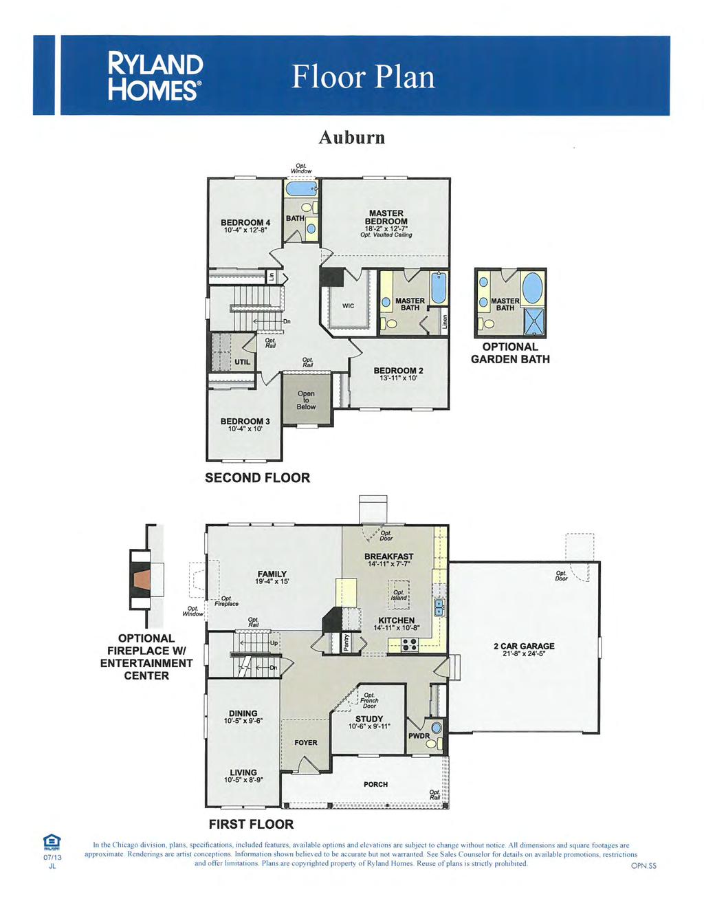
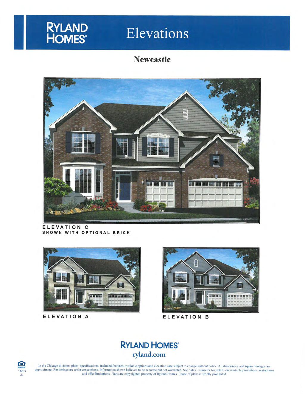
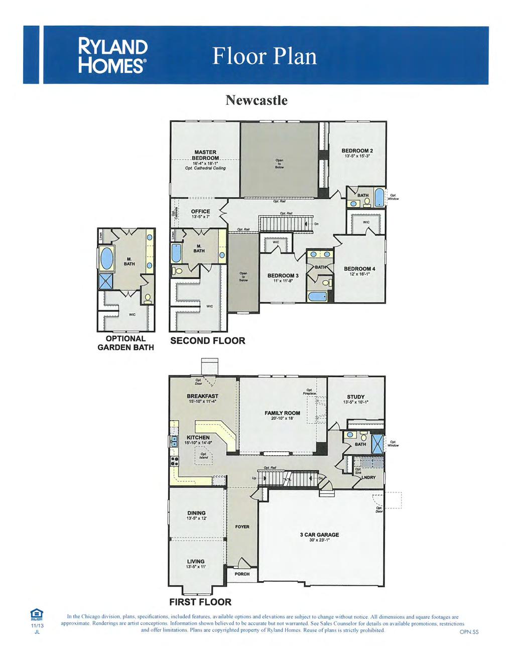
2 Planned Development Review Planning & Zoning Commission Pet March 2, 2015 BACKGROUND Ryland Homes has requested an amendment to the annexation agreement and an amendment to the planned district ordinances G47-06 and G48-06 and final plat approval for the Cedar Grove Subdivision, which is located at 901 & 1000 Corron Road. Ryland Homes proposes to convert 46 townhome units on 8 lots into 25 single-family residential lots, following the same architectural standards that exist today. Cedar Grove Subdivision is part of the larger Stonebrook Subdivision annexed to the City of Elgin in The approximately 317-acre parcel included 352 single family homes, 87 townhome units, and 94 acres of parks and open space. Minimum lot sizes within the single-family neighborhoods ranged from 10,000 to slightly over 21,000 square feet. In 2007, Ryland Homes received Final Plat approval for the approximately 53-acre Cedar Grove Subdivision, located south of Bowes Road and between Corron and Nesler Roads. This subdivision included 139 dwelling units single-family lots ranging in size from 10,125 to 21,295 square feet, and 87 townhome units contained within 15 buildings. Currently, 46 single-family homes and 17 townhome units have been constructed at Cedar Grove. Ryland Homes was forced to shut down their sales operations late in 2010 due to the slow economic recovery that took place after the Great Recession. Ryland Homes worked with staff and successfully reopened the single-family portion of the community in February 2013, and they have sold 35 homes since reopening. Ryland now proposes to modify the townhome portion of the development which will decrease the total dwelling unit count by 21. The applicant seeks approval to convert a portion of the approved townhome section, located west of Alberta Road and south of Pompton Avenue, from 46 townhomes on 8 lots to 25 single-family residential lots. The new single-family lots will range in size from 8,400 square feet to slightly over 13,000 square feet. The proposed addition of the 25 single-family lots will consist of 2 components single-family lots along Pompton Avenue, Connfier Drive, and Alberta Road and 4 lots located in the northeast corner of the property, north of Pompton Road and east of Nesler Road (see applicant s concept drawings within this packet for location). The northeast section will be developed by adding a u- shaped road with a landscaped island and incorporating the 4 single-family lots. The proposed single-family product would be identical to that offered in the existing portion of the development and consists of seven floorplans ranging in size from 2,420 to 3,800 square feet: the Auburn, Huntington, Windsor, Manchester, Normandy, Oxford and Newcastle. Each home has 4 bedrooms, 2.5 to 4 bathrooms, 2- to 3-car garages, and includes standard basements. The applicant proposes building a model home and opening a sales office within the community following approval of this modification to the plan. FINDINGS ON THE STANDARDS FOR PLANNED DEVELOPMENTS For consideration by the Planning & Zoning Commission the Community Development Department offers the following findings regarding this application. 2
3 Planned Development Review Planning & Zoning Commission Pet March 2, 2015 A. Site Characteristics Standard. The suitability of the subject property for the proposed planned development, with respect to its size, shape and any existing improvements. Findings: The subject property is suitable for the amendment to the zoning district with respect to the characteristics standard. The subject property under consideration is an irregularly shaped parcel containing approximately 7 acres of land. The property is currently vacant and was slated for townhome product when zoning and annexation was approved in B. Sewer and Water Standard. The suitability of the subject property for the proposed planned development with respect to the availability of adequate water, sanitary treatment, and stormwater control facilities. Findings: The subject property is suitable for the amendment to the zoning district with respect to the sewer and water standard. The subject property is served with municipal sanitary sewer and water services. Stormwater detention volume has been provided for on site and is in full compliance with the standards and regulations of the City of Elgin and Kane County Stormwater Management Ordinances. C. Traffic and Parking Standard. The suitability of the subject property for the proposed planned development with respect to the provision of safe and efficient on site and off site vehicular circulation designed to minimize traffic congestion. Findings: The subject property is suitable for the amendment to the zoning district with respect to the traffic and parking standard. The subject property has frontage along Pomton Avenue and Alberta Road. Both function as local streets providing access to other portions of the subdivision. Parking will be provided in conformance with the Off-Street Parking Ordinance. D. Zoning History Standard. The suitability of the subject property for the proposed planned development with respect to the length of time the property has remained undeveloped or unused in its current zoning district. Findings: The subject property is suitable for the amendment to the zoning district with respect to the length of time the property has remained undeveloped or unused in its current zoning district. The subject property was annexed in 2005 and zoned PSFR2 Planned Single Family Residence District; PMFR Planned Multiple Family Residence District and PCF Planned Community Facility District. E. Surrounding Land Use and Zoning Standard. The suitability of the subject property for the proposed planned development with respect to consistency and compatibility with surrounding land use and zoning. Findings: The subject property is suitable for the amendment to the zoning district with respect to consistency and compatibility with surrounding land use and zoning. The area to 3
4 Planned Development Review Planning & Zoning Commission Pet March 2, 2015 the west of the subject property is zoned PSFR2 Planned Single Family Residence District and PCF Planned Community Facility District and is improved with numerous single family homes and open space. The area to the north of the subject property is zoned F-District Farming in Kane County, and is currently being farmed. The area to the south of the subject property includes the following Kane County Subdivisions; Krog Acres, Westwinds Subdivision and Sturbridge Subdivision. The area to the east of the subject property is Burke Storage which is not within the city limits but falls within Kane County jurisdiction. F. Trend of Development Standard. The suitability of the subject property for the proposed planned development with respect to its consistency with an existing pattern of development or an identifiable trend of development in the area. Findings: The subject property is suitable for the amendment to the zoning district with respect to consistency with and existing pattern of development or an identifiable trend within the area. The subject property is located on the western fringe of the city limits. This area includes several City of Elgin subdivisions as well as Kane County estate residential developments and farmland. G. Zoning Districts Standard. The suitability of the subject property for the proposed planned development with respect to conformance to the provisions for the purpose and intent, and the location and size of a zoning district. The applicant is requesting an amendment to the PSFR2 Planned Single Family Residence District, PMFR Planned Multiple Family Residence District, and PCF Planned Community Facility District zoning. The purpose and intent of the provisions for planned developments is to accommodate unique development situations. For planned development districts, the planned development should demonstrate the following characteristics: 1. An opportunity to realize a development of demonstrated need with respect to the types of environment available to the public that would not be possible under the strict application of the other chapters of the zoning ordinance. 2. A creative approach to the use of land and related improvements resulting in better design and construction of aesthetic amenities. 3. The preservation of significant natural features including topography, watercourses, wetlands, and vegetation. Planned residential districts should be located in substantial conformance to the official comprehensive plan. The amount of land necessary to constitute a separate planned residential district exclusive of rights of way, but including adjoining land or land directly opposite a right of way shall not be less than two acres. No departure from the requested minimum size of a planned residential district shall be granted by City Council. 4
5 Planned Development Review Planning & Zoning Commission Pet March 2, 2015 Findings: The subject property is suitable for the proposed planned development with respect to conformance to the provisions for the purpose and intent, and the location and size of a planned residential district. The proposed modification of the site plan requires planned development approval through an amendment of the PSFR2 ordinance G48-06 and PMFR ordinance G H. Comprehensive Plan Standard. The suitability of the subject property for the proposed planned development with respect to conformance to the goals, objectives, and policies of the official comprehensive plan. Findings: The subject property is suitable for the intended zoning district with respect to the Comprehensive Plan Standard. A majority of the subject property area is designated Low Density Residential, in the city s Comprehensive Plan and Design Guidelines dates Areas designated Low Density Residential provides for the development of conventional single family detached houses. Appropriate locations offer neighborhood access to collector roads, access to water and sanitary sewer systems, and proximity to public safety services. The provision of park and open space is encouraged to provide opportunities for recreational and access to pedestrian and bicycle trail systems. Other uses allowed in this category may include neighborhood commercial centers, churches and schools in locations deemed appropriated by the city. The proposed housing will comply with all applicable standards and guidelines promoting quality construction and design for what will be move-up and executive housing. I. Natural Preservation Standard. The suitability of the subject property for the proposed planned development with respect to the preservation of all significant natural features including topography, watercourses, wetlands, and vegetation. Findings: The subject property is suitable for the amendment to the zoning district with respect to the natural preservation standard. There are no significant natural features located in or around the portion of the subdivision that would be changed. The site has been mass graded for construction and has a majority of the city streets and underground infrastructure already in place. J. Internal Land Use Standard. The suitability of the subject property for the intended planned development with respect to the land uses permitted within the development being located, designed, and operated so as to exercise no undue detrimental influence on each other or on surrounding property. Findings: The subject property is suitable for the amendment to the zoning district with respect to the internal land use standard. Based on the information reviewed thus far, no evidence has been found that the requested planned development will be located, designed, and operated in a manner that will exercise undue detrimental influence on itself or surrounding property. 5
6 Planned Development Review Planning & Zoning Commission Pet March 2, 2015 PLANNED DEVELOPMENT DEPARTURES AND EXCEPTIONS A planned development may be granted certain departures from the normal standards, regulations, requirements, and procedures of the Elgin Zoning Ordinance and Subdivision Ordinance. Stonebrook Subdivision was approved in 2005, with a number of departures from the standard requirements of the zoning and subdivision regulations. The applicant is requesting the following departure from the requirements of Ordinance G48-06 entitled An Ordinance Classifying Newly Annexed Territory in the PSFR2 Planned Single Family Residence District (Stonebrook Subdivision 901 and 1000 Corron Road) (Tract 14) Section (B) Lot Area. In the SFR2 District, the minimum required zoning lot area is 10,000 square feet per dwelling unit. The applicant requests a minimum 8,400 square foot zoning lot area for 16 of the 25 proposed single family lots. Of these 16 lots it is worth noting that 6 of the lots directly back up to common open space thus creating the look and feel of a much larger lot. Section (C) Lot Width. In the SFR2 District, the minimum required lot width for a zoning lot is 75 feet. The applicant requests a minimum 70 foot lot width for 7 of the 25 proposed single family lots. Those lots are located primarily south of Pompton Avenue. Section (E.1.C.) Street Setback. In the SFR2 District, the minimum building setback from a local street lot line is 30 feet. In the 2006 planned development approval, the applicant was granted a minimum building setback of 25 feet from the local street right of way. The applicant is now requesting a minimum building setback of 23.5 feet from the local street right of way for 8 of the 25 proposed single family lots. A majority of those lots are south of Connifer Drive which back up to the common open space located along the south property line of the subject property. Section (E.3.) Interior Setback. In the SFR2 District, the minimum required building setback from an interior lot line is 10 feet. In the 2006 planned development approval the applicant was granted a minimum interior building setback of 7 feet for the minimum 10,000 and 11,250 square foot lots, and 8 feet for the minimum 13,250 square foot lots. The applicant is now requesting a minimum interior building setback of 5 feet for 19 of the 25 proposed single family lots. Section (E.4.) Rear Setback. In the SFR2 District, the minimum required building setback from a rear lot line is 40 feet. In the 2006 planned development approval the applicant was granted a minimum 30-foot building setback from a rear lot line for the minimum 10,000 and 11,250 square foot lots and 35 feet for the minimum 13,250 square foot lots. The applicant is now requesting a minimum 15-foot building setback from a rear lot line for the 25 proposed single family lots. Section (E.5.) Transition Setback. In the SFR2 District, the minimum building setback from an adjoining CF district is 50 feet. In the 2006 planned development approval, the applicant was granted that the minimum transition building setback match the interior or 6
7 Planned Development Review Planning & Zoning Commission Pet March 2, 2015 rear setbacks, which have been identified above, whichever is applicable. The applicant is making the same request from 2006 in that the transition setback match the proposed interior or rear setbacks, which have been identified above, whichever is applicable. COMMENTS FROM OTHER CITY DEPARTMENTS The following are additional comments and/or requirements provided by other city departments regarding the applicability of life/safety and other codes and whether or not that applicability materially affects the project plans. 1. Fire Department Comments that materially affect the site and/or building plans No comments Comments that will be addressed during the Plan Review/Permitting process No Comments 2. Community Development Building and Development Division Comments that materially affect the site and/or building plans No Comments Comments that will be addressed during the Plan Review/Permitting process No Comments 3. Community Development Code Enforcement Division Comments that materially affect the site and/or building plans No Comments Comments that will be addressed during the Plan Review/Permitting process Not Applicable 4. Public Works - Engineering Division Comments that materially affect the site and/or building plans No Comments Comments that will be addressed during the Plan Review/Permitting process No Comments 5. Police Department Comments that materially affect the site and/or building plans No Issues Comments that will be addressed during the Plan Review/Permitting process No Issues 7
8 Planned Development Review Planning & Zoning Commission Pet March 2, Public Works Parks and Open Space Maintenance Comments that materially affect the site and/or building plans No comments Comments that will be addressed during the Plan Review/Permitting process Not Applicable 7. Water Department Comments that materially affect the site and/or building plans No Comments Comments that will be addressed during the Plan Review/Permitting process No Comments RECOMMENDATION The Community Development Group recommends approval of Petition subject to the following conditions: 1. Substantial conformance with the Petitioner s Statement of Purpose and attachments, dated received November 20, Substantial conformance to the Consent and Disclosure, dated received November 20, Substantial conformance to the Zoning Exhibit, Sheet 1 of 1, prepared by Mackie Consultants, LLC, dated November 14, 2014 and dated received November 20, Substantial conformance to the Concept Site Plan East Development for Cedar Grove, Sheet 1 of 1, prepared by Mackie Consultants, LLC, dated revised November 12, 2014 and dated received November 20, Substantial conformance to the Landscape Plan, Sheet 1 of 1, prepared by Gary R. Weber Associates, Inc., dated November 17, 2014 and dated received November 20, Substantial conformance to the following building elevations and floor plan project sheets, The Auburn, The Huntington, The Windsor, The Manchester, The Normandy, The Oxford, and The Newcastle. 7. Substantial conformance to the Final Plat of Subdivision and PUD Plan, Resubdivision of Cedar Grove, prepared by Mackie Consultants, LLC, dated February 19, 2015 subject to the revisions required by the Community Development, Engineering, Water, Fire and Legal Departments. 8. Compliance with all applicable codes and ordinances. 8
9 Planned Development Review Planning & Zoning Commission Pet March 2, 2015 Respectfully Submitted, Dave Waden Senior Planner 9
10 Oak Tree Ln Nesler Rd Subject Property Petition Corron Rd Conifer Ct Canfield Cir Bowes Rd Lori Ln Pompton Ave Pompton Ct Conifer Dr Alberta Rd Valhalla Dr Kingsmill Dr EXHIBIT A Map prepared by City of Elgin Department of Community Development Aerial/Location Map Feet
11 Bowes Rd Nesler Rd Subject Property Petition Conifer Ct Lori Ln Canfield Cir Bowes Legend PCF Oak Tree Ln PSFR2 Residence Conservation 1 Residence Conservation 2 Residence Conservation 3 Planned Residence Conservation Single Family Residence 1 Single Family Residence 2 Planned Single Family Residence 2 Two Family Residence Multiple Family Residence Planned Multiple Family Residence Residence Business Planned Residential Business Neighborhood Business Planned Neighborhood Business Area Business Planned Area Business Center City 1 Center City 2 Planned Center City Office Research Industrial Planned Office Research Industrial General Industrial Planned General Industrial Commercial Industrial Planned Community Facility Community Facility Fox River Preservation Planned Center City 2 Planned Single Family Residence 1 Planned Two Family Residence EXHIBIT B Conifer Dr Pompton Ave Alberta Rd Pompton Ct PMFR Zoning Map Pompton PCF PSFR2 PCF PSFR2. Map prepared by City of Elgin Department of Community Development Feet
12 Subject Property Petition Bowes Rd Alberta Rd Pompton Ct Pompton Ave Nesler Rd Conifer Dr EXHBIIT C City of Elgin Department of Community Development Parcel Map Feet
13 SITE LOCATION EXHIBIT 901 & 1000 Corron Road (Cedar Grove Subdivision) Petition Overall Site Location East Portion of Cedar Grove
14 SITE LOCATION EXHIBIT 901 & 1000 Corron Road (Cedar Grove Subdivision) Petition View from Pompton Ave. Looking East View from near the end of Pompton Ave. Looking West Site Pictures 1
15 SITE LOCATION EXHIBIT 901 & 1000 Corron Road (Cedar Grove Subdivision) Petition View from Pompton Ave. Looking Southwest View from Alberta Road Looking Northeast Site Pictures 2
16 CEDAR GROVE SUBDIVISION APPLICATION STATEMENT OF PURPOSE AND ATTACHMENTS PETITION 57-14
17
18
19
20
21
22

23

24 PCF PMFR PSFR-2 PSFR-2 PCF
25
26
27
28
29

30
31
32
33
34
35
36
37

38
39

40
41
42
43
44
45 CEDAR GROVE SUBDIVISION DRAFT PMFR ORDINANCE PETITION 57-14
46 Draft Ordinance No. Gxx-15 AN ORDINANCE AMENDING PMFR PLANNED MULTIPLE FAMILY RESIDENCE DISTRICT ORDINANCE G47-06 (Stonebrook Subdivision 901 and 1000 Corron Road) (Tract 15) WHEREAS, the territory herein described has been annexed to the City of Elgin; and WHEREAS, written application has been made to classify said territory to a PMFR Planned Multiple Family Residence District; and WHEREAS, after due notice in the manner provided by law the Planning & Zoning Commission conducted a public hearing concerning said application and has submitted its written findings and recommendations; and WHEREAS, the City Council of the City of Elgin, Illinois, has reviewed the findings and recommendations of the Planning and Development Commission. NOW, THEREFORE, BE IT ORDAINED BY THE CITY COUNCIL OF THE CITY OF ELGIN, ILLINOIS: Section 1. That Chapter 19.07, Section entitled Zoning District Map of the Elgin Municipal Code, 1976, as amended, be and the same is hereby further amended by adding thereto the following paragraph: PARCEL1: The boundaries herein before laid out in the Zoning District Map, as amended, be and are hereby altered by including in the PMFR Planned Multiple Family Residence District, the following described property: THAT PART OF LOTS 58, 67, 68, 69, 70, 71, 72, 73, AND 74 IN CEDAR GROVE SUBDIVISION, BEING A SUBDIVISION OF PART OF THE NORTH HALF OF SECTIONS 25 AND 26, TOWNSHIP 41 NORTH, RANGE 7, EAST OF THE THIRD PRINCIPAL MERIDIAN, ACCORDING TO THE PLAT THEREOF RECORDED ON FEBRUARY 29, 2008 AS DOCUMENT NUMBER 2008K017136, MORE PARTICULARLY DESCRIBED AS FOLLOWS: BEGINNING AT THE NORTHERLY MOST CORNER OF LOT 58; THENCE SOUTH 70 DEGREES 54 MINUTES 38 SECONDS EAST, A DISTANCE OF FEET, ALONG THE NORTHERLY LINE OF SAID LOT 58 AND ALSO BEING THE SOUTH LINE OF POMPTON AVENUE; THENCE SOUTH 19 DEGREES 05 MINUTES 22 SECONDS WEST, A DISTANCE OF FEET; THENCE ALONG A CURVE CONCAVE NORTHWESTERLY, HAVING A RADIUS OF FEET, AN ARC DISTANCE FEET, AND A CHORD BEARING SOUTH 47 DEGREES 45 MINUTES 17 SECONDS WEST; THENCE SOUTH 76 DEGREES 25 MINUTES 12 SECONDS WEST, A DISTANCE OF FEET; THENCE SOUTH 01 DEGREE 26 MINUTES 37 SECONDS EAST, A DISTANCE OF FEET; THENCE SOUTH 88 DEGREES 33 MINUTES 23 SECONDS WEST, A DISTANCE OF FEET, TO A
47 WESTERLY LINE OF SAID LOT 58, AND ALSO BEING AN EASTERLY LINE OF LOT 38 IN SAID CEDAR GROVE SUBDIVISION; THENCE NORTH 01 DEGREE 26 MINUTES 37 SECONDS WEST, A DISTANCE OF FEET, ALONG SAID WESTERLY LINE OF LOT 58; THENCE NORTH 04 DEGREES 52 MINUTES 22 SECONDS EAST, A DISTANCE OF FEET, ALONG A WESTERLY LINE OF SAID LOT 58 AND ALSO BEING AN EASTERLY LINE OF LOT 37 IN SAID CEDAR GROVE SUBDIVISION; THENCE NORTH 70 DEGREES 54 MINUTES 38 SECONDS WEST, A DISTANCE OF FEET, ALONG A BOUNDARY LINE OF SAID LOT 58 AND ALSO BEING A NORTHERLY LINE OF LOT 37 IN SAID CEDAR GROVE SUBDIVISION; THENCE NORTH 19 DEGREES 05 MINUTES 22 SECONDS EAST, A DISTANCE OF FEET, ALONG A WESTERLY LINE OF SAID LOT 58 AND ALSO BEING AN EASTERLY LINE OF ALBERTA ROAD; THENCE SOUTH 70 DEGREES 54 MINUTES 38 SECONDS EAST, A DISTANCE OF FEET, ALONG A BOUNDARY LINE OF SAID LOT 58 AND ALSO BEING A SOUTHERLY LINE OF LOT 36 IN SAID CEDAR GROVE SUBDIVISION; THENCE NORTH 19 DEGREES 05 MINUTES 22 SECONDS EAST, A DISTANCE OF FEET, ALONG A WESTERLY LINE OF SAID LOT 58 AND ALSO BEING AN EASTERLY LINE OF LOTS 36, 35 AND 34 IN SAID CEDAR GROVE SUBDIVISION, TO THE POINT OF BEGINNING, ALL IN KANE COUNTY, ILLINOIS. PARCEL 2: LOT 57 IN CEDAR GROVE SUBDIVISION, BEING A SUBDIVISION OF PART OF THE NORTH HALF OF SECTIONS 25 AND 26, TOWNSHIP 41 NORTH, RANGE 7, EAST OF THE THIRD PRINCIPAL MERIDIAN, ACCORDING TO THE PLAT THEREOF RECORDED FEBRUARY 29, 2008 AS DOCUMENT NUMBER 2008K017136, IN KANE COUNTY, ILLINOIS. And subject to the following conditions: 1. Substantial conformance with the Petitioner s Application, Statement of Purpose, Consent and Disclosure, and attachments dated November 20, Substantial conformance to the Consent and Disclosure, dated received November 20, Substantial conformance to the Zoning Exhibit, Sheet 1 of 1, prepared by Mackie Consultants, LLC, dated November 14, 2014 and dated received November 20, Substantial conformance to the Concept Site Plan East Development for Cedar Grove, Sheet 1 of 1, prepared by Mackie Consultants, LLC, dated revised November 12, 2014 and dated received November 20, Substantial conformance to the Landscape Plan, Sheet 1 of 1, prepared by Gary R. Weber Associates, Inc., dated November 17, 2014 and dated received November 20,
48 6. Substantial conformance to the following building elevations and floor plan project sheets, The Auburn, The Huntington, The Windsor, The Manchester, The Normandy, The Oxford, and The Newcastle. 7.Substantial conformance to the Final Plat of Subdivision and PUD Plan, Resubdivision of Cedar Grove, prepared by Mackie Consultants, LLC, dated February 19, 2015 subject to the revisions required by the Community Development, Engineering, Water, Fire and Legal Departments. Section 3. That except as amended herein, the use and development of the Subject Property shall be controlled pursuant to the provisions of Ordinance No. G In the event of any conflict between this ordinance, which expressly includes those documents detailed within Section 2 and the allowances and departures described and provided thereon, and Ordinance No G47-06, this ordinance and associated documents shall control and prevail. Section 4. That this ordinance shall be full force and effect immediately after its passage in the manner provided by law. s/ David J. Kaptain, Mayor Presented: Passed: Omnibus Vote: Yeas: Nays: Recorded: Published: Attest: s/ Kimberly A. Dewis, City Clerk - 3 -
49 CEDAR GROVE SUBDIVISION DRAFT PSFR2 ORDINANCE PETITION 57-14
50 Draft Ordinance No. Gxx-15 AN ORDINANCE AMENDING PSFR2 PLANNED SINGLE FAMILY RESIDENCE DISTRICT ORDINANCE NO. G48-06 (Stonebrook Subdivision 901 and 1000 Corron Road) (Tract 14) WHEREAS, the territory herein described has been annexed to the City of Elgin and originally classified in the PSFR2 Planned Single Family Residence District under Ordinance No. G48-06; and WHEREAS, written application has been made to amend PSFR2 Planned Single Family Residence District Ordinance No. G48-06 to modify the multiple family portion of the development from 46 townhomes to 25 single family lots and net decrease of 21 total units. within the Cedar Grove Subdivision; and WHEREAS, after due notice in the manner provided by law the Planning & Zoning Commission conducted public hearings concerning said applications and has submitted its written findings and recommendations; and WHEREAS, the City Council of the City of Elgin, Illinois, has reviewed the findings and recommendations of the Planning & Zoning Commission. NOW, THEREFORE, BE IT ORDAINED BY THE CITY COUNCIL OF THE CITY OF ELGIN, ILLINOIS: Section 1. That the City Council of the City of Elgin hereby adopts the Findings of Fact, dated March , made by the Planning & Zoning Commission, a copy of which is attached hereto and made a part hereof by reference as Exhibit A. Section 2. That Ordinance No. G48-06 entitled An Ordinance Classifying Newly Annexed Territory in the PSFR2 Planned Single Family Residence District (Stonebrook Subdivision 901 and 1000 Corron Road) (Tract 14), passed June 14, 2006, be and is hereby amended only as set forth in this ordinance by amending Section G.2 through 4, entitled Site Design Lot Area, Lot Width, Setbacks Generally, Setbacks by Lot Line in their entirety as follows: 2. Zoning Area. The minimum required lot area shall be 8,400 square feet. 3. Lot Width. The minimum required lot width for a zoning lot shall be 70 feet. 4. Street Setback. The minimum required building setback shall be 23.5 from the local street right of way.
51 5. Interior Setback. The minimum required interior building setback shall be 5 feet. 6. Rear Setback. The minimum required setback from a rear lot line shall be 15 feet. 7. Transition Setback. The minimum transition setback shall match the proposed interior (5 feet) or rear (15 feet) setbacks. And subject to the following conditions: 1. Substantial conformance with the Petitioner s Application, Statement of Purpose, Consent and Disclosure, and attachments dated November 20, Substantial conformance to the Zoning Exhibit, Sheet 1 of, prepared by Mackie Consultants, LLC, dated November 14, 2014 and dated received November 20, Substantial conformance to the Concept Site Plan East Development for Cedar Grove Sheet 1 of 1, prepared by Mackie Consultants, LLC, dated revised November 12, 2014 and dated received November 20, Substantial conformance to the following building elevations and floor plan project sheets The Auburn, The Huntington, The Windsor, The Manchester, The Normandy, The Oxford, and The Newcastle. 5. Substantial conformance to the Final Plat of Subdivision and PUD Plan Resubdivision of Cedar Grove, prepared by Mackie Consultants, LLC, dated February 19, 2015 subject to the revisions required by the Community Development, Engineering, Water, Fire and Legal Departments. 6. Compliance with all applicable codes and ordinances. Section 3. That except as amended herein, the use and development of the Subject Property shall be controlled pursuant to the provisions of Ordinance No. G In the event of any conflict between this ordinance, which expressly includes those documents detailed within Section 2 and the allowances and departures described and provided thereon, and Ordinance No G48-06, this ordinance and associated documents shall control and prevail. Section 4. That this ordinance shall be full force and effect immediately after its passage in the manner provided by law. David J. Kaptain, Mayor - 2 -
52 Presented: Passed: Vote: Yeas Recorded: Published: Nays: Attest: Kimberly A. Dewis, City Clerk - 3 -
53 DEVELOPMENT REVIEW SCHEDULE The Community Development Department City of Elgin Week of March 2, 2015 City Council Meeting of March 18, 2015 (tentative) Pet. # Project/Applicant Name Project Address Type of Application Description of Request Awaiting... Staff Symphony Way 166 Symphony Way Conditional Use Allow for new assembly uses on property Ordinance Approval by City Council DM City of Elgin City Wide Text Amendments Various amendments to Title 19 ZONING of the Elgin Municipal Code Ordinance Approval by City Council MM Planning & Zoning Commission Meeting of March 2, 2015 Pet. # Project/Applicant Name Project Address Type of Application Description of Request Awaiting... Staff Versa Development / Starbucks 815 S Randall Rd Ryland Homes Cedar Grove Subdivision Planned Development as a Map Amendment Planned Development as a Map Amendment Amend PAB Ord. G46 06 to subdivide and establish a drive thru facility, and Final Plat approval Amend Annexation Agreement, Amend PSRF2 Ord. G47 06 and PMFR Ord. G48 06, and Final Plat approval RAM Foods 725 W Chicago St Conditional Use Establish accessory package liquor sales Consideration by P&Z Commission Consideration by P&Z Commission Consideration by P&Z Commission DM MM MM Pending City Council Items Pet. # Project/Applicant Name Project Address Type of Application Description of Request Awaiting... Staff The Residences of Pingree Creek Shodeen 1551 Reinking Rd Final Plat of Subdivision Subdivide approximately 86 acres for multi family residential development Applicant's revisions DW Randall Crossings Business Park 2760 Alft Ln & 2770 Alft Ct Final Plat of Subdivision Resubdivision of lots 2 and 3 Applicant's submission of signed plat and approval of Final Engineering SS & Plote Homes LLC 980 Lambert Ln Rezoning (Planned Development) & Stormwater Variation Establish industrial condo and outside storage on vacant property (from GI to PGI); and requesting a departure of the stormwater level fluctuation Ordinance consideration DM Page 1 of 2
54 New or Pending Planning & Zoning Commission Items Pet. # Project/Applicant Name Project Address Type of Application Description of Request Awaiting... Staff Bluff City Materials / Gifford Gifford Stonebrook Subdivision Units 1 & and 1000 Corron Road Planned Development Ordinance Amendment Annexation Agreement and Planned Development Ordinance Amendment Moose Lodge / Verizon Wireless 925 S McLean Blvd Conditional Use Modify the Preliminary Plat Modify product to include street facing garage forward elevations, and other misc. changes Request to install a cellular tower; not meeting fall zone setback requirements Applicant's response to staff comments Completion of Subdivision items Staff review DW SS DM Summit School / Verizon Wireless 333 W River Rd Conditional Use Ambrose Design Group LLC SW Corner of Nesler Rd and Route 20 Annexation Agreement and Preliminary Plat Request to install a cellular tower; not meeting fall zone setback requirements Annexation of vacant land to establish a motor vehicle service station/convenience store, with a drive thru restaurant Applicant's response to staff comments Staff review Store Capital 155 S Randall Rd Zoning Verification Verify zoning entitlements on property Response letter in progress Abbreviations are as follows: CC: City Council Cindy Walden CW: P&Z: Planning & Zoning Commission Dave Waden DW: Denise Momodu DM: Marc Mylott MM Sarosh Saher SS: reviewing staff member to be determined tbd: DM tbd DW Page 2 of 2
PLANNING & ZONING COMMISSION Monday, April 6, :00 pm
 PLANNING & ZONING COMMISSION Monday, April 6, 2015 7:00 pm City of Elgin City Council Chambers - 2 nd Floor North Tower 150 Dexter Court, Elgin, IL 60120 AGENDA A. Call Meeting to Order and Roll Call B.
PLANNING & ZONING COMMISSION Monday, June 4, :00 pm
 PLANNING & ZONING COMMISSION Monday, June 4, 2017 7:00 pm City of Elgin City Council Chambers - 2 nd Floor North Tower 150 Dexter Court, Elgin, IL 60120 AGENDA A. Call Meeting to Order B. Roll Call C.
PLANNING & ZONING COMMISSION Monday, April 3, :00 pm
 PLANNING & ZONING COMMISSION Monday, April 3, 2017 7:00 pm City of Elgin City Council Chambers - 2 nd Floor North Tower 150 Dexter Court, Elgin, IL 60120 AGENDA A. Call Meeting to Order B. Roll Call C.
Town of Cary, North Carolina Rezoning Staff Report 14-REZ-31 Cary Park PDD Amendment (Waterford II) Town Council Meeting January 15, 2015
 Town Council Meeting January 15, 2015") Town of Cary, North Carolina Rezoning Staff Report 14-REZ-31 Cary Park PDD Amendment (Waterford II) Town Council Meeting January 15, 2015 REQUEST To amend the Town of Cary Official Zoning Map by amending
Town of Cary, North Carolina Rezoning Staff Report 14-REZ-31 Cary Park PDD Amendment (Waterford II) Town Council Meeting January 15, 2015 REQUEST To amend the Town of Cary Official Zoning Map by amending
ORDINANCE NO (As Amended)
") ORDINANCE NO. 01-2015 (As Amended) To Amend the Official Zoning Map of the City of Worthington, Ohio, to Change Zoning of Certain Land from the C-3 District (Institutions and Office), AR-4.5 District (Low
ORDINANCE NO. 01-2015 (As Amended) To Amend the Official Zoning Map of the City of Worthington, Ohio, to Change Zoning of Certain Land from the C-3 District (Institutions and Office), AR-4.5 District (Low
VILLAGE OF ORLAND PARK
 14700 Ravinia Avenue Orland Park, IL 60462 www.orlandpark.org Ordinance No: File Number: 2016-0865 ORDINANCE REZONING CERTAIN REAL ESTATE FROM E-1 ESTATE RESIDENTIAL DISTRICT TO COR MIXED USE DISTRICT
Planning and Zoning Commission Development Application Review April 1, 2019
 The Planning and Zoning Planning and Zoning Commission Development Application Review April, 209 COMMUNITY GARDENS CITY OF ELGIN CHANNING SQUARE Amendment to Planned Development The City Council files
TOWNSHIP OF ALGOMA. County, Michigan, held in the Algoma Township Hall, Algoma Avenue, N.E., within
 TOWNSHIP OF ALGOMA COUNTY OF KENT, MICHIGAN At a special meeting of the Township Board of the Township of Algoma, Kent County, Michigan, held in the Algoma Township Hall, 10531 Algoma Avenue, N.E., within
Stenberg Annexation Legal Diagram Exhibit "B" W Subject Property Annexed to the City of Red Bluff VICINITY MAP "1:3:
 Stenberg Annexation Legal Diagram Exhibit "B" W Subject Property Annexed to the City of Red Bluff VICINITY MAP "1:3: ORDINANCE NO. 991 REZONE NO. 210 AN ORDINANCE AMENDING SECTION 25.13 OF THE RED BLUFF
PUD Ordinance - Cascade Lakes Plat #10 of 1995
 PUD Ordinance - Cascade Lakes Plat #10 of 1995 CASCADE CHARTER TOWNSHIP Ordinance #10 of 1995 AN ORDINANCE TO AMEND THE CASCADE CHARTER TOWNSHIP ZONING ORDINANCE AND ZONING MAP TO ESTABLISH THE CASCADE
City Council Information Form
 City Council Information Form DATE: 08/13/2014 ASSIGNED STAFF: Robert McKay DEPARTMENT: Planning&Development TYPE OF FORM: Ordinances Form No.: 4490 APPROVALS: None ISSUE/REQUEST: AN ORDINANCE VACATING
DU PAGE COUNTY ZONING BOARD OF APPEALS JACK T. KNUEPFER ADMINISTRATION BUILDING 421 NORTH COUNTY FARM ROAD, WHEATON, ILLINOIS 60187/
 DU PAGE COUNTY ZONING BOARD OF APPEALS JACK T. KNUEPFER ADMINISTRATION BUILDING 421 NORTH COUNTY FARM ROAD, WHEATON, ILLINOIS 60187/ 630-407-6700 M E M O R A N D U M TO: FROM: DuPage County Board DuPage
ORDINANCE NO. Z REZONING NO
 ORDINANCE NO. Z- 3960 REZONING NO. 2018-00014 AN ORDINANCE RELATING TO ZONING: AMENDING CERTAIN ZONING REGULATIONS SHOWN ON SHEET NO. 15 OF THE ZONING DISTRICT MAP INCORPORATED BY REFERENCE BY OVERLAND
ACTION FORM BRYAN CITY COUNCIL
 ACTION FORM BRYAN CITY COUNCIL DATE OF COUNCIL MEETING: July 8, 2014 DATE SUBMITTED: June 17, 2014 DEPARTMENT OF ORIGIN: Development Services SUBMITTED BY: Maggie Dalton MEETING TYPE: CLASSIFICATION: ORDINANCE:
GeoPoint 213 Hobbs Street Tampa, Florida
 AIRPORT ROAD PINELAND P.R.D. SUBDIVISION - PHASES 2 & 3 DESCRIPTION: A parcel of land lying in Sections 13 and 24, Township 14 South, Range 31 East, Volusia County, Florida, and being more particularly
ORDINANCE NO. NOW, THEREFORE, BE IT ORDAINED BY THE COUNTY BOARD OF OGLE COUNTY, ILLINOIS, as follows:
 STATE OF ILLINOIS ) ) SS COUNTY OF OGLE ) ORDINANCE NO. AN ORDINANCE APPROVING A ZONING MAP AMENDMENT ON PROPERTY LOCATED AT THE SOUTHEAST CORNER OF THE INTERSECTION OF N. JUNCTION ROAD AND DIVISION STREET,
ARTICLE 15 - PLANNED UNIT DEVELOPMENT
 Section 15.1 - Intent. ARTICLE 15 - PLANNED UNIT DEVELOPMENT A PUD, or Planned Unit Development, is not a District per se, but rather a set of standards that may be applied to a development type. The Planned
FOURTH AMENDMENT TO ANNEXATION AGREEMENT
 FOURTH AMENDMENT TO ANNEXATION AGREEMENT This Fourth Amendment to the Annexation Agreement (the Third Amendment ), is made as of the day of, 2014, by and between Winchester Commercial Partners, LLC, an
CITY OF OCALA CITY COUNCIL REPORT Council Meeting Date: 06/06/17
 CITY OF OCALA CITY COUNCIL REPORT Council Meeting Date: 06/06/17 Subject: Large Scale Land Use Map Amendment Submitted By: David Boston Department: Growth Management STAFF RECOMMENDATION (Motion Ready):
PUD, HPUD, OSC Rezoning & Conceptual Plan Application (Planned Unit Development, Haggerty Road Planned Unit Development, Open Space Community)
") Township Use Only RZ #: Date: Hearing Date: Fee Paid: PUD, HPUD, OSC Rezoning & Conceptual Plan Application (Planned Unit Development, Haggerty Road Planned Unit Development, Open Space Community) Project
Township Use Only RZ #: Date: Hearing Date: Fee Paid: PUD, HPUD, OSC Rezoning & Conceptual Plan Application (Planned Unit Development, Haggerty Road Planned Unit Development, Open Space Community) Project
RESOLUTION NO CITY OF MAPLE GROVE
 RESOLUTION NO. 18-122 CITY OF MAPLE GROVE RESOLUTION GRANTING PLANNED UNIT DEVELOPMENT CONCEPT STAGE PLAN, PLANNED UNIT DEVELOPMENT - DEVELOPMENT STAGE PLAN, AND PRELIMINARY PLAT FOR TERRITORIAL GREENS
Stockton Manor Elevations
 Left Elevation Front Elevation Right Elevation Rear Elevation Stockton Manor Elevations 3834 Sq. Ft. 50'-0" x 53'-0" Stonebrook 02/03/2015 Left Elevation Front Elevation Right Elevation Rear Elevation
SUBJECT: Official Plan and Zoning By-law Amendment Applications for 4853 Thomas Alton Boulevard
 Page 1 of Report PB-100-16 SUBJECT: Official Plan and Zoning By-law Amendment Applications for 4853 Thomas Alton Boulevard TO: FROM: Development and Infrastructure Committee Planning and Building Department
I. Requirements for All Applications. C D W
 108-16.1. Application checklists. Checklist for Required Submissions to the Planning Board or Zoning Board of Adjustment of Monroe Township All required submissions are to be made to the Administrative
Background. November 15, 2017 Streamside at Heatherwoode PUD-R Rezoning Public Hearing Information Sheet Page 1 City of Springboro, Ohio
 Background and Rezoning Process Summary Proposed Streamside at Heatherwoode Residential Subdivision 1360 South Main Street (SR 741) Rezoning from R-1, Estate-Type Residential District, to PUD-R, Planned
42-Acre Parcel Rezoning and Master Plan Amendment. Danny Cagle and Patrick Stanley 6301 Duckweed Rd. Lake Worth, FL 33449
 STAFF REPORT CITY OF PARKLAND DEVELOPMENT SERVICES DEPARTMENT Date Prepared: May 2, 2014 I. Petition Description Petition No.: Project Name: Owners: RZ14-001; MPA14-002 42-Acre Parcel Rezoning and Master
PLANNED UNIT DEVELOPMENTS (Ordinance No.: 3036, 12/3/07; Repealed & Replaced by Ordinance No.: 4166, 10/15/12)
") 159.62 PLANNED UNIT DEVELOPMENTS (Ordinance No.: 3036, 12/3/07; Repealed & Replaced by Ordinance No.: 4166, 10/15/12) A. PURPOSE 1. General. The Planned Unit Development (PUD) approach provides the flexibility
159.62 PLANNED UNIT DEVELOPMENTS (Ordinance No.: 3036, 12/3/07; Repealed & Replaced by Ordinance No.: 4166, 10/15/12) A. PURPOSE 1. General. The Planned Unit Development (PUD) approach provides the flexibility
ORDINANCE NO. CID-3087
 ORDINANCE NO. CID-3087 AN ORDINANCE MAKING FINDINGS AS TO THE NATURE AND ADVISABILITY OF CREATING A COMMUNITY IMPROVEMENT DISTRICT AT THE NORTHEAST CORNER OF 91 ST STREET AND METCALF AVENUE; CREATING SAID
PLANNED DEVELOPMENT DISTRICT STANDARDS. Cadence Site
 PLANNED DEVELOPMENT DISTRICT STANDARDS Cadence Site A Planned Development District 1. Statement of General Facts, Conditions and Objectives Property Size: Approximately 57.51 Acres York County Tax Map
City of Grande Prairie Development Services Department
 City of Grande Prairie Development Services Department COUNTRYSIDE SOUTH OUTLINE PLAN Prepared by: GPEC Consulting Ltd. #202, 10712-100th Street Grande Prairie, AB Council Resolution of August 20, 2001
CHAPTER 14 PLANNED UNIT DEVELOPMENTS
 9-14-1 9-14-1 CHAPTER 14 PLANNED UNIT DEVELOPMENTS SECTION: 9-14-1: Purpose 9-14-2: Governing Provisions 9-14-3: Minimum Area 9-14-4: Uses Permitted 9-14-5: Common Open Space 9-14-6: Utility Requirements
Town of Cary, North Carolina Rezoning Staff Report 12-REZ-27 Morris Branch Town Council Public Hearing January 24, 2013
 Town of Cary, North Carolina Rezoning Staff Report 12-REZ-27 Morris Branch Town Council Public Hearing January 24, 2013 REQUEST To amend the Town of Cary Official Zoning Map to rezone approximately 9.0
CHAPTER XIX ANNEXATION ARTICLE 1. ANNEXATION
 CHAPTER XIX ANNEXATION ARTICLE 1. ANNEXATION 19.0101 JABORSKY ADDITION: WHEREAS, The City of Belfield pursuant to Section 40-51.2-07 of the North Dakota Century Code has amended having passed a Resolution
Marion County Board of County Commissioners
 Marion County Board of County Commissioners Date: 12/29/2015 P&Z: 12/28/2015 BCC: 1/12/2016 Item Number 160113Z Type of Application Rezoning Request From: A-1 (General Agriculture) To: PUD (Planned Unit
RESOLUTION NO. RD:EEH:LCP
 RESOLUTION NO. A RESOLUTION OF THE COUNCIL OF THE CITY OF SAN JOSE CONDITIONALLY VACATING A PORTION OF MERIDIAN AVENUE, SOUTH OF FRUITDALE AVENUE, AND RESERVING A PUBLIC SERVICE EASEMENT OVER THE VACATED
For Vintages of Four Mile Creek Town of Niagara on the Lake, Ontario
 Planning Impact Analysis For Vintages of Four Mile Creek Town of Niagara on the Lake, Ontario Prepared by: Upper Canada Consultants 261 Martindale Road Unit #1 St. Catharines, Ontario L2W 1A1 Prepared
Salem Township Zoning Ordinance Page 50-1 ARTICLE 50.0: PUD PLANNED UNIT DEVELOPMENT
 Salem Township Zoning Ordinance Page 50-1 ARTICLE 50.0 PLANNED UNIT DEVELOPMENT Section 50.01 Purpose The provisions of this Article provide enabling authority and standards for the submission, review,
In order to permit maximum applicability of the PUD District, PUD-1 and PUD-2 Districts are hereby created.
 ARTICLE III. PUD ned Unit Development Overlay District 205-128. Purpose. The PUD ned Unit Development Overlay District is intended to provide flexibility in the design of planned projects; to encourage
ORDINANCE NO LOCATED AT ROAD AND PROPERPT SOUTH TO 1-70 BETWEEN 23 ROAD AND BOOKCLIFF RANCHES SUBDIVISION
 RECEPTIONS 2859566 10/29/18 1:52:59 PM,1 of 11 Recording: $63.00, Sheila Reiner, Mesa County, CO. CITY OF GRAND JUNCTION, COLORADO CUERKAND RECORDER ORDINANCE NO. 4822 AN ORDINANCE AMENDING THE COMPREHENSIVE
MINNETONKA PLANNING COMMISSION June 2, A conditional use permit for 2,328 square feet of accessory structures at 4915 Highland Road
 MINNETONKA PLANNING COMMISSION June 2, 2016 Brief Description A conditional use permit for 2,328 square feet of accessory structures at Recommendation Recommend the city council adopt the resolution approving
Chapter Planned Residential Development Overlay
 Chapter 19.29 Planned Residential Development Overlay Sections 010 Purpose 020 Scope 030 Definitions 030 Minimum Size 040 Allowable Uses 050 Minimum Development Standards 060 Density Bonus 070 Open Space
City of Fayetteville, Arkansas Page 1 of 1
 City of Fayetteville, Arkansas 113 West Mountain Street Fayetteville, AR 72701 (479) 575-8323 Legislation Text File #: 2015-0400, Version: 1 RZN 15-5148 (402 E. 7TH ST./NIEDERMAN): AN ORDINANCE REZONING
PLANNING COMMISSION REPORT Regular Agenda Public Hearing Item PRD TO RM15; ACRES; 2101 EXCHANGE CT (KES)
") PC Staff Report 7/22/15 Z-14-00515 Item No. 3-1 PLANNING COMMISSION REPORT Regular Agenda Public Hearing Item PC Staff Report 7/22/15 ITEM NO. 3 PRD TO RM15; 9.818 ACRES; 2101 EXCHANGE CT (KES) Z-14-00515:
PC Staff Report 7/22/15 Z-14-00515 Item No. 3-1 PLANNING COMMISSION REPORT Regular Agenda Public Hearing Item PC Staff Report 7/22/15 ITEM NO. 3 PRD TO RM15; 9.818 ACRES; 2101 EXCHANGE CT (KES) Z-14-00515:
E WASHINGTON COUNTY OREGON. Andy Back, Planning and Development Services Manager
 Exhibit A E WASHINGTON COUNTY OREGON August 8, 2016 To: From: Subject: Board of Commissioners Andy Back, Planning and Development Services Manager MINOR BOUNDARY CHANGE CASEFILE NOS. 16-029 LRP/BC - ANNEXATION
TOWN COUNCIL TOWN OF GYPSUM, STATE OF COLORADO ORDINANCE NO. 10 SERIES 2017 AN ORDINANCE AMENDING THE STRATTON FLATS PLANNED UNIT DEVELOPMENT GUIDE
 TOWN COUNCIL TOWN OF GYPSUM, STATE OF COLORADO ORDINANCE NO. 10 SERIES 2017 AN ORDINANCE AMENDING THE STRATTON FLATS PLANNED UNIT DEVELOPMENT GUIDE WHEREAS, the Town of Gypsum, Colorado ( Town ), is a
ORDINANCE NO AN ORDINANCE To Be Entitled:
 3808 AN ORDINANCE To Be Entitled: AN ORDINANCE OF THE CITY COUNCIL OF THE CITY OF FORT MYERS, FLORIDA, REZONING FROM COMMERCIAL GENERAL TO PLANNED UNIT DEVELOPMENT AND APPROVING THE DEVELOPMENT PLAN FOR
RESOLUTION NO. B. The proposed amendment would not be detrimental to the public interest, health, safety, convenience, or welfare of the City; and
 RESOLUTION NO. RESOLUTION OF THE PLANNING COMMISSION OF THE CITY OF SANTA ROSA RECOMMENDING TO CITY COUNCIL REZONING TO MODIFY THE EXISTING POLICY STATEMENT AND ADOPT THE BAY VILLAGE HOMES DEVELOPMENT
ORDINANCE NO AN ORDINANCE AMENDING THE URBANA ZONING MAP. (Rezoning Multiple Properties to B-4 / Plan Case No.
 Passed: March 05, 2018 Signed: March 06, 2018 ORDINANCE NO. 2018-03-019 AN ORDINANCE AMENDING THE URBANA ZONING MAP (Rezoning Multiple Properties to B-4 / Plan Case No. 2329-M-18) WHEREAS, the Urbana Zoning
CASCADE CHARTER TOWNSHIP
 CASCADE CHARTER TOWNSHIP Ordinance #10 of 1997 As amended by Ord No 8 of 2000; May 31, 2000 As amended by Ord No 17 of 2000; October 18, 2000 As amended by Ord No 8 of 2003; June 11, 2003 As amended by
RESOLUTION NO. FILE NO. T15-058
 RESOLUTION NO. A RESOLUTION OF THE COUNCIL OF THE CITY OF SAN JOSE APPROVING A VESTING TENTATIVE MAP, SUBJECT TO CONDITIONS, TO MERGE FOUR PARCELS INTO ONE PARCEL AND RESUBDIVIDE THE ONE PARCEL INTO NO
Appendix J - Planned Unit Development (PUD)
") Appendix J - Planned Unit Development (PUD) Intent and Purpose The purpose of the PUD is: 1. To provide development that is consistent with the Comprehensive Land Use Plan and promote the goals and objectives
Appendix J - Planned Unit Development (PUD) Intent and Purpose The purpose of the PUD is: 1. To provide development that is consistent with the Comprehensive Land Use Plan and promote the goals and objectives
COUNCIL COMMUNICATION
 Meeting Date: October 24, 2017 COUNCIL COMMUNICATION Agenda Item: Agenda Location: Public Hearings Work Plan # Legal Review: X 1 st Reading 2 nd Reading Subject: A public hearing regarding Zoning and a
Mayor Leon Skip Beeler and Members of the City Commission. Anthony Caravella, AICP, Director of Development Services
 CITY COMMISSION BRIEFING & Planning Board Report For Meeting Scheduled for November 4, 2010 Thousand Island Conservation Area Rezoning Ordinance 1519 FINAL ACTION TO: FROM: THRU: RE: Mayor Leon Skip Beeler
TOWN OF LYONS, COLORADO ORDINANCE NO. 1017
 TOWN OF LYONS, COLORADO ORDINANCE NO. 1017 AN ORDINANCE OF THE BOARD OF TRUSTEES OF THE TOWN OF LYONS ANNEXING TO THE TOWN OF LYONS CERTAIN REAL PROPERTY OWNED BY THE TOWN OF LYONS WHEREAS, the Town of
ABBREVIATION LEGEND SITE INFORMATION:
 SITE INFORMATION: Current Zone: R-3 PUD, governed by Fox Hollow 2nd MDA Basis of Elevations: Northeast Corner of Section 13, T6S, R1W, S.L.B. & M Elevation: 4599.26 (Benchmark) ABBREVIATION LEGEND Owners:
CITY OF LABELLE ORDINANCE BROWARD AVE LLC PLANNED UNIT DEVELOPMENT REZONE
 CITY OF LABELLE ORDINANCE 2019-04 BROWARD AVE LLC PLANNED UNIT DEVELOPMENT REZONE AN ORDINANCE OF THE CITY OF LABELLE, FLORIDA, AMENDING THE CITY OF LABELLE ZONING MAP FOR PROPERTY LOCATED SOUTH OF BROWARD
GeoPoint 1403 E. 5th Avenue Tampa, Florida
 AIRPORT ROAD PINELAND P.R.D. SUBDIVISION - PHASE 1 DEDICATION: CERTIFICATE OF REVIEW BY SURVEYOR, CITY OF ORMOND BEACH DEDICATION: THIS IS TO CERTIFY THAT FORESTAR (USA) REAL ESTATE GROUP INC., A DELAWARE
PUD Ordinance - Caravelle Village #7 of 1995
 PUD Ordinance - Caravelle Village #7 of 1995 CASCADE CHARTER TOWNSHIP Ordinance #17 of 1995 AN ORDINANCE TO AMEND THE CASCADE CHARTER TOWNSHIP ZONING ORDINANE AND ZONING MAP TO ESTABLISH THE CARAVELLE
CITY OF BONITA SPRINGS ZONING ORDINANCE NO A ZONING ORDINANCE OF THE CITY OF BONITA SPRINGS, FLORIDA;
 PARKLANDS; AMENDING CONDITION FOUR AND ADDING A DEVIATION; AMENDING ZONING ORDINANCE NO. 03-03, PALMIRA RPD/CPD F/K/A A ZONING ORDINANCE OF THE CITY OF BONITA SPRINGS, FLORIDA; u:\city Attorney\Zoning
PLANNED DEVELOPMENT REVIEW Last Revised 8/15/17
 Community Development Department City Hall 222 E. 9 th Street, 2 nd Floor Lockport, IL 60441 (815) 838-0549, Option 4 www.lockport.org PLANNED DEVELOPMENT REVIEW Last Revised 8/15/17 Community Development
Village of Lake Zurich Zoning Application Guide
 Village of Lake Zurich Zoning Application Guide Review Process, Instructions, and Application Form Community Development Department 505 Telser Rd. Lake Zurich, IL 60047 847-540-1696 www.lakezurich.org
SPECIAL USE FOR A PLANNED UNIT DEVELOPMENT (P.U.D.), REZONING, and COMPREHENSIVE PLAN AMENDMENT APPLICATION PACKET
, REZONING, and COMPREHENSIVE PLAN AMENDMENT APPLICATION PACKET") SPECIAL USE FOR A PLANNED UNIT DEVELOPMENT (P.U.D.), REZONING, and COMPREHENSIVE PLAN AMENDMENT APPLICATION PACKET VILLAGE OF HANOVER PARK DEVELOPMENT COMMISSION Village of Hanover Park Department of Community
SPECIAL USE FOR A PLANNED UNIT DEVELOPMENT (P.U.D.), REZONING, and COMPREHENSIVE PLAN AMENDMENT APPLICATION PACKET VILLAGE OF HANOVER PARK DEVELOPMENT COMMISSION Village of Hanover Park Department of Community
LOCATION MAP: AERIAL PHOTOGRAPH, 2015:
 LOCATION MAP: AERIAL PHOTOGRAPH, 2015: ORDINANCE NO. AN ORDINANCE OF THE CITY OF BRYAN, TEXAS, AMENDING CHAPTER 130, ZONING, OF THE CITY OF BRYAN CODE OF ORDINANCES, BY CHANGING THE ZONING CLASSIFICATION
TO ADDRESS THE PRESERVATION OF PROPERTY FORMERLY ZONED HOLDING IN
 ORDINANCE NO. 1108 AN ORDINANCE OF THE CITY OF OKEECHOBEE FLORIDA, PROVIDING FOR AMENDMENT TO PART II-CODE OF ORDINANCES, SUBPART B- LAND DEVELOPMENT REGULATIONS, CHAPTER 66-GENERAL PROVISIONS, BY ADDING
SECTION 16. "PUD" PLANNED UNIT DEVELOPMENT OVERLAY DISTRICT
 SECTION 6. "PUD" PLANNED UNIT DEVELOPMENT OVERLAY DISTRICT Subsection. Purpose. This district is established to achieve the coordinated integration of land parcels and large commercial and retail establishments
ORDINANCE NO
 ORDINANCE NO. 2015-07 AN ORDINANCE OF THE TOWN COUNCIL OF THE TOWN OF MOUNTAIN VILLAGE, COLORADO APPROVING MAJOR PUD AMENDMENT TO ETEND THE LENGTH OF V ALIDITY AND VESTED PROPERTY RIGHTS FOR A SITE SPECIFIC
CITY OF PAPILLION MAYOR AND CITY COUNCIL REPORT MAY 16, 2018 AGENDA
 CITY OF PAPILLION MAYOR AND CITY COUNCIL REPORT MAY 16, 2018 AGENDA Subject: Type: Submitted By: A request to vacate the Final Plat for Prairie Queen First Subdivision, a subdivision legally described
PLANNED UNIT DEVELOPMENT (PUD) AREA PLAN/REZONING REVIEW PROCEDURE
 AREA PLAN/REZONING REVIEW PROCEDURE") PLANNED UNIT DEVELOPMENT (PUD) AREA PLAN/REZONING REVIEW PROCEDURE Professional inquiries will be made to our Township Planning Consultant, Township Engineer, and Township Attorney to get their opinions
PLANNED UNIT DEVELOPMENT (PUD) AREA PLAN/REZONING REVIEW PROCEDURE Professional inquiries will be made to our Township Planning Consultant, Township Engineer, and Township Attorney to get their opinions
AN ORDINANCE AMENDING AND SUPPLEMENTING THE REVISED GENERAL ORDINANCES OF THE CITY OF BAYONNE THE, CHAPTER 33 PLANNING AND DEVELOPMENT REGULATIONS
 AN ORDINANCE AMENDING AND SUPPLEMENTING THE REVISED GENERAL ORDINANCES OF THE CITY OF BAYONNE THE, CHAPTER 33 PLANNING AND DEVELOPMENT REGULATIONS WHEREAS, pursuant to N.J.S.A. 40:48-2, the Legislature
Exhibit A: REAL ESTATE TRANSFER AGREEMENT
 Exhibit A: REAL ESTATE TRANSFER AGREEMENT This agreement is made between the City of Urbana, Illinois, a municipal corporation of the State of Illinois (the Seller ), and Homestead Corporation of Champaign-Urbana,
39 Thora Avenue Zoning Amendment Application Preliminary Report
 STAFF REPORT ACTION REQUIRED 39 Thora Avenue Zoning Amendment Application Preliminary Report Date: January 28, 2014 To: From: Wards: Reference Number: Scarborough Community Council Director, Community
PIN , Part 1, Plan SR-713 in Lot 2, Concession 5, Township of McKim (1096 Dublin Street, Sudbury)
") STAFF REPORT Applicant: Dalron Construction Limited Location: PIN 02124-0103, Part 1, Plan SR-713 in Lot 2, Concession 5, Township of McKim (1096 Dublin Street, Sudbury) Official Plan and Zoning By-law:
STAFF REPORT Applicant: Dalron Construction Limited Location: PIN 02124-0103, Part 1, Plan SR-713 in Lot 2, Concession 5, Township of McKim (1096 Dublin Street, Sudbury) Official Plan and Zoning By-law:
APPLICATIONS FOR OFFICIAL PLAN AMENDMENT AND ZONE CHANGE
 COMMUNITY AND STRATEGIC PLANNING P. O. Box 1614, Court House, Woodstock Ontario N4S 7Y3 Phone: 519-539-9800 Fax: 519-537-5513 Web Site: www.county.oxford.on.ca Our Files: OP 11-153 & ZON 3-07-18 APPLICATIONS
Lot 1 KAP Lot 1. Lot 1. Lot 4. ot 5
 Public Notice January 11, 2018 Subject Property: 237 Phoenix Avenue Lot 4, District Lot 5, Group 7 Similkameen Division Yale (Formerly Yale-Lytton) District, Plan 10974 Application: The applicant is proposing
Community Development Department
 Community Development Department SUBJECT: Consideration of a Resolution for a Single-Lot Subdivision for the Skyler Park Subdivision at 626 Forest Road AGENDA ITEM: 9.b.v MEETING DATE: November 17, 2015
Staff Report: Date: Applicant: Property Identification: Acreage of Request: Current Zoning of Requested Area: Requested Action: Attached:
 Staff Report: Completed by Jeff Palmer Director of Planning & Zoning Date: November 7, 2018, Updated November 20, 2018 Applicant: Greg Smith, Oberer Land Developer agent for Ronald Montgomery ET AL Property
3. What is the requested zoning for the property (including intensity designator)? RM1-45 Residential (Multi-Dwelling).
? RM1-45 Residential (Multi-Dwelling).") B. SUBJECT PROPERTY INFORMATION General location of subject property and address (if address has been assigned): Northside- 819 Stoddard St. Missoula, MT 59802 Legal Description - complete and unabbreviated:
B. SUBJECT PROPERTY INFORMATION General location of subject property and address (if address has been assigned): Northside- 819 Stoddard St. Missoula, MT 59802 Legal Description - complete and unabbreviated:
ORDINANCE WHEREAS, the Planning and Zoning Board of the City of Belleview has been designated as the Local Planning Agency; and
 Page 1 of 9 ORDINANCE 2019-03 AN ORDINANCE OF THE CITY OF BELLEVIEW, FLORIDA RELATING TO AN AMENDMENT OF 8.87 +/- ACRES OF LAND TO THE CITY OF BELLEVIEW COMPREHENSIVE PLAN; AMENDING THE FUTURE LAND USE
PLAINFIELD CHARTER TOWNSHIP COMMUNITY DEVELOPMENT DEPARTMENT PLANNING, ZONING & BUILDING SERVICES MEMORANDUM
 PLAINFIELD CHARTER TOWNSHIP COMMUNITY DEVELOPMENT DEPARTMENT PLANNING, ZONING & BUILDING SERVICES 6161 BELMONT AVENUE N.E. BELMONT, MI 49306 PHONE 616-364-1190 FAX: 616-364-1170 www.plainfieldchartertwp.org
ANDERSON HALL PUD TEXT AMENDMENT PRESENTED BY STEVEN D. HARDIN, ESQ.
 ANDERSON HALL PUD TEXT AMENDMENT PRESENTED BY STEVEN D. HARDIN, ESQ. TOWN COUNCIL REQUEST FOR THIRD READING MARCH 17, 2014 TABLE OF CONTENTS 141ST STREET & PROMISE ROAD PUD Petitioner Craig H. Lintner
PLANNED UNIT DEVELOPMENT & SUBDIVISION STAFF REPORT Date: April 18, 2019
 PLANNED UNIT DEVELOPMENT & SUBDIVISION STAFF REPORT Date: April 18, 2019 DEVELOPMENT NAME SUBDIVISION NAME Springhill Village Subdivision Springhill Village Subdivision LOCATION 4350, 4354, 4356, 4358,
Planning Department Oconee County, Georgia
 Planning Department Oconee County, Georgia STAFF REPORT REZONE CASE #: 6985 DATE: October 31, 2016 STAFF REPORT BY: Andrew C. Stern, Planner APPLICANT NAME: Williams & Associates, Land Planners PC PROPERTY
PLANNED RESIDENTIAL DEVELOPMENT (PRD)
") PLANNED RESIDENTIAL DEVELOPMENT SECTION 10. PLANNED RESIDENTIAL DEVELOPMENT (PRD) 10.1 Purpose Planned Residential Development allows by special permit from the Board an alternative pattern of residential
PLANNED RESIDENTIAL DEVELOPMENT SECTION 10. PLANNED RESIDENTIAL DEVELOPMENT (PRD) 10.1 Purpose Planned Residential Development allows by special permit from the Board an alternative pattern of residential
GAINES CHARTER TOWNSHIP KENT COUTNY, MICHIGAN ORDINANCE NO TB. CHAPTER 6 Low Density Residential Zoning Districts
 GAINES CHARTER TOWNSHIP KENT COUTNY, MICHIGAN ORDINANCE NO. 15-05-TB An ordinance authorizing changes to Chapter 6 Low Density Residential Zoning Districts, of the Gaines Charter Township Zoning Ordinance.
PLANNING AND ZONING DEPARTMENT
 Town of Minturn Development Review Process: Guide To Planned Unit Developments (Concept Plan) This guide describes the Planned Unit Development Process. This guide should be utilized in conjunction with
ORDINANCE N0.18-ll6. WHEREAS, City has prepared a Service Plan for said tract which is attached as Exhibit "A" to this ordinance; &
 c: 0 ORDINANCE N0.18-ll6 AN ORDINANCE ANNEXING THE HEREINAFTER DESCRIBED TERRITORY TO THE CITY OF FORT STOCKTON, PECOS COUNTY, TEXAS, AND EXTENDING THE BOUNDARY LIMITS OF SAID CITY SO AS TO INCLUDE SAID
City Council Information Form
 City Council Information Form DATE: 06/12/2015 ASSIGNED STAFF: Christina Stanton DEPARTMENT: Planning&Development TYPE OF FORM: Ordinances Form No.: 4898 APPROVALS: None ISSUE/REQUEST: AN ORDINANCE ACCEPTING
ALL ORDINANCES IN CONFLICT HEREWITH; PROVIDING FOR AN EFFECTIVE DATE.
 ORDINANCE 2013-07 AN ORDINANCE AMENDING THE CODE OF ORDINANCES OF THE TOWN OF LONGBOAT KEY, FLORIDA, BY AMENDING THE ZONING CODE, DIVISION 3, COMMERCIAL REVITALIZATION, CHAPTER 158.180, DISTRIBUTION OF
CITY OF NAPLES STAFF REPORT
 Meeting of 11/9/16 Subdivision/Replat Petition 16-SD3 CITY OF NAPLES STAFF REPORT To: Planning Advisory Board From: Planning Department Subject: Subdivison/Replat Petition 16-SD3 Petitioner: Matthew Grabinski,
ARTICLE 8C SITE CONDOMINIUM DEVELOPMENT ORDINANCE
 ARTICLE 8C SITE CONDOMINIUM DEVELOPMENT ORDINANCE SECTION 8C.01 PURPOSE It is the purpose of this Ordinance to insure that plans for development within Oceola Township proposed under the provisions of
Town of Cary, North Carolina Rezoning Staff Report 13-REZ-31 Weston PDD Amendment at Centregreen Park Town Council Meeting March 13, 2014
 Town of Cary, North Carolina Rezoning Staff Report 13-REZ-31 Weston PDD Amendment at Centregreen Park Town Council Meeting March 13, 2014 REQUEST This proposed amendment to the Town of Cary Official Zoning
VILLAGE OF LAKE ZURICH ORDINANCE NO
 VILLAGE OF LAKE ZURICH ORDINANCE NO. 2018-05-257 AN ORDINANCE GRANTING APPROVAL FOR A PLANNED UNIT DEVELOPMENT, DEVELOPMENT CONCEPT PLAN, SPECIAL USE PERMITS, AND MODIFICATIONS TO THE ZONING AND LAND DEVELOPMENT
Watertown City Council
 City of Watertown Watertown City Council 2/14/2017 Agenda Item: Riverpointe Subdivision 2 nd Replat Request for Action: Sketch Plan Department: Planning Request for Action Request: Paxmar, LLC (Applicant)
5.03 Type III (Quasi-Judicial) Decisions
 Decisions") 5.03 Type III (Quasi-Judicial) Decisions 5.03 General Requirements A. The purpose of this Section is to identify what types of actions are considered Type III decisions. Type III decisions involve significant
5.03 Type III (Quasi-Judicial) Decisions 5.03 General Requirements A. The purpose of this Section is to identify what types of actions are considered Type III decisions. Type III decisions involve significant
Subject: Ordinance 1657, Annexation of 3.55 acres of land at 3015 and 3001 Parker Road.
 Agenda Report 2016-12-12-09 Date: December 8, 2016 To: From: Russ Axelrod, Mayor Members, West Linn City Council Jennifer Arnold, Planning Department Through: John Boyd, Interim Community Development Director
Town of Cary, North Carolina Rezoning Staff Report 14-REZ-20 Habitat for Humanity Evans Road Town Council Meeting October 16, 2014
 Town of Cary, North Carolina Rezoning Staff Report 14-REZ-20 Habitat for Humanity Evans Road Town Council Meeting October 16, 2014 REQUEST To amend the Town of Cary Official Zoning Map by rezoning 0.53
2. Rezone a portion of the lot from R2 (Small Lot Residential) to RD2 (Duplex: Housing Lane).
 to RD2 (Duplex: Housing Lane).") Public Notice September 6, 2018 Subject Property Subject Property: 337 Hastings Ave Lot 24, District Lot 1, Group 7, Similkameen Division Yale (Formerly Yale-Lytton) District, Plan 932 Application: The
Public Notice September 6, 2018 Subject Property Subject Property: 337 Hastings Ave Lot 24, District Lot 1, Group 7, Similkameen Division Yale (Formerly Yale-Lytton) District, Plan 932 Application: The
1 2 Exhibit "1" RESOLUTION NO A RESOLUTION OF THE PLANNING AND ZONING BOARD OF THE CITY OF BOCA RATON CONSIDERING A S
 1 2 Exhibit "1" RESOLUTION NO. 2015-019 3 4 5 6 7 8 9 10 11 12 A RESOLUTION OF THE PLANNING AND ZONING BOARD OF THE CITY OF BOCA RATON CONSIDERING A SITE PLAN TO CONSTRUCT AN 8-UNIT MULTIFAMILY RESIDENTIAL
ORDINANCE NO. NOW, THEREFORE, BE IT ORDAINED BY THE CITY COUNCIL OF THE CITY OF BRYAN, TEXAS:
 LOCATION MAPS: ORDINANCE NO. AN ORDINANCE OF THE CITY OF BRYAN, TEXAS, AMENDING CHAPTER 130, ZONING, OF THE CITY OF BRYAN CODE OF ORDINANCES, BY CHANGING THE ZONING CLASSIFICATION FROM AGRICULTURAL - OPEN
RESOLUTION NO. R
 RESOLUTION NO. R-2012-0778 RESOLUTION APPROVING ZONING APPLICATION ZV/DOA-2011-02350 (CONTROL NO. 1984-00139) a Development Order Amendment APPLICATION OF SPBC Federation Housing Inc BY Land Design South,